Totale Sonnenfinsternis vom 30.10.2665
| Wochentag: | Montag |
| Maximale Dauer der Verfinsterung: | 02m40s |
| Maximale Breite des Finsternispfades: | 215 km |
| Saroszyklus: | 173 |
| Bedeckungsgrad: | 100% |
| Magnitude: | 1.033 |
| Gamma: | 0.8563 |
Wo kann man die Sonnenfinsternis vom 30.10.2665 sehen?
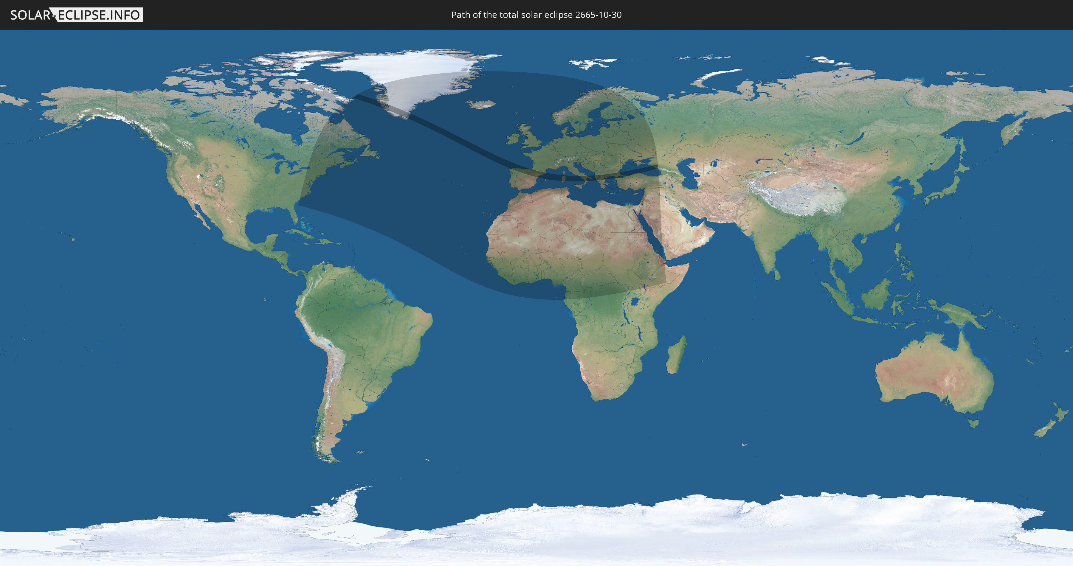
Die Sonnenfinsternis am 30.10.2665 kann man in 103 Ländern als partielle Sonnenfinsternis beobachten.
Der Finsternispfad verläuft durch 11 Länder. Nur in diesen Ländern ist sie als totale Sonnenfinsternis zu sehen.
In den folgenden Ländern ist die Sonnenfinsternis total zu sehen
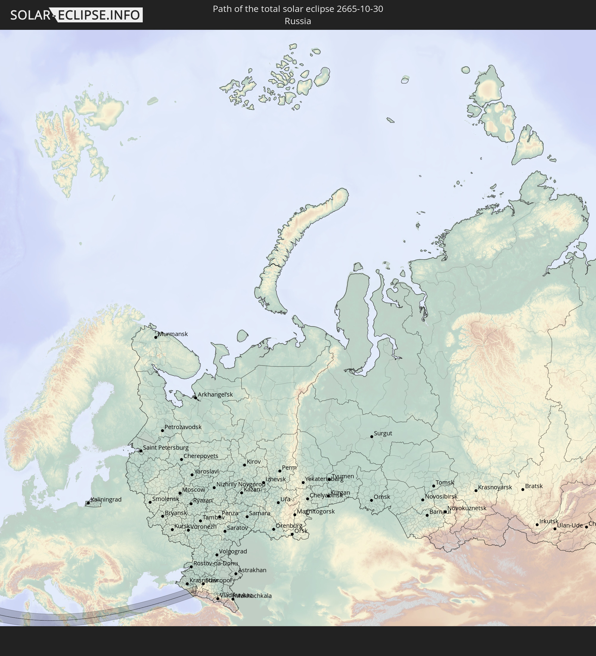 Russland
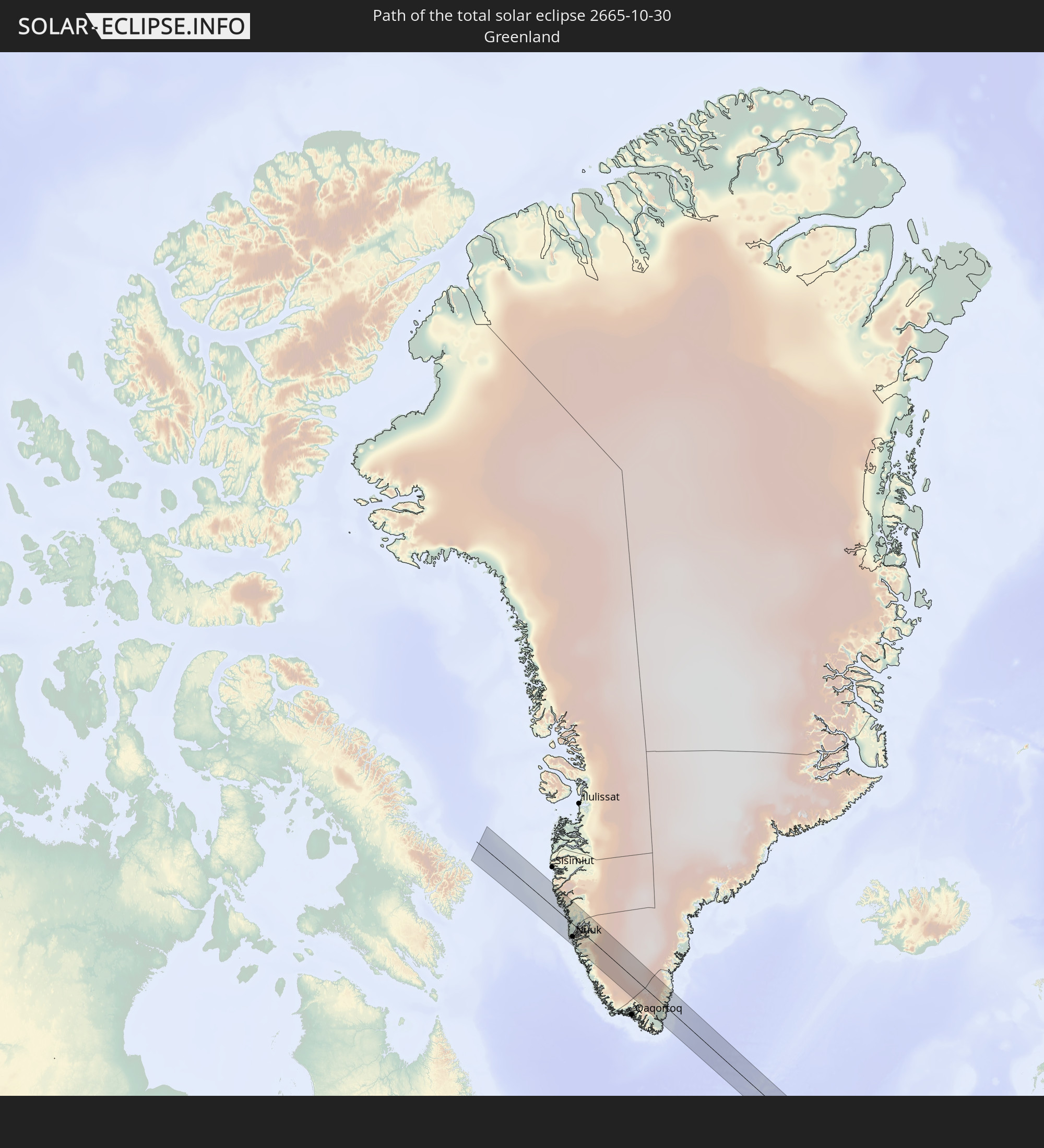 Grönland
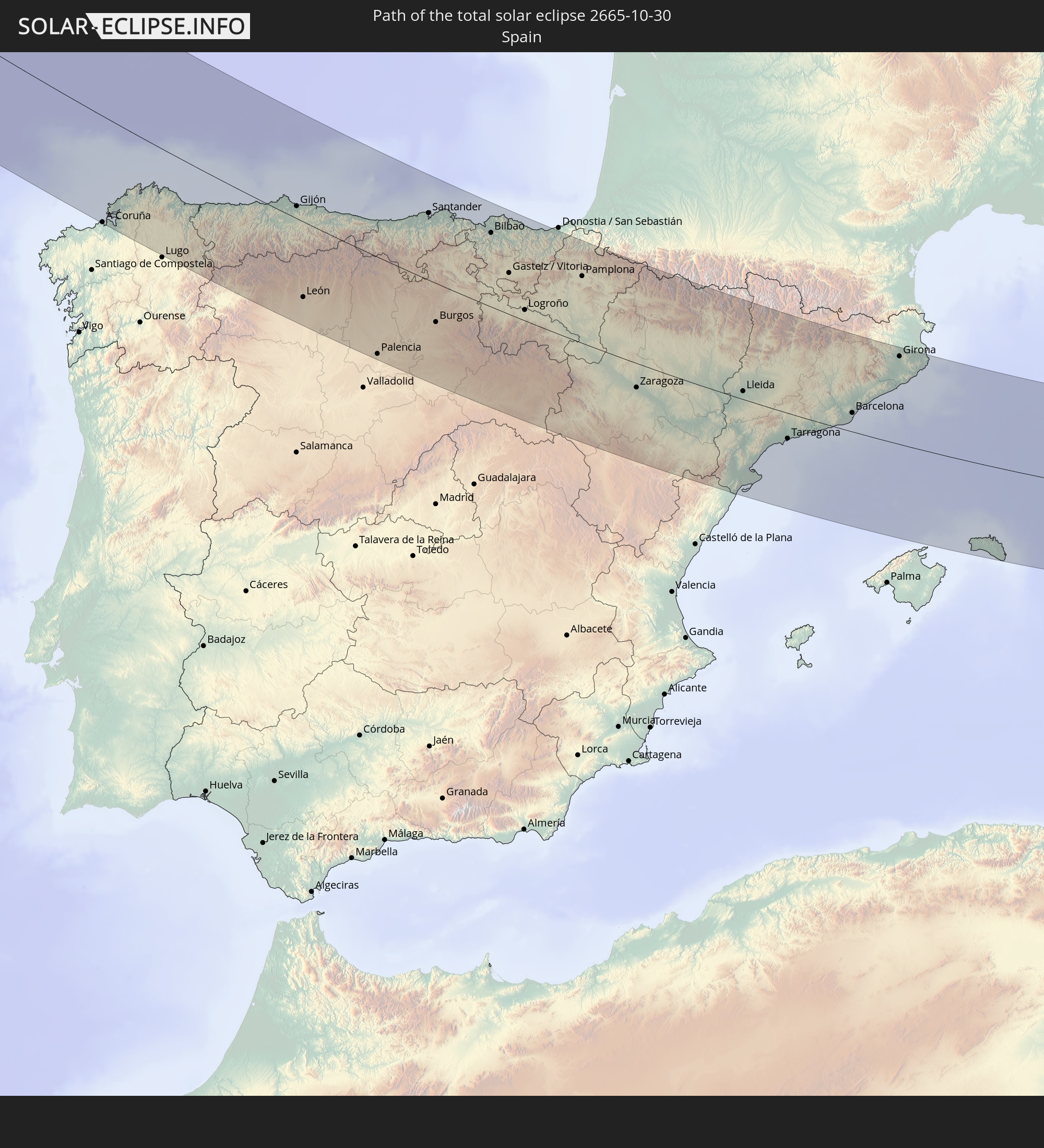 Spanien
 Frankreich
 Italien
 Albanien
 Griechenland
 Mazedonien
 Bulgarien
 Türkei
 Georgien
In den folgenden Ländern ist die Sonnenfinsternis partiell zu sehen
 Russland
 Vereinigte Staaten
 Kanada
 Grönland
 Bermuda
 Saint-Pierre und Miquelon
 Portugal
 Kap Verde
 Island
 Spanien
 Senegal
 Mauretanien
 Gambia
 Guinea-Bissau
 Guinea
 Sierra Leone
 Marokko
 Mali
Mali
 Liberia
 Irland
 Spitzbergen
 Algerien
 Vereinigtes Königreich
 Elfenbeinküste
 Färöer
 Burkina Faso
 Gibraltar
 Frankreich
 Isle of Man
 Ghana
Ghana
 Guernsey
 Jersey
 Togo
Togo
 Niger
Niger
 Benin
Benin
 Andorra
 Belgien
 Nigeria
 Niederlande
 Norwegen
 Äquatorialguinea
 Luxemburg
 Deutschland
 Schweiz
 São Tomé und Príncipe
 Italien
 Monaco
 Tunesien
 Dänemark
 Kamerun
 Gabun
Gabun
 Libyen
 Liechtenstein
 Österreich
 Schweden
 Republik Kongo
 Tschechien
 Demokratische Republik Kongo
 San Marino
 Vatikanstadt
 Slowenien
 Tschad
 Kroatien
 Polen
Polen
 Malta
Malta
 Zentralafrikanische Republik
 Bosnien und Herzegowina
 Ungarn
 Slowakei
 Montenegro
 Serbien
 Albanien
 Åland Islands
 Griechenland
 Rumänien
 Mazedonien
 Finnland
 Litauen
 Lettland
 Estland
 Sudan
Sudan
 Ukraine
 Bulgarien
 Weißrussland
 Ägypten
 Türkei
 Moldawien
 Uganda
 Republik Zypern
 Äthiopien
 Kenia
Kenia
 Staat Palästina
 Israel
 Saudi-Arabien
 Jordanien
 Libanon
 Syrien
 Eritrea
 Irak
Irak
 Georgien
 Somalia
 Dschibuti
 Jemen
Jemen
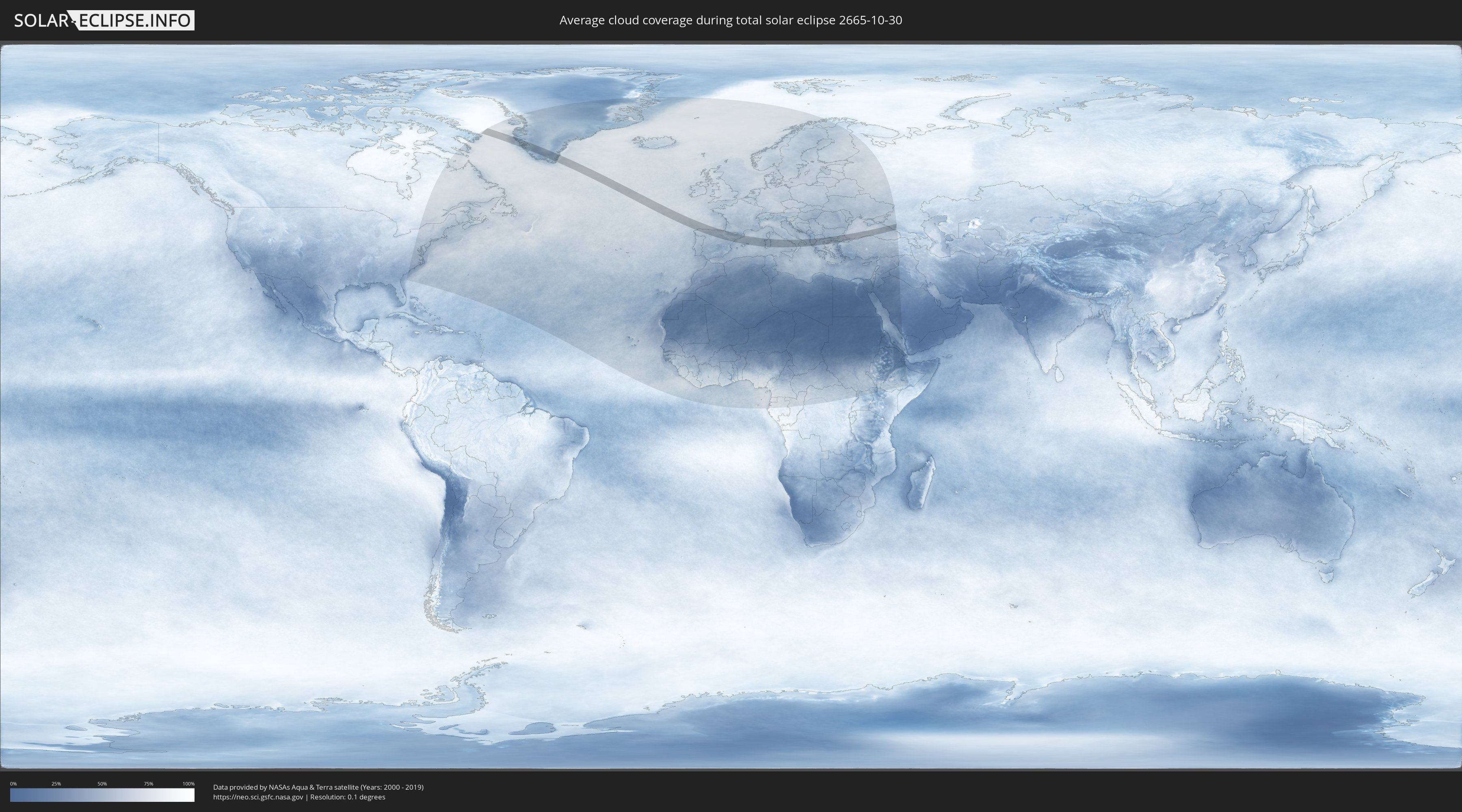
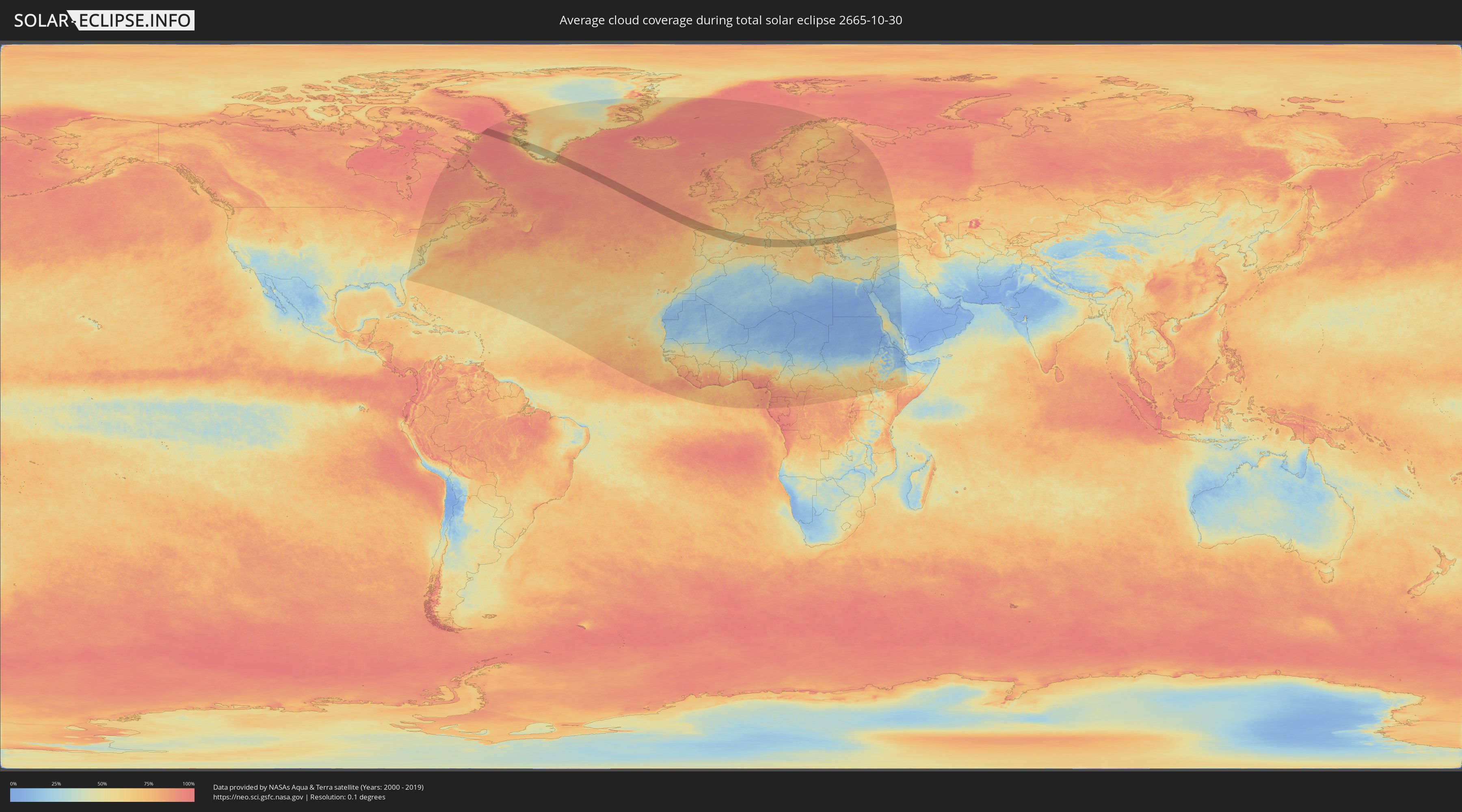
Wie wird das Wetter während der totalen Sonnenfinsternis am 30.10.2665?
Wo ist der beste Ort, um die totale Sonnenfinsternis vom 30.10.2665 zu beobachten?
Die folgenden Karten zeigen die durchschnittliche Bewölkung für den Tag, an dem die totale Sonnenfinsternis
stattfindet. Mit Hilfe der Karten lässt sich der Ort entlang des Finsternispfades eingrenzen,
der die besten Aussichen auf einen klaren wolkenfreien Himmel bietet.
Trotzdem muss man immer lokale Gegenenheiten beachten und sollte sich genau über das Wetter an seinem
gewählten Beobachtungsort informieren.
Die Daten stammen von den beiden NASA-Satelliten
AQUA und TERRA
und wurden über einen Zeitraum von 19 Jahren (2000 - 2019) gemittelt.
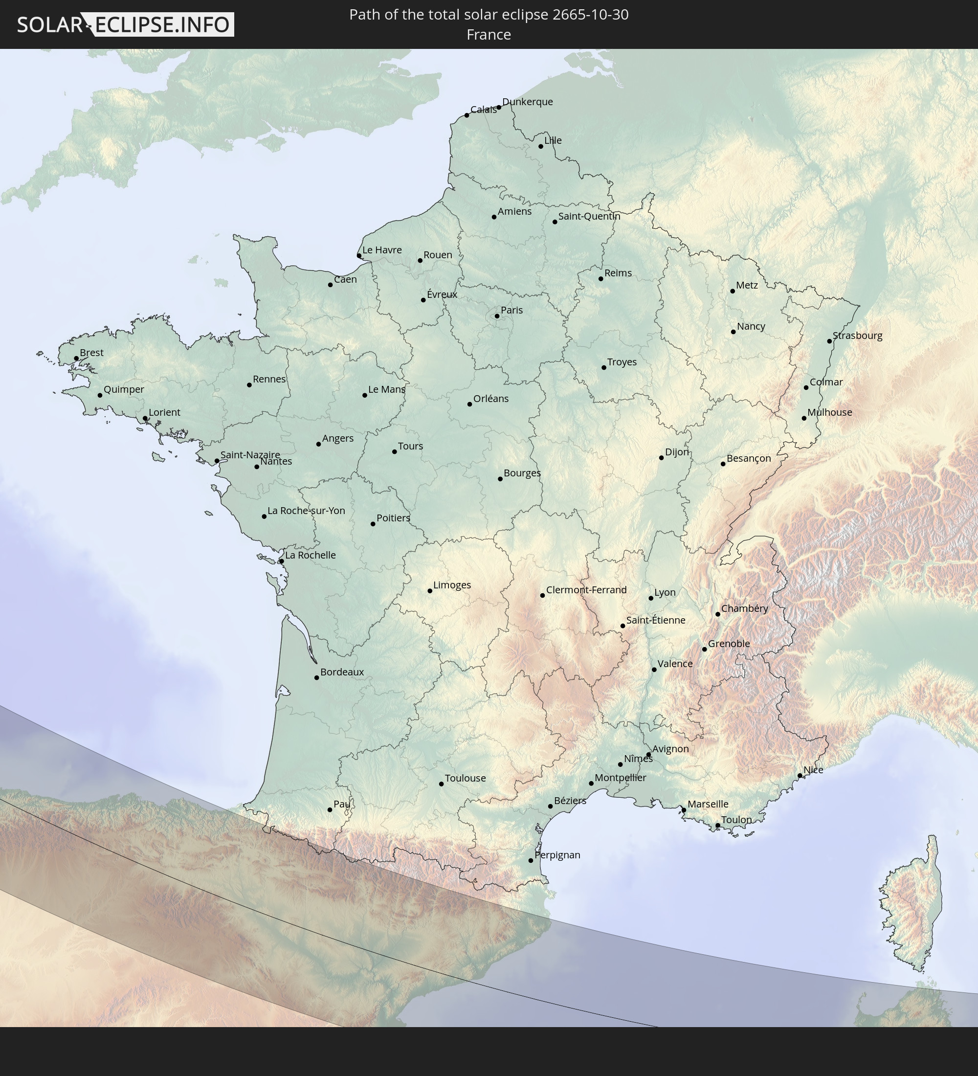
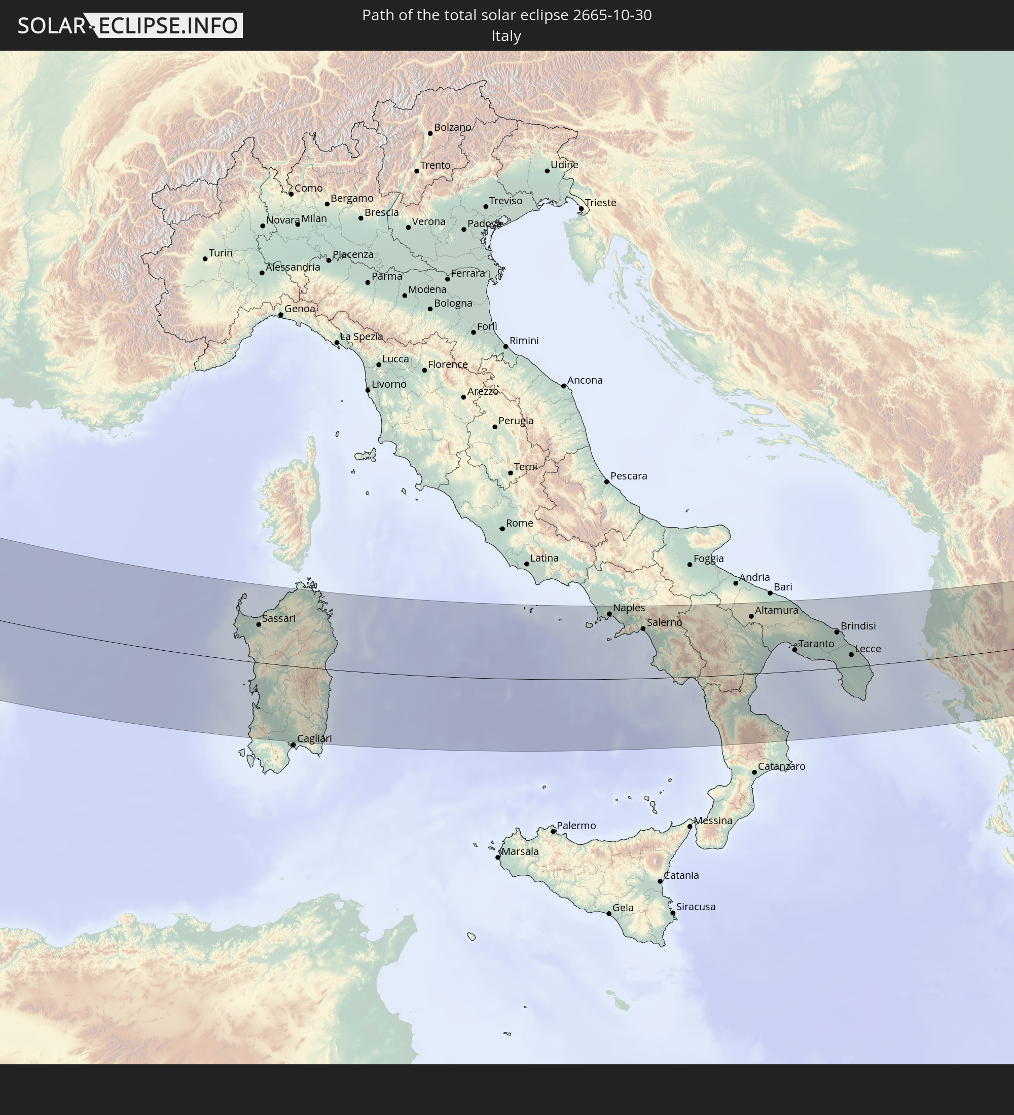
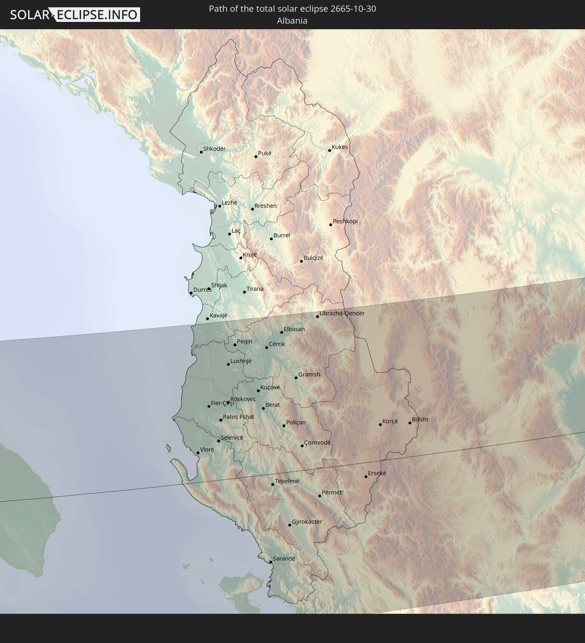
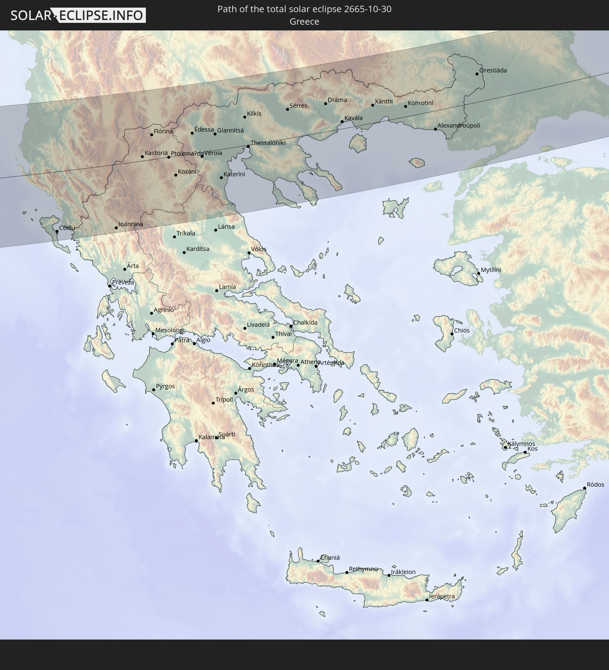
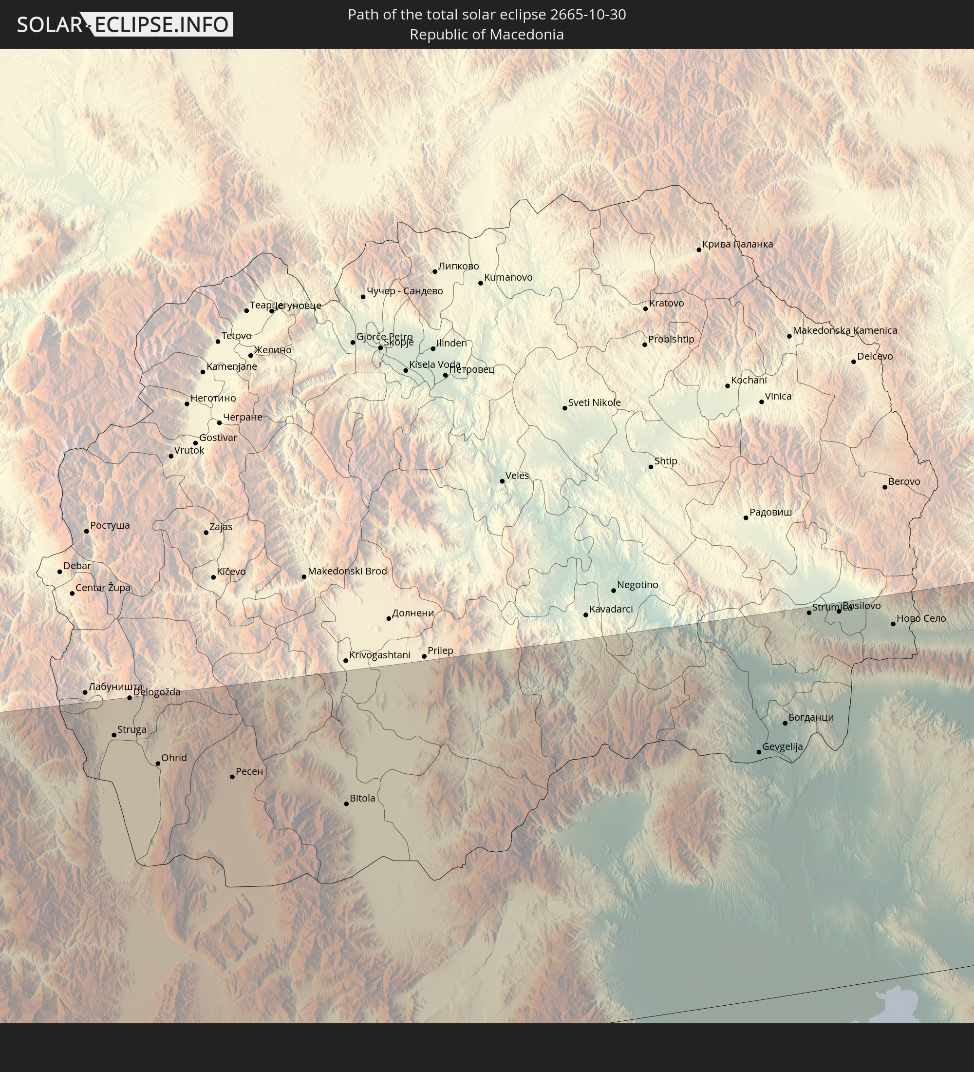
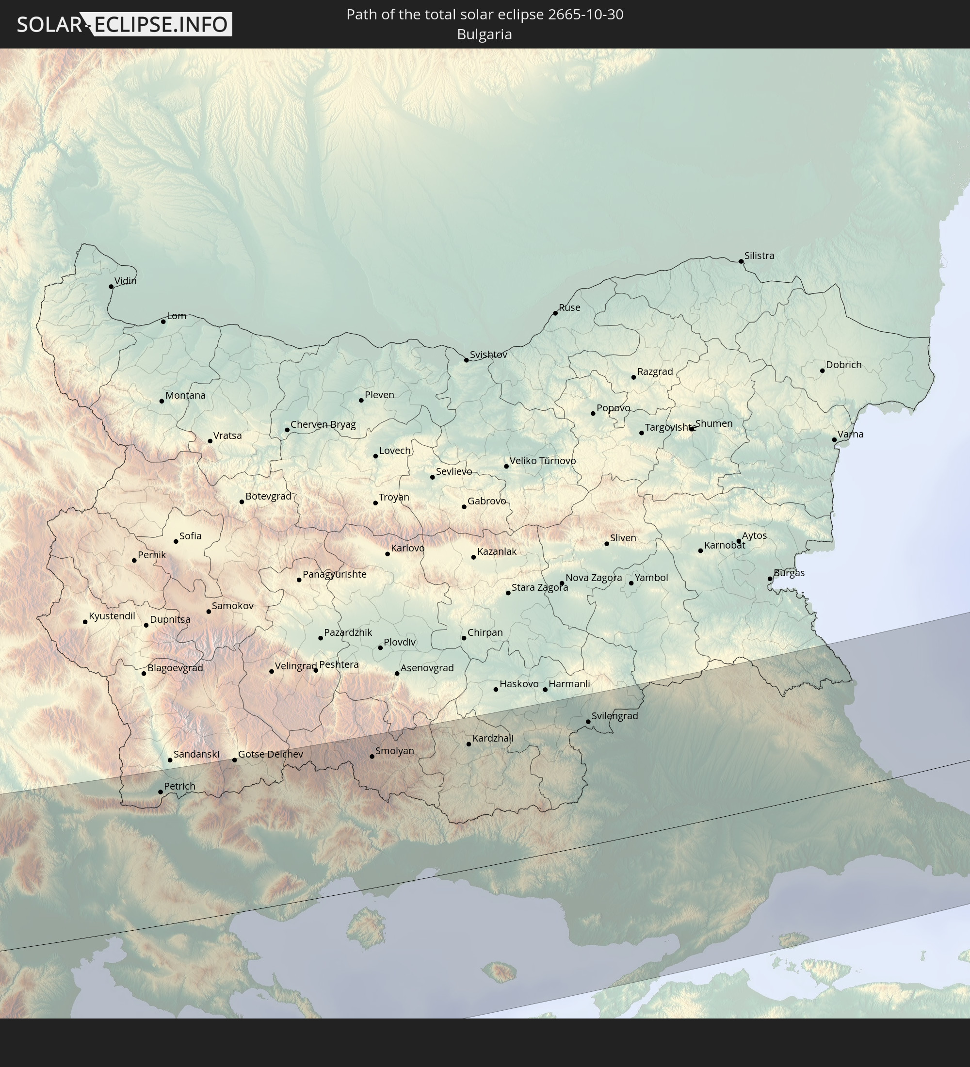
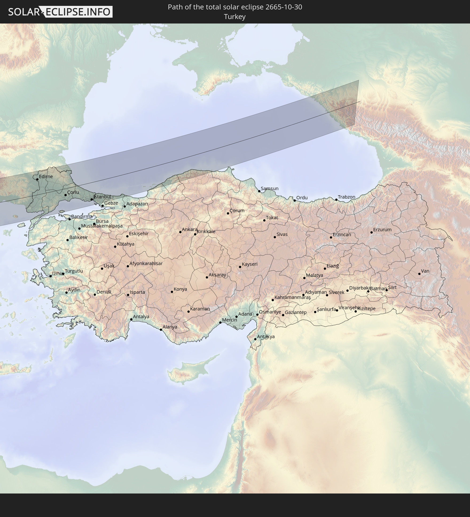
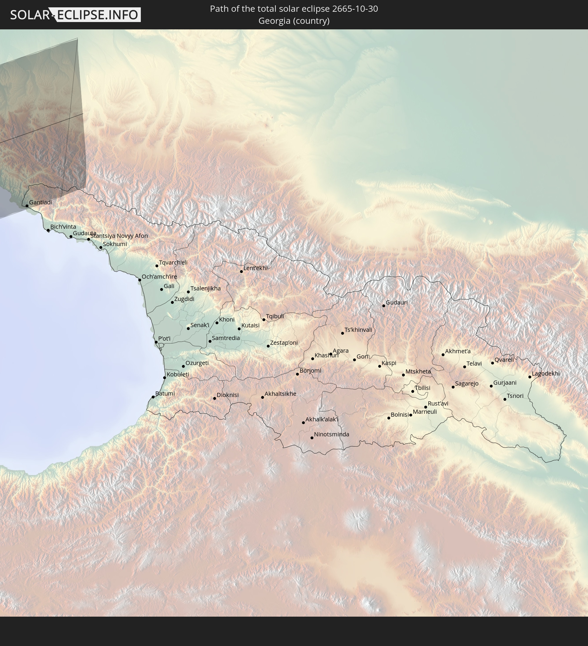
Detaillierte Länderkarten
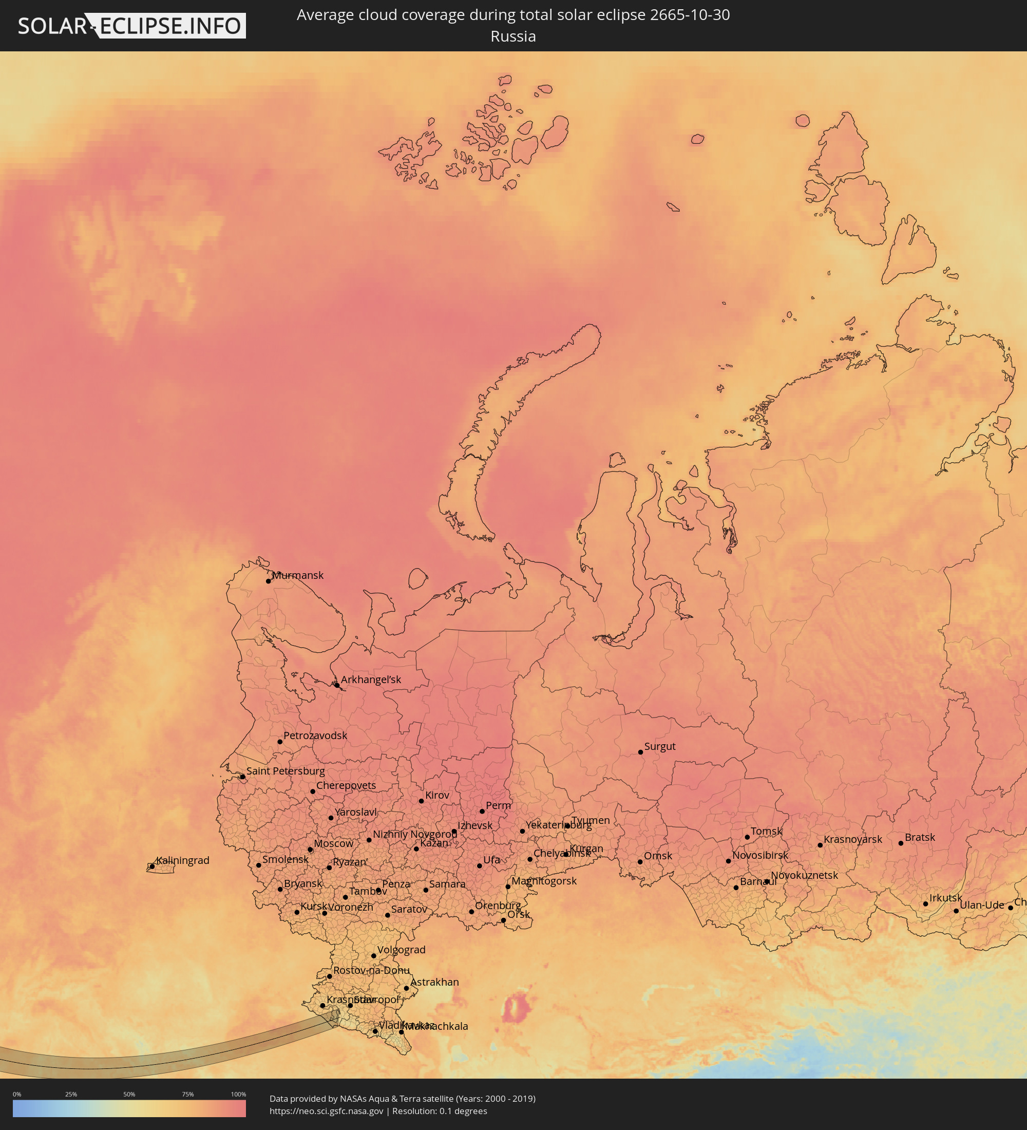 Russland
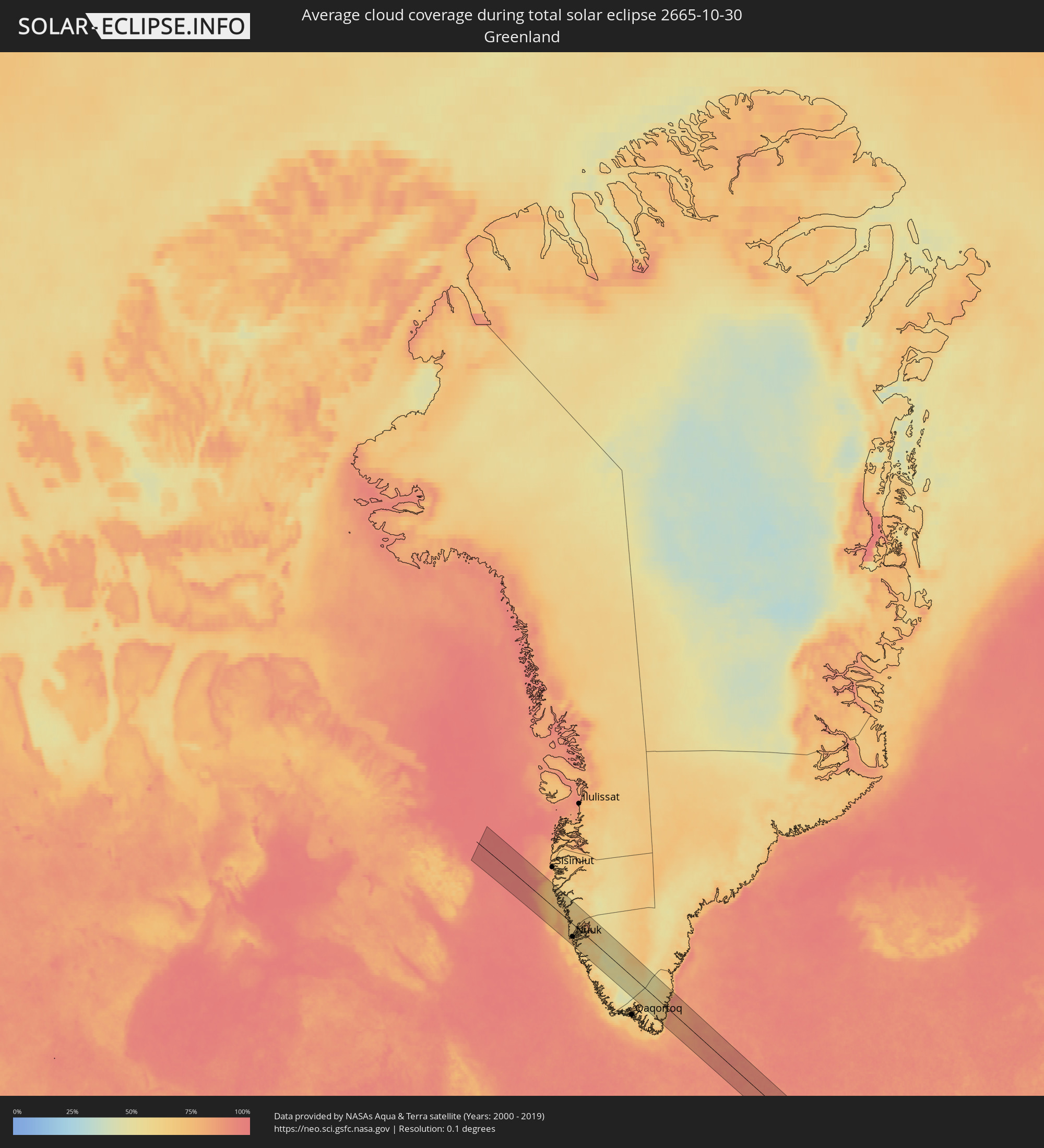 Grönland
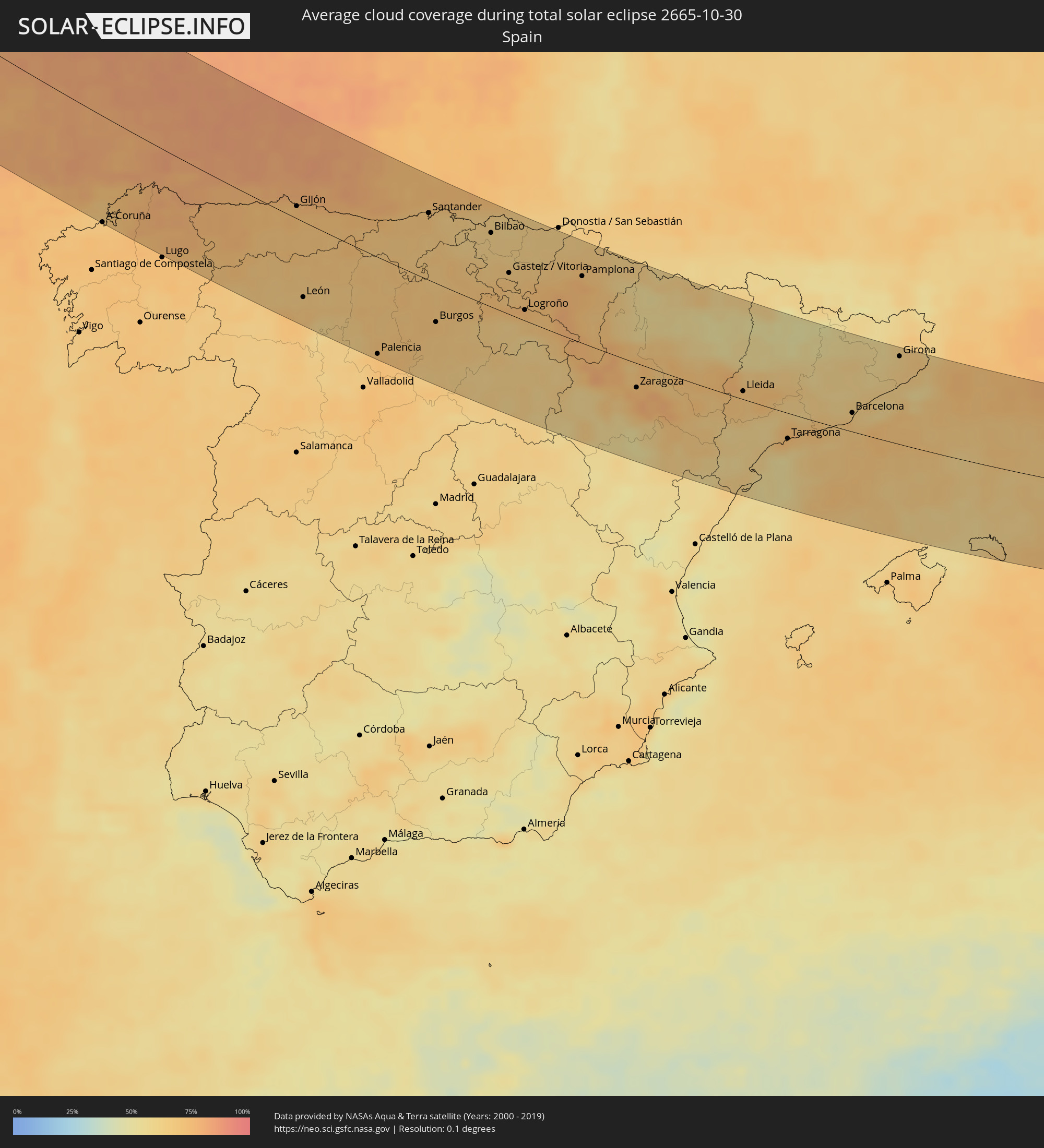 Spanien
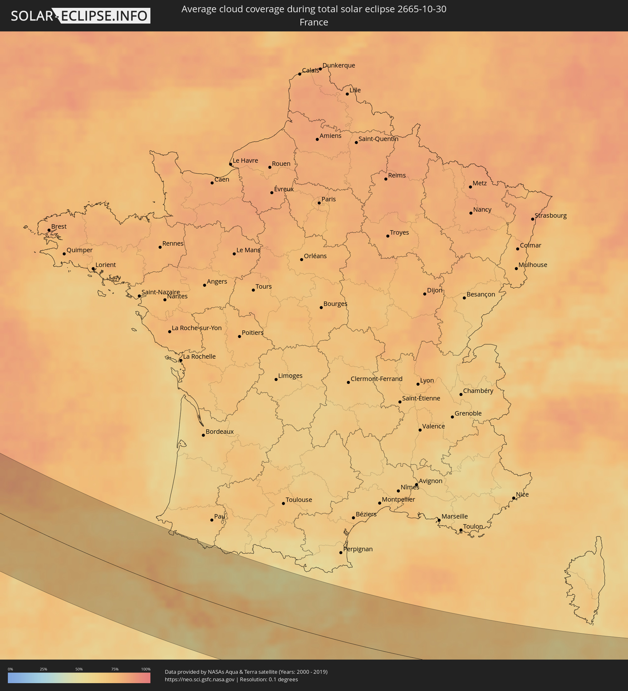 Frankreich
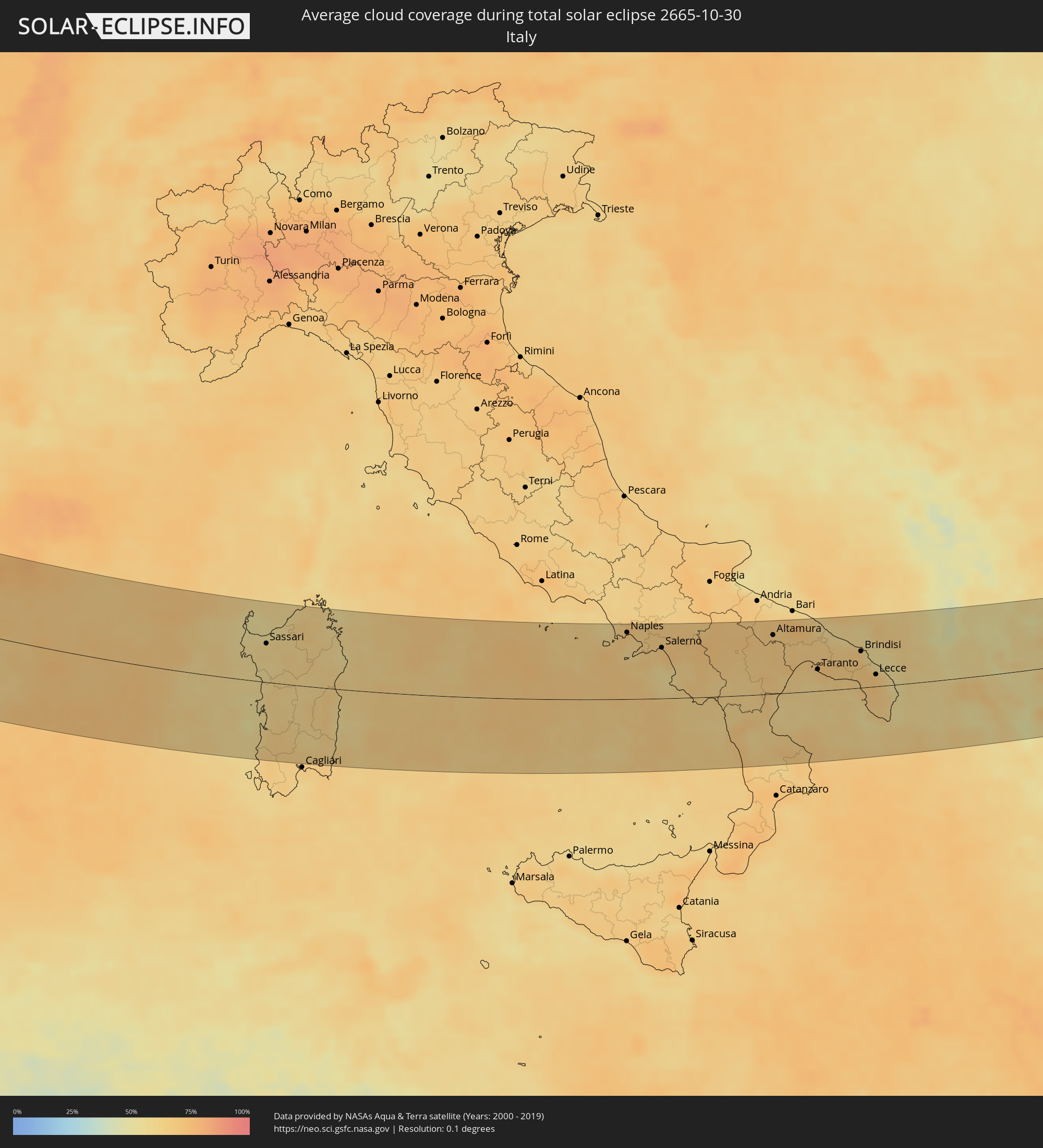 Italien
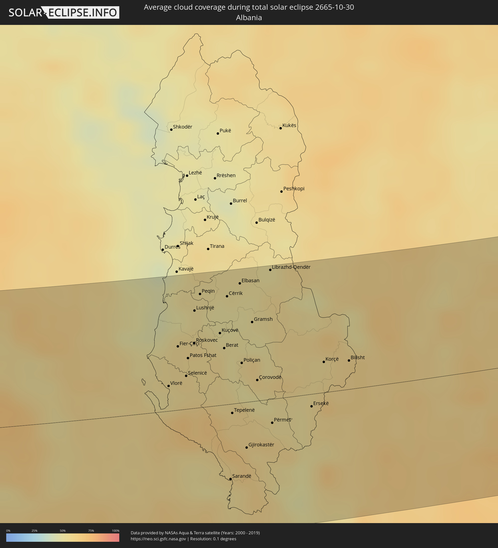 Albanien
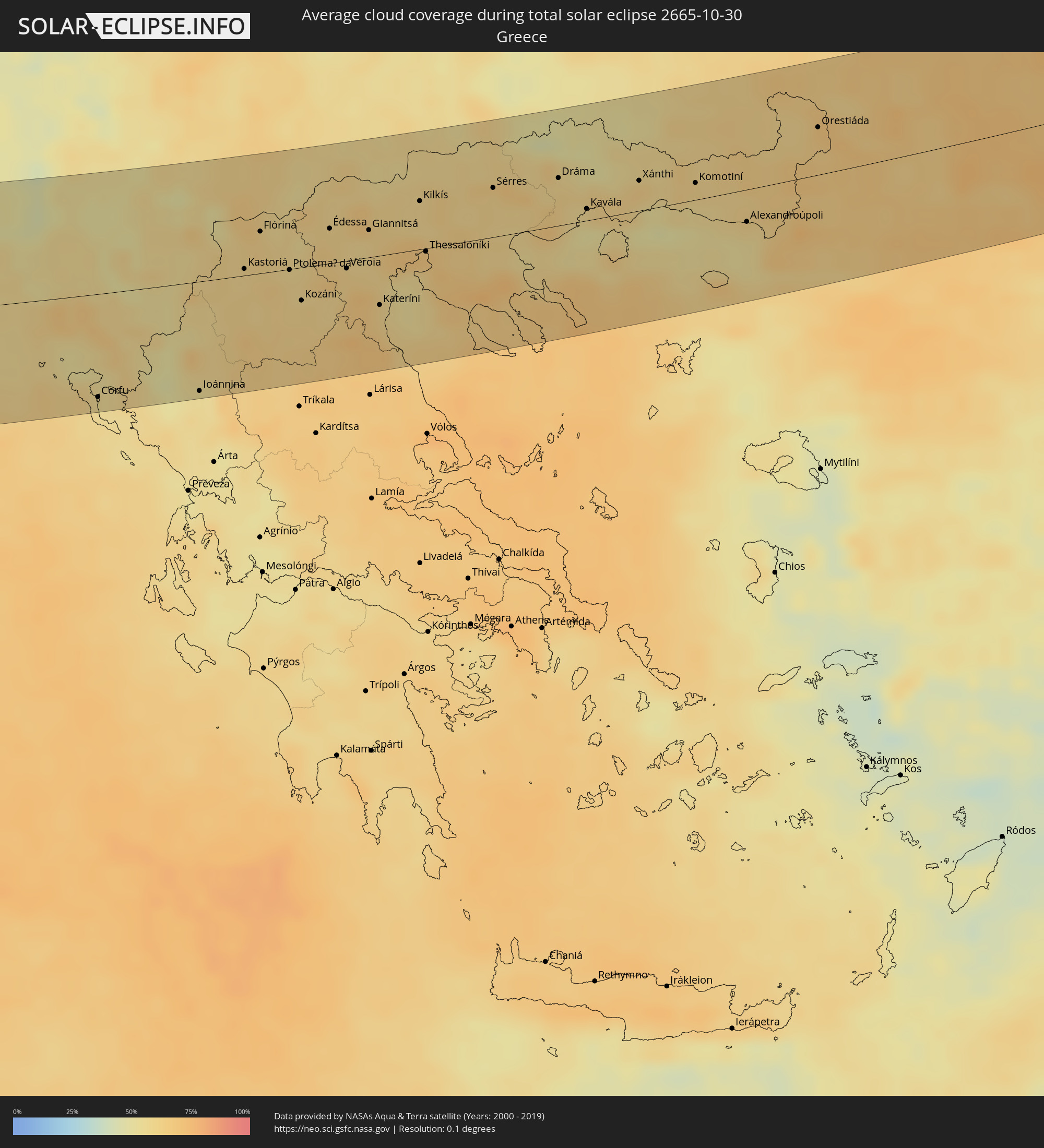 Griechenland
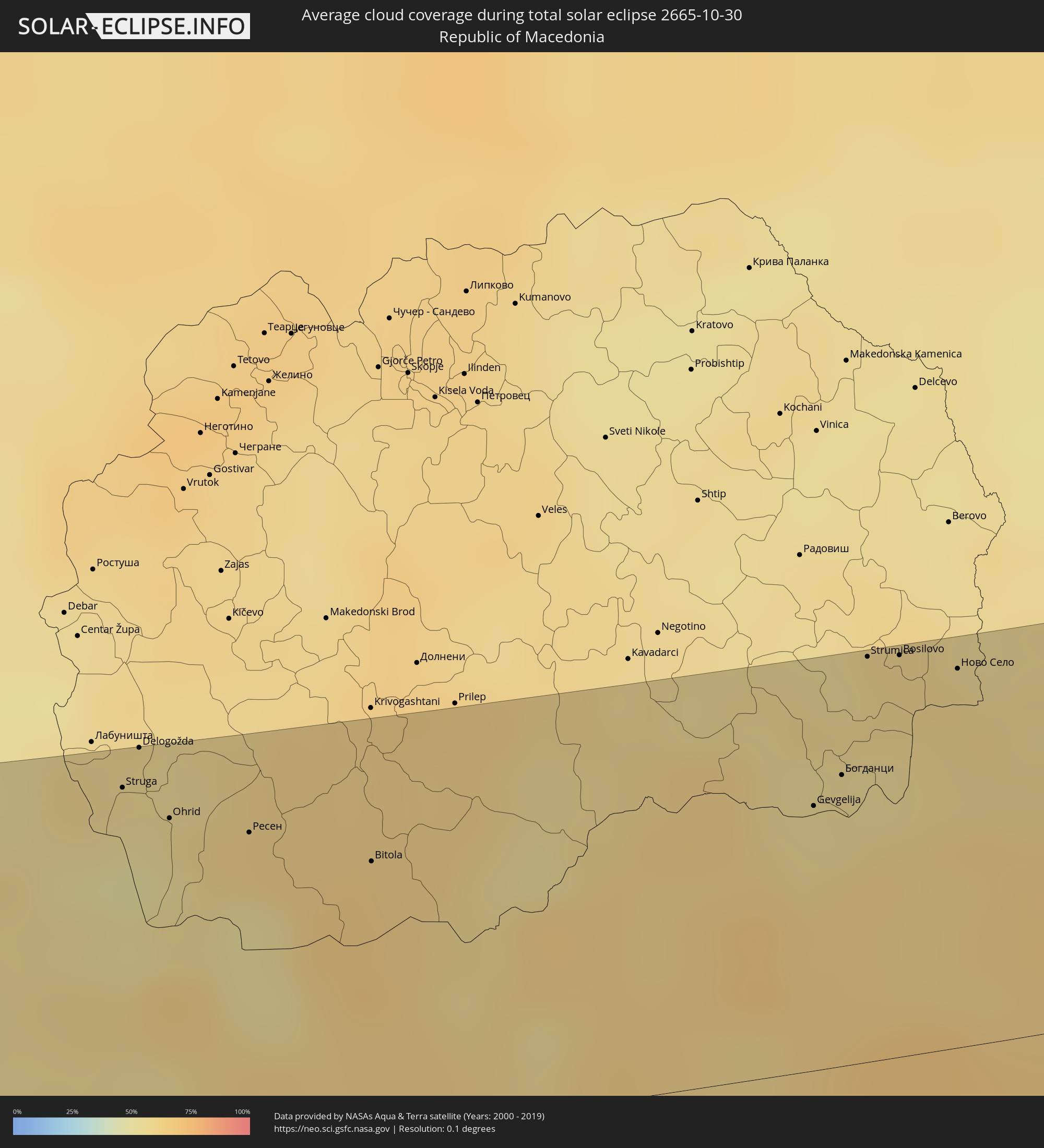 Mazedonien
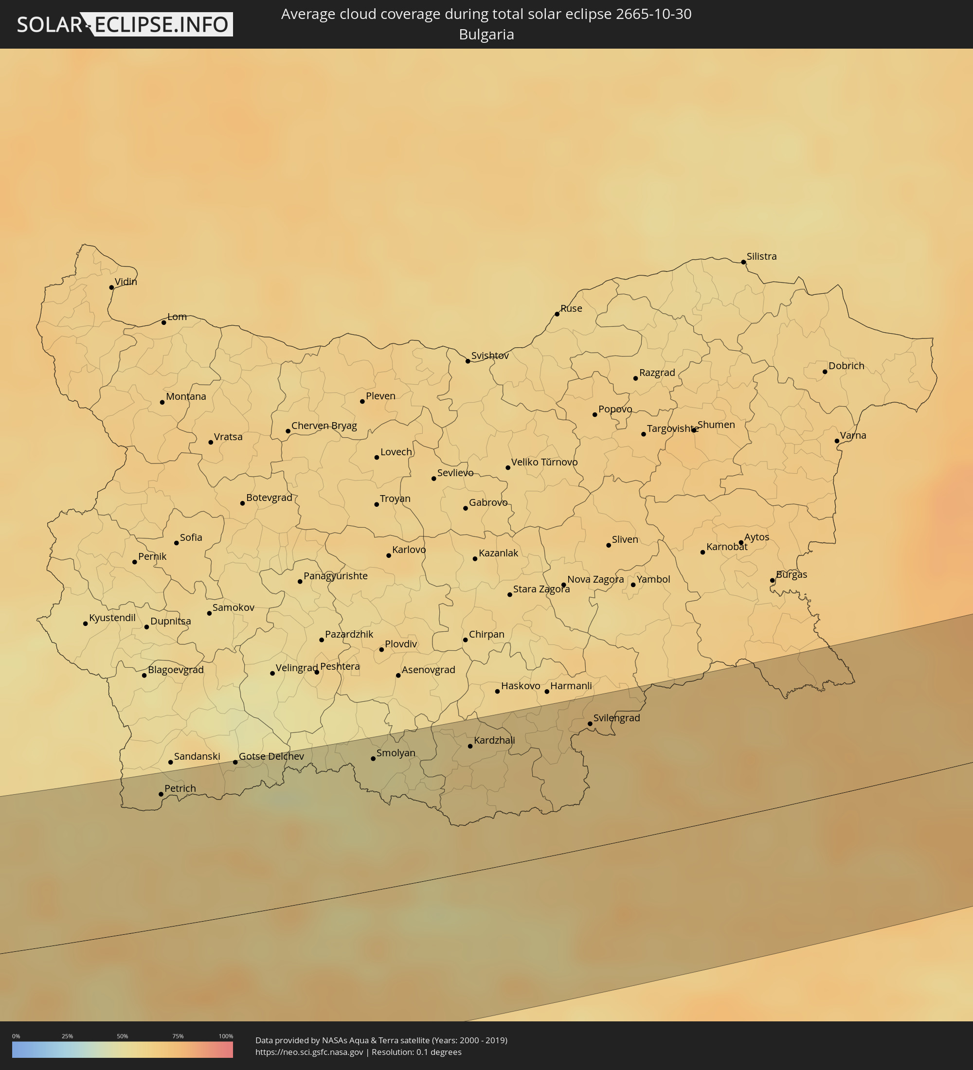 Bulgarien
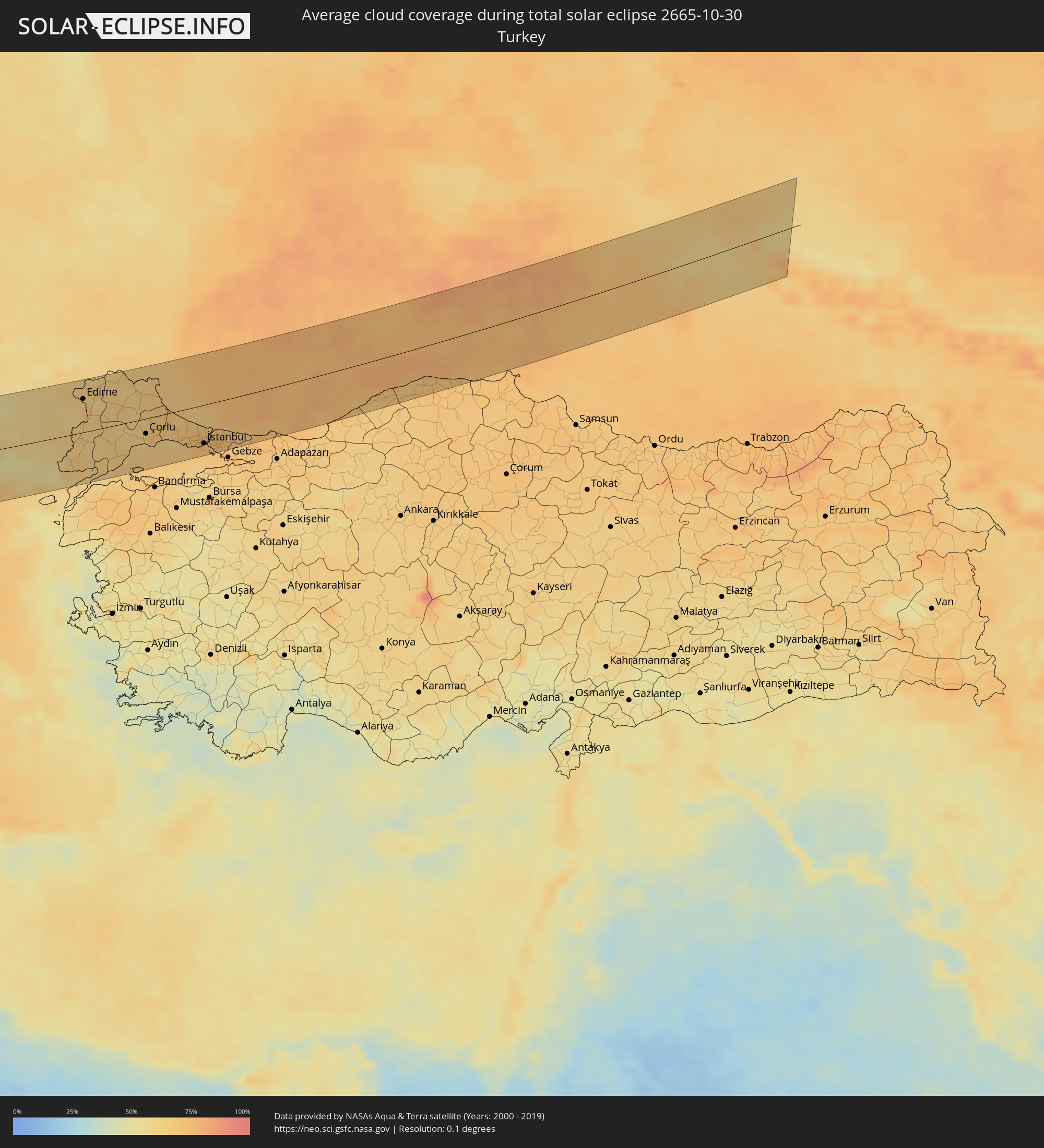 Türkei
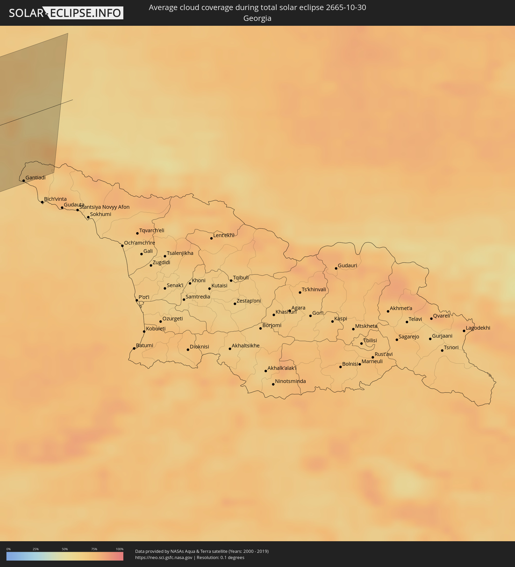 Georgien
Orte im Finsternispfad
Die nachfolgene Tabelle zeigt Städte und Orte mit mehr als 5.000 Einwohnern, die sich im Finsternispfad befinden. Städte mit mehr als 100.000 Einwohnern sind dick gekennzeichnet. Mit einem Klick auf den Ort öffnet sich eine Detailkarte die die Lage des jeweiligen Ortes zusammen mit dem Verlauf der zentralen Finsternis präsentiert.
| Ort | Typ | Dauer der Verfinsterung | Ortszeit bei maximaler Verfinsterung | Entfernung zur Zentrallinie | Ø Bewölkung |
|
Nuuk, Sermersooq
|
total | - | 09:17:26 UTC-03:00 | 45 km | 68% |
|
A Coruña, Galicia
|
total | - | 14:06:40 UTC+01:00 | 105 km | 69% |
|
Avilés, Asturias
|
total | - | 14:11:01 UTC+01:00 | 5 km | 73% |
|
Oviedo, Asturias
|
total | - | 14:11:21 UTC+01:00 | 11 km | 72% |
|
Gijón, Asturias
|
total | - | 14:11:31 UTC+01:00 | 13 km | 74% |
|
León, Castille and León
|
total | - | 14:12:34 UTC+01:00 | 78 km | 69% |
|
Palencia, Castille and León
|
total | - | 14:15:04 UTC+01:00 | 102 km | 73% |
|
Santander, Cantabria
|
total | - | 14:14:55 UTC+01:00 | 70 km | 70% |
|
Burgos, Castille and León
|
total | - | 14:16:14 UTC+01:00 | 41 km | 68% |
|
Bilbao, Basque Country
|
total | - | 14:16:42 UTC+01:00 | 78 km | 63% |
|
Gasteiz / Vitoria, Basque Country
|
total | - | 14:17:35 UTC+01:00 | 44 km | 70% |
|
Logroño, La Rioja
|
total | - | 14:18:23 UTC+01:00 | 12 km | 73% |
|
Pamplona, Navarre
|
total | - | 14:19:27 UTC+01:00 | 72 km | 76% |
|
Zaragoza, Aragon
|
total | - | 14:22:06 UTC+01:00 | 27 km | 75% |
|
Lleida, Catalonia
|
total | - | 14:24:48 UTC+01:00 | 9 km | 69% |
|
Tarragona, Catalonia
|
total | - | 14:26:30 UTC+01:00 | 29 km | 59% |
|
Manresa, Catalonia
|
total | - | 14:26:47 UTC+01:00 | 50 km | 60% |
|
Terrassa, Catalonia
|
total | - | 14:27:18 UTC+01:00 | 37 km | 61% |
|
Barcelona, Catalonia
|
total | - | 14:27:46 UTC+01:00 | 21 km | 66% |
|
Mataró, Catalonia
|
total | - | 14:28:04 UTC+01:00 | 44 km | 61% |
|
Girona, Catalonia
|
total | - | 14:28:11 UTC+01:00 | 100 km | 63% |
|
Alghero, Sardinia
|
total | - | 14:39:01 UTC+01:00 | 31 km | 55% |
|
Sassari, Sardinia
|
total | - | 14:39:10 UTC+01:00 | 51 km | 59% |
|
Nuoro, Sardinia
|
total | - | 14:40:54 UTC+01:00 | 13 km | 59% |
|
Olbia, Sardinia
|
total | - | 14:40:20 UTC+01:00 | 81 km | 59% |
|
Naples, Campania
|
total | - | 14:47:14 UTC+01:00 | 89 km | 66% |
|
Somma Vesuviana, Campania
|
total | - | 14:47:28 UTC+01:00 | 91 km | 63% |
|
Castellammare di Stabia, Campania
|
total | - | 14:47:47 UTC+01:00 | 71 km | 64% |
|
Avellino, Campania
|
total | - | 14:47:52 UTC+01:00 | 94 km | 65% |
|
Salerno, Campania
|
total | - | 14:48:13 UTC+01:00 | 68 km | 66% |
|
Battipaglia, Campania
|
total | - | 14:48:34 UTC+01:00 | 60 km | 65% |
|
Potenza, Basilicate
|
total | - | 14:49:36 UTC+01:00 | 61 km | 67% |
|
Cosenza, Calabria
|
total | - | 14:52:08 UTC+01:00 | 90 km | 65% |
|
Altamura, Apulia
|
total | - | 14:50:16 UTC+01:00 | 78 km | 67% |
|
Matera, Basilicate
|
total | - | 14:50:35 UTC+01:00 | 60 km | 68% |
|
Taranto, Apulia
|
total | - | 14:51:45 UTC+01:00 | 29 km | 65% |
|
Monopoli, Apulia
|
total | - | 14:51:01 UTC+01:00 | 88 km | 64% |
|
Martina Franca, Apulia
|
total | - | 14:51:26 UTC+01:00 | 60 km | 65% |
|
Francavilla Fontana, Apulia
|
total | - | 14:51:59 UTC+01:00 | 40 km | 68% |
|
Brindisi, Apulia
|
total | - | 14:52:16 UTC+01:00 | 48 km | 69% |
|
Lecce, Apulia
|
total | - | 14:52:58 UTC+01:00 | 16 km | 68% |
|
Vlorë, Vlorë
|
total | - | 14:54:20 UTC+01:00 | 17 km | 55% |
|
Fier-Çifçi, Fier
|
total | - | 14:54:03 UTC+01:00 | 44 km | 57% |
|
Patos Fshat, Fier
|
total | - | 14:54:16 UTC+01:00 | 35 km | 57% |
|
Lushnjë, Fier
|
total | - | 14:53:52 UTC+01:00 | 68 km | 56% |
|
Ballsh, Fier
|
total | - | 14:54:25 UTC+01:00 | 30 km | 57% |
|
Peqin, Elbasan
|
total | - | 14:53:46 UTC+01:00 | 79 km | 52% |
|
Kuçovë, Berat
|
total | - | 14:54:20 UTC+01:00 | 50 km | 54% |
|
Corfu, Ionian Islands
|
total | - | 15:56:06 UTC+02:00 | 80 km | 58% |
|
Berat, Berat
|
total | - | 14:54:31 UTC+01:00 | 39 km | 52% |
|
Cërrik, Elbasan
|
total | - | 14:54:03 UTC+01:00 | 75 km | 50% |
|
Sarandë, Vlorë
|
total | - | 14:55:49 UTC+01:00 | 53 km | 54% |
|
Tepelenë, Gjirokastër
|
total | - | 14:55:12 UTC+01:00 | 6 km | 59% |
|
Elbasan, Elbasan
|
total | - | 14:54:03 UTC+01:00 | 83 km | 52% |
|
Poliçan, Berat
|
total | - | 14:54:49 UTC+01:00 | 28 km | 51% |
|
Gjirokastër, Gjirokastër
|
total | - | 14:55:40 UTC+01:00 | 32 km | 63% |
|
Gramsh, Elbasan
|
total | - | 14:54:31 UTC+01:00 | 55 km | 51% |
|
Çorovodë, Berat
|
total | - | 14:55:07 UTC+01:00 | 14 km | 51% |
|
Librazhd-Qendër, Elbasan
|
total | - | 14:54:12 UTC+01:00 | 90 km | 54% |
|
Përmet, Gjirokastër
|
total | - | 14:55:40 UTC+01:00 | 17 km | 59% |
|
Vevčani, Vevčani
|
total | - | 14:54:25 UTC+01:00 | 92 km | 55% |
|
Velesta
|
total | - | 14:54:28 UTC+01:00 | 91 km | 55% |
|
Struga, Struga
|
total | - | 14:54:36 UTC+01:00 | 84 km | 52% |
|
Ersekë, Korçë
|
total | - | 14:55:52 UTC+01:00 | 9 km | 56% |
|
Delogožda, Struga
|
total | - | 14:54:32 UTC+01:00 | 92 km | 57% |
|
Korçë, Korçë
|
total | - | 14:55:34 UTC+01:00 | 21 km | 57% |
|
Ohrid, Ohrid
|
total | - | 14:54:50 UTC+01:00 | 76 km | 52% |
|
Ioánnina, Epirus
|
total | - | 15:57:04 UTC+02:00 | 85 km | 55% |
|
Ресен, Resen Municipality
|
total | - | 14:55:06 UTC+01:00 | 71 km | 59% |
|
Demir Hisar, Demir Hisar
|
total | - | 14:55:06 UTC+01:00 | 83 km | 61% |
|
Bitola, Bitola
|
total | - | 14:55:32 UTC+01:00 | 60 km | 65% |
|
Могила, Mogila
|
total | - | 14:55:28 UTC+01:00 | 68 km | 62% |
|
Flórina, West Macedonia
|
total | - | 15:56:00 UTC+02:00 | 32 km | 62% |
|
Novaci, Novaci
|
total | - | 14:55:39 UTC+01:00 | 60 km | 60% |
|
Ptolemaḯda, West Macedonia
|
total | - | 15:56:41 UTC+02:00 | 1 km | 60% |
|
Kozáni, West Macedonia
|
total | - | 15:57:07 UTC+02:00 | 26 km | 61% |
|
Édessa, Central Macedonia
|
total | - | 15:56:38 UTC+02:00 | 27 km | 62% |
|
Náousa, Central Macedonia
|
total | - | 15:56:55 UTC+02:00 | 7 km | 64% |
|
Véroia, Central Macedonia
|
total | - | 15:57:13 UTC+02:00 | 6 km | 61% |
|
Демир Капија, Demir Kapija
|
total | - | 14:55:56 UTC+01:00 | 90 km | 56% |
|
Giannitsá, Central Macedonia
|
total | - | 15:57:02 UTC+02:00 | 21 km | 59% |
|
Gevgelija, Gevgelija
|
total | - | 14:56:36 UTC+01:00 | 58 km | 57% |
|
Kateríni, Central Macedonia
|
total | - | 15:57:55 UTC+02:00 | 38 km | 63% |
|
Valandovo, Valandovo Municipality
|
total | - | 14:56:23 UTC+01:00 | 77 km | 56% |
|
Богданци, Bogdanci
|
total | - | 14:56:35 UTC+01:00 | 64 km | 56% |
|
Strumica, Strumica
|
total | - | 14:56:17 UTC+01:00 | 89 km | 58% |
|
Star Dojran, Dojran
|
total | - | 14:56:45 UTC+01:00 | 60 km | 58% |
|
Bosilovo, Bosilovo
|
total | - | 14:56:22 UTC+01:00 | 88 km | 58% |
|
Kilkís, Central Macedonia
|
total | - | 15:57:12 UTC+02:00 | 37 km | 59% |
|
Ново Село, Novo Selo
|
total | - | 14:56:34 UTC+01:00 | 83 km | 58% |
|
Peraía, Central Macedonia
|
total | - | 15:58:00 UTC+02:00 | 18 km | 57% |
|
Thessaloníki, Central Macedonia
|
total | - | 15:57:47 UTC+02:00 | 2 km | 58% |
|
Petrich, Blagoevgrad
|
total | - | 15:56:55 UTC+02:00 | 77 km | 58% |
|
Sérres, Central Macedonia
|
total | - | 15:57:44 UTC+02:00 | 37 km | 62% |
|
Gotse Delchev, Blagoevgrad
|
total | - | 15:57:11 UTC+02:00 | 88 km | 56% |
|
Dráma, East Macedonia and Thrace
|
total | - | 15:58:13 UTC+02:00 | 36 km | 59% |
|
Kavála, East Macedonia and Thrace
|
total | - | 15:58:47 UTC+02:00 | 9 km | 51% |
|
Smolyan, Smolyan
|
total | - | 15:58:04 UTC+02:00 | 75 km | 51% |
|
Xánthi, East Macedonia and Thrace
|
total | - | 15:58:57 UTC+02:00 | 23 km | 62% |
|
Madan, Smolyan
|
total | - | 15:58:26 UTC+02:00 | 62 km | 56% |
|
Nedelino, Smolyan
|
total | - | 15:58:39 UTC+02:00 | 54 km | 57% |
|
Zlatograd, Smolyan
|
total | - | 15:58:46 UTC+02:00 | 47 km | 58% |
|
Kardzhali, Kŭrdzhali
|
total | - | 15:58:36 UTC+02:00 | 71 km | 58% |
|
Komotiní, East Macedonia and Thrace
|
total | - | 15:59:27 UTC+02:00 | 13 km | 60% |
|
Krumovgrad, Kŭrdzhali
|
total | - | 15:59:08 UTC+02:00 | 47 km | 61% |
|
Alexandroúpoli, East Macedonia and Thrace
|
total | - | 16:00:17 UTC+02:00 | 24 km | 54% |
|
Lyubimets, Khaskovo
|
total | - | 15:58:58 UTC+02:00 | 79 km | 64% |
|
Svilengrad, Khaskovo
|
total | - | 15:59:10 UTC+02:00 | 70 km | 65% |
|
Orestiáda, East Macedonia and Thrace
|
total | - | 15:59:52 UTC+02:00 | 36 km | 64% |
|
Edirne, Edirne
|
total | - | 16:59:37 UTC+03:00 | 54 km | 66% |
|
Keşan, Edirne
|
total | - | 17:00:57 UTC+03:00 | 37 km | 67% |
|
Uzunköprü, Edirne
|
total | - | 17:00:22 UTC+03:00 | 7 km | 65% |
|
Malkara, Tekirdağ
|
total | - | 17:01:08 UTC+03:00 | 38 km | 65% |
|
Babaeski, Kırklareli
|
total | - | 17:00:27 UTC+03:00 | 18 km | 67% |
|
Hayrabolu, Tekirdağ
|
total | - | 17:00:48 UTC+03:00 | 6 km | 66% |
|
Kırklareli, Kırklareli
|
total | - | 17:00:06 UTC+03:00 | 49 km | 68% |
|
Lüleburgaz, Kırklareli
|
total | - | 17:00:44 UTC+03:00 | 10 km | 65% |
|
Tekirdağ, Tekirdağ
|
total | - | 17:01:30 UTC+03:00 | 39 km | 66% |
|
Çorlu, Tekirdağ
|
total | - | 17:01:28 UTC+03:00 | 25 km | 66% |
|
Çerkezköy, Tekirdağ
|
total | - | 17:01:26 UTC+03:00 | 14 km | 72% |
|
Silivri, Istanbul
|
total | - | 17:01:58 UTC+03:00 | 42 km | 64% |
|
Çatalca, Istanbul
|
total | - | 17:02:02 UTC+03:00 | 39 km | 65% |
|
Kumburgaz, Istanbul
|
total | - | 17:02:14 UTC+03:00 | 52 km | 65% |
|
Esenyurt, Istanbul
|
total | - | 17:02:23 UTC+03:00 | 55 km | 71% |
|
İstanbul, Istanbul
|
total | - | 17:02:37 UTC+03:00 | 62 km | 71% |
|
Maltepe, Istanbul
|
total | - | 17:02:54 UTC+03:00 | 74 km | 71% |
|
Kandıra, Kocaeli
|
total | - | 17:03:27 UTC+03:00 | 80 km | 72% |
|
Zonguldak, Zonguldak
|
total | - | 17:04:02 UTC+03:00 | 73 km | 68% |
|
Bartın, Bartın
|
total | - | 17:04:07 UTC+03:00 | 65 km | 66% |
|
Dzhubga, Krasnodarskiy
|
total | - | 17:03:30 UTC+03:00 | 66 km | 63% |
|
Novomikhaylovskiy, Krasnodarskiy
|
total | - | 17:03:40 UTC+03:00 | 56 km | 64% |
|
Tuapse, Krasnodarskiy
|
total | - | 17:04:01 UTC+03:00 | 34 km | 59% |
|
Lazarevskoye, Krasnodarskiy
|
total | - | 17:04:26 UTC+03:00 | 7 km | 57% |
|
Khadyzhensk, Krasnodarskiy
|
total | - | 17:03:43 UTC+03:00 | 56 km | 71% |
|
Dagomys, Krasnodarskiy
|
total | - | 17:04:57 UTC+03:00 | 27 km | 62% |
|
Sochi, Krasnodarskiy
|
total | - | 17:05:05 UTC+03:00 | 36 km | 61% |
|
Apsheronsk, Krasnodarskiy
|
total | - | 17:03:44 UTC+03:00 | 55 km | 69% |
|
Khosta, Krasnodarskiy
|
total | - | 17:05:17 UTC+03:00 | 49 km | 64% |
|
Kudepsta, Krasnodarskiy
|
total | - | 17:05:19 UTC+03:00 | 52 km | 64% |
|
Adler, Krasnodarskiy
|
total | - | 17:05:26 UTC+03:00 | 59 km | 63% |
|
Khanskaya, Adygeya
|
total | - | 17:03:30 UTC+03:00 | 71 km | 68% |
|
Gantiadi
|
total | - | 18:05:35 UTC+04:00 | 68 km | 64% |
|
Maykop, Adygeya
|
total | - | 17:03:40 UTC+03:00 | 60 km | 67% |
|
Kamennomostskiy, Adygeya
|
total | - | 17:04:12 UTC+03:00 | 24 km | 59% |
|
Yaroslavskaya, Krasnodarskiy
|
total | - | 17:03:49 UTC+03:00 | 50 km | 61% |
|
Rodnikovskaya, Krasnodarskiy
|
total | - | 17:03:39 UTC+03:00 | 63 km | 64% |