Totale Sonnenfinsternis vom 17.06.2672
| Wochentag: | Montag |
| Maximale Dauer der Verfinsterung: | 04m36s |
| Maximale Breite des Finsternispfades: | 335 km |
| Saroszyklus: | 167 |
| Bedeckungsgrad: | 100% |
| Magnitude: | 1.0735 |
| Gamma: | 0.6987 |
Wo kann man die Sonnenfinsternis vom 17.06.2672 sehen?
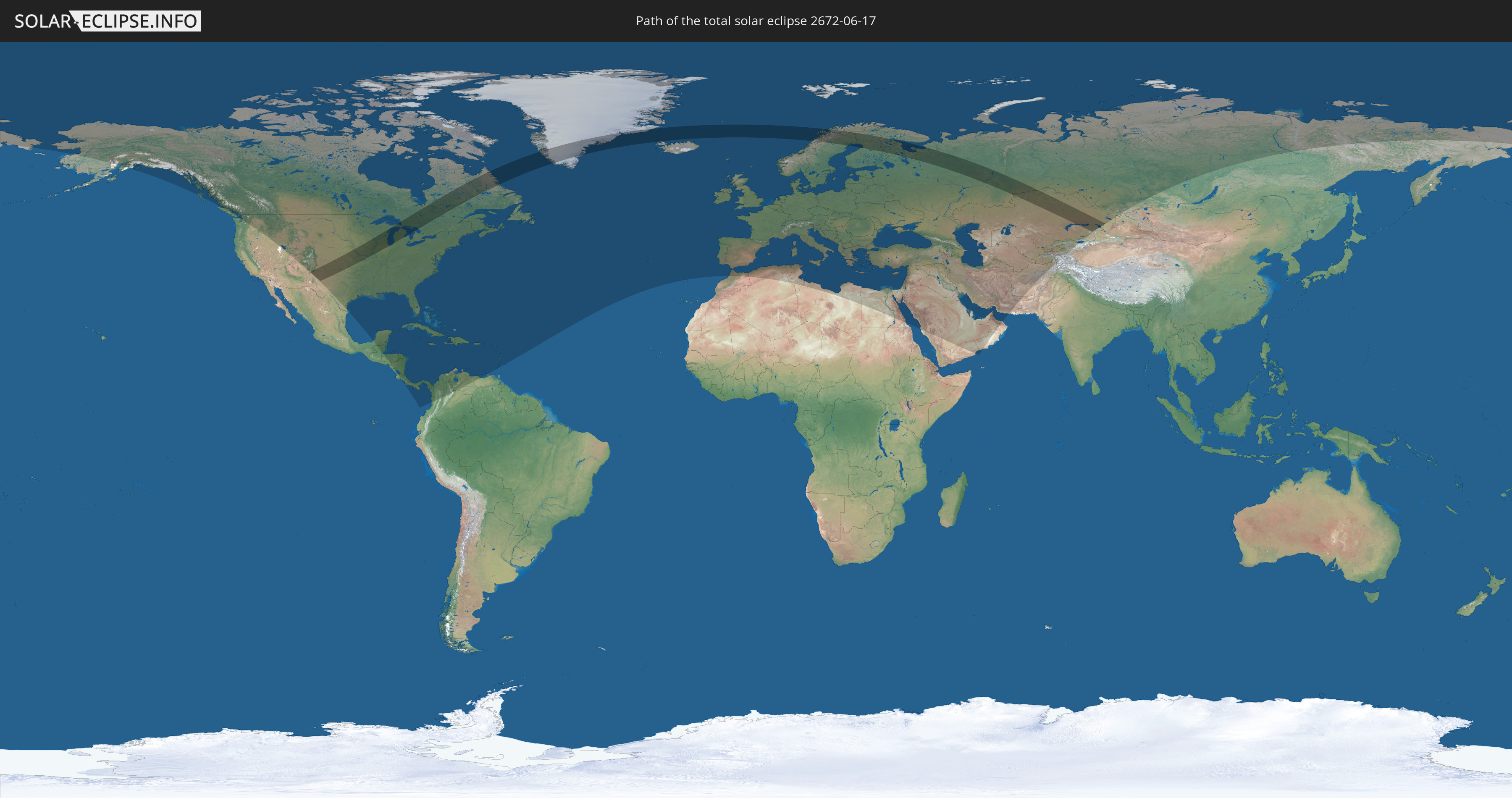
Die Sonnenfinsternis am 17.06.2672 kann man in 121 Ländern als partielle Sonnenfinsternis beobachten.
Der Finsternispfad verläuft durch 10 Länder. Nur in diesen Ländern ist sie als totale Sonnenfinsternis zu sehen.
In den folgenden Ländern ist die Sonnenfinsternis total zu sehen
 Russland
 Vereinigte Staaten
 Kanada
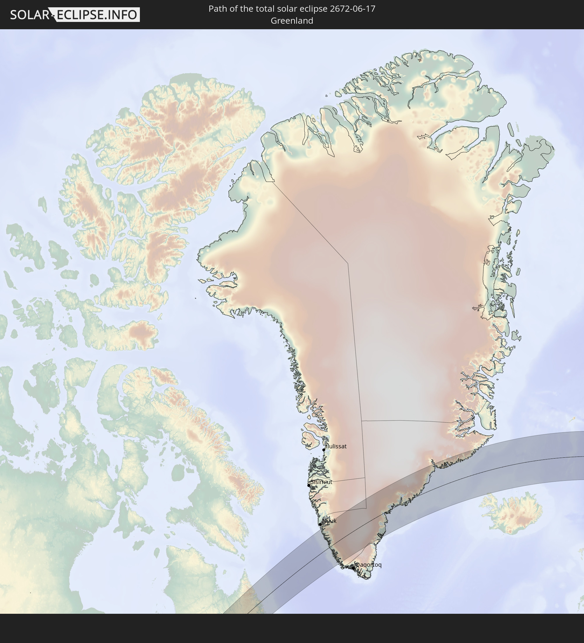 Grönland
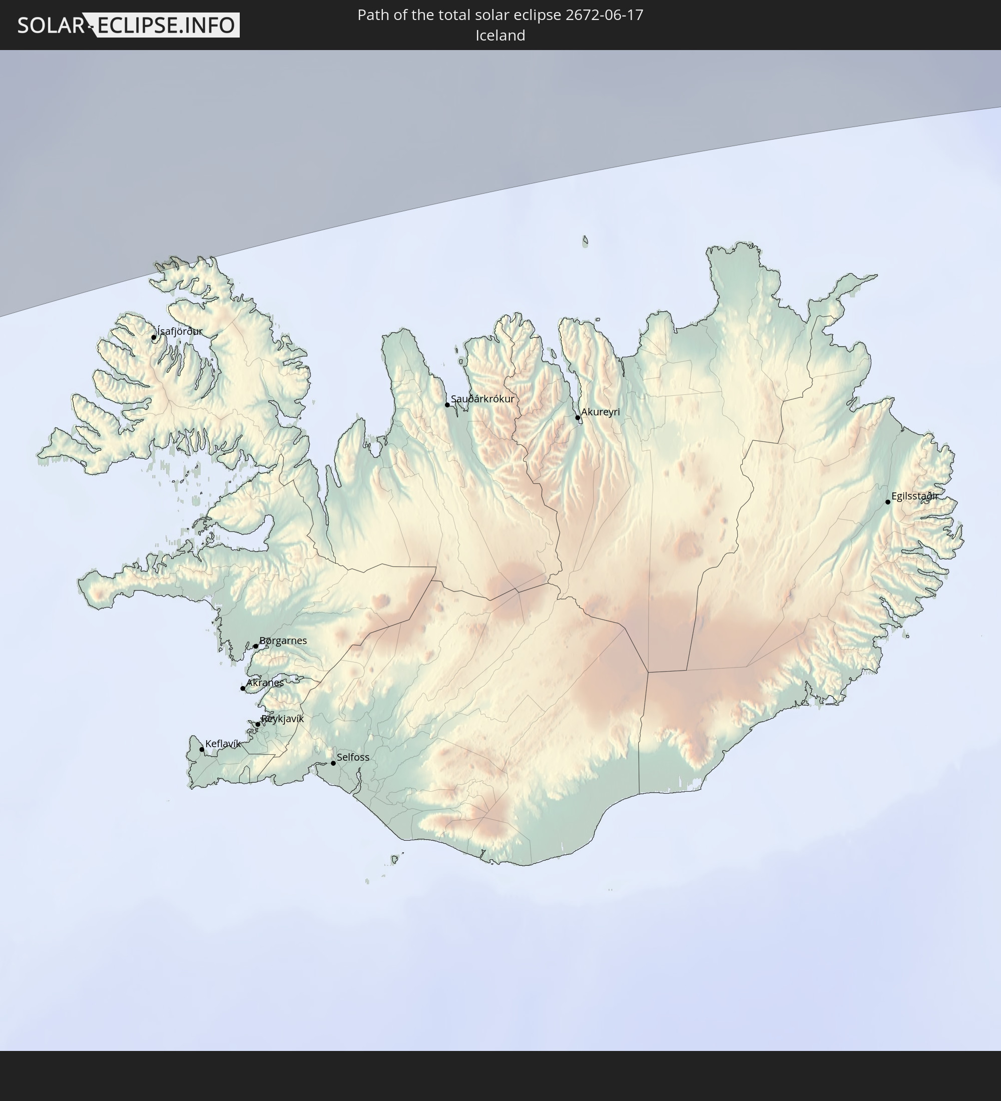 Island
 Norwegen
 Schweden
 Finnland
 Kasachstan
 Volksrepublik China
In den folgenden Ländern ist die Sonnenfinsternis partiell zu sehen
 Russland
 Vereinigte Staaten
 United States Minor Outlying Islands
 Kanada
 Mexiko
 Grönland
 Guatemala
 Honduras
 Belize
 Nicaragua
 Costa Rica
 Kuba
Kuba
 Panama
 Kolumbien
 Kaimaninseln
 Bahamas
 Jamaika
 Haiti
Haiti
 Venezuela
 Turks- und Caicosinseln
 Dominikanische Republik
 Aruba
Aruba
 Puerto Rico
 Amerikanische Jungferninseln
 Bermuda
 Britische Jungferninseln
 Anguilla
 Saint-Martin
 Saint-Barthélemy
 St. Kitts und Nevis
 Antigua und Barbuda
 Montserrat
 Guadeloupe
 Grenada
 Dominica
 St. Vincent und die Grenadinen
 Martinique
 St. Lucia
 Saint-Pierre und Miquelon
 Portugal
 Island
 Spanien
 Marokko
 Irland
 Spitzbergen
 Algerien
 Vereinigtes Königreich
 Färöer
 Gibraltar
 Frankreich
 Isle of Man
 Guernsey
 Jersey
 Andorra
 Belgien
 Niederlande
 Norwegen
 Luxemburg
 Deutschland
 Schweiz
 Italien
 Monaco
 Tunesien
 Dänemark
 Libyen
 Liechtenstein
 Österreich
 Schweden
 Tschechien
 San Marino
 Vatikanstadt
 Slowenien
 Kroatien
 Polen
Polen
 Malta
Malta
 Bosnien und Herzegowina
 Ungarn
 Slowakei
 Montenegro
 Serbien
 Albanien
 Åland Islands
 Griechenland
 Rumänien
 Mazedonien
 Finnland
 Litauen
 Lettland
 Estland
 Ukraine
 Bulgarien
 Weißrussland
 Ägypten
 Türkei
 Moldawien
 Republik Zypern
 Staat Palästina
 Israel
 Saudi-Arabien
 Jordanien
 Libanon
 Syrien
 Irak
Irak
 Georgien
 Jemen
Jemen
 Armenien
 Iran
Iran
 Aserbaidschan
 Kasachstan
 Kuwait
 Bahrain
 Katar
Katar
 Vereinigte Arabische Emirate
 Oman
Oman
 Turkmenistan
 Usbekistan
 Afghanistan
 Pakistan
 Tadschikistan
 Kirgisistan
 Volksrepublik China
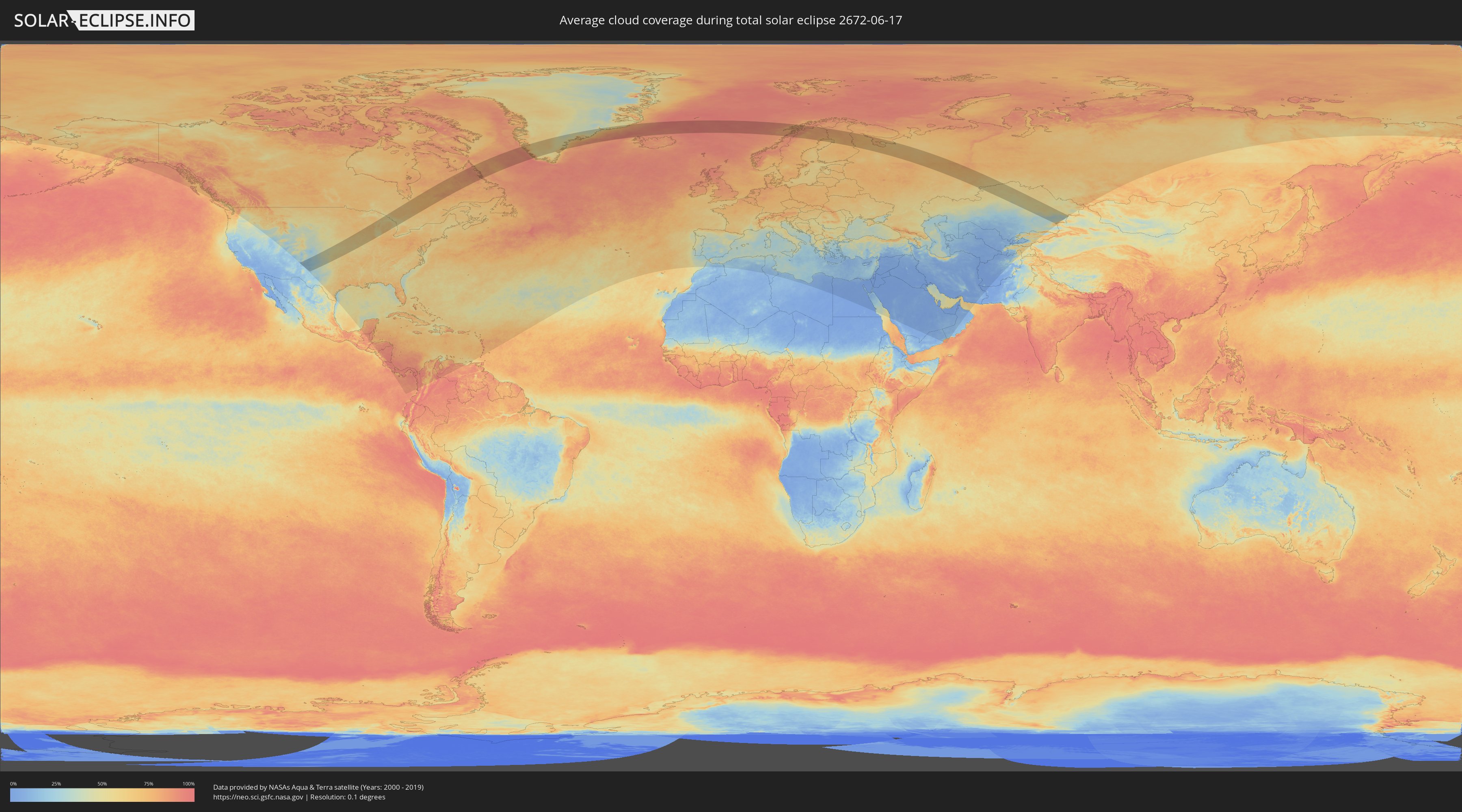
Wie wird das Wetter während der totalen Sonnenfinsternis am 17.06.2672?
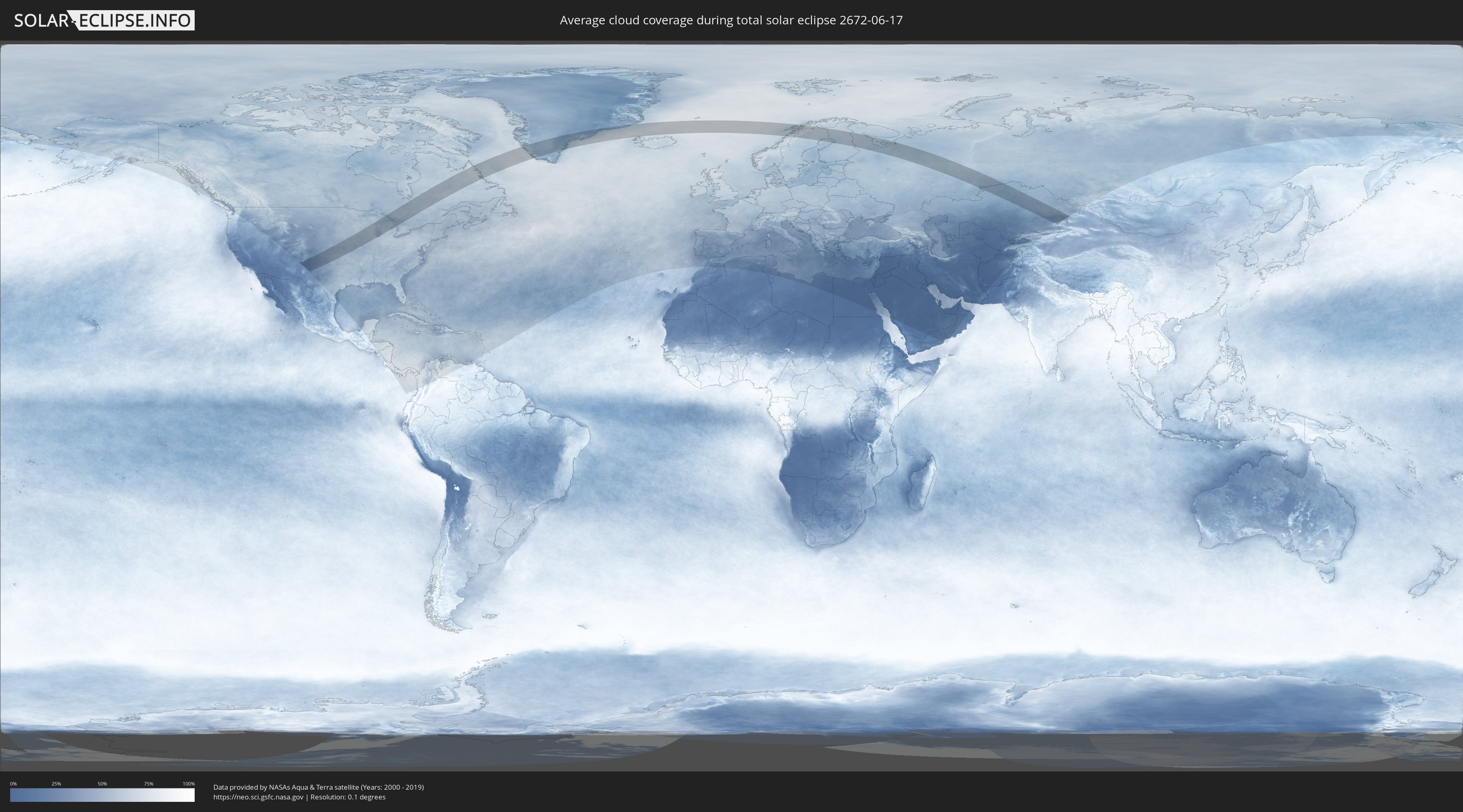
Wo ist der beste Ort, um die totale Sonnenfinsternis vom 17.06.2672 zu beobachten?
Die folgenden Karten zeigen die durchschnittliche Bewölkung für den Tag, an dem die totale Sonnenfinsternis
stattfindet. Mit Hilfe der Karten lässt sich der Ort entlang des Finsternispfades eingrenzen,
der die besten Aussichen auf einen klaren wolkenfreien Himmel bietet.
Trotzdem muss man immer lokale Gegenenheiten beachten und sollte sich genau über das Wetter an seinem
gewählten Beobachtungsort informieren.
Die Daten stammen von den beiden NASA-Satelliten
AQUA und TERRA
und wurden über einen Zeitraum von 19 Jahren (2000 - 2019) gemittelt.
Detaillierte Länderkarten
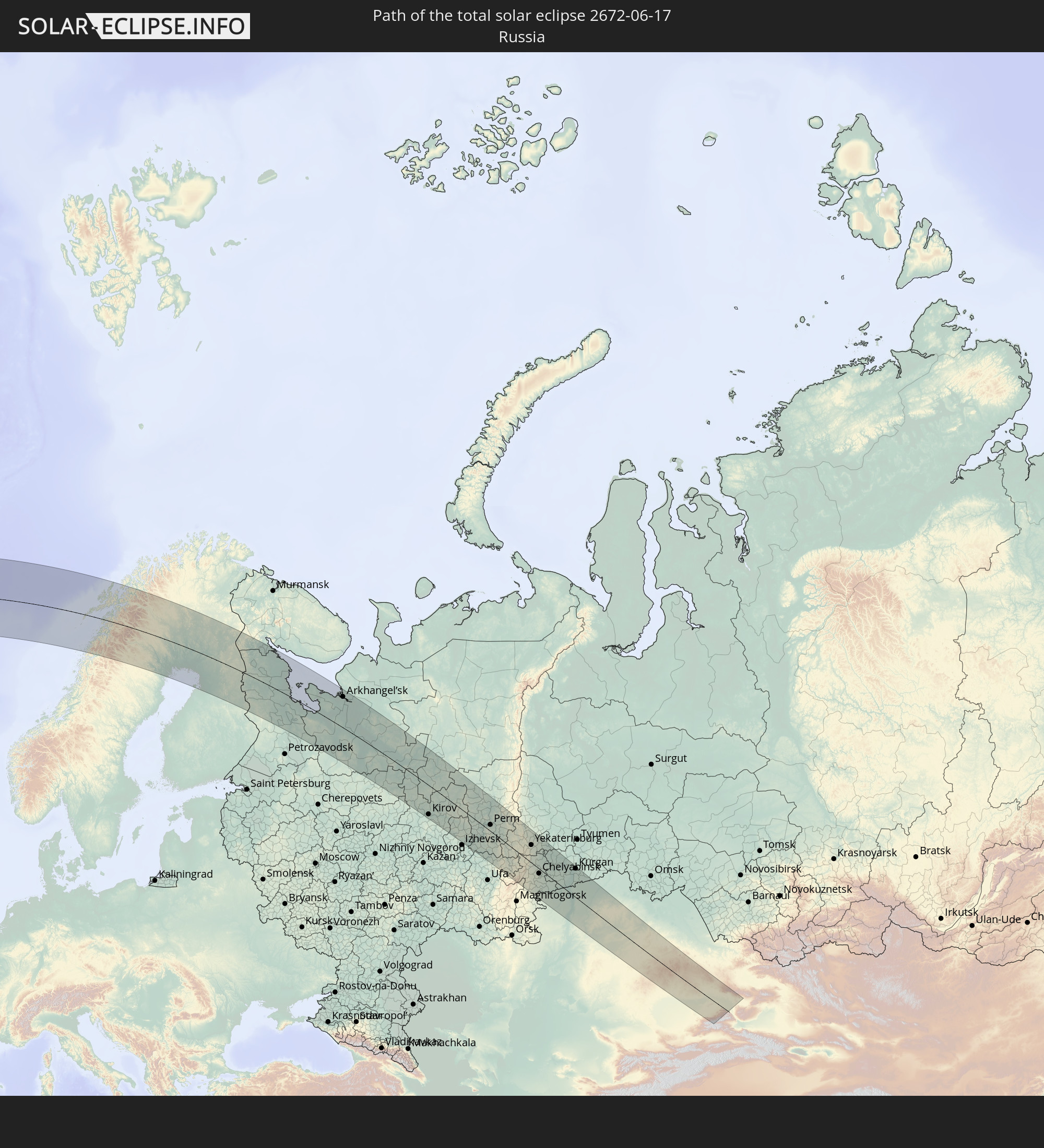
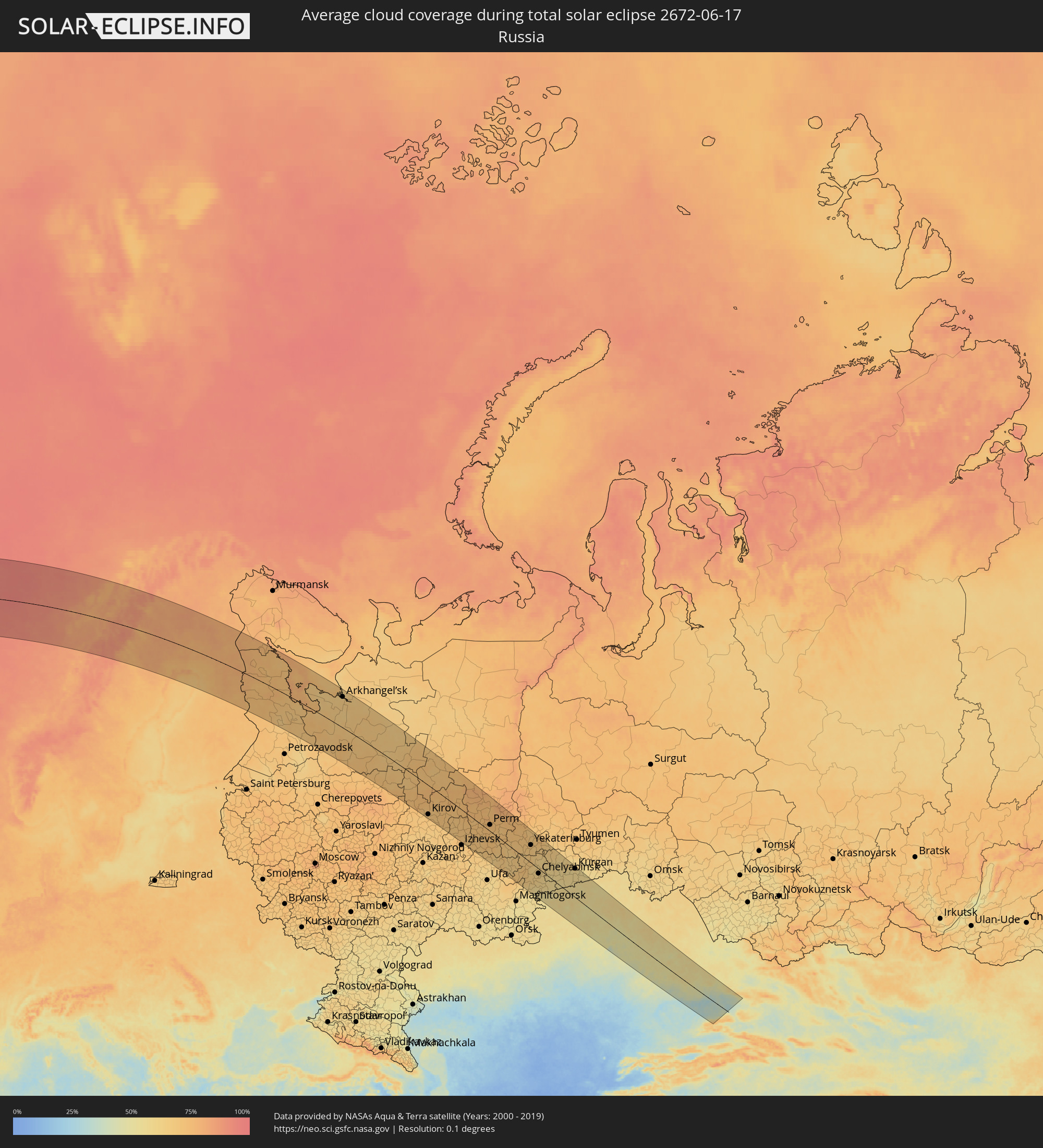 Russland
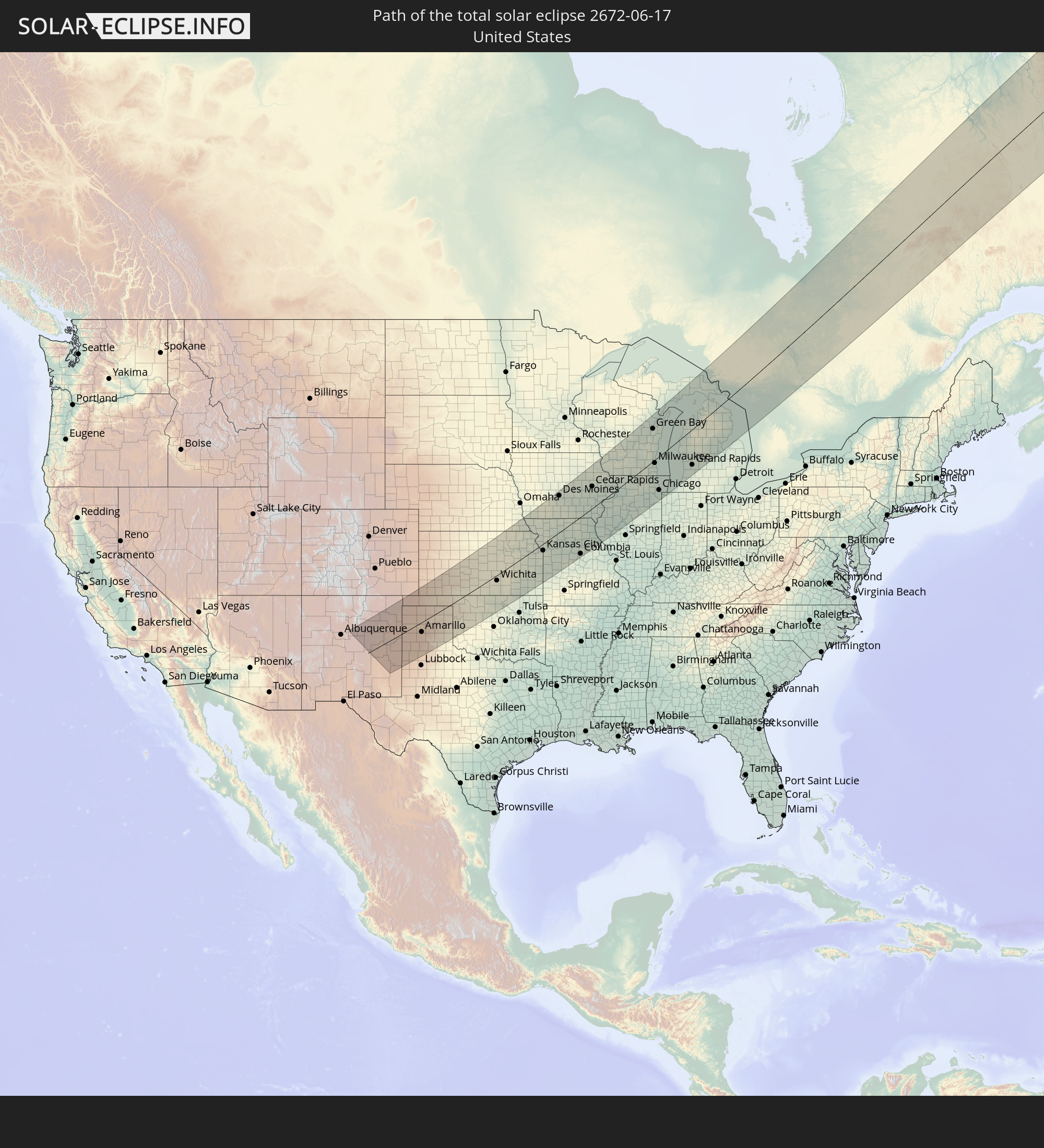
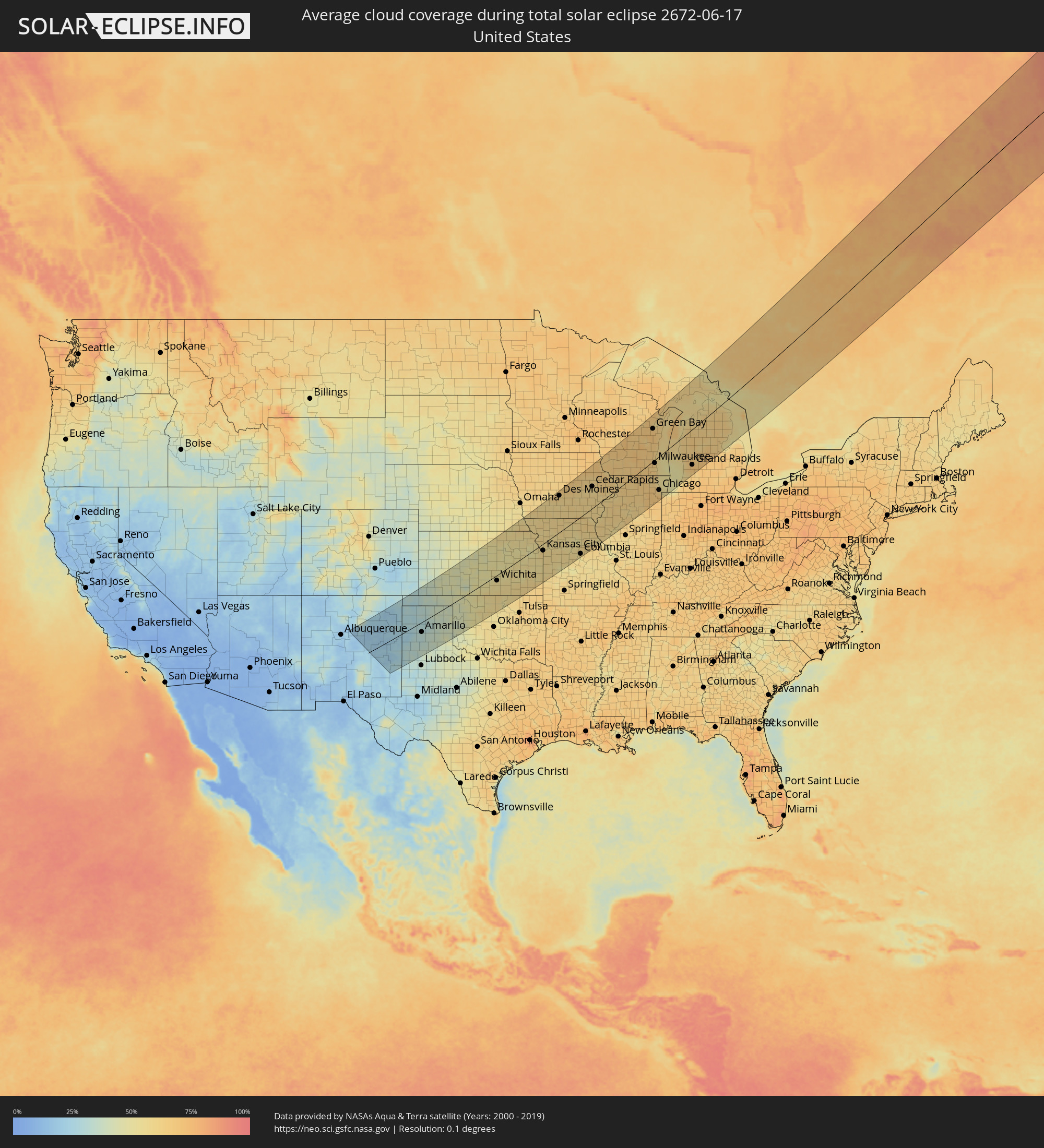 Vereinigte Staaten
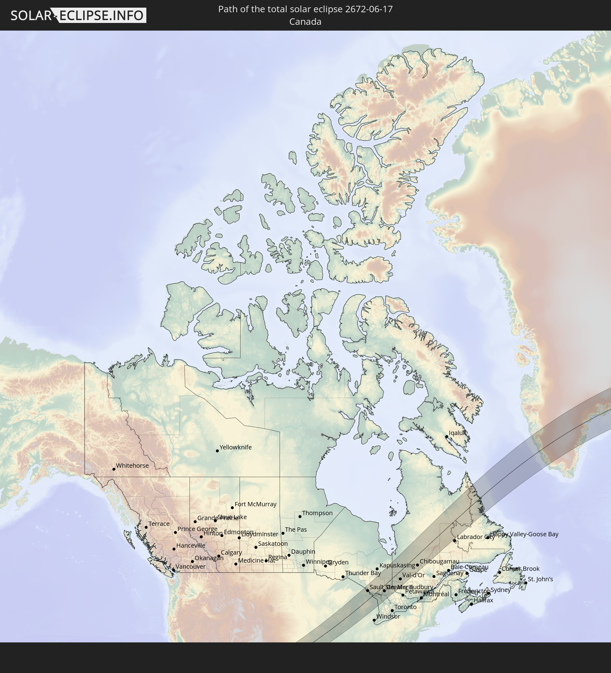
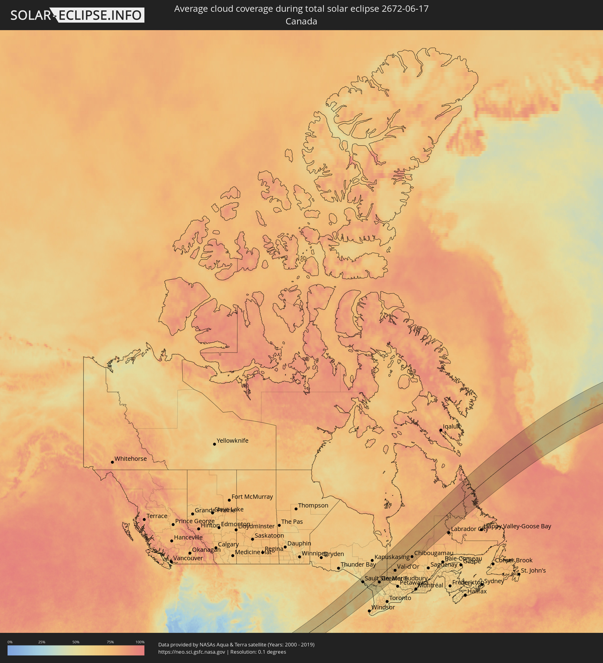 Kanada
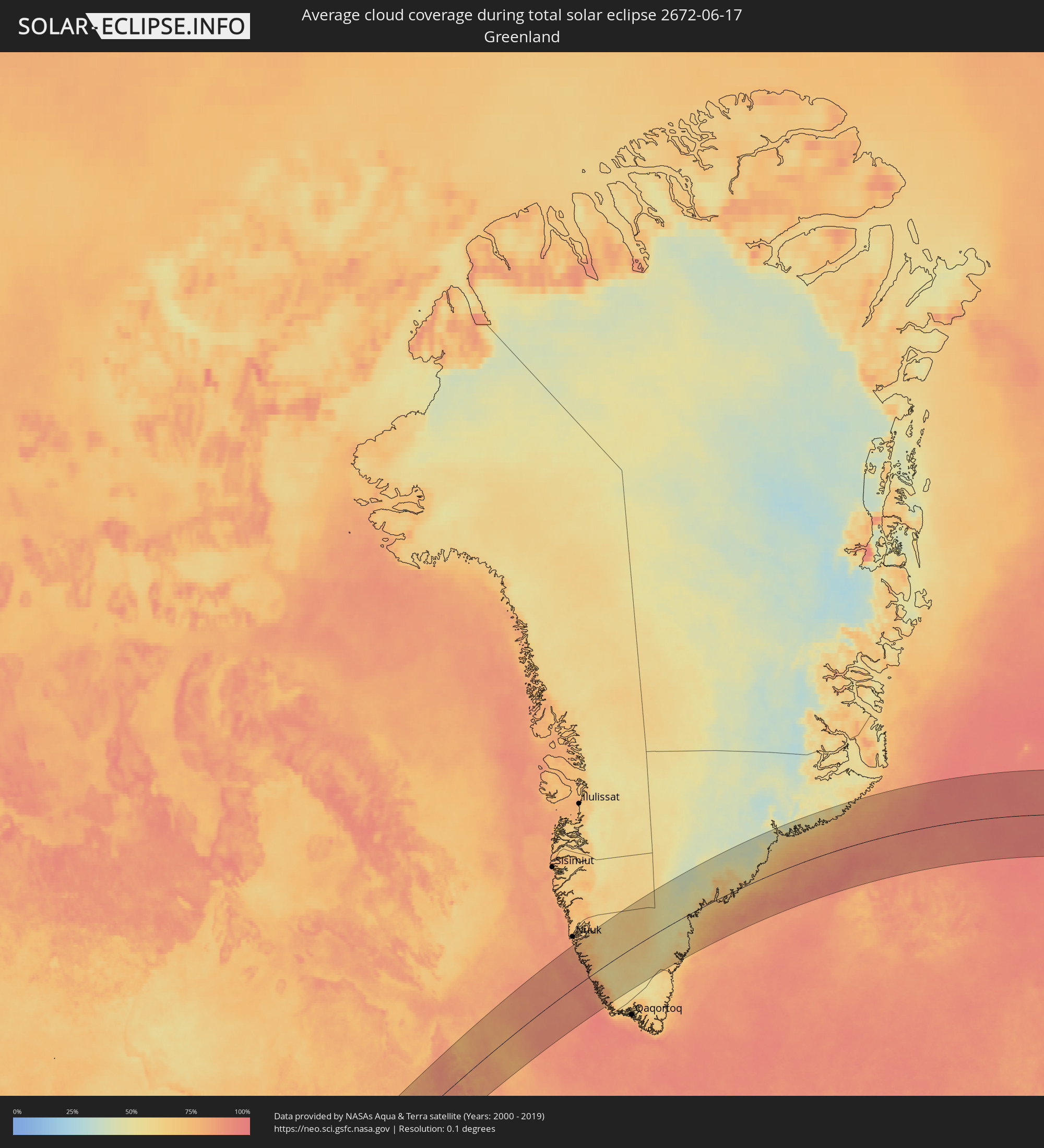 Grönland
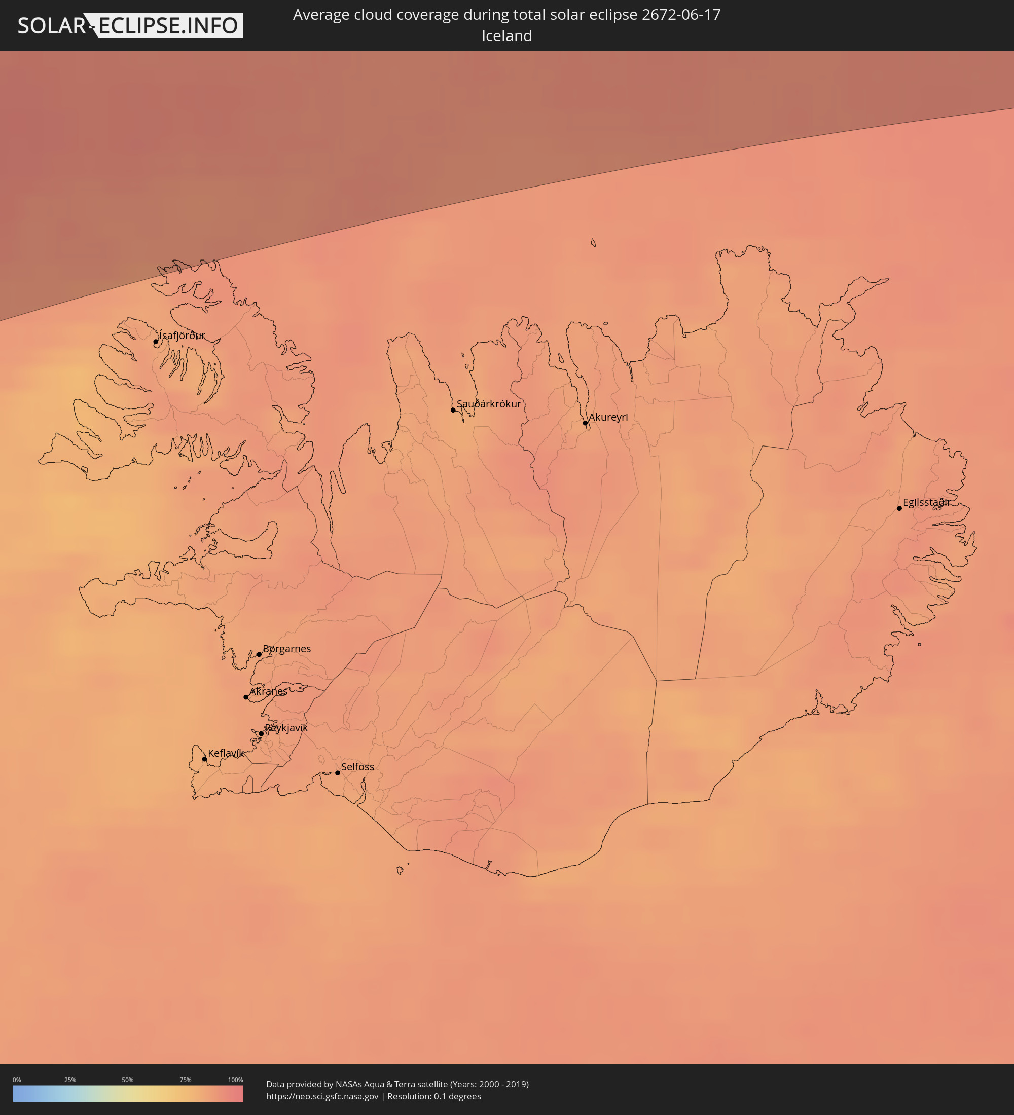 Island
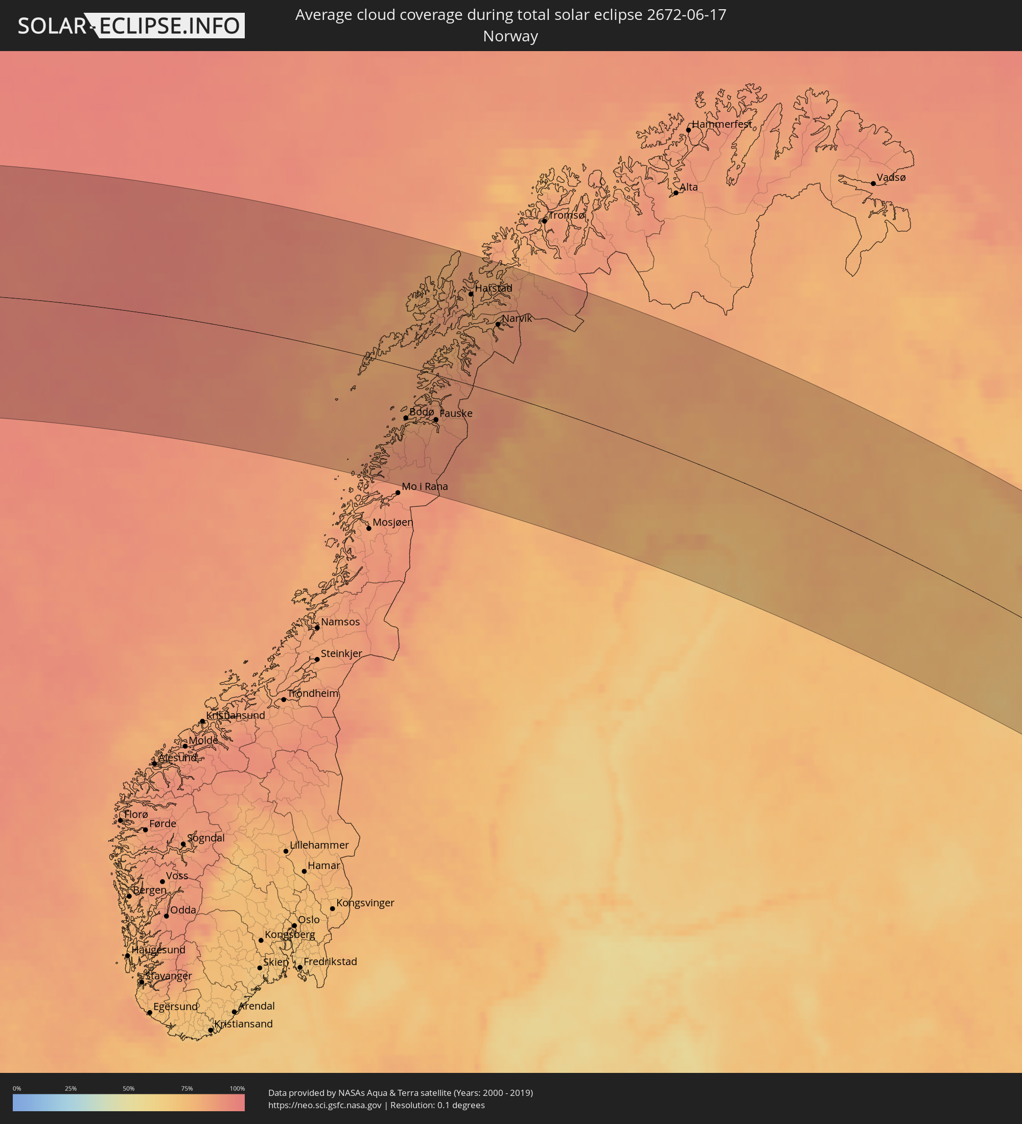 Norwegen
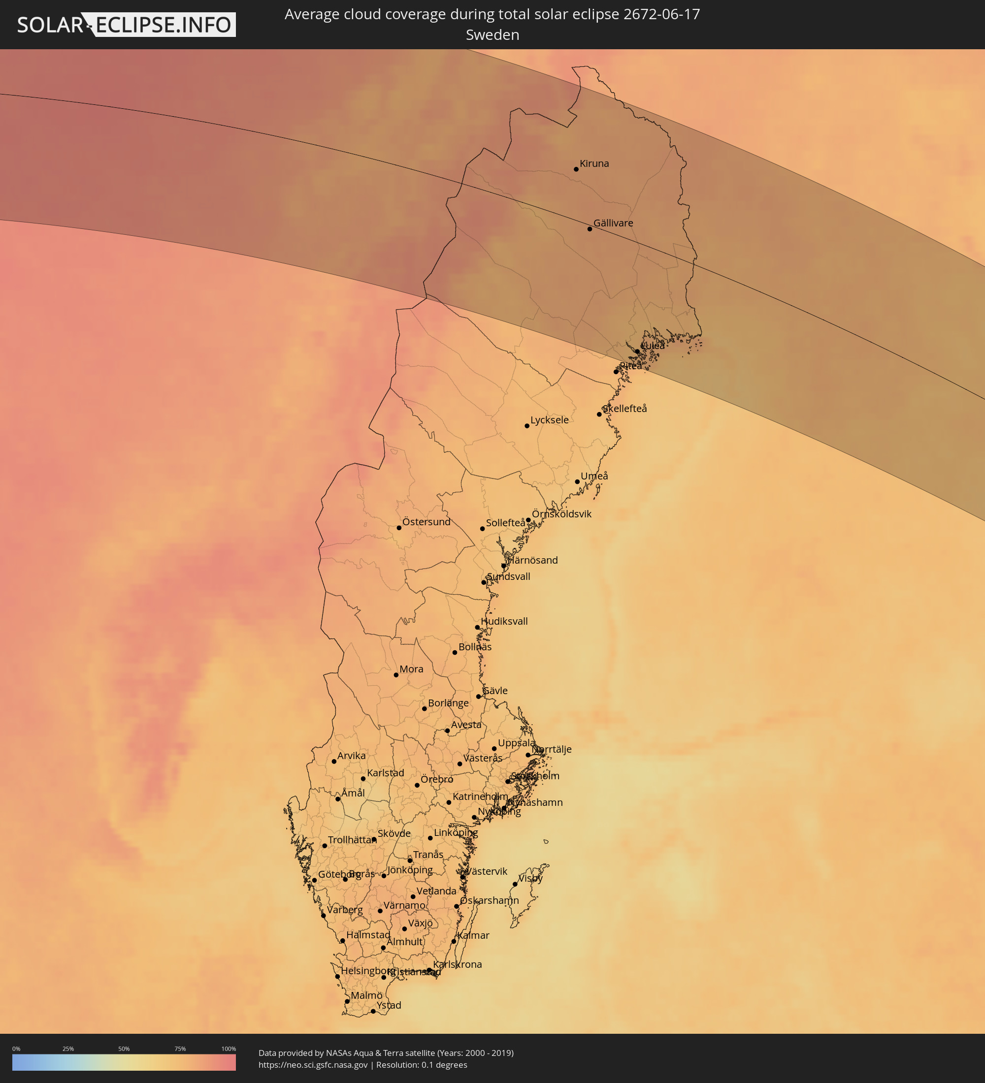 Schweden
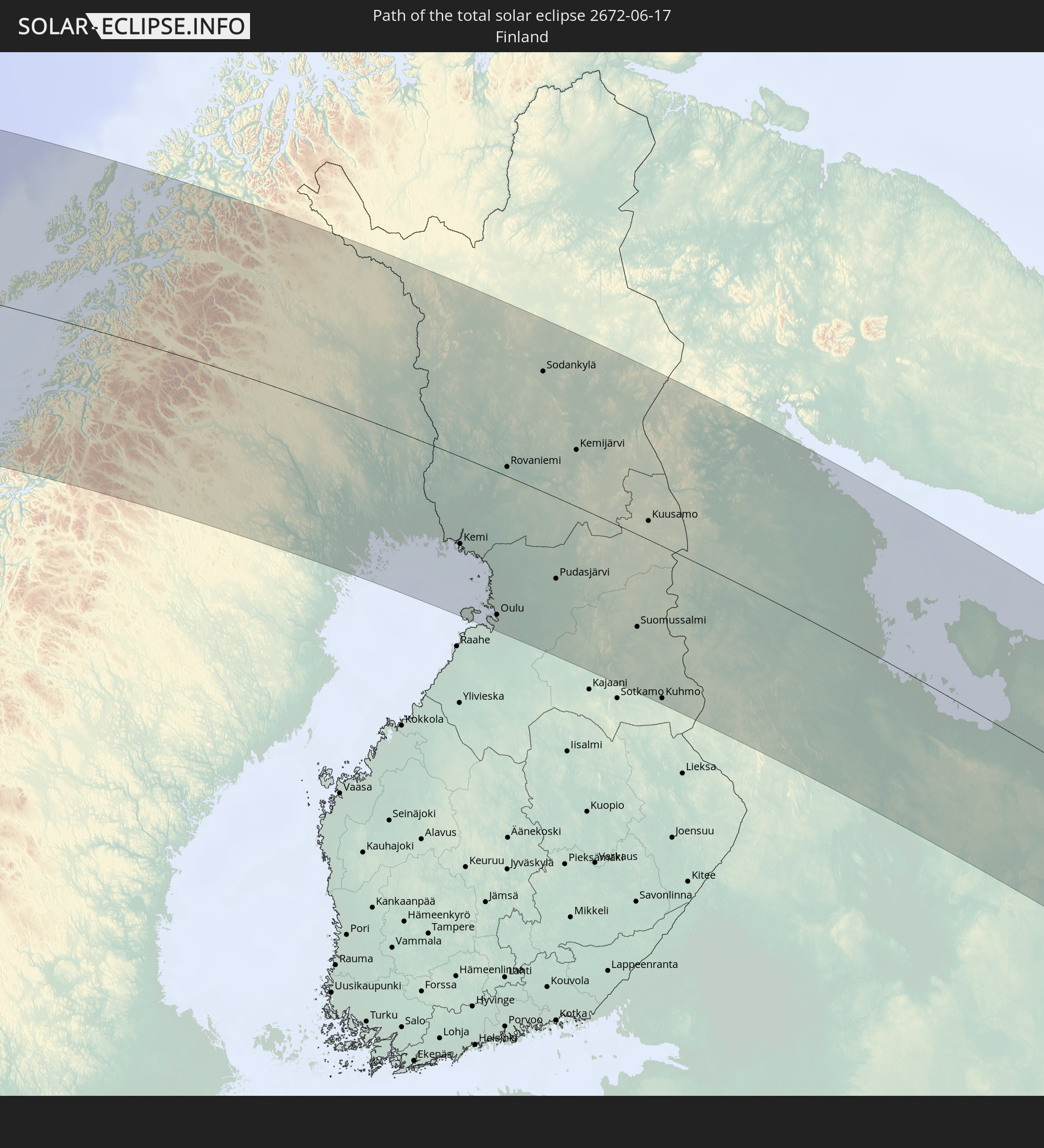
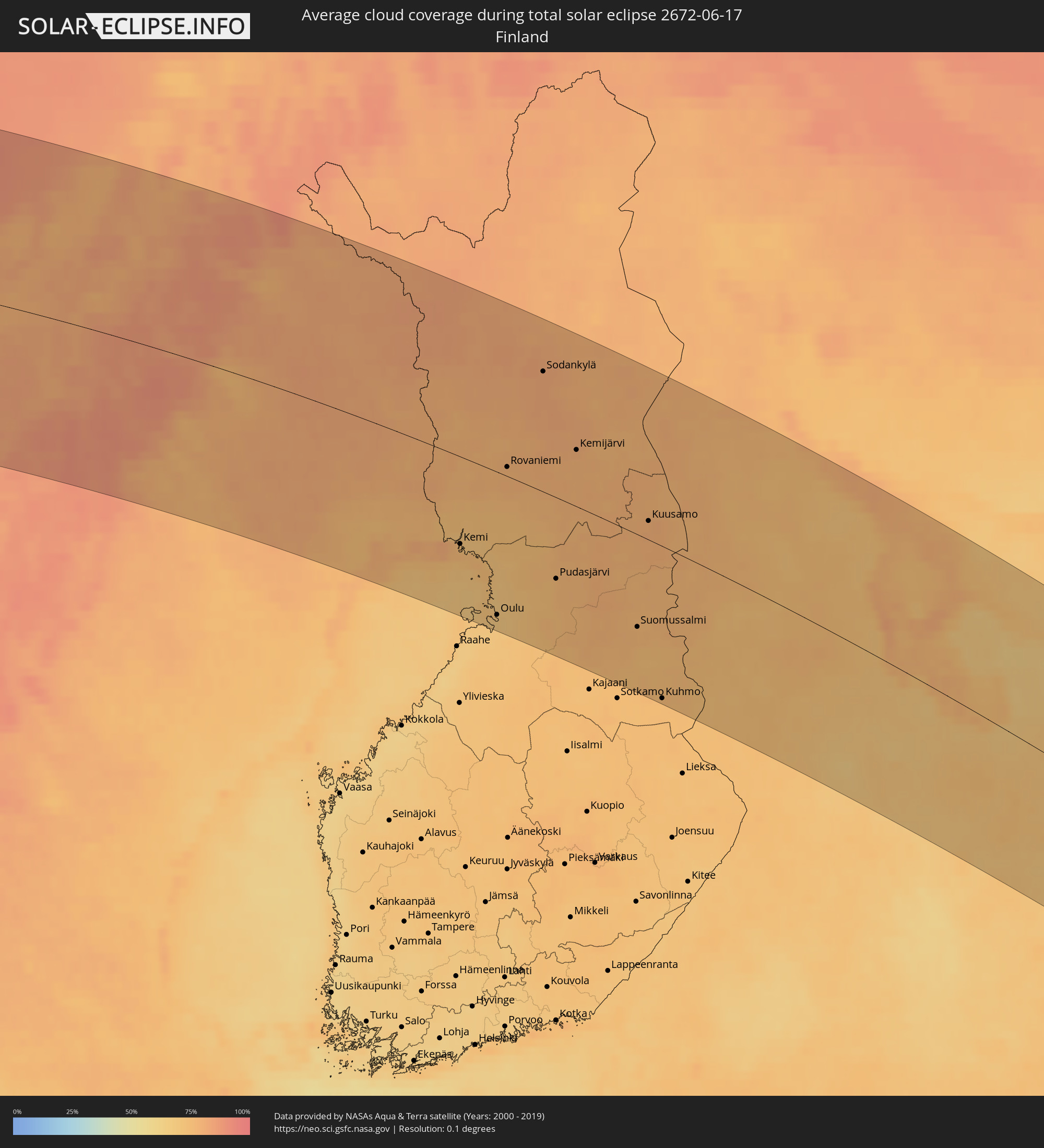 Finnland
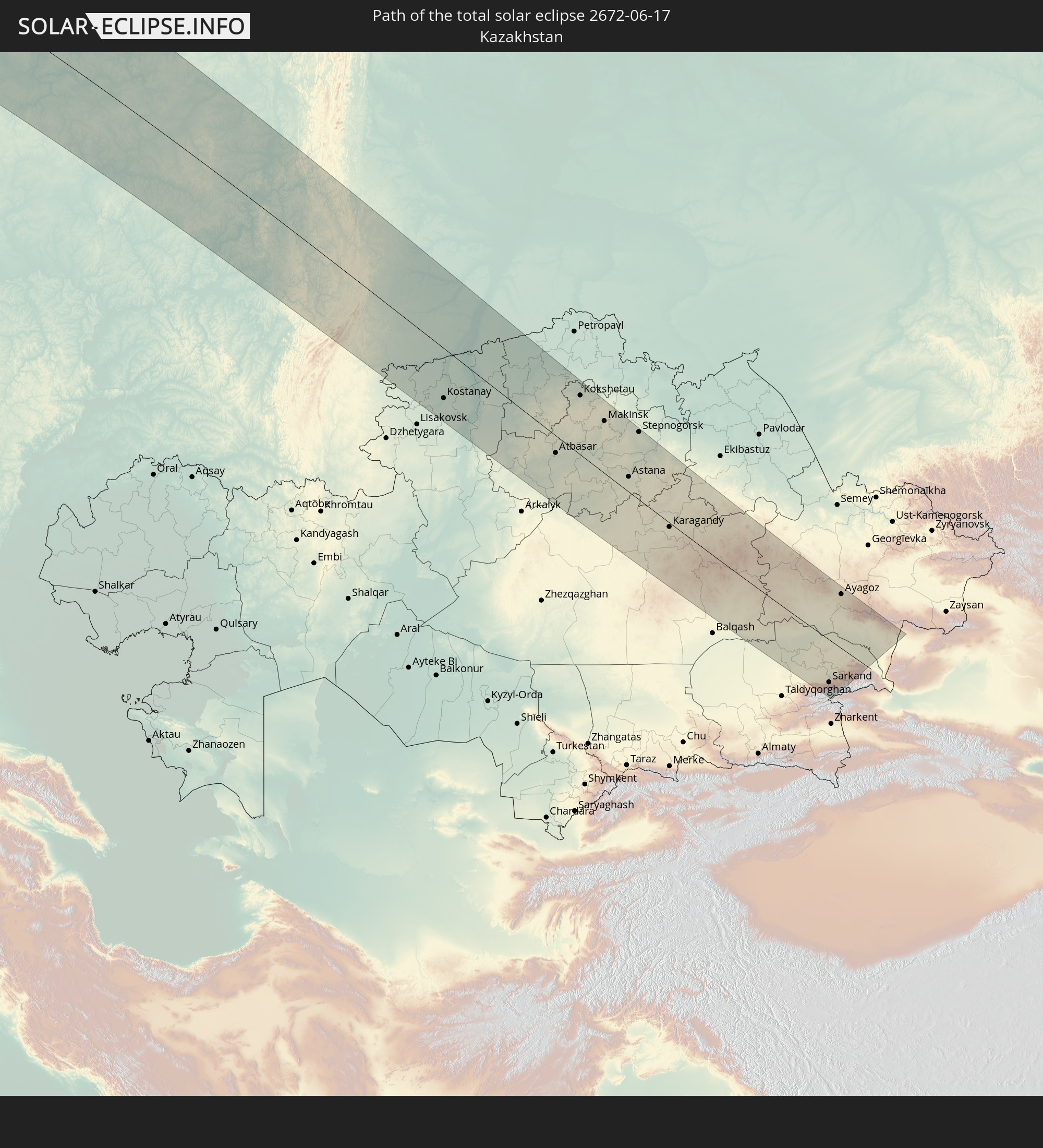
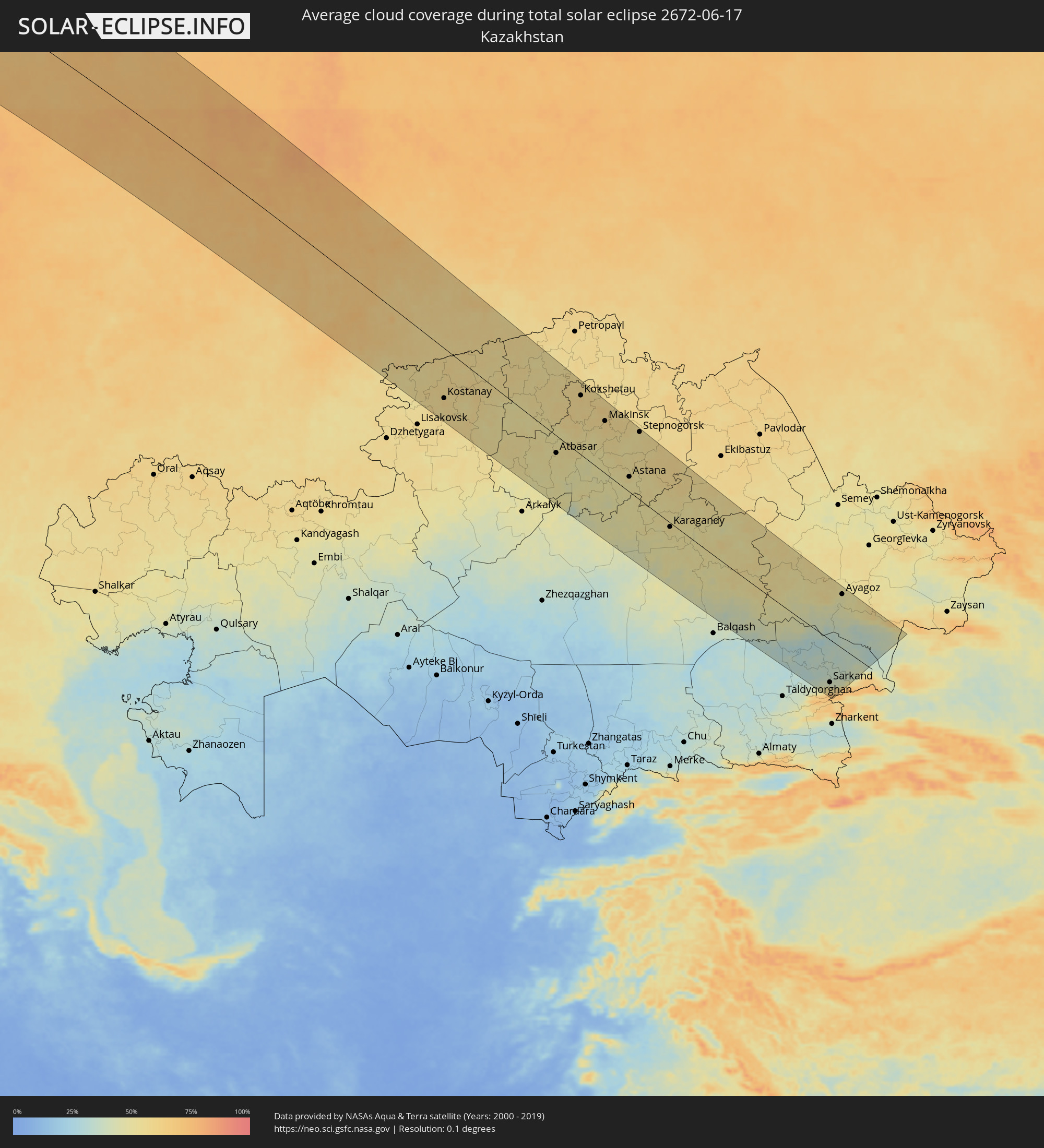 Kasachstan
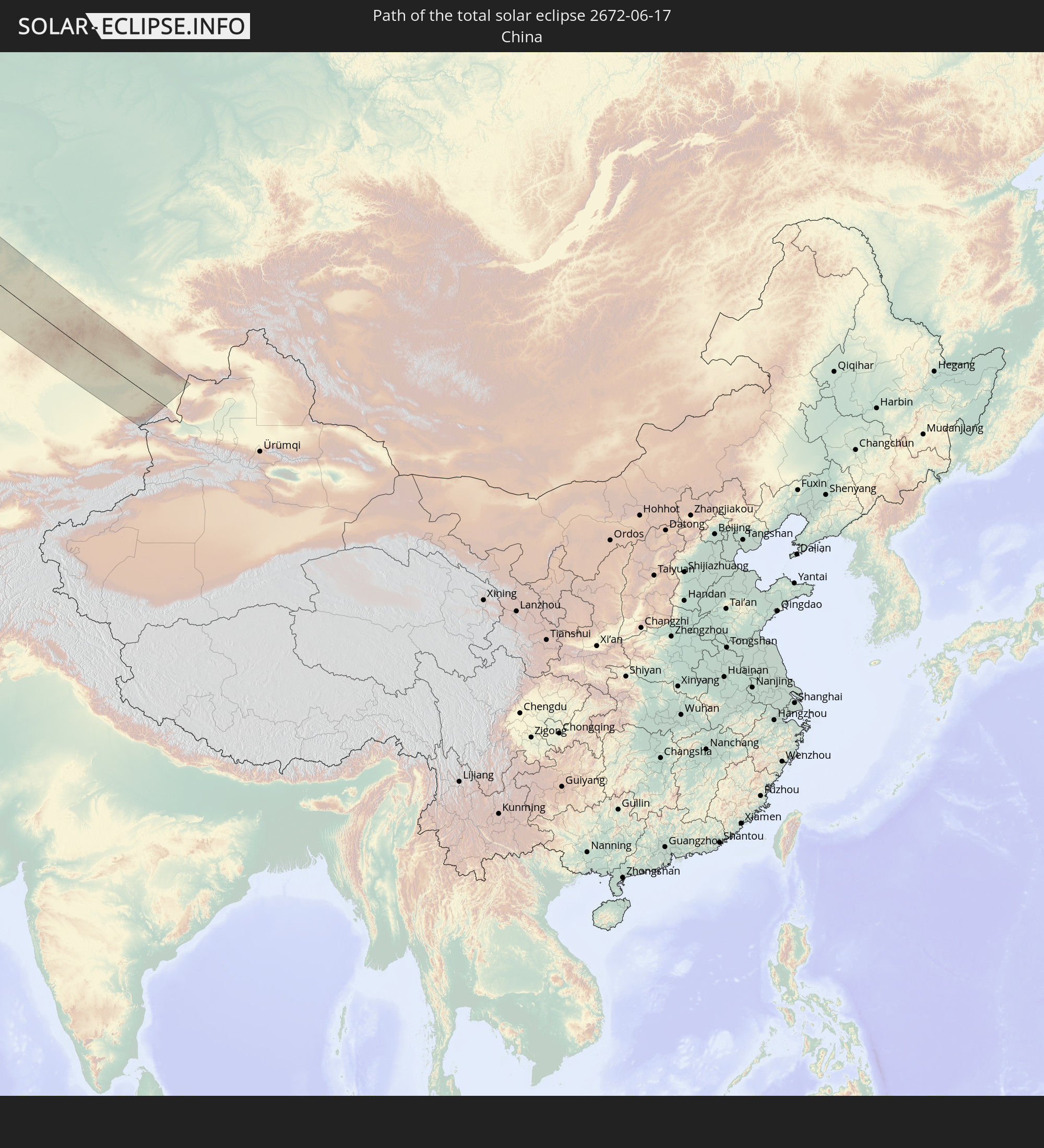
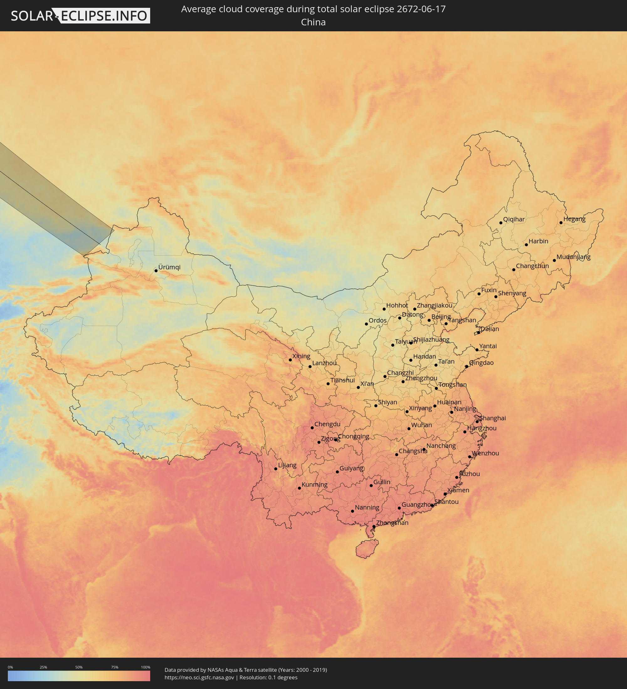 Volksrepublik China
Orte im Finsternispfad
Die nachfolgene Tabelle zeigt Städte und Orte mit mehr als 5.000 Einwohnern, die sich im Finsternispfad befinden. Städte mit mehr als 100.000 Einwohnern sind dick gekennzeichnet. Mit einem Klick auf den Ort öffnet sich eine Detailkarte die die Lage des jeweiligen Ortes zusammen mit dem Verlauf der zentralen Finsternis präsentiert.
| Ort | Typ | Dauer der Verfinsterung | Ortszeit bei maximaler Verfinsterung | Entfernung zur Zentrallinie | Ø Bewölkung |
|
Amarillo, Texas
|
total | - | 05:54:18 UTC-06:00 | 46 km | 33% |
|
Wichita, Kansas
|
total | - | 05:55:33 UTC-06:00 | 24 km | 54% |
|
Topeka, Kansas
|
total | - | 05:56:45 UTC-06:00 | 21 km | 54% |
|
Lawrence, Kansas
|
total | - | 05:56:32 UTC-06:00 | 24 km | 50% |
|
Saint Joseph, Missouri
|
total | - | 05:57:28 UTC-06:00 | 46 km | 58% |
|
Olathe, Kansas
|
total | - | 05:56:18 UTC-06:00 | 37 km | 58% |
|
Overland Park, Kansas
|
total | - | 05:56:24 UTC-06:00 | 36 km | 59% |
|
Kansas City, Missouri
|
total | - | 05:56:32 UTC-06:00 | 38 km | 60% |
|
Lee's Summit, Missouri
|
total | - | 05:56:14 UTC-06:00 | 55 km | 56% |
|
East Independence, Missouri
|
total | - | 05:56:28 UTC-06:00 | 40 km | 59% |
|
Des Moines, Iowa
|
total | - | 05:59:38 UTC-06:00 | 149 km | 62% |
|
Columbia, Missouri
|
total | - | 05:55:47 UTC-06:00 | 154 km | 58% |
|
Cedar Rapids, Iowa
|
total | - | 05:59:49 UTC-06:00 | 87 km | 55% |
|
Davenport, Iowa
|
total | - | 05:58:58 UTC-06:00 | 19 km | 57% |
|
Peoria, Illinois
|
total | - | 05:57:39 UTC-06:00 | 134 km | 62% |
|
Madison, Wisconsin
|
total | - | 06:01:00 UTC-06:00 | 68 km | 63% |
|
Rockford, Illinois
|
total | - | 05:59:49 UTC-06:00 | 31 km | 65% |
|
Aurora, Illinois
|
total | - | 05:59:00 UTC-06:00 | 103 km | 67% |
|
Elgin, Illinois
|
total | - | 05:59:23 UTC-06:00 | 82 km | 64% |
|
Joliet, Illinois
|
total | - | 05:58:38 UTC-06:00 | 136 km | 68% |
|
Green Bay, Wisconsin
|
total | - | 06:02:59 UTC-06:00 | 122 km | 69% |
|
Arlington Heights, Illinois
|
total | - | 05:59:26 UTC-06:00 | 93 km | 66% |
|
Milwaukee, Wisconsin
|
total | - | 06:00:48 UTC-06:00 | 12 km | 64% |
|
Waukegan, Illinois
|
total | - | 05:59:49 UTC-06:00 | 75 km | 59% |
|
Kenosha, Wisconsin
|
total | - | 06:00:08 UTC-06:00 | 56 km | 61% |
|
Racine, Wisconsin
|
total | - | 06:00:20 UTC-06:00 | 46 km | 61% |
|
Chicago, Illinois
|
total | - | 05:59:03 UTC-06:00 | 130 km | 63% |
|
Hammond, Indiana
|
total | - | 05:58:39 UTC-06:00 | 162 km | 68% |
|
Grand Rapids, Michigan
|
total | - | 07:00:32 UTC-05:00 | 134 km | 68% |
|
Sault Ste. Marie, Ontario
|
total | - | 07:05:55 UTC-05:00 | 103 km | 53% |
|
Elliot Lake, Ontario
|
total | - | 07:05:47 UTC-05:00 | 10 km | 59% |
|
Timmins, Ontario
|
total | - | 07:09:12 UTC-05:00 | 114 km | 67% |
|
Rayside-Balfour, Ontario
|
total | - | 07:06:14 UTC-05:00 | 48 km | 64% |
|
Greater Sudbury, Ontario
|
total | - | 07:06:04 UTC-05:00 | 68 km | 63% |
|
Kirkland Lake, Ontario
|
total | - | 07:08:49 UTC-05:00 | 28 km | 69% |
|
Temiskaming Shores, Ontario
|
total | - | 07:07:48 UTC-05:00 | 49 km | 65% |
|
North Bay, Ontario
|
total | - | 07:05:57 UTC-05:00 | 159 km | 58% |
|
La Sarre, Quebec
|
total | - | 07:10:00 UTC-05:00 | 37 km | 66% |
|
Rouyn-Noranda, Quebec
|
total | - | 07:09:06 UTC-05:00 | 29 km | 67% |
|
Amos, Quebec
|
total | - | 07:09:47 UTC-05:00 | 38 km | 68% |
|
Val-d'Or, Quebec
|
total | - | 07:09:04 UTC-05:00 | 93 km | 71% |
|
Chibougamau, Quebec
|
total | - | 07:12:50 UTC-05:00 | 109 km | 75% |
|
Bodø, Nordland
|
total | - | 14:41:43 UTC+01:00 | 70 km | 80% |
|
Fauske, Nordland
|
total | - | 14:42:22 UTC+01:00 | 61 km | 83% |
|
Harstad, Troms
|
total | - | 14:41:18 UTC+01:00 | 118 km | 80% |
|
Narvik, Nordland
|
total | - | 14:42:14 UTC+01:00 | 90 km | 84% |
|
Kiruna, Norrbotten
|
total | - | 14:44:31 UTC+01:00 | 65 km | 82% |
|
Gällivare, Norrbotten
|
total | - | 14:45:40 UTC+01:00 | 11 km | 82% |
|
Malmberget, Norrbotten
|
total | - | 14:45:36 UTC+01:00 | 8 km | 81% |
|
Älvsbyn, Norrbotten
|
total | - | 14:47:44 UTC+01:00 | 154 km | 76% |
|
Boden, Norrbotten
|
total | - | 14:47:56 UTC+01:00 | 127 km | 75% |
|
Luleå, Norrbotten
|
total | - | 14:48:31 UTC+01:00 | 145 km | 76% |
|
Kalix, Norrbotten
|
total | - | 14:48:44 UTC+01:00 | 101 km | 76% |
|
Ylitornio, Lapland
|
total | - | 15:48:25 UTC+02:00 | 45 km | 79% |
|
Tornio, Lapland
|
total | - | 15:49:18 UTC+02:00 | 85 km | 81% |
|
Keminmaa, Lapland
|
total | - | 15:49:34 UTC+02:00 | 84 km | 74% |
|
Kemi, Lapland
|
total | - | 15:49:40 UTC+02:00 | 90 km | 75% |
|
Kittilä, Lapland
|
total | - | 15:47:13 UTC+02:00 | 115 km | 80% |
|
Haukipudas, Northern Ostrobothnia
|
total | - | 15:50:52 UTC+02:00 | 133 km | 68% |
|
Ii, Northern Ostrobothnia
|
total | - | 15:50:41 UTC+02:00 | 118 km | 68% |
|
Oulunsalo, Northern Ostrobothnia
|
total | - | 15:51:14 UTC+02:00 | 157 km | 68% |
|
Oulu, Northern Ostrobothnia
|
total | - | 15:51:10 UTC+02:00 | 148 km | 68% |
|
Kempele, Northern Ostrobothnia
|
total | - | 15:51:19 UTC+02:00 | 158 km | 69% |
|
Rovaniemi, Lapland
|
total | - | 15:49:14 UTC+02:00 | 11 km | 77% |
|
Kiiminki, Northern Ostrobothnia
|
total | - | 15:51:10 UTC+02:00 | 130 km | 69% |
|
Muhos, Northern Ostrobothnia
|
total | - | 15:51:44 UTC+02:00 | 159 km | 71% |
|
Sodankylä, Lapland
|
total | - | 15:48:24 UTC+02:00 | 118 km | 81% |
|
Pudasjärvi, Northern Ostrobothnia
|
total | - | 15:51:24 UTC+02:00 | 84 km | 75% |
|
Pyhäjärvi, Lapland
|
total | - | 15:49:10 UTC+02:00 | 94 km | 80% |
|
Kemijärvi, Lapland
|
total | - | 15:49:50 UTC+02:00 | 57 km | 79% |
|
Suomussalmi, Kainuu
|
total | - | 15:53:07 UTC+02:00 | 96 km | 76% |
|
Kuusamo, Northern Ostrobothnia
|
total | - | 15:51:41 UTC+02:00 | 19 km | 79% |
|
Kuhmo, Kainuu
|
total | - | 15:54:31 UTC+02:00 | 159 km | 74% |
|
Severodvinsk, Arkhangelskaya
|
total | - | 16:58:02 UTC+03:00 | 121 km | 67% |
|
Arkhangel’sk, Arkhangelskaya
|
total | - | 16:58:17 UTC+03:00 | 137 km | 66% |
|
Kotlas, Arkhangelskaya
|
total | - | 17:05:06 UTC+03:00 | 8 km | 67% |
|
Kirov, Kirov
|
total | - | 17:09:50 UTC+03:00 | 144 km | 70% |
|
Kirovo-Chepetsk, Kirov
|
total | - | 17:09:58 UTC+03:00 | 135 km | 70% |
|
Glazov, Udmurtiya
|
total | - | 18:10:56 UTC+04:00 | 83 km | 70% |
|
Votkinsk, Udmurtiya
|
total | - | 18:12:43 UTC+04:00 | 135 km | 68% |
|
Chaykovskiy, Perm
|
total | - | 19:13:09 UTC+05:00 | 156 km | 72% |
|
Krasnokamsk, Perm
|
total | - | 19:11:15 UTC+05:00 | 21 km | 73% |
|
Perm, Perm
|
total | - | 19:11:22 UTC+05:00 | 32 km | 75% |
|
Kungur, Perm
|
total | - | 19:12:15 UTC+05:00 | 11 km | 72% |
|
Lys’va, Perm
|
total | - | 19:11:15 UTC+05:00 | 98 km | 74% |
|
Chusovoy, Perm
|
total | - | 19:10:58 UTC+05:00 | 114 km | 75% |
|
Satka, Chelyabinsk
|
total | - | 19:15:47 UTC+05:00 | 129 km | 69% |
|
Zlatoust, Chelyabinsk
|
total | - | 19:15:34 UTC+05:00 | 93 km | 69% |
|
Pervoural’sk, Sverdlovsk
|
total | - | 19:13:01 UTC+05:00 | 73 km | 71% |
|
Nizhniy Tagil, Sverdlovsk
|
total | - | 19:11:31 UTC+05:00 | 161 km | 73% |
|
Novoural’sk, Sverdlovsk
|
total | - | 19:12:31 UTC+05:00 | 106 km | 70% |
|
Miass, Chelyabinsk
|
total | - | 19:15:44 UTC+05:00 | 86 km | 68% |
|
Polevskoy, Sverdlovsk
|
total | - | 19:13:41 UTC+05:00 | 43 km | 66% |
|
Yekaterinburg, Sverdlovsk
|
total | - | 19:13:04 UTC+05:00 | 93 km | 74% |
|
Ozersk, Chelyabinsk
|
total | - | 19:14:40 UTC+05:00 | 17 km | 68% |
|
Snezhinsk, Chelyabinsk
|
total | - | 19:14:11 UTC+05:00 | 30 km | 68% |
|
Chelyabinsk, Chelyabinsk
|
total | - | 19:15:29 UTC+05:00 | 29 km | 66% |
|
Asbest, Sverdlovsk
|
total | - | 19:12:48 UTC+05:00 | 138 km | 73% |
|
Troitsk, Chelyabinsk
|
total | - | 19:16:58 UTC+05:00 | 113 km | 59% |
|
Kamensk-Ural’skiy, Sverdlovsk
|
total | - | 19:13:37 UTC+05:00 | 105 km | 67% |
|
Komsomolets, Qostanay
|
total | - | 19:17:25 UTC+05:00 | 126 km | 54% |
|
Fedorovka, Qostanay
|
total | - | 19:17:30 UTC+05:00 | 111 km | 55% |
|
Kachar, Qostanay
|
total | - | 19:17:52 UTC+05:00 | 126 km | 58% |
|
Rudnyy, Qostanay
|
total | - | 19:18:23 UTC+05:00 | 152 km | 59% |
|
Kostanay, Qostanay
|
total | - | 19:17:59 UTC+05:00 | 110 km | 60% |
|
Shadrinsk, Kurgan
|
total | - | 19:13:57 UTC+05:00 | 143 km | 62% |
|
Borovskoy, Qostanay
|
total | - | 19:17:06 UTC+05:00 | 36 km | 56% |
|
Qusmuryn, Qostanay
|
total | - | 19:18:53 UTC+05:00 | 138 km | 56% |
|
Kurgan, Kurgan
|
total | - | 19:14:39 UTC+05:00 | 155 km | 63% |
|
Esil, Aqmola
|
total | - | 19:19:14 UTC+05:00 | 108 km | 54% |
|
Sergeyevka, Soltüstik Qazaqstan
|
total | - | 19:16:28 UTC+05:00 | 103 km | 54% |
|
Atbasar, Aqmola
|
total | - | 19:19:01 UTC+05:00 | 40 km | 52% |
|
Kokshetau, Aqmola
|
total | - | 19:16:52 UTC+05:00 | 133 km | 60% |
|
Akkol’, Aqmola
|
total | - | 19:16:48 UTC+05:00 | 143 km | 57% |
|
Shchuchinsk, Aqmola
|
total | - | 19:17:08 UTC+05:00 | 136 km | 59% |
|
Makinsk, Aqmola
|
total | - | 19:17:28 UTC+05:00 | 119 km | 58% |
|
Astana, Astana Qalasy
|
total | - | 19:19:03 UTC+05:00 | 38 km | 56% |
|
Stepnogorsk, Aqmola
|
total | - | 19:17:27 UTC+05:00 | 157 km | 54% |
|
Osakarovka, Qaraghandy
|
total | - | 19:19:29 UTC+05:00 | 33 km | 51% |
|
Shakhan, Qaraghandy
|
total | - | 19:20:21 UTC+05:00 | 34 km | 49% |
|
Sorang, Qaraghandy
|
total | - | 19:20:20 UTC+05:00 | 29 km | 49% |
|
Abay, Qaraghandy
|
total | - | 19:20:31 UTC+05:00 | 45 km | 49% |
|
Aqtas, Qaraghandy
|
total | - | 19:20:18 UTC+05:00 | 28 km | 51% |
|
Temirtau, Qaraghandy
|
total | - | 19:19:59 UTC+05:00 | 4 km | 54% |
|
Aqtaū, Qaraghandy
|
total | - | 19:19:43 UTC+05:00 | 24 km | 52% |
|
Yereymentau, Aqmola
|
total | - | 19:18:01 UTC+05:00 | 146 km | 58% |
|
Karagandy, Qaraghandy
|
total | - | 19:20:11 UTC+05:00 | 25 km | 52% |
|
Qarqaraly, Qaraghandy
|
total | - | 19:19:54 UTC+05:00 | 53 km | 55% |
|
Sarkand, Almaty Oblysy
|
total | - | 19:22:26 UTC+05:00 | 117 km | 48% |
|
Ayagoz, East Kazakhstan
|
total | - | 19:19:31 UTC+05:00 | 141 km | 48% |
|
Urzhar, East Kazakhstan
|
total | - | 19:19:53 UTC+05:00 | 117 km | 39% |