Totale Sonnenfinsternis vom 29.05.2682
| Wochentag: | Montag |
| Maximale Dauer der Verfinsterung: | 03m59s |
| Maximale Breite des Finsternispfades: | 132 km |
| Saroszyklus: | 158 |
| Bedeckungsgrad: | 100% |
| Magnitude: | 1.039 |
| Gamma: | -0.1419 |
Wo kann man die Sonnenfinsternis vom 29.05.2682 sehen?
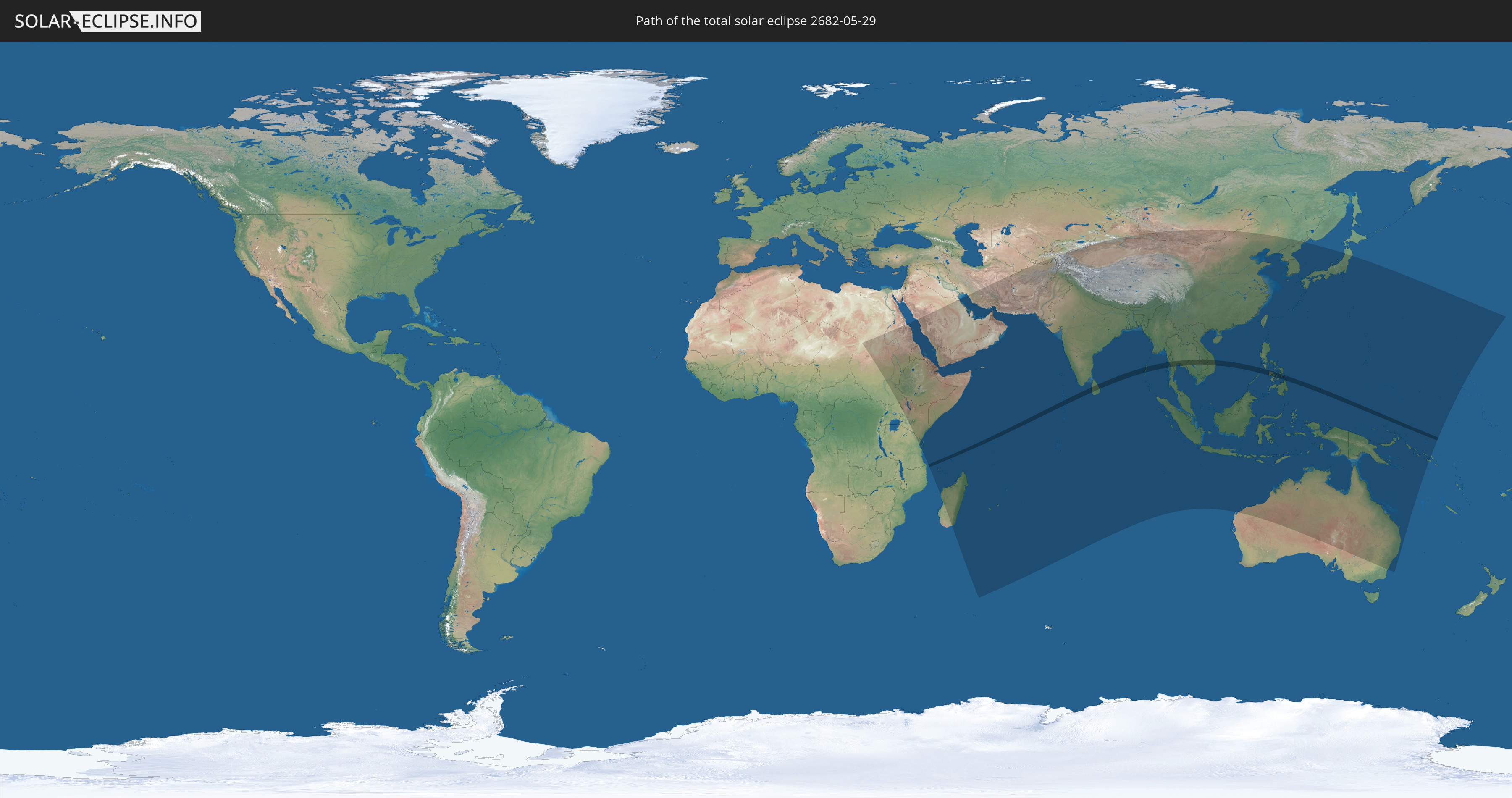
Die Sonnenfinsternis am 29.05.2682 kann man in 68 Ländern als partielle Sonnenfinsternis beobachten.
Der Finsternispfad verläuft durch 11 Länder. Nur in diesen Ländern ist sie als totale Sonnenfinsternis zu sehen.
In den folgenden Ländern ist die Sonnenfinsternis total zu sehen
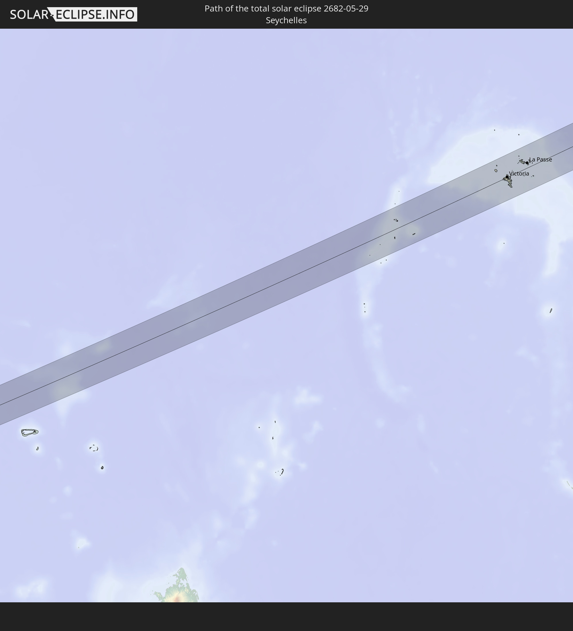 Seychellen
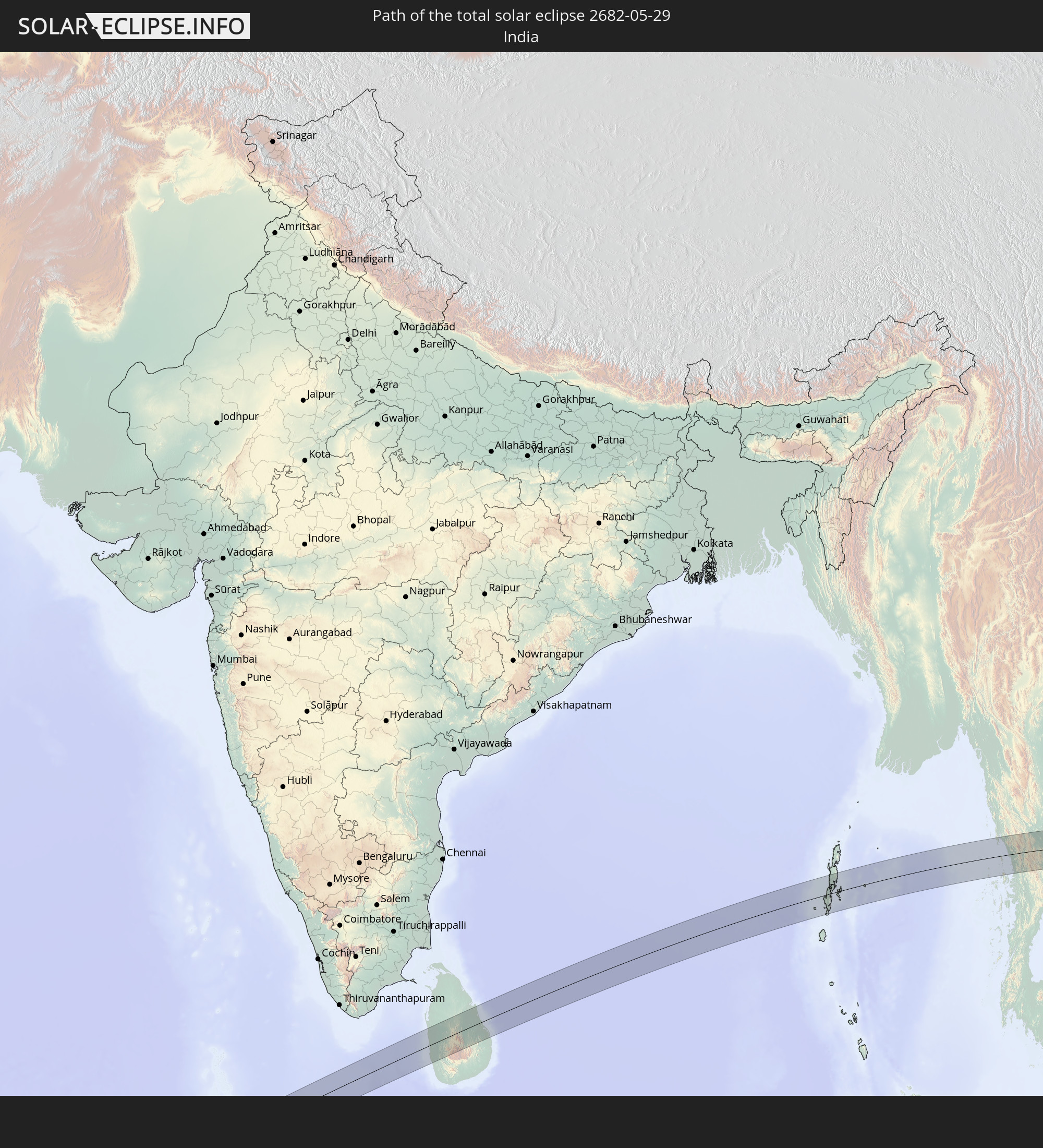 Indien
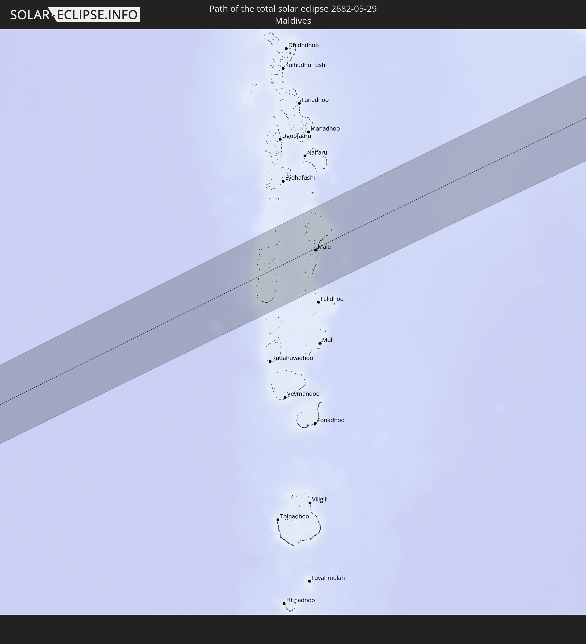 Malediven
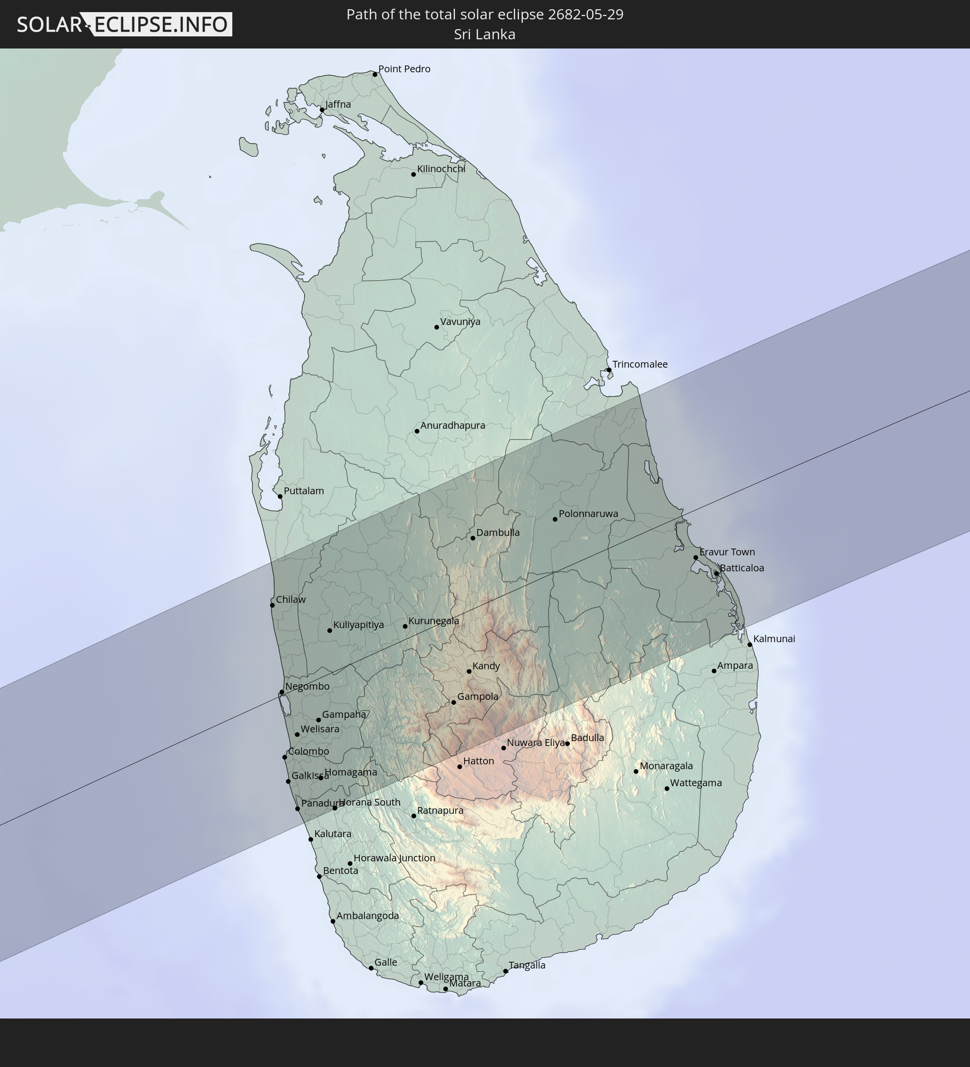 Sri Lanka
 Myanmar
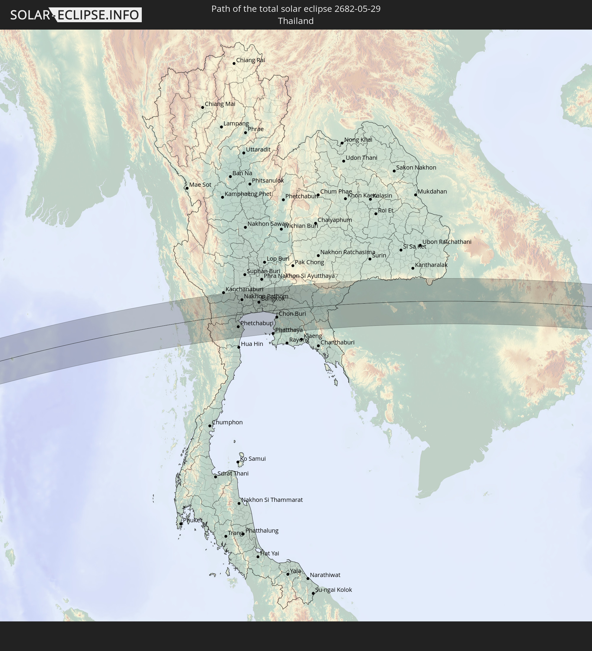 Thailand
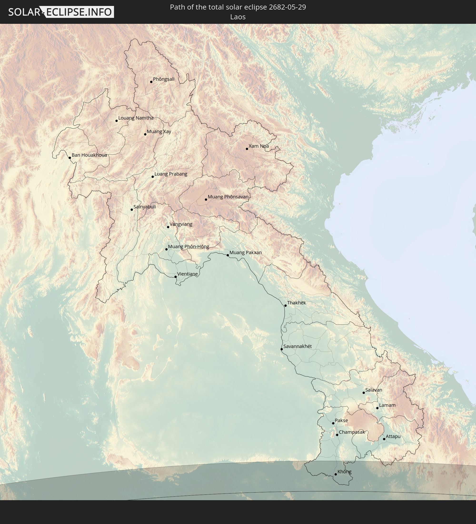 Laos
Laos
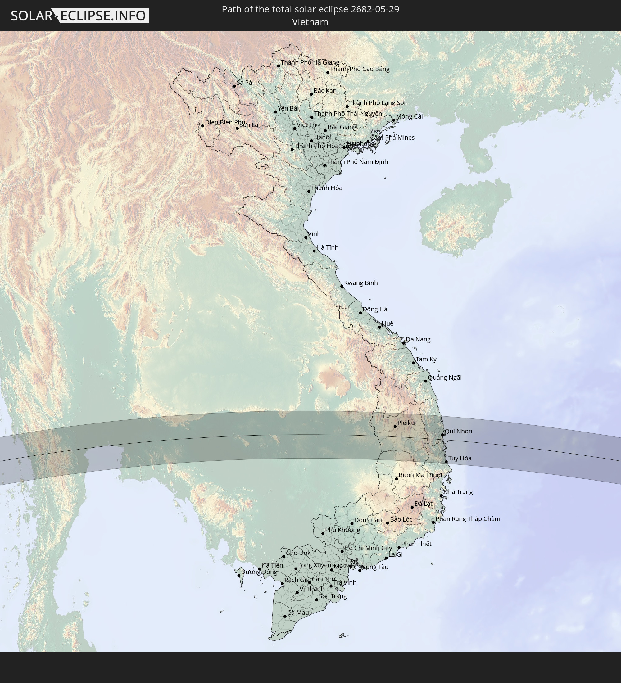 Vietnam
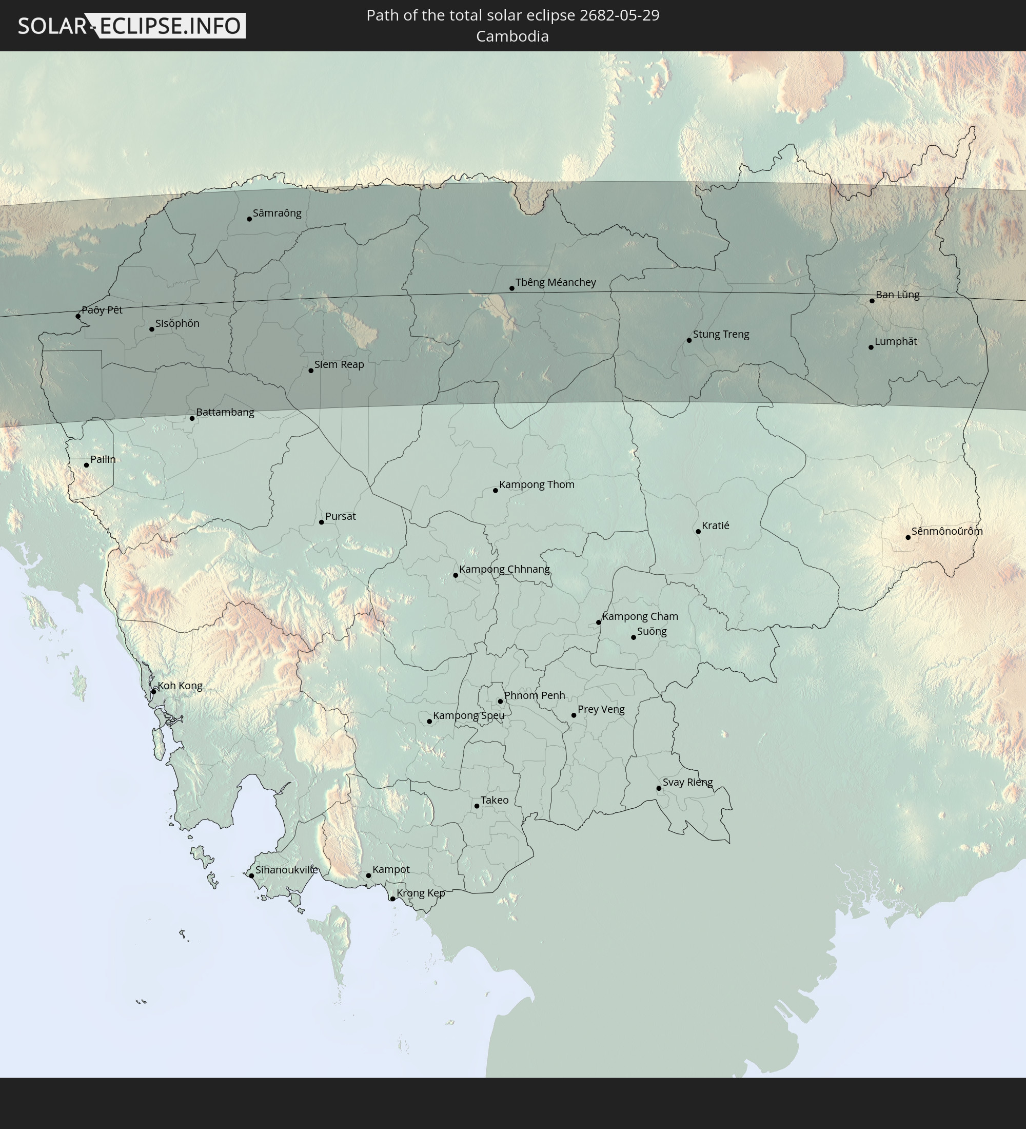 Kambodscha
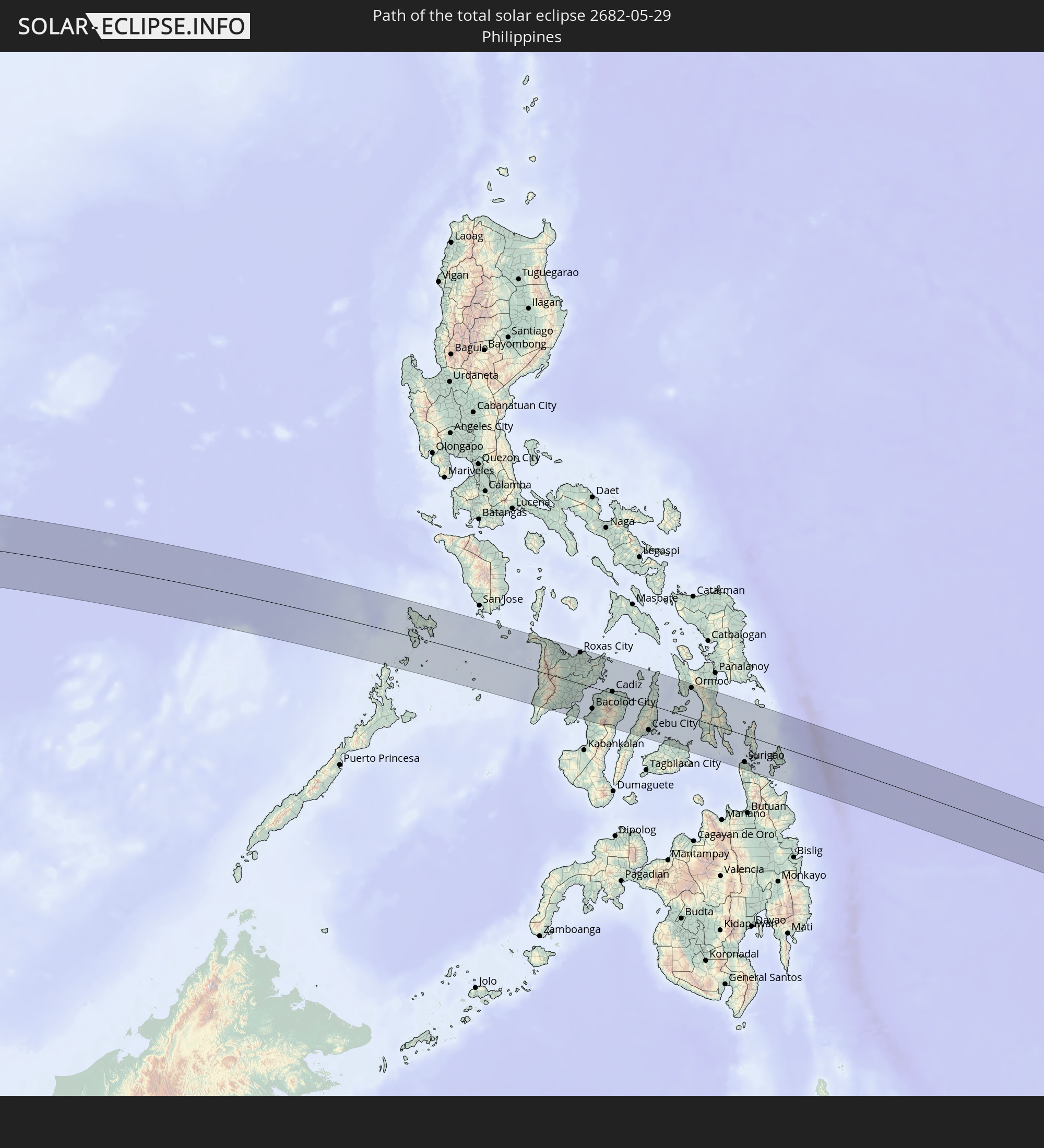 Philippinen
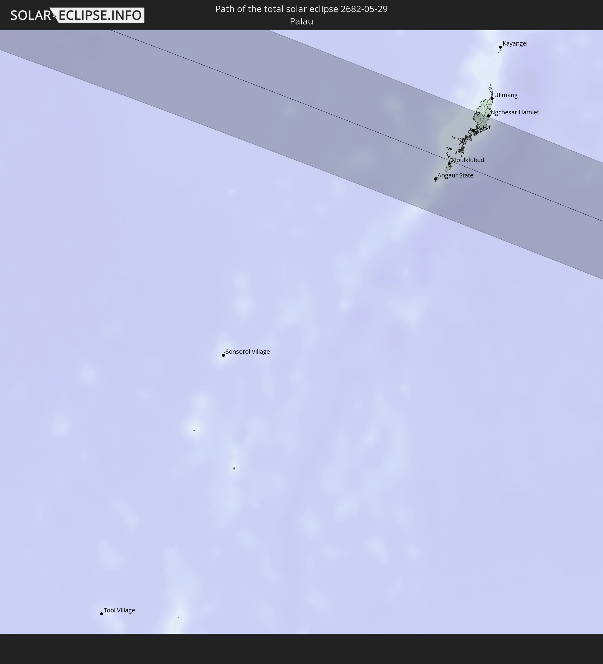 Palau
Palau
In den folgenden Ländern ist die Sonnenfinsternis partiell zu sehen
 Russland
 United States Minor Outlying Islands
 Sudan
Sudan
 Ägypten
 Tansania
 Uganda
 Äthiopien
 Kenia
Kenia
 Saudi-Arabien
 Eritrea
 Französische Süd- und Antarktisgebiete
 Somalia
 Dschibuti
 Jemen
Jemen
 Madagaskar
 Komoren
 Iran
Iran
 Mayotte
 Seychellen
 Kuwait
 Bahrain
 Katar
Katar
 Vereinigte Arabische Emirate
 Oman
Oman
 Turkmenistan
 Réunion
 Usbekistan
 Mauritius
 Afghanistan
 Pakistan
 Tadschikistan
 Indien
 Kirgisistan
 Britisches Territorium im Indischen Ozean
 Malediven
 Volksrepublik China
 Sri Lanka
 Nepal
Nepal
 Mongolei
 Bangladesch
 Bhutan
 Myanmar
 Indonesien
 Kokosinseln
 Thailand
 Malaysia
 Laos
Laos
 Vietnam
 Kambodscha
 Singapur
 Weihnachtsinsel
 Australien
 Macau
Macau
 Hongkong
 Brunei
 Taiwan
 Philippinen
 Japan
Japan
 Osttimor
 Nordkorea
 Südkorea
 Palau
Palau
 Föderierte Staaten von Mikronesien
 Papua-Neuguinea
 Guam
Guam
 Nördliche Marianen
 Salomonen
 Marshallinseln
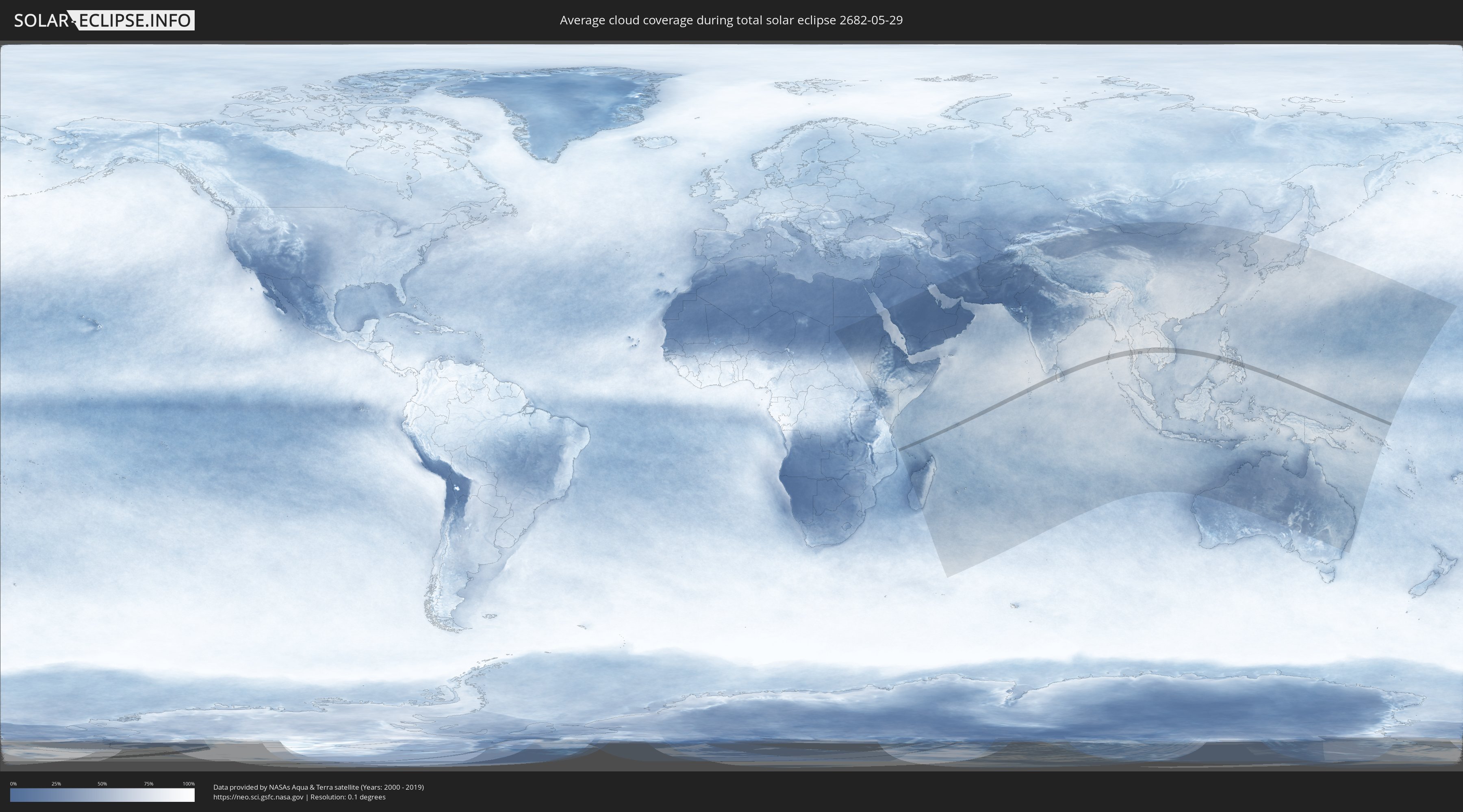
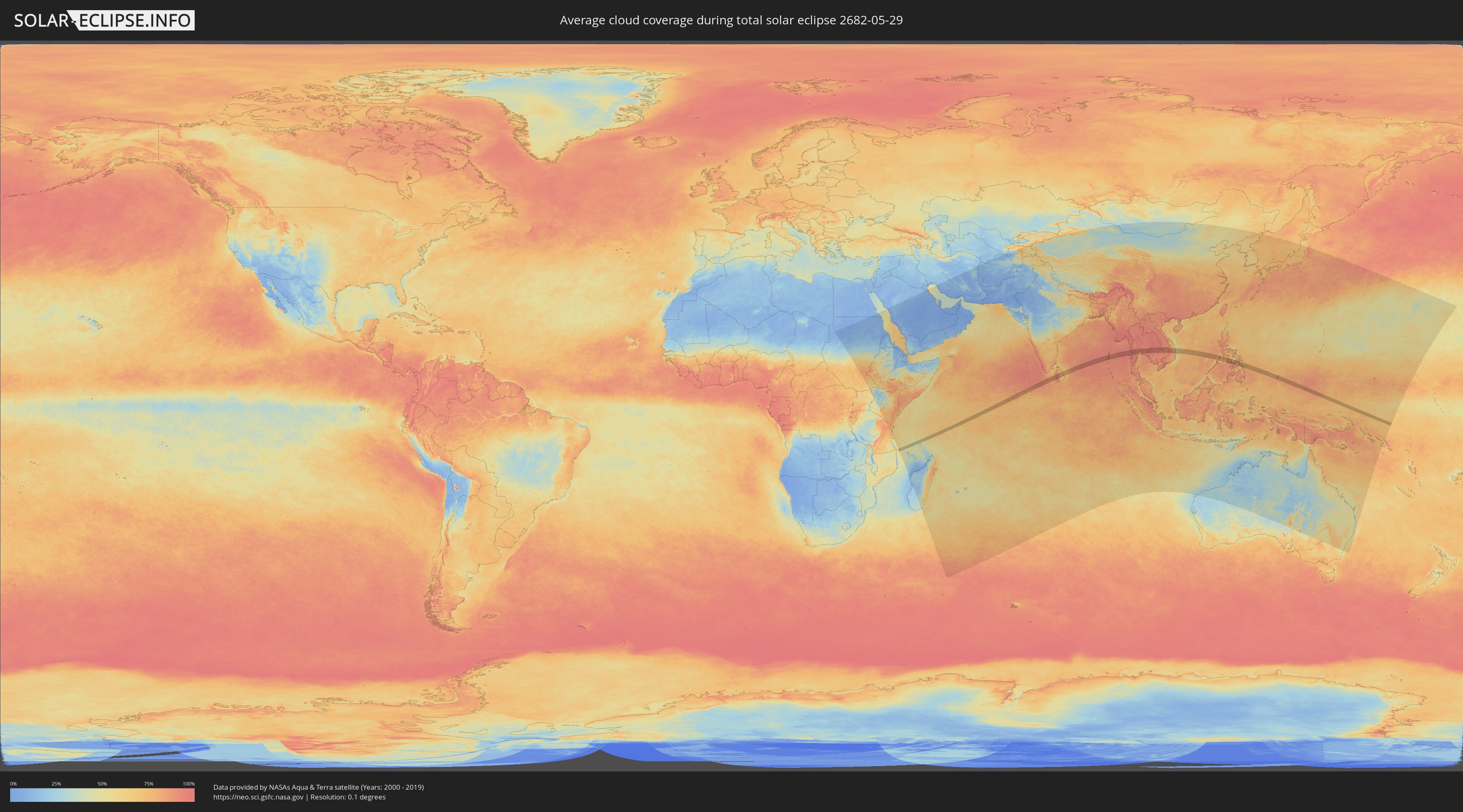
Wie wird das Wetter während der totalen Sonnenfinsternis am 29.05.2682?
Wo ist der beste Ort, um die totale Sonnenfinsternis vom 29.05.2682 zu beobachten?
Die folgenden Karten zeigen die durchschnittliche Bewölkung für den Tag, an dem die totale Sonnenfinsternis
stattfindet. Mit Hilfe der Karten lässt sich der Ort entlang des Finsternispfades eingrenzen,
der die besten Aussichen auf einen klaren wolkenfreien Himmel bietet.
Trotzdem muss man immer lokale Gegenenheiten beachten und sollte sich genau über das Wetter an seinem
gewählten Beobachtungsort informieren.
Die Daten stammen von den beiden NASA-Satelliten
AQUA und TERRA
und wurden über einen Zeitraum von 19 Jahren (2000 - 2019) gemittelt.
Detaillierte Länderkarten
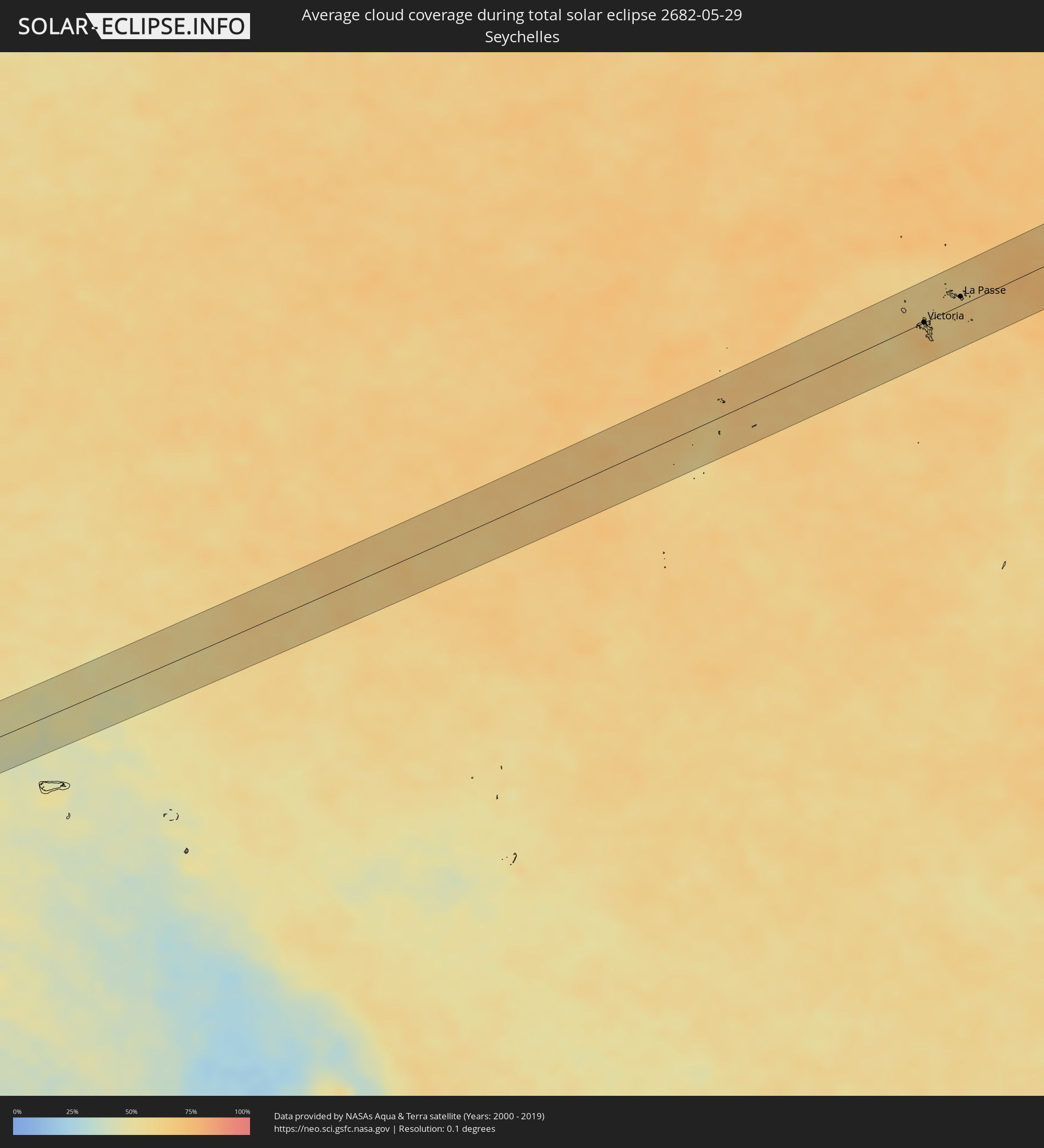 Seychellen
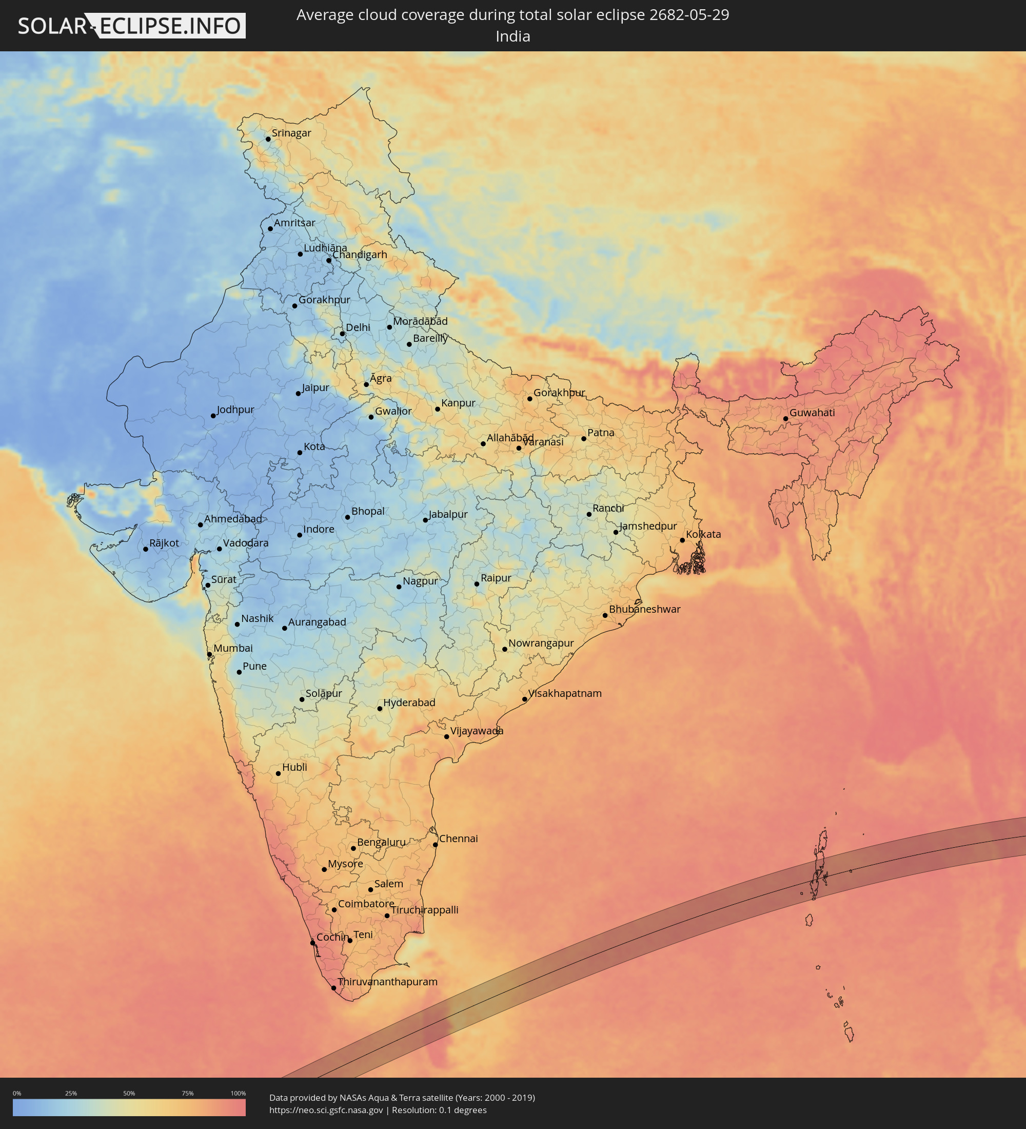 Indien
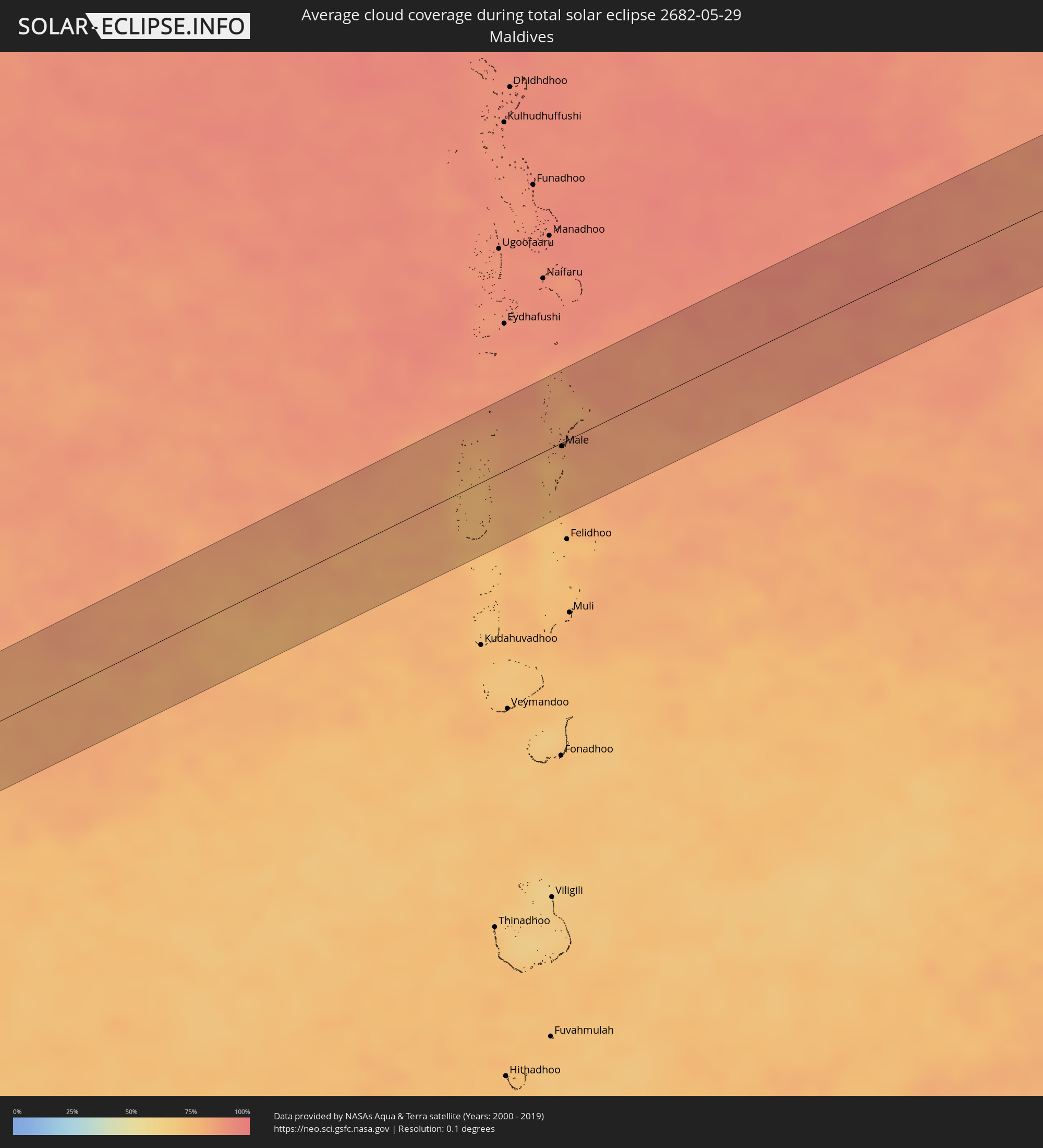 Malediven
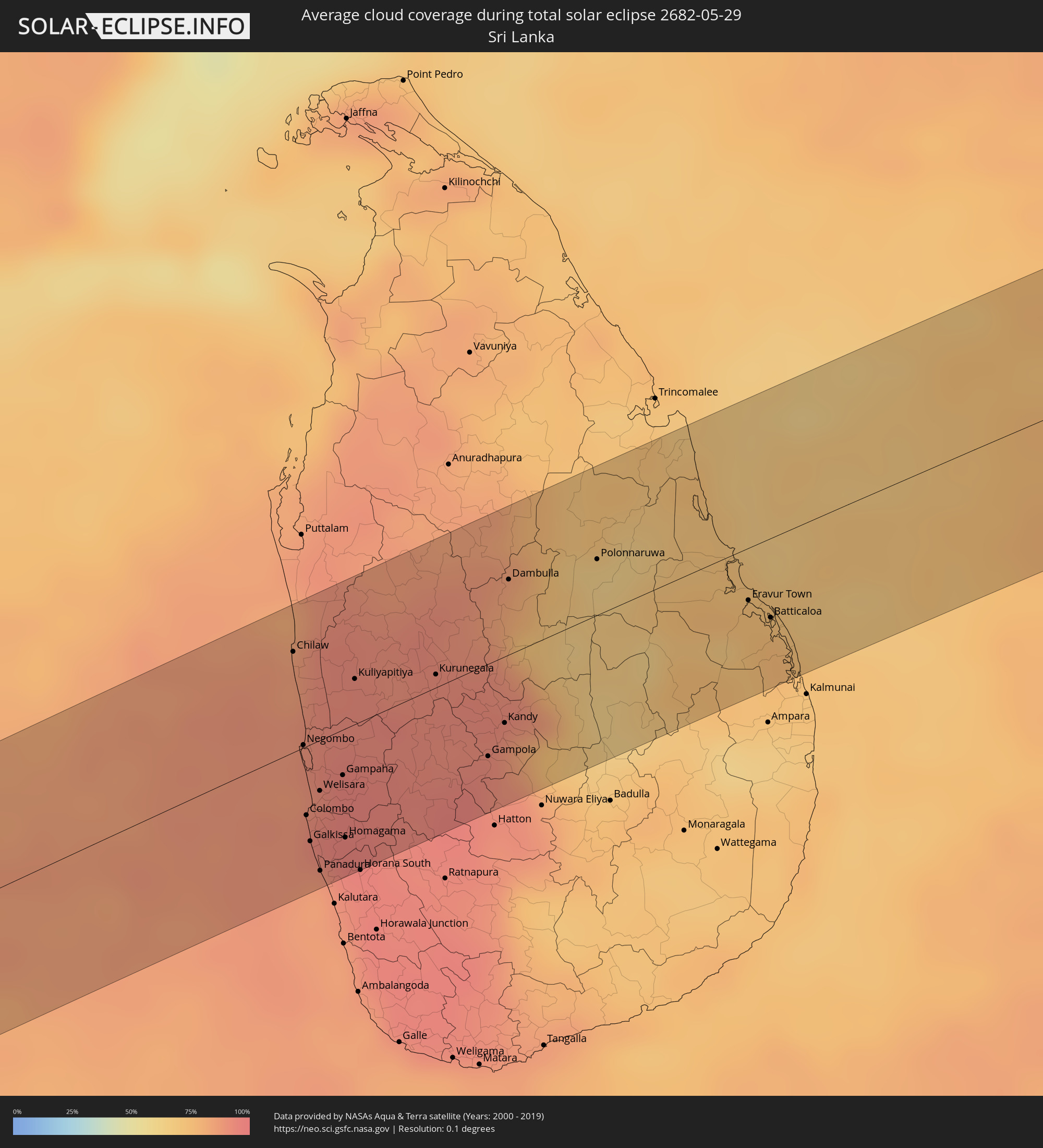 Sri Lanka
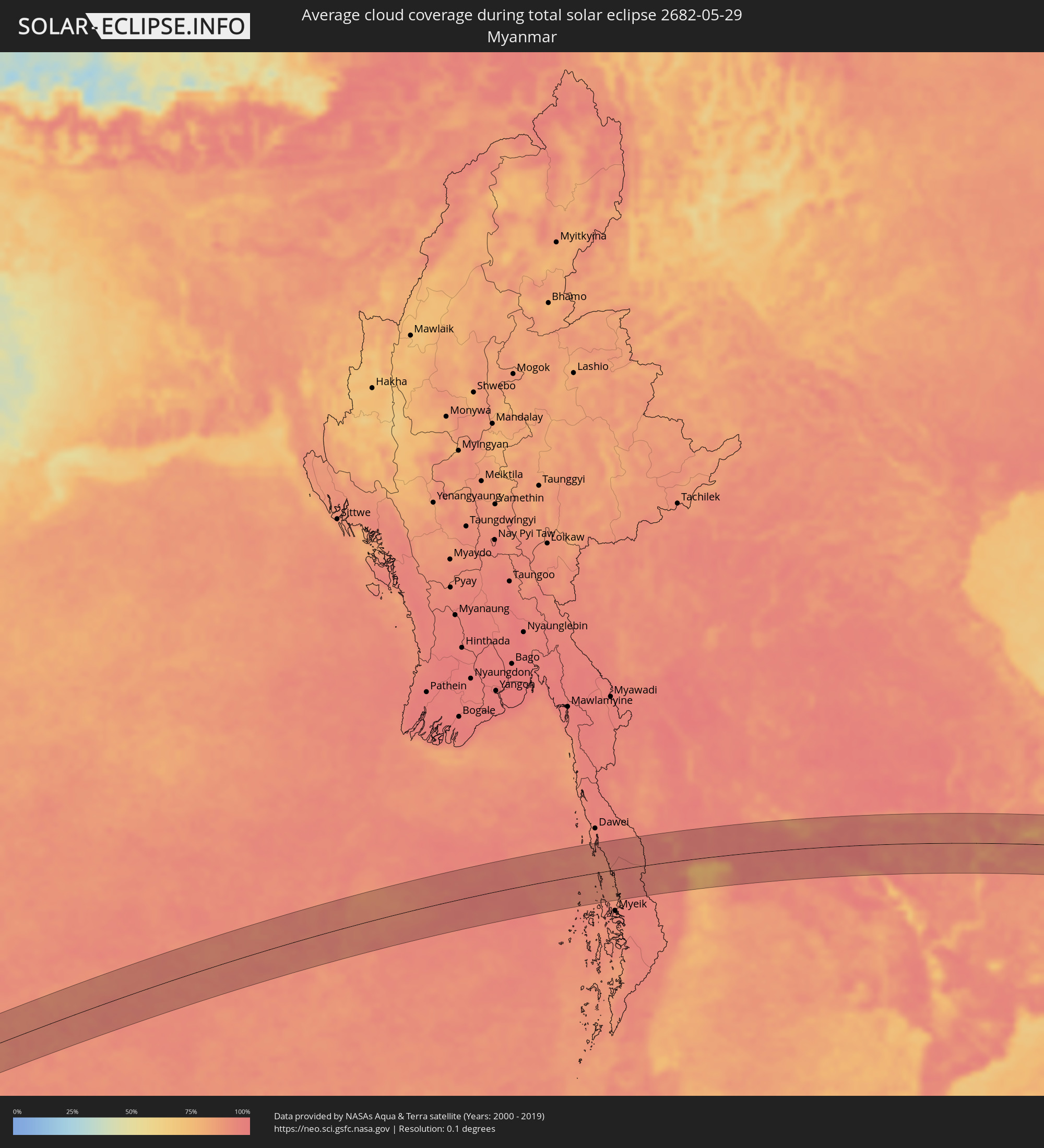 Myanmar
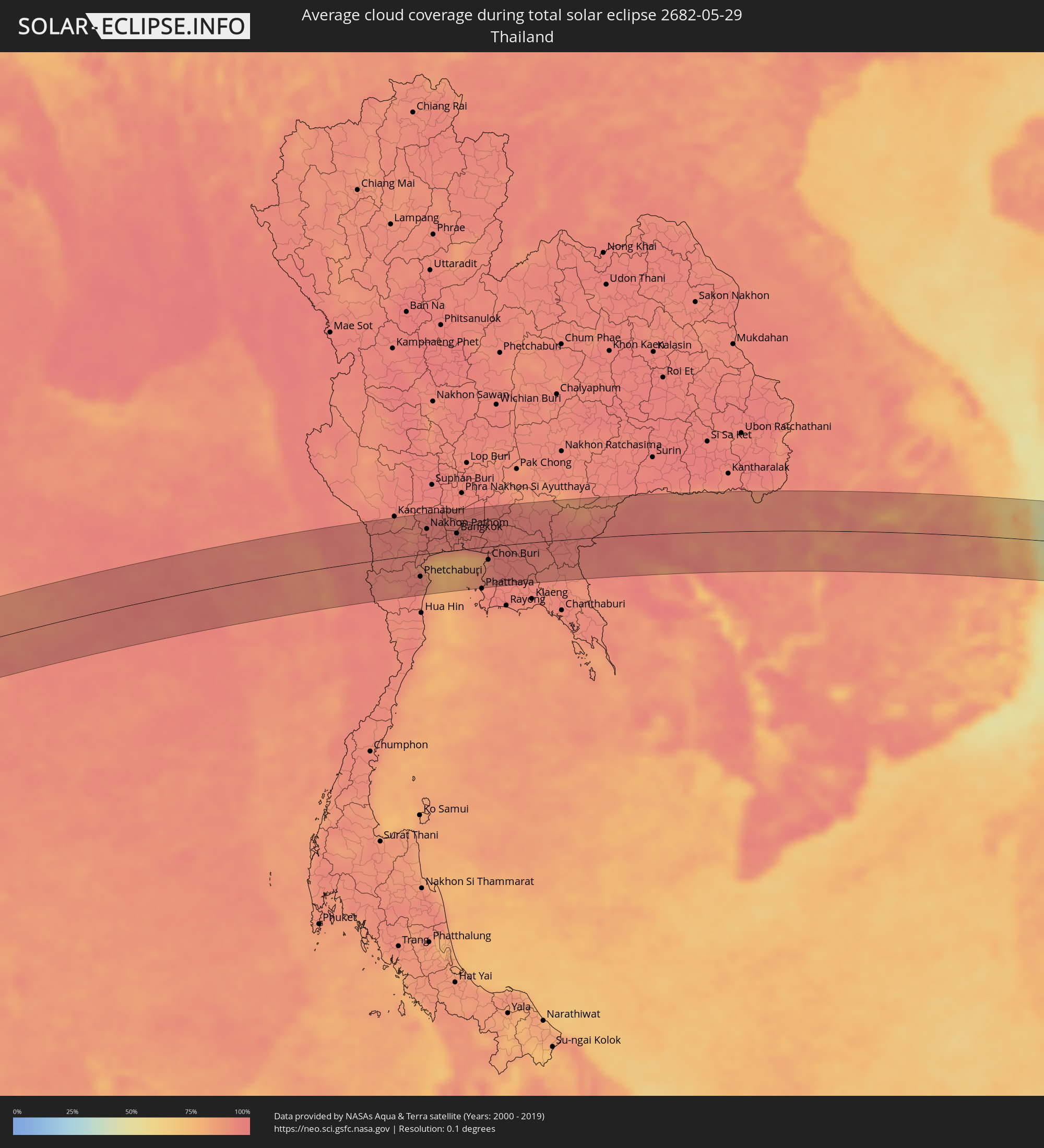 Thailand
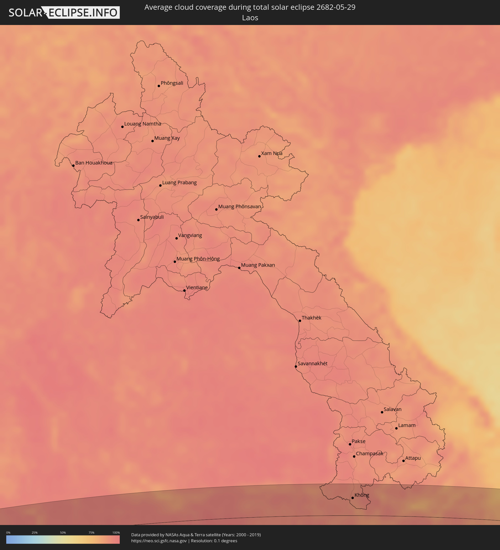 Laos
Laos
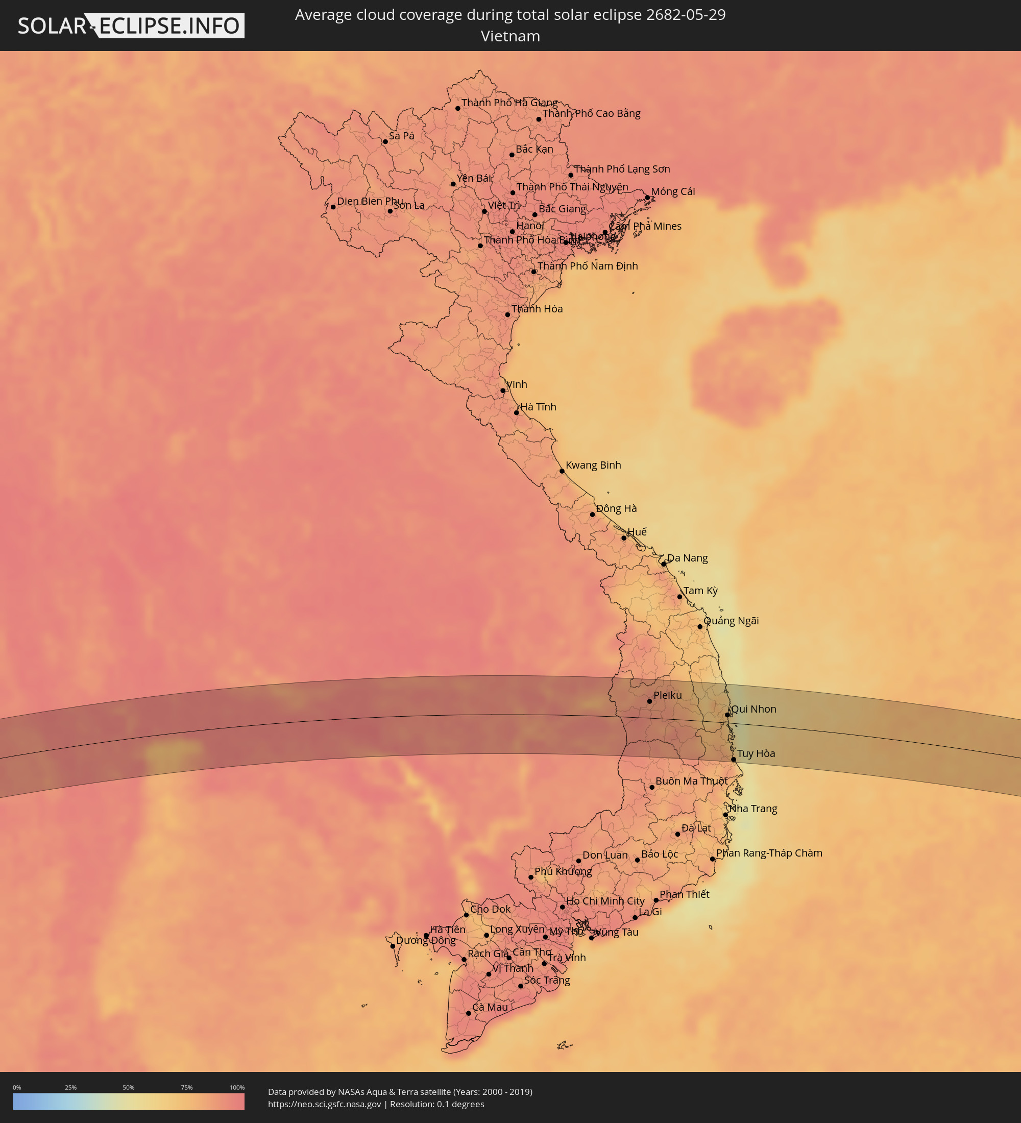 Vietnam
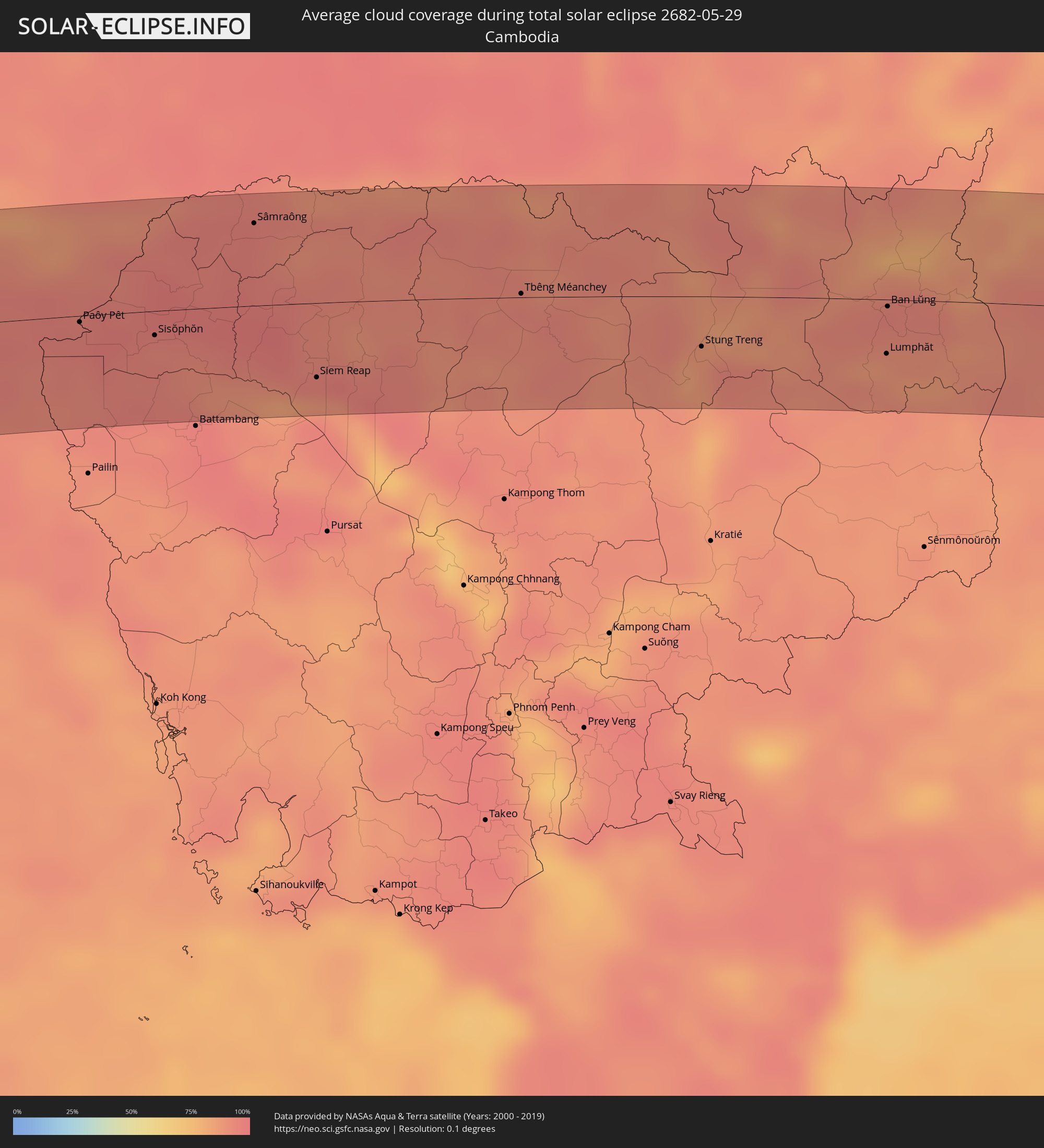 Kambodscha
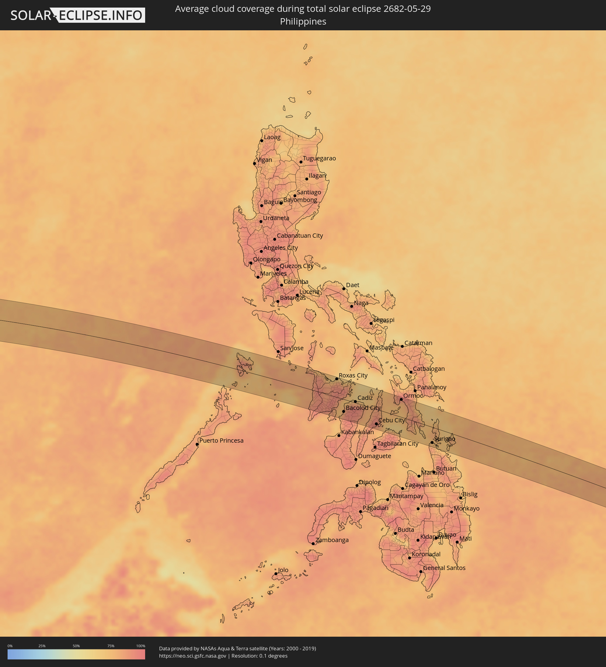 Philippinen
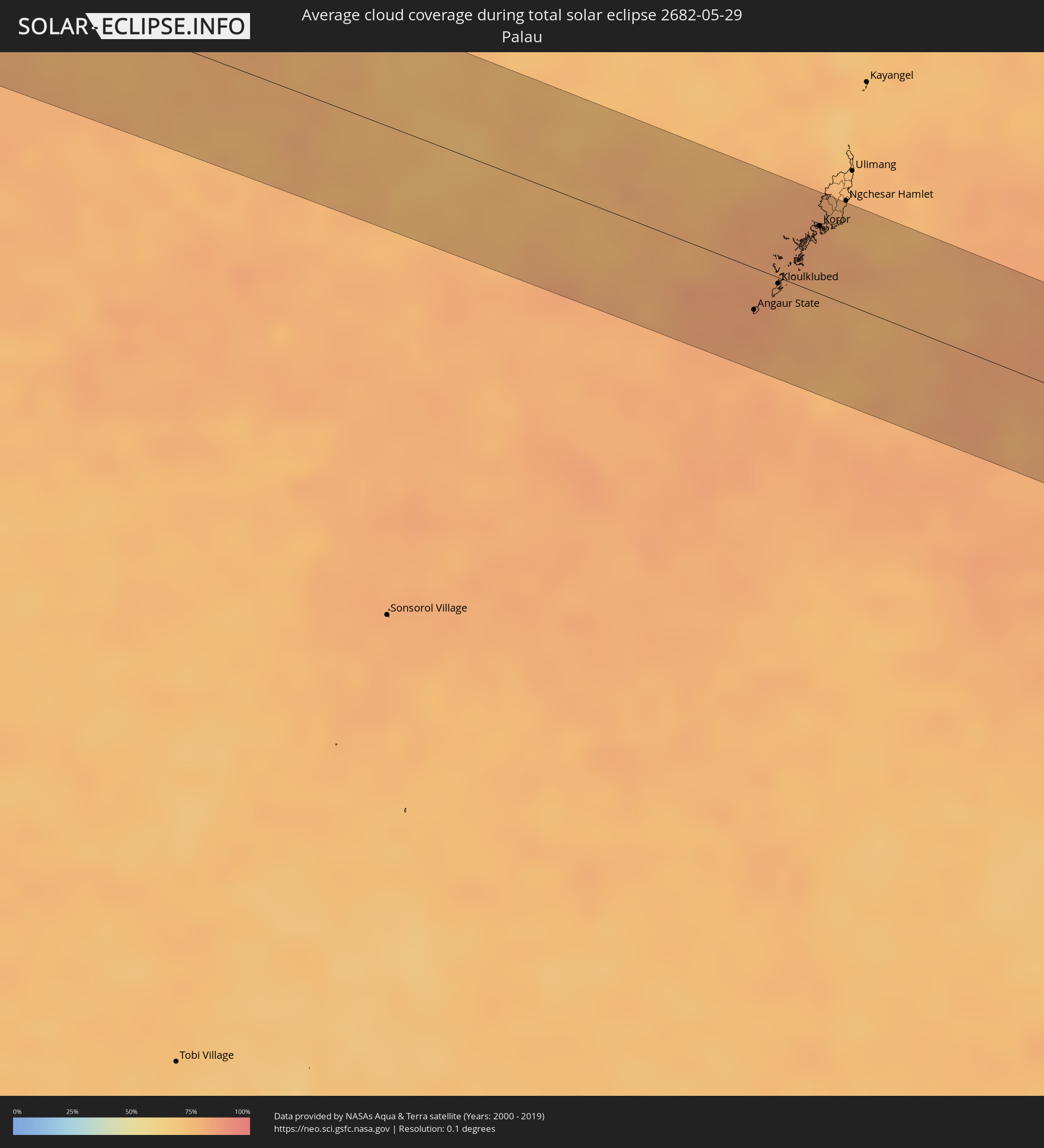 Palau
Palau
Orte im Finsternispfad
Die nachfolgene Tabelle zeigt Städte und Orte mit mehr als 5.000 Einwohnern, die sich im Finsternispfad befinden. Städte mit mehr als 100.000 Einwohnern sind dick gekennzeichnet. Mit einem Klick auf den Ort öffnet sich eine Detailkarte die die Lage des jeweiligen Ortes zusammen mit dem Verlauf der zentralen Finsternis präsentiert.
| Ort | Typ | Dauer der Verfinsterung | Ortszeit bei maximaler Verfinsterung | Entfernung zur Zentrallinie | Ø Bewölkung |
|
Port Glaud, Port Glaud
|
total | - | 07:35:54 UTC+04:00 | 4 km | 67% |
|
Bel Ombre, Bel Ombre
|
total | - | 07:35:55 UTC+04:00 | 2 km | 73% |
|
Beau Vallon, Beau Vallon
|
total | - | 07:35:56 UTC+04:00 | 1 km | 73% |
|
Victoria, English River
|
total | - | 07:35:56 UTC+04:00 | 0 km | 69% |
|
Anse Boileau, Anse Boileau
|
total | - | 07:35:55 UTC+04:00 | 12 km | 69% |
|
Takamaka, Takamaka
|
total | - | 07:35:55 UTC+04:00 | 17 km | 65% |
|
Cascade, Cascade
|
total | - | 07:35:57 UTC+04:00 | 7 km | 69% |
|
Anse Royale, Anse Royale
|
total | - | 07:35:56 UTC+04:00 | 15 km | 69% |
|
La Passe, Inner Islands
|
total | - | 07:36:14 UTC+04:00 | 9 km | 67% |
|
Male, Kaafu Atoll
|
total | - | 08:58:57 UTC+05:00 | 3 km | 82% |
|
Chilaw, North Western
|
total | - | 09:43:13 UTC+05:30 | 40 km | 86% |
|
Negombo, Western
|
total | - | 09:42:58 UTC+05:30 | 1 km | 88% |
|
Colombo, Western
|
total | - | 09:42:45 UTC+05:30 | 28 km | 89% |
|
Moratuwa, Western
|
total | - | 09:42:41 UTC+05:30 | 45 km | 88% |
|
Hendala, Western
|
total | - | 09:42:52 UTC+05:30 | 23 km | 93% |
|
Peliyagoda, Western
|
total | - | 09:42:51 UTC+05:30 | 25 km | 93% |
|
Wattala, Western
|
total | - | 09:42:52 UTC+05:30 | 25 km | 93% |
|
Ja Ela, Western
|
total | - | 09:42:58 UTC+05:30 | 15 km | 91% |
|
Kandana, Western
|
total | - | 09:42:57 UTC+05:30 | 18 km | 93% |
|
Welisara, Western
|
total | - | 09:42:56 UTC+05:30 | 20 km | 93% |
|
Panadura, Western
|
total | - | 09:42:40 UTC+05:30 | 52 km | 85% |
|
Kelaniya, Western
|
total | - | 09:42:55 UTC+05:30 | 29 km | 93% |
|
Mulleriyawa, Western
|
total | - | 09:42:55 UTC+05:30 | 31 km | 93% |
|
Homagama, Western
|
total | - | 09:42:59 UTC+05:30 | 44 km | 95% |
|
Kurunegala, North Western
|
total | - | 09:44:19 UTC+05:30 | 5 km | 92% |
|
Gampola, Central
|
total | - | 09:44:28 UTC+05:30 | 37 km | 91% |
|
Kandy, Central
|
total | - | 09:44:43 UTC+05:30 | 27 km | 91% |
|
Dambulla, Central
|
total | - | 09:45:15 UTC+05:30 | 30 km | 79% |
|
Eravur Town, Eastern Province
|
total | - | 09:47:14 UTC+05:30 | 21 km | 73% |
|
Batticaloa, Eastern Province
|
total | - | 09:47:23 UTC+05:30 | 32 km | 75% |
|
Bamboo Flat, Andaman and Nicobar Islands
|
total | - | 10:19:51 UTC+05:30 | 33 km | 92% |
|
Port Blair, Andaman and Nicobar Islands
|
total | - | 10:19:56 UTC+05:30 | 37 km | 93% |
|
Tha Maka, Kanchanaburi
|
total | - | 12:13:25 UTC+07:00 | 53 km | 90% |
|
Ratchaburi, Ratchaburi
|
total | - | 12:13:26 UTC+07:00 | 12 km | 94% |
|
Ban Pong, Ratchaburi
|
total | - | 12:13:44 UTC+07:00 | 42 km | 91% |
|
Tha Yang, Phetchaburi
|
total | - | 12:13:29 UTC+07:00 | 53 km | 94% |
|
Phetchaburi, Phetchaburi
|
total | - | 12:13:41 UTC+07:00 | 36 km | 95% |
|
Samut Songkhram, Samut Songkhram
|
total | - | 12:13:59 UTC+07:00 | 4 km | 87% |
|
Nakhon Pathom, Nakhon Pathom
|
total | - | 12:14:17 UTC+07:00 | 40 km | 95% |
|
Ban Phaeo, Samut Sakhon
|
total | - | 12:14:24 UTC+07:00 | 14 km | 94% |
|
Krathum Baen, Samut Sakhon
|
total | - | 12:14:55 UTC+07:00 | 19 km | 94% |
|
Pak Kret, Nonthaburi
|
total | - | 12:15:48 UTC+07:00 | 45 km | 94% |
|
Bangkok, Bangkok
|
total | - | 12:15:45 UTC+07:00 | 27 km | 95% |
|
Samut Prakan, Samut Prakan
|
total | - | 12:16:00 UTC+07:00 | 9 km | 89% |
|
Khlong Luang, Pathum Thani
|
total | - | 12:16:20 UTC+07:00 | 60 km | 94% |
|
Ban Lam Luk Ka, Pathum Thani
|
total | - | 12:16:44 UTC+07:00 | 49 km | 95% |
|
Ban Khlong Bang Sao Thong, Samut Prakan
|
total | - | 12:16:47 UTC+07:00 | 11 km | 94% |
|
Si Racha, Chon Buri
|
total | - | 12:16:57 UTC+07:00 | 42 km | 89% |
|
Chon Buri, Chon Buri
|
total | - | 12:17:11 UTC+07:00 | 22 km | 91% |
|
Chachoengsao, Chachoengsao
|
total | - | 12:17:35 UTC+07:00 | 14 km | 95% |
|
Prachin Buri, Prachin Buri
|
total | - | 12:18:40 UTC+07:00 | 50 km | 93% |
|
Sa Kaeo, Sa Kaeo
|
total | - | 12:20:54 UTC+07:00 | 18 km | 96% |
|
Paôy Pêt, Banteay Meanchey
|
total | - | 12:22:28 UTC+07:00 | 4 km | 95% |
|
Sisŏphŏn, Banteay Meanchey
|
total | - | 12:23:47 UTC+07:00 | 14 km | 93% |
|
Sâmraông, Ŏtâr Méanchey
|
total | - | 12:25:41 UTC+07:00 | 49 km | 96% |
|
Siem Reap, Siem Reap
|
total | - | 12:26:40 UTC+07:00 | 44 km | 94% |
|
Tbêng Méanchey, Preah Vihear
|
total | - | 12:30:23 UTC+07:00 | 2 km | 94% |
|
Không, Champasak
|
total | - | 12:33:13 UTC+07:00 | 36 km | 89% |
|
Stung Treng, Stung Treng
|
total | - | 12:33:34 UTC+07:00 | 30 km | 89% |
|
Lumphăt, Ratanakiri
|
total | - | 12:36:50 UTC+07:00 | 32 km | 88% |
|
Ban Lŭng, Ratanakiri
|
total | - | 12:36:51 UTC+07:00 | 4 km | 93% |
|
Pleiku, Gia Lai
|
total | - | 12:40:03 UTC+07:00 | 27 km | 88% |
|
Sông Cầu, Phú Yên
|
total | - | 12:43:55 UTC+07:00 | 23 km | 73% |
|
Qui Nhon, Bình Định
|
total | - | 12:43:53 UTC+07:00 | 12 km | 68% |
|
Tuy Hòa, Phú Yên
|
total | - | 12:44:16 UTC+07:00 | 62 km | 82% |
|
Pandan, Western Visayas
|
total | - | 14:19:22 UTC+08:00 | 51 km | 87% |
|
Kalibo (poblacion), Western Visayas
|
total | - | 14:19:58 UTC+08:00 | 55 km | 76% |
|
Iloilo, Western Visayas
|
total | - | 14:20:57 UTC+08:00 | 46 km | 84% |
|
Passi, Western Visayas
|
total | - | 14:20:54 UTC+08:00 | 0 km | 93% |
|
Roxas City, Western Visayas
|
total | - | 14:20:53 UTC+08:00 | 54 km | 83% |
|
Bago City, Western Visayas
|
total | - | 14:21:38 UTC+08:00 | 55 km | 76% |
|
Bacolod City, Western Visayas
|
total | - | 14:21:49 UTC+08:00 | 37 km | 91% |
|
Maao, Western Visayas
|
total | - | 14:22:00 UTC+08:00 | 55 km | 92% |
|
Victorias, Western Visayas
|
total | - | 14:21:57 UTC+08:00 | 9 km | 90% |
|
Canlaon, Central Visayas
|
total | - | 14:22:33 UTC+08:00 | 59 km | 88% |
|
Cadiz, Western Visayas
|
total | - | 14:22:23 UTC+08:00 | 3 km | 91% |
|
Ualog, Western Visayas
|
total | - | 14:22:49 UTC+08:00 | 33 km | 84% |
|
Escalante, Western Visayas
|
total | - | 14:22:54 UTC+08:00 | 2 km | 83% |
|
Toledo, Central Visayas
|
total | - | 14:23:26 UTC+08:00 | 46 km | 82% |
|
Balamban, Central Visayas
|
total | - | 14:23:32 UTC+08:00 | 30 km | 87% |
|
Cebu City, Central Visayas
|
total | - | 14:24:00 UTC+08:00 | 45 km | 82% |
|
Bogo, Central Visayas
|
total | - | 14:23:50 UTC+08:00 | 37 km | 81% |
|
Danao, Central Visayas
|
total | - | 14:24:11 UTC+08:00 | 18 km | 81% |
|
Ormoc, Eastern Visayas
|
total | - | 14:25:06 UTC+08:00 | 52 km | 78% |
|
Surigao, Caraga
|
total | - | 14:27:33 UTC+08:00 | 47 km | 76% |
|
Angaur State, Angaur
|
total | - | 15:43:16 UTC+09:00 | 22 km | 83% |
|
Kloulklubed, Peleliu
|
total | - | 15:43:22 UTC+09:00 | 3 km | 80% |
|
Koror, Koror
|
total | - | 15:43:30 UTC+09:00 | 36 km | 80% |
|
Ngchemiangel, Aimeliik
|
total | - | 15:43:27 UTC+09:00 | 48 km | 82% |
|
Koror Town, Koror
|
total | - | 15:43:30 UTC+09:00 | 37 km | 80% |
|
Ngereklmadel, Ngatpang
|
total | - | 15:43:26 UTC+09:00 | 52 km | 82% |
|
Ngetkib, Airai
|
total | - | 15:43:32 UTC+09:00 | 41 km | 82% |