Totale Sonnenfinsternis vom 03.12.2719
| Wochentag: | Mittwoch |
| Maximale Dauer der Verfinsterung: | 03m01s |
| Maximale Breite des Finsternispfades: | 180 km |
| Saroszyklus: | 173 |
| Bedeckungsgrad: | 100% |
| Magnitude: | 1.0331 |
| Gamma: | 0.7837 |
Wo kann man die Sonnenfinsternis vom 03.12.2719 sehen?
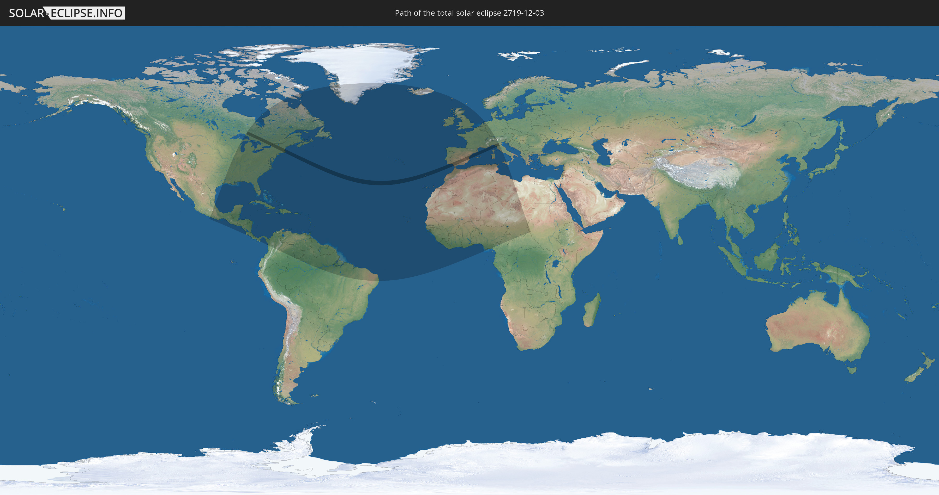
Die Sonnenfinsternis am 03.12.2719 kann man in 92 Ländern als partielle Sonnenfinsternis beobachten.
Der Finsternispfad verläuft durch 6 Länder. Nur in diesen Ländern ist sie als totale Sonnenfinsternis zu sehen.
In den folgenden Ländern ist die Sonnenfinsternis total zu sehen
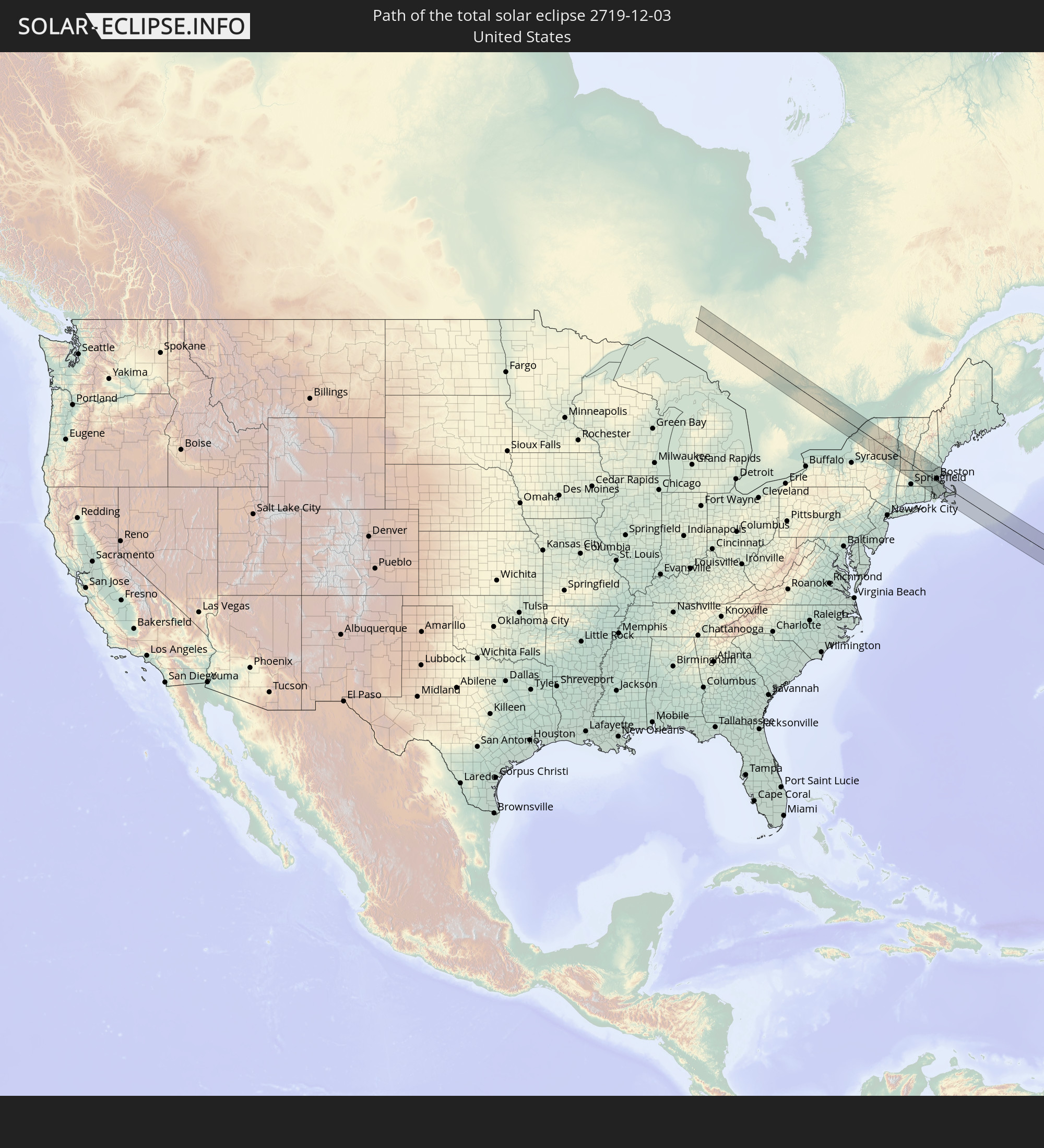 Vereinigte Staaten
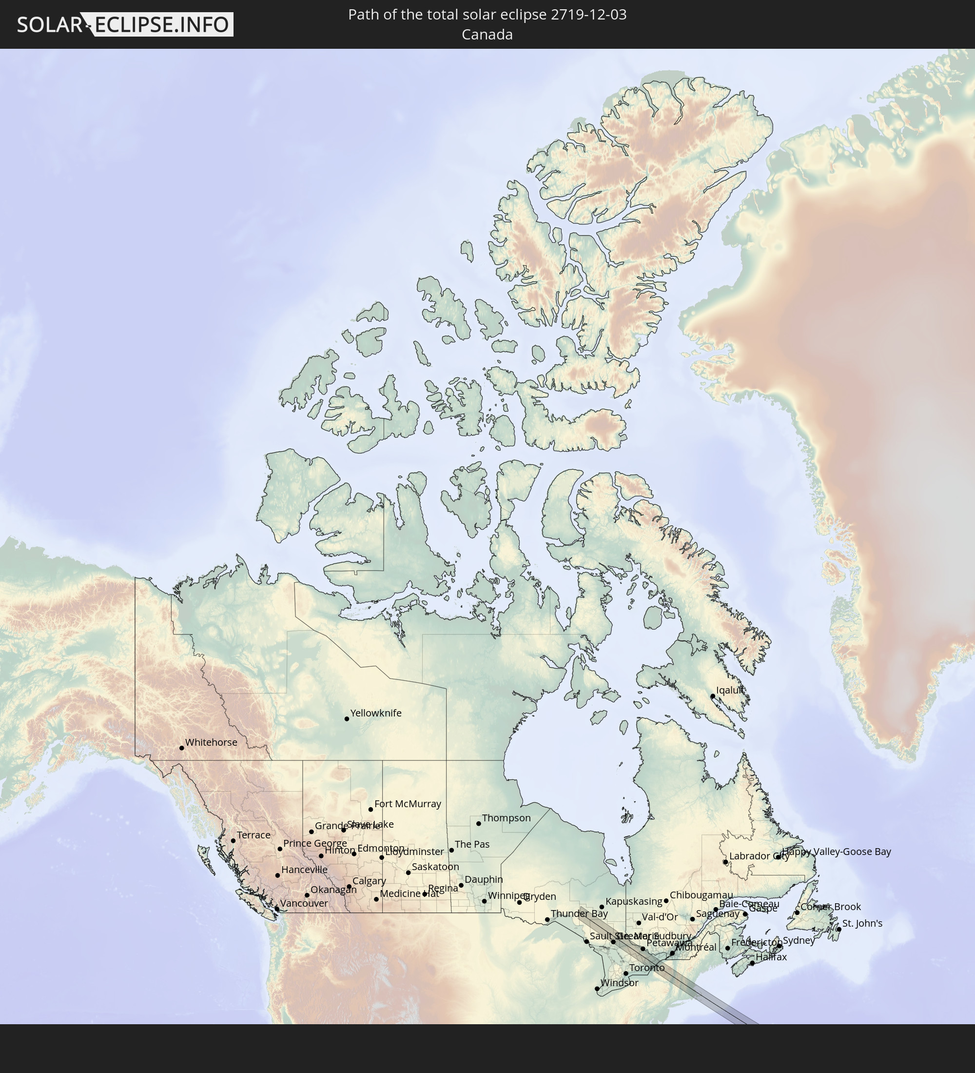 Kanada
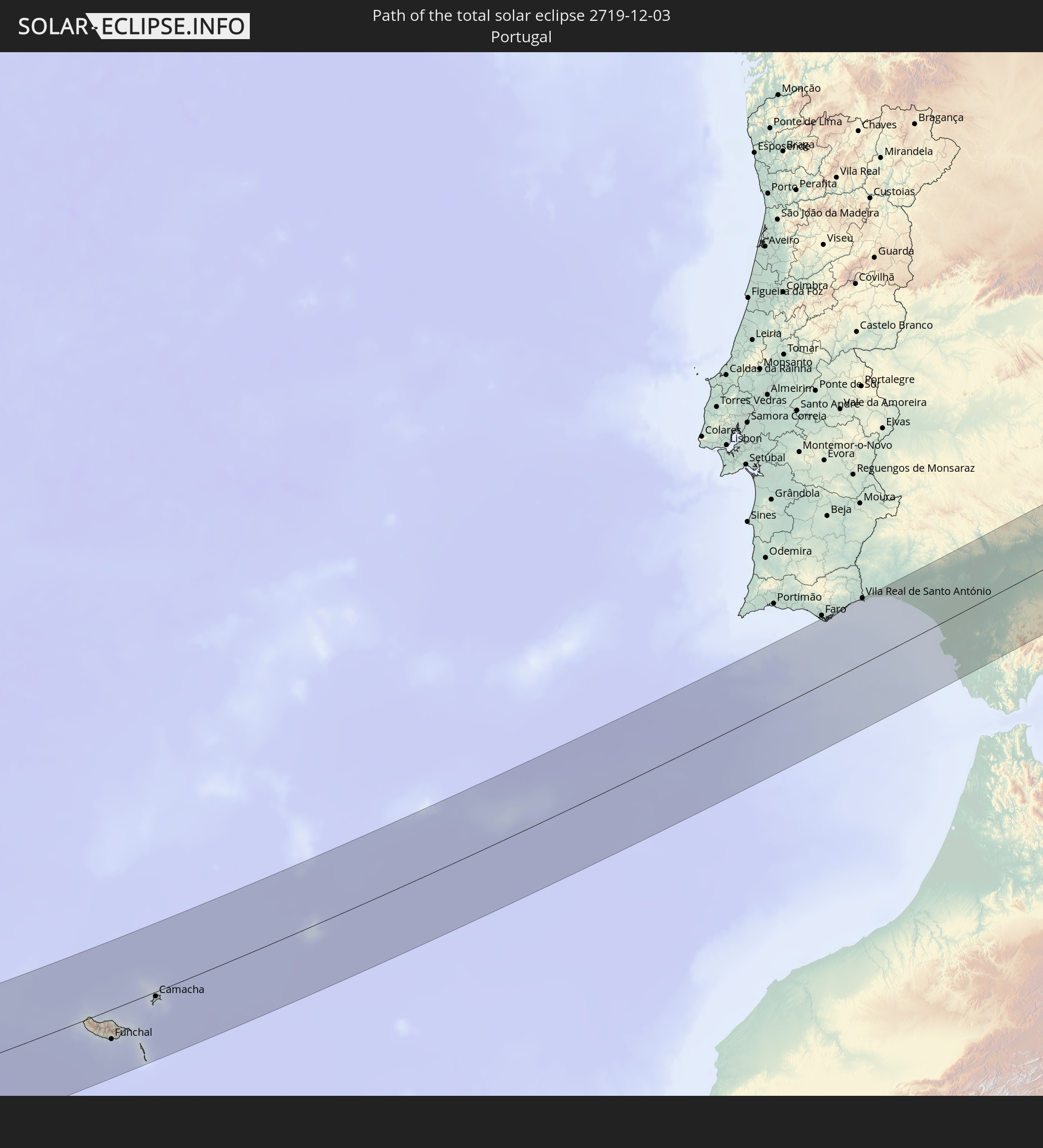 Portugal
 Spanien
 Frankreich
 Italien
In den folgenden Ländern ist die Sonnenfinsternis partiell zu sehen
 Vereinigte Staaten
 United States Minor Outlying Islands
 Kanada
 Mexiko
 Grönland
 Guatemala
 El Salvador
 Honduras
 Belize
 Nicaragua
 Costa Rica
 Kuba
Kuba
 Panama
 Kolumbien
 Kaimaninseln
 Bahamas
 Jamaika
 Haiti
Haiti
 Brasilien
 Venezuela
 Turks- und Caicosinseln
 Dominikanische Republik
 Aruba
Aruba
 Puerto Rico
 Amerikanische Jungferninseln
 Bermuda
 Britische Jungferninseln
 Anguilla
 Saint-Martin
 Saint-Barthélemy
 St. Kitts und Nevis
 Antigua und Barbuda
 Montserrat
 Trinidad und Tobago
 Guadeloupe
 Grenada
 Dominica
 St. Vincent und die Grenadinen
 Guyana
 Martinique
 St. Lucia
 Barbados
 Suriname
 Saint-Pierre und Miquelon
 Französisch-Guayana
 Portugal
 Kap Verde
 Island
 Spanien
 Senegal
 Mauretanien
 Gambia
 Guinea-Bissau
 Guinea
 Sierra Leone
 Marokko
 Mali
Mali
 Liberia
 Irland
 Algerien
 Vereinigtes Königreich
 Elfenbeinküste
 Färöer
 Burkina Faso
 Gibraltar
 Frankreich
 Isle of Man
 Ghana
Ghana
 Guernsey
 Jersey
 Togo
Togo
 Niger
Niger
 Benin
Benin
 Andorra
 Belgien
 Nigeria
 Niederlande
 Luxemburg
 Deutschland
 Schweiz
 Italien
 Monaco
 Tunesien
 Kamerun
 Libyen
 Liechtenstein
 Österreich
 Vatikanstadt
 Tschad
 Malta
Malta
 Zentralafrikanische Republik
 Sudan
Sudan
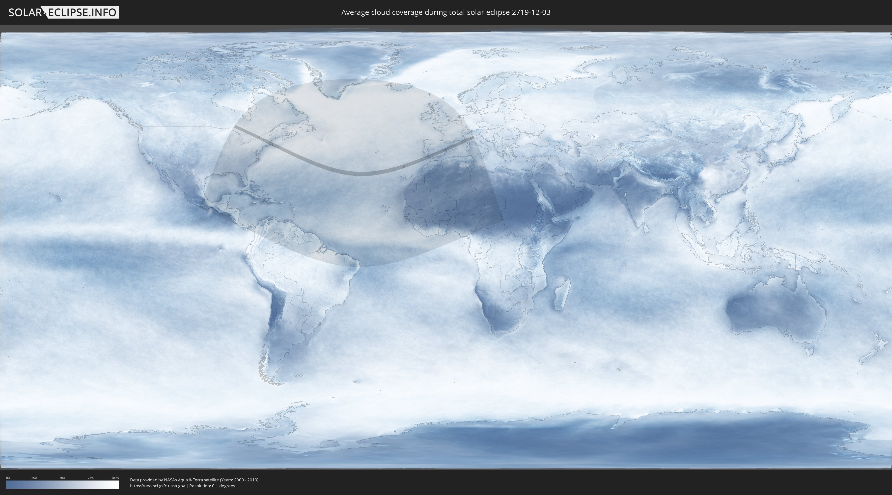
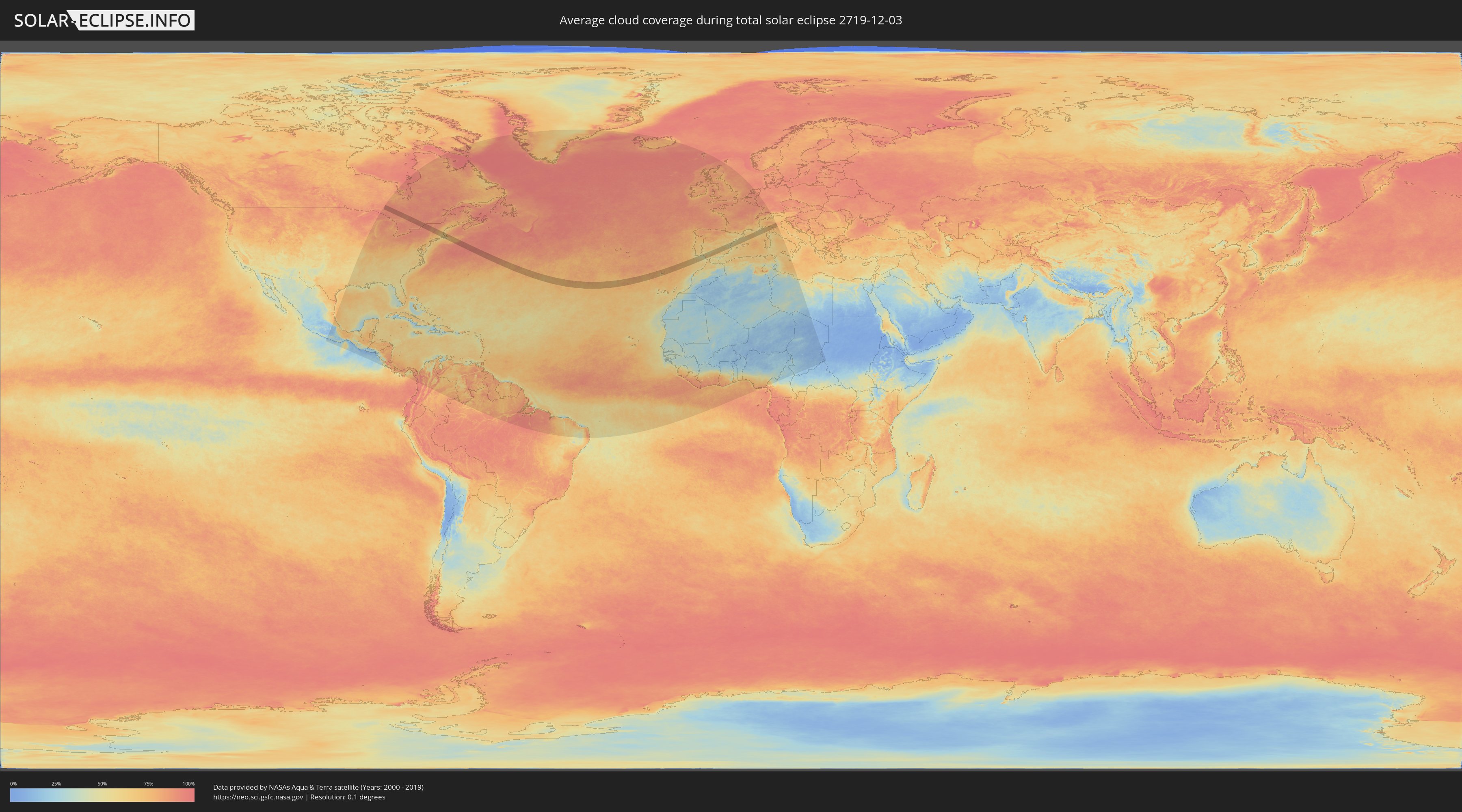
Wie wird das Wetter während der totalen Sonnenfinsternis am 03.12.2719?
Wo ist der beste Ort, um die totale Sonnenfinsternis vom 03.12.2719 zu beobachten?
Die folgenden Karten zeigen die durchschnittliche Bewölkung für den Tag, an dem die totale Sonnenfinsternis
stattfindet. Mit Hilfe der Karten lässt sich der Ort entlang des Finsternispfades eingrenzen,
der die besten Aussichen auf einen klaren wolkenfreien Himmel bietet.
Trotzdem muss man immer lokale Gegenenheiten beachten und sollte sich genau über das Wetter an seinem
gewählten Beobachtungsort informieren.
Die Daten stammen von den beiden NASA-Satelliten
AQUA und TERRA
und wurden über einen Zeitraum von 19 Jahren (2000 - 2019) gemittelt.
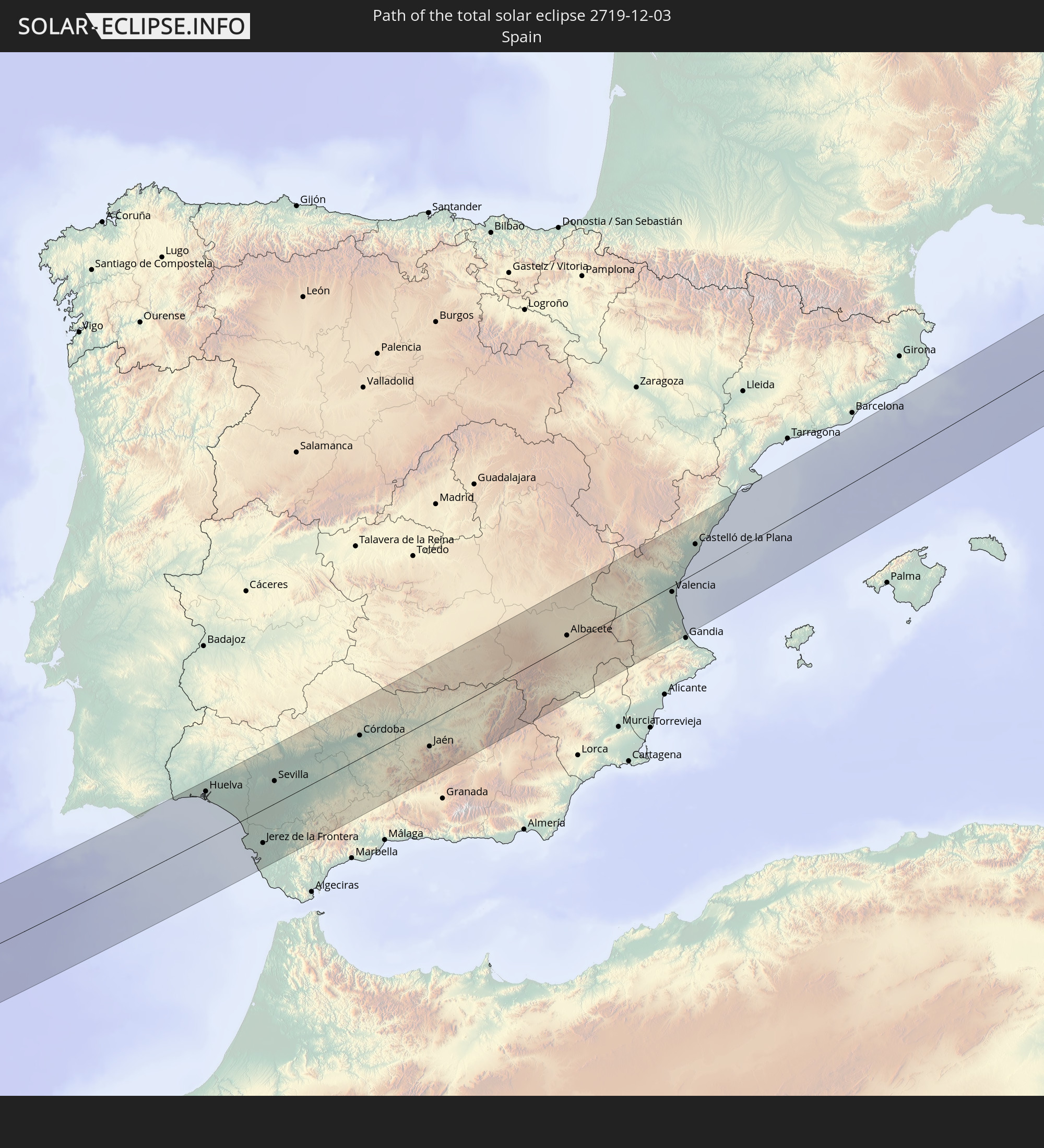
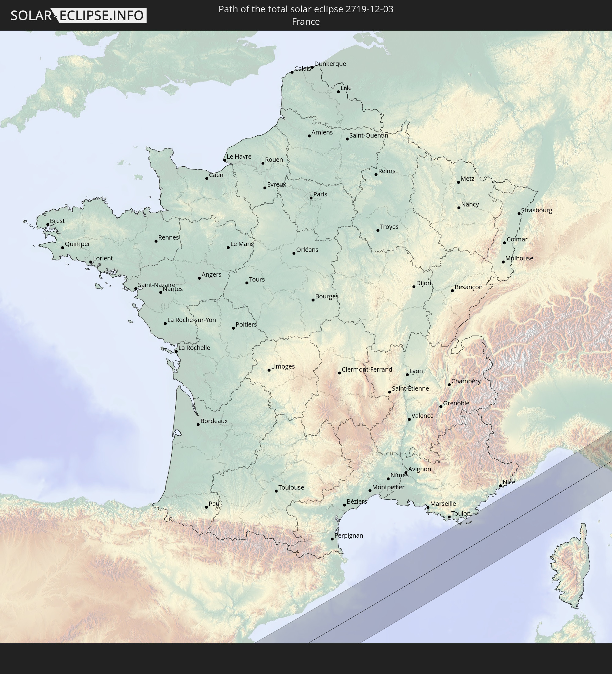
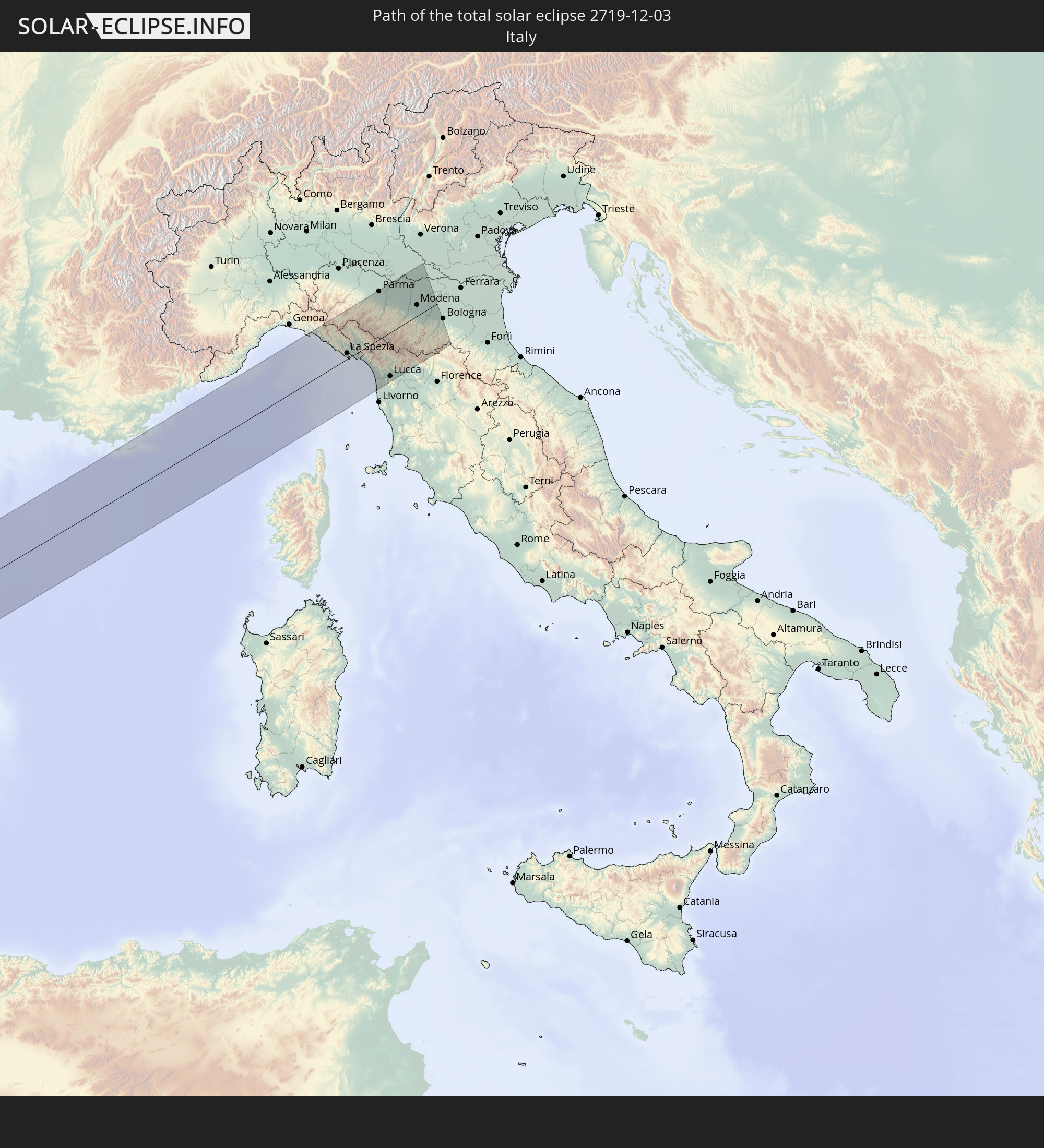
Detaillierte Länderkarten
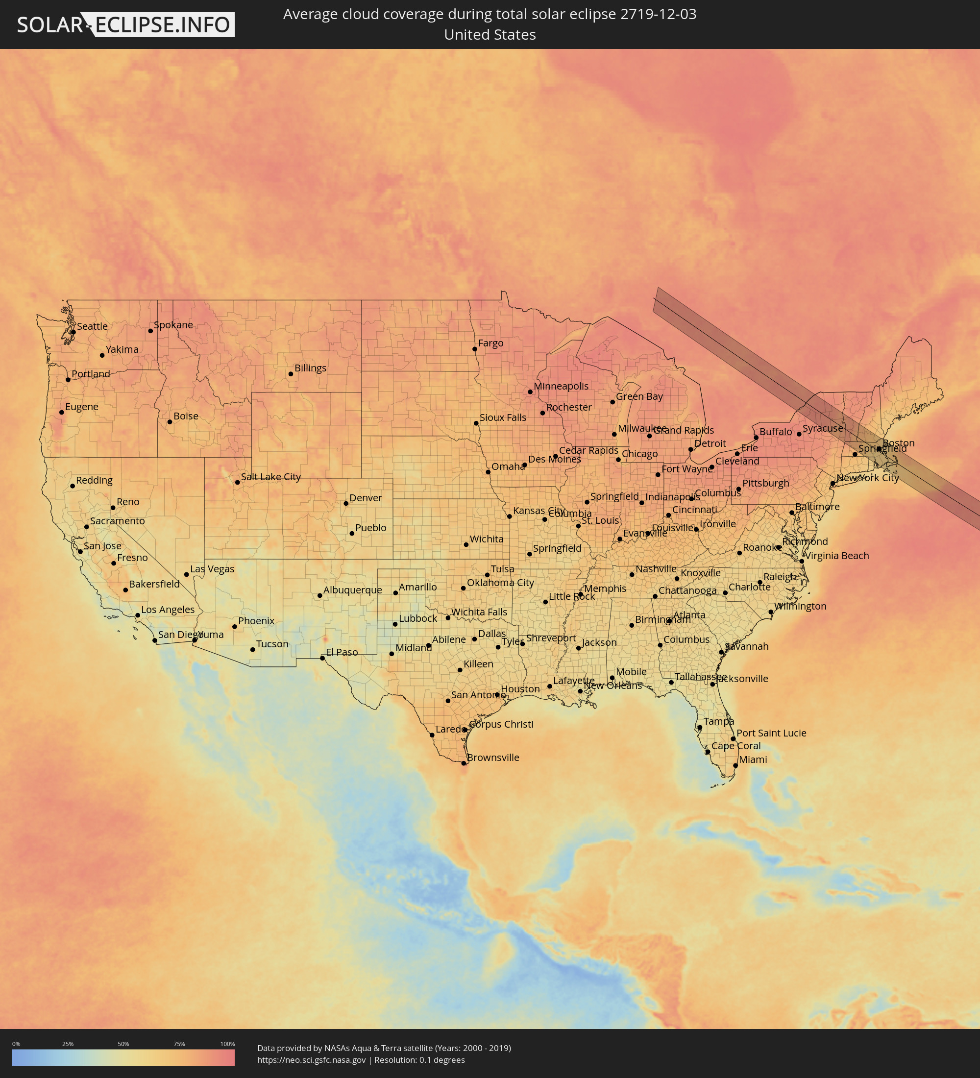 Vereinigte Staaten
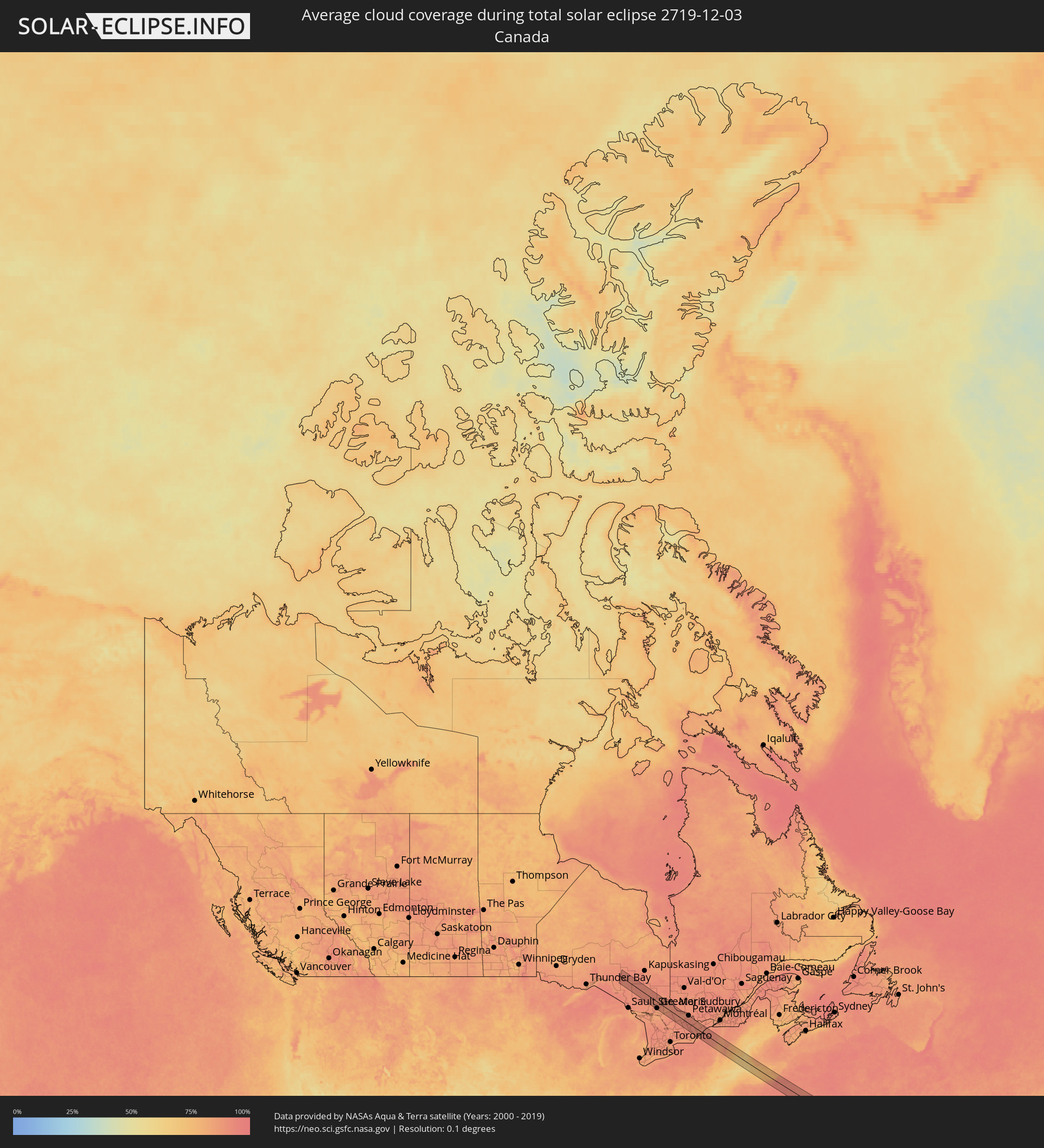 Kanada
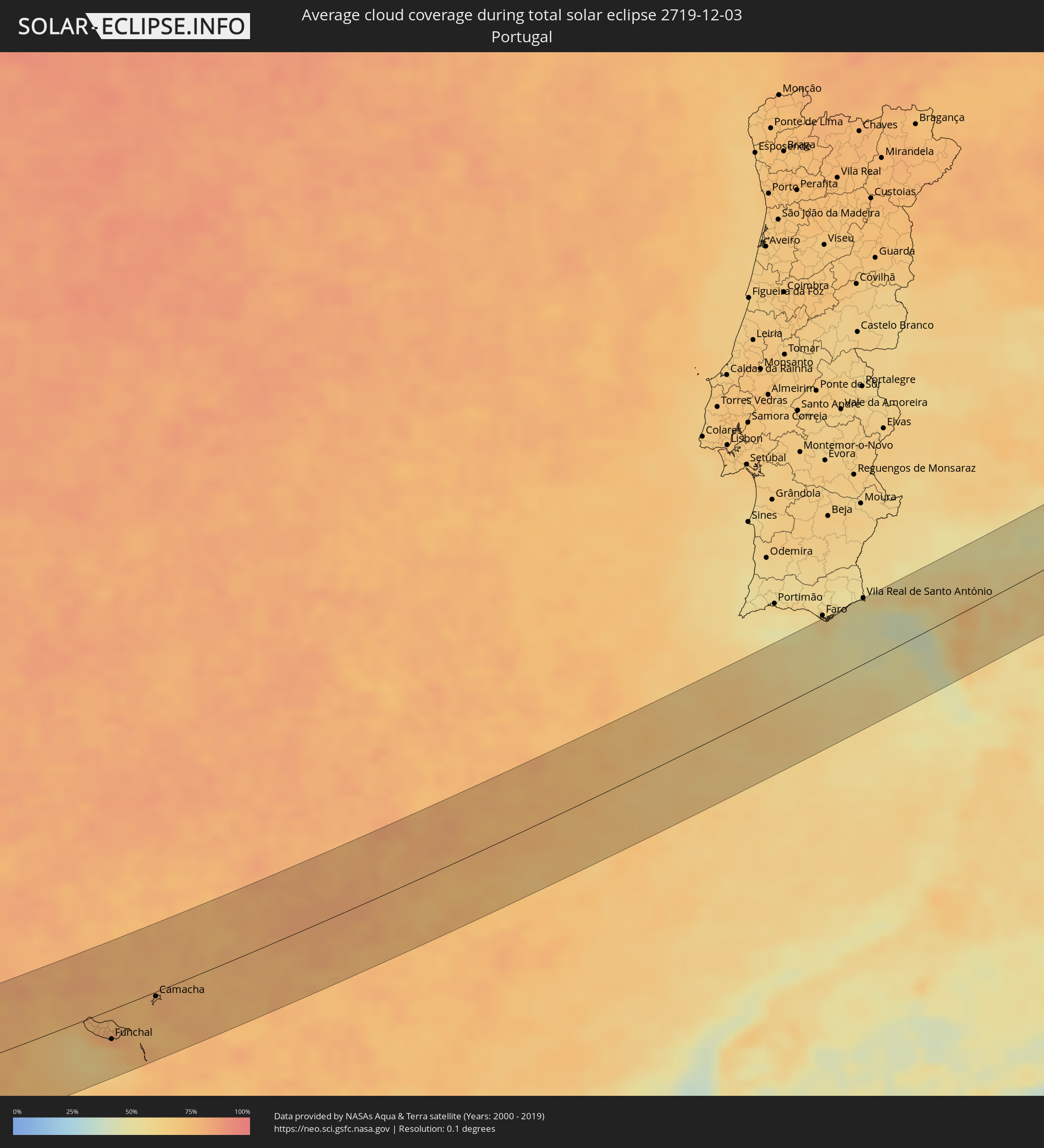 Portugal
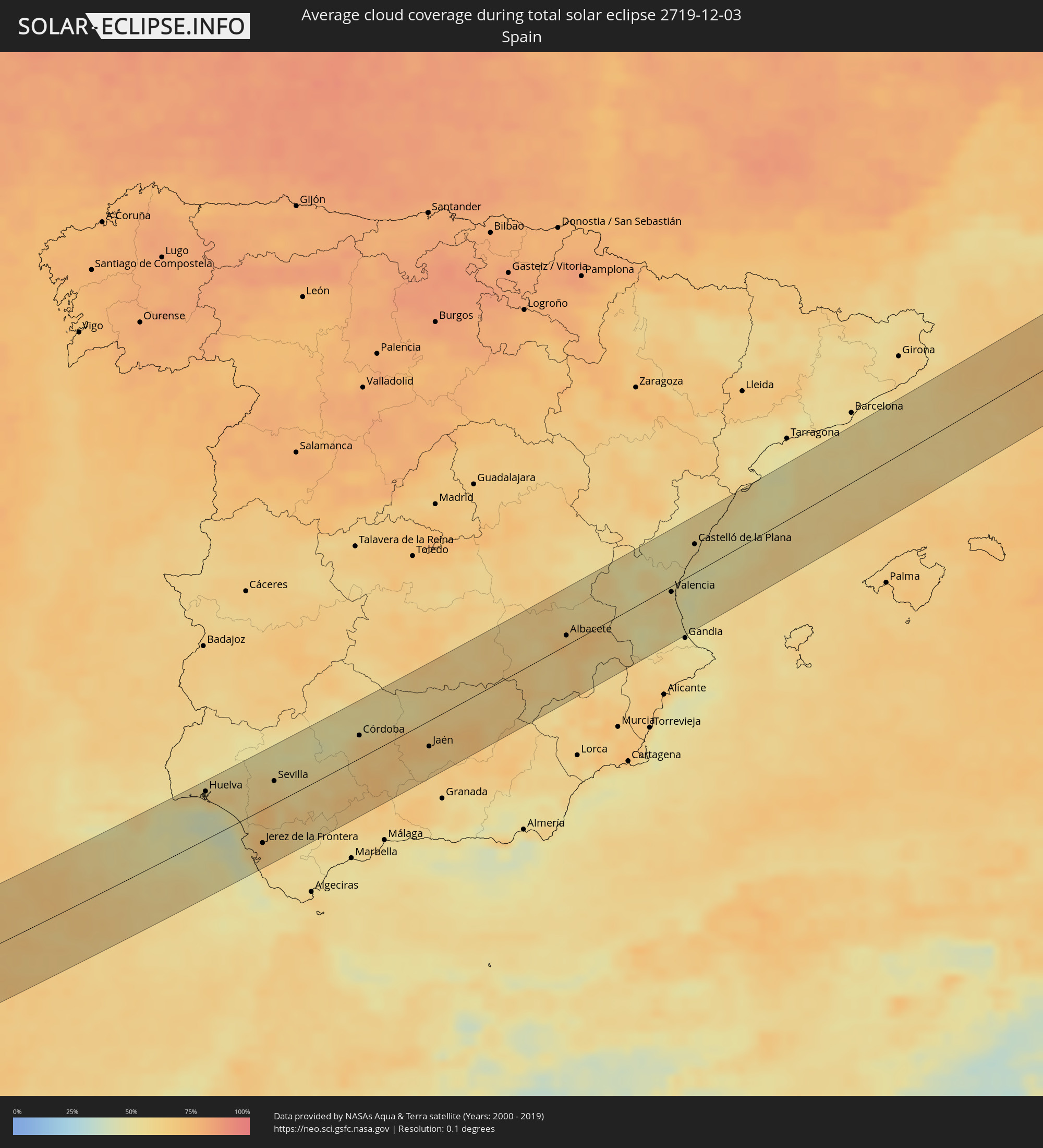 Spanien
 Frankreich
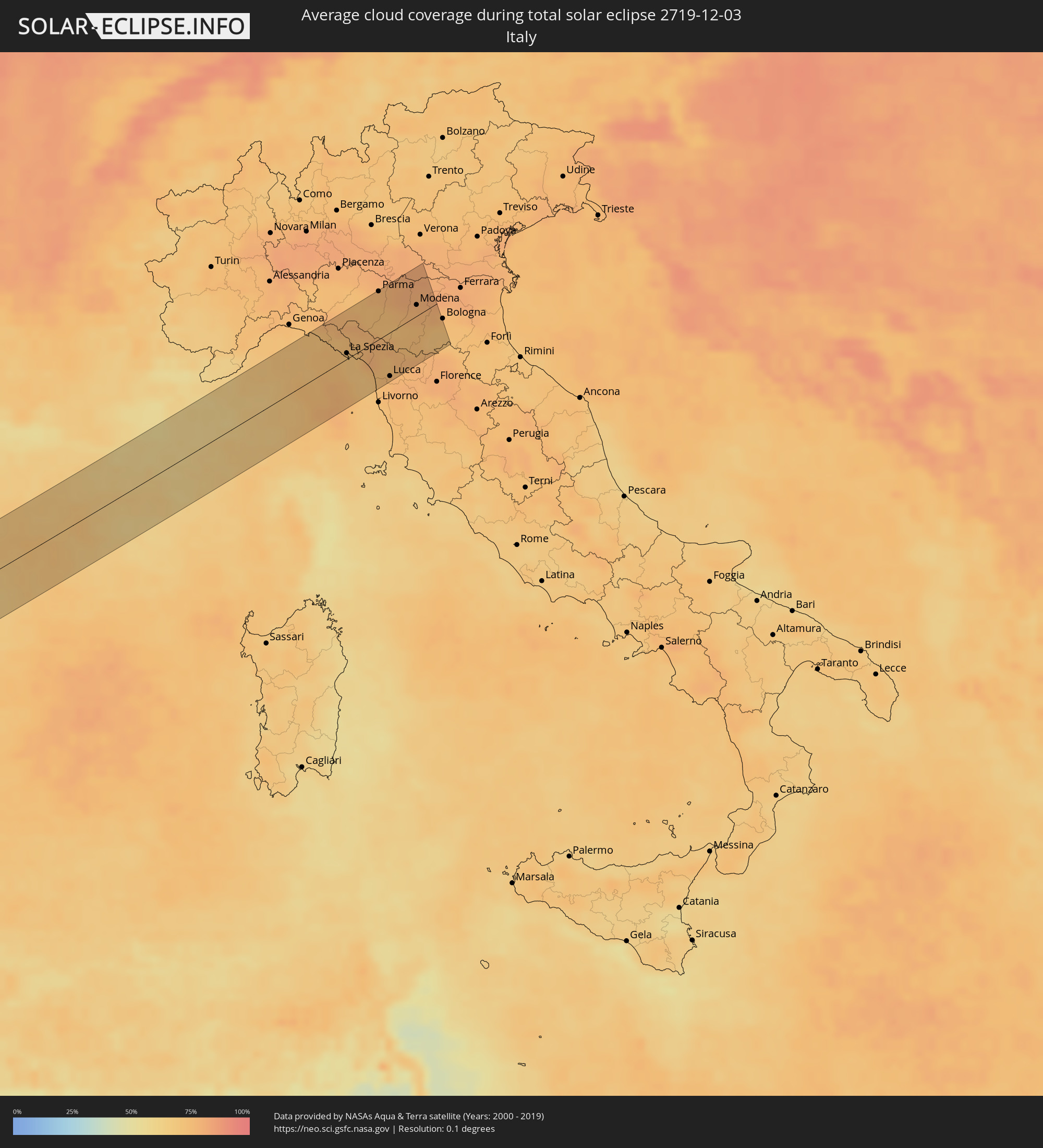 Italien
Orte im Finsternispfad
Die nachfolgene Tabelle zeigt Städte und Orte mit mehr als 5.000 Einwohnern, die sich im Finsternispfad befinden. Städte mit mehr als 100.000 Einwohnern sind dick gekennzeichnet. Mit einem Klick auf den Ort öffnet sich eine Detailkarte die die Lage des jeweiligen Ortes zusammen mit dem Verlauf der zentralen Finsternis präsentiert.
| Ort | Typ | Dauer der Verfinsterung | Ortszeit bei maximaler Verfinsterung | Entfernung zur Zentrallinie | Ø Bewölkung |
|
Rayside-Balfour, Ontario
|
total | - | 08:20:36 UTC-05:00 | 47 km | 88% |
|
Greater Sudbury, Ontario
|
total | - | 08:20:37 UTC-05:00 | 48 km | 85% |
|
North Bay, Ontario
|
total | - | 08:21:31 UTC-05:00 | 2 km | 86% |
|
Renfrew, Ontario
|
total | - | 08:22:49 UTC-05:00 | 46 km | 90% |
|
Arnprior, Ontario
|
total | - | 08:23:03 UTC-05:00 | 58 km | 87% |
|
Perth, Ontario
|
total | - | 08:22:35 UTC-05:00 | 13 km | 89% |
|
Gananoque, Ontario
|
total | - | 08:22:04 UTC-05:00 | 36 km | 87% |
|
Carleton Place, Ontario
|
total | - | 08:22:55 UTC-05:00 | 39 km | 89% |
|
Smiths Falls, Ontario
|
total | - | 08:22:47 UTC-05:00 | 23 km | 90% |
|
Watertown, New York
|
total | - | 08:21:56 UTC-05:00 | 57 km | 91% |
|
Brockville, Ontario
|
total | - | 08:22:45 UTC-05:00 | 9 km | 90% |
|
Saratoga Springs, New York
|
total | - | 08:23:01 UTC-05:00 | 45 km | 82% |
|
Glens Falls, New York
|
total | - | 08:23:22 UTC-05:00 | 18 km | 81% |
|
North Adams, Massachusetts
|
total | - | 08:23:19 UTC-05:00 | 50 km | 85% |
|
Rutland, Vermont
|
total | - | 08:24:19 UTC-05:00 | 40 km | 85% |
|
Greenfield, Massachusetts
|
total | - | 08:23:43 UTC-05:00 | 38 km | 78% |
|
Amherst Center, Massachusetts
|
total | - | 08:23:36 UTC-05:00 | 54 km | 77% |
|
Claremont, New Hampshire
|
total | - | 08:24:43 UTC-05:00 | 47 km | 81% |
|
Keene, New Hampshire
|
total | - | 08:24:22 UTC-05:00 | 9 km | 79% |
|
Southbridge, Massachusetts
|
total | - | 08:23:50 UTC-05:00 | 60 km | 68% |
|
Gardner, Massachusetts
|
total | - | 08:24:20 UTC-05:00 | 12 km | 71% |
|
Worcester, Massachusetts
|
total | - | 08:24:14 UTC-05:00 | 32 km | 69% |
|
Leominster, Massachusetts
|
total | - | 08:24:32 UTC-05:00 | 6 km | 68% |
|
Hudson, Massachusetts
|
total | - | 08:24:36 UTC-05:00 | 9 km | 68% |
|
Milford, Massachusetts
|
total | - | 08:24:26 UTC-05:00 | 31 km | 65% |
|
Woonsocket, Rhode Island
|
total | - | 08:24:18 UTC-05:00 | 43 km | 64% |
|
Nashua, New Hampshire
|
total | - | 08:25:03 UTC-05:00 | 30 km | 73% |
|
Manchester, New Hampshire
|
total | - | 08:25:17 UTC-05:00 | 52 km | 74% |
|
Acton, Massachusetts
|
total | - | 08:24:50 UTC-05:00 | 5 km | 67% |
|
Framingham, Massachusetts
|
total | - | 08:24:40 UTC-05:00 | 13 km | 64% |
|
Providence, Rhode Island
|
total | - | 08:24:15 UTC-05:00 | 55 km | 64% |
|
Lowell, Massachusetts
|
total | - | 08:25:06 UTC-05:00 | 24 km | 69% |
|
Derry Village, New Hampshire
|
total | - | 08:25:20 UTC-05:00 | 49 km | 72% |
|
Attleboro, Massachusetts
|
total | - | 08:24:30 UTC-05:00 | 38 km | 64% |
|
Needham, Massachusetts
|
total | - | 08:24:52 UTC-05:00 | 4 km | 63% |
|
Fall River, Massachusetts
|
total | - | 08:24:25 UTC-05:00 | 55 km | 62% |
|
Woburn, Massachusetts
|
total | - | 08:25:08 UTC-05:00 | 18 km | 66% |
|
Taunton, Massachusetts
|
total | - | 08:24:40 UTC-05:00 | 34 km | 63% |
|
Haverhill, Massachusetts
|
total | - | 08:25:29 UTC-05:00 | 48 km | 69% |
|
Boston, Massachusetts
|
total | - | 08:25:07 UTC-05:00 | 10 km | 65% |
|
Brockton, Massachusetts
|
total | - | 08:24:55 UTC-05:00 | 13 km | 64% |
|
Lynn, Massachusetts
|
total | - | 08:25:20 UTC-05:00 | 26 km | 64% |
|
Weymouth, Massachusetts
|
total | - | 08:25:07 UTC-05:00 | 3 km | 64% |
|
New Bedford, Massachusetts
|
total | - | 08:24:36 UTC-05:00 | 51 km | 63% |
|
Newburyport, Massachusetts
|
total | - | 08:25:44 UTC-05:00 | 61 km | 66% |
|
Hanover, Massachusetts
|
total | - | 08:25:10 UTC-05:00 | 1 km | 64% |
|
Gloucester, Massachusetts
|
total | - | 08:25:47 UTC-05:00 | 52 km | 65% |
|
Mashpee, Massachusetts
|
total | - | 08:25:07 UTC-05:00 | 29 km | 61% |
|
Barnstable, Massachusetts
|
total | - | 08:25:21 UTC-05:00 | 16 km | 63% |
|
Harwich, Massachusetts
|
total | - | 08:25:36 UTC-05:00 | 8 km | 66% |
|
Ribeira Brava, Madeira
|
total | - | 15:09:44 UTC+00:00 | 25 km | 75% |
|
São Vicente, Madeira
|
total | - | 15:09:41 UTC+00:00 | 11 km | 79% |
|
Câmara de Lobos, Madeira
|
total | - | 15:09:56 UTC+00:00 | 30 km | 65% |
|
Nossa Senhora do Monte, Madeira
|
total | - | 15:10:02 UTC+00:00 | 29 km | 79% |
|
Funchal, Madeira
|
total | - | 15:10:03 UTC+00:00 | 33 km | 69% |
|
Santana, Madeira
|
total | - | 15:09:58 UTC+00:00 | 16 km | 80% |
|
Caniço, Madeira
|
total | - | 15:10:09 UTC+00:00 | 34 km | 69% |
|
Camacha, Madeira
|
total | - | 15:10:08 UTC+00:00 | 30 km | 78% |
|
Santa Cruz, Madeira
|
total | - | 15:10:12 UTC+00:00 | 31 km | 78% |
|
Machico, Madeira
|
total | - | 15:10:15 UTC+00:00 | 30 km | 78% |
|
Camacha, Madeira
|
total | - | 15:10:45 UTC+00:00 | 5 km | 78% |
|
Vila Real de Santo António, Faro
|
total | - | 15:21:12 UTC+00:00 | 66 km | 51% |
|
Lepe, Andalusia
|
total | - | 16:21:26 UTC+01:00 | 63 km | 59% |
|
Huelva, Andalusia
|
total | - | 16:21:46 UTC+01:00 | 53 km | 63% |
|
Sanlúcar de Barrameda, Andalusia
|
total | - | 16:22:59 UTC+01:00 | 19 km | 56% |
|
Cadiz, Andalusia
|
total | - | 16:23:18 UTC+01:00 | 46 km | 48% |
|
Chiclana de la Frontera, Andalusia
|
total | - | 16:23:35 UTC+01:00 | 63 km | 58% |
|
Jerez de la Frontera, Andalusia
|
total | - | 16:23:21 UTC+01:00 | 37 km | 66% |
|
Lebrija, Andalusia
|
total | - | 16:23:12 UTC+01:00 | 17 km | 69% |
|
Sevilla, Andalusia
|
total | - | 16:22:53 UTC+01:00 | 25 km | 62% |
|
Arcos de la Frontera, Andalusia
|
total | - | 16:23:42 UTC+01:00 | 44 km | 63% |
|
Utrera, Andalusia
|
total | - | 16:23:19 UTC+01:00 | 3 km | 64% |
|
Carmona, Andalusia
|
total | - | 16:23:12 UTC+01:00 | 20 km | 57% |
|
Morón de la Frontera, Andalusia
|
total | - | 16:23:47 UTC+01:00 | 23 km | 67% |
|
Écija, Andalusia
|
total | - | 16:23:49 UTC+01:00 | 4 km | 63% |
|
Córdoba, Andalusia
|
total | - | 16:23:50 UTC+01:00 | 25 km | 64% |
|
Puente-Genil, Andalusia
|
total | - | 16:24:21 UTC+01:00 | 25 km | 66% |
|
Montilla, Andalusia
|
total | - | 16:24:18 UTC+01:00 | 11 km | 69% |
|
Lucena, Andalusia
|
total | - | 16:24:40 UTC+01:00 | 34 km | 73% |
|
Priego de Córdoba, Andalusia
|
total | - | 16:24:58 UTC+01:00 | 44 km | 66% |
|
Andújar, Andalusia
|
total | - | 16:24:32 UTC+01:00 | 9 km | 72% |
|
Martos, Andalusia
|
total | - | 16:24:57 UTC+01:00 | 25 km | 63% |
|
Alcalá la Real, Andalusia
|
total | - | 16:25:16 UTC+01:00 | 53 km | 65% |
|
Jaén, Andalusia
|
total | - | 16:25:07 UTC+01:00 | 28 km | 66% |
|
Linares, Andalusia
|
total | - | 16:24:57 UTC+01:00 | 3 km | 65% |
|
Valdepeñas, Castille-La Mancha
|
total | - | 16:24:34 UTC+01:00 | 52 km | 62% |
|
Úbeda, Andalusia
|
total | - | 16:25:20 UTC+01:00 | 22 km | 72% |
|
Campiña, Andalusia
|
total | - | 16:25:34 UTC+01:00 | 18 km | 65% |
|
Albacete, Castille-La Mancha
|
total | - | 16:25:59 UTC+01:00 | 10 km | 70% |
|
Hellín, Castille-La Mancha
|
total | - | 16:26:39 UTC+01:00 | 43 km | 67% |
|
Yecla, Murcia
|
total | - | 16:27:09 UTC+01:00 | 58 km | 60% |
|
Almansa, Castille-La Mancha
|
total | - | 16:26:54 UTC+01:00 | 34 km | 65% |
|
Ontinyent, Valencia
|
total | - | 16:27:27 UTC+01:00 | 59 km | 58% |
|
Llíria, Valencia
|
total | - | 16:26:36 UTC+01:00 | 19 km | 58% |
|
Xàtiva, Valencia
|
total | - | 16:27:21 UTC+01:00 | 47 km | 59% |
|
Alzira, Valencia
|
total | - | 16:27:16 UTC+01:00 | 35 km | 55% |
|
Valencia, Valencia
|
total | - | 16:26:59 UTC+01:00 | 6 km | 61% |
|
Sagunto, Valencia
|
total | - | 16:26:52 UTC+01:00 | 10 km | 54% |
|
Onda, Valencia
|
total | - | 16:26:34 UTC+01:00 | 37 km | 50% |
|
Cullera, Valencia
|
total | - | 16:27:26 UTC+01:00 | 41 km | 54% |
|
Castelló de la Plana, Valencia
|
total | - | 16:26:45 UTC+01:00 | 30 km | 56% |
|
Vinaròs, Valencia
|
total | - | 16:26:43 UTC+01:00 | 54 km | 56% |
|
Chiavari, Liguria
|
total | - | 16:29:02 UTC+01:00 | 48 km | 72% |
|
La Spezia, Liguria
|
total | - | 16:29:36 UTC+01:00 | 6 km | 71% |
|
Santo Stefano di Magra, Liguria
|
total | - | 16:29:37 UTC+01:00 | 6 km | 71% |
|
Colombiera-Molicciara, Liguria
|
total | - | 16:29:44 UTC+01:00 | 3 km | 71% |
|
Casano-Dogana-Isola, Liguria
|
total | - | 16:29:46 UTC+01:00 | 5 km | 71% |
|
Massa, Tuscany
|
total | - | 16:29:53 UTC+01:00 | 13 km | 72% |
|
Forte dei Marmi, Tuscany
|
total | - | 16:29:59 UTC+01:00 | 22 km | 74% |
|
Collecchio, Emilia-Romagna
|
total | - | 16:29:02 UTC+01:00 | 51 km | 76% |
|
Viareggio, Tuscany
|
total | - | 16:30:09 UTC+01:00 | 34 km | 73% |
|
Parma, Emilia-Romagna
|
total | - | 16:29:02 UTC+01:00 | 51 km | 76% |
|
Vecchiano-Nodica, Tuscany
|
total | - | 16:30:20 UTC+01:00 | 48 km | 75% |
|
Castelnovo ne'Monti, Emilia-Romagna
|
total | - | 16:29:32 UTC+01:00 | 13 km | 72% |
|
Pontasserchio, Tuscany
|
total | - | 16:30:21 UTC+01:00 | 49 km | 75% |
|
Sorbolo, Emilia-Romagna
|
total | - | 16:29:03 UTC+01:00 | 51 km | 77% |
|
Sant'Ilario d'Enza, Emilia-Romagna
|
total | - | 16:29:09 UTC+01:00 | 42 km | 77% |
|
Lucca, Tuscany
|
total | - | 16:30:20 UTC+01:00 | 47 km | 75% |
|
Castelnovo di Sotto, Emilia-Romagna
|
total | - | 16:29:09 UTC+01:00 | 42 km | 79% |
|
Cadelbosco di Sopra, Emilia-Romagna
|
total | - | 16:29:14 UTC+01:00 | 37 km | 79% |
|
Porcari, Tuscany
|
total | - | 16:30:24 UTC+01:00 | 52 km | 77% |
|
Reggio nell'Emilia, Emilia-Romagna
|
total | - | 16:29:20 UTC+01:00 | 29 km | 76% |
|
Bagnolo in Piano, Emilia-Romagna
|
total | - | 16:29:17 UTC+01:00 | 35 km | 80% |
|
Pescia, Tuscany
|
total | - | 16:30:23 UTC+01:00 | 50 km | 76% |
|
Casalgrande, Emilia-Romagna
|
total | - | 16:29:32 UTC+01:00 | 14 km | 75% |
|
Suzzara, Lombardy
|
total | - | 16:29:02 UTC+01:00 | 52 km | 79% |
|
Sassuolo, Emilia-Romagna
|
total | - | 16:29:37 UTC+01:00 | 8 km | 74% |
|
Fabbrico, Emilia-Romagna
|
total | - | 16:29:13 UTC+01:00 | 38 km | 80% |
|
Reggiolo, Emilia-Romagna
|
total | - | 16:29:10 UTC+01:00 | 42 km | 80% |
|
Pavullo nel Frignano, Emilia-Romagna
|
total | - | 16:29:55 UTC+01:00 | 14 km | 74% |
|
Campogalliano, Emilia-Romagna
|
total | - | 16:29:28 UTC+01:00 | 19 km | 78% |
|
Carpi Centro, Emilia-Romagna
|
total | - | 16:29:22 UTC+01:00 | 27 km | 79% |
|
Modena, Emilia-Romagna
|
total | - | 16:29:34 UTC+01:00 | 12 km | 76% |
|
Castelnuovo Rangone, Emilia-Romagna
|
total | - | 16:29:42 UTC+01:00 | 5 km | 74% |
|
Vignola, Emilia-Romagna
|
total | - | 16:29:49 UTC+01:00 | 8 km | 74% |
|
Mirandola, Emilia-Romagna
|
total | - | 16:29:21 UTC+01:00 | 28 km | 80% |
|
Bazzano, Emilia-Romagna
|
total | - | 16:29:50 UTC+01:00 | 9 km | 74% |
|
San Felice sul Panaro, Emilia-Romagna
|
total | - | 16:29:27 UTC+01:00 | 21 km | 80% |
|
San Giovanni in Persiceto, Emilia-Romagna
|
total | - | 16:29:43 UTC+01:00 | 0 km | 78% |
|
Sasso Marconi, Emilia-Romagna
|
total | - | 16:30:03 UTC+01:00 | 25 km | 71% |
|
Calderara di Reno, Emilia-Romagna
|
total | - | 16:29:52 UTC+01:00 | 11 km | 76% |
|
Casalecchio di Reno, Emilia-Romagna
|
total | - | 16:29:59 UTC+01:00 | 19 km | 73% |