Totale Sonnenfinsternis vom 24.11.2747
| Wochentag: | Montag |
| Maximale Dauer der Verfinsterung: | 03m49s |
| Maximale Breite des Finsternispfades: | 147 km |
| Saroszyklus: | 164 |
| Bedeckungsgrad: | 100% |
| Magnitude: | 1.0438 |
| Gamma: | -0.094 |
Wo kann man die Sonnenfinsternis vom 24.11.2747 sehen?
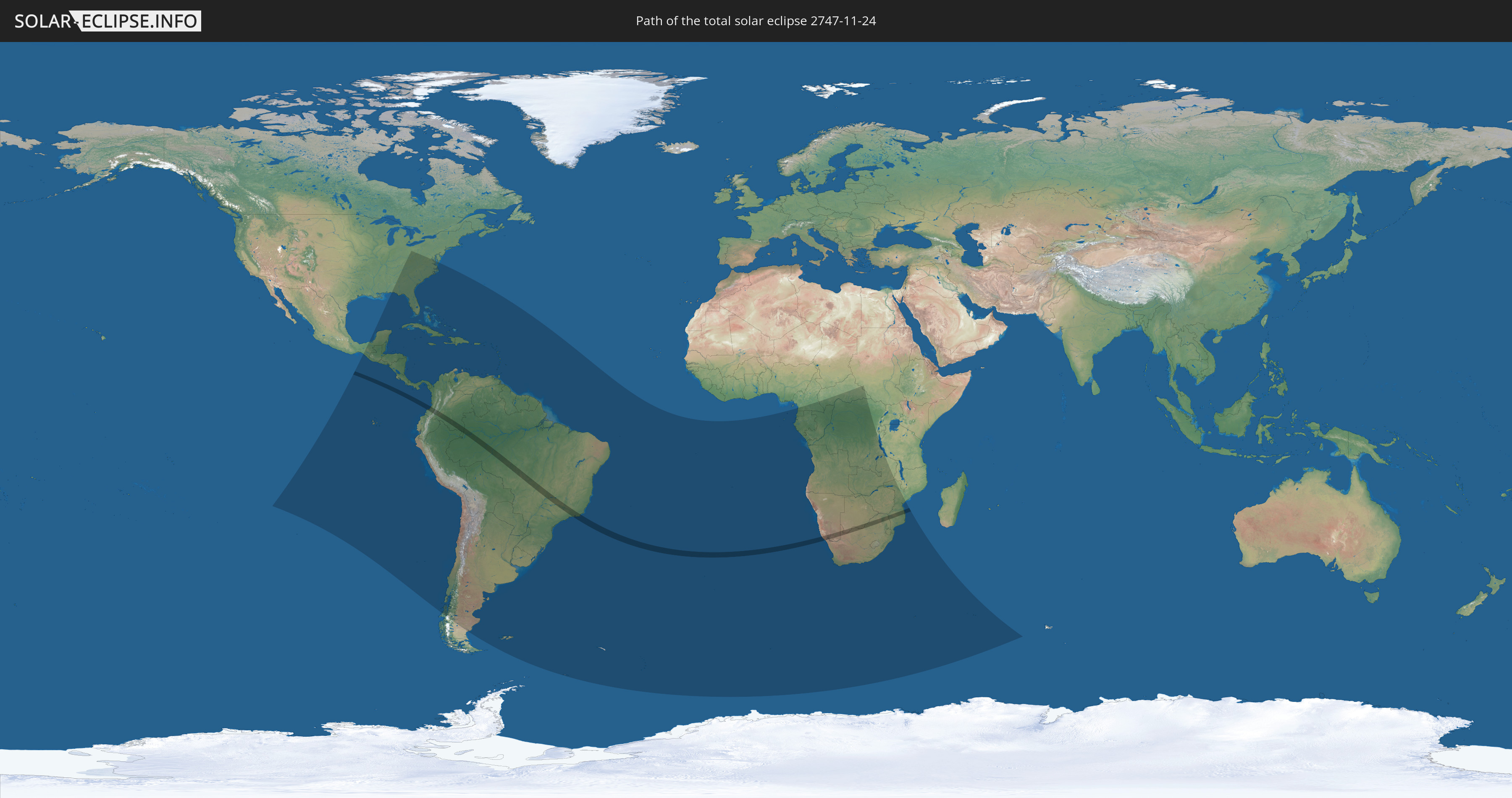
Die Sonnenfinsternis am 24.11.2747 kann man in 72 Ländern als partielle Sonnenfinsternis beobachten.
Der Finsternispfad verläuft durch 7 Länder. Nur in diesen Ländern ist sie als totale Sonnenfinsternis zu sehen.
In den folgenden Ländern ist die Sonnenfinsternis total zu sehen
 Kolumbien
 Peru
Peru
 Brasilien
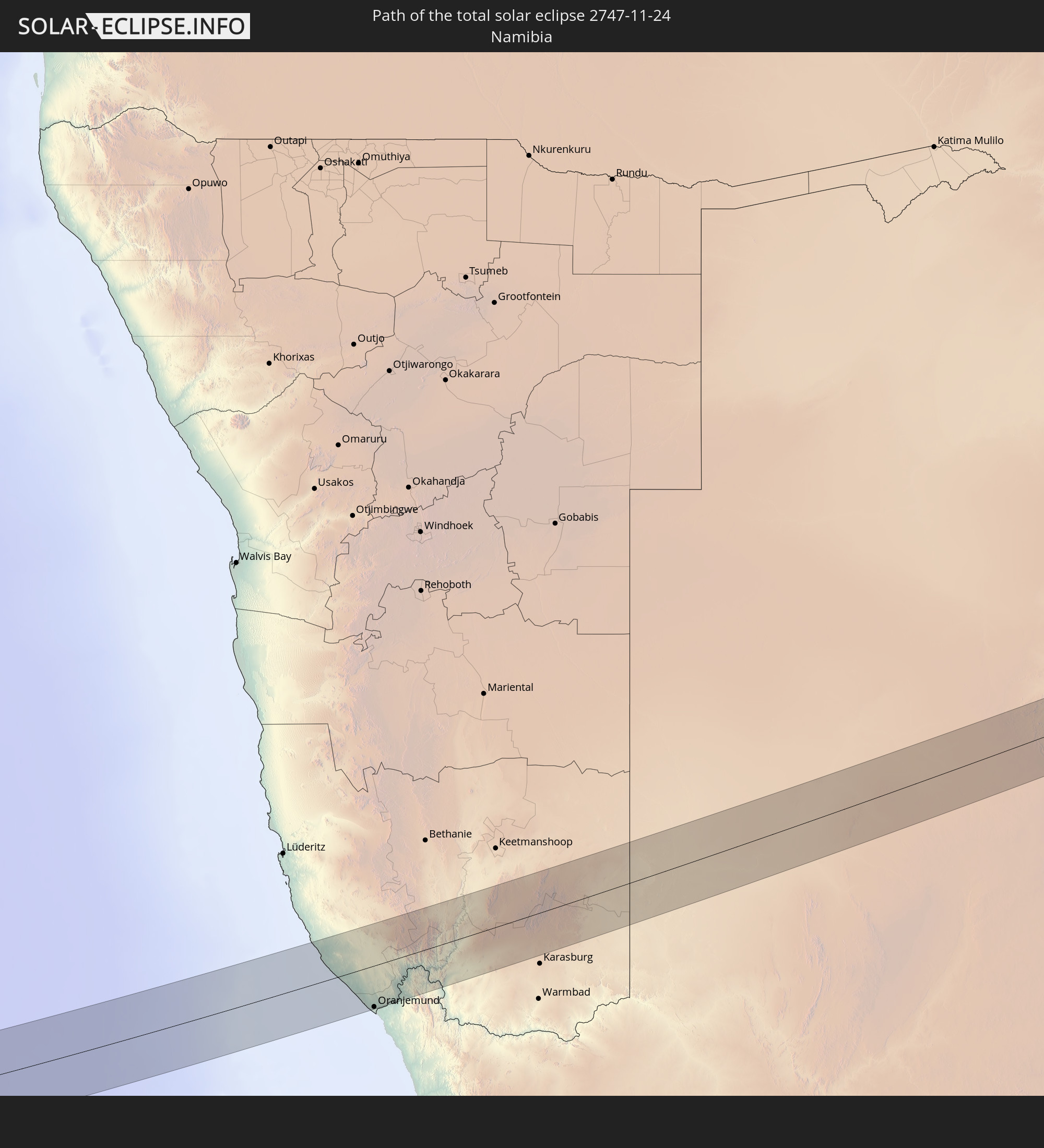 Namibia
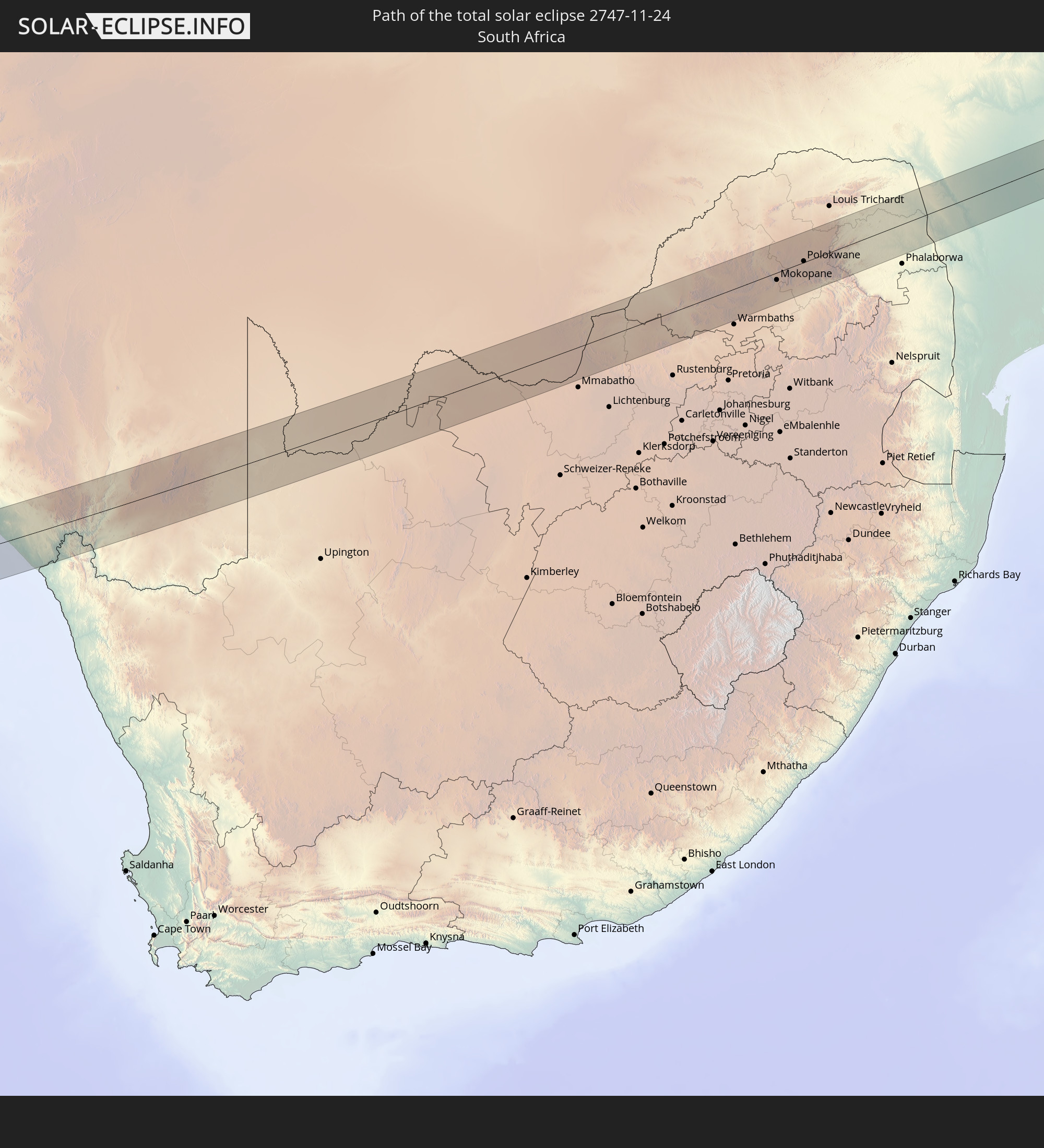 Südafrika
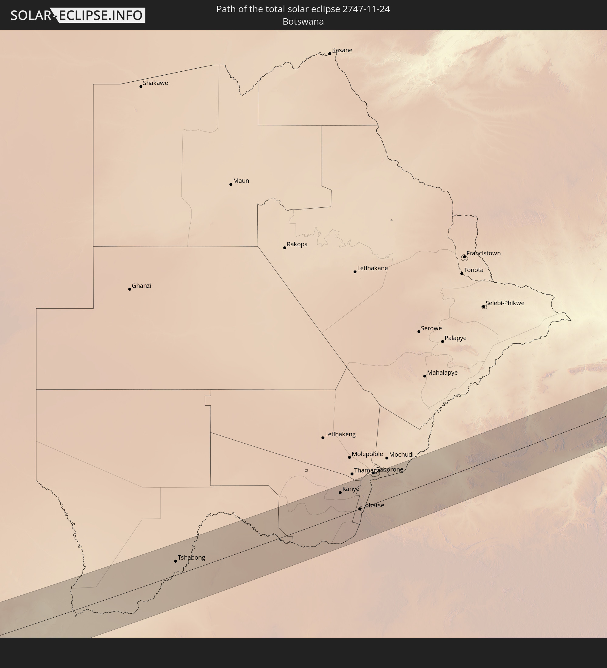 Botswana
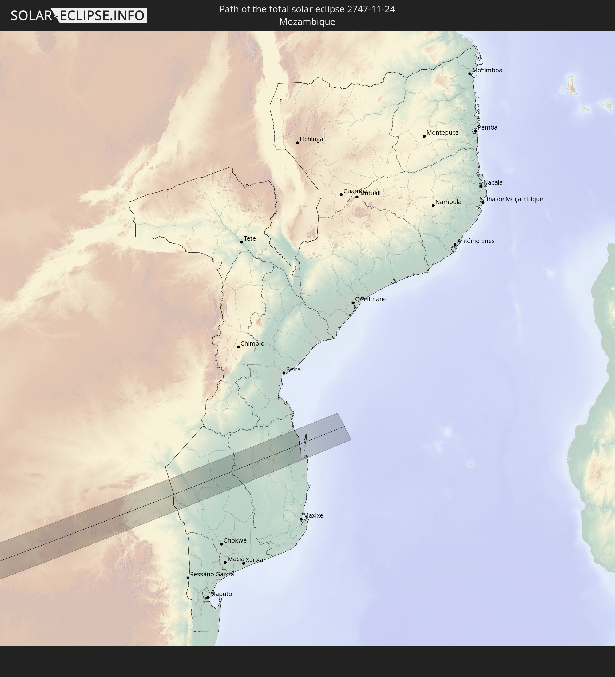 Mosambik
In den folgenden Ländern ist die Sonnenfinsternis partiell zu sehen
 Antarktika
 Vereinigte Staaten
 United States Minor Outlying Islands
 Mexiko
 Chile
Chile
 Guatemala
 Ecuador
 El Salvador
 Honduras
 Belize
 Nicaragua
 Costa Rica
 Kuba
Kuba
 Panama
 Kolumbien
 Kaimaninseln
 Peru
Peru
 Bahamas
 Jamaika
 Haiti
Haiti
 Brasilien
 Argentinien
 Venezuela
 Turks- und Caicosinseln
 Dominikanische Republik
 Aruba
Aruba
 Bolivien
 Puerto Rico
 Amerikanische Jungferninseln
 Britische Jungferninseln
 Anguilla
 Saint-Martin
 Saint-Barthélemy
 St. Kitts und Nevis
 Paraguay
 Antigua und Barbuda
 Montserrat
 Trinidad und Tobago
 Guadeloupe
 Grenada
 Dominica
 St. Vincent und die Grenadinen
 Falklandinseln
 Guyana
 Martinique
 St. Lucia
 Barbados
 Uruguay
 Suriname
 Französisch-Guayana
 Südgeorgien und die Südlichen Sandwichinseln
 St. Helena
 Bouvetinsel
 Äquatorialguinea
 São Tomé und Príncipe
 Kamerun
 Gabun
Gabun
 Republik Kongo
 Angola
 Namibia
 Demokratische Republik Kongo
 Zentralafrikanische Republik
 Südafrika
 Botswana
 Sambia
 Simbabwe
 Lesotho
 Tansania
 Mosambik
 Swasiland
 Malawi
 Französische Süd- und Antarktisgebiete
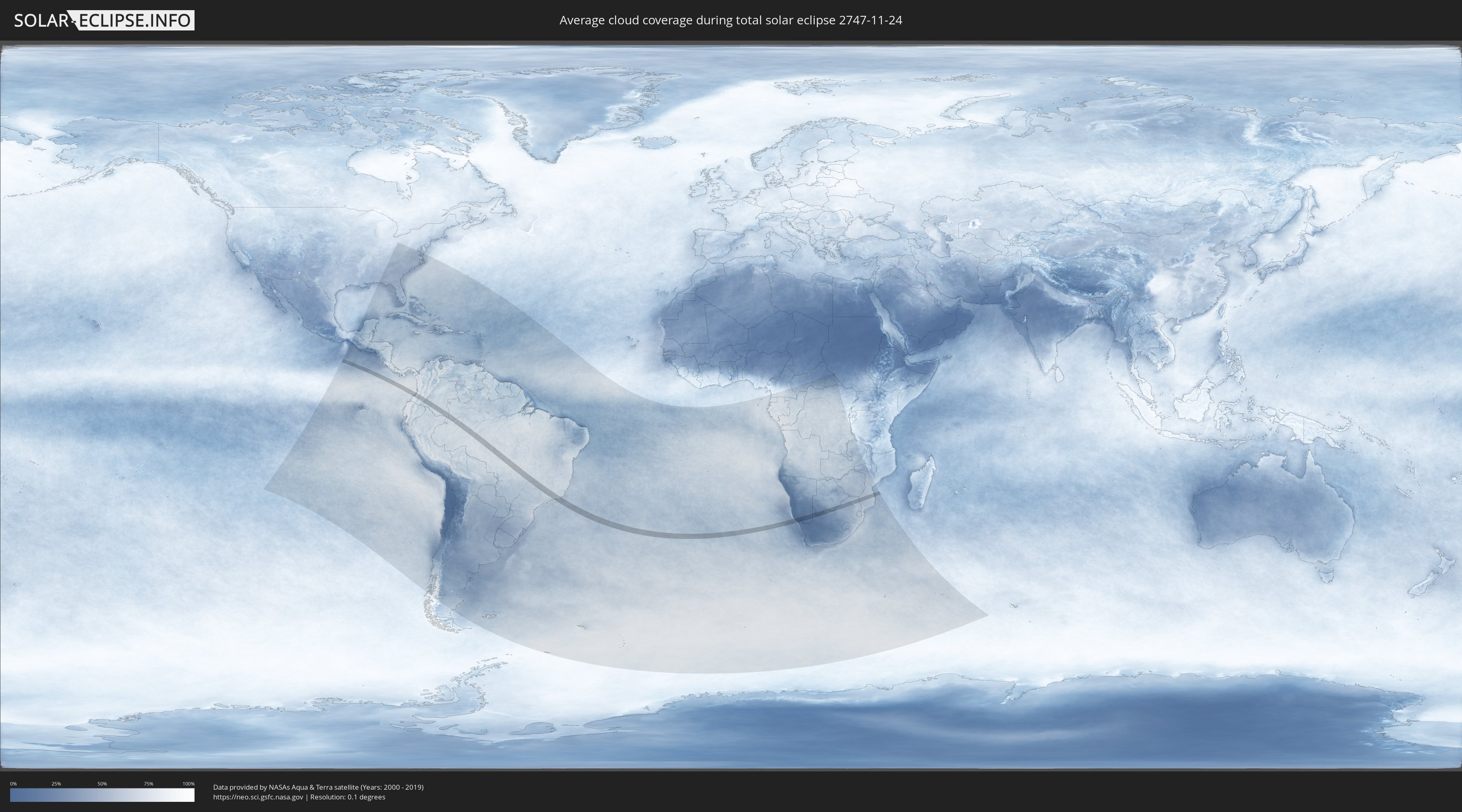
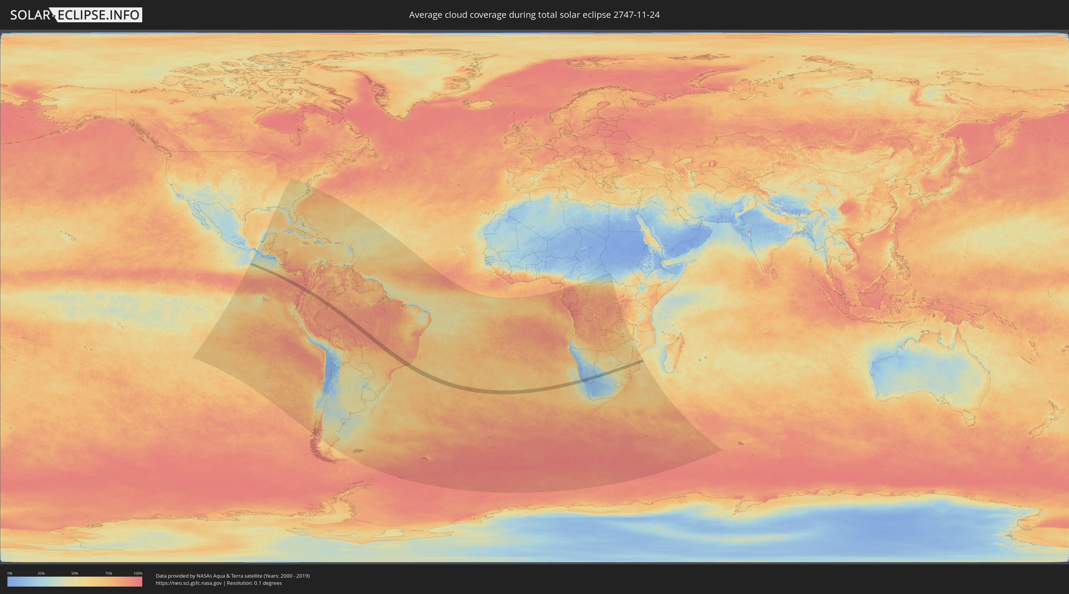
Wie wird das Wetter während der totalen Sonnenfinsternis am 24.11.2747?
Wo ist der beste Ort, um die totale Sonnenfinsternis vom 24.11.2747 zu beobachten?
Die folgenden Karten zeigen die durchschnittliche Bewölkung für den Tag, an dem die totale Sonnenfinsternis
stattfindet. Mit Hilfe der Karten lässt sich der Ort entlang des Finsternispfades eingrenzen,
der die besten Aussichen auf einen klaren wolkenfreien Himmel bietet.
Trotzdem muss man immer lokale Gegenenheiten beachten und sollte sich genau über das Wetter an seinem
gewählten Beobachtungsort informieren.
Die Daten stammen von den beiden NASA-Satelliten
AQUA und TERRA
und wurden über einen Zeitraum von 19 Jahren (2000 - 2019) gemittelt.
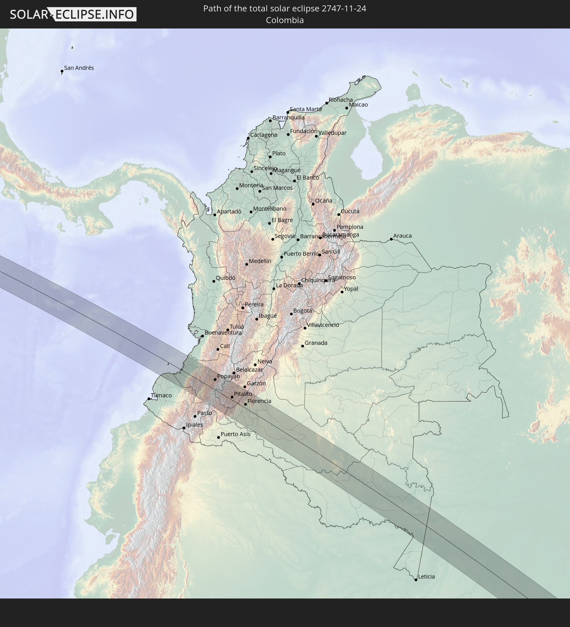
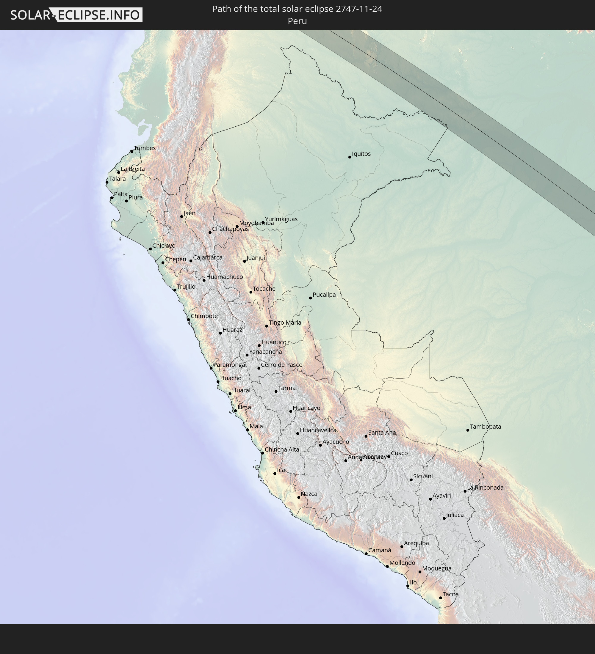
Detaillierte Länderkarten
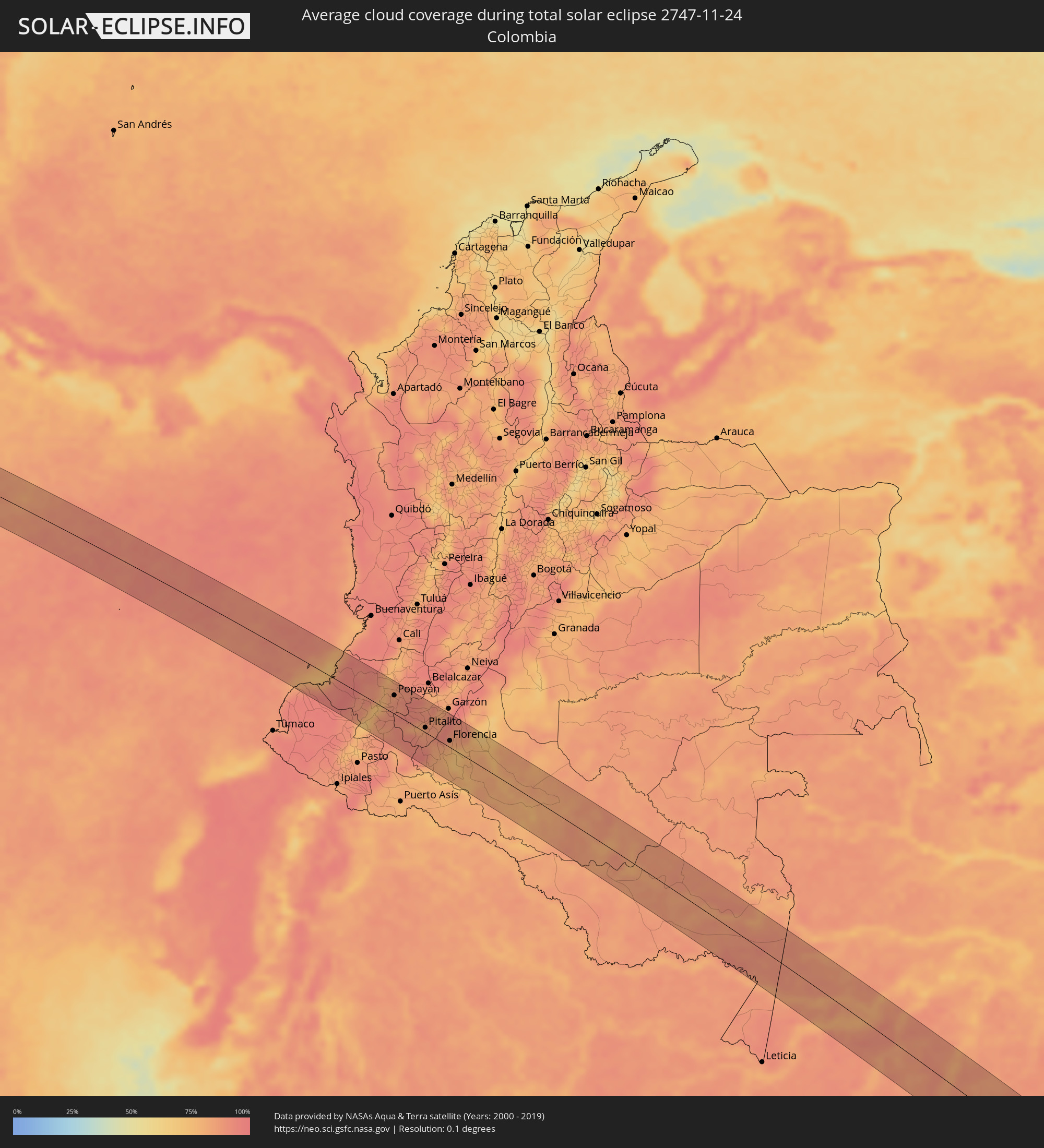 Kolumbien
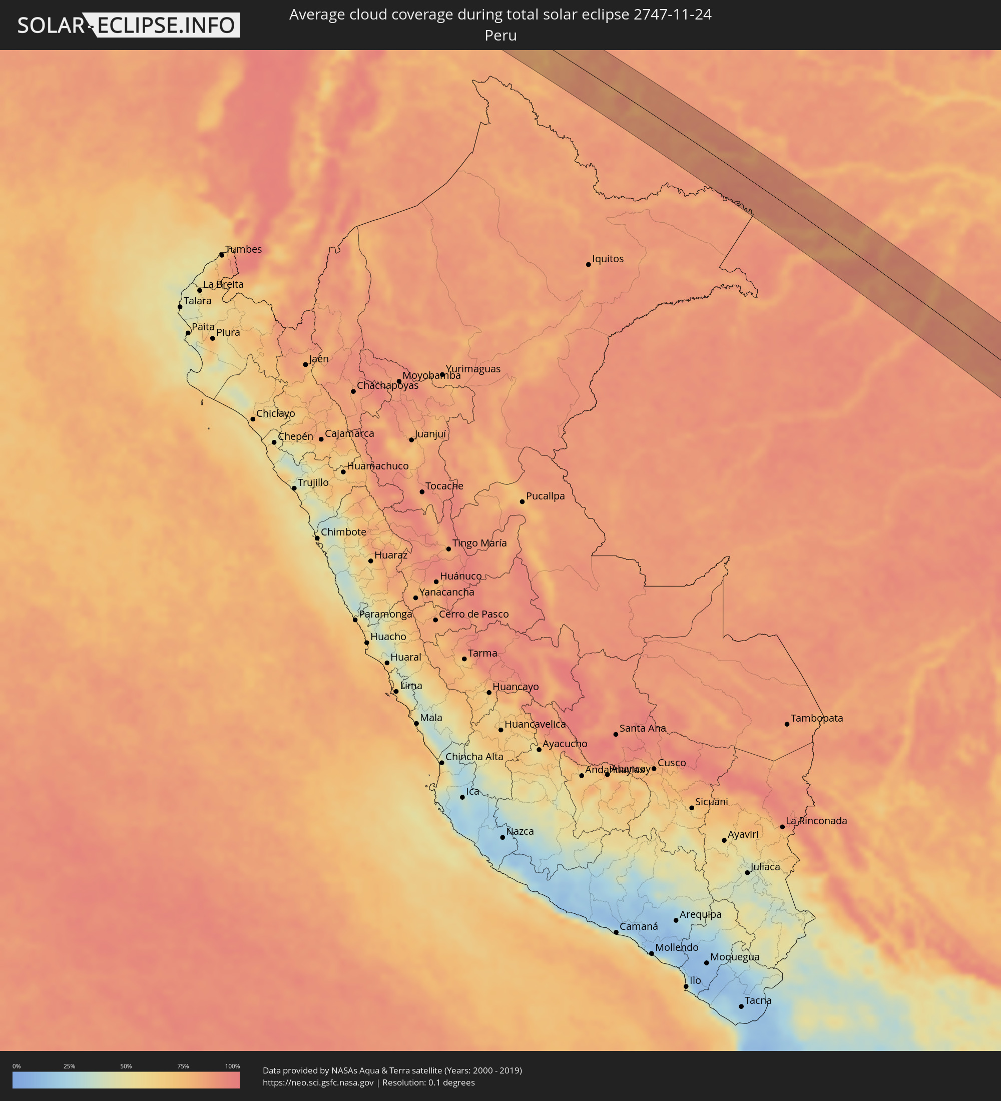 Peru
Peru
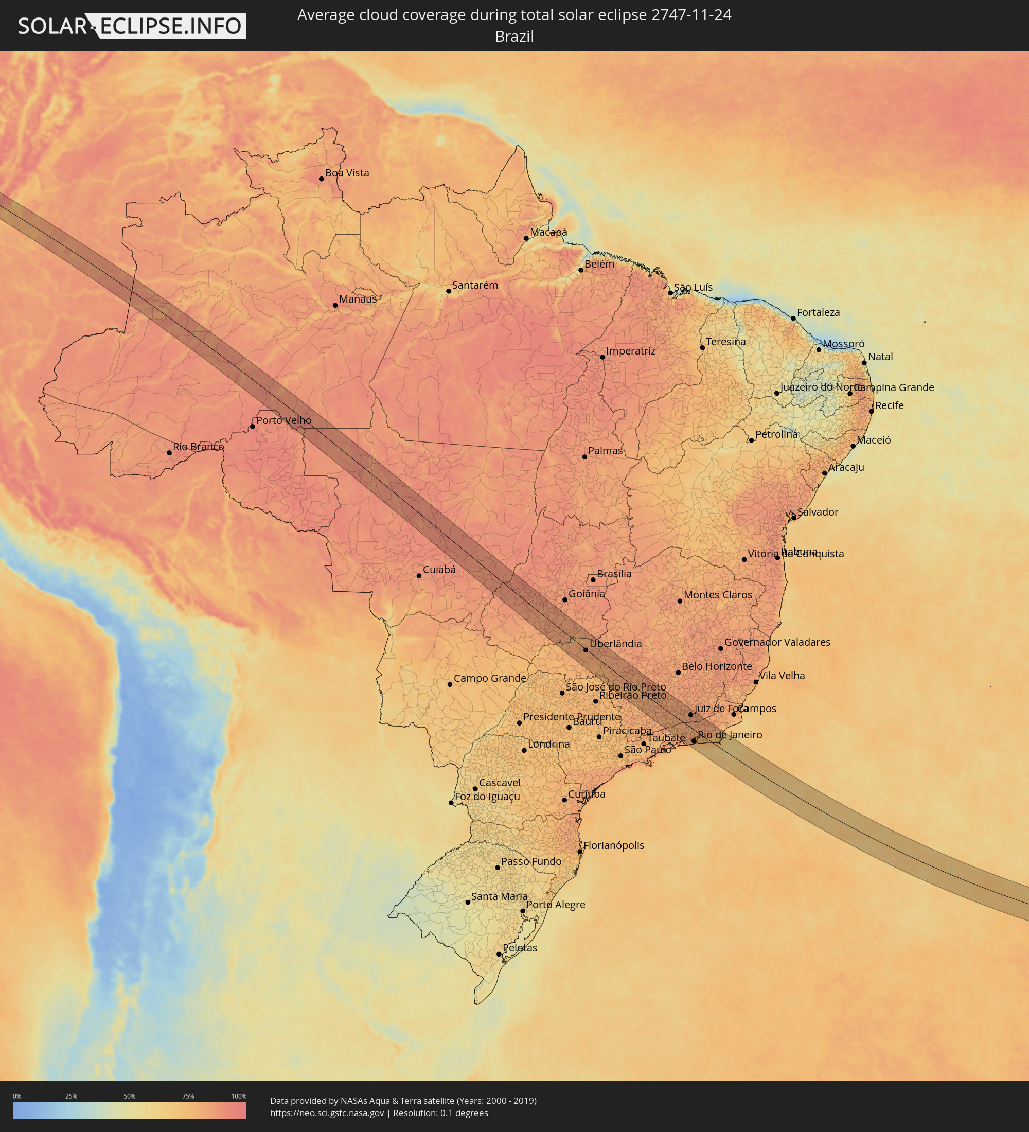 Brasilien
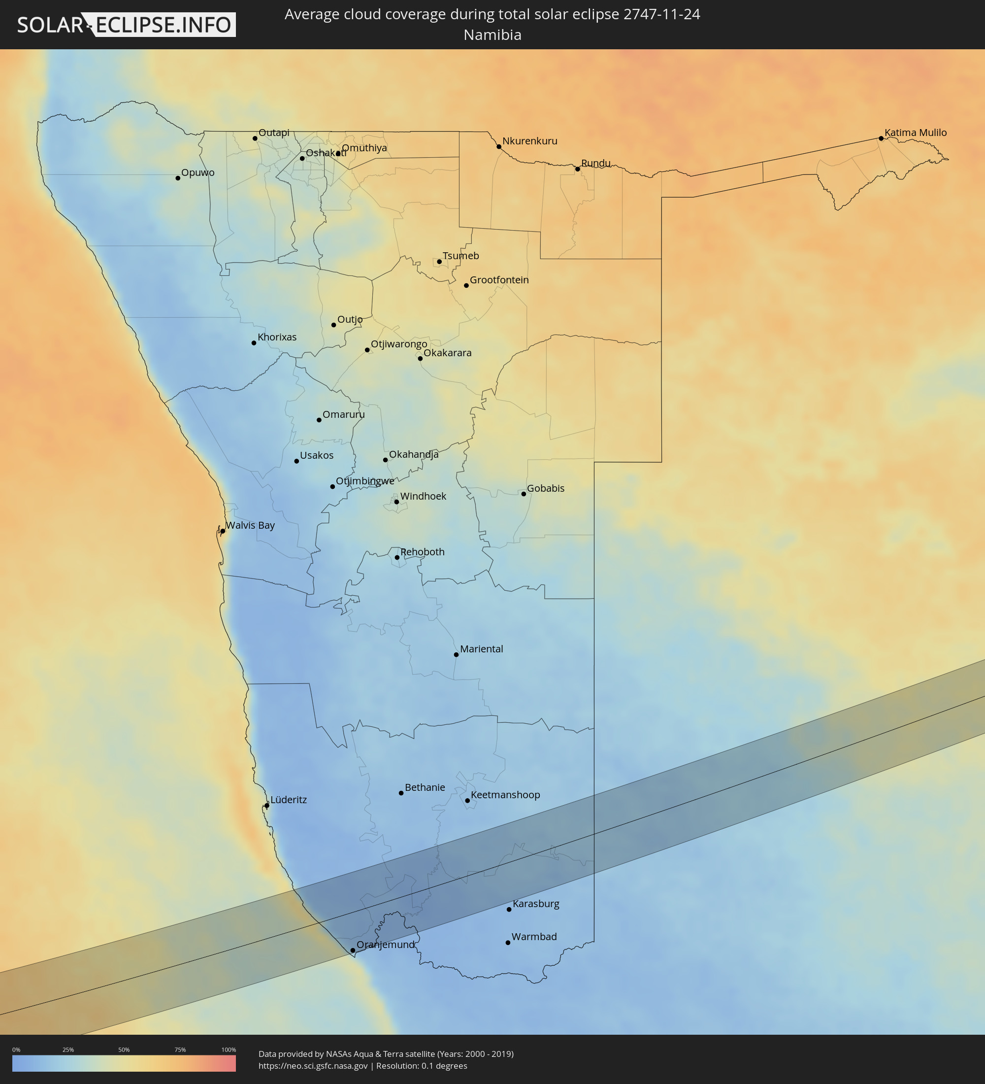 Namibia
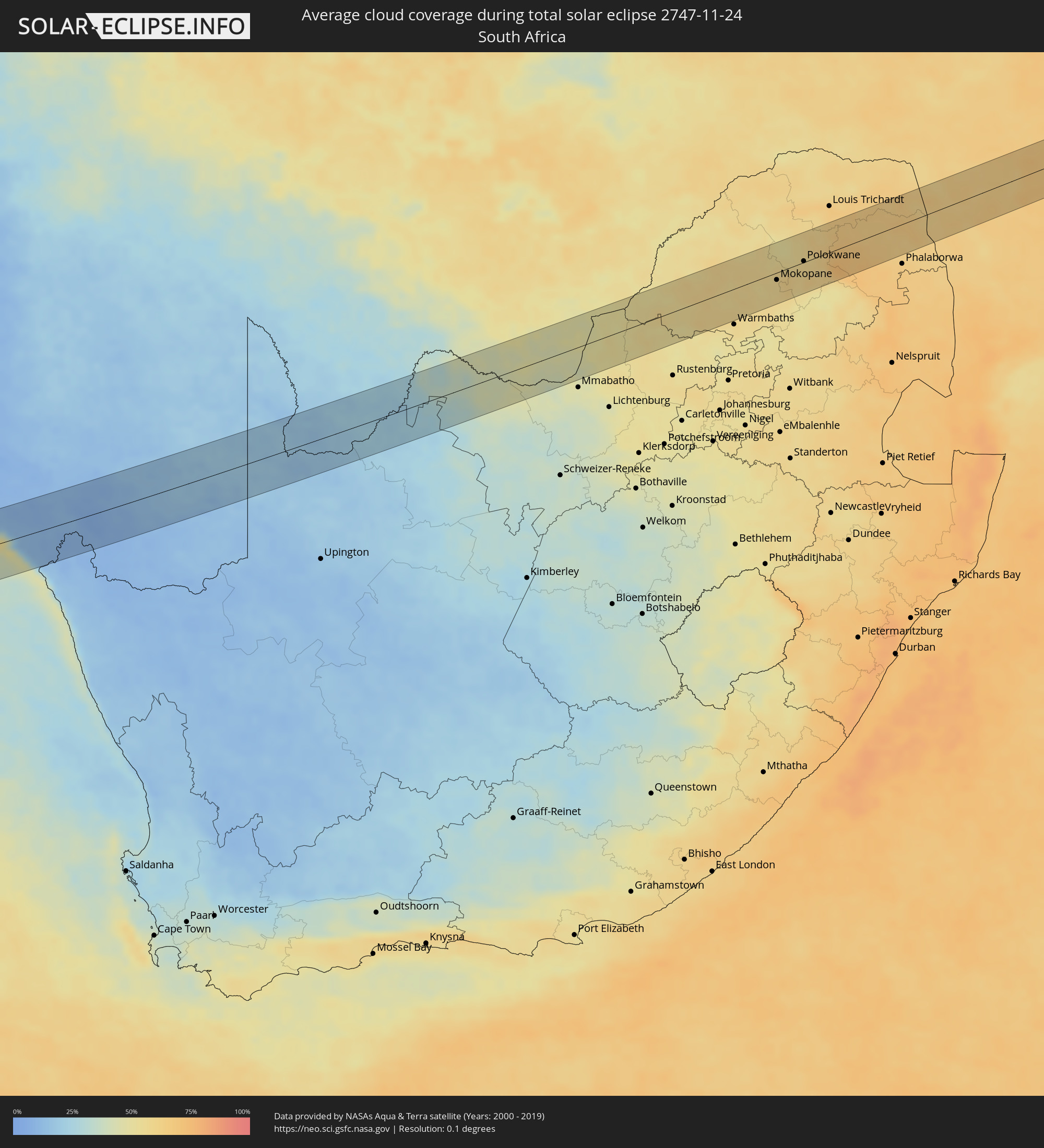 Südafrika
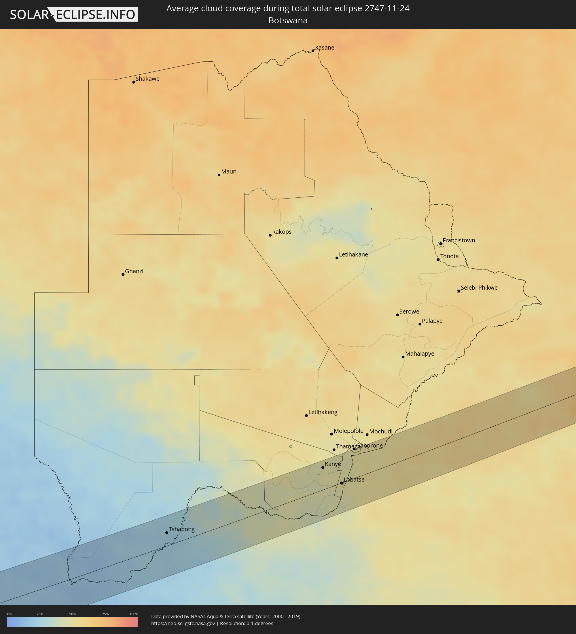 Botswana
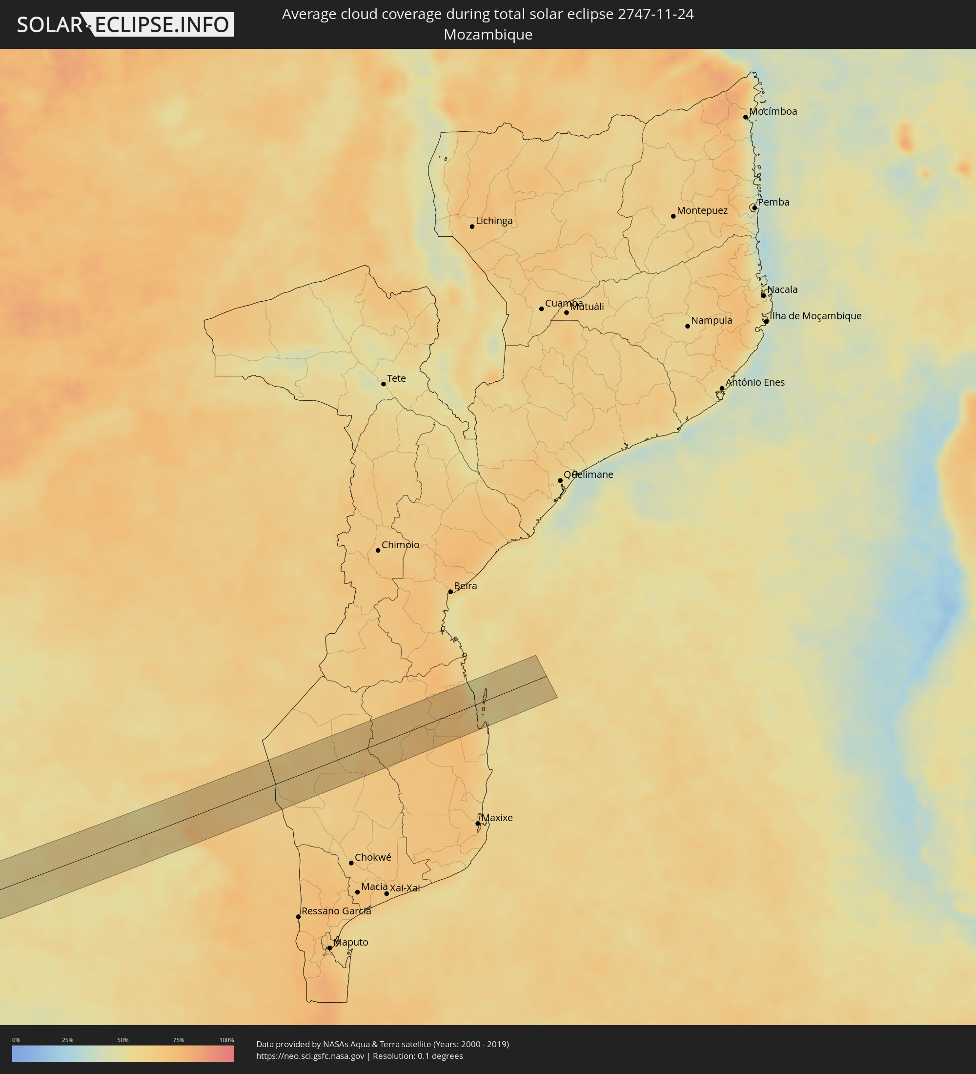 Mosambik
Orte im Finsternispfad
Die nachfolgene Tabelle zeigt Städte und Orte mit mehr als 5.000 Einwohnern, die sich im Finsternispfad befinden. Städte mit mehr als 100.000 Einwohnern sind dick gekennzeichnet. Mit einem Klick auf den Ort öffnet sich eine Detailkarte die die Lage des jeweiligen Ortes zusammen mit dem Verlauf der zentralen Finsternis präsentiert.
| Ort | Typ | Dauer der Verfinsterung | Ortszeit bei maximaler Verfinsterung | Entfernung zur Zentrallinie | Ø Bewölkung |
|
El Charco, Nariño
|
total | - | 07:32:47 UTC-05:00 | 48 km | 94% |
|
Guapi, Cauca
|
total | - | 07:32:47 UTC-05:00 | 27 km | 88% |
|
Timbiquí, Cauca
|
total | - | 07:32:42 UTC-05:00 | 5 km | 88% |
|
Balboa, Cauca
|
total | - | 07:33:32 UTC-05:00 | 40 km | 69% |
|
Patía, Cauca
|
total | - | 07:33:35 UTC-05:00 | 28 km | 75% |
|
El Bordo, Cauca
|
total | - | 07:33:34 UTC-05:00 | 20 km | 77% |
|
Villa Rica, Cauca
|
total | - | 07:33:16 UTC-05:00 | 26 km | 79% |
|
El Tambo, Cauca
|
total | - | 07:33:20 UTC-05:00 | 22 km | 79% |
|
Popayán, Cauca
|
total | - | 07:33:26 UTC-05:00 | 32 km | 88% |
|
San Agustín, Huila
|
total | - | 07:34:06 UTC-05:00 | 2 km | 82% |
|
Isnos, Huila
|
total | - | 07:34:03 UTC-05:00 | 5 km | 80% |
|
Pitalito, Huila
|
total | - | 07:34:13 UTC-05:00 | 9 km | 82% |
|
Timaná, Huila
|
total | - | 07:34:10 UTC-05:00 | 27 km | 87% |
|
Florencia, Caquetá
|
total | - | 07:34:39 UTC-05:00 | 11 km | 80% |
|
El Paujil, Caquetá
|
total | - | 07:34:49 UTC-05:00 | 23 km | 79% |
|
El Doncello, Caquetá
|
total | - | 07:34:45 UTC-05:00 | 36 km | 86% |
|
Cartagena del Chairá, Caquetá
|
total | - | 07:35:17 UTC-05:00 | 29 km | 74% |
|
Barra do Garças, Mato Grosso
|
total | - | 09:23:07 UTC-04:00 | 7 km | 86% |
|
Santa Helena de Goiás, Goiás
|
total | - | 10:29:18 UTC-03:00 | 61 km | 81% |
|
Itumbiara, Goiás
|
total | - | 10:32:51 UTC-03:00 | 22 km | 79% |
|
Morrinhos, Goiás
|
total | - | 10:31:52 UTC-03:00 | 46 km | 85% |
|
Uberlândia, Minas Gerais
|
total | - | 10:35:28 UTC-03:00 | 4 km | 80% |
|
Araguari, Minas Gerais
|
total | - | 10:35:10 UTC-03:00 | 26 km | 79% |
|
Uberaba, Minas Gerais
|
total | - | 10:37:34 UTC-03:00 | 54 km | 78% |
|
Monte Carmelo, Minas Gerais
|
total | - | 10:36:38 UTC-03:00 | 64 km | 85% |
|
Araxá, Minas Gerais
|
total | - | 10:39:13 UTC-03:00 | 23 km | 80% |
|
Passos, Minas Gerais
|
total | - | 10:41:48 UTC-03:00 | 56 km | 78% |
|
Boa Esperança, Minas Gerais
|
total | - | 10:44:31 UTC-03:00 | 24 km | 81% |
|
Arcos, Minas Gerais
|
total | - | 10:43:12 UTC-03:00 | 50 km | 86% |
|
Três Pontas, Minas Gerais
|
total | - | 10:45:06 UTC-03:00 | 45 km | 82% |
|
Varginha, Minas Gerais
|
total | - | 10:45:35 UTC-03:00 | 56 km | 81% |
|
Formiga, Minas Gerais
|
total | - | 10:43:44 UTC-03:00 | 41 km | 82% |
|
Campo Belo, Minas Gerais
|
total | - | 10:44:47 UTC-03:00 | 12 km | 82% |
|
Três Corações, Minas Gerais
|
total | - | 10:46:11 UTC-03:00 | 59 km | 80% |
|
Lavras, Minas Gerais
|
total | - | 10:45:56 UTC-03:00 | 3 km | 80% |
|
Oliveira, Minas Gerais
|
total | - | 10:45:21 UTC-03:00 | 57 km | 83% |
|
São João del Rei, Minas Gerais
|
total | - | 10:47:16 UTC-03:00 | 52 km | 81% |
|
Volta Redonda, Rio de Janeiro
|
total | - | 10:49:56 UTC-03:00 | 64 km | 80% |
|
Barra do Piraí, Rio de Janeiro
|
total | - | 10:50:25 UTC-03:00 | 42 km | 80% |
|
Valença, Rio de Janeiro
|
total | - | 10:50:19 UTC-03:00 | 14 km | 83% |
|
Japeri, Rio de Janeiro
|
total | - | 10:51:04 UTC-03:00 | 48 km | 81% |
|
Santos Dumont, Minas Gerais
|
total | - | 10:49:18 UTC-03:00 | 66 km | 82% |
|
Nova Iguaçu, Rio de Janeiro
|
total | - | 10:51:41 UTC-03:00 | 46 km | 82% |
|
Juiz de Fora, Minas Gerais
|
total | - | 10:50:15 UTC-03:00 | 50 km | 85% |
|
Três Rios, Rio de Janeiro
|
total | - | 10:51:08 UTC-03:00 | 27 km | 80% |
|
Rio de Janeiro, Rio de Janeiro
|
total | - | 10:52:26 UTC-03:00 | 45 km | 76% |
|
Petrópolis, Rio de Janeiro
|
total | - | 10:51:50 UTC-03:00 | 7 km | 82% |
|
Teresópolis, Rio de Janeiro
|
total | - | 10:52:07 UTC-03:00 | 13 km | 84% |
|
Itaboraí, Rio de Janeiro
|
total | - | 10:52:55 UTC-03:00 | 10 km | 78% |
|
Maricá, Rio de Janeiro
|
total | - | 10:53:17 UTC-03:00 | 24 km | 74% |
|
Cachoeiras de Macacu, Rio de Janeiro
|
total | - | 10:52:53 UTC-03:00 | 28 km | 78% |
|
Rio Bonito, Rio de Janeiro
|
total | - | 10:53:23 UTC-03:00 | 8 km | 78% |
|
Nova Friburgo, Rio de Janeiro
|
total | - | 10:52:51 UTC-03:00 | 51 km | 83% |
|
Saquarema, Rio de Janeiro
|
total | - | 10:53:57 UTC-03:00 | 6 km | 75% |
|
Araruama, Rio de Janeiro
|
total | - | 10:54:14 UTC-03:00 | 8 km | 77% |
|
Cabo Frio, Rio de Janeiro
|
total | - | 10:54:56 UTC-03:00 | 25 km | 73% |
|
Rio das Ostras, Rio de Janeiro
|
total | - | 10:54:32 UTC-03:00 | 63 km | 71% |
|
Oranjemund, Karas
|
total | - | 17:45:16 UTC+02:00 | 54 km | 43% |
|
Tshabong, Kgalagadi
|
total | - | 17:49:15 UTC+02:00 | 22 km | 21% |
|
Kanye, Ngwaketsi
|
total | - | 17:50:35 UTC+02:00 | 38 km | 47% |
|
Janeng, South-East
|
total | - | 17:50:23 UTC+02:00 | 16 km | 45% |
|
Lobatse, South-East
|
total | - | 17:50:31 UTC+02:00 | 1 km | 47% |
|
Otse, South-East
|
total | - | 17:50:38 UTC+02:00 | 19 km | 47% |
|
Ramotswa, South-East
|
total | - | 17:50:44 UTC+02:00 | 30 km | 48% |
|
Gaborone, South-East
|
total | - | 17:50:51 UTC+02:00 | 51 km | 49% |
|
Zeerust, North-West
|
total | - | 17:50:25 UTC+02:00 | 47 km | 51% |
|
Thabazimbi, Limpopo
|
total | - | 17:51:07 UTC+02:00 | 4 km | 55% |
|
Modimolle, Limpopo
|
total | - | 17:51:11 UTC+02:00 | 42 km | 57% |
|
Mokopane, Limpopo
|
total | - | 17:51:30 UTC+02:00 | 12 km | 56% |
|
Polokwane, Limpopo
|
total | - | 17:51:40 UTC+02:00 | 2 km | 57% |
|
Lebowakgomo, Limpopo
|
total | - | 17:51:32 UTC+02:00 | 30 km | 60% |
|
Mankoeng, Limpopo
|
total | - | 17:51:42 UTC+02:00 | 11 km | 59% |
|
Duiwelskloof, Limpopo
|
total | - | 17:51:49 UTC+02:00 | 1 km | 70% |
|
Tzaneen, Limpopo
|
total | - | 17:51:45 UTC+02:00 | 16 km | 69% |
|
Ga-Kgapane, Limpopo
|
total | - | 17:51:50 UTC+02:00 | 1 km | 68% |
|
Nkowakowa, Limpopo
|
total | - | 17:51:43 UTC+02:00 | 27 km | 69% |
|
Giyani, Limpopo
|
total | - | 17:52:01 UTC+02:00 | 18 km | 64% |