Totale Sonnenfinsternis vom 25.12.2755
| Wochentag: | Sonntag |
| Maximale Dauer der Verfinsterung: | 03m05s |
| Maximale Breite des Finsternispfades: | 174 km |
| Saroszyklus: | 173 |
| Bedeckungsgrad: | 100% |
| Magnitude: | 1.0335 |
| Gamma: | 0.7595 |
Wo kann man die Sonnenfinsternis vom 25.12.2755 sehen?
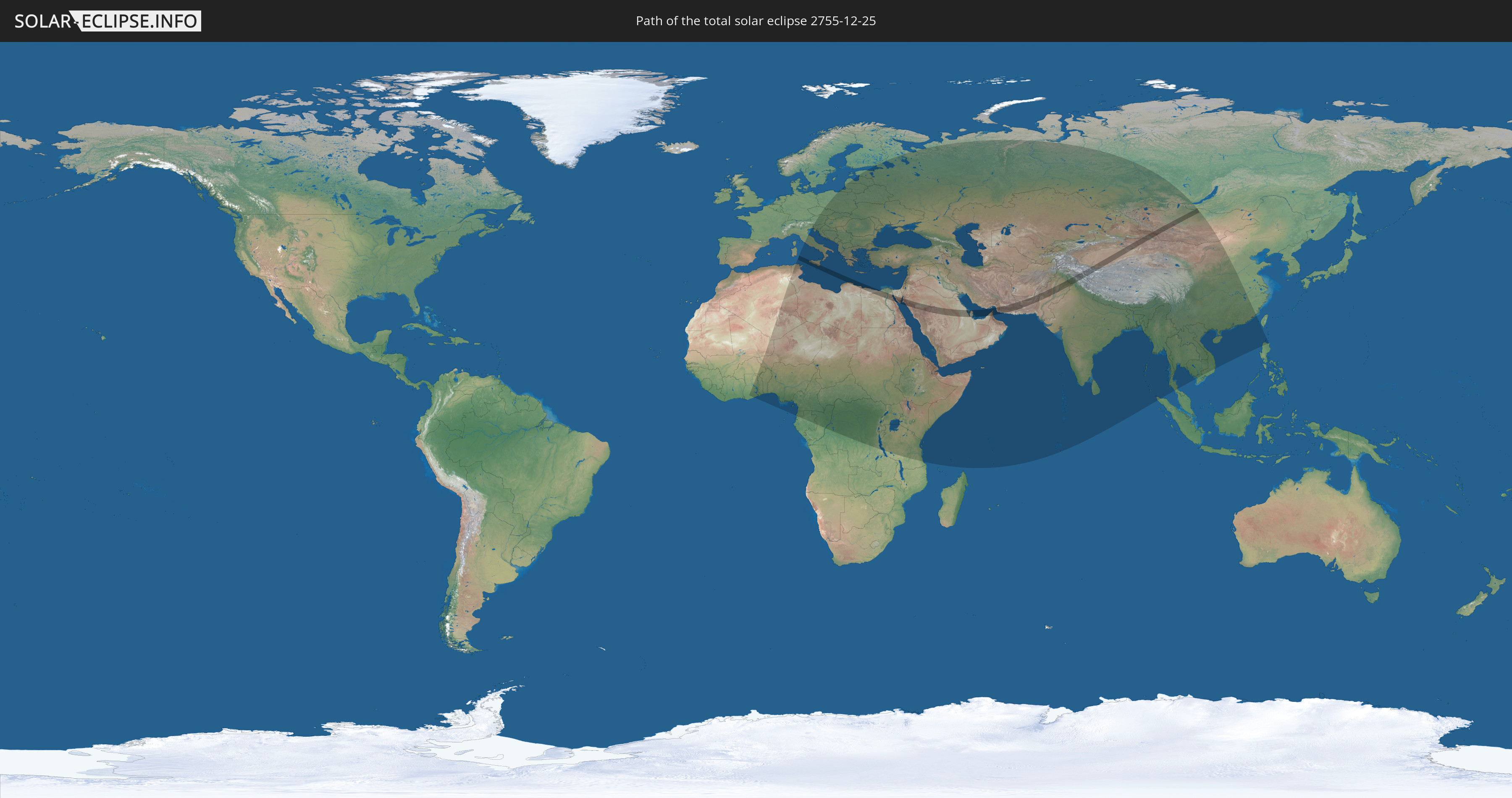
Die Sonnenfinsternis am 25.12.2755 kann man in 101 Ländern als partielle Sonnenfinsternis beobachten.
Der Finsternispfad verläuft durch 13 Länder. Nur in diesen Ländern ist sie als totale Sonnenfinsternis zu sehen.
In den folgenden Ländern ist die Sonnenfinsternis total zu sehen
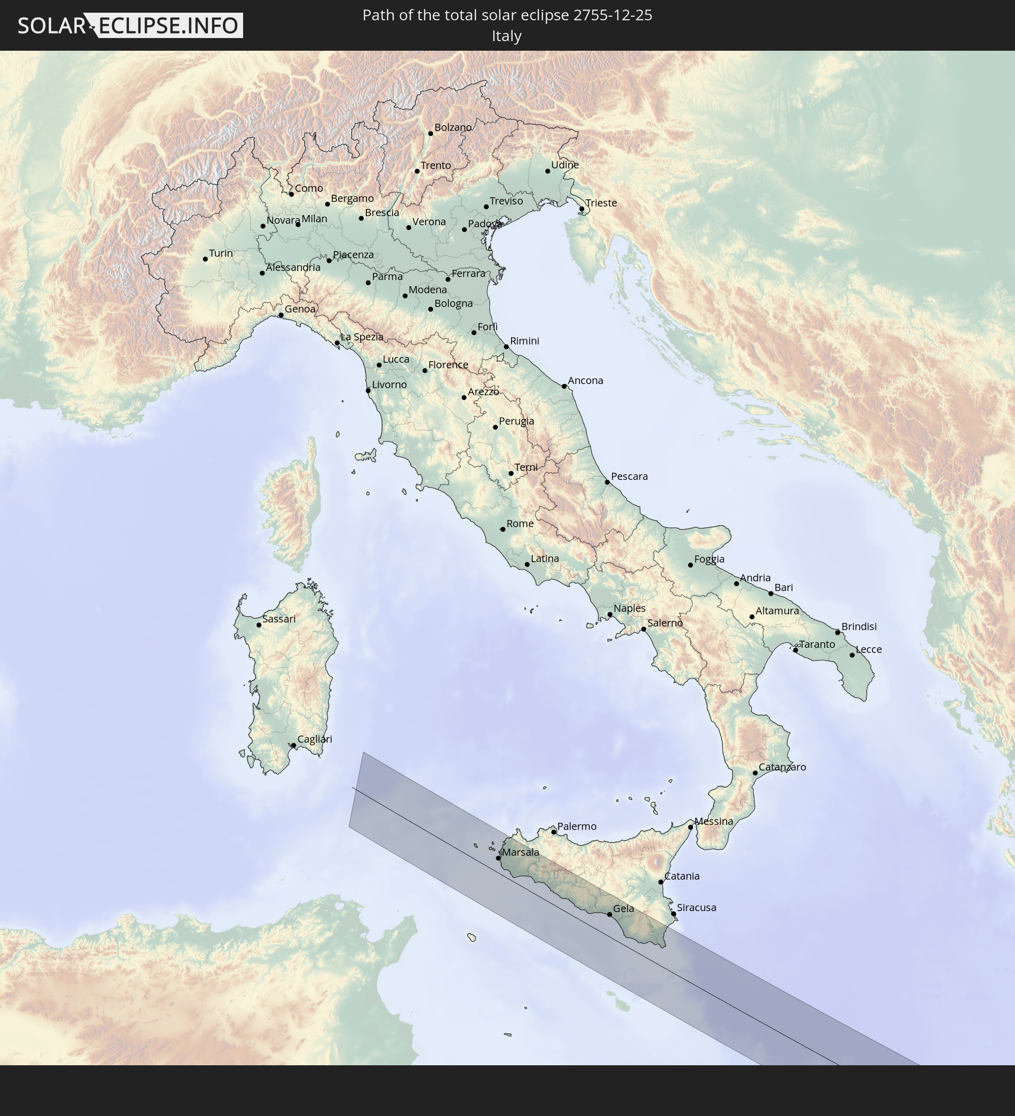 Italien
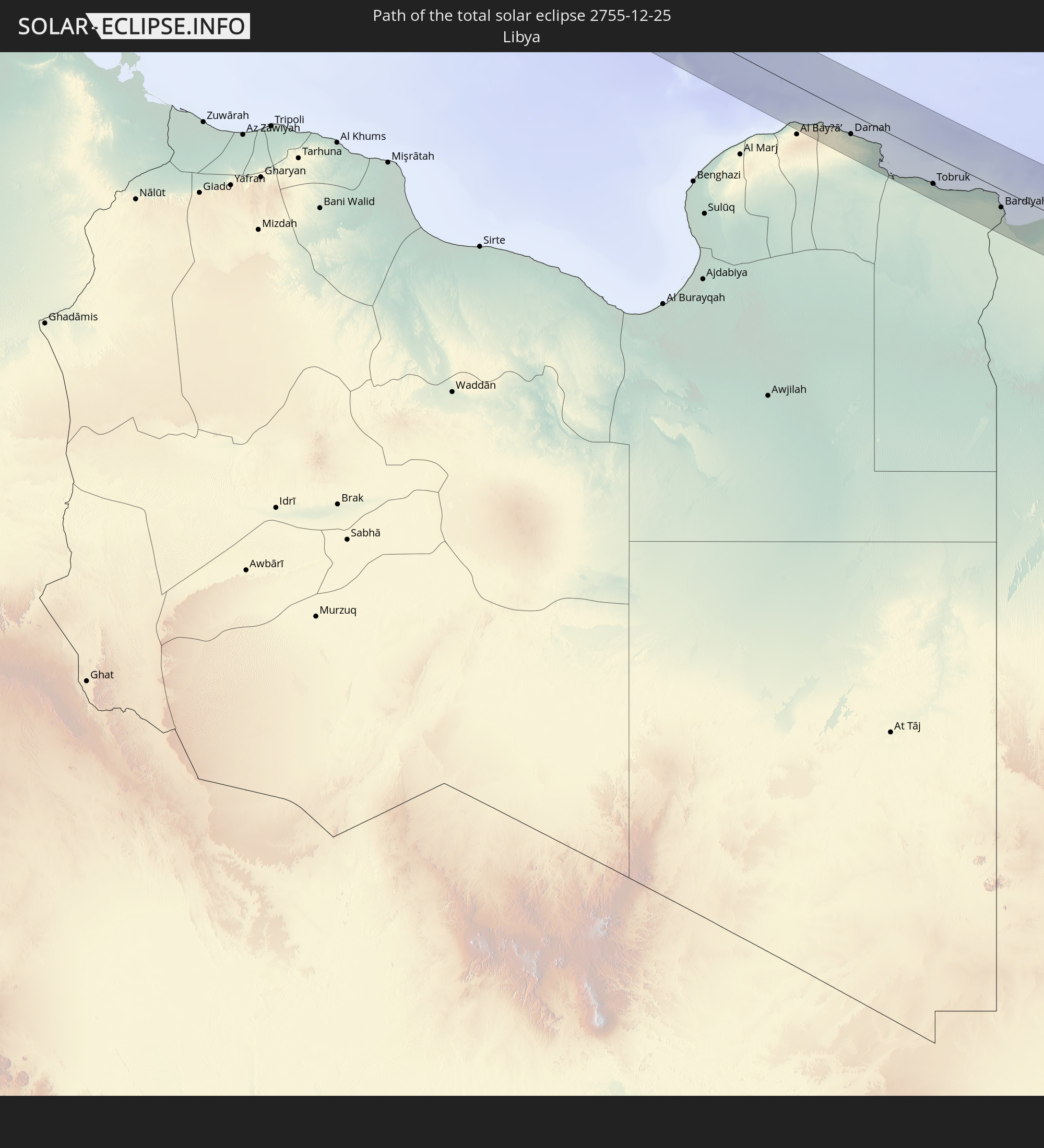 Libyen
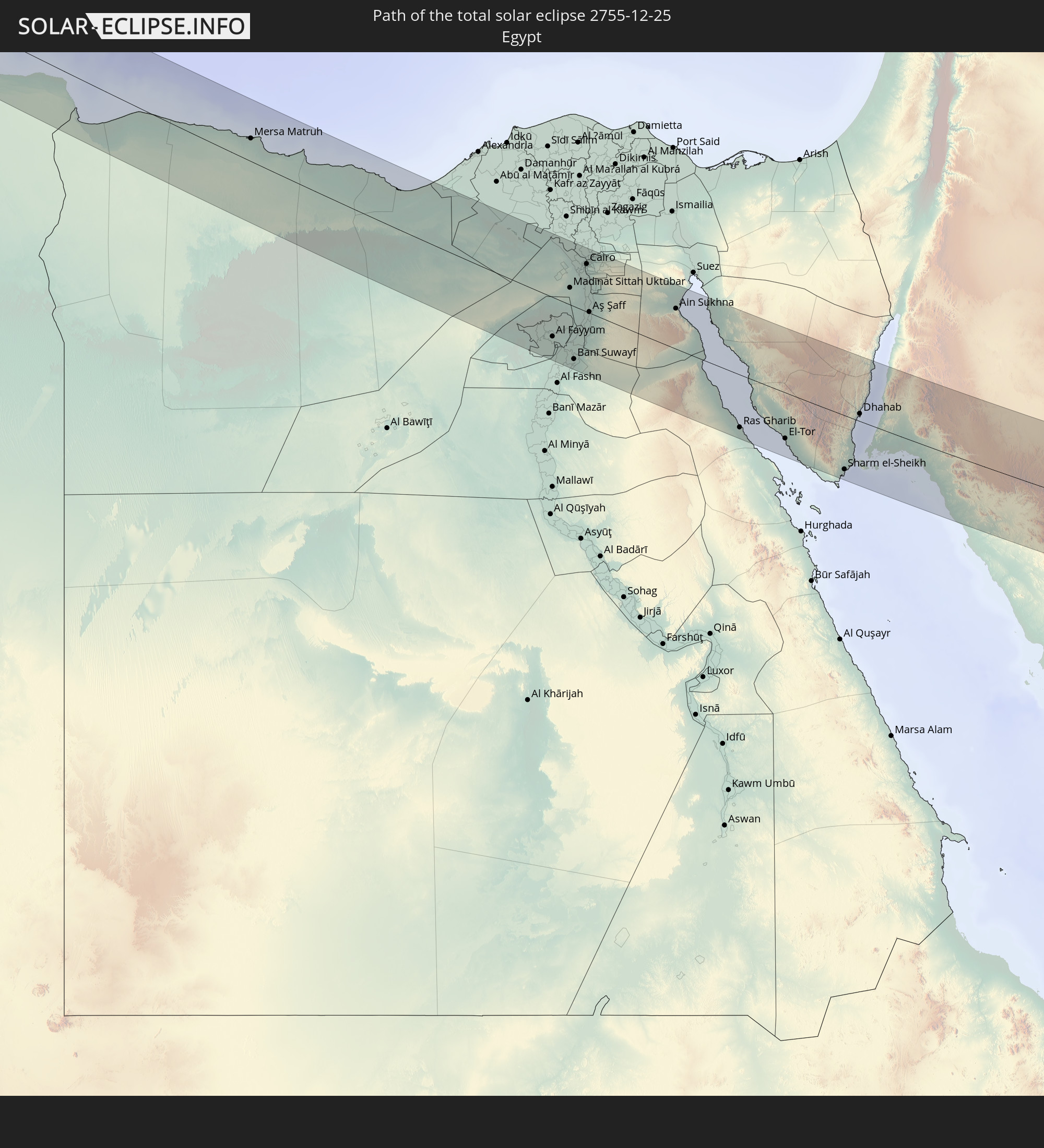 Ägypten
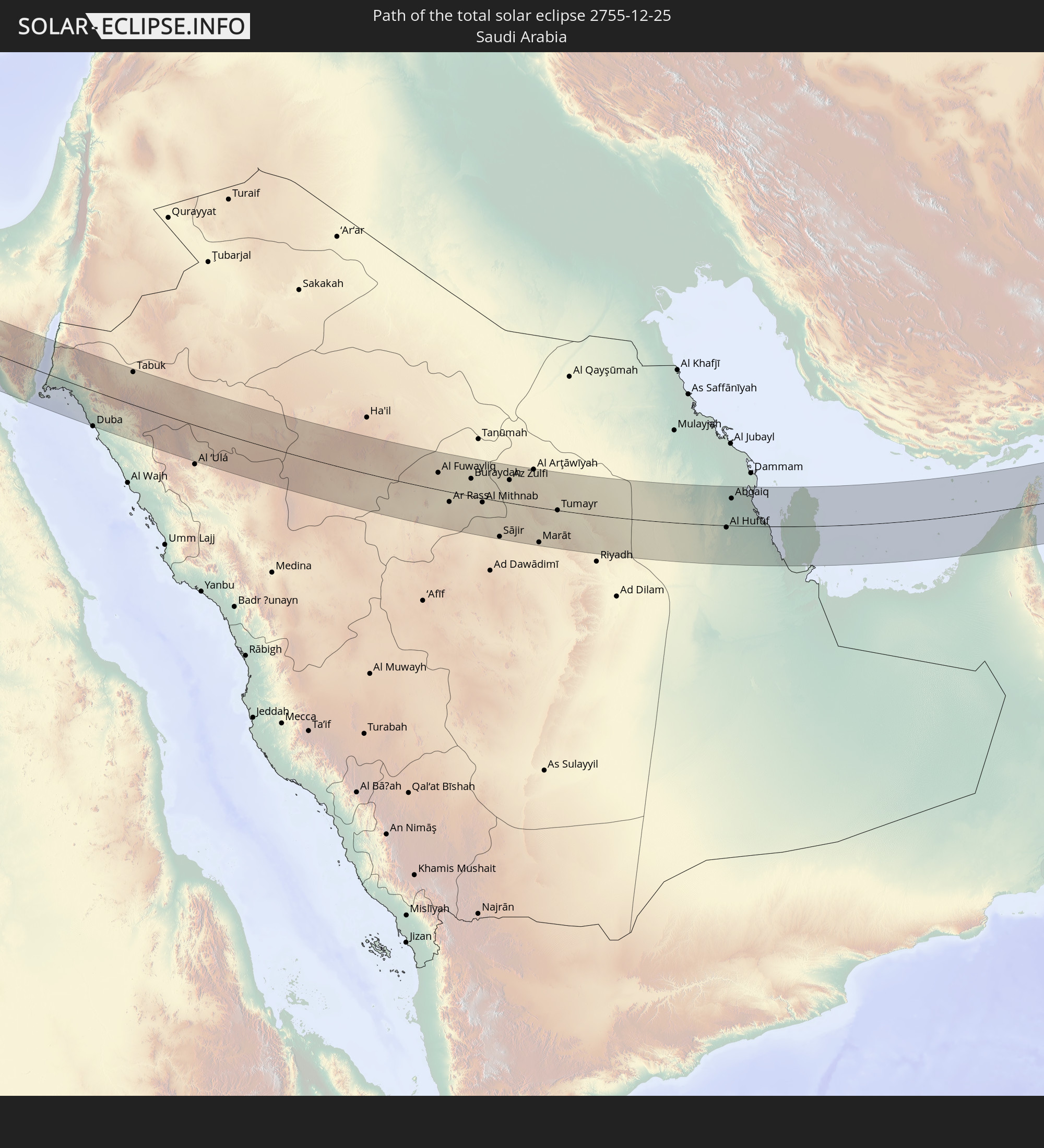 Saudi-Arabien
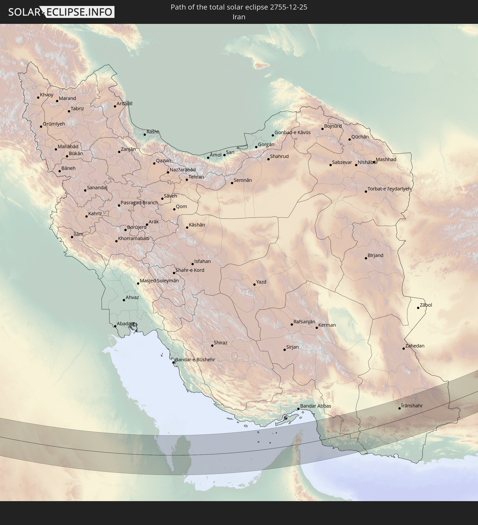 Iran
Iran
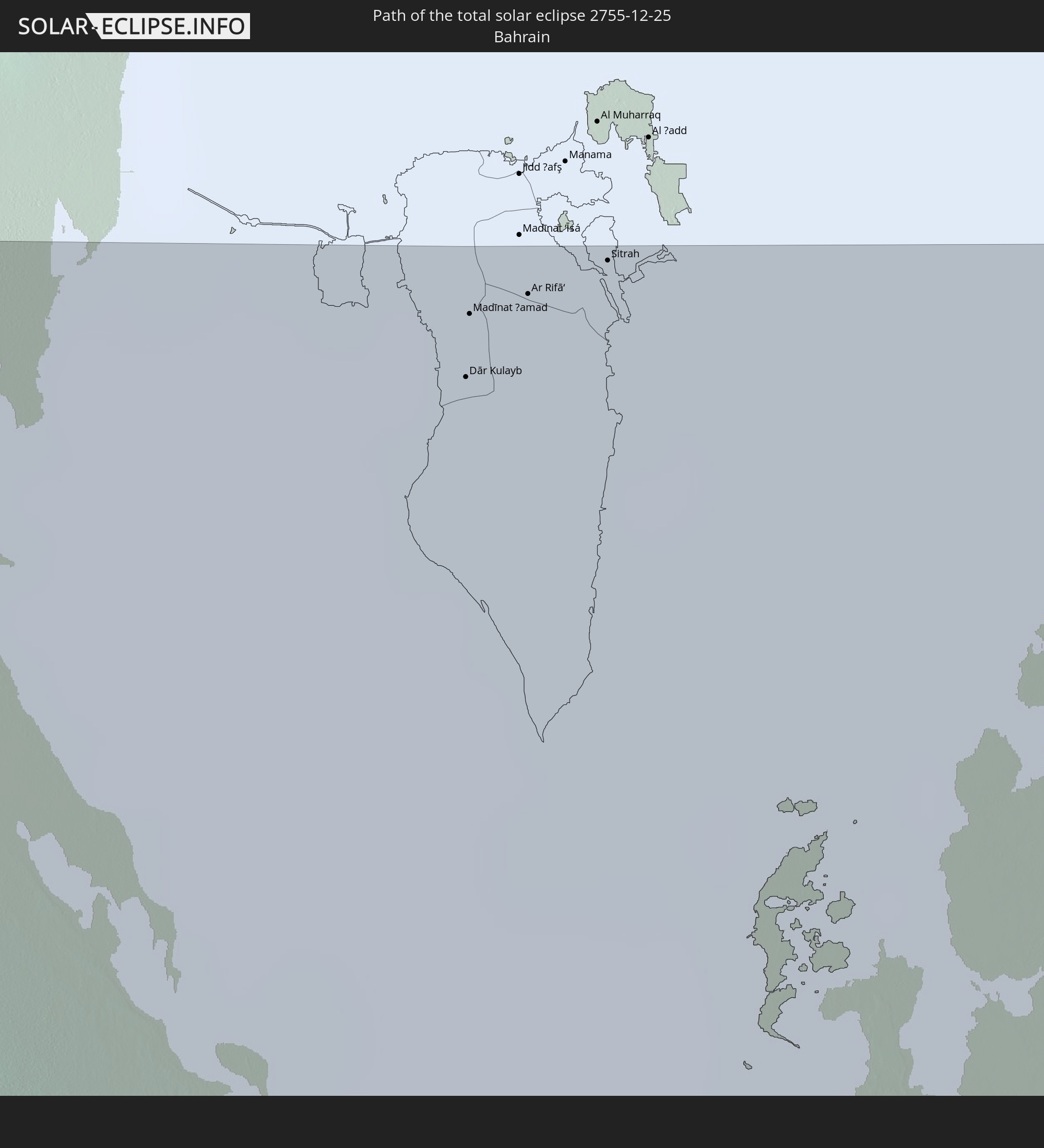 Bahrain
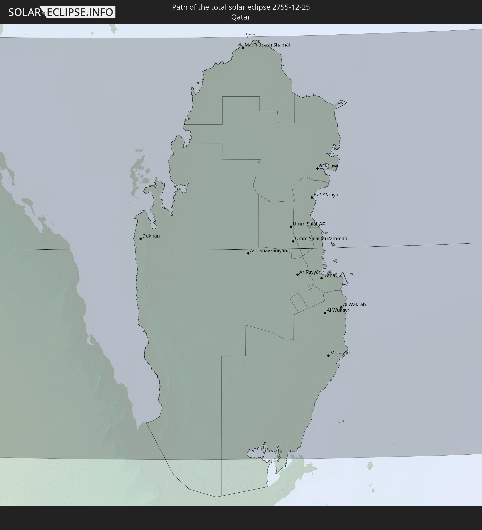 Katar
Katar
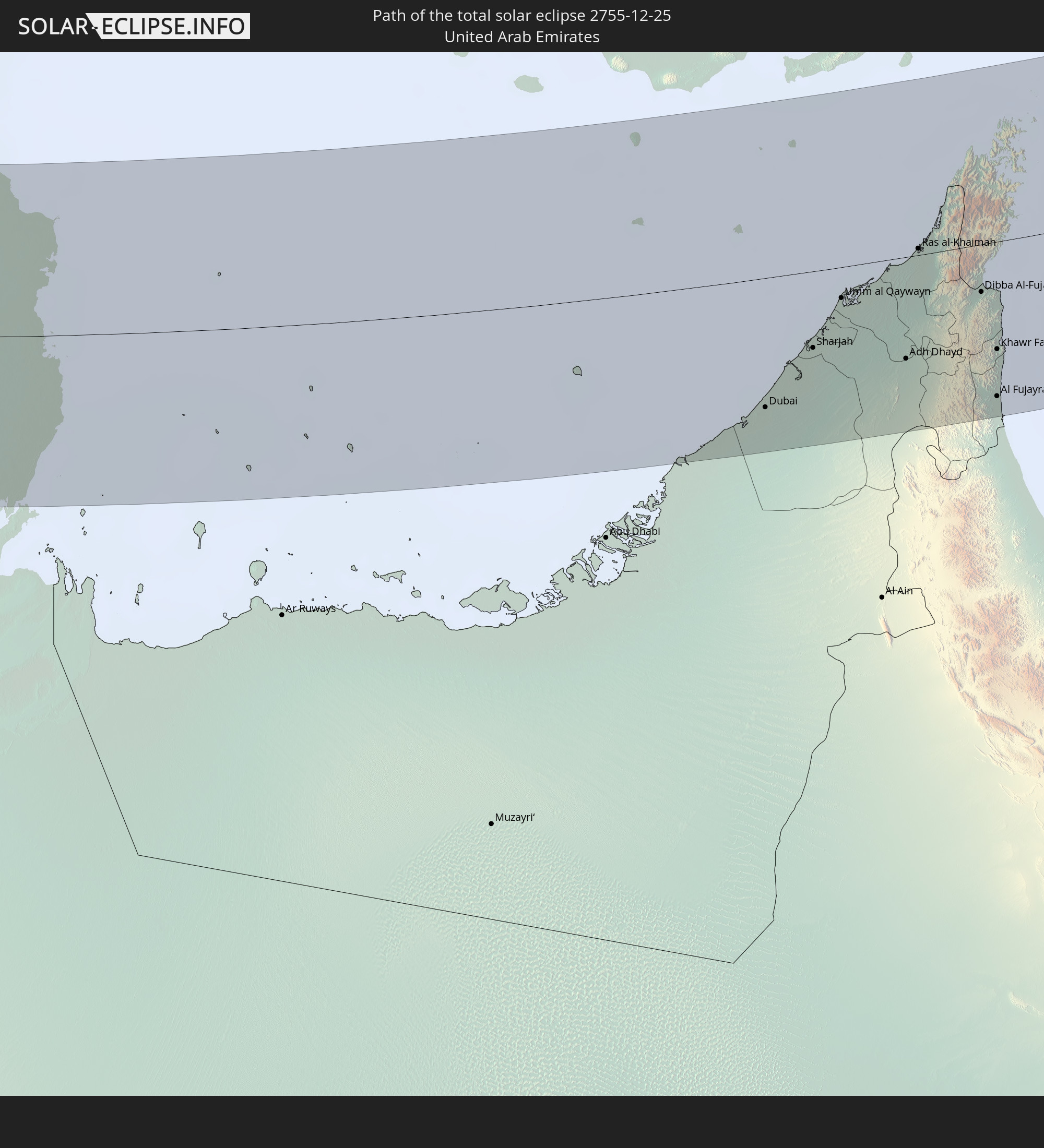 Vereinigte Arabische Emirate
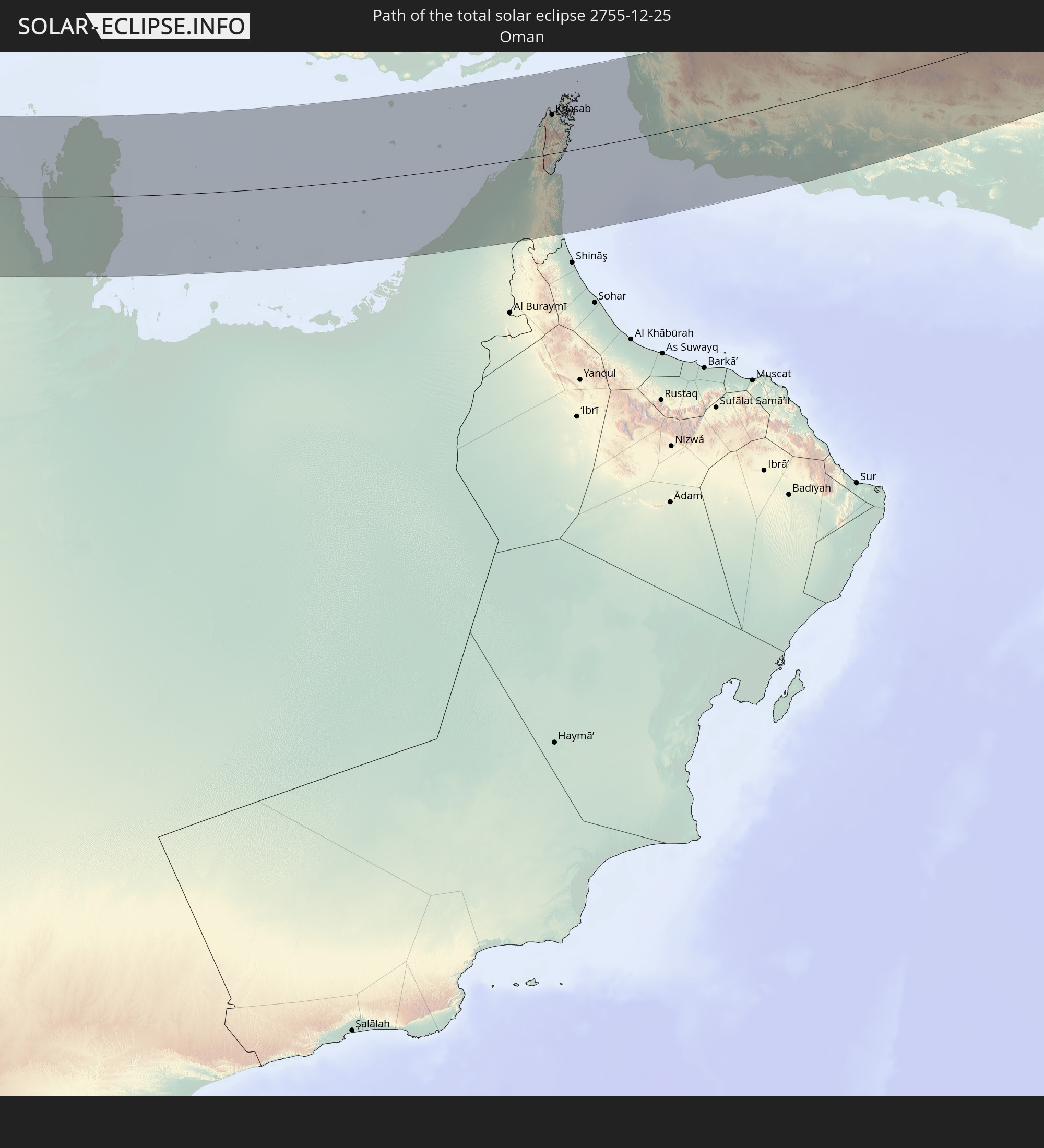 Oman
Oman
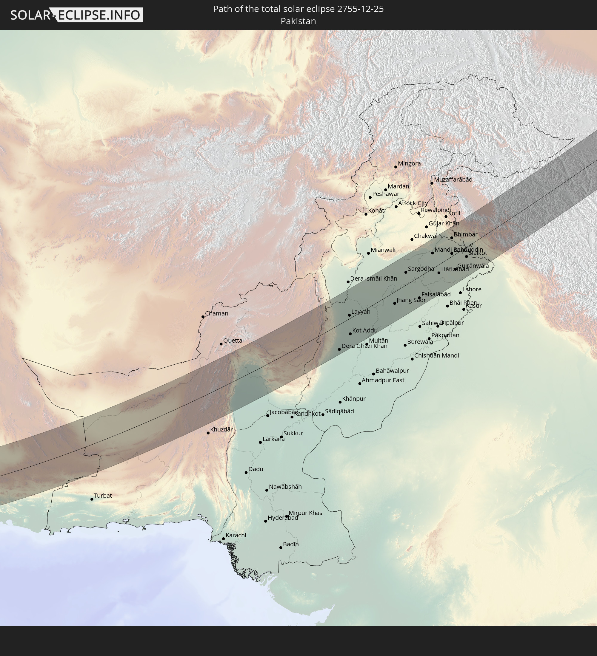 Pakistan
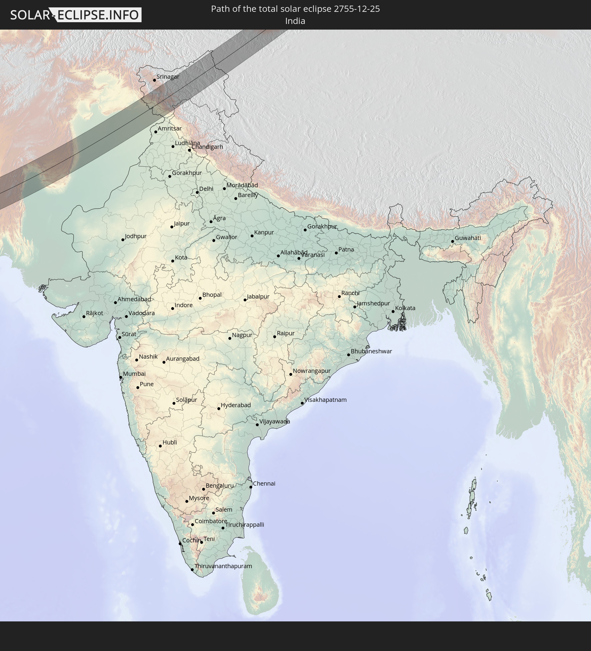 Indien
 Volksrepublik China
 Mongolei
In den folgenden Ländern ist die Sonnenfinsternis partiell zu sehen
 Russland
 Mali
Mali
 Algerien
 Burkina Faso
 Ghana
Ghana
 Togo
Togo
 Niger
Niger
 Benin
Benin
 Nigeria
 Äquatorialguinea
 Italien
 Tunesien
 Kamerun
 Gabun
Gabun
 Libyen
 Österreich
 Republik Kongo
 Tschechien
 Demokratische Republik Kongo
 San Marino
 Vatikanstadt
 Slowenien
 Tschad
 Kroatien
 Polen
Polen
 Malta
Malta
 Zentralafrikanische Republik
 Bosnien und Herzegowina
 Ungarn
 Slowakei
 Montenegro
 Serbien
 Albanien
 Griechenland
 Rumänien
 Mazedonien
 Litauen
 Lettland
 Estland
 Sudan
Sudan
 Ukraine
 Bulgarien
 Weißrussland
 Ägypten
 Türkei
 Moldawien
 Ruanda
 Burundi
 Tansania
 Uganda
 Republik Zypern
 Äthiopien
 Kenia
Kenia
 Staat Palästina
 Israel
 Saudi-Arabien
 Jordanien
 Libanon
 Syrien
 Eritrea
 Irak
Irak
 Georgien
 Somalia
 Dschibuti
 Jemen
Jemen
 Armenien
 Iran
Iran
 Aserbaidschan
 Seychellen
 Kasachstan
 Kuwait
 Bahrain
 Katar
Katar
 Vereinigte Arabische Emirate
 Oman
Oman
 Turkmenistan
 Usbekistan
 Mauritius
 Afghanistan
 Pakistan
 Tadschikistan
 Indien
 Kirgisistan
 Britisches Territorium im Indischen Ozean
 Malediven
 Volksrepublik China
 Sri Lanka
 Nepal
Nepal
 Mongolei
 Bangladesch
 Bhutan
 Myanmar
 Indonesien
 Thailand
 Laos
Laos
 Vietnam
 Kambodscha
 Macau
Macau
 Hongkong
 Taiwan
 Philippinen
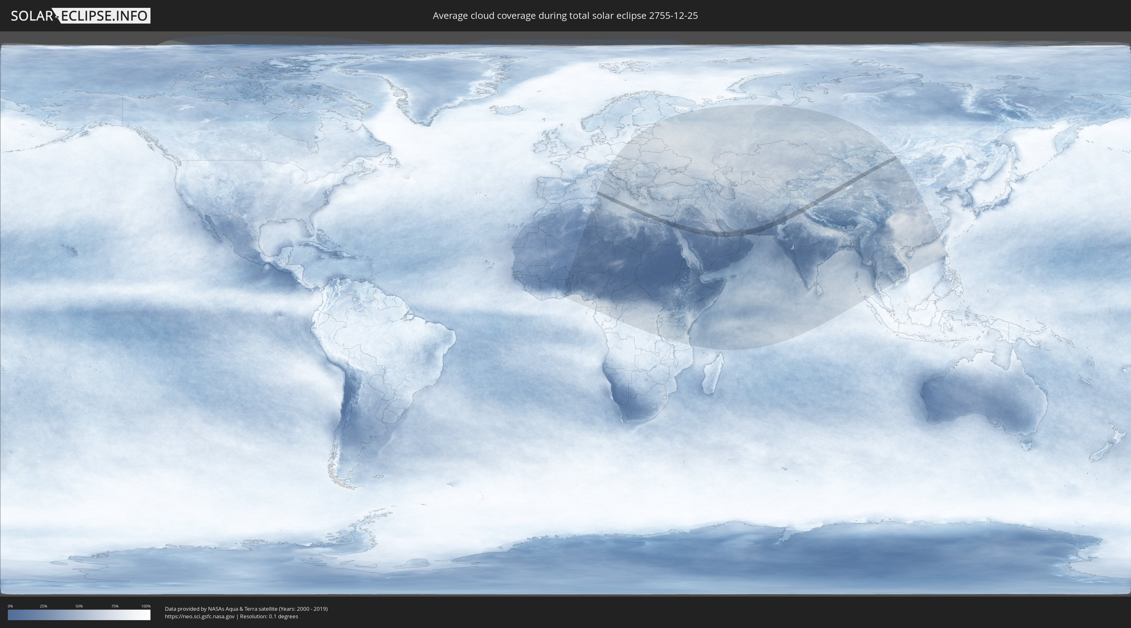
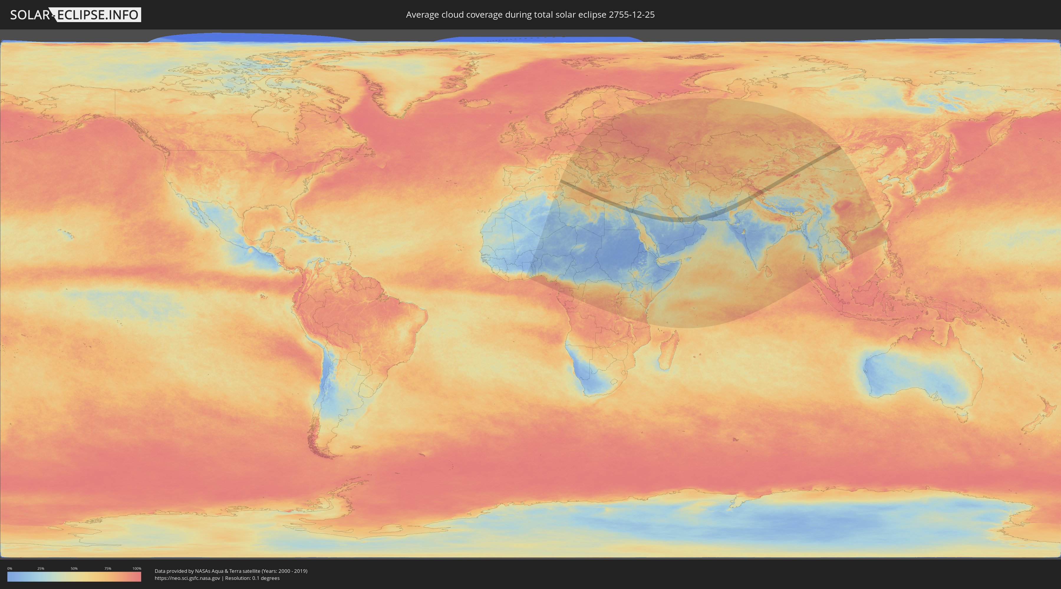
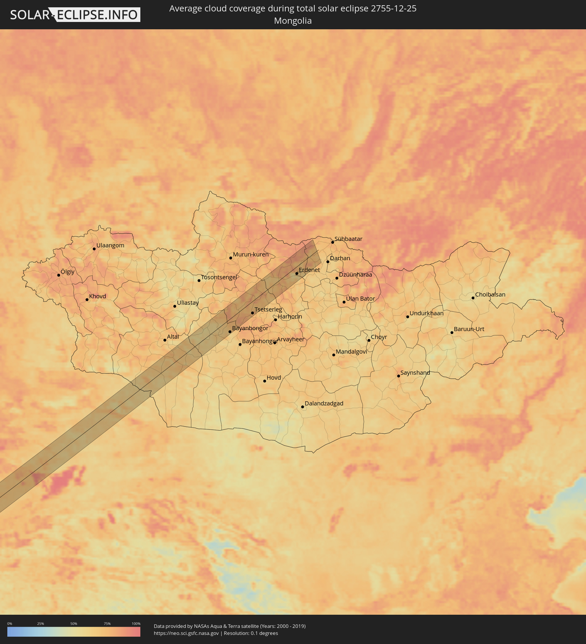
Wie wird das Wetter während der totalen Sonnenfinsternis am 25.12.2755?
Wo ist der beste Ort, um die totale Sonnenfinsternis vom 25.12.2755 zu beobachten?
Die folgenden Karten zeigen die durchschnittliche Bewölkung für den Tag, an dem die totale Sonnenfinsternis
stattfindet. Mit Hilfe der Karten lässt sich der Ort entlang des Finsternispfades eingrenzen,
der die besten Aussichen auf einen klaren wolkenfreien Himmel bietet.
Trotzdem muss man immer lokale Gegenenheiten beachten und sollte sich genau über das Wetter an seinem
gewählten Beobachtungsort informieren.
Die Daten stammen von den beiden NASA-Satelliten
AQUA und TERRA
und wurden über einen Zeitraum von 19 Jahren (2000 - 2019) gemittelt.
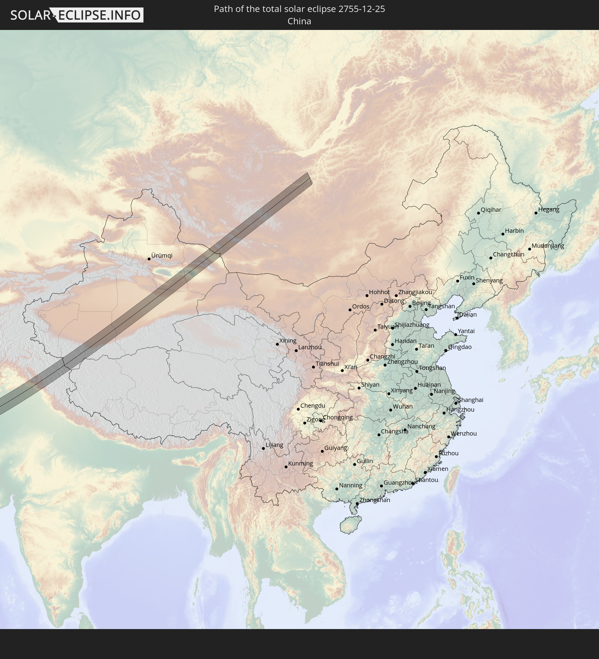
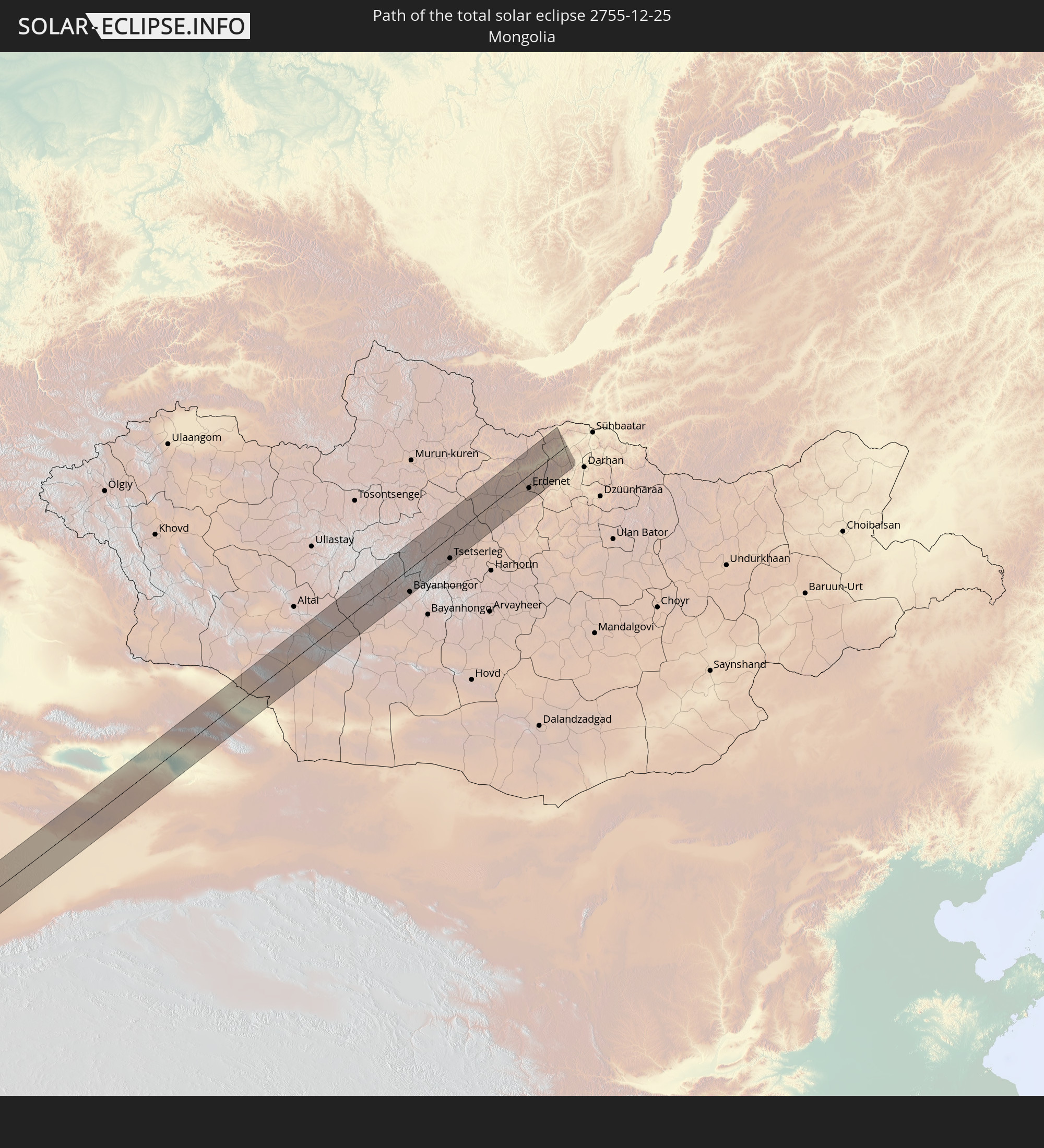
Detaillierte Länderkarten
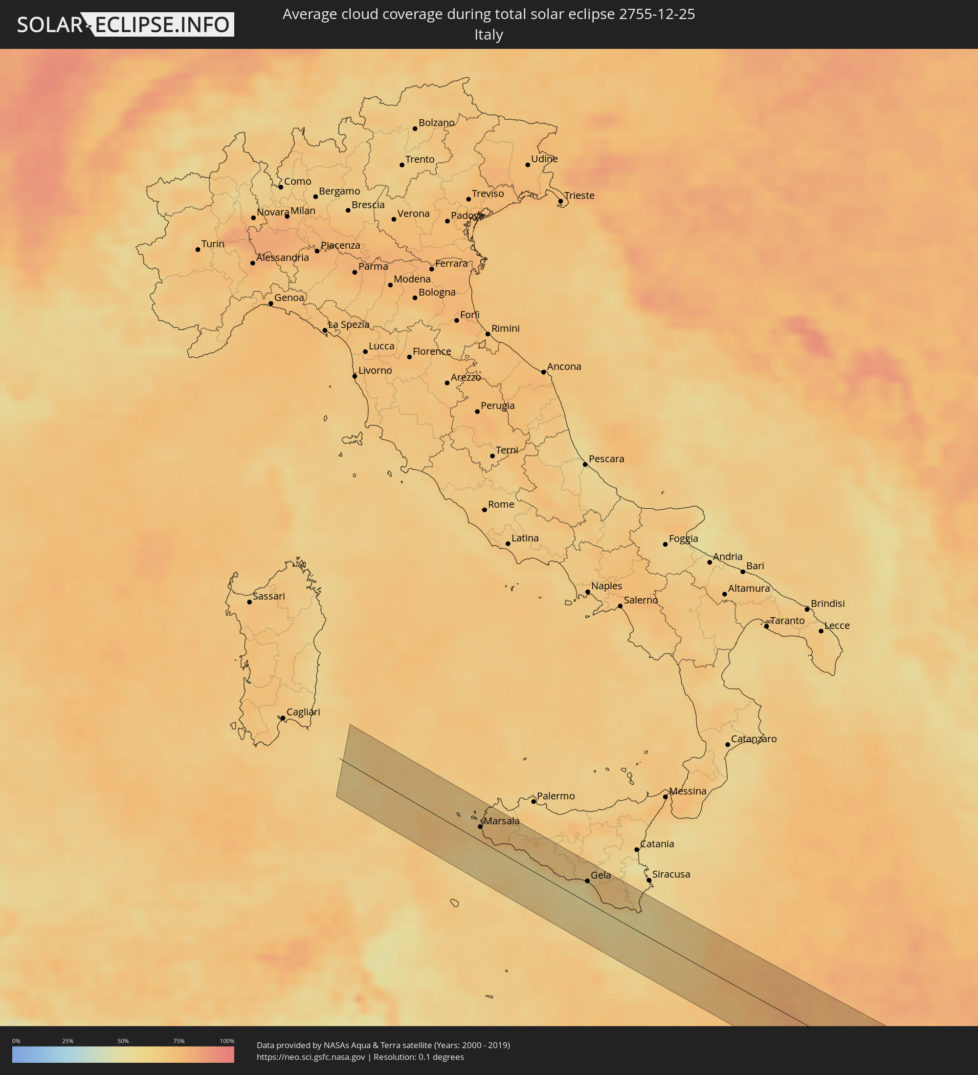 Italien
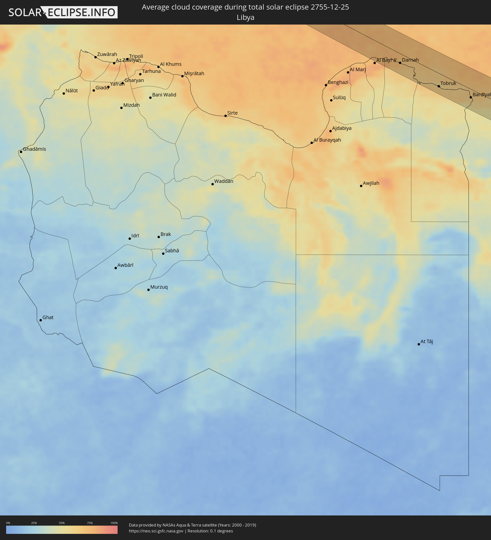 Libyen
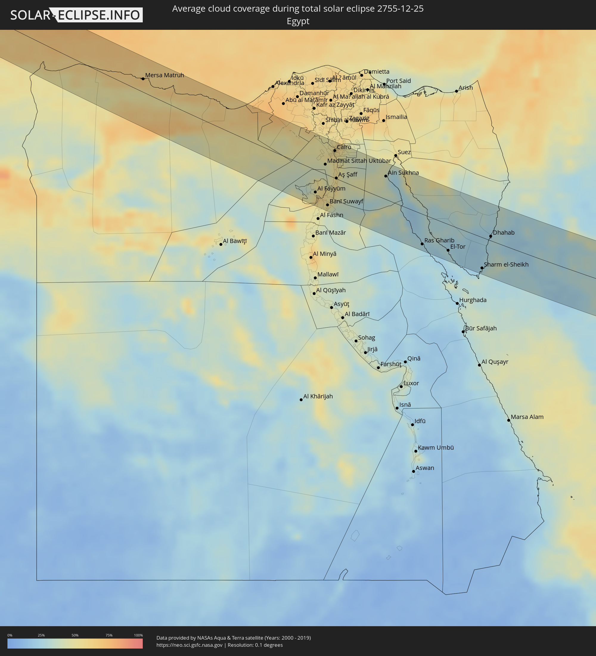 Ägypten
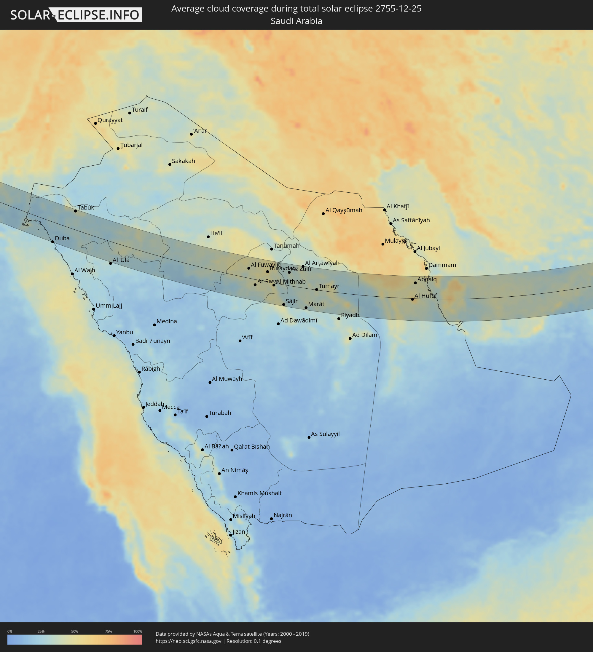 Saudi-Arabien
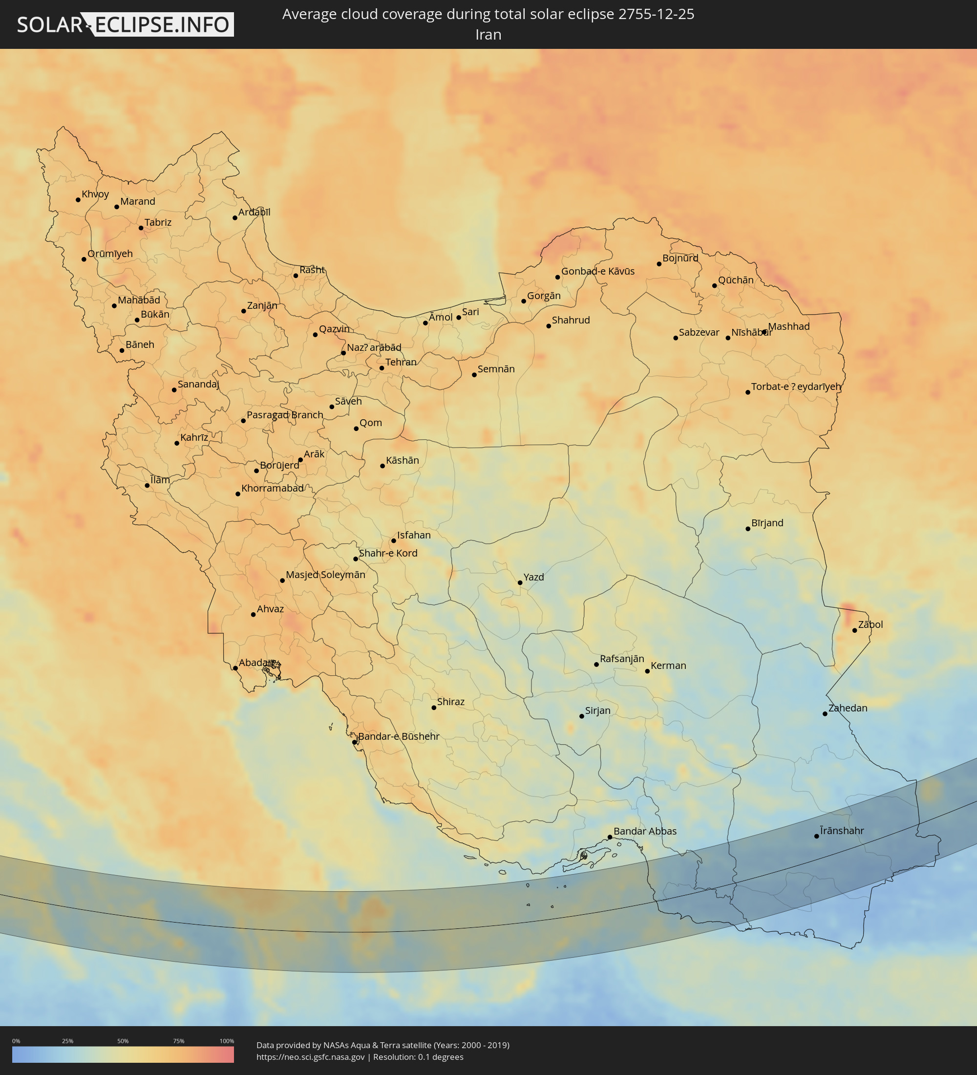 Iran
Iran
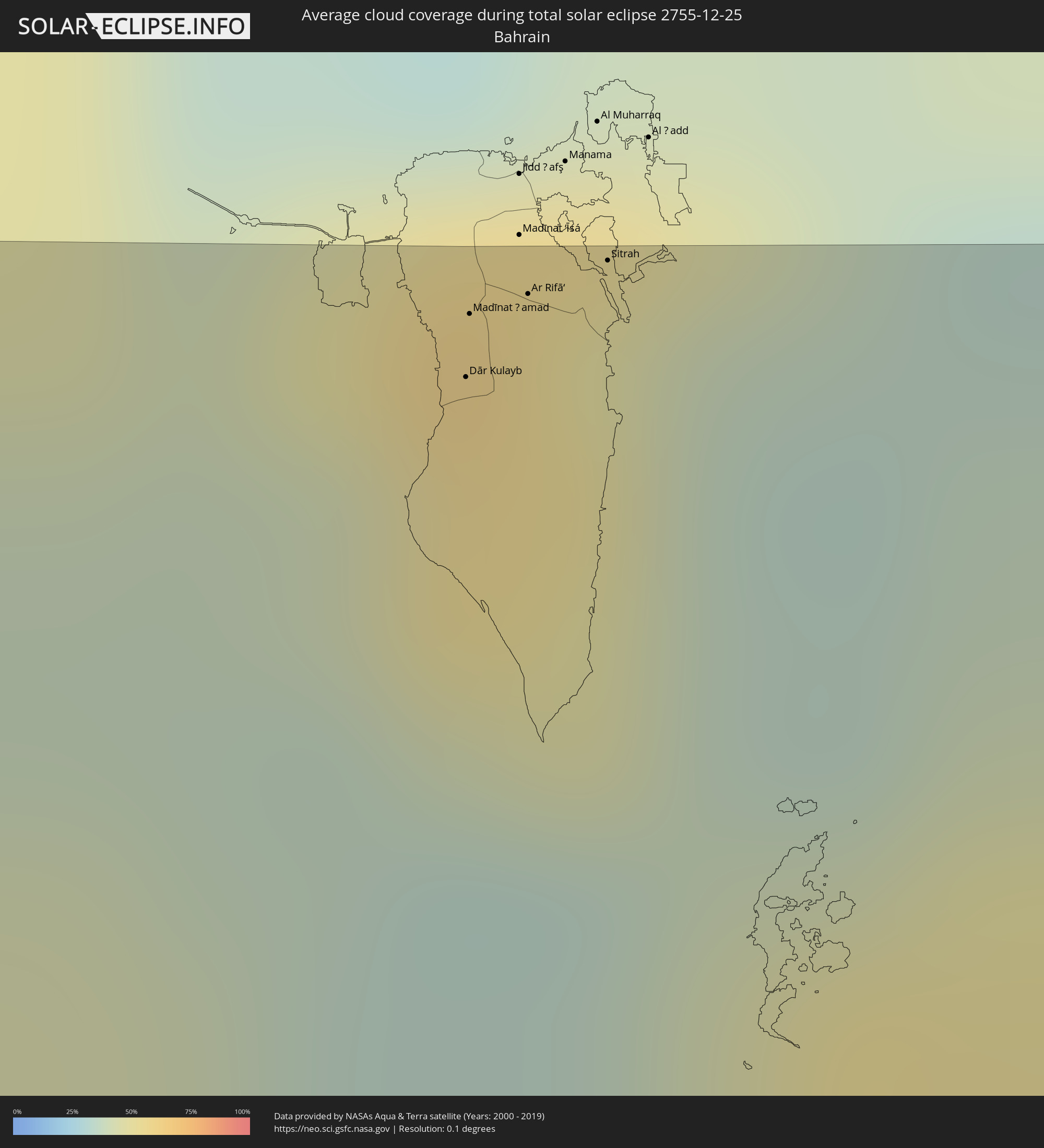 Bahrain
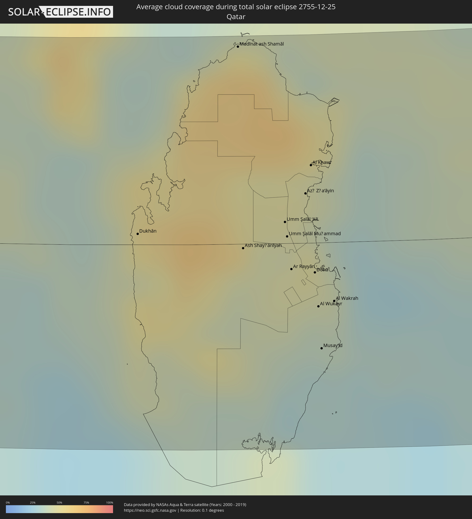 Katar
Katar
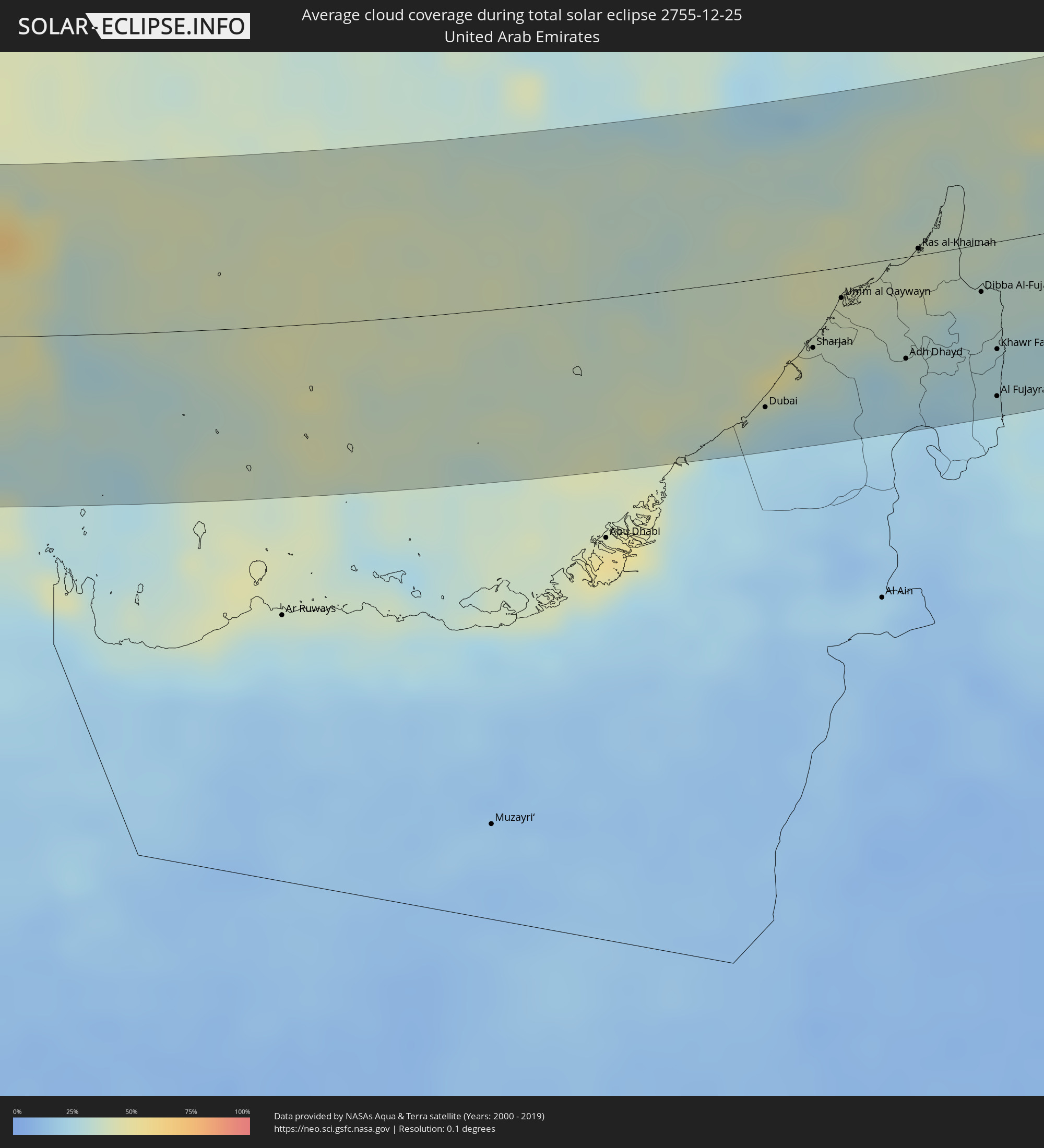 Vereinigte Arabische Emirate
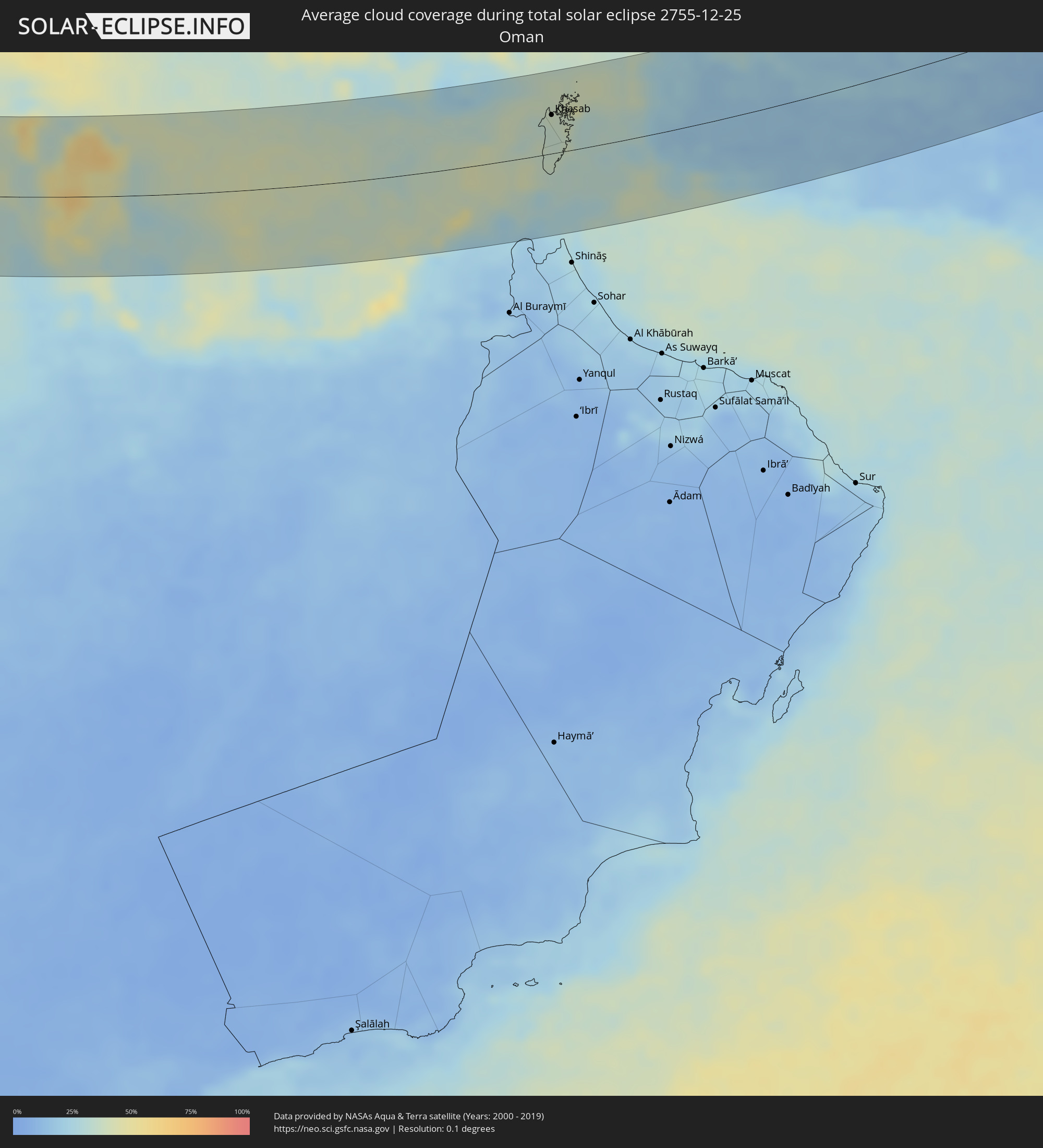 Oman
Oman
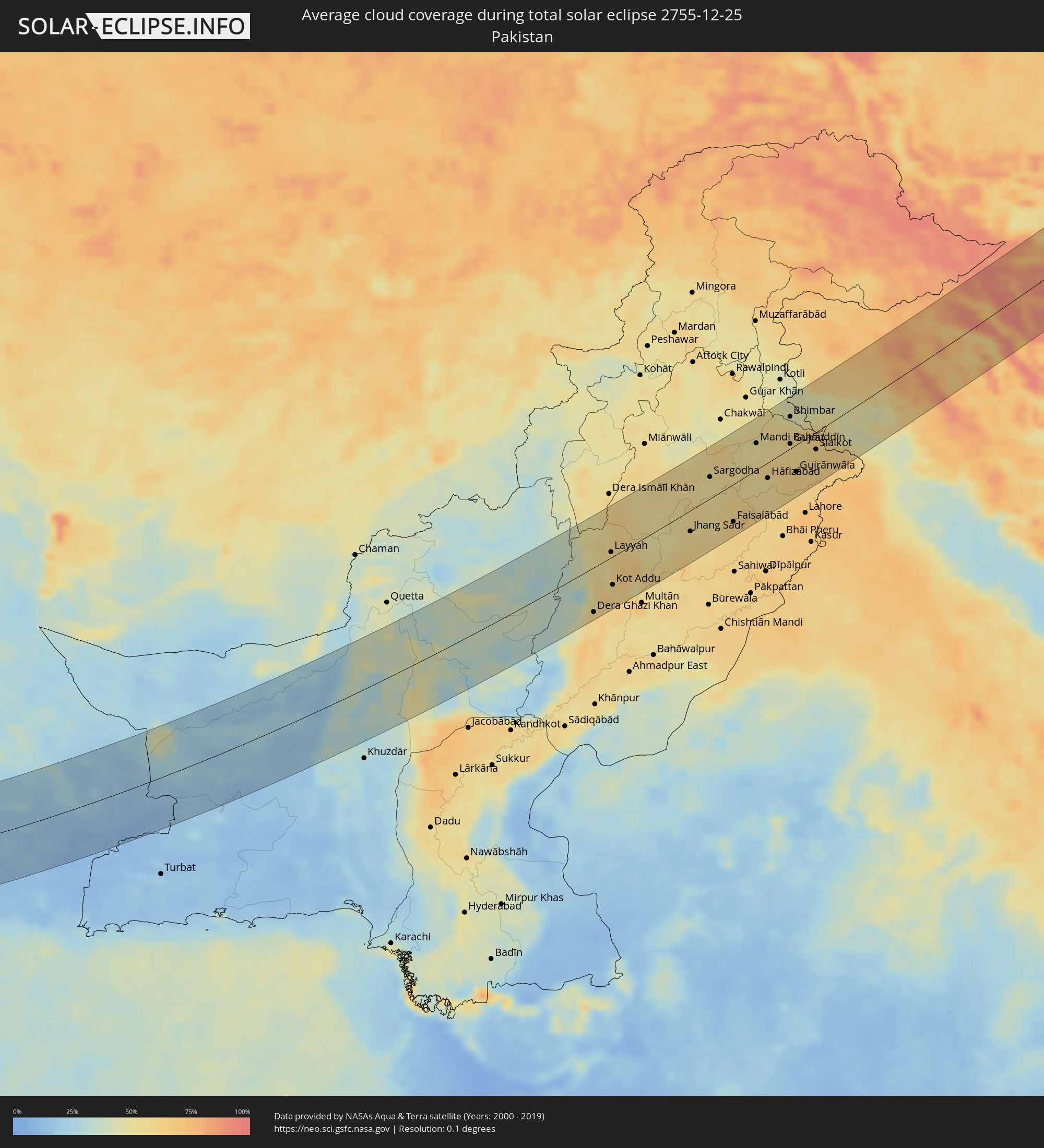 Pakistan
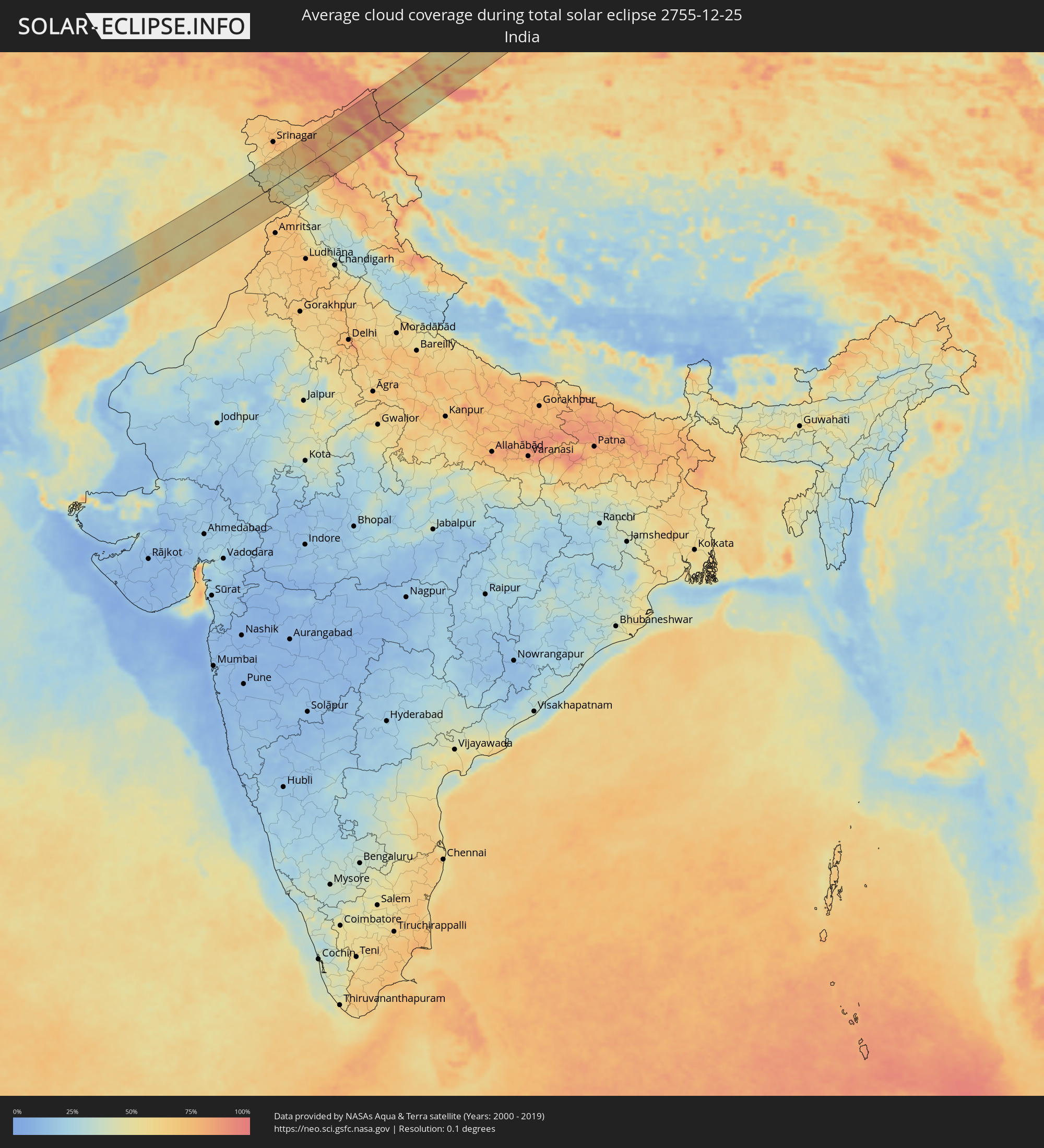 Indien
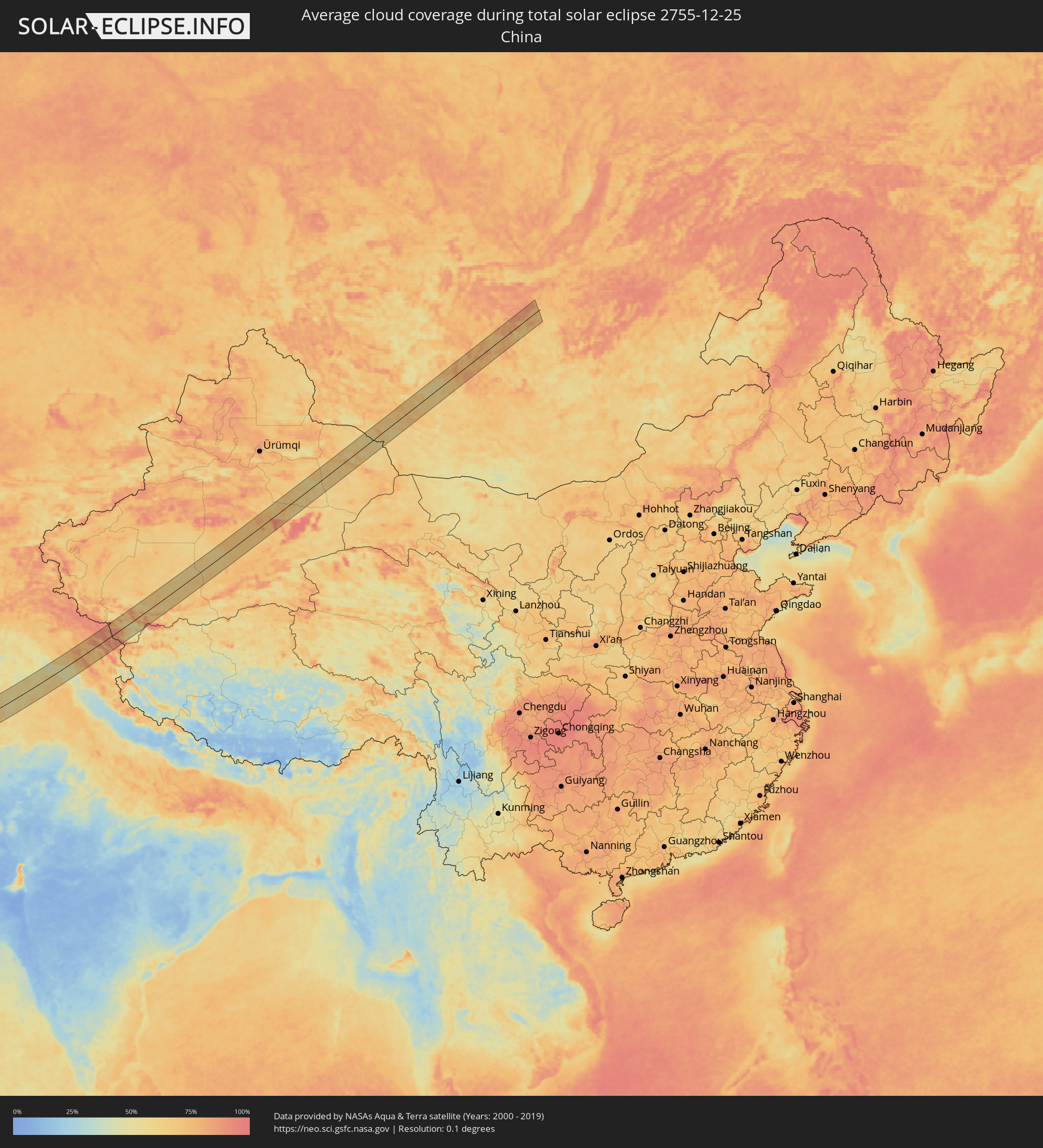 Volksrepublik China
 Mongolei
Orte im Finsternispfad
Die nachfolgene Tabelle zeigt Städte und Orte mit mehr als 5.000 Einwohnern, die sich im Finsternispfad befinden. Städte mit mehr als 100.000 Einwohnern sind dick gekennzeichnet. Mit einem Klick auf den Ort öffnet sich eine Detailkarte die die Lage des jeweiligen Ortes zusammen mit dem Verlauf der zentralen Finsternis präsentiert.
| Ort | Typ | Dauer der Verfinsterung | Ortszeit bei maximaler Verfinsterung | Entfernung zur Zentrallinie | Ø Bewölkung |
|
Marsala, Sicily
|
total | - | 07:39:01 UTC+01:00 | 18 km | 63% |
|
Trapani, Sicily
|
total | - | 07:39:20 UTC+01:00 | 43 km | 65% |
|
Mazara del Vallo, Sicily
|
total | - | 07:38:57 UTC+01:00 | 11 km | 68% |
|
Castelvetrano, Sicily
|
total | - | 07:39:07 UTC+01:00 | 22 km | 71% |
|
Sciacca, Sicily
|
total | - | 07:39:06 UTC+01:00 | 18 km | 57% |
|
Ribera, Sicily
|
total | - | 07:39:13 UTC+01:00 | 25 km | 61% |
|
Agrigento, Sicily
|
total | - | 07:39:12 UTC+01:00 | 21 km | 60% |
|
Palma di Montechiaro, Sicily
|
total | - | 07:39:11 UTC+01:00 | 18 km | 63% |
|
Canicattì, Sicily
|
total | - | 07:39:26 UTC+01:00 | 38 km | 66% |
|
Licata, Sicily
|
total | - | 07:39:13 UTC+01:00 | 17 km | 53% |
|
Gela, Sicily
|
total | - | 07:39:23 UTC+01:00 | 28 km | 53% |
|
Niscemi, Sicily
|
total | - | 07:39:35 UTC+01:00 | 41 km | 66% |
|
Vittoria, Sicily
|
total | - | 07:39:27 UTC+01:00 | 28 km | 69% |
|
Ragusa, Sicily
|
total | - | 07:39:34 UTC+01:00 | 35 km | 67% |
|
Rosolini, Sicily
|
total | - | 07:39:36 UTC+01:00 | 35 km | 65% |
|
Pachino, Sicily
|
total | - | 07:39:35 UTC+01:00 | 30 km | 55% |
|
Avola, Sicily
|
total | - | 07:39:51 UTC+01:00 | 51 km | 60% |
|
Al Qubbah, Darnah
|
total | - | 08:41:40 UTC+02:00 | 45 km | 78% |
|
Darnah, Darnah
|
total | - | 08:42:05 UTC+02:00 | 27 km | 73% |
|
Tobruk, Sha‘bīyat al Buţnān
|
total | - | 08:42:53 UTC+02:00 | 38 km | 65% |
|
Bardīyah, Sha‘bīyat al Buţnān
|
total | - | 08:43:51 UTC+02:00 | 25 km | 62% |
|
Mersa Matruh, Matruh
|
total | - | 08:46:09 UTC+02:00 | 24 km | 65% |
|
Ibshawāy, Faiyum
|
total | - | 08:49:09 UTC+02:00 | 43 km | 41% |
|
Iţsā, Faiyum
|
total | - | 08:49:12 UTC+02:00 | 51 km | 54% |
|
Al Fayyūm, Faiyum
|
total | - | 08:49:21 UTC+02:00 | 42 km | 51% |
|
Ţāmiyah, Faiyum
|
total | - | 08:49:41 UTC+02:00 | 20 km | 58% |
|
Ashmūn, Monufia
|
total | - | 08:50:27 UTC+02:00 | 64 km | 48% |
|
Madīnat Sittah Uktūbar, Giza
|
total | - | 08:50:07 UTC+02:00 | 18 km | 42% |
|
Banī Suwayf, Beni Suweif
|
total | - | 08:49:32 UTC+02:00 | 56 km | 51% |
|
Awsīm, Giza
|
total | - | 08:50:32 UTC+02:00 | 53 km | 53% |
|
Al Qanāţir al Khayrīyah, Qalyubia
|
total | - | 08:50:36 UTC+02:00 | 60 km | 49% |
|
Al Wāsiţah, Faiyum
|
total | - | 08:49:56 UTC+02:00 | 25 km | 53% |
|
Cairo, Cairo
|
total | - | 08:50:39 UTC+02:00 | 51 km | 55% |
|
Al ‘Ayyāţ, Giza
|
total | - | 08:50:16 UTC+02:00 | 6 km | 56% |
|
Aş Şaff, Giza
|
total | - | 08:50:15 UTC+02:00 | 1 km | 56% |
|
Ḩalwān, Cairo
|
total | - | 08:50:32 UTC+02:00 | 30 km | 55% |
|
Ain Sukhna, Suez
|
total | - | 08:51:55 UTC+02:00 | 43 km | 42% |
|
Ras Gharib, Red Sea
|
total | - | 08:52:04 UTC+02:00 | 57 km | 27% |
|
Tabuk, Tabuk
|
total | - | 09:58:14 UTC+03:00 | 66 km | 36% |
|
Ar Rass, Al-Qassim
|
total | - | 10:10:39 UTC+03:00 | 22 km | 39% |
|
Al Bukayrīyah, Al-Qassim
|
total | - | 10:11:13 UTC+03:00 | 11 km | 44% |
|
Buraydah, Al-Qassim
|
total | - | 10:12:04 UTC+03:00 | 37 km | 46% |
|
Unaizah, Al-Qassim
|
total | - | 10:11:56 UTC+03:00 | 11 km | 48% |
|
Al Mithnab, Al-Qassim
|
total | - | 10:12:19 UTC+03:00 | 9 km | 49% |
|
Sājir, Ar Riyāḑ
|
total | - | 10:12:43 UTC+03:00 | 77 km | 45% |
|
Az Zulfi, Ar Riyāḑ
|
total | - | 10:14:00 UTC+03:00 | 49 km | 35% |
|
Al Arţāwīyah, Ar Riyāḑ
|
total | - | 10:15:24 UTC+03:00 | 80 km | 42% |
|
Al Hufūf, Eastern Province
|
total | - | 10:25:07 UTC+03:00 | 5 km | 52% |
|
Al Qurayn, Eastern Province
|
total | - | 10:25:16 UTC+03:00 | 9 km | 62% |
|
Al Baţţālīyah, Eastern Province
|
total | - | 10:25:20 UTC+03:00 | 3 km | 52% |
|
Al Jubayl, Eastern Province
|
total | - | 10:25:21 UTC+03:00 | 0 km | 55% |
|
Al Qārah, Eastern Province
|
total | - | 10:25:24 UTC+03:00 | 2 km | 55% |
|
Al Munayzilah, Eastern Province
|
total | - | 10:25:23 UTC+03:00 | 2 km | 55% |
|
Abqaiq, Eastern Province
|
total | - | 10:25:45 UTC+03:00 | 60 km | 43% |
|
Aţ Ţaraf, Eastern Province
|
total | - | 10:25:31 UTC+03:00 | 4 km | 55% |
|
Dār Kulayb, Southern Governorate
|
total | - | 10:27:58 UTC+03:00 | 76 km | 55% |
|
Madīnat Ḩamad, Central Governorate
|
total | - | 10:28:00 UTC+03:00 | 81 km | 55% |
|
Ar Rifā‘, Southern Governorate
|
total | - | 10:28:08 UTC+03:00 | 83 km | 52% |
|
Sitrah, Manama
|
total | - | 10:28:20 UTC+03:00 | 86 km | 49% |
|
Dukhān, Baladīyat ar Rayyān
|
total | - | 10:28:18 UTC+03:00 | 4 km | 44% |
|
Madīnat ash Shamāl, Madīnat ash Shamāl
|
total | - | 10:29:49 UTC+03:00 | 83 km | 61% |
|
Ash Shayḩānīyah, Baladīyat ar Rayyān
|
total | - | 10:29:26 UTC+03:00 | 2 km | 45% |
|
Umm Şalāl ‘Alī, Baladīyat Umm Şalāl
|
total | - | 10:29:57 UTC+03:00 | 9 km | 44% |
|
Umm Şalāl Muḩammad, Baladīyat Umm Şalāl
|
total | - | 10:29:56 UTC+03:00 | 3 km | 46% |
|
Ar Rayyān, Baladīyat ar Rayyān
|
total | - | 10:29:55 UTC+03:00 | 11 km | 45% |
|
Az̧ Z̧a‘āyin, Baladīyat az̧ Z̧a‘āyin
|
total | - | 10:30:14 UTC+03:00 | 21 km | 42% |
|
Al Khawr, Al Khawr
|
total | - | 10:30:22 UTC+03:00 | 33 km | 45% |
|
Doha, Baladīyat ad Dawḩah
|
total | - | 10:30:10 UTC+03:00 | 13 km | 43% |
|
Al Wukayr, Al Wakrah
|
total | - | 10:30:08 UTC+03:00 | 27 km | 38% |
|
Musay‘īd, Al Wakrah
|
total | - | 10:30:04 UTC+03:00 | 45 km | 32% |
|
Al Wakrah, Al Wakrah
|
total | - | 10:30:19 UTC+03:00 | 25 km | 38% |
|
Dubai, Dubai
|
total | - | 11:39:50 UTC+04:00 | 65 km | 30% |
|
Sharjah, Ash Shāriqah
|
total | - | 11:40:38 UTC+04:00 | 38 km | 36% |
|
Ajman, Ajman
|
total | - | 11:40:44 UTC+04:00 | 31 km | 38% |
|
Umm al Qaywayn, Umm al Qaywayn
|
total | - | 11:41:08 UTC+04:00 | 15 km | 40% |
|
Adh Dhayd, Ash Shāriqah
|
total | - | 11:41:52 UTC+04:00 | 51 km | 31% |
|
Ras al-Khaimah, Raʼs al Khaymah
|
total | - | 11:42:17 UTC+04:00 | 3 km | 41% |
|
Khasab, Musandam
|
total | - | 11:43:18 UTC+04:00 | 41 km | 35% |
|
Dibba Al-Fujairah, Al Fujayrah
|
total | - | 11:43:03 UTC+04:00 | 24 km | 32% |
|
Dibba Al-Hisn, Al Fujayrah
|
total | - | 11:43:06 UTC+04:00 | 21 km | 32% |
|
Al Fujayrah, Al Fujayrah
|
total | - | 11:43:02 UTC+04:00 | 77 km | 25% |
|
Khawr Fakkān, Ash Shāriqah
|
total | - | 11:43:09 UTC+04:00 | 54 km | 28% |
|
Īrānshahr, Sistan and Baluchestan
|
total | - | 11:25:37 UTC+03:30 | 45 km | 27% |
|
Qaşr-e Qand, Sistan and Baluchestan
|
total | - | 11:25:26 UTC+03:30 | 58 km | 18% |
|
Dera Ghazi Khan, Punjab
|
total | - | 13:20:37 UTC+05:00 | 65 km | 62% |
|
Jhang Sadr, Punjab
|
total | - | 13:24:18 UTC+05:00 | 30 km | 57% |
|
Sargodha, Punjab
|
total | - | 13:24:58 UTC+05:00 | 30 km | 55% |
|
Gojra, Punjab
|
total | - | 13:25:03 UTC+05:00 | 59 km | 56% |
|
Chiniot, Punjab
|
total | - | 13:25:38 UTC+05:00 | 19 km | 57% |
|
Faisalābād, Punjab
|
total | - | 13:25:52 UTC+05:00 | 53 km | 63% |
|
Mandi Bahāuddīn, Punjab
|
total | - | 13:26:36 UTC+05:00 | 37 km | 53% |
|
Shahkot, Punjab
|
total | - | 13:26:41 UTC+05:00 | 59 km | 60% |
|
Hāfizābād, Punjab
|
total | - | 13:27:03 UTC+05:00 | 22 km | 55% |
|
Jhelum, Punjab
|
total | - | 13:27:03 UTC+05:00 | 58 km | 55% |
|
Sheikhupura, Punjab
|
total | - | 13:27:40 UTC+05:00 | 70 km | 63% |
|
Bhimbar, Azad Kashmir
|
total | - | 13:27:45 UTC+05:00 | 44 km | 52% |
|
Gujrāt, Punjab
|
total | - | 13:27:48 UTC+05:00 | 6 km | 59% |
|
Gujrānwāla, Punjab
|
total | - | 13:28:03 UTC+05:00 | 38 km | 66% |
|
Kamoke, Punjab
|
total | - | 13:28:09 UTC+05:00 | 57 km | 62% |
|
Rajaori, Kashmir
|
total | - | 13:58:09 UTC+05:30 | 70 km | 44% |
|
Daska, Punjab
|
total | - | 13:28:22 UTC+05:00 | 31 km | 62% |
|
Nawānshahr, Kashmir
|
total | - | 13:58:40 UTC+05:30 | 2 km | 62% |
|
Sialkot, Punjab
|
total | - | 13:28:42 UTC+05:00 | 24 km | 63% |
|
Akhnūr, Kashmir
|
total | - | 13:59:03 UTC+05:30 | 1 km | 60% |
|
Norīa, Kashmir
|
total | - | 13:59:13 UTC+05:30 | 35 km | 62% |
|
Bishnāh, Kashmir
|
total | - | 13:59:19 UTC+05:30 | 29 km | 62% |
|
Jammu, Kashmir
|
total | - | 13:59:20 UTC+05:30 | 18 km | 61% |
|
Kulgam, Kashmir
|
total | - | 13:59:29 UTC+05:30 | 59 km | 63% |
|
Bijbehara, Kashmir
|
total | - | 13:59:38 UTC+05:30 | 68 km | 65% |
|
Sāmba, Kashmir
|
total | - | 13:59:51 UTC+05:30 | 47 km | 59% |
|
Udhampur, Kashmir
|
total | - | 13:59:49 UTC+05:30 | 14 km | 46% |
|
Anantnag, Kashmir
|
total | - | 13:59:44 UTC+05:30 | 60 km | 62% |
|
Hirānagar, Kashmir
|
total | - | 14:00:09 UTC+05:30 | 65 km | 59% |
|
Doda, Kashmir
|
total | - | 14:00:35 UTC+05:30 | 14 km | 48% |
|
Bhadarwāh, Kashmir
|
total | - | 14:00:56 UTC+05:30 | 39 km | 50% |
|
Kishtwār, Kashmir
|
total | - | 14:00:58 UTC+05:30 | 10 km | 57% |
|
Padam, Kashmir
|
total | - | 14:03:02 UTC+05:30 | 53 km | 69% |
|
Leh, Kashmir
|
total | - | 14:04:08 UTC+05:30 | 25 km | 65% |
|
Bayanhongor, Bayanhongor
|
total | - | 16:53:22 UTC+08:00 | 47 km | 60% |
|
Tsetserleg, Arhangay
|
total | - | 16:53:33 UTC+08:00 | 42 km | 76% |
|
Bulgan, Bulgan
|
total | - | 16:53:31 UTC+08:00 | 20 km | 69% |
|
Erdenet, Orhon
|
total | - | 16:53:37 UTC+08:00 | 25 km | 59% |