Totale Sonnenfinsternis vom 15.12.2764
| Wochentag: | Dienstag |
| Maximale Dauer der Verfinsterung: | 04m12s |
| Maximale Breite des Finsternispfades: | 184 km |
| Saroszyklus: | 154 |
| Bedeckungsgrad: | 100% |
| Magnitude: | 1.0443 |
| Gamma: | 0.5984 |
Wo kann man die Sonnenfinsternis vom 15.12.2764 sehen?
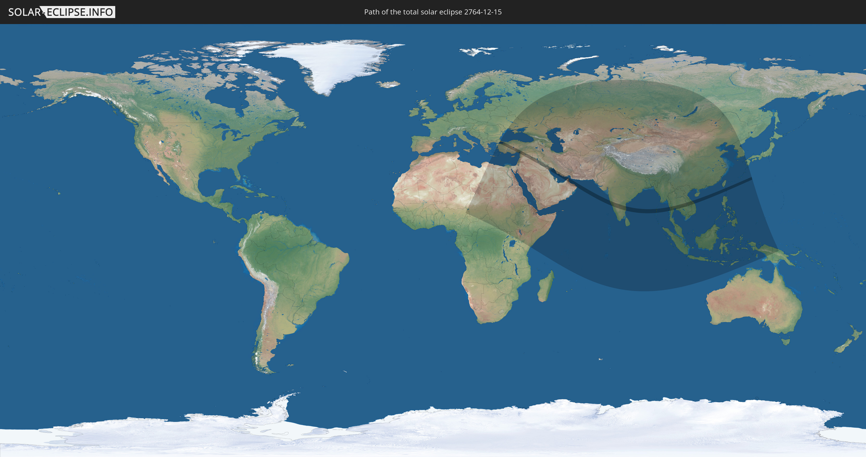
Die Sonnenfinsternis am 15.12.2764 kann man in 76 Ländern als partielle Sonnenfinsternis beobachten.
Der Finsternispfad verläuft durch 15 Länder. Nur in diesen Ländern ist sie als totale Sonnenfinsternis zu sehen.
In den folgenden Ländern ist die Sonnenfinsternis total zu sehen
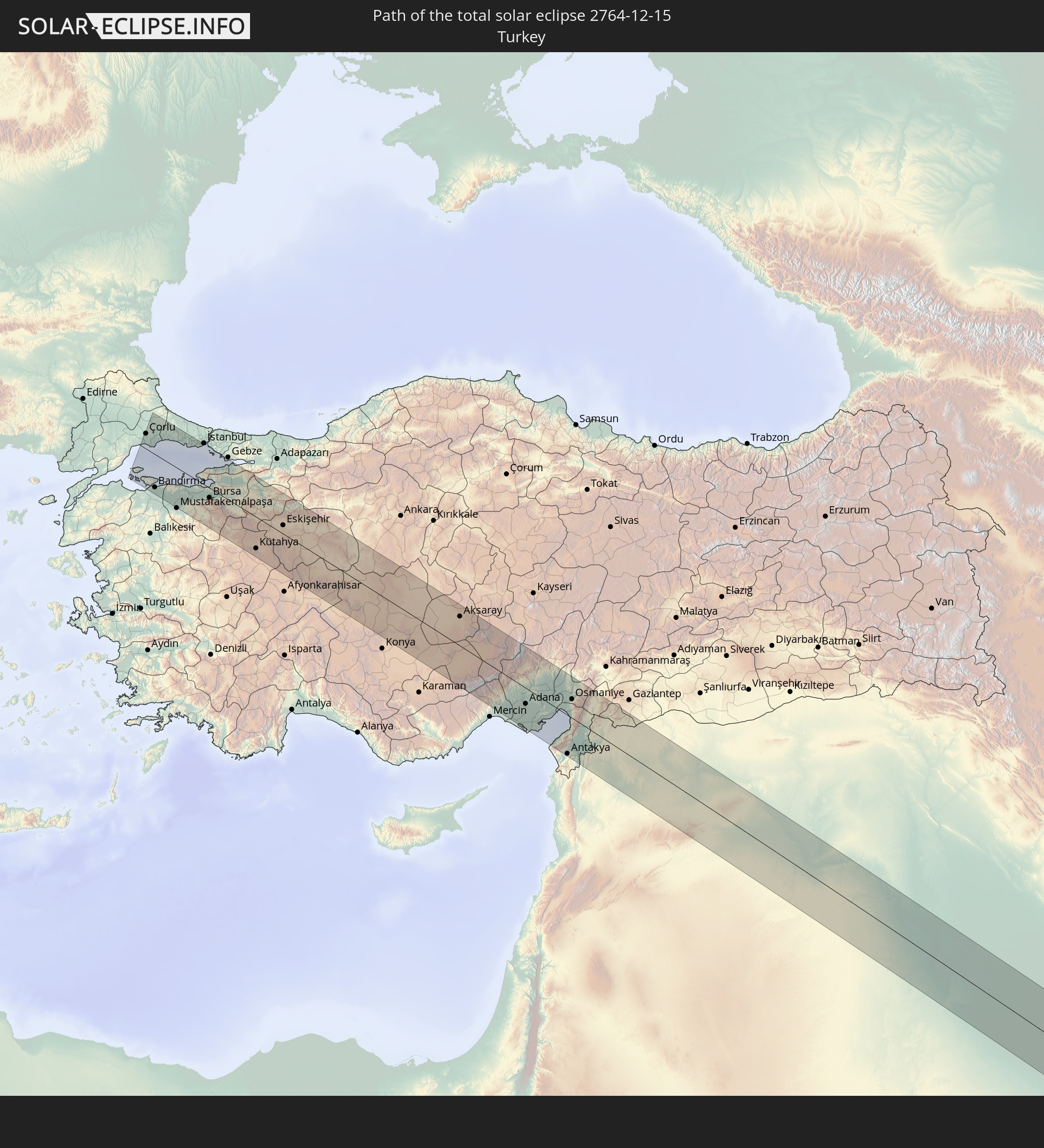 Türkei
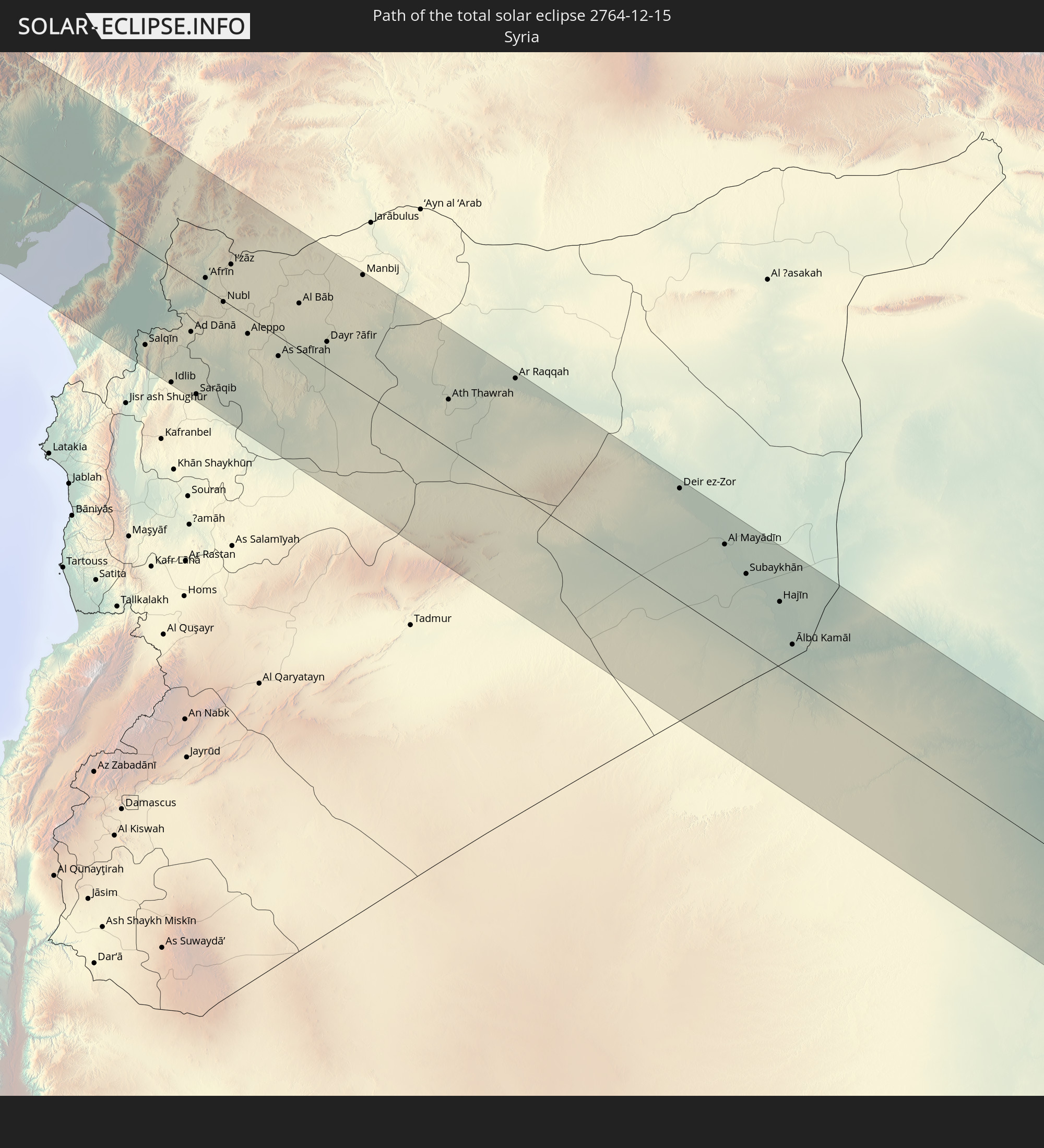 Syrien
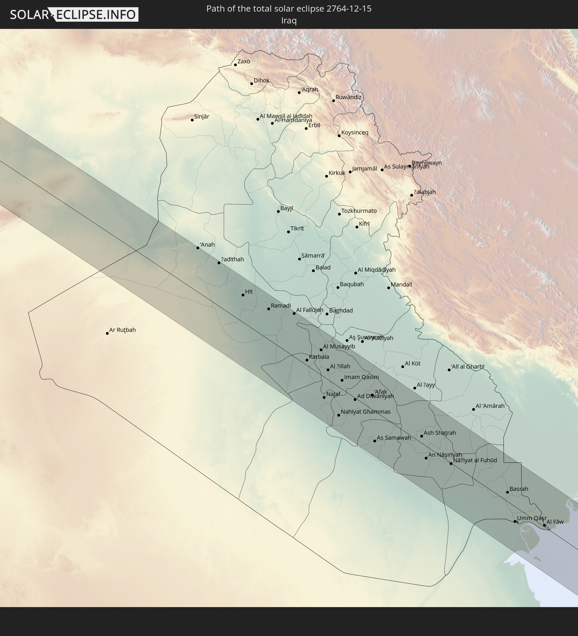 Irak
Irak
 Iran
Iran
 Kuwait
 Vereinigte Arabische Emirate
 Oman
Oman
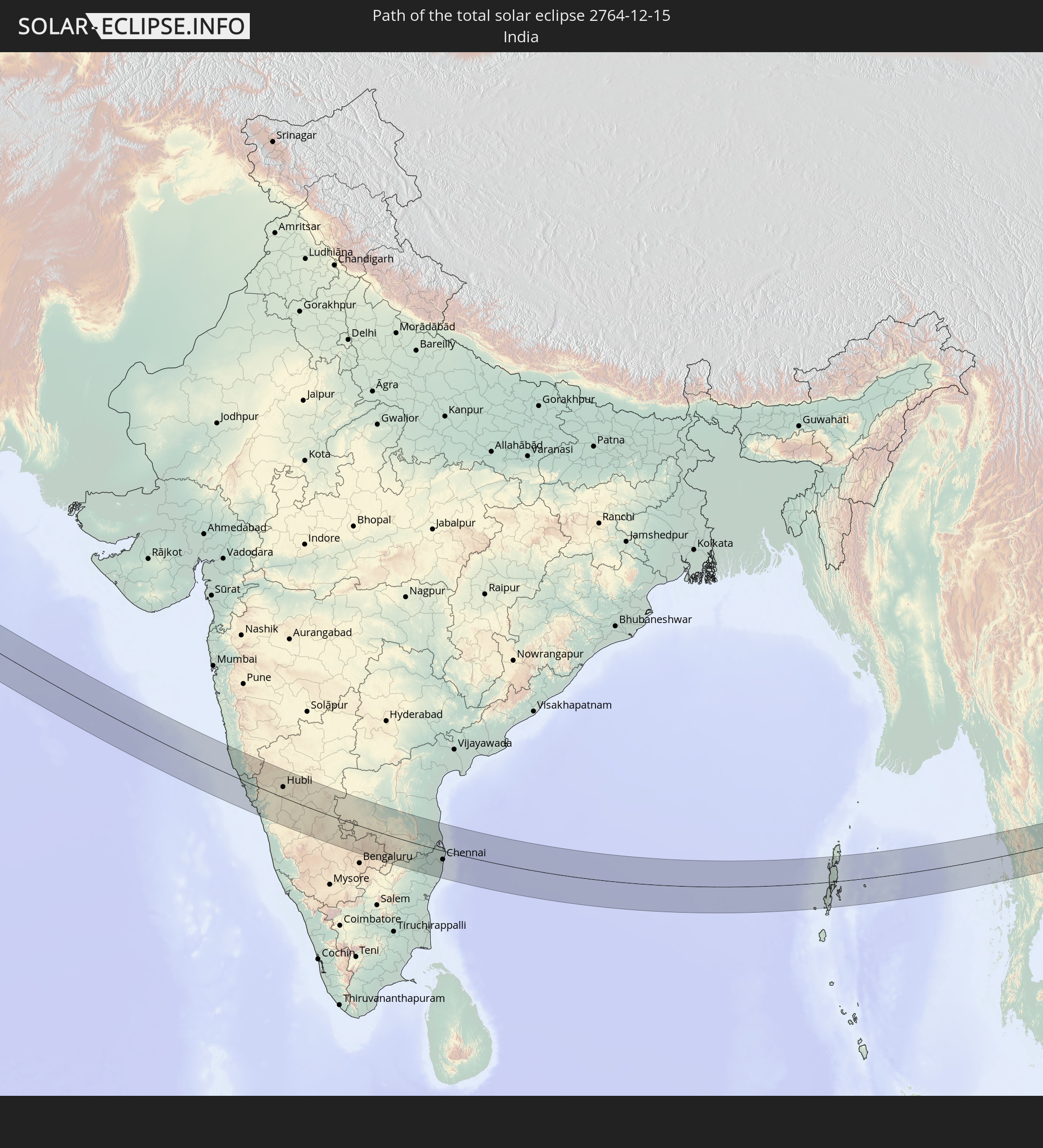 Indien
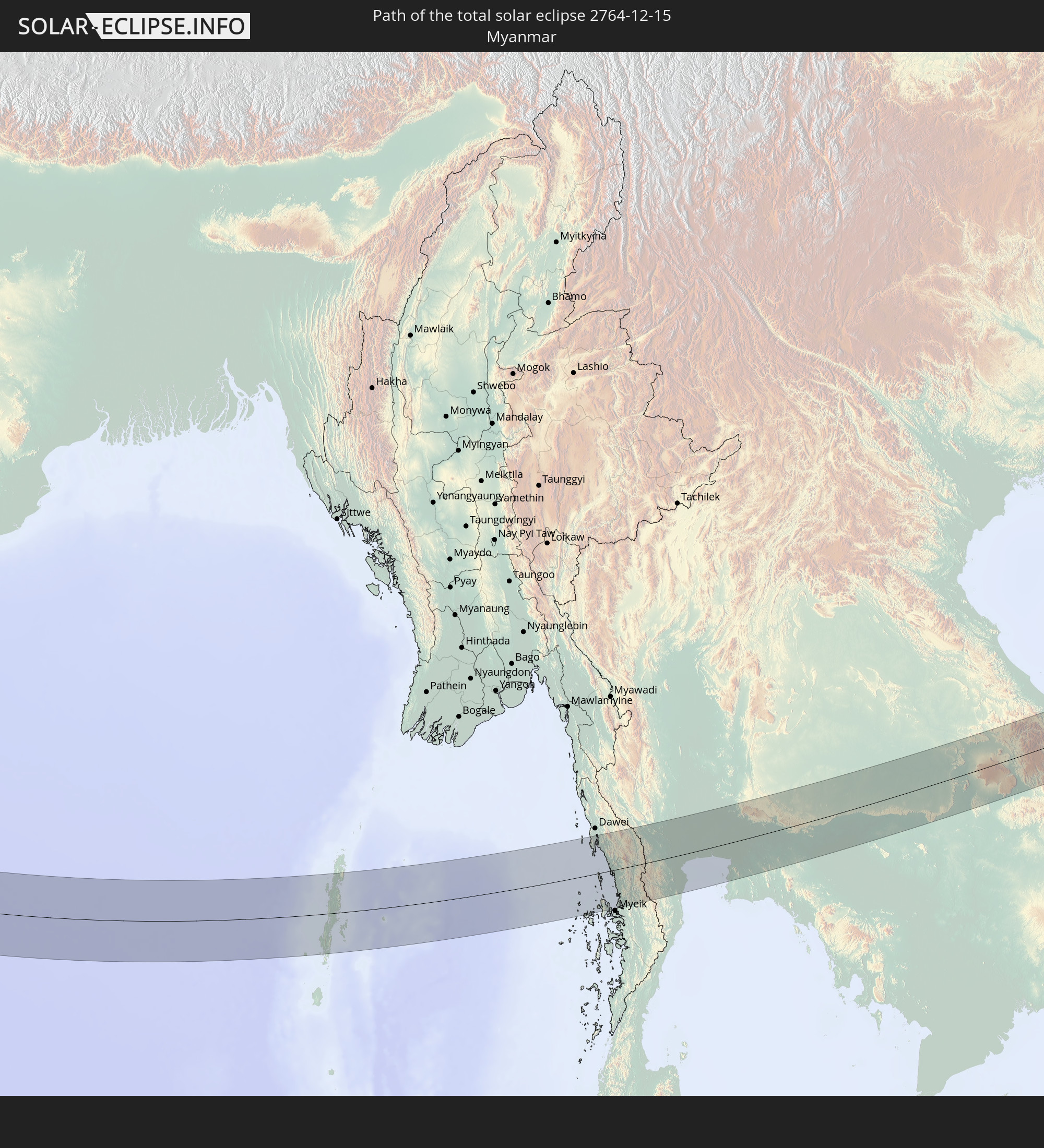 Myanmar
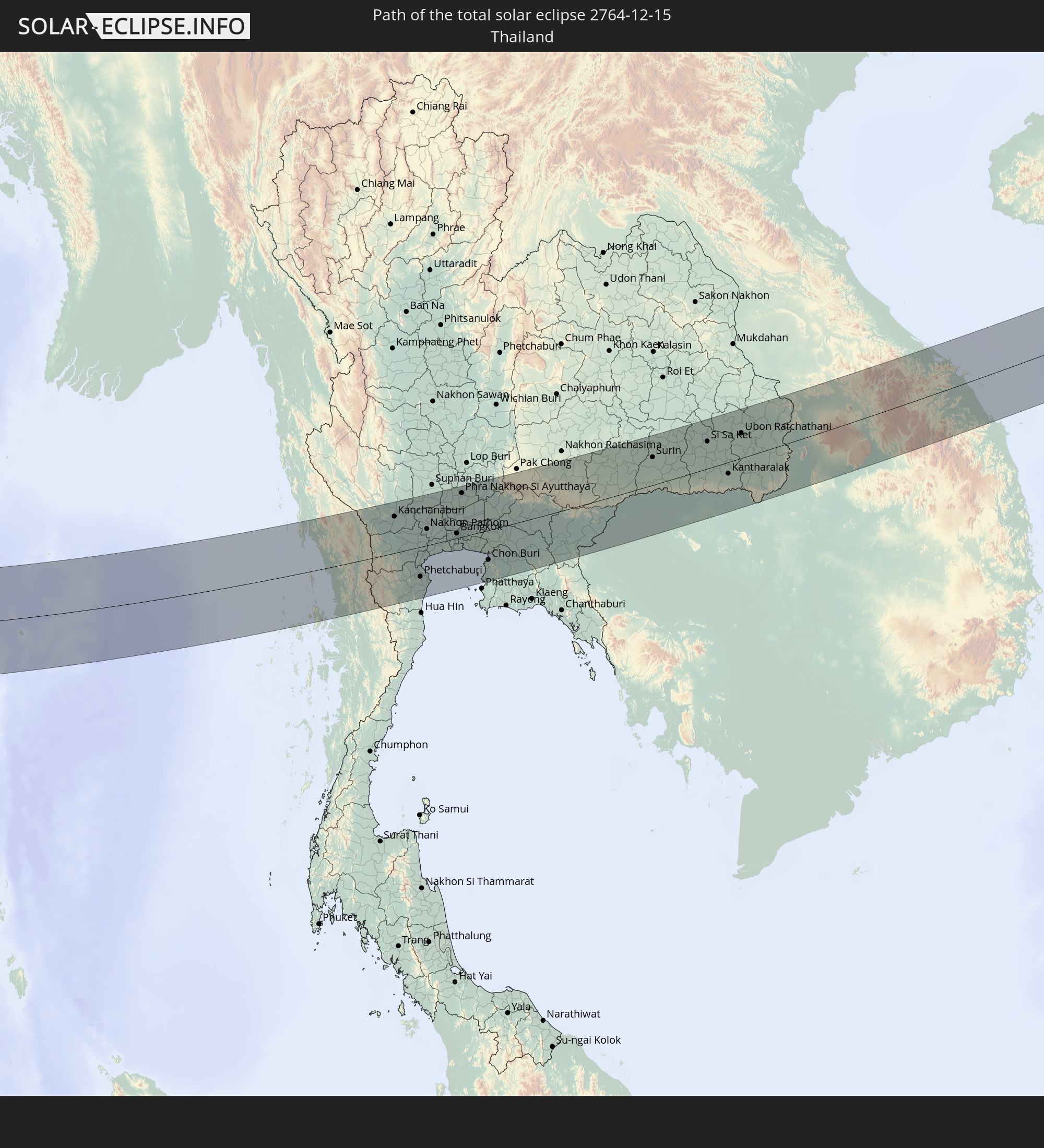 Thailand
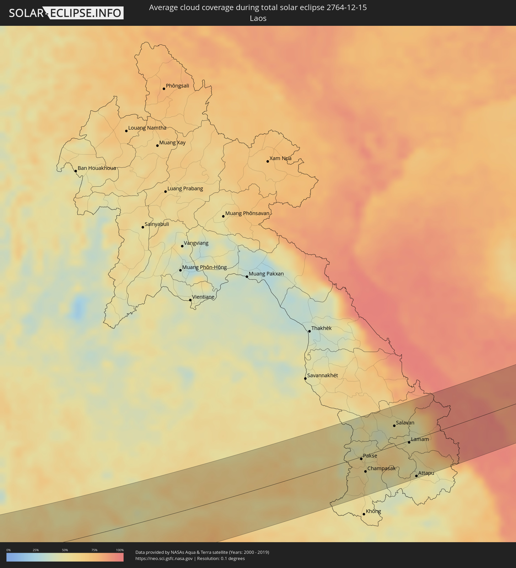
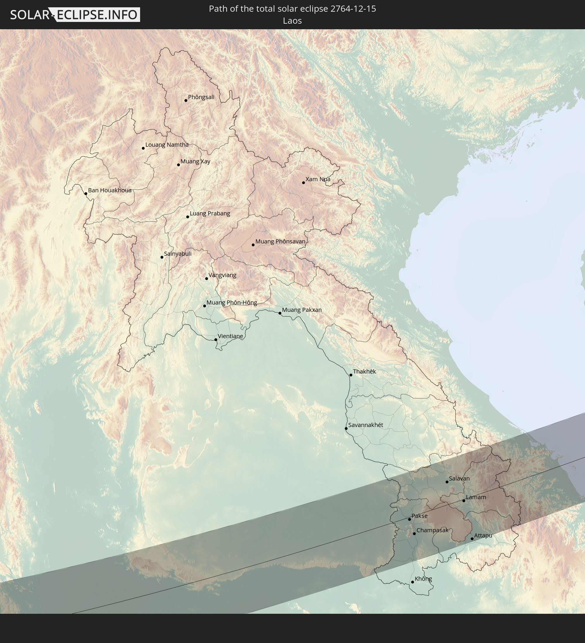 Laos
Laos
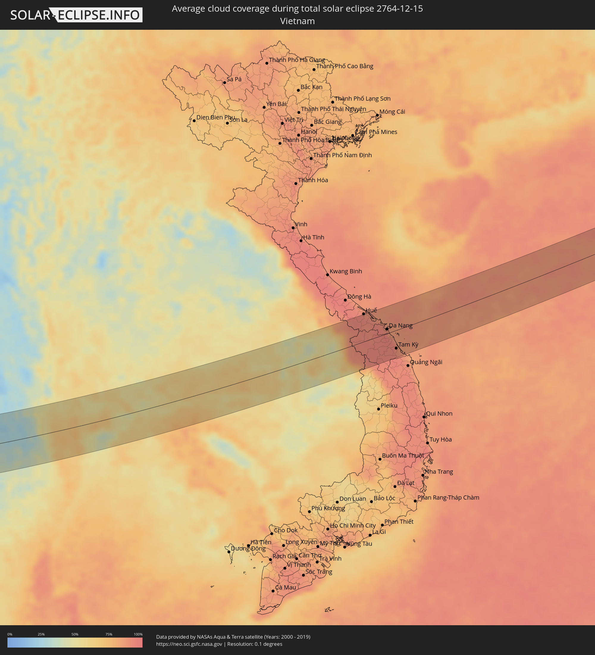
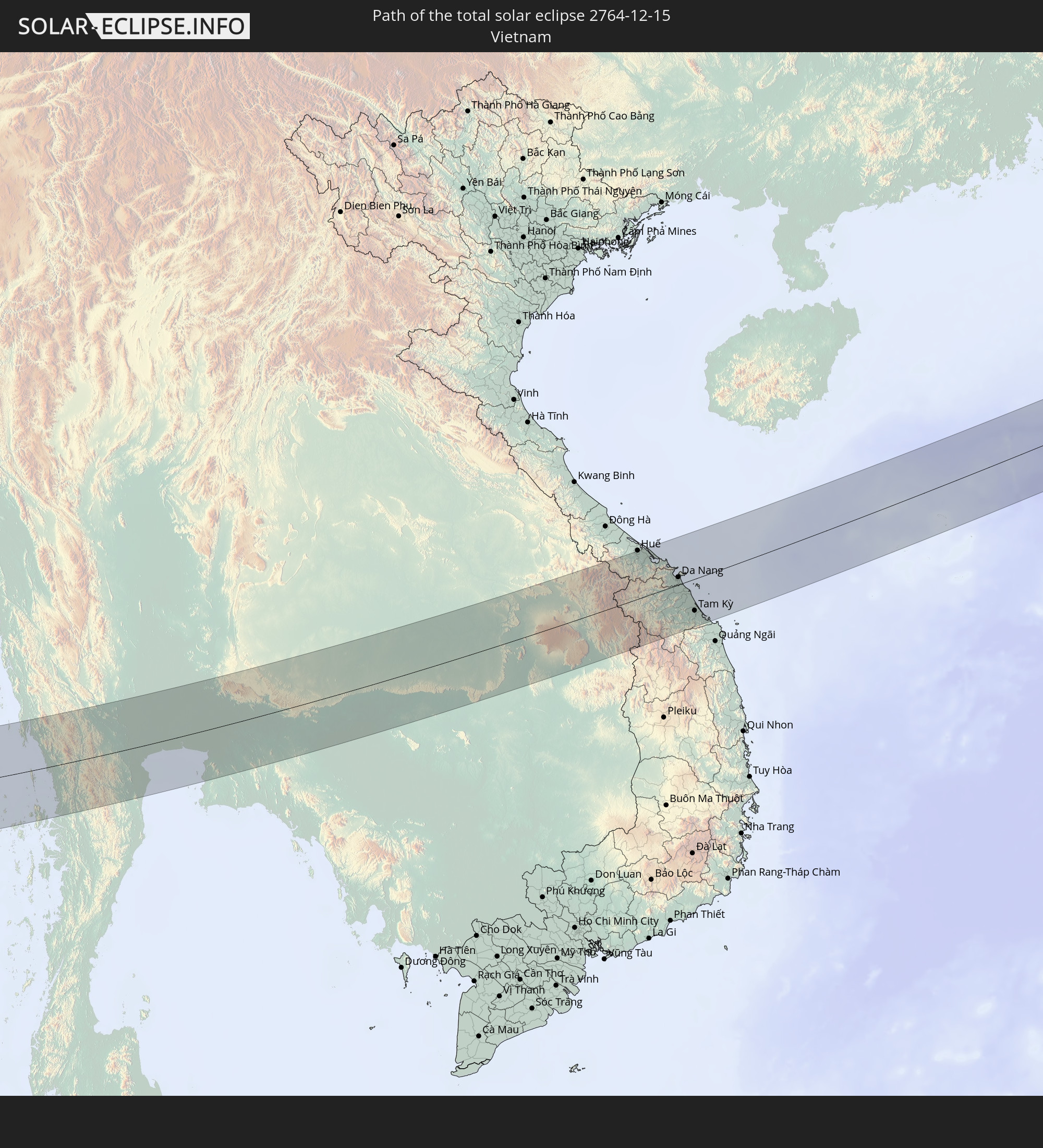 Vietnam
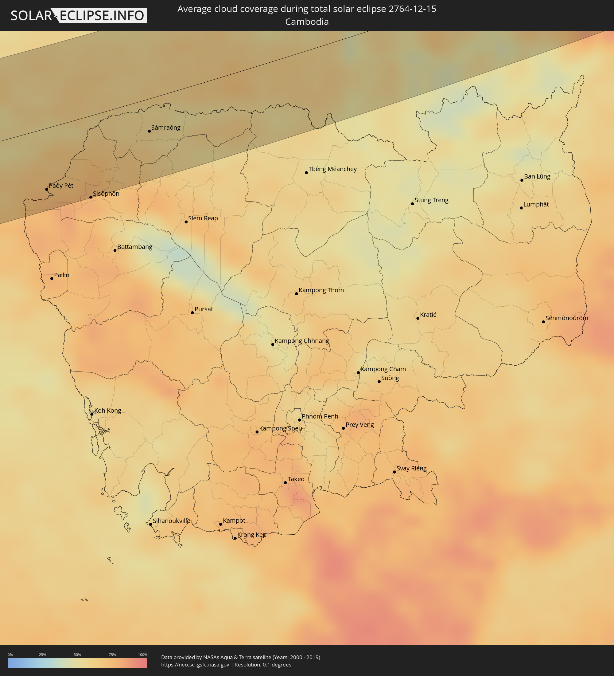
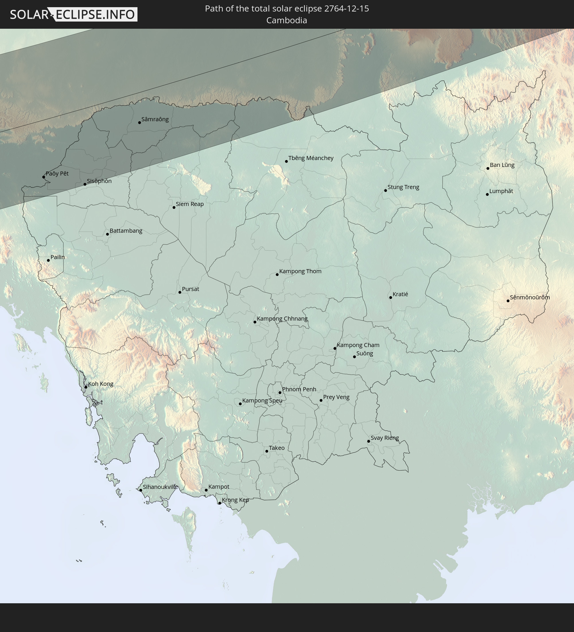 Kambodscha
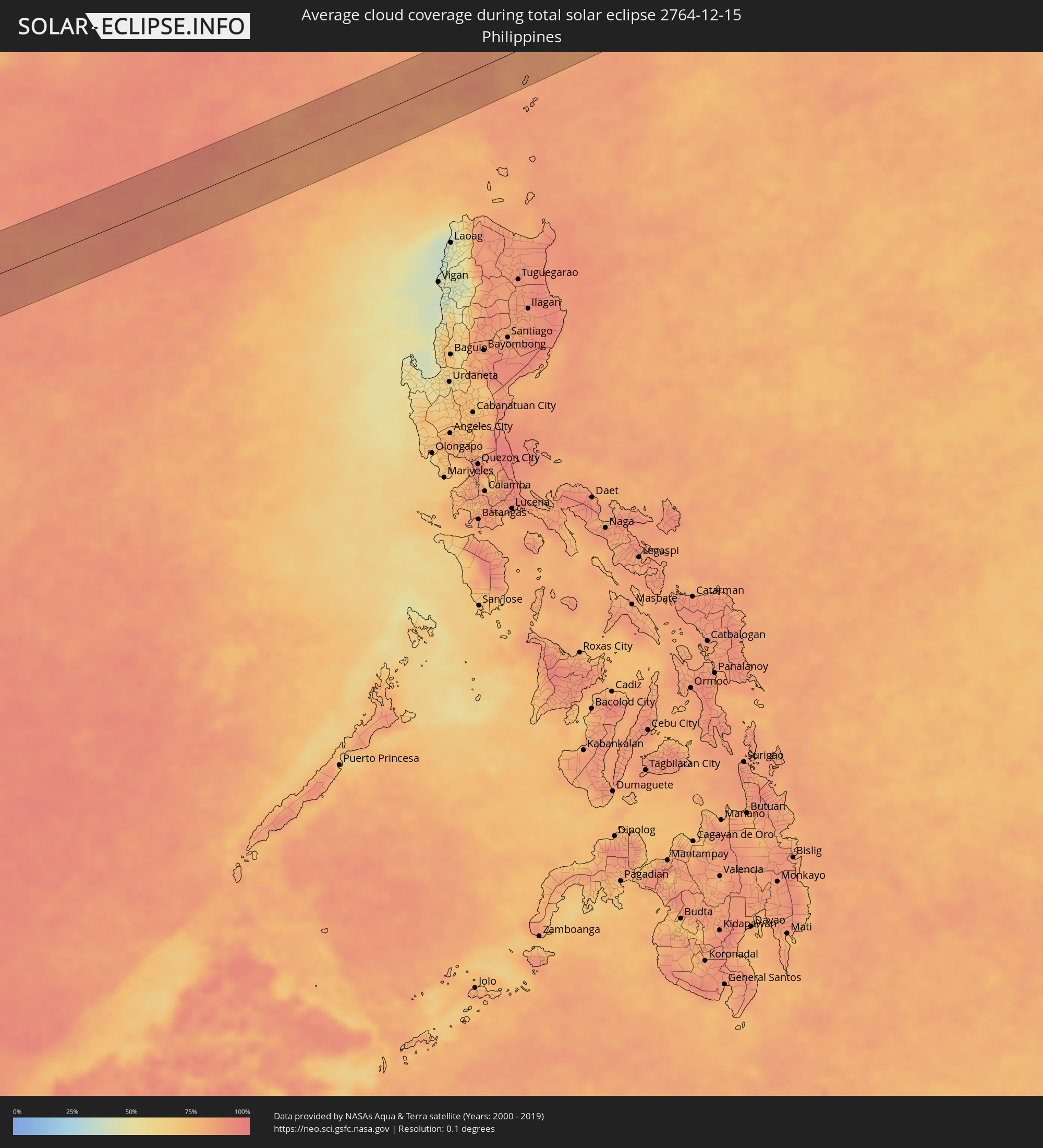
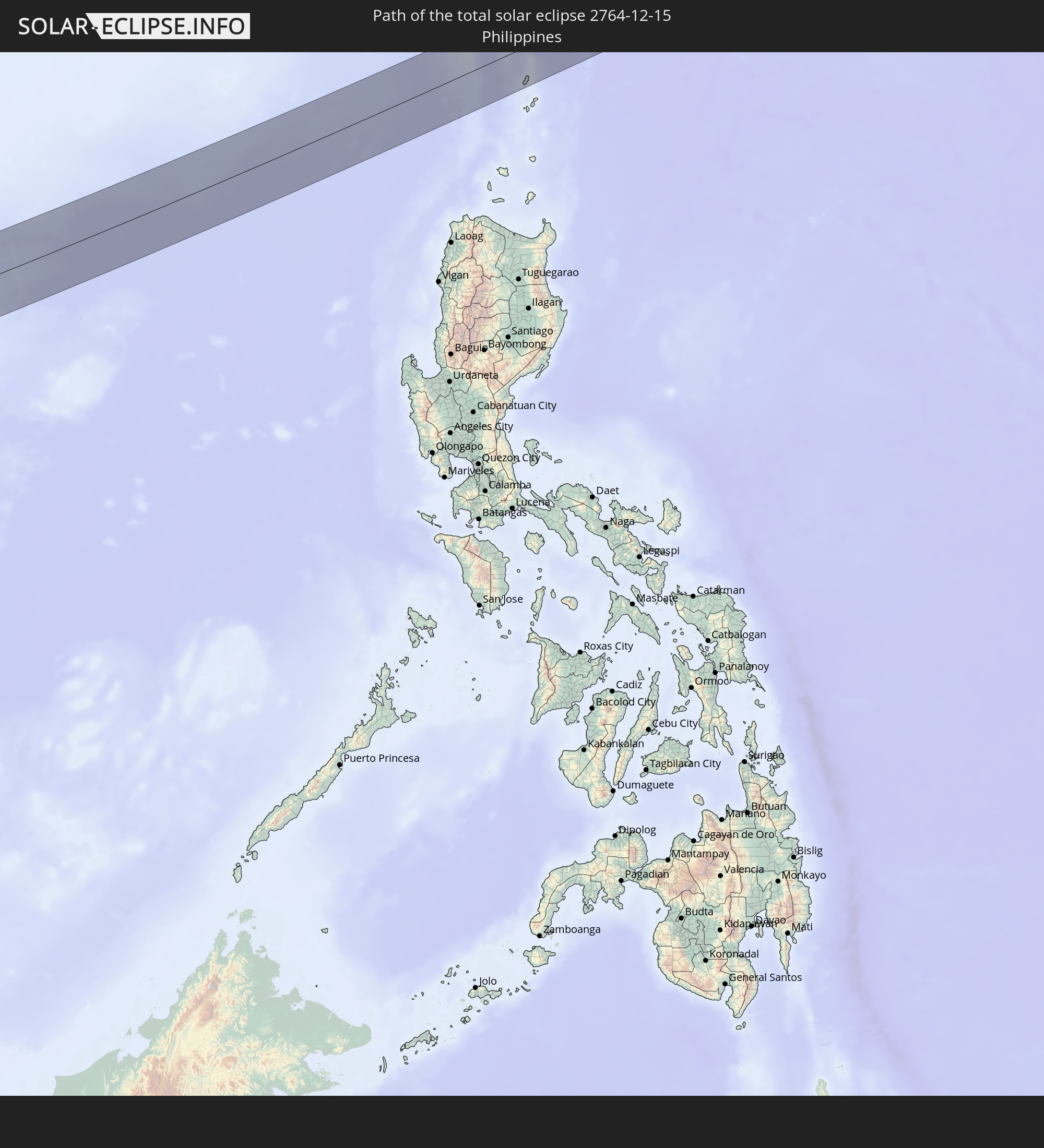 Philippinen
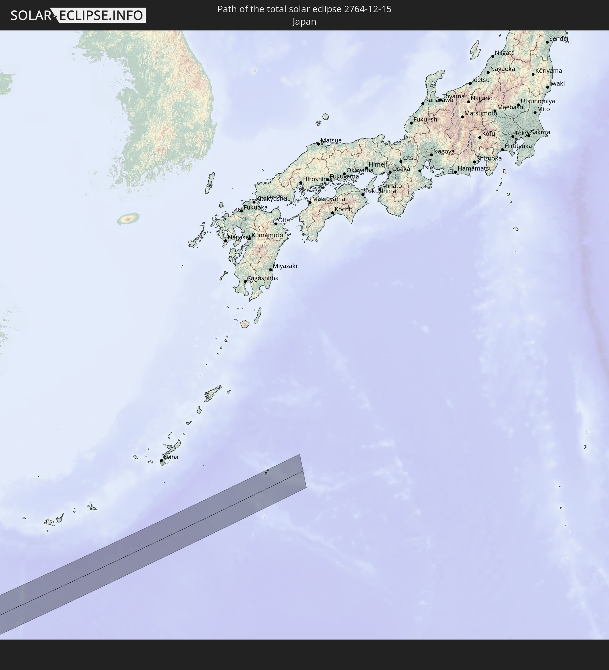 Japan
Japan
In den folgenden Ländern ist die Sonnenfinsternis partiell zu sehen
 Russland
 Nigeria
 Kamerun
 Libyen
 Demokratische Republik Kongo
 Tschad
 Zentralafrikanische Republik
 Griechenland
 Sudan
Sudan
 Ukraine
 Ägypten
 Türkei
 Uganda
 Republik Zypern
 Äthiopien
 Kenia
Kenia
 Staat Palästina
 Israel
 Saudi-Arabien
 Jordanien
 Libanon
 Syrien
 Eritrea
 Irak
Irak
 Georgien
 Somalia
 Dschibuti
 Jemen
Jemen
 Armenien
 Iran
Iran
 Aserbaidschan
 Seychellen
 Kasachstan
 Kuwait
 Bahrain
 Katar
Katar
 Vereinigte Arabische Emirate
 Oman
Oman
 Turkmenistan
 Usbekistan
 Mauritius
 Afghanistan
 Pakistan
 Tadschikistan
 Indien
 Kirgisistan
 Britisches Territorium im Indischen Ozean
 Malediven
 Volksrepublik China
 Sri Lanka
 Nepal
Nepal
 Mongolei
 Bangladesch
 Bhutan
 Myanmar
 Indonesien
 Kokosinseln
 Thailand
 Malaysia
 Laos
Laos
 Vietnam
 Kambodscha
 Singapur
 Weihnachtsinsel
 Australien
 Macau
Macau
 Hongkong
 Brunei
 Taiwan
 Philippinen
 Japan
Japan
 Osttimor
 Nordkorea
 Südkorea
 Palau
Palau
 Papua-Neuguinea
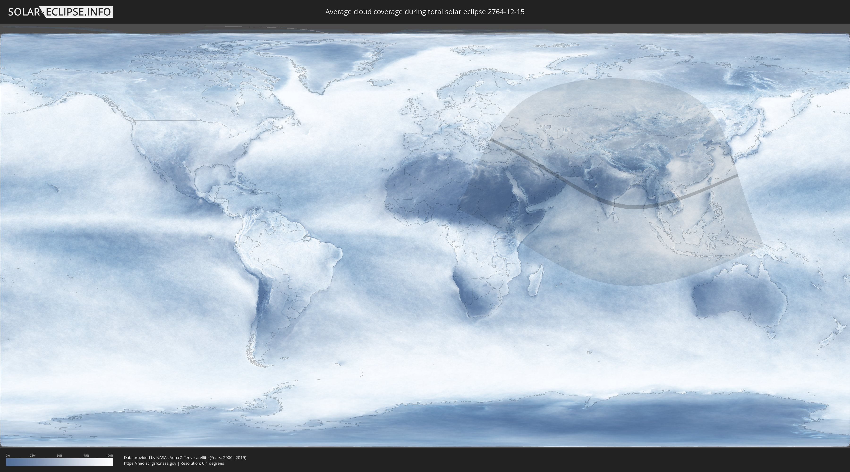
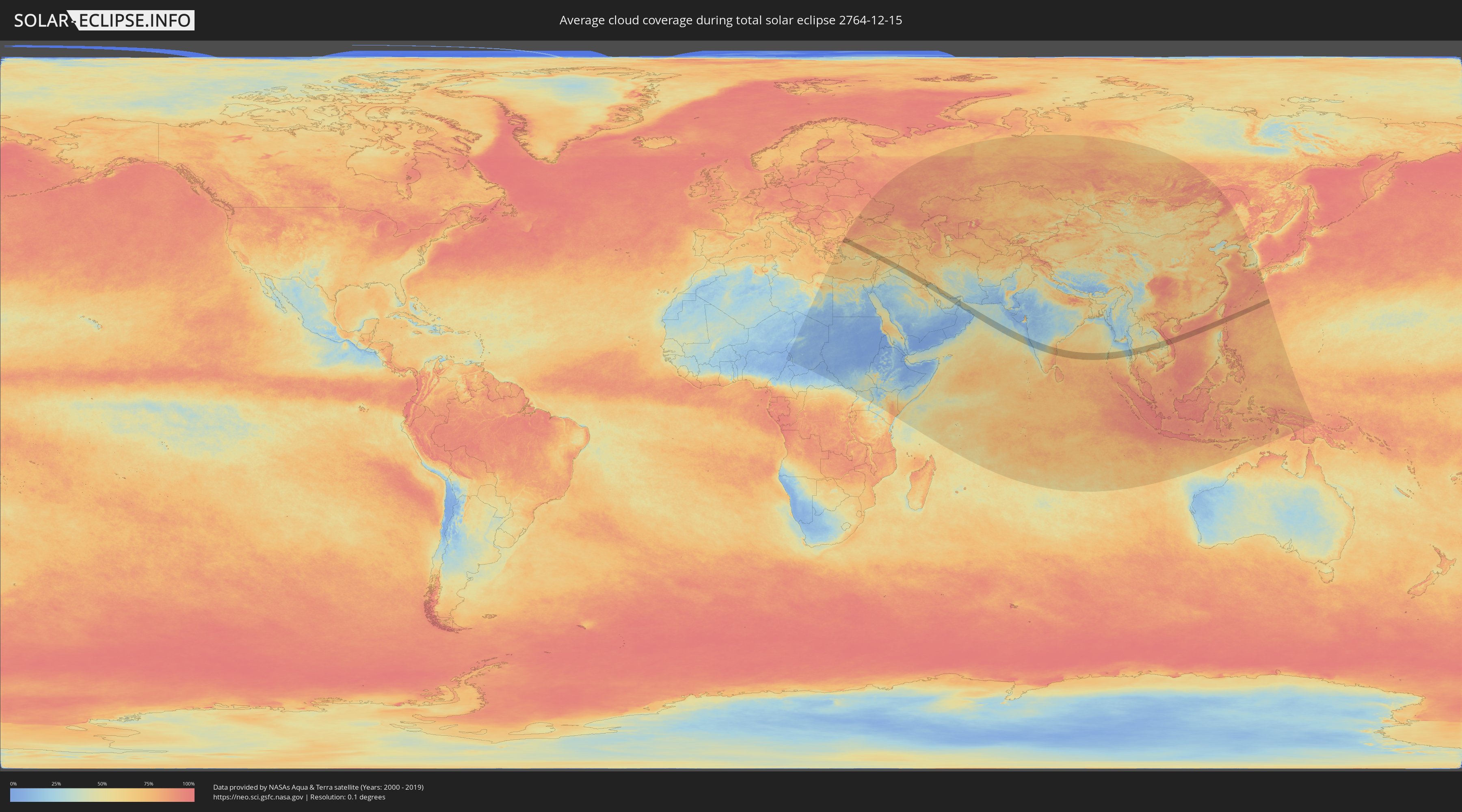
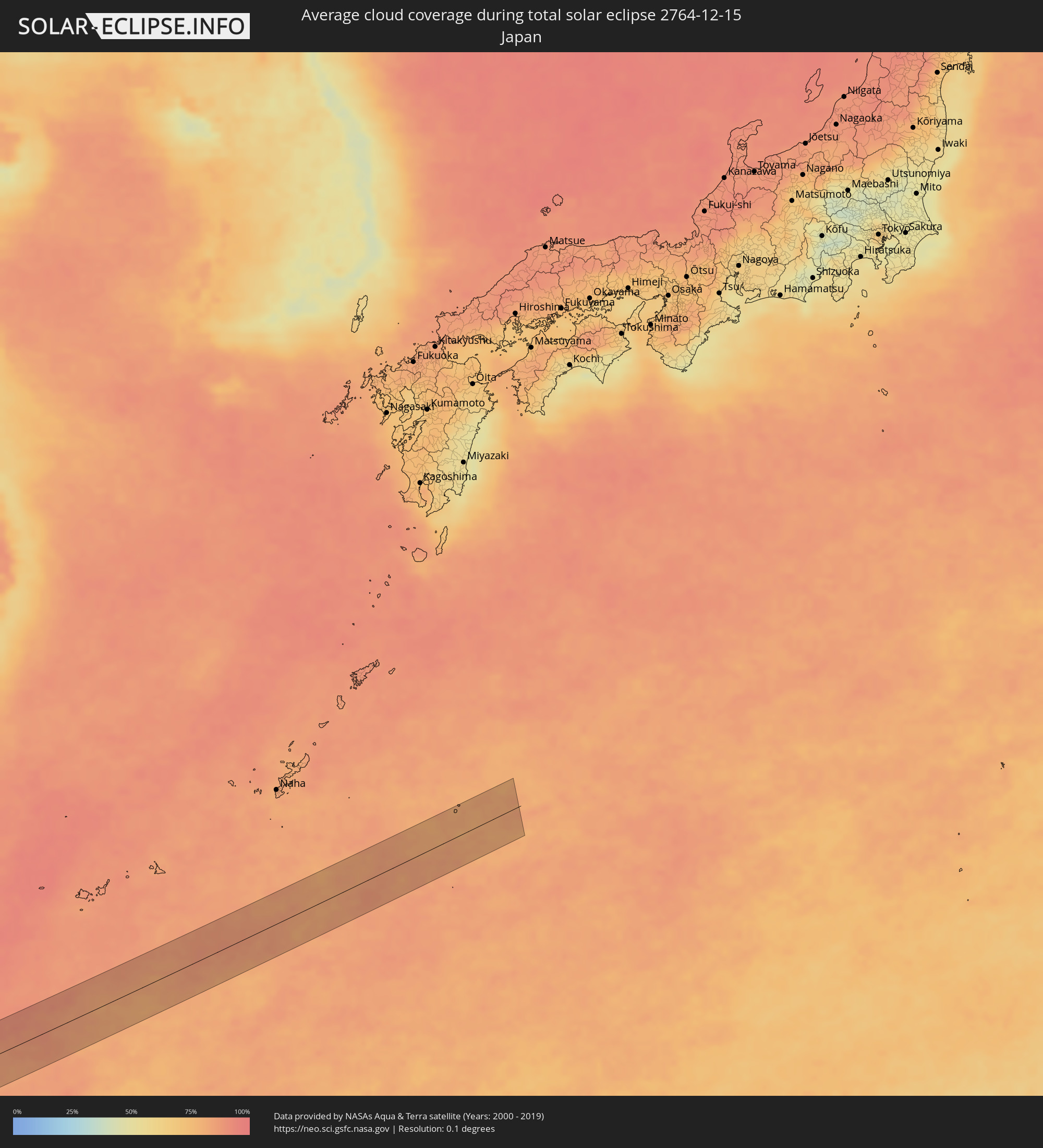
Wie wird das Wetter während der totalen Sonnenfinsternis am 15.12.2764?
Wo ist der beste Ort, um die totale Sonnenfinsternis vom 15.12.2764 zu beobachten?
Die folgenden Karten zeigen die durchschnittliche Bewölkung für den Tag, an dem die totale Sonnenfinsternis
stattfindet. Mit Hilfe der Karten lässt sich der Ort entlang des Finsternispfades eingrenzen,
der die besten Aussichen auf einen klaren wolkenfreien Himmel bietet.
Trotzdem muss man immer lokale Gegenenheiten beachten und sollte sich genau über das Wetter an seinem
gewählten Beobachtungsort informieren.
Die Daten stammen von den beiden NASA-Satelliten
AQUA und TERRA
und wurden über einen Zeitraum von 19 Jahren (2000 - 2019) gemittelt.
Detaillierte Länderkarten
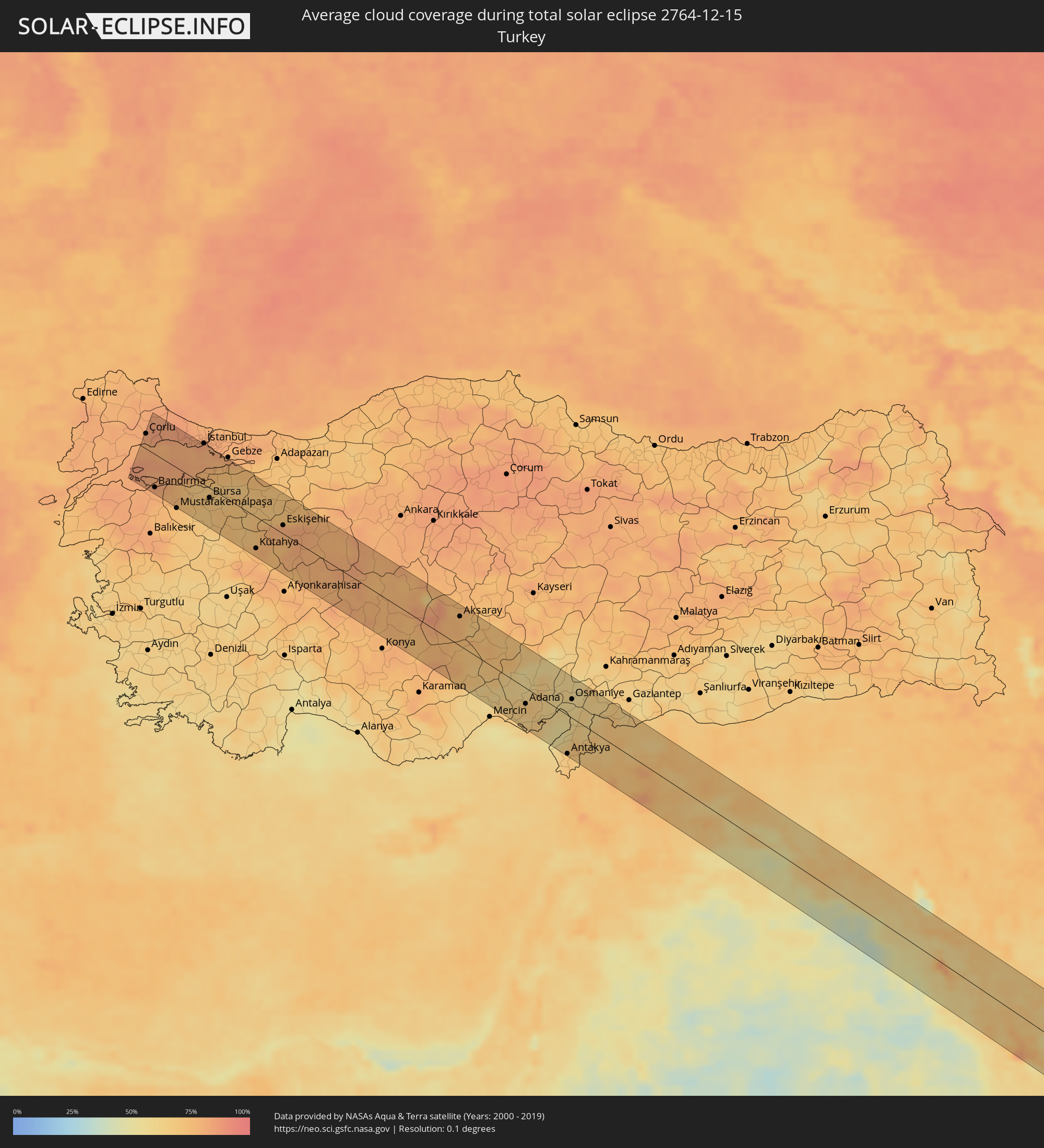 Türkei
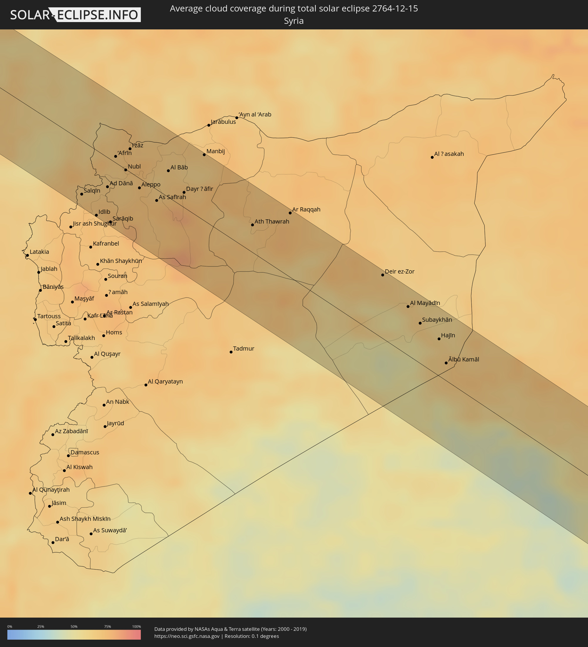 Syrien
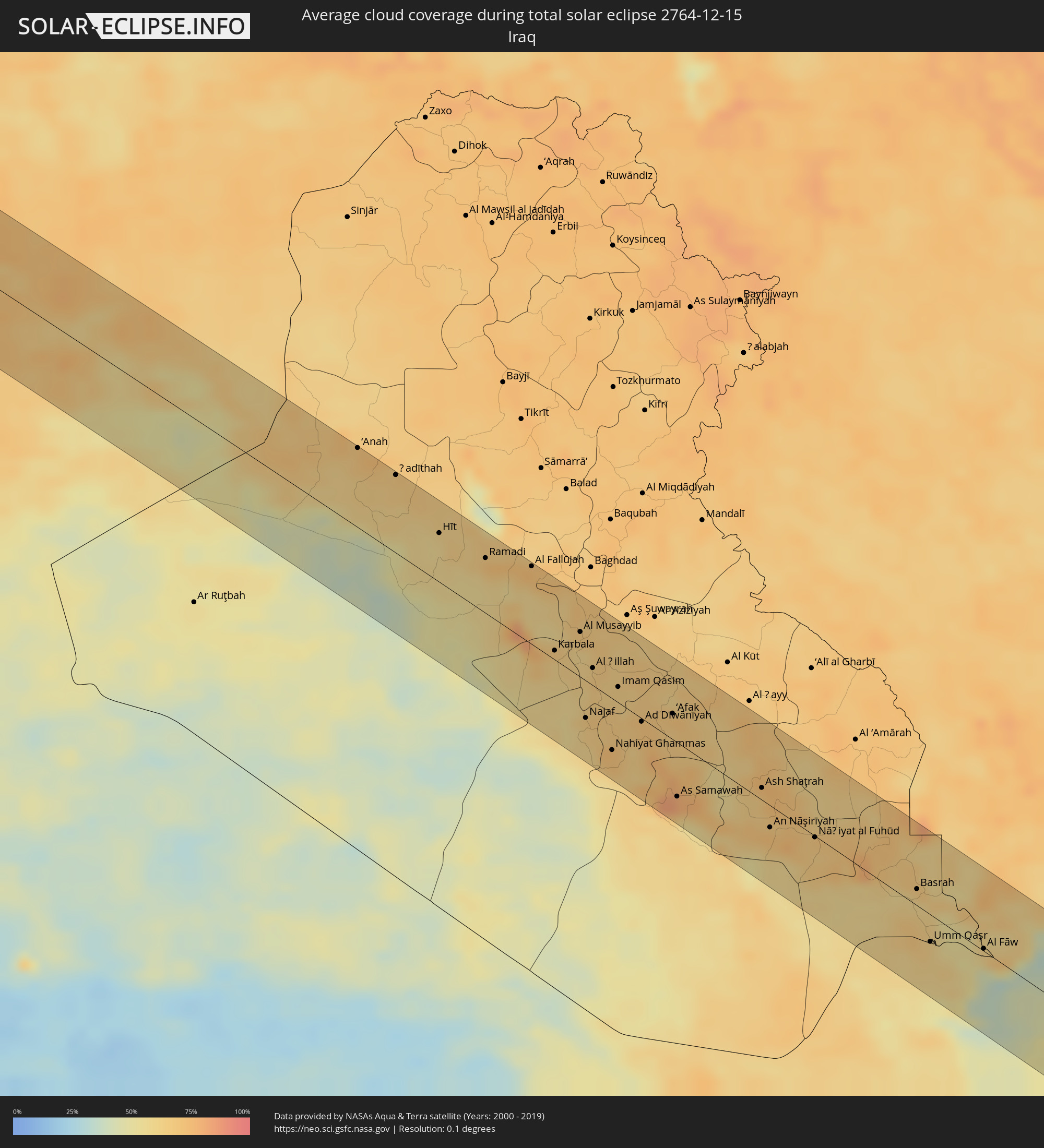 Irak
Irak
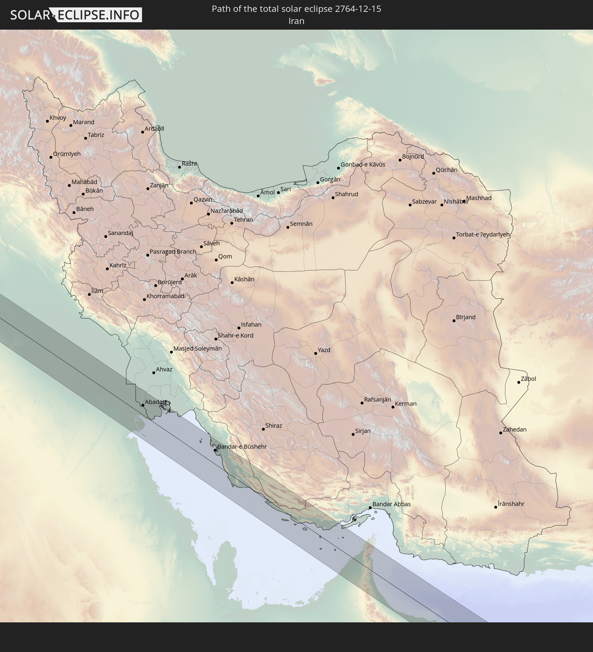
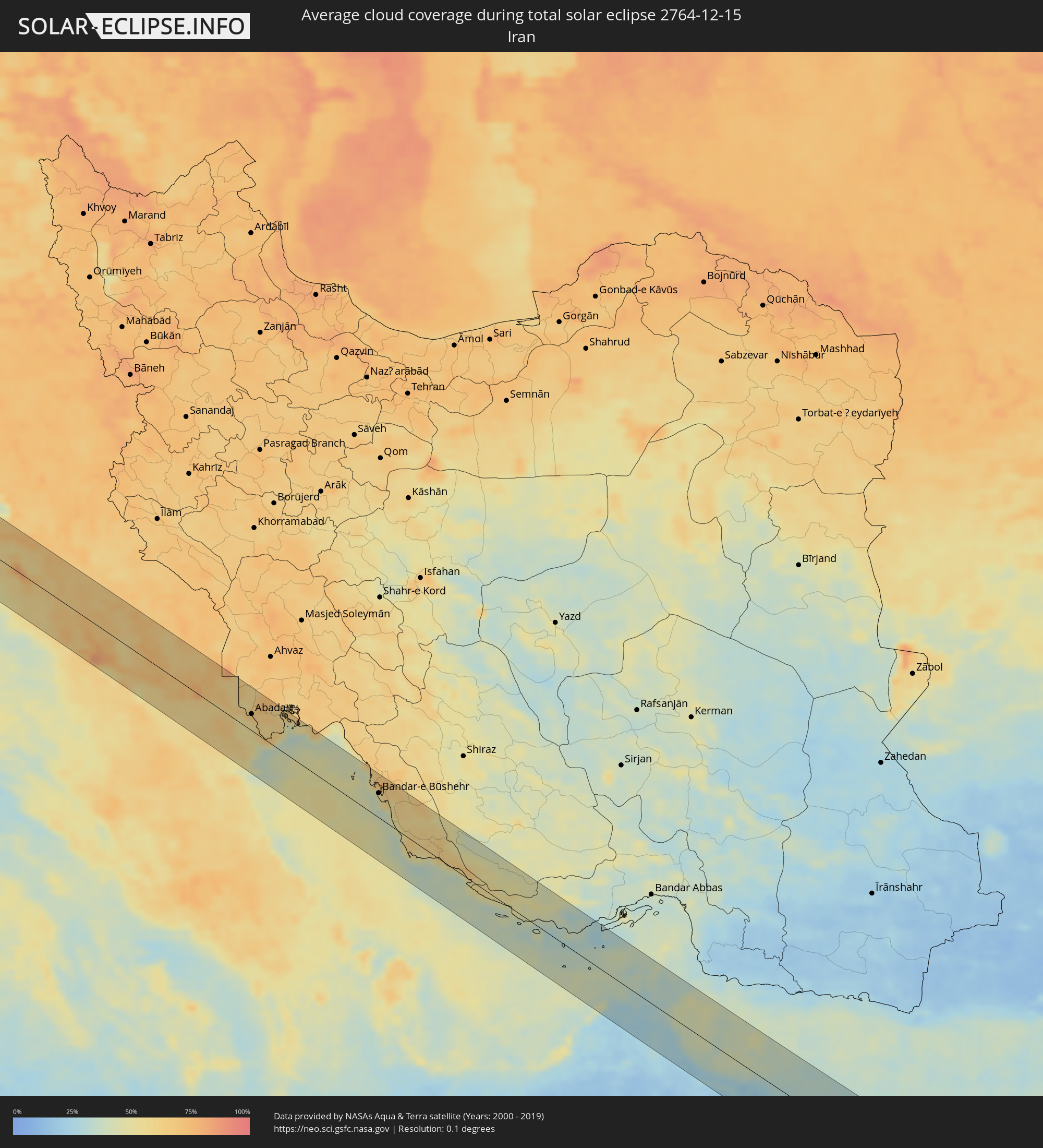 Iran
Iran
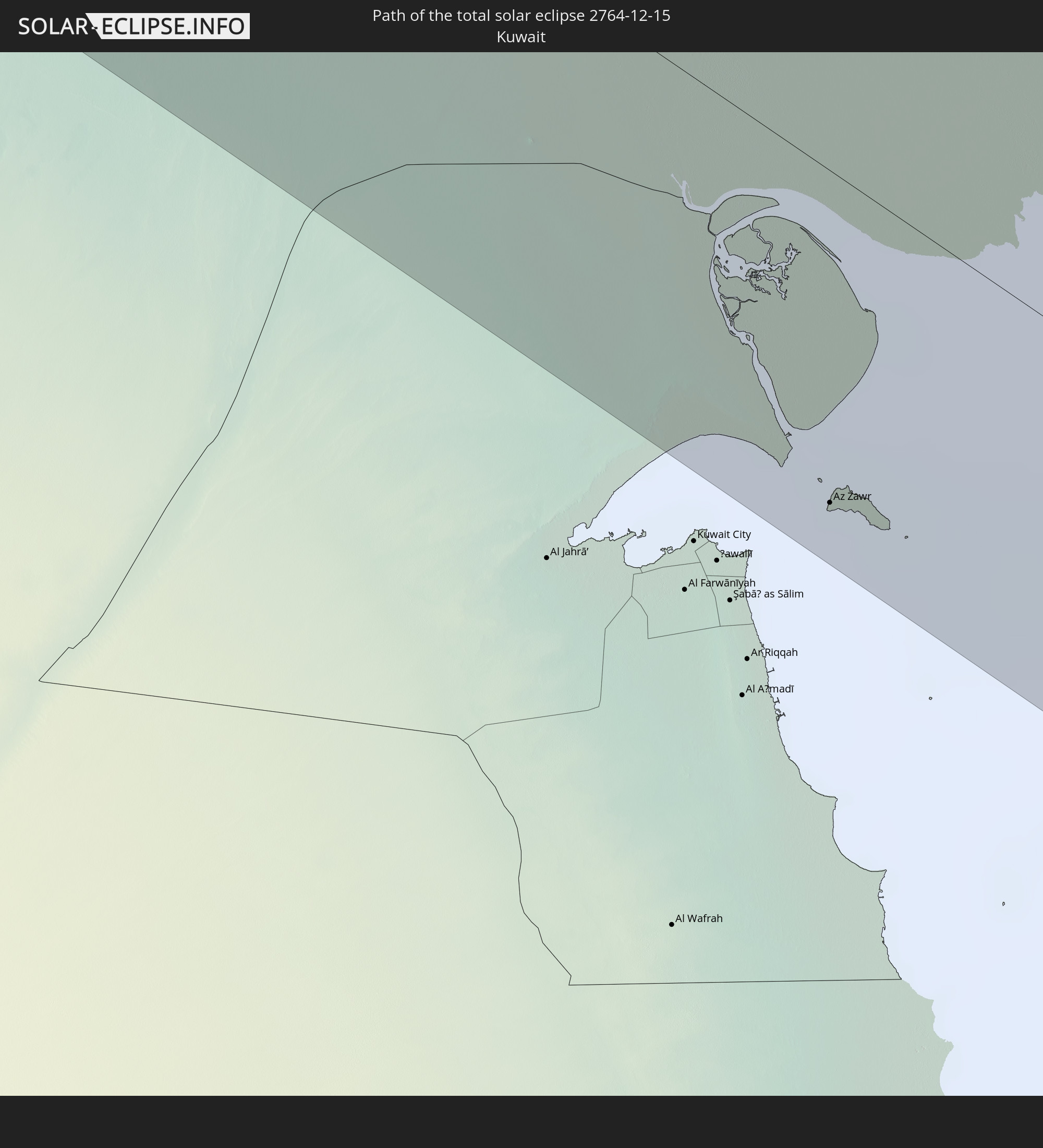
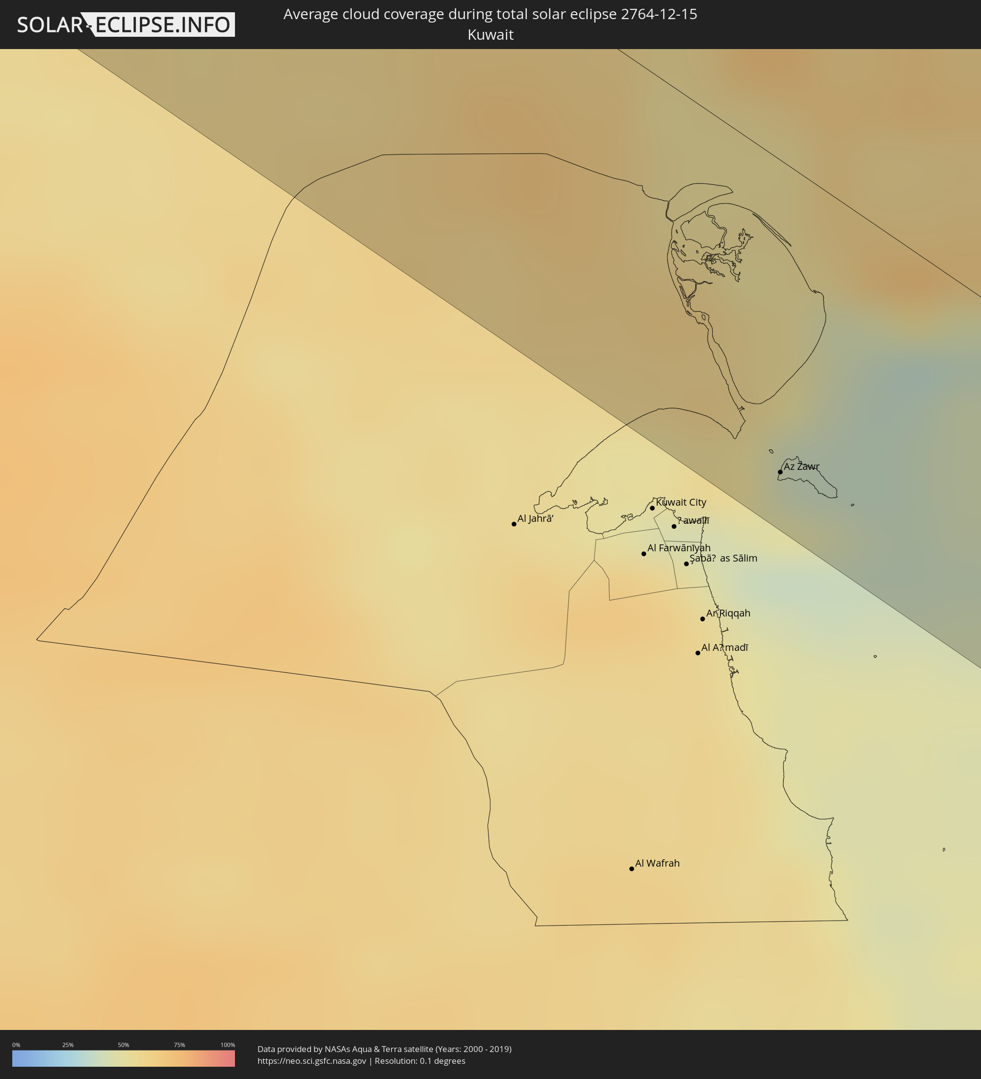 Kuwait
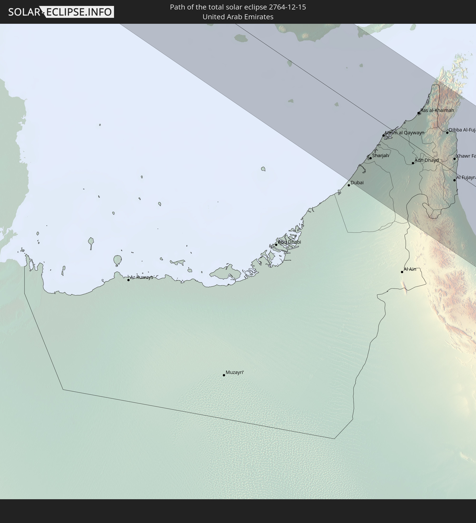
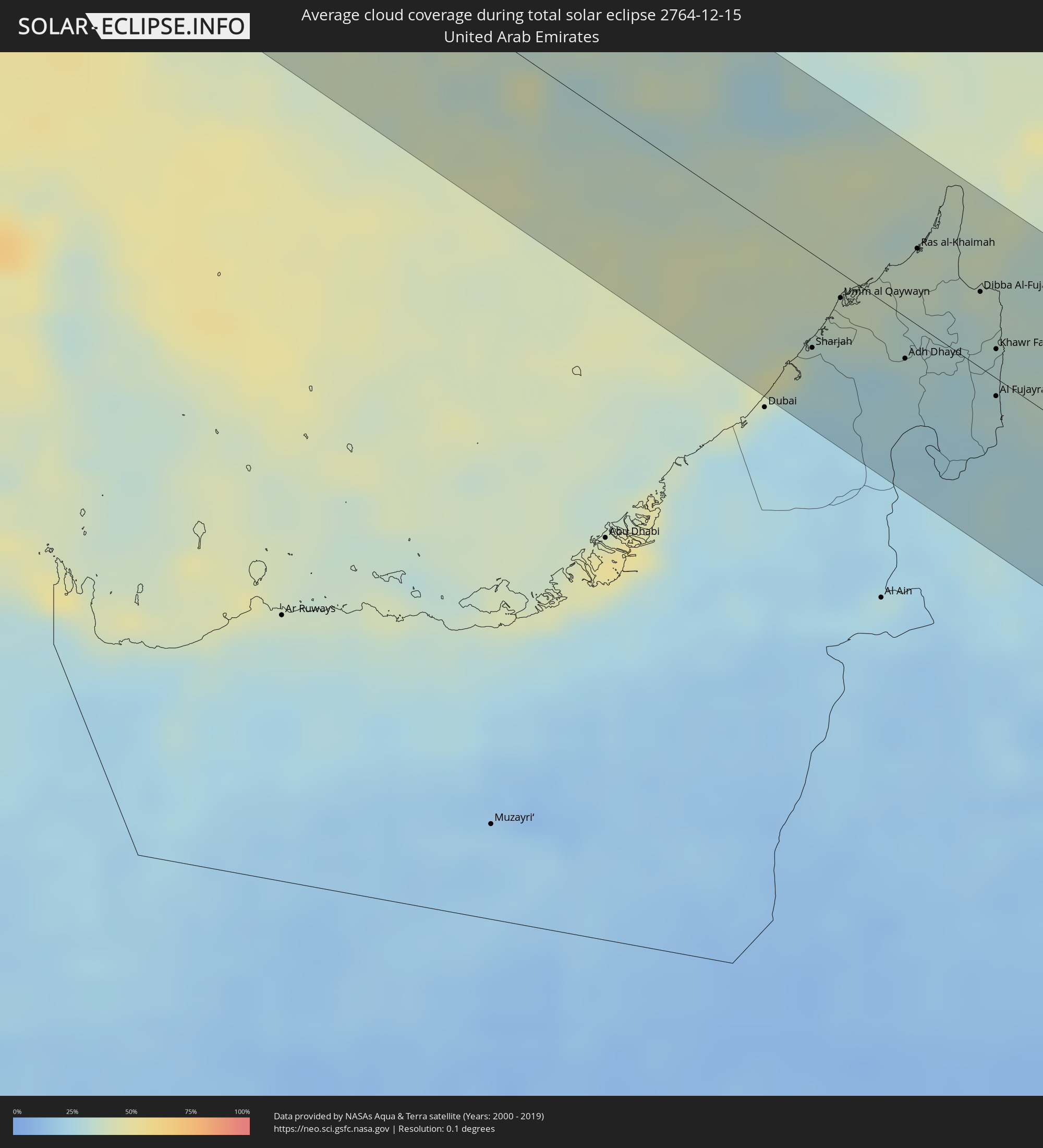 Vereinigte Arabische Emirate
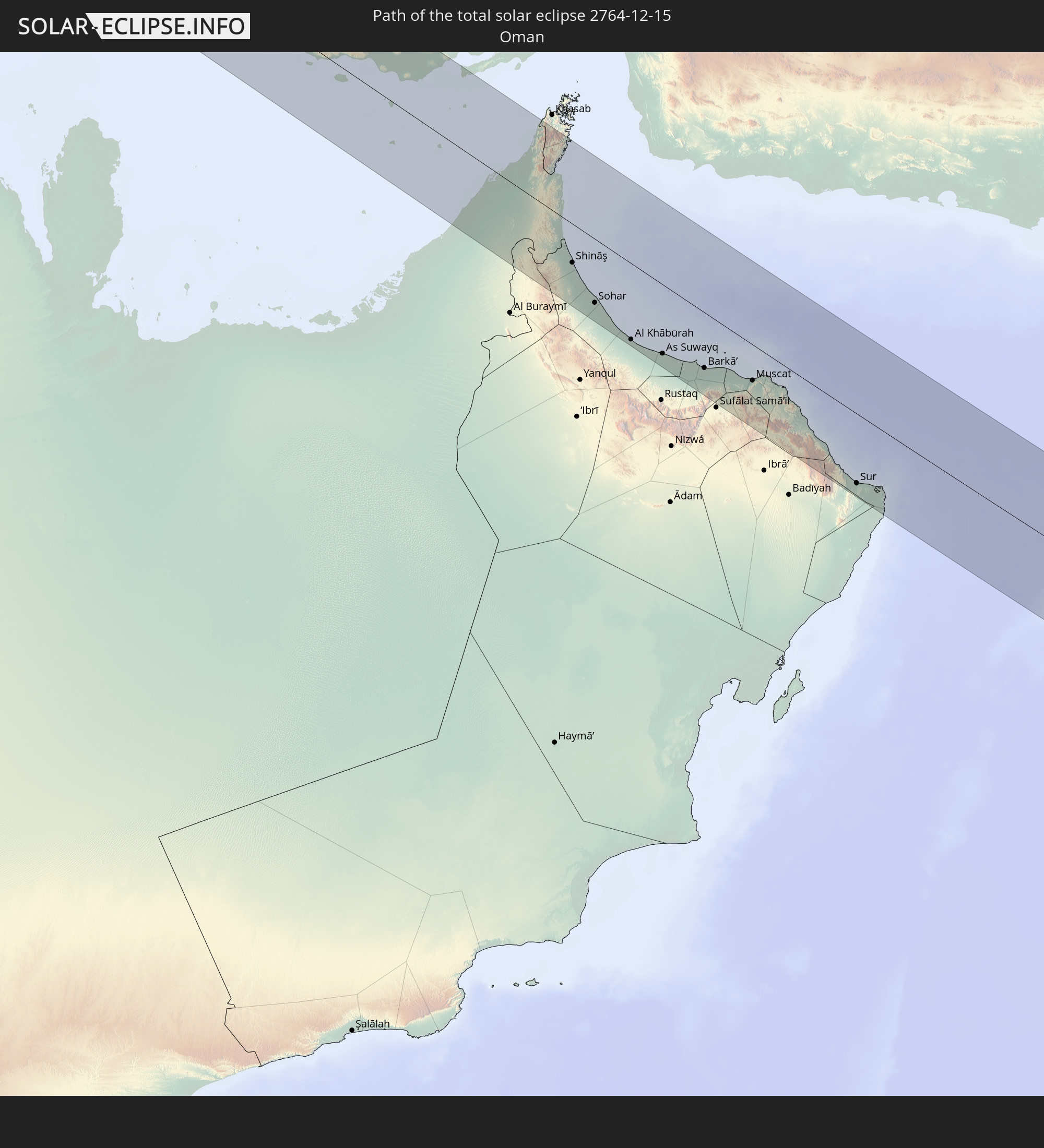
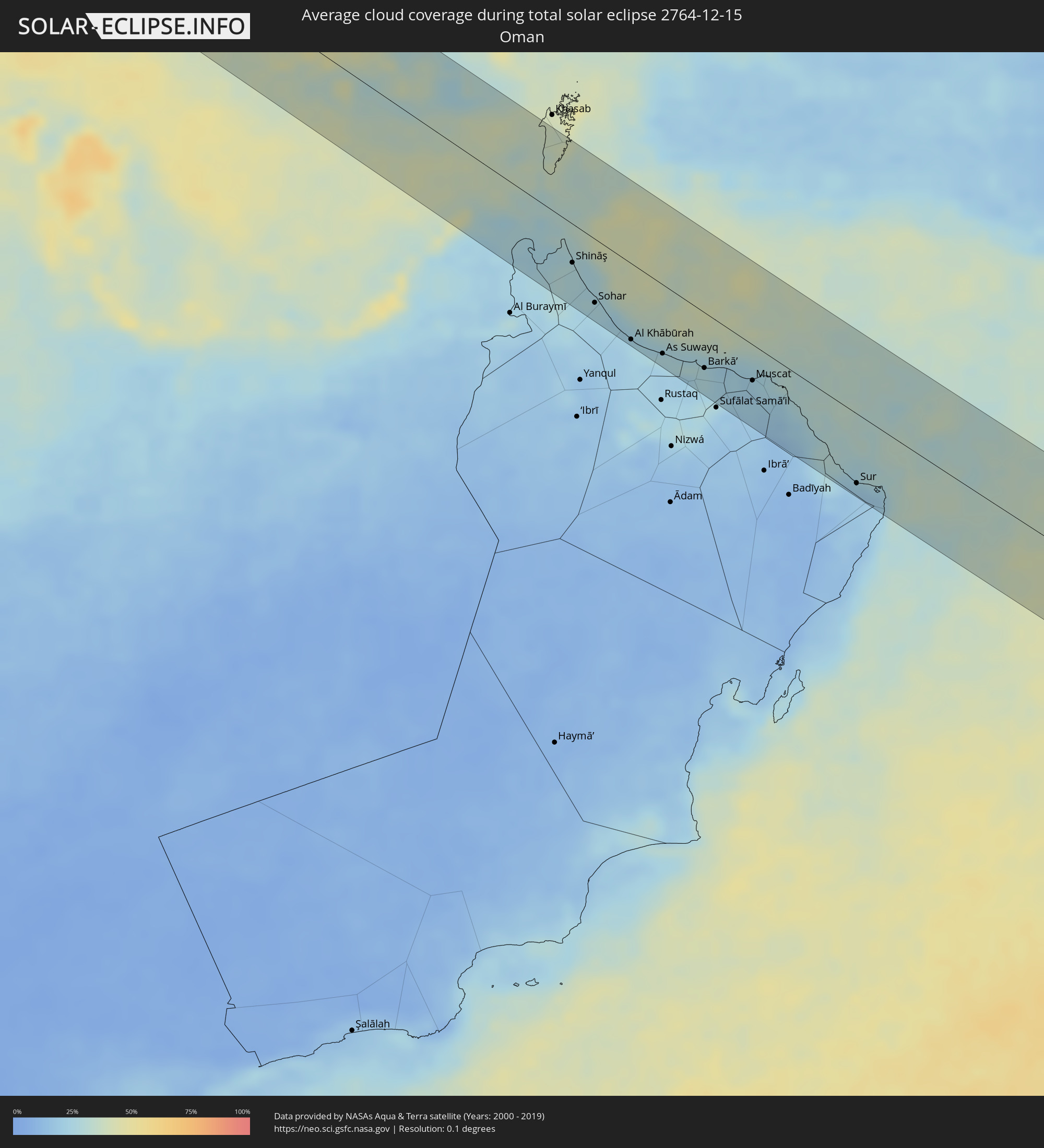 Oman
Oman
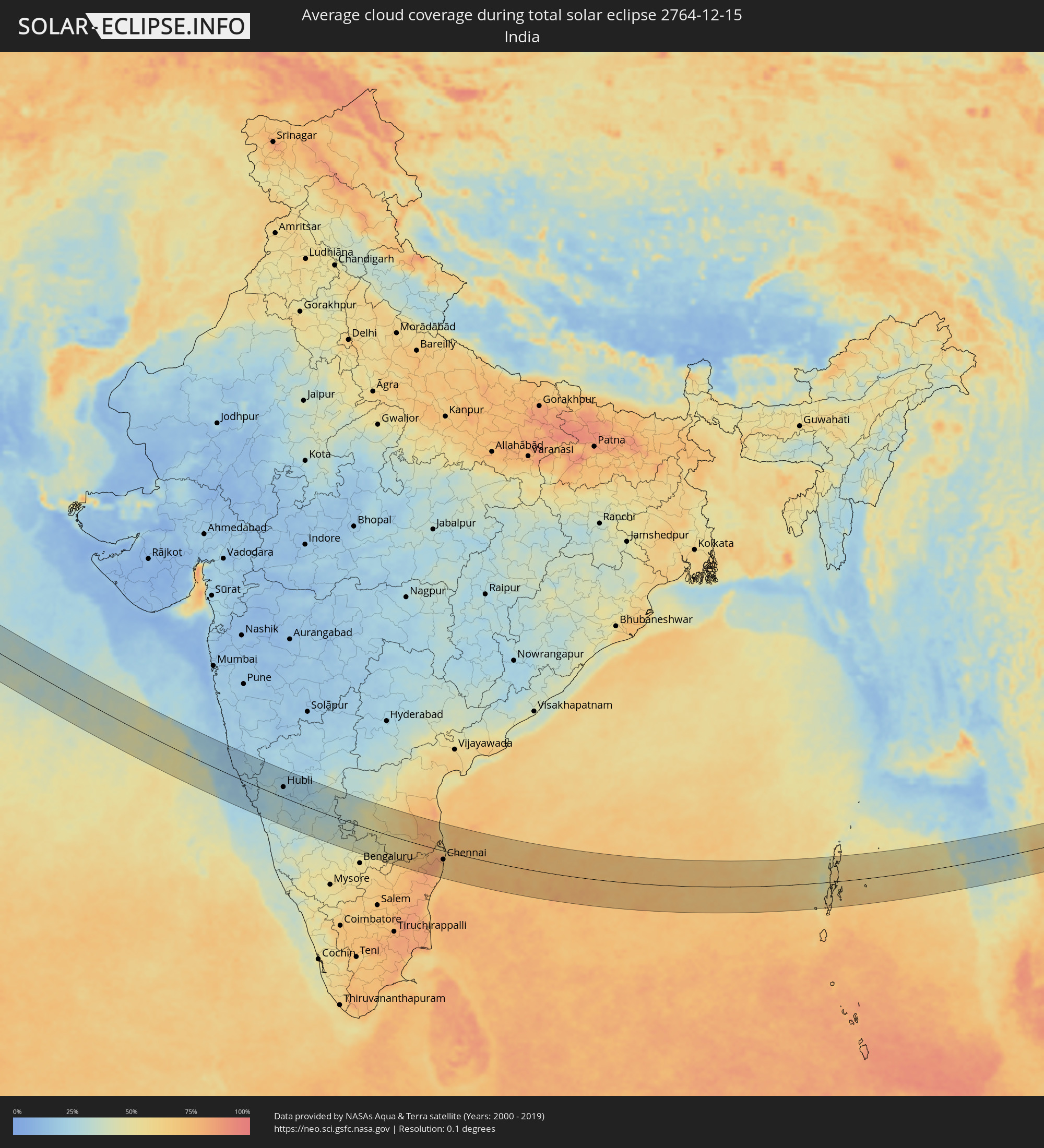 Indien
 Myanmar
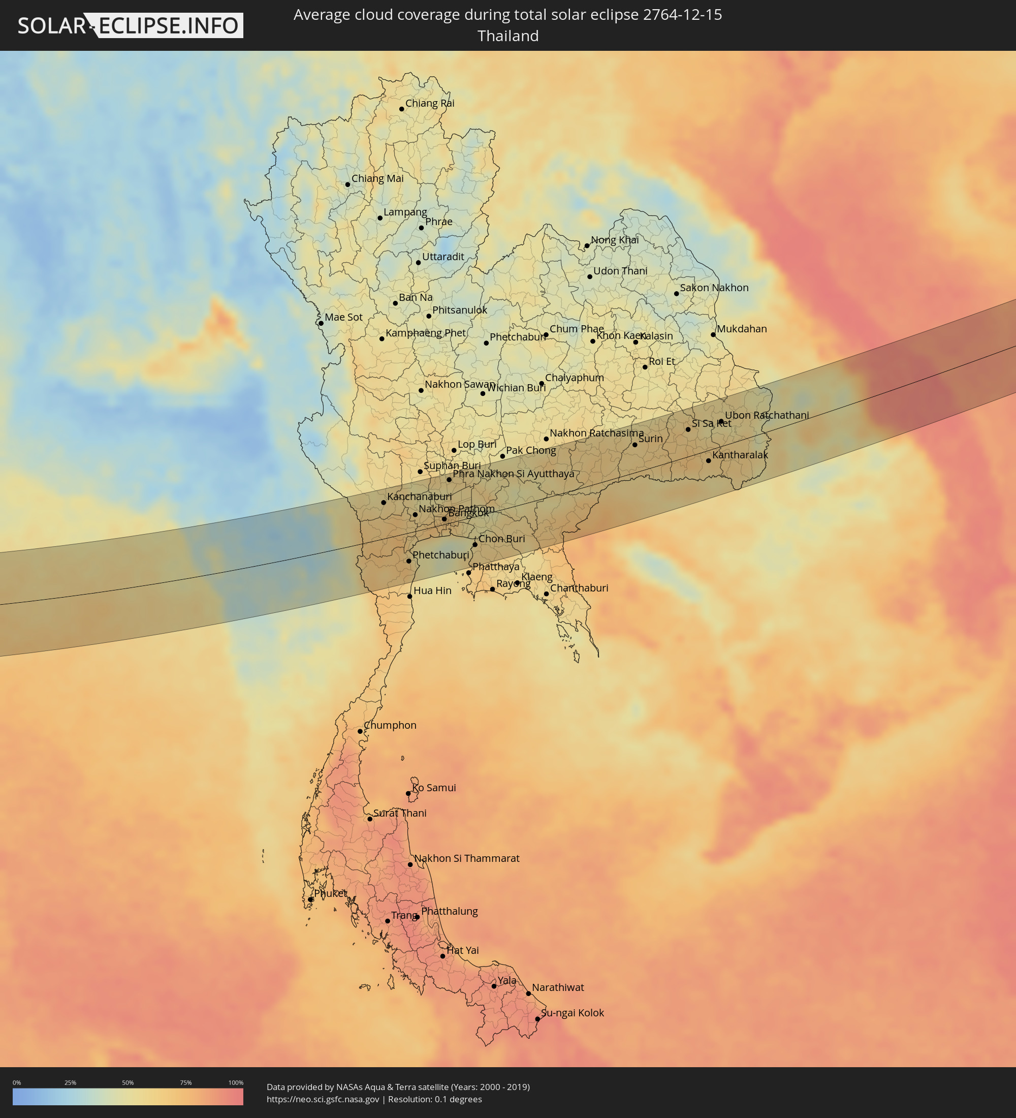 Thailand
 Laos
Laos
 Vietnam
 Kambodscha
 Philippinen
 Japan
Japan
Orte im Finsternispfad
Die nachfolgene Tabelle zeigt Städte und Orte mit mehr als 5.000 Einwohnern, die sich im Finsternispfad befinden. Städte mit mehr als 100.000 Einwohnern sind dick gekennzeichnet. Mit einem Klick auf den Ort öffnet sich eine Detailkarte die die Lage des jeweiligen Ortes zusammen mit dem Verlauf der zentralen Finsternis präsentiert.
| Ort | Typ | Dauer der Verfinsterung | Ortszeit bei maximaler Verfinsterung | Entfernung zur Zentrallinie | Ø Bewölkung |
|
Çorlu, Tekirdağ
|
total | - | 08:30:35 UTC+03:00 | 22 km | 82% |
|
Bandırma, Balıkesir
|
total | - | 08:30:01 UTC+03:00 | 47 km | 82% |
|
Esenyurt, Istanbul
|
total | - | 08:30:49 UTC+03:00 | 48 km | 79% |
|
Bağcılar, Istanbul
|
total | - | 08:30:54 UTC+03:00 | 57 km | 80% |
|
Bursa, Bursa
|
total | - | 08:30:20 UTC+03:00 | 14 km | 71% |
|
İnegol, Bursa
|
total | - | 08:30:26 UTC+03:00 | 5 km | 72% |
|
Kütahya, Kütahya
|
total | - | 08:30:08 UTC+03:00 | 45 km | 76% |
|
Eskişehir, Eskişehir
|
total | - | 08:30:38 UTC+03:00 | 12 km | 80% |
|
Aksaray, Aksaray
|
total | - | 08:31:24 UTC+03:00 | 43 km | 76% |
|
Ereğli, Konya
|
total | - | 08:30:51 UTC+03:00 | 37 km | 73% |
|
Niğde, Niğde
|
total | - | 08:31:30 UTC+03:00 | 36 km | 74% |
|
Tarsus, Mersin
|
total | - | 08:30:57 UTC+03:00 | 52 km | 65% |
|
Adana, Adana
|
total | - | 08:31:16 UTC+03:00 | 23 km | 67% |
|
Ceyhan, Adana
|
total | - | 08:31:35 UTC+03:00 | 2 km | 60% |
|
Antakya, Hatay
|
total | - | 08:31:18 UTC+03:00 | 58 km | 70% |
|
İskenderun, Hatay
|
total | - | 08:31:32 UTC+03:00 | 21 km | 61% |
|
Osmaniye, Osmaniye
|
total | - | 08:31:53 UTC+03:00 | 28 km | 58% |
|
Salqīn, Idlib
|
total | - | 07:31:27 UTC+02:00 | 49 km | 73% |
|
Idlib, Idlib
|
total | - | 07:31:27 UTC+02:00 | 60 km | 73% |
|
Ma‘arratmişrīn, Idlib
|
total | - | 07:31:31 UTC+02:00 | 51 km | 70% |
|
Binnish, Idlib
|
total | - | 07:31:31 UTC+02:00 | 54 km | 70% |
|
Sarāqib, Idlib
|
total | - | 07:31:31 UTC+02:00 | 58 km | 70% |
|
‘Afrīn, Aleppo
|
total | - | 07:31:57 UTC+02:00 | 6 km | 66% |
|
I‘zāz, Aleppo
|
total | - | 07:32:07 UTC+02:00 | 21 km | 71% |
|
Aleppo, Aleppo
|
total | - | 07:31:58 UTC+02:00 | 9 km | 72% |
|
As Safīrah, Aleppo
|
total | - | 07:32:02 UTC+02:00 | 10 km | 74% |
|
Al Bāb, Aleppo
|
total | - | 07:32:18 UTC+02:00 | 24 km | 66% |
|
Tādif, Aleppo
|
total | - | 07:32:18 UTC+02:00 | 23 km | 68% |
|
Manbij, Aleppo
|
total | - | 07:32:42 UTC+02:00 | 60 km | 63% |
|
Ath Thawrah, Ar-Raqqah
|
total | - | 07:32:43 UTC+02:00 | 25 km | 69% |
|
Ar Raqqah, Ar-Raqqah
|
total | - | 07:33:07 UTC+02:00 | 59 km | 71% |
|
Deir ez-Zor, Deir ez-Zor
|
total | - | 07:33:39 UTC+02:00 | 59 km | 65% |
|
Al Mayādīn, Deir ez-Zor
|
total | - | 07:33:43 UTC+02:00 | 45 km | 64% |
|
Ālbū Kamāl, Deir ez-Zor
|
total | - | 07:33:49 UTC+02:00 | 16 km | 65% |
|
Ramadi, Anbar
|
total | - | 08:35:24 UTC+03:00 | 44 km | 64% |
|
Al Fallūjah, Anbar
|
total | - | 08:35:49 UTC+03:00 | 62 km | 70% |
|
Karbala, Karbalāʼ
|
total | - | 08:35:44 UTC+03:00 | 7 km | 61% |
|
Al Hindīyah, Karbalāʼ
|
total | - | 08:35:54 UTC+03:00 | 12 km | 63% |
|
Al Musayyib, Bābil
|
total | - | 08:36:03 UTC+03:00 | 36 km | 67% |
|
Najaf, An Najaf
|
total | - | 08:35:49 UTC+03:00 | 30 km | 63% |
|
Al Ḩillah, Bābil
|
total | - | 08:36:03 UTC+03:00 | 14 km | 67% |
|
Ash Shāmīyah, Al Qādisīyah
|
total | - | 08:36:02 UTC+03:00 | 23 km | 67% |
|
Ad Dīwānīyah, Al Qādisīyah
|
total | - | 08:36:22 UTC+03:00 | 3 km | 70% |
|
Ar Rumaythah, Al Muthanná
|
total | - | 08:36:29 UTC+03:00 | 31 km | 78% |
|
As Samawah, Al Muthanná
|
total | - | 08:36:30 UTC+03:00 | 44 km | 63% |
|
Ash Shaţrah, Dhi Qar
|
total | - | 08:37:27 UTC+03:00 | 10 km | 72% |
|
An Nāşirīyah, Dhi Qar
|
total | - | 08:37:25 UTC+03:00 | 18 km | 70% |
|
Al Hārithah, Basra Governorate
|
total | - | 08:38:56 UTC+03:00 | 19 km | 67% |
|
Basrah, Basra Governorate
|
total | - | 08:38:56 UTC+03:00 | 13 km | 59% |
|
Umm Qaşr, Basra Governorate
|
total | - | 08:38:57 UTC+03:00 | 22 km | 61% |
|
Khorramshahr, Khuzestan
|
total | - | 09:09:22 UTC+03:30 | 29 km | 67% |
|
Az Zawr, Al Asimah
|
total | - | 08:39:13 UTC+03:00 | 58 km | 37% |
|
Abadan, Khuzestan
|
total | - | 09:09:29 UTC+03:30 | 26 km | 60% |
|
Al Fāw, Basra Governorate
|
total | - | 08:39:35 UTC+03:00 | 2 km | 65% |
|
Khārk, Bushehr
|
total | - | 09:11:41 UTC+03:30 | 38 km | 49% |
|
Bandar-e Būshehr, Bushehr
|
total | - | 09:12:16 UTC+03:30 | 39 km | 52% |
|
Kīsh, Hormozgan
|
total | - | 09:16:24 UTC+03:30 | 5 km | 42% |
|
Bandar-e Lengeh, Hormozgan
|
total | - | 09:17:42 UTC+03:30 | 43 km | 35% |
|
Sharjah, Ash Shāriqah
|
total | - | 09:48:30 UTC+04:00 | 39 km | 30% |
|
Ajman, Ajman
|
total | - | 09:48:33 UTC+04:00 | 31 km | 32% |
|
Umm al Qaywayn, Umm al Qaywayn
|
total | - | 09:48:44 UTC+04:00 | 10 km | 39% |
|
Adh Dhayd, Ash Shāriqah
|
total | - | 09:49:15 UTC+04:00 | 18 km | 29% |
|
Ras al-Khaimah, Raʼs al Khaymah
|
total | - | 09:49:21 UTC+04:00 | 32 km | 38% |
|
Dibba Al-Fujairah, Al Fujayrah
|
total | - | 09:49:52 UTC+04:00 | 32 km | 34% |
|
Dibba Al-Hisn, Al Fujayrah
|
total | - | 09:49:53 UTC+04:00 | 35 km | 34% |
|
Al Fujayrah, Al Fujayrah
|
total | - | 09:50:00 UTC+04:00 | 8 km | 31% |
|
Khawr Fakkān, Ash Shāriqah
|
total | - | 09:50:00 UTC+04:00 | 12 km | 31% |
|
Shināş, Al Batinah North Governorate
|
total | - | 09:50:13 UTC+04:00 | 35 km | 27% |
|
Al Liwā’, Al Batinah North Governorate
|
total | - | 09:50:24 UTC+04:00 | 48 km | 28% |
|
Sohar, Al Batinah North Governorate
|
total | - | 09:50:39 UTC+04:00 | 58 km | 26% |
|
Şaḩam, Al Batinah North Governorate
|
total | - | 09:50:58 UTC+04:00 | 64 km | 24% |
|
Al Khābūrah, Al Batinah North Governorate
|
total | - | 09:51:20 UTC+04:00 | 69 km | 25% |
|
As Suwayq, Al Batinah North Governorate
|
total | - | 09:51:55 UTC+04:00 | 63 km | 23% |
|
Barkā’, Al Batinah South Governorate
|
total | - | 09:52:43 UTC+04:00 | 51 km | 27% |
|
Bidbid, Muḩāfaz̧at ad Dākhilīyah
|
total | - | 09:53:10 UTC+04:00 | 65 km | 17% |
|
Seeb, Muḩāfaz̧at Masqaţ
|
total | - | 09:53:15 UTC+04:00 | 37 km | 24% |
|
Bawshar, Muḩāfaz̧at Masqaţ
|
total | - | 09:53:38 UTC+04:00 | 36 km | 21% |
|
Muscat, Muḩāfaz̧at Masqaţ
|
total | - | 09:53:39 UTC+04:00 | 33 km | 21% |
|
Sur, Ash Sharqiyah South Governorate
|
total | - | 09:55:50 UTC+04:00 | 64 km | 20% |
|
Belgaum, Karnataka
|
total | - | 12:03:51 UTC+05:30 | 59 km | 22% |
|
Hubli, Karnataka
|
total | - | 12:05:57 UTC+05:30 | 33 km | 26% |
|
Gadag, Karnataka
|
total | - | 12:07:19 UTC+05:30 | 62 km | 21% |
|
Hospet, Karnataka
|
total | - | 12:09:36 UTC+05:30 | 74 km | 29% |
|
Chitradurga, Karnataka
|
total | - | 12:10:18 UTC+05:30 | 34 km | 35% |
|
Bellary, Karnataka
|
total | - | 12:11:15 UTC+05:30 | 81 km | 31% |
|
Hindupur, Andhra Pradesh
|
total | - | 12:13:46 UTC+05:30 | 36 km | 40% |
|
Anantapur, Andhra Pradesh
|
total | - | 12:13:33 UTC+05:30 | 57 km | 41% |
|
Dharmavaram, Andhra Pradesh
|
total | - | 12:14:03 UTC+05:30 | 33 km | 45% |
|
Kolār, Karnataka
|
total | - | 12:16:06 UTC+05:30 | 88 km | 58% |
|
Cuddapah, Andhra Pradesh
|
total | - | 12:17:18 UTC+05:30 | 77 km | 57% |
|
Vellore, Tamil Nadu
|
total | - | 12:19:14 UTC+05:30 | 80 km | 73% |
|
Tirupati, Andhra Pradesh
|
total | - | 12:19:37 UTC+05:30 | 5 km | 70% |
|
Kānchipuram, Tamil Nadu
|
total | - | 12:20:59 UTC+05:30 | 73 km | 82% |
|
Āvadi, Tamil Nadu
|
total | - | 12:22:02 UTC+05:30 | 31 km | 82% |
|
Pallāvaram, Tamil Nadu
|
total | - | 12:22:15 UTC+05:30 | 46 km | 73% |
|
Chennai, Tamil Nadu
|
total | - | 12:22:34 UTC+05:30 | 29 km | 68% |
|
Kanchanaburi, Kanchanaburi
|
total | - | 14:45:03 UTC+07:00 | 59 km | 56% |
|
Tha Maka, Kanchanaburi
|
total | - | 14:45:35 UTC+07:00 | 42 km | 67% |
|
Ratchaburi, Ratchaburi
|
total | - | 14:45:54 UTC+07:00 | 1 km | 73% |
|
Ban Pong, Ratchaburi
|
total | - | 14:45:52 UTC+07:00 | 30 km | 63% |
|
Nakhon Pathom, Nakhon Pathom
|
total | - | 14:46:14 UTC+07:00 | 26 km | 61% |
|
Krathum Baen, Samut Sakhon
|
total | - | 14:46:47 UTC+07:00 | 3 km | 71% |
|
Pak Kret, Nonthaburi
|
total | - | 14:47:10 UTC+07:00 | 25 km | 67% |
|
Bangkok, Bangkok
|
total | - | 14:47:15 UTC+07:00 | 8 km | 67% |
|
Phra Nakhon Si Ayutthaya, Phra Nakhon Si Ayutthaya
|
total | - | 14:47:05 UTC+07:00 | 70 km | 58% |
|
Samut Prakan, Samut Prakan
|
total | - | 14:47:32 UTC+07:00 | 12 km | 57% |
|
Khlong Luang, Pathum Thani
|
total | - | 14:47:23 UTC+07:00 | 37 km | 61% |
|
Ban Lam Luk Ka, Pathum Thani
|
total | - | 14:47:43 UTC+07:00 | 24 km | 57% |
|
Saraburi, Sara Buri
|
total | - | 14:47:42 UTC+07:00 | 81 km | 58% |
|
Si Racha, Chon Buri
|
total | - | 14:48:29 UTC+07:00 | 66 km | 61% |
|
Chon Buri, Chon Buri
|
total | - | 14:48:29 UTC+07:00 | 47 km | 58% |
|
Chachoengsao, Chachoengsao
|
total | - | 14:48:30 UTC+07:00 | 15 km | 50% |
|
Paôy Pêt, Banteay Meanchey
|
total | - | 14:51:33 UTC+07:00 | 60 km | 74% |
|
Sisŏphŏn, Banteay Meanchey
|
total | - | 14:52:24 UTC+07:00 | 79 km | 78% |
|
Sâmraông, Ŏtâr Méanchey
|
total | - | 14:53:07 UTC+07:00 | 32 km | 61% |
|
Ubon Ratchathani, Changwat Ubon Ratchathani
|
total | - | 14:55:01 UTC+07:00 | 39 km | 55% |
|
Pakse, Champasak
|
total | - | 14:56:47 UTC+07:00 | 5 km | 55% |
|
Champasak, Champasak
|
total | - | 14:57:03 UTC+07:00 | 31 km | 51% |
|
Salavan, Salavan
|
total | - | 14:57:31 UTC+07:00 | 38 km | 53% |
|
Lamam, Xékong
|
total | - | 14:58:10 UTC+07:00 | 3 km | 54% |
|
Attapu, Attapu
|
total | - | 14:58:44 UTC+07:00 | 72 km | 47% |
|
Da Nang, Đà Nẵng
|
total | - | 15:00:18 UTC+07:00 | 12 km | 92% |
|
Hội An, Quảng Nam
|
total | - | 15:00:35 UTC+07:00 | 12 km | 93% |
|
Tam Kỳ, Quảng Nam
|
total | - | 15:00:59 UTC+07:00 | 49 km | 91% |