Totale Sonnenfinsternis vom 29.04.2777
| Wochentag: | Freitag |
| Maximale Dauer der Verfinsterung: | 05m00s |
| Maximale Breite des Finsternispfades: | 307 km |
| Saroszyklus: | 170 |
| Bedeckungsgrad: | 100% |
| Magnitude: | 1.0607 |
| Gamma: | -0.7632 |
Wo kann man die Sonnenfinsternis vom 29.04.2777 sehen?
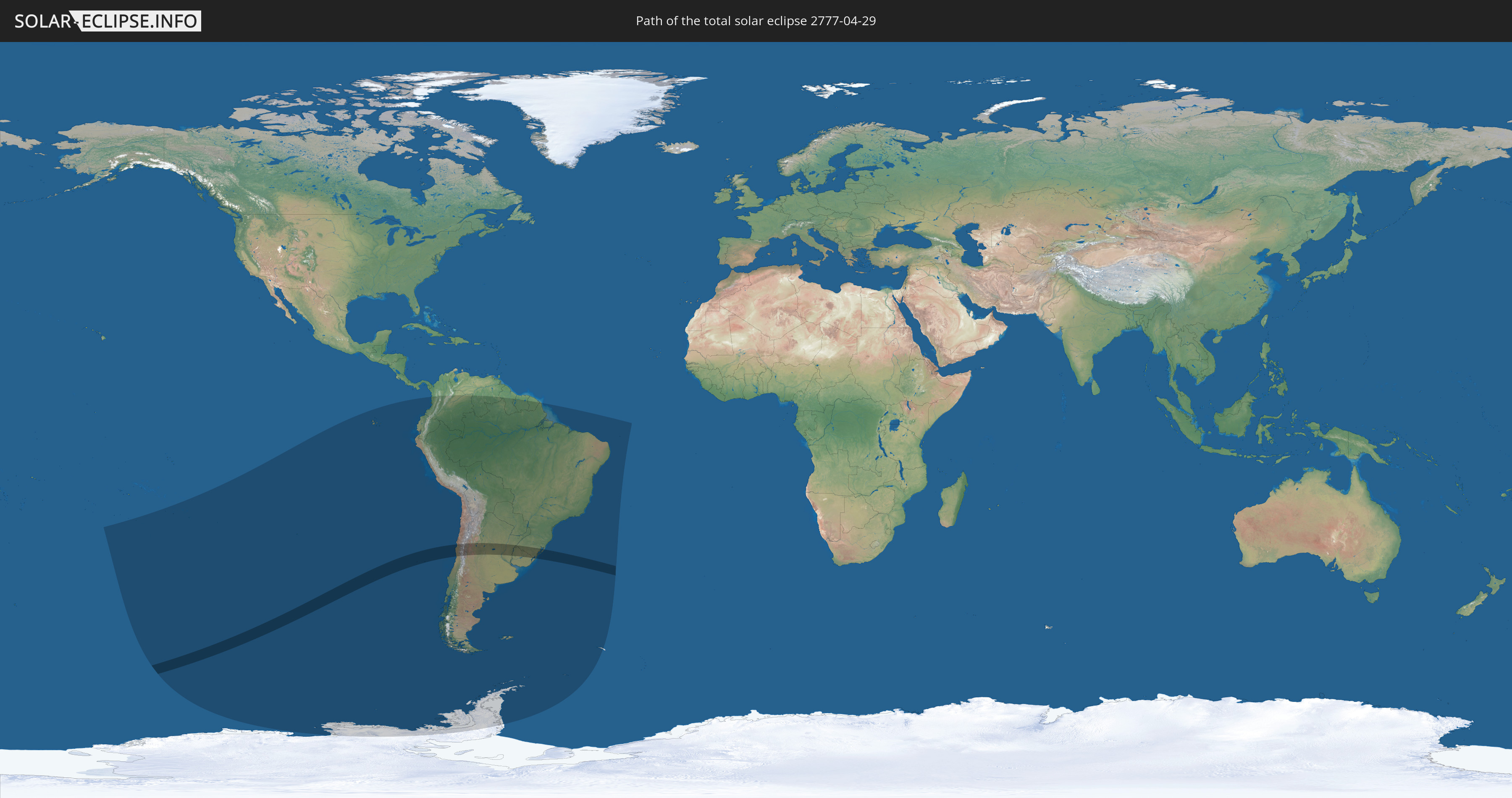
Die Sonnenfinsternis am 29.04.2777 kann man in 18 Ländern als partielle Sonnenfinsternis beobachten.
Der Finsternispfad verläuft durch 4 Länder. Nur in diesen Ländern ist sie als totale Sonnenfinsternis zu sehen.
In den folgenden Ländern ist die Sonnenfinsternis total zu sehen
 Chile
Chile
 Brasilien
 Argentinien
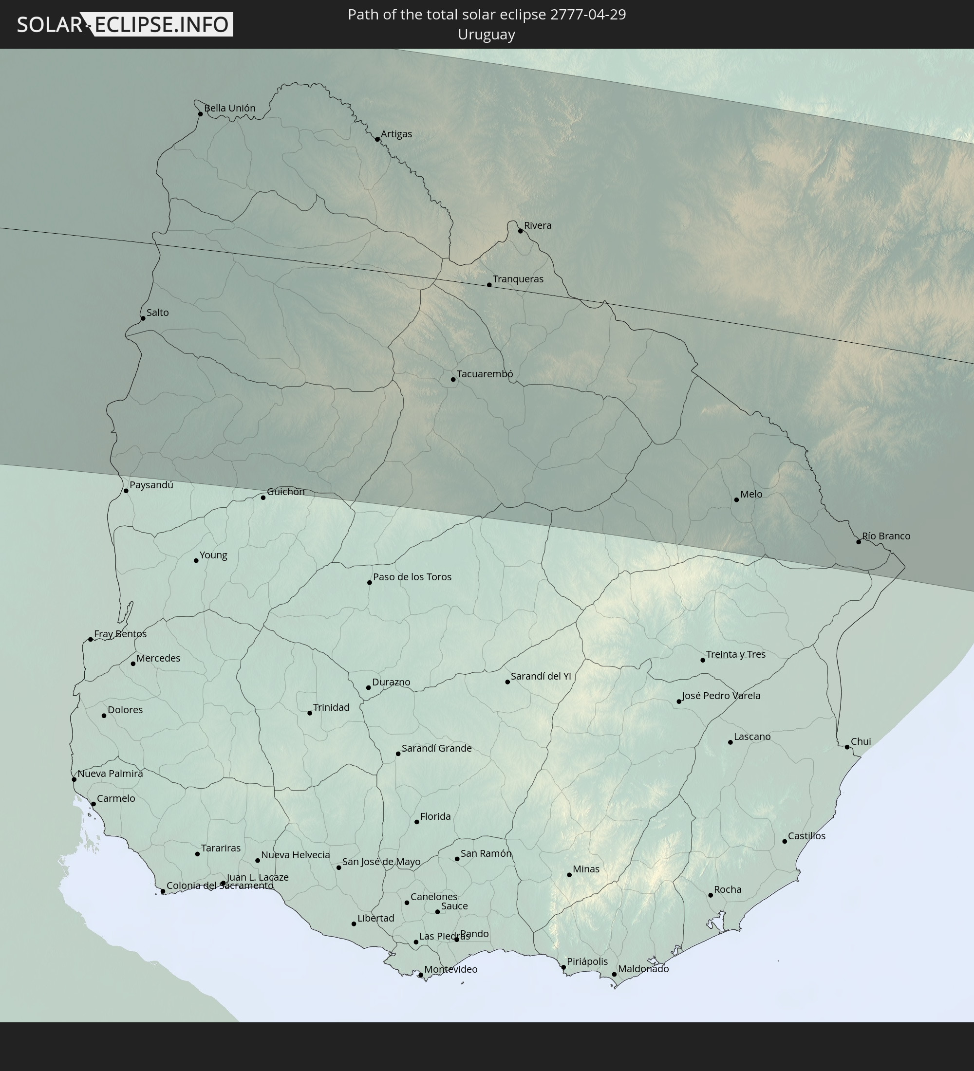 Uruguay
In den folgenden Ländern ist die Sonnenfinsternis partiell zu sehen


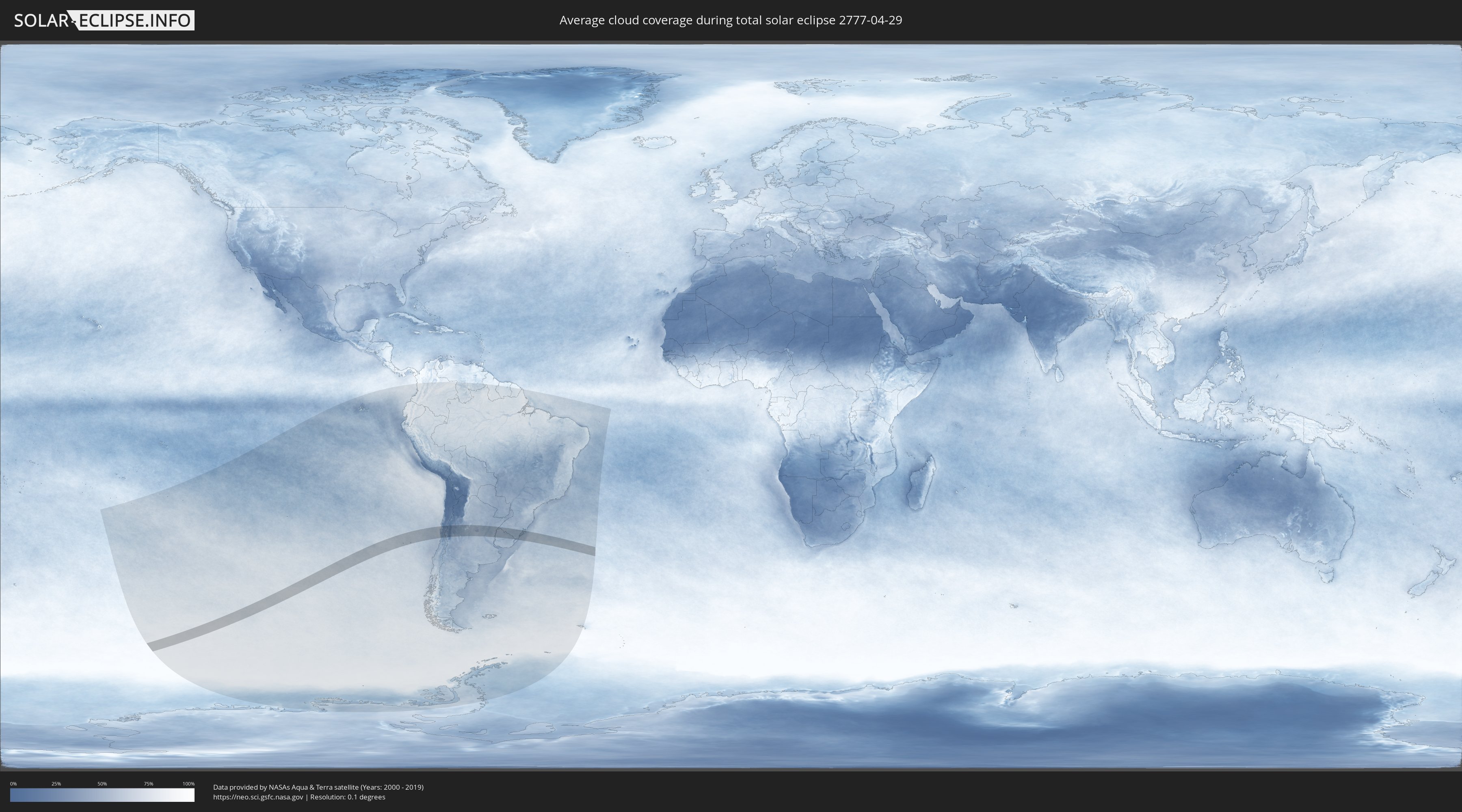
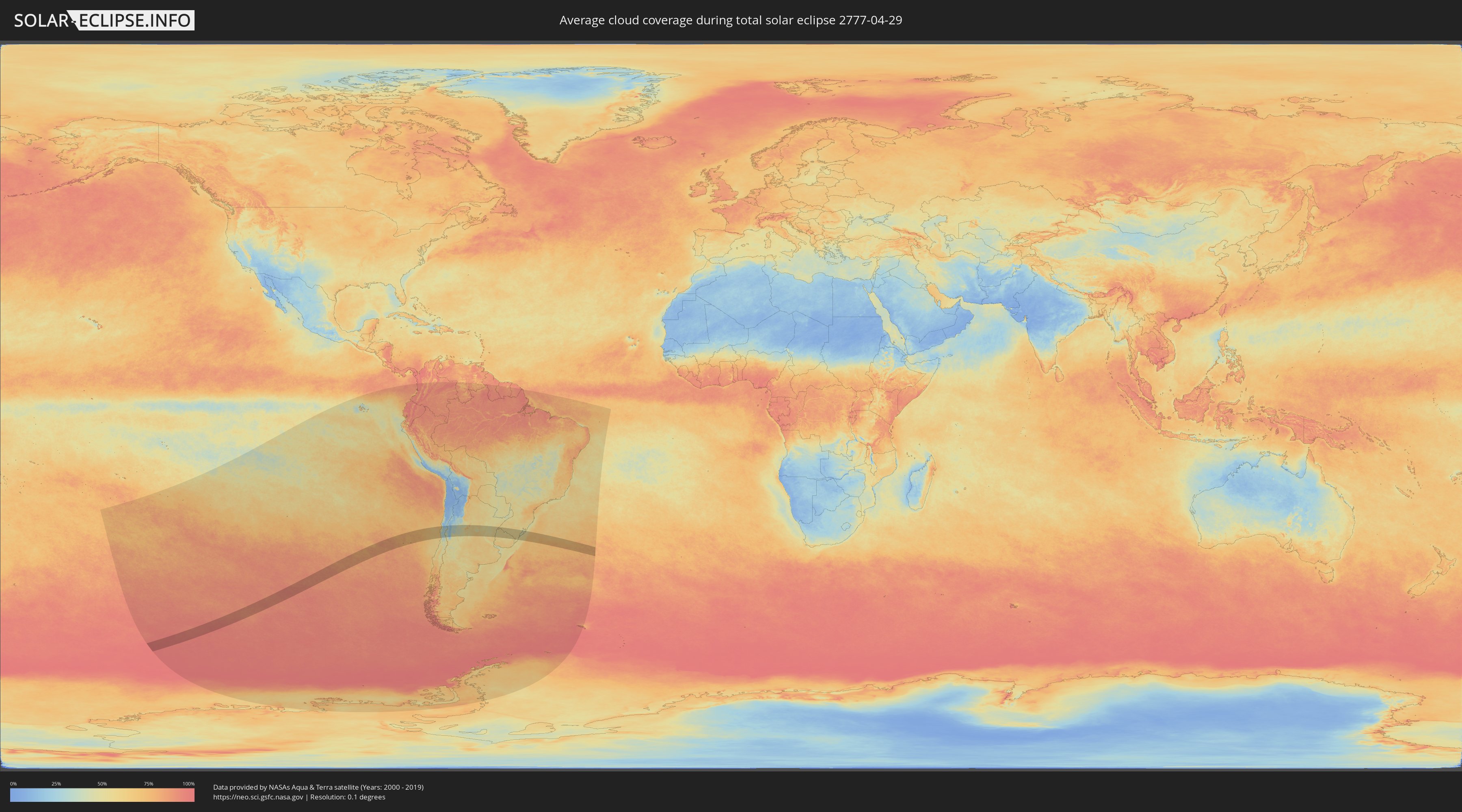
Wie wird das Wetter während der totalen Sonnenfinsternis am 29.04.2777?
Wo ist der beste Ort, um die totale Sonnenfinsternis vom 29.04.2777 zu beobachten?
Die folgenden Karten zeigen die durchschnittliche Bewölkung für den Tag, an dem die totale Sonnenfinsternis
stattfindet. Mit Hilfe der Karten lässt sich der Ort entlang des Finsternispfades eingrenzen,
der die besten Aussichen auf einen klaren wolkenfreien Himmel bietet.
Trotzdem muss man immer lokale Gegenenheiten beachten und sollte sich genau über das Wetter an seinem
gewählten Beobachtungsort informieren.
Die Daten stammen von den beiden NASA-Satelliten
AQUA und TERRA
und wurden über einen Zeitraum von 19 Jahren (2000 - 2019) gemittelt.
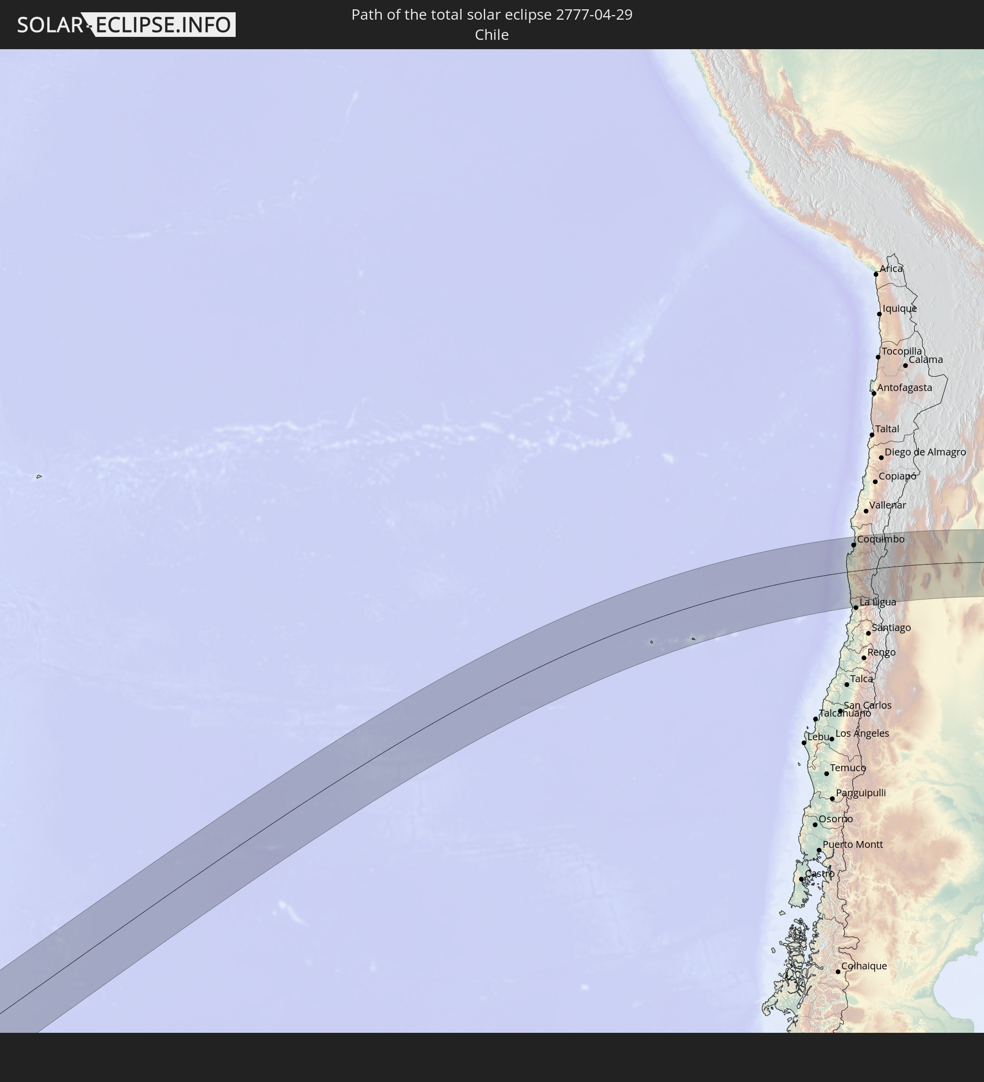
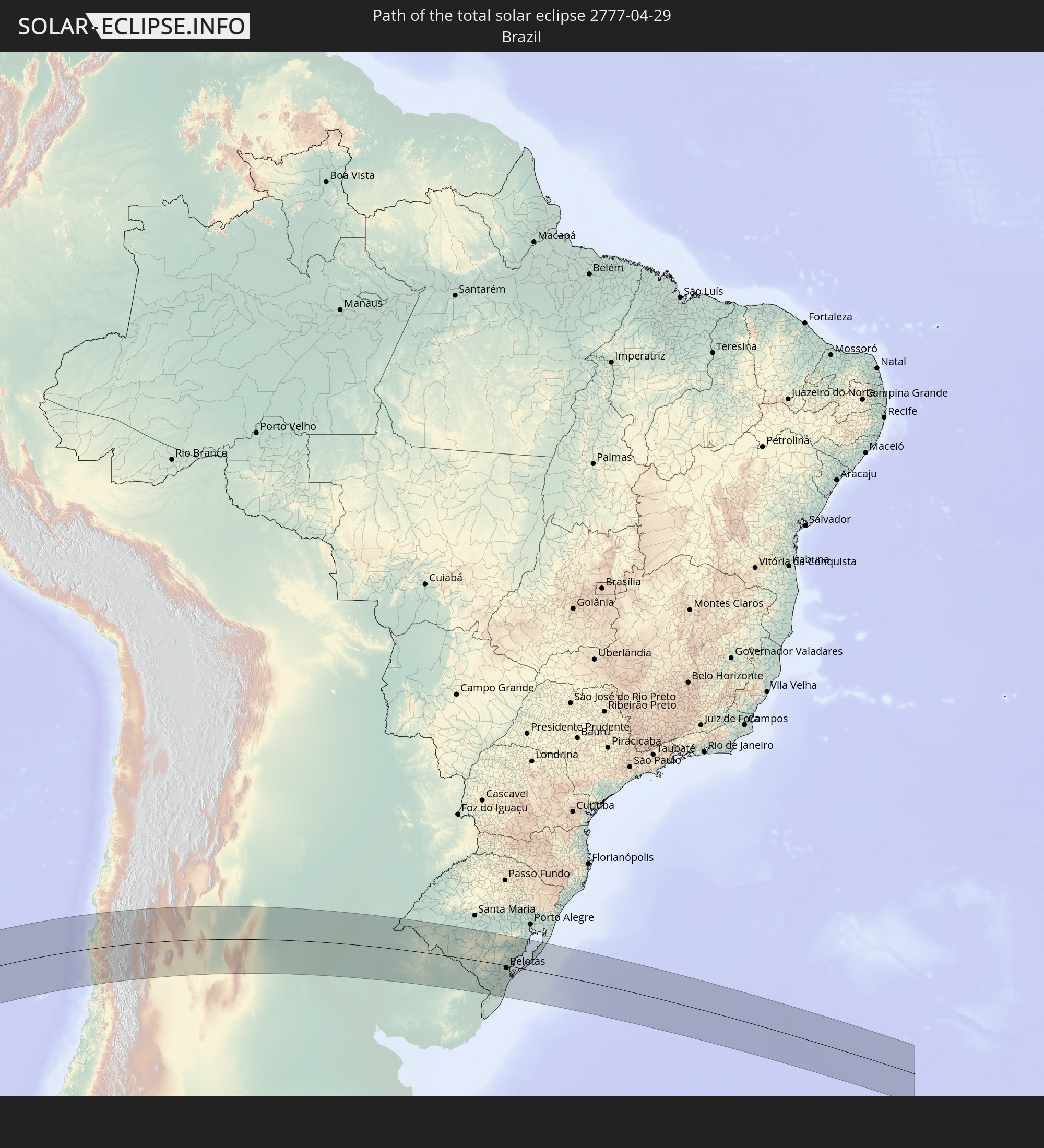
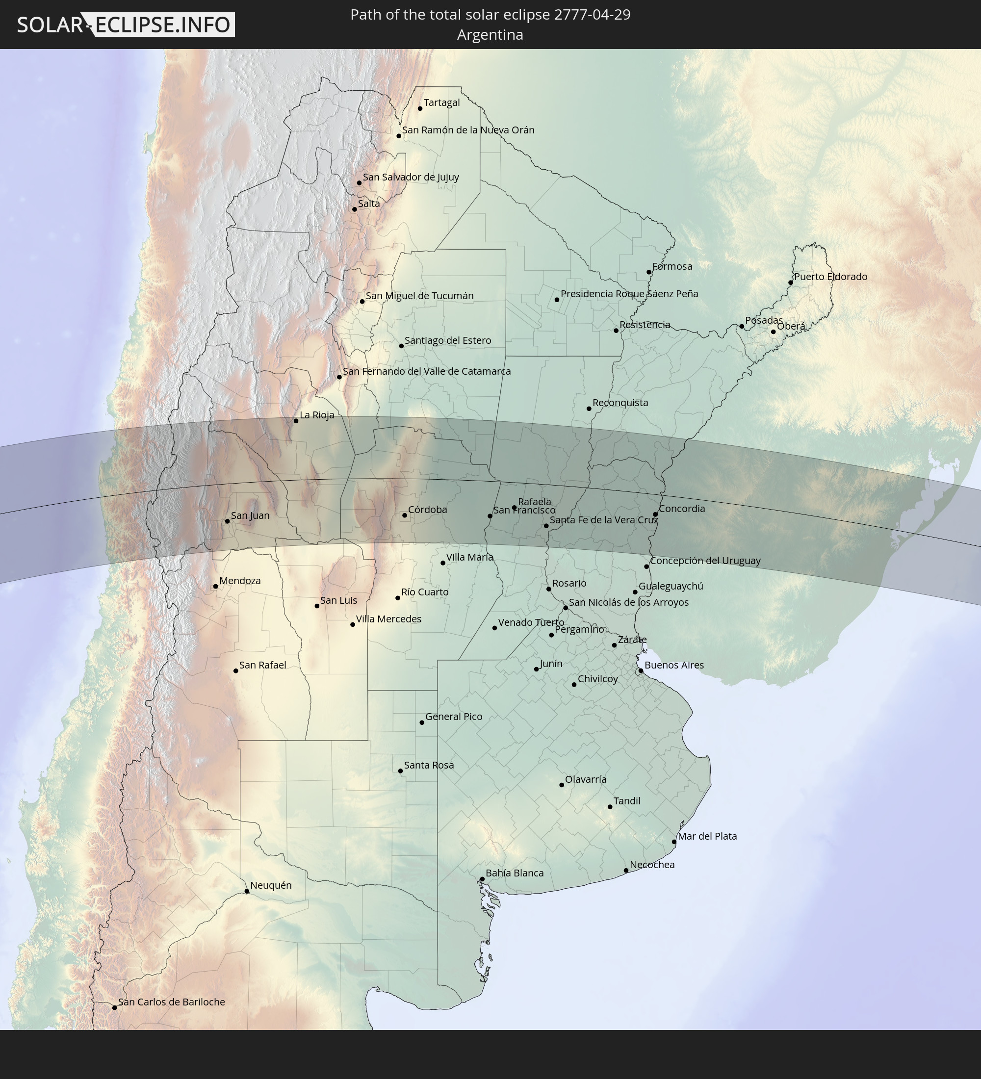
Detaillierte Länderkarten
 Chile
Chile
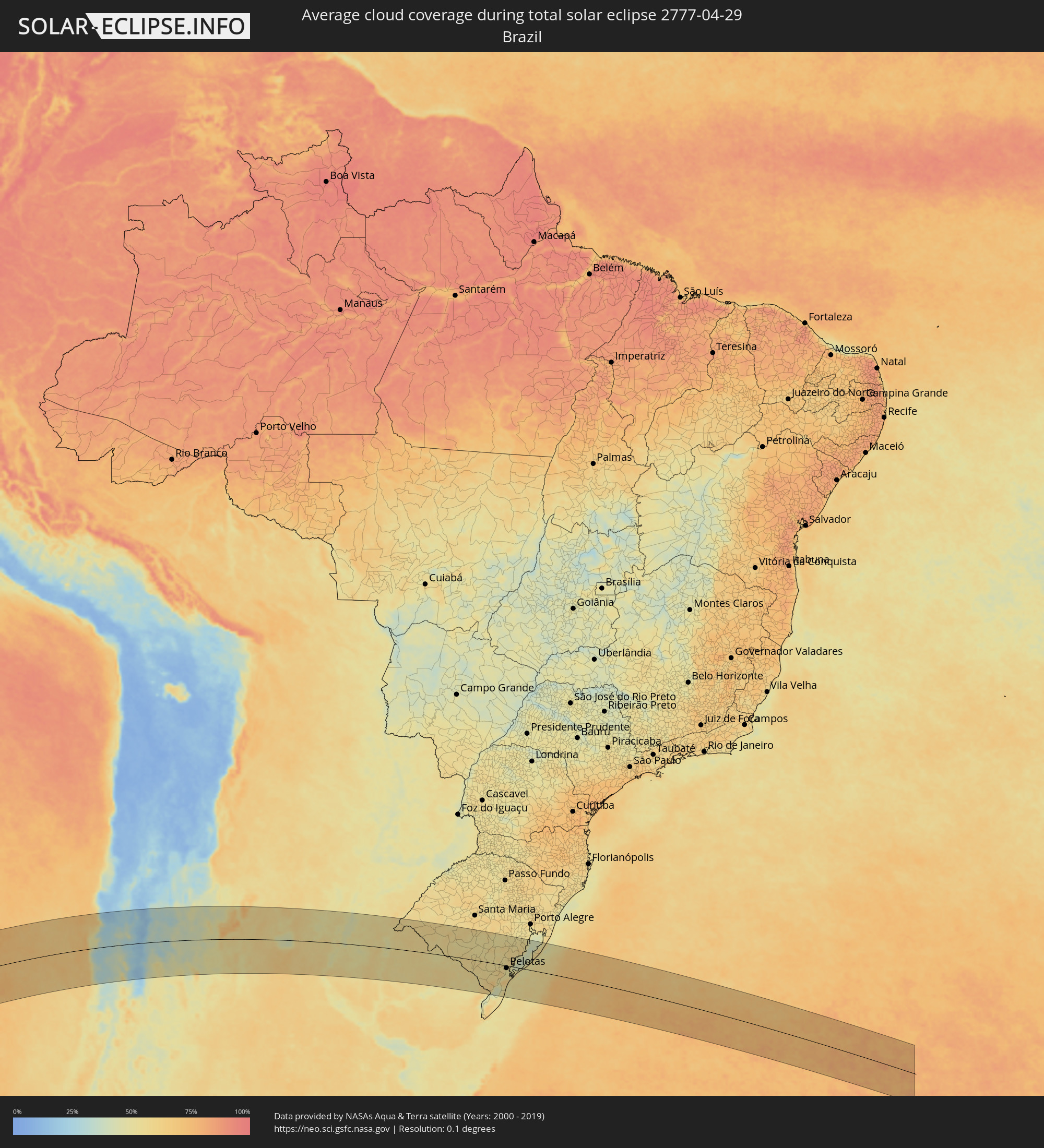 Brasilien
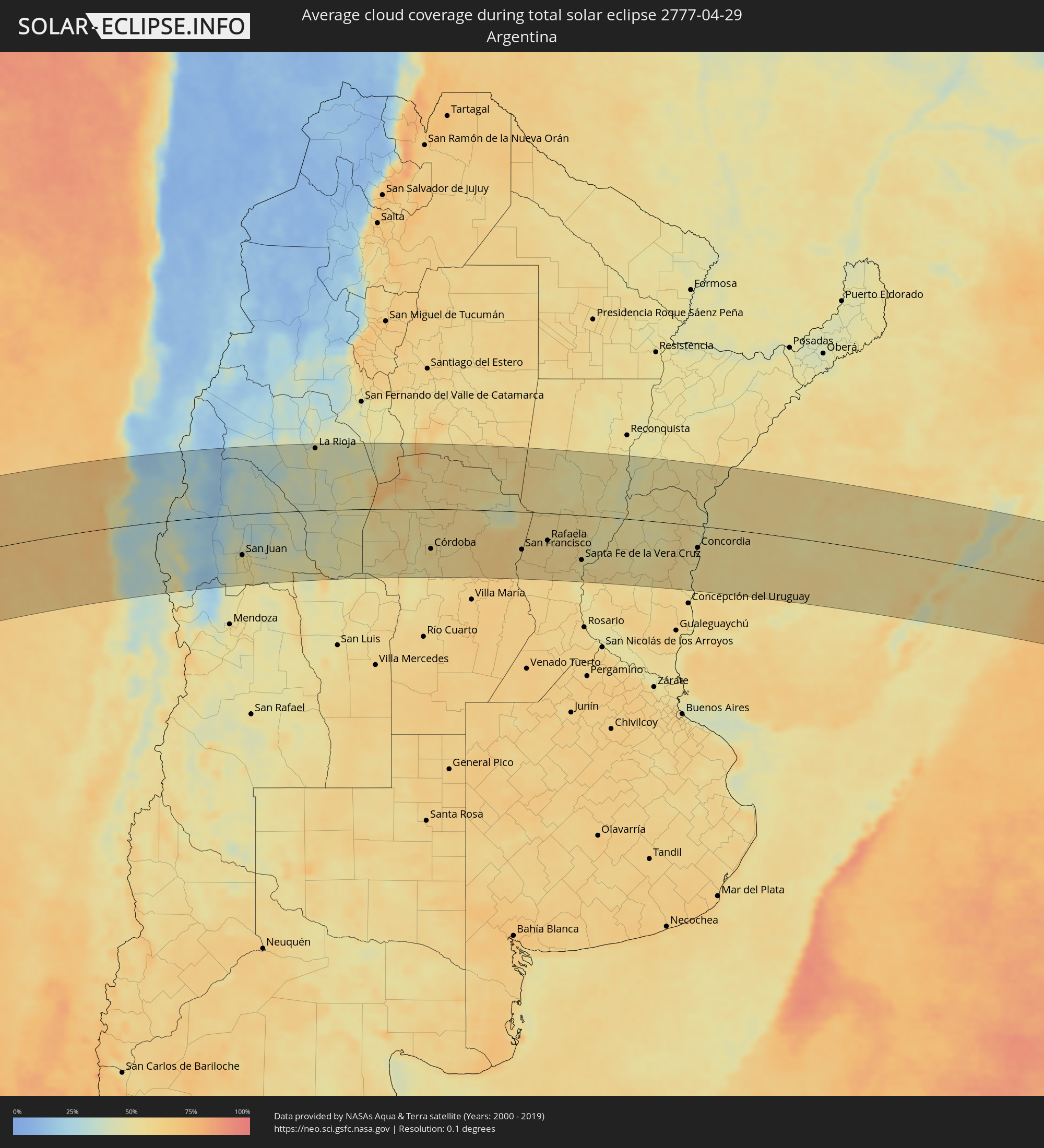 Argentinien
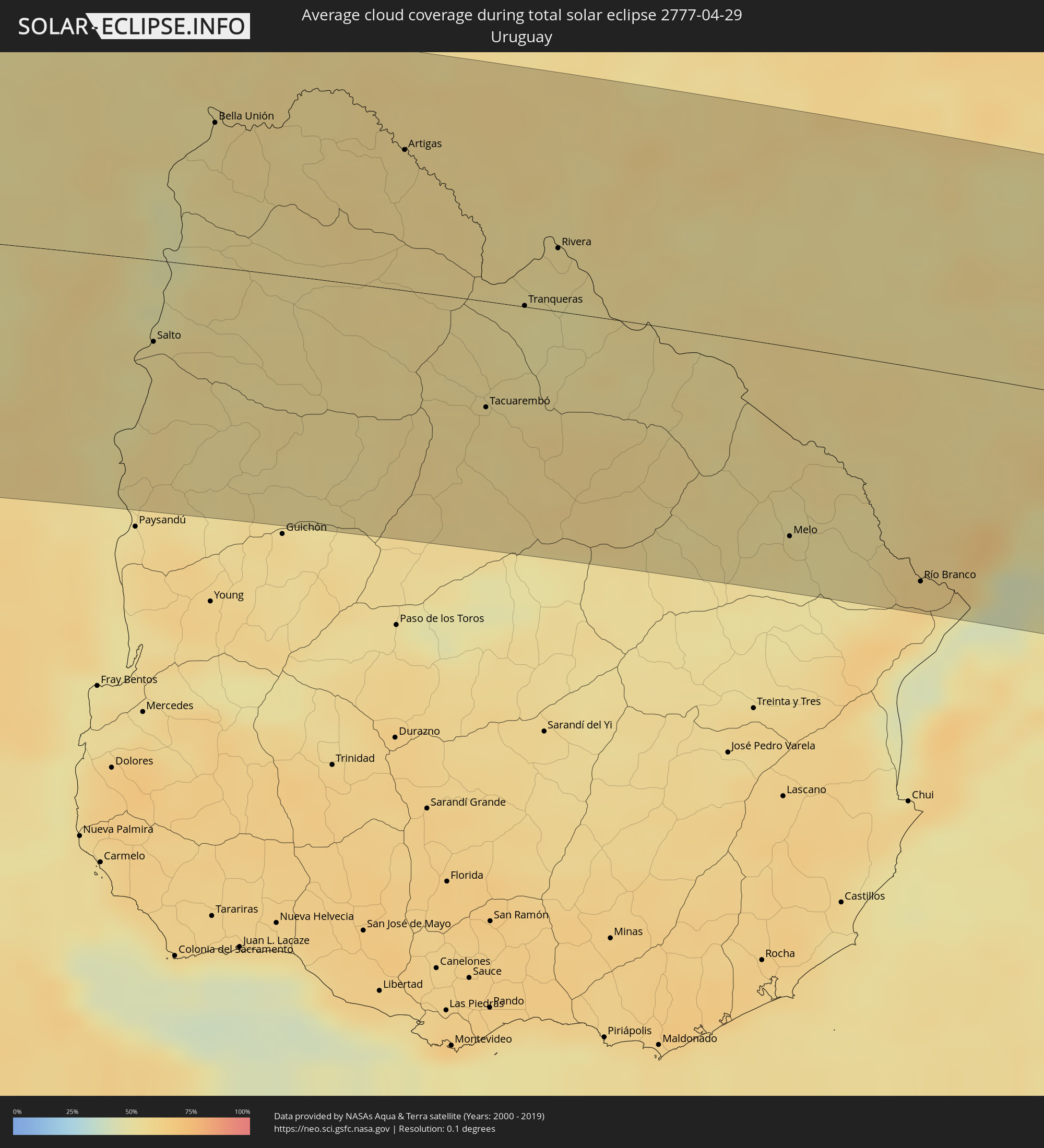 Uruguay
Orte im Finsternispfad
Die nachfolgene Tabelle zeigt Städte und Orte mit mehr als 5.000 Einwohnern, die sich im Finsternispfad befinden. Städte mit mehr als 100.000 Einwohnern sind dick gekennzeichnet. Mit einem Klick auf den Ort öffnet sich eine Detailkarte die die Lage des jeweiligen Ortes zusammen mit dem Verlauf der zentralen Finsternis präsentiert.
| Ort | Typ | Dauer der Verfinsterung | Ortszeit bei maximaler Verfinsterung | Entfernung zur Zentrallinie | Ø Bewölkung |
 Coquimbo, Coquimbo
|
total | - | 15:53:29 UTC-03:00 | 113 km | 59% |
|
La Serena, Coquimbo
|
total | - | 15:53:43 UTC-03:00 | 117 km | 61% |
|
Ovalle, Coquimbo
|
total | - | 15:52:59 UTC-03:00 | 40 km | 43% |
|
Illapel, Coquimbo
|
total | - | 15:51:48 UTC-03:00 | 75 km | 35% |
|
Salamanca, Coquimbo
|
total | - | 15:52:02 UTC-03:00 | 93 km | 31% |
|
Monte Patria, Coquimbo
|
total | - | 15:53:20 UTC-03:00 | 27 km | 33% |
|
Vicuña, Coquimbo
|
total | - | 15:54:36 UTC-03:00 | 97 km | 26% |
 San José de Jáchal, San Juan Province
|
total | - | 15:58:06 UTC-03:00 | 56 km | 36% |
|
Pocito, San Juan Province
|
total | - | 15:56:38 UTC-03:00 | 105 km | 49% |
|
San Juan, San Juan Province
|
total | - | 15:56:54 UTC-03:00 | 89 km | 55% |
|
Caucete, San Juan Province
|
total | - | 15:57:13 UTC-03:00 | 104 km | 51% |
|
La Rioja, La Rioja Province
|
total | - | 16:02:33 UTC-03:00 | 138 km | 47% |
|
Chamical, La Rioja Province
|
total | - | 16:02:20 UTC-03:00 | 31 km | 48% |
|
Villa Dolores, Cordoba Province
|
total | - | 16:02:17 UTC-03:00 | 147 km | 57% |
|
Cruz del Eje, Cordoba Province
|
total | - | 16:04:28 UTC-03:00 | 11 km | 54% |
|
Villa Carlos Paz, Cordoba Province
|
total | - | 16:04:05 UTC-03:00 | 89 km | 50% |
|
La Falda, Cordoba Province
|
total | - | 16:04:32 UTC-03:00 | 52 km | 53% |
|
Cosquín, Cordoba Province
|
total | - | 16:04:22 UTC-03:00 | 69 km | 51% |
|
Alta Gracia, Cordoba Province
|
total | - | 16:03:55 UTC-03:00 | 114 km | 52% |
|
Deán Funes, Cordoba Province
|
total | - | 16:05:36 UTC-03:00 | 23 km | 58% |
|
La Calera, Cordoba Province
|
total | - | 16:04:28 UTC-03:00 | 80 km | 56% |
|
Río Ceballos, Cordoba Province
|
total | - | 16:04:43 UTC-03:00 | 60 km | 55% |
|
Unquillo, Cordoba Province
|
total | - | 16:04:38 UTC-03:00 | 67 km | 55% |
|
Córdoba, Cordoba Province
|
total | - | 16:04:38 UTC-03:00 | 88 km | 61% |
|
Jesús María, Cordoba Province
|
total | - | 16:05:19 UTC-03:00 | 39 km | 55% |
|
Río Segundo, Cordoba Province
|
total | - | 16:04:46 UTC-03:00 | 114 km | 60% |
|
Pilar, Cordoba Province
|
total | - | 16:04:47 UTC-03:00 | 117 km | 60% |
|
Oncativo, Cordoba Province
|
total | - | 16:04:48 UTC-03:00 | 142 km | 58% |
|
Arroyito, Cordoba Province
|
total | - | 16:06:27 UTC-03:00 | 86 km | 63% |
|
Las Varillas, Cordoba Province
|
total | - | 16:06:23 UTC-03:00 | 135 km | 64% |
|
San Francisco, Cordoba Province
|
total | - | 16:07:57 UTC-03:00 | 83 km | 59% |
|
Morteros, Cordoba Province
|
total | - | 16:08:59 UTC-03:00 | 3 km | 58% |
|
Ceres, Santa Fe Province
|
total | - | 16:10:07 UTC-03:00 | 90 km | 58% |
|
San Jorge, Santa Fe Province
|
total | - | 16:07:41 UTC-03:00 | 134 km | 60% |
|
Sunchales, Santa Fe Province
|
total | - | 16:09:22 UTC-03:00 | 27 km | 56% |
|
Rafaela, Santa Fe Province
|
total | - | 16:09:05 UTC-03:00 | 60 km | 57% |
|
San Cristóbal, Santa Fe Province
|
total | - | 16:10:40 UTC-03:00 | 46 km | 54% |
|
Gálvez, Santa Fe Province
|
total | - | 16:08:29 UTC-03:00 | 145 km | 59% |
|
Esperanza, Santa Fe Province
|
total | - | 16:09:40 UTC-03:00 | 79 km | 60% |
|
Coronda, Santa Fe Province
|
total | - | 16:09:00 UTC-03:00 | 137 km | 50% |
|
Recreo, Santa Fe Province
|
total | - | 16:09:54 UTC-03:00 | 82 km | 55% |
|
Santa Fe de la Vera Cruz, Santa Fe Province
|
total | - | 16:09:46 UTC-03:00 | 98 km | 55% |
|
Laguna Paiva, Santa Fe Province
|
total | - | 16:10:15 UTC-03:00 | 61 km | 55% |
|
San Justo, Santa Fe Province
|
total | - | 16:11:01 UTC-03:00 | 3 km | 57% |
|
Paraná, Entre Ríos Province
|
total | - | 16:09:54 UTC-03:00 | 108 km | 56% |
|
Crespo, Entre Ríos Province
|
total | - | 16:09:50 UTC-03:00 | 139 km | 57% |
|
San Javier, Santa Fe Province
|
total | - | 16:12:15 UTC-03:00 | 25 km | 46% |
|
Santa Elena, Entre Ríos Province
|
total | - | 16:11:59 UTC-03:00 | 15 km | 54% |
|
La Paz, Entre Ríos Province
|
total | - | 16:12:26 UTC-03:00 | 9 km | 49% |
|
Esquina, Corrientes Province
|
total | - | 16:13:32 UTC-03:00 | 91 km | 46% |
|
Villaguay, Entre Ríos Province
|
total | - | 16:11:52 UTC-03:00 | 110 km | 56% |
|
Federal, Entre Ríos Province
|
total | - | 16:13:23 UTC-03:00 | 7 km | 51% |
|
Curuzú Cuatiá, Corrientes Province
|
total | - | 16:15:52 UTC-03:00 | 129 km | 53% |
|
Concordia, Entre Ríos Province
|
total | - | 16:13:52 UTC-03:00 | 48 km | 52% |
|
Chajarí, Entre Ríos Province
|
total | - | 16:14:45 UTC-03:00 | 24 km | 50% |
 Salto, Salto
|
total | - | 16:13:57 UTC-03:00 | 46 km | 52% |
|
Federación, Entre Ríos Province
|
total | - | 16:14:31 UTC-03:00 | 4 km | 49% |
|
Monte Caseros, Corrientes Province
|
total | - | 16:15:50 UTC-03:00 | 82 km | 53% |
|
Bella Unión, Artigas
|
total | - | 16:15:53 UTC-03:00 | 82 km | 53% |
|
Artigas, Artigas
|
total | - | 16:17:10 UTC-03:00 | 80 km | 56% |
 Quaraí, Rio Grande do Sul
|
total | - | 16:17:12 UTC-03:00 | 81 km | 56% |
|
Tacuarembó, Tacuarembó
|
total | - | 16:16:05 UTC-03:00 | 60 km | 57% |
|
Tranqueras, Rivera
|
total | - | 16:17:03 UTC-03:00 | 1 km | 52% |
|
Rivera, Rivera
|
total | - | 16:17:40 UTC-03:00 | 36 km | 53% |
|
Santana do Livramento, Rio Grande do Sul
|
total | - | 16:17:43 UTC-03:00 | 37 km | 55% |
|
Rosário do Sul, Rio Grande do Sul
|
total | - | 16:19:16 UTC-03:00 | 116 km | 60% |
|
Dom Pedrito, Rio Grande do Sul
|
total | - | 16:18:38 UTC-03:00 | 39 km | 53% |
|
São Gabriel, Rio Grande do Sul
|
total | - | 16:19:53 UTC-03:00 | 116 km | 59% |
|
Melo, Cerro Largo
|
total | - | 16:17:25 UTC-03:00 | 106 km | 55% |
|
Bagé, Rio Grande do Sul
|
total | - | 16:18:51 UTC-03:00 | 9 km | 58% |
|
Caçapava do Sul, Rio Grande do Sul
|
total | - | 16:20:37 UTC-03:00 | 109 km | 54% |
|
Herval, Rio Grande do Sul
|
total | - | 16:18:46 UTC-03:00 | 56 km | 57% |
|
Río Branco, Cerro Largo
|
total | - | 16:18:01 UTC-03:00 | 118 km | 63% |
|
Pinheiro Machado, Rio Grande do Sul
|
total | - | 16:19:21 UTC-03:00 | 7 km | 55% |
|
Jaguarão, Rio Grande do Sul
|
total | - | 16:18:04 UTC-03:00 | 115 km | 63% |
|
Arroio Grande, Rio Grande do Sul
|
total | - | 16:18:50 UTC-03:00 | 74 km | 62% |
|
Canguçu, Rio Grande do Sul
|
total | - | 16:20:23 UTC-03:00 | 25 km | 55% |
|
Encruzilhada do Sul, Rio Grande do Sul
|
total | - | 16:21:38 UTC-03:00 | 121 km | 52% |
|
Pelotas, Rio Grande do Sul
|
total | - | 16:20:15 UTC-03:00 | 11 km | 50% |
|
Rio Grande, Rio Grande do Sul
|
total | - | 16:20:10 UTC-03:00 | 35 km | 54% |
|
São Lourenço do Sul, Rio Grande do Sul
|
total | - | 16:21:10 UTC-03:00 | 40 km | 51% |
|
Camaquã, Rio Grande do Sul
|
total | - | 16:22:00 UTC-03:00 | 99 km | 59% |
|
Tapes, Rio Grande do Sul
|
total | - | 16:22:40 UTC-03:00 | 126 km | 50% |