Totale Sonnenfinsternis vom 12.05.2841
| Wochentag: | Sonntag |
| Maximale Dauer der Verfinsterung: | 02m55s |
| Maximale Breite des Finsternispfades: | 105 km |
| Saroszyklus: | 161 |
| Bedeckungsgrad: | 100% |
| Magnitude: | 1.0312 |
| Gamma: | 0.0129 |
Wo kann man die Sonnenfinsternis vom 12.05.2841 sehen?
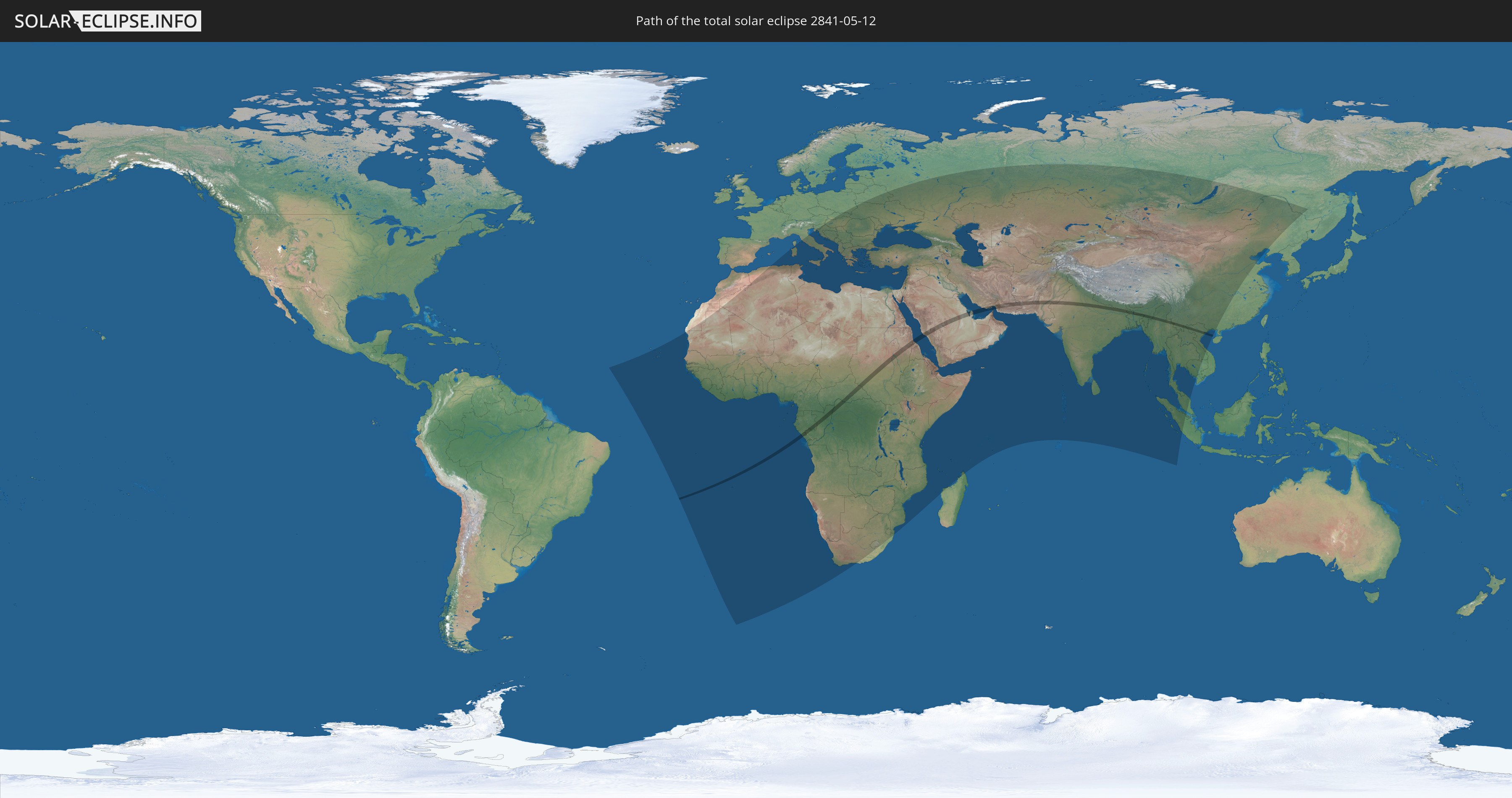
Die Sonnenfinsternis am 12.05.2841 kann man in 118 Ländern als partielle Sonnenfinsternis beobachten.
Der Finsternispfad verläuft durch 20 Länder. Nur in diesen Ländern ist sie als totale Sonnenfinsternis zu sehen.
In den folgenden Ländern ist die Sonnenfinsternis total zu sehen
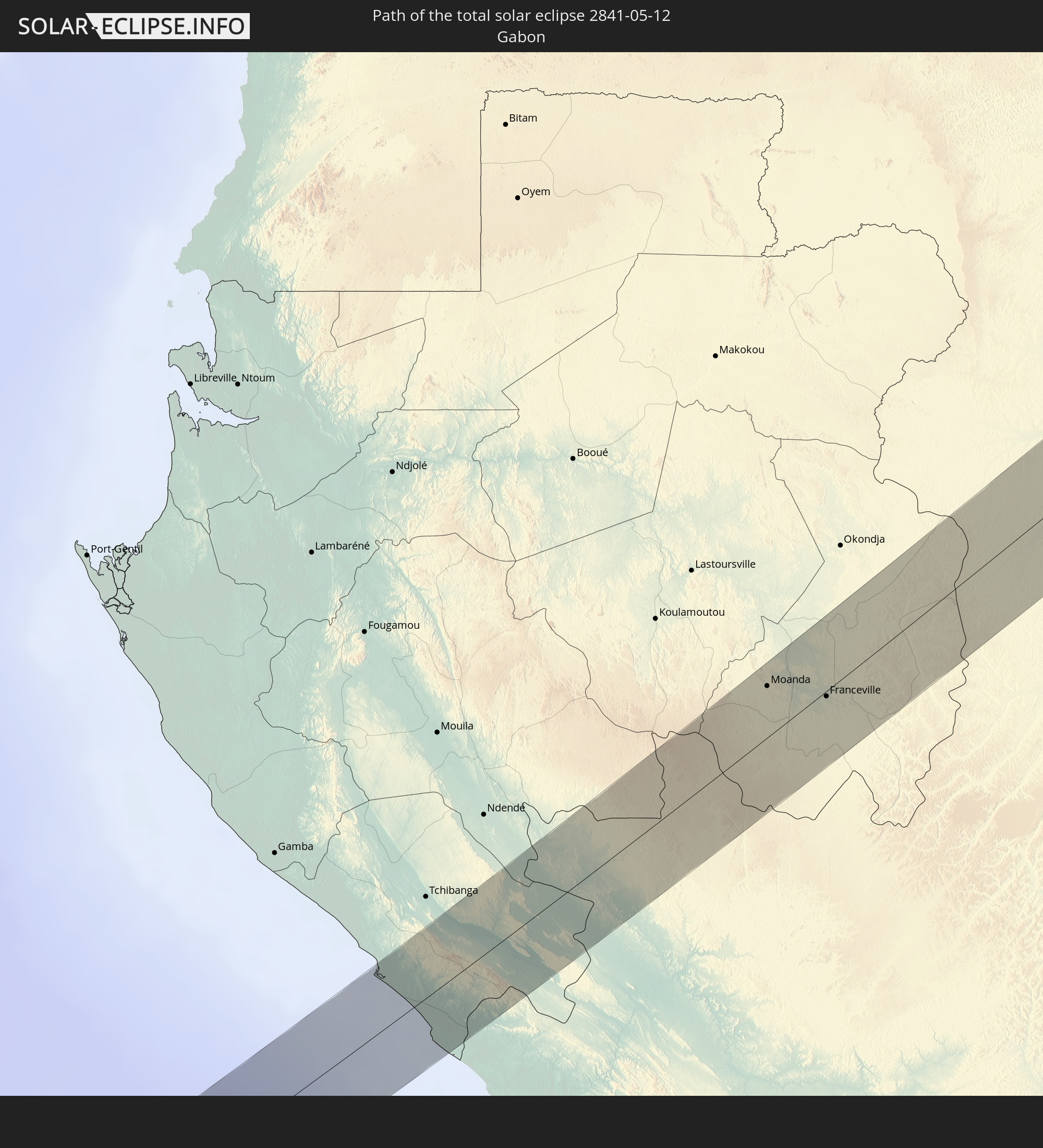 Gabun
Gabun
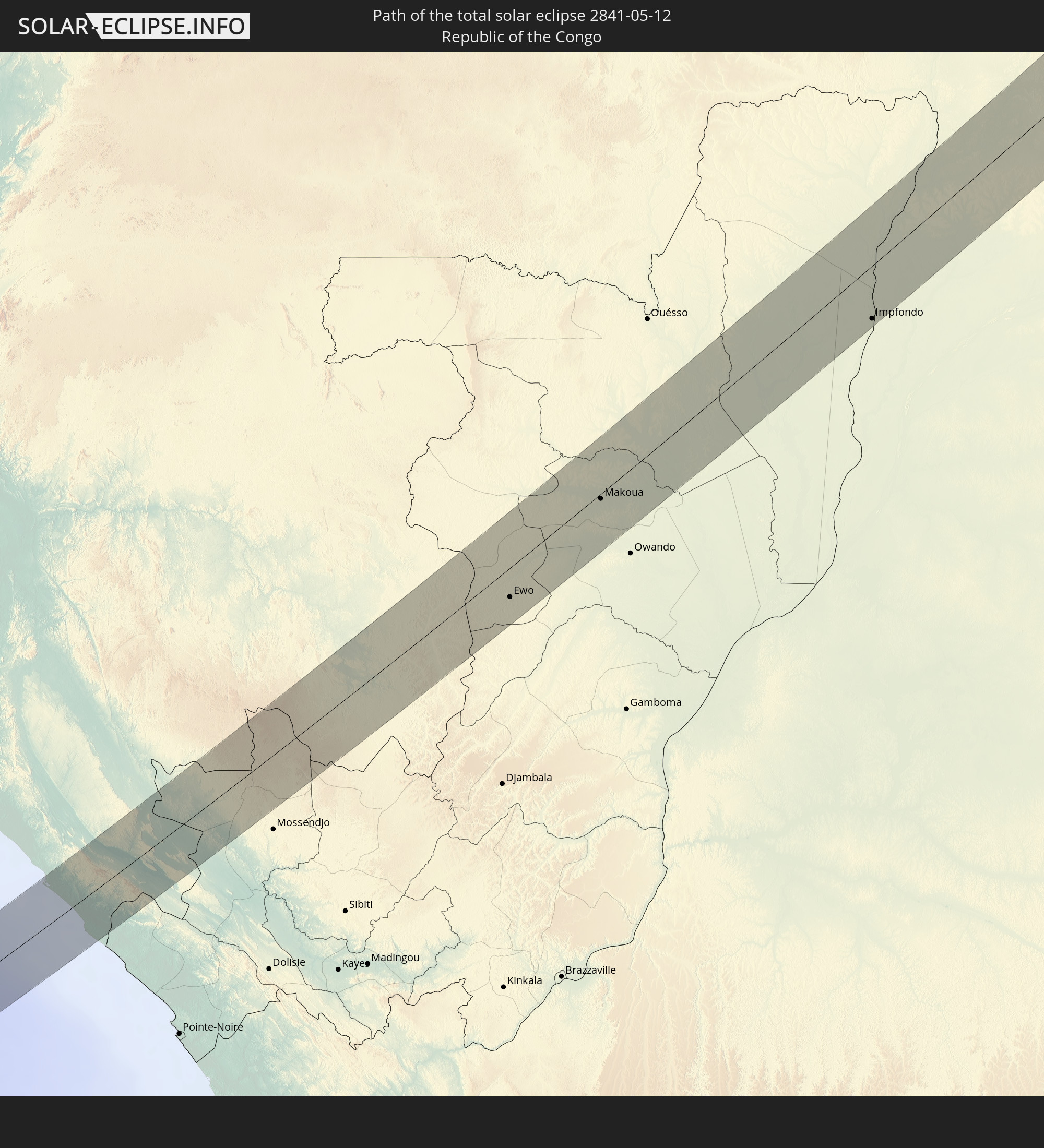 Republik Kongo
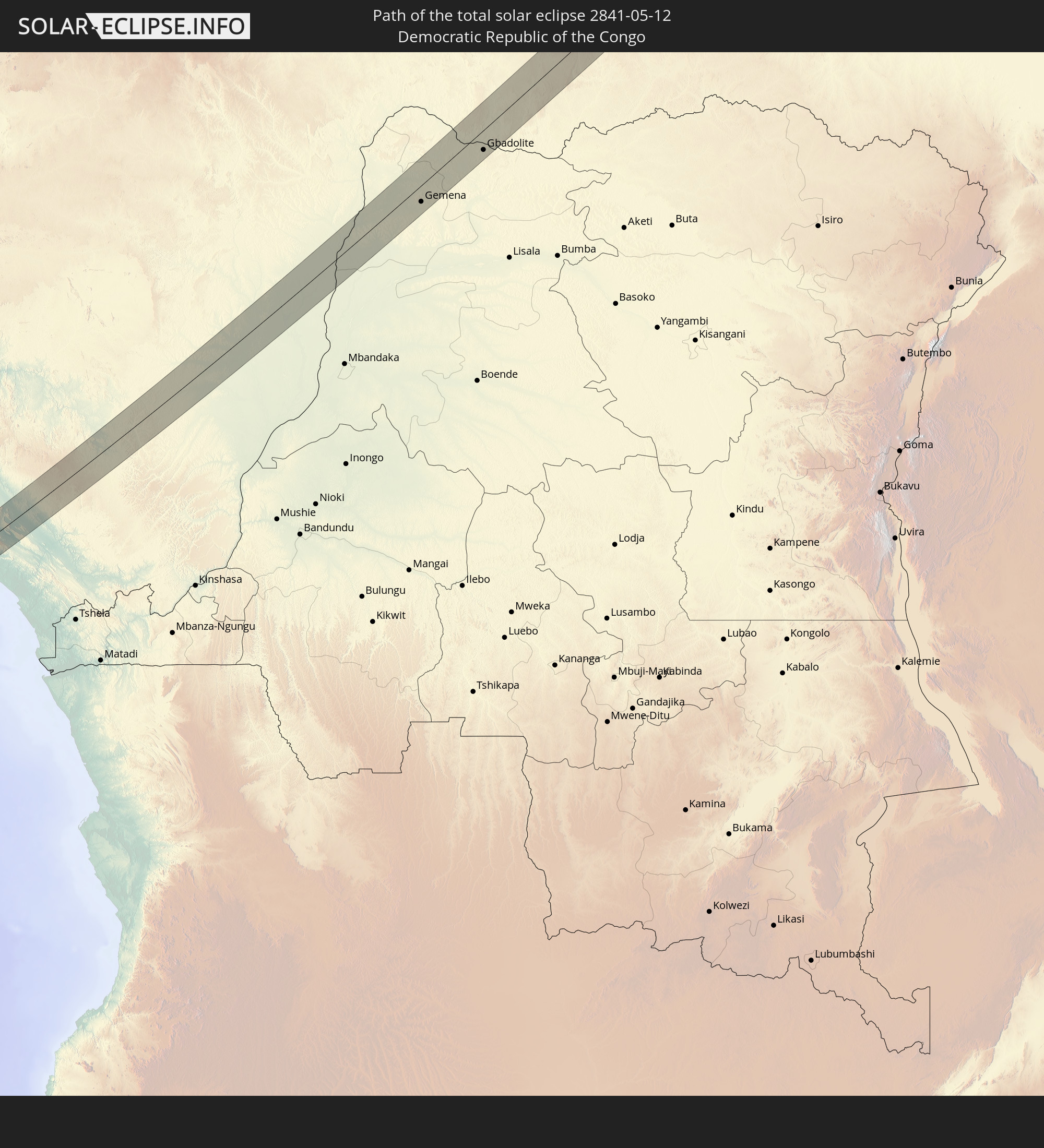 Demokratische Republik Kongo
 Zentralafrikanische Republik
 Sudan
Sudan
 Südsudan
 Saudi-Arabien
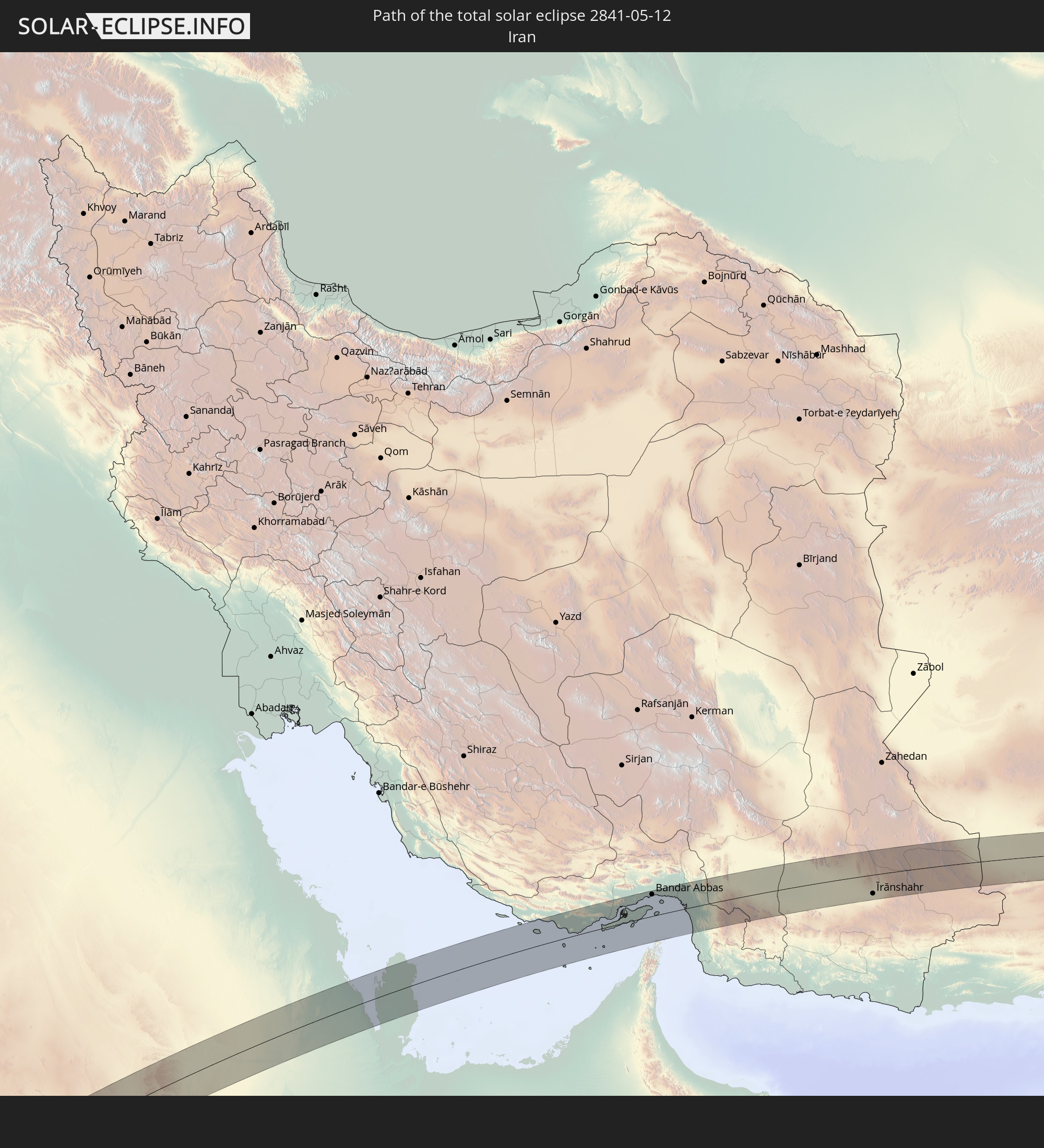 Iran
Iran
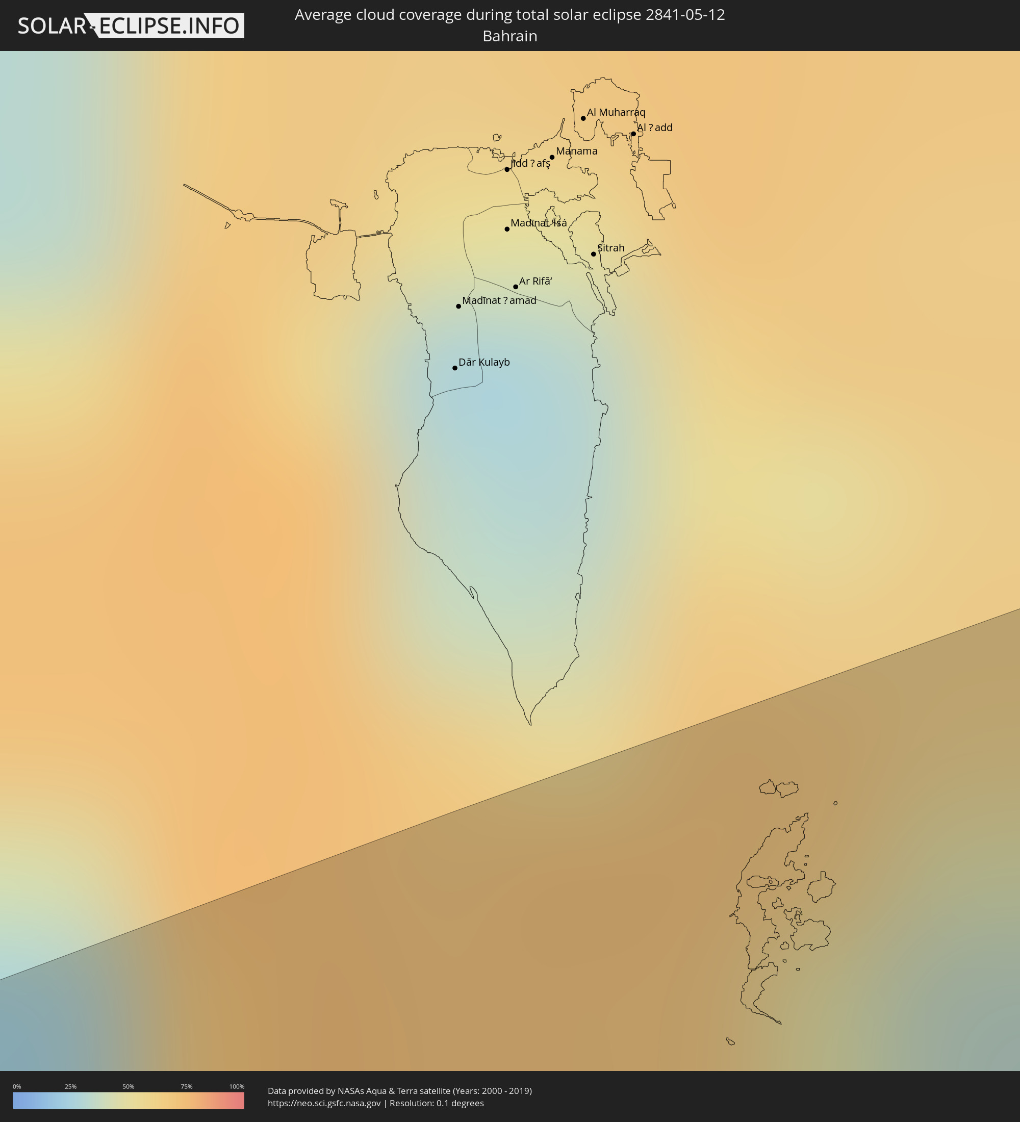
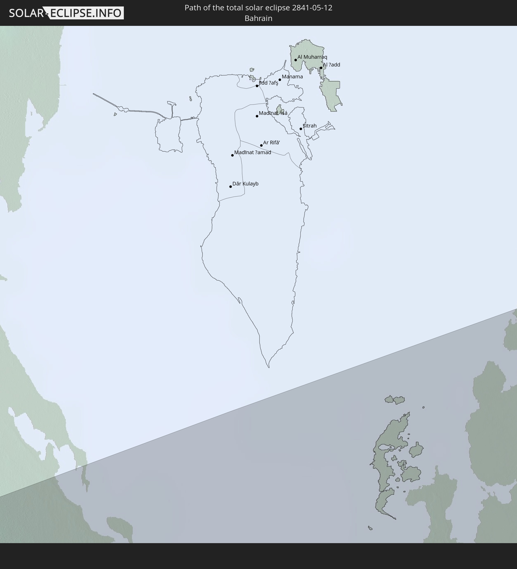 Bahrain
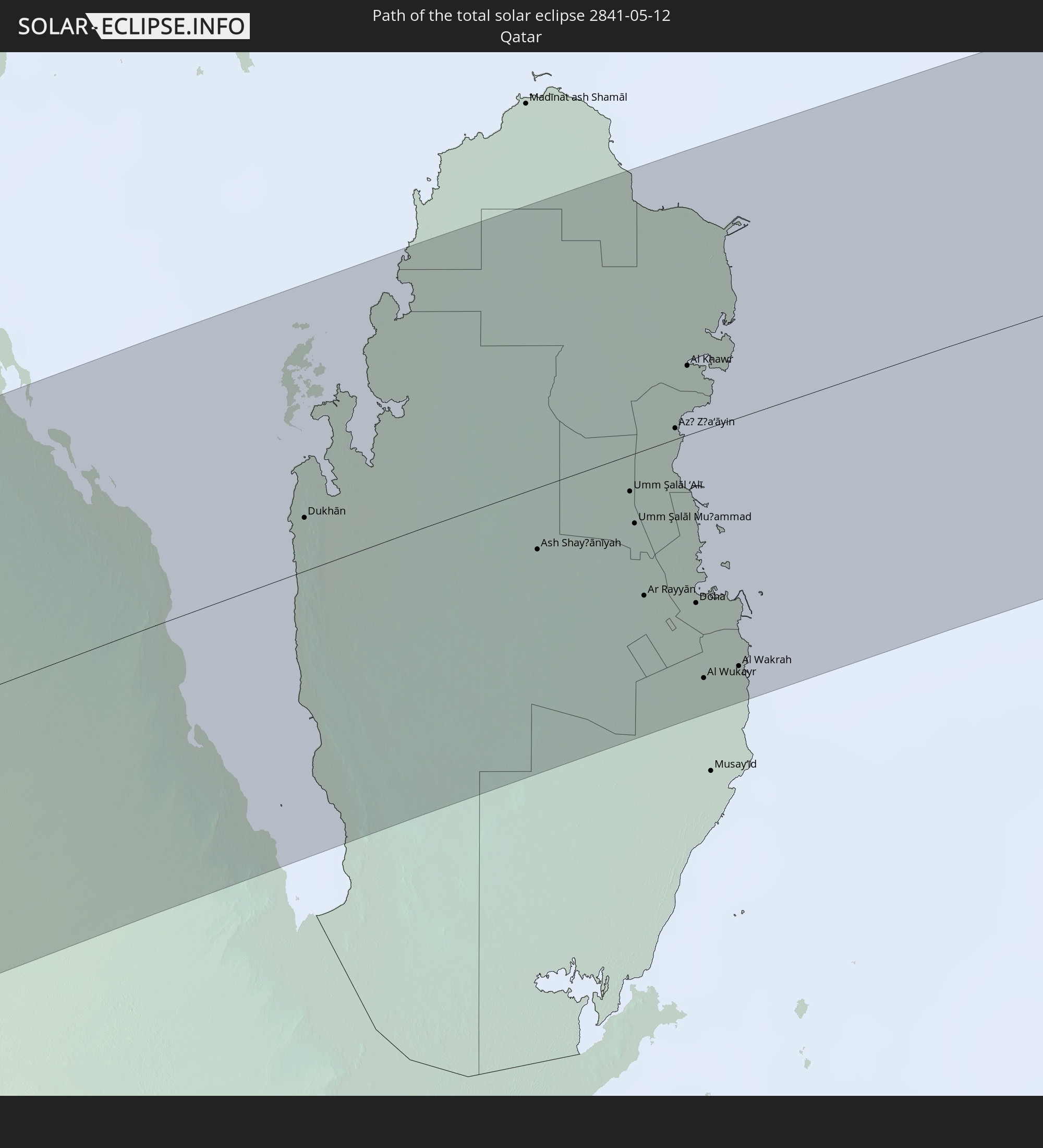 Katar
Katar
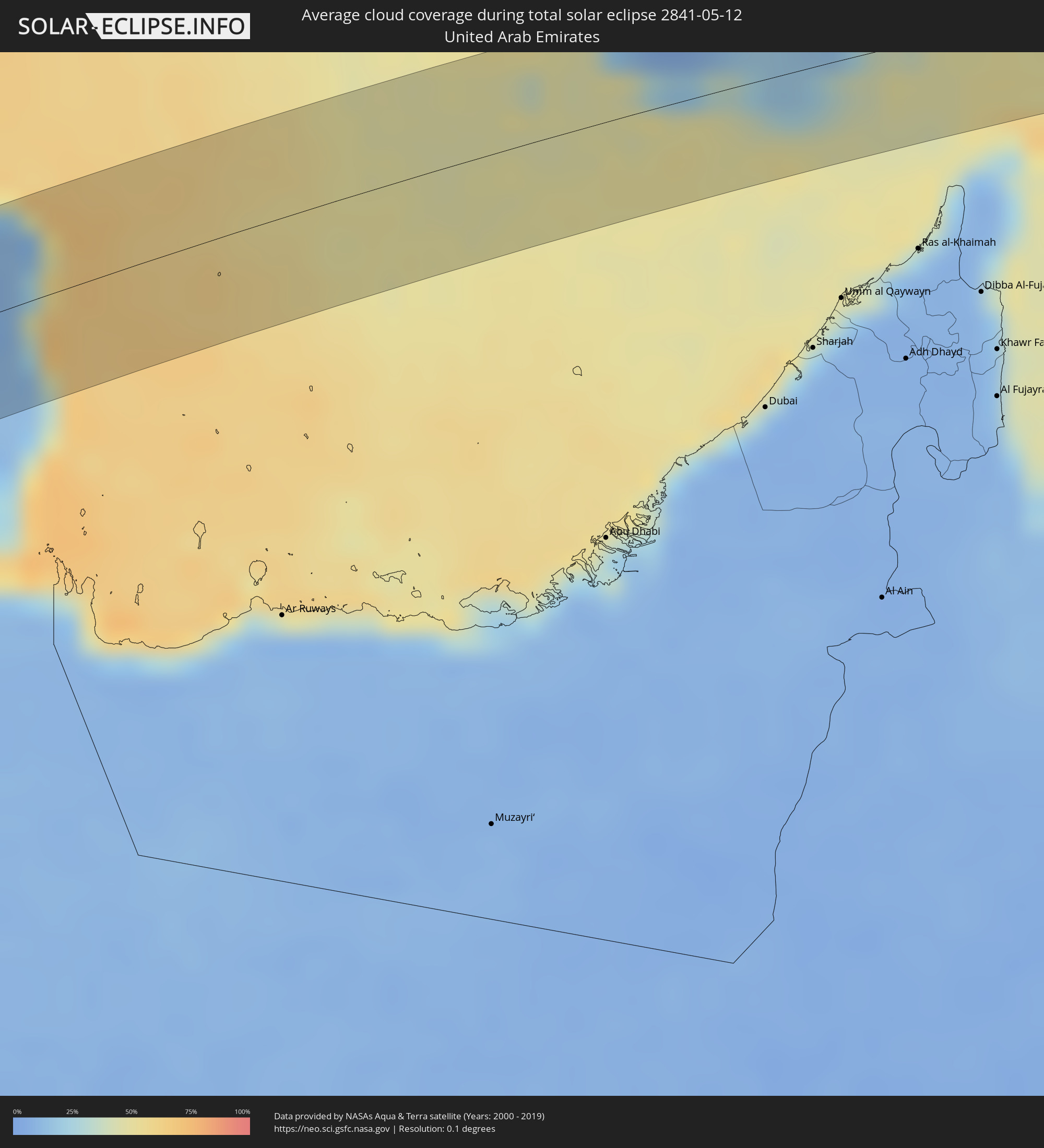
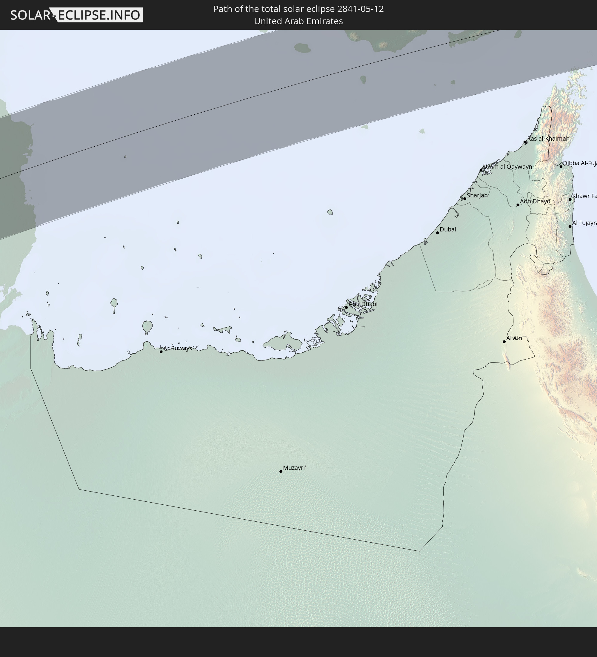 Vereinigte Arabische Emirate
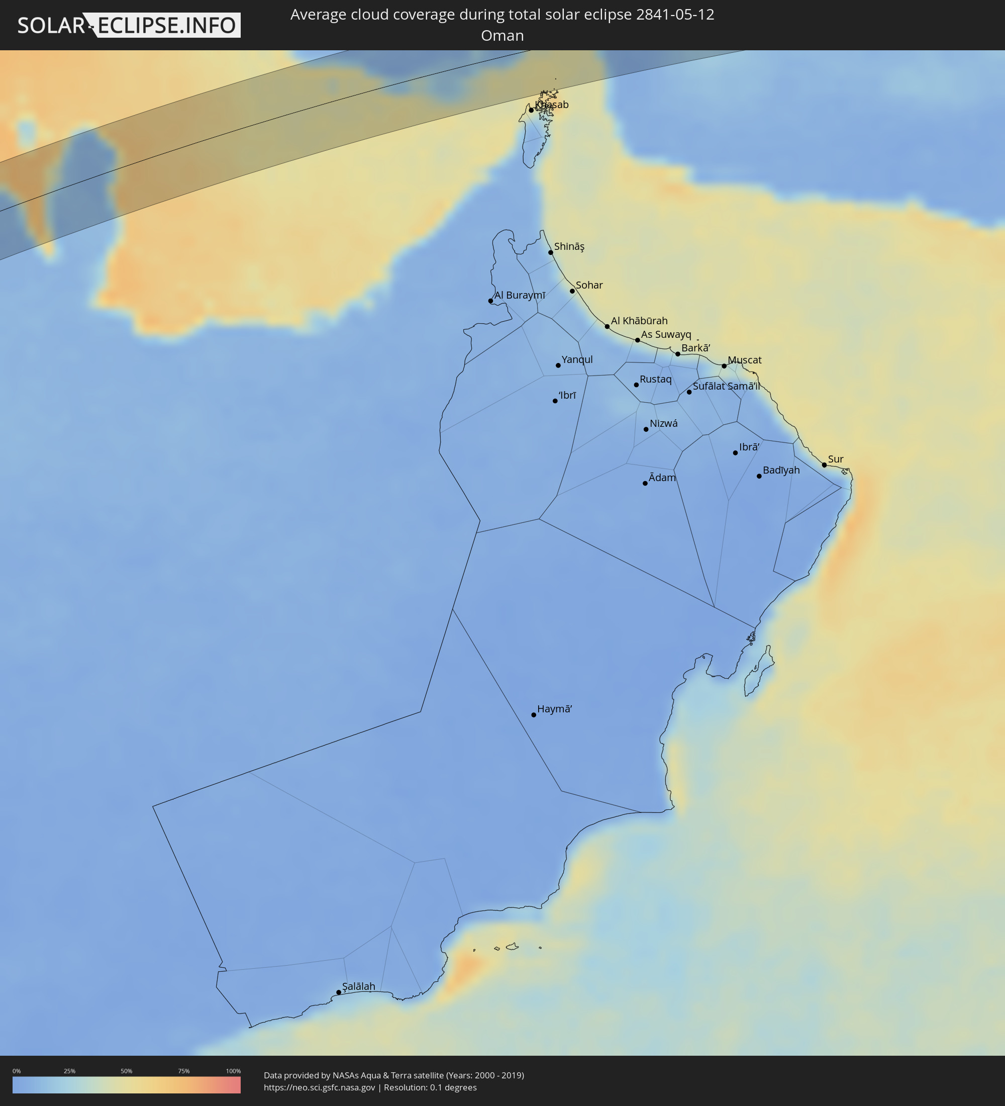
 Oman
Oman
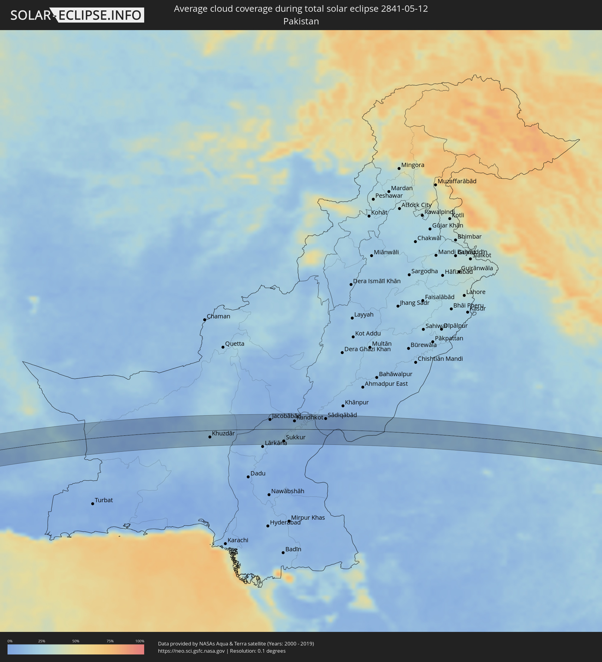
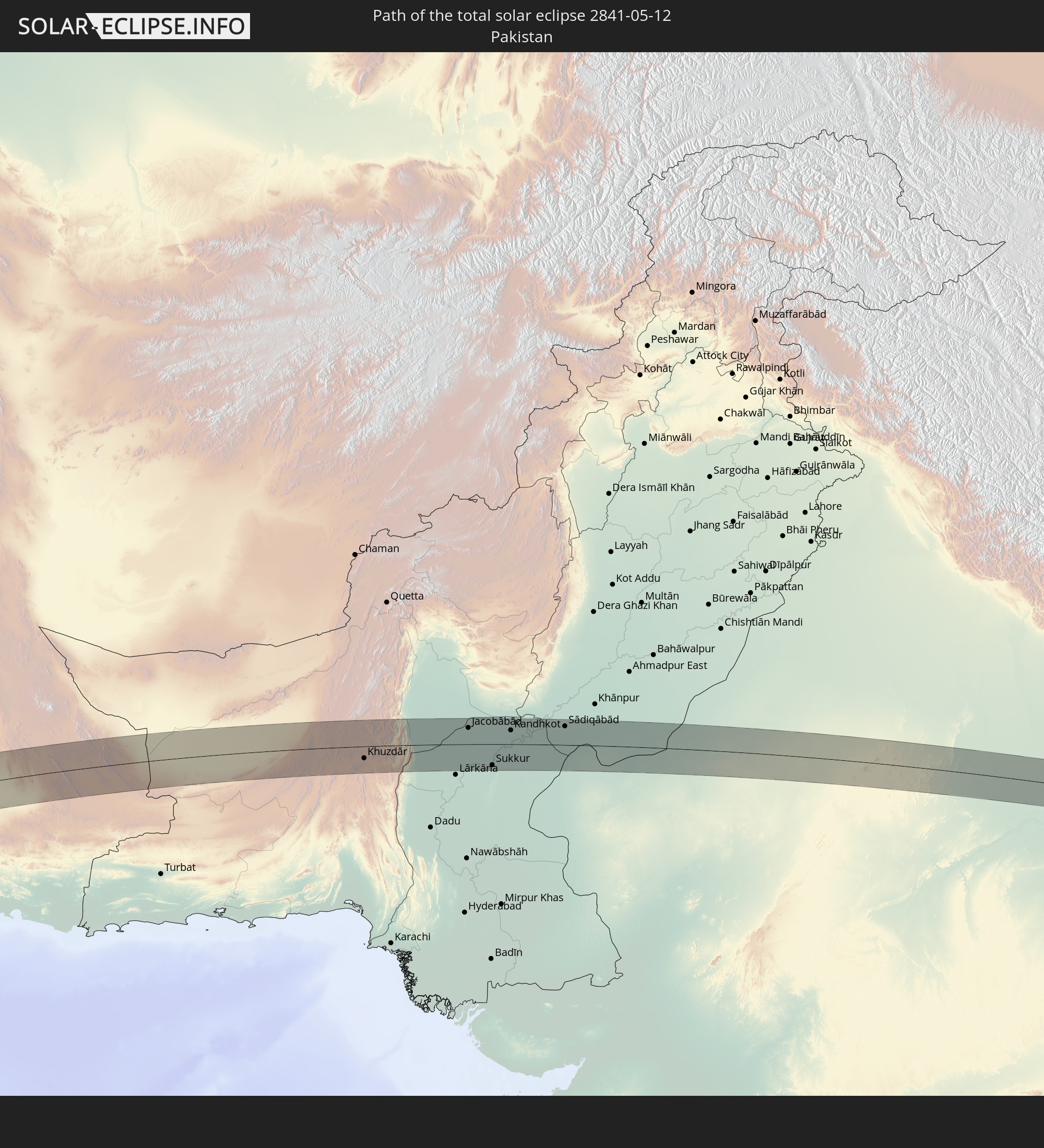 Pakistan
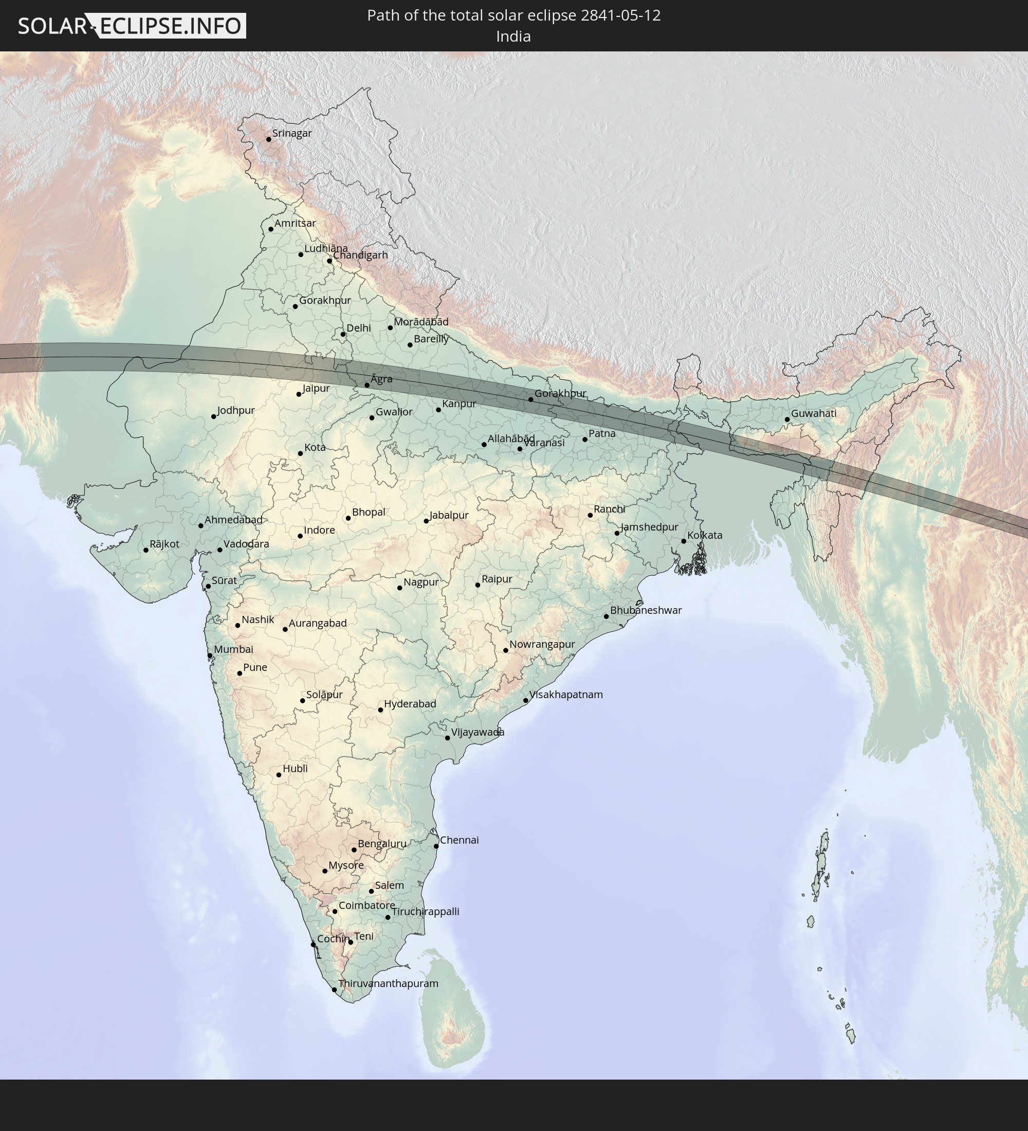 Indien
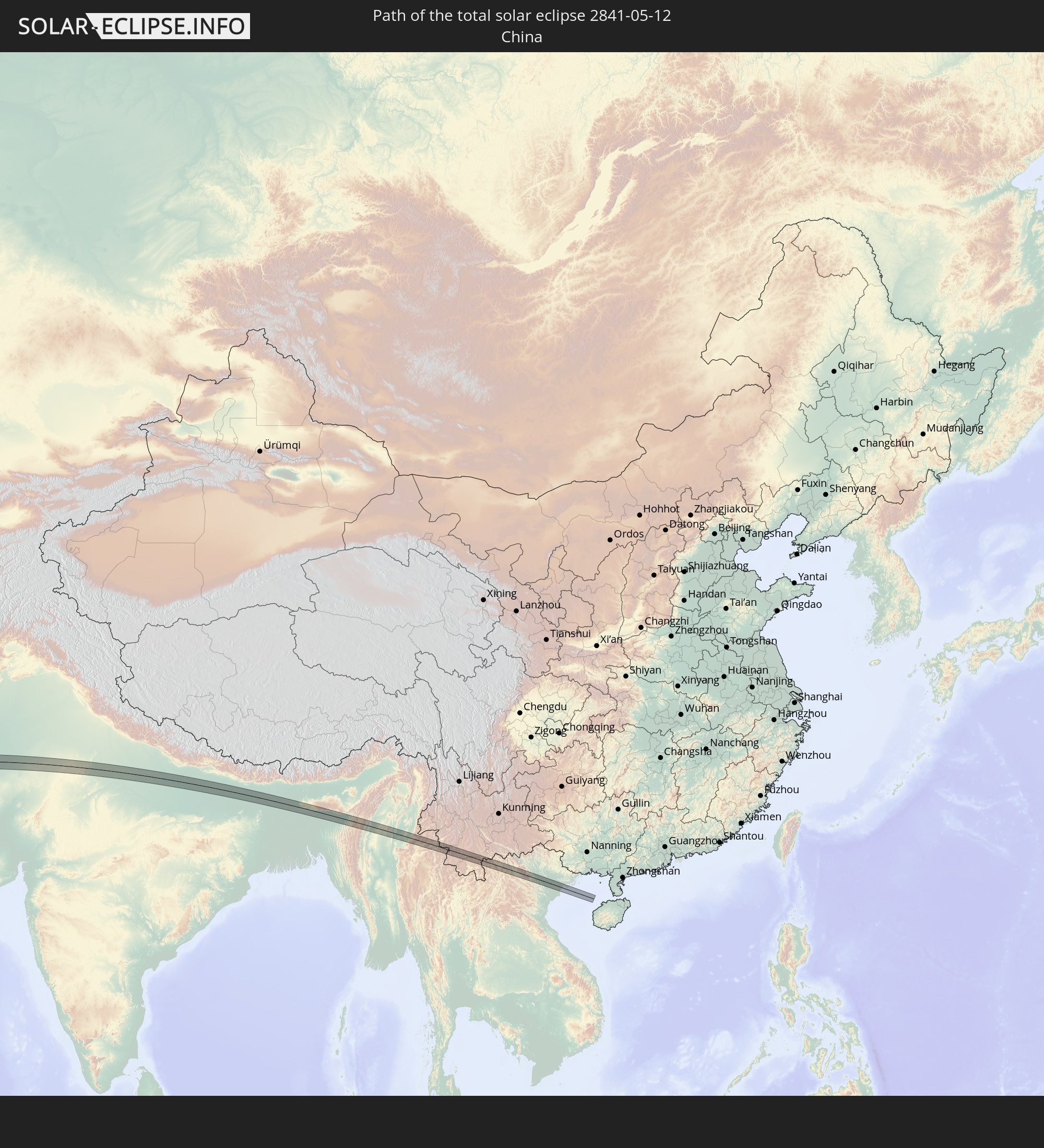 Volksrepublik China
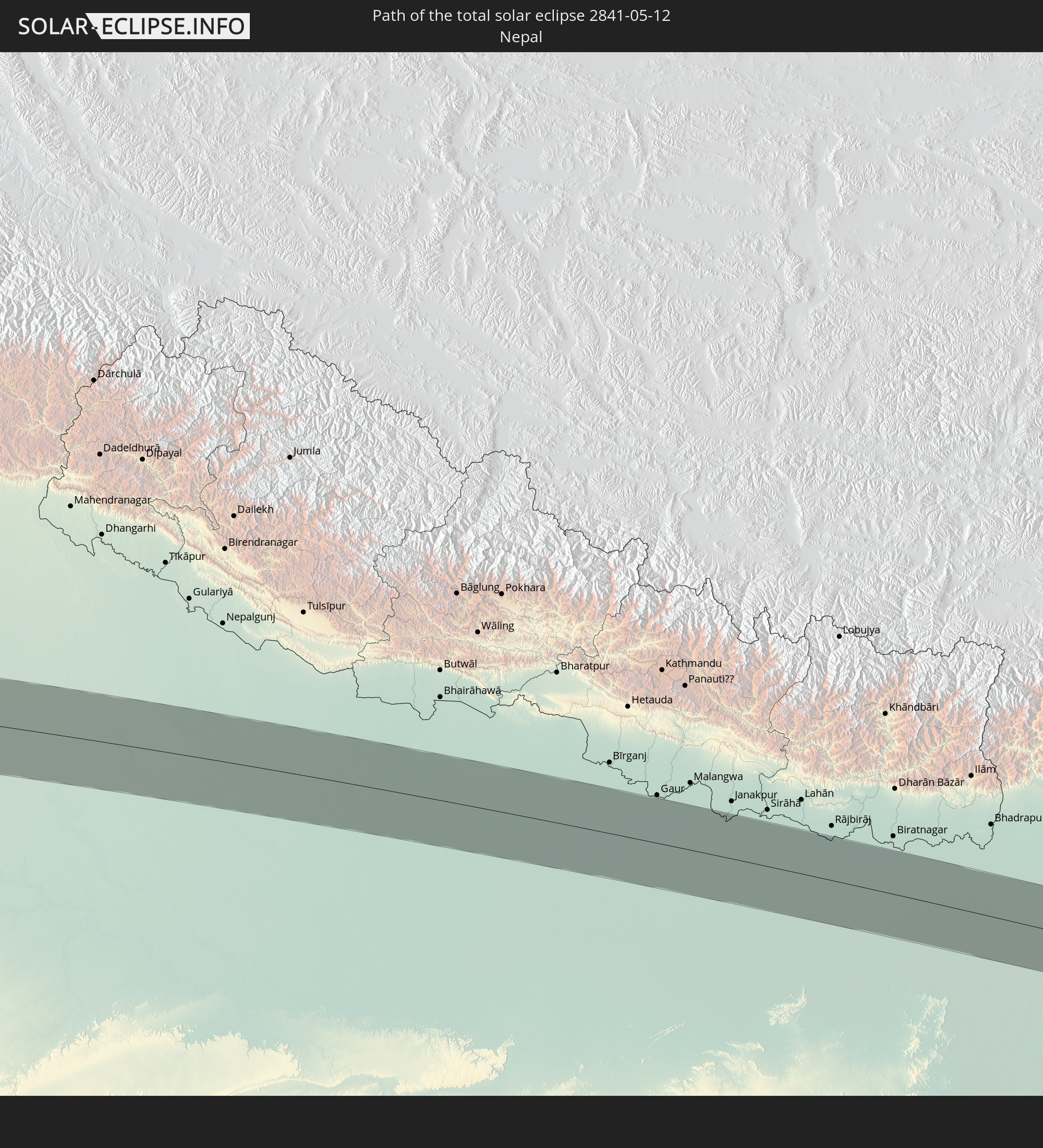 Nepal
Nepal
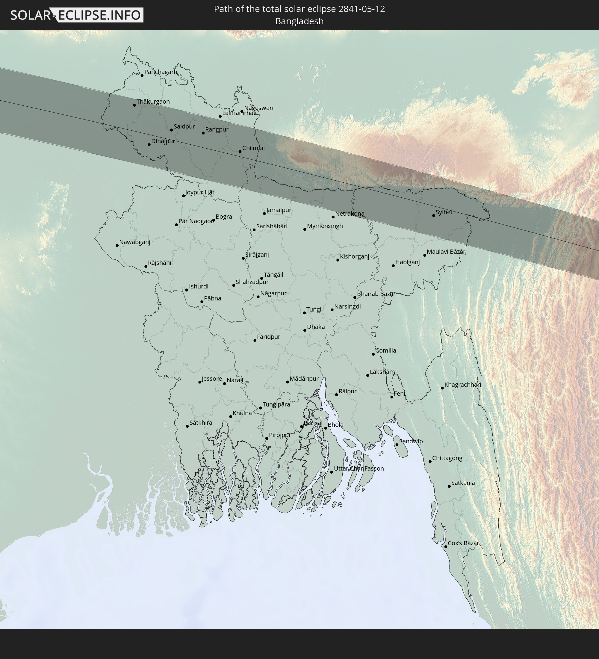 Bangladesch
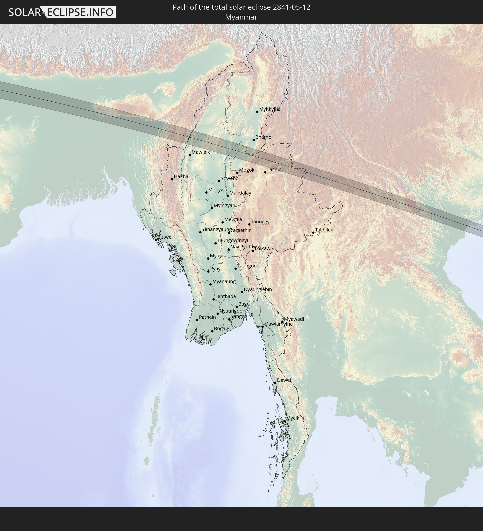 Myanmar
 Laos
Laos
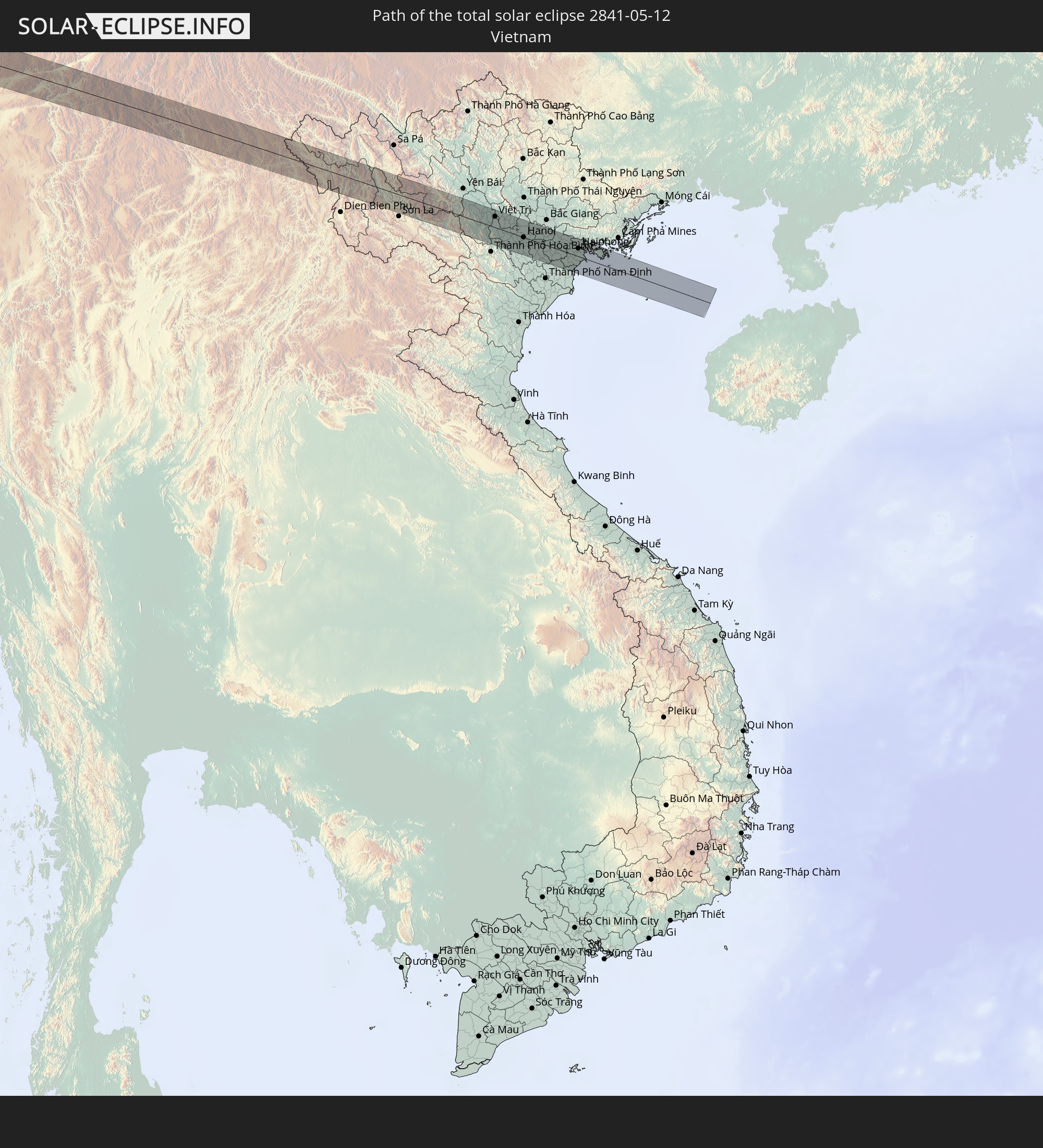 Vietnam
In den folgenden Ländern ist die Sonnenfinsternis partiell zu sehen
 Russland
 Kap Verde
 Senegal
 Mauretanien
 Gambia
 Guinea-Bissau
 Guinea
 St. Helena
 Sierra Leone
 Marokko
 Mali
Mali
 Liberia
 Algerien
 Elfenbeinküste
 Burkina Faso
 Frankreich
 Ghana
Ghana
 Togo
Togo
 Niger
Niger
 Benin
Benin
 Nigeria
 Äquatorialguinea
 São Tomé und Príncipe
 Italien
 Tunesien
 Kamerun
 Gabun
Gabun
 Libyen
 Republik Kongo
 Angola
 Namibia
 Demokratische Republik Kongo
 San Marino
 Vatikanstadt
 Slowenien
 Tschad
 Kroatien
 Polen
Polen
 Malta
Malta
 Zentralafrikanische Republik
 Bosnien und Herzegowina
 Ungarn
 Südafrika
 Slowakei
 Montenegro
 Serbien
 Albanien
 Griechenland
 Botswana
 Rumänien
 Mazedonien
 Sudan
Sudan
 Sambia
 Ukraine
 Bulgarien
 Weißrussland
 Ägypten
 Simbabwe
 Türkei
 Moldawien
 Lesotho
 Ruanda
 Burundi
 Tansania
 Uganda
 Mosambik
 Swasiland
 Republik Zypern
 Malawi
 Äthiopien
 Kenia
Kenia
 Staat Palästina
 Israel
 Saudi-Arabien
 Jordanien
 Libanon
 Syrien
 Eritrea
 Irak
Irak
 Georgien
 Französische Süd- und Antarktisgebiete
 Somalia
 Dschibuti
 Jemen
Jemen
 Madagaskar
 Komoren
 Armenien
 Iran
Iran
 Aserbaidschan
 Mayotte
 Seychellen
 Kasachstan
 Kuwait
 Bahrain
 Katar
Katar
 Vereinigte Arabische Emirate
 Oman
Oman
 Turkmenistan
 Usbekistan
 Afghanistan
 Pakistan
 Tadschikistan
 Indien
 Kirgisistan
 Malediven
 Volksrepublik China
 Sri Lanka
 Nepal
Nepal
 Mongolei
 Bangladesch
 Bhutan
 Myanmar
 Indonesien
 Thailand
 Malaysia
 Laos
Laos
 Vietnam
 Kambodscha
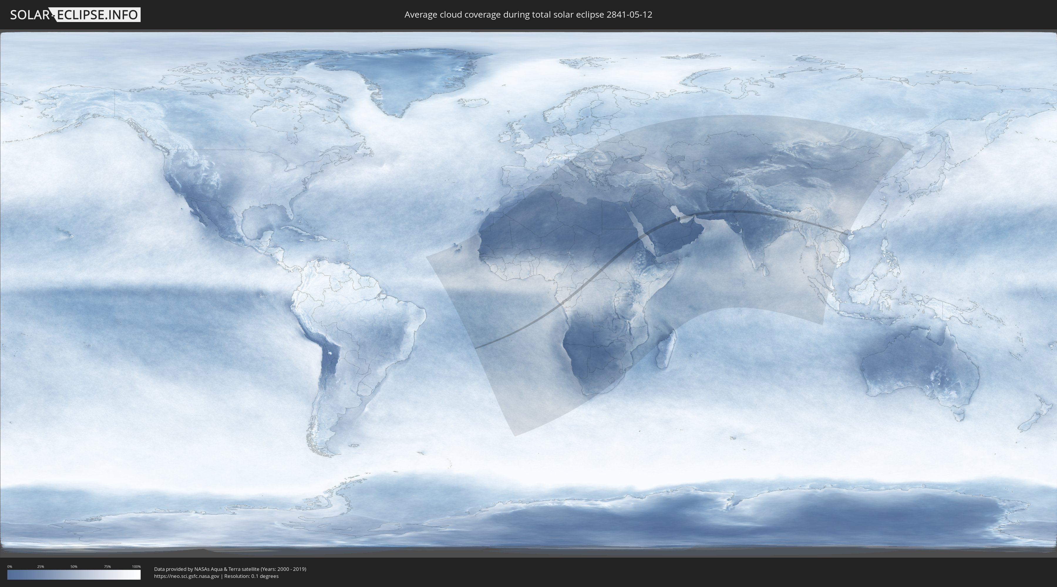
Wie wird das Wetter während der totalen Sonnenfinsternis am 12.05.2841?
Wo ist der beste Ort, um die totale Sonnenfinsternis vom 12.05.2841 zu beobachten?
Die folgenden Karten zeigen die durchschnittliche Bewölkung für den Tag, an dem die totale Sonnenfinsternis
stattfindet. Mit Hilfe der Karten lässt sich der Ort entlang des Finsternispfades eingrenzen,
der die besten Aussichen auf einen klaren wolkenfreien Himmel bietet.
Trotzdem muss man immer lokale Gegenenheiten beachten und sollte sich genau über das Wetter an seinem
gewählten Beobachtungsort informieren.
Die Daten stammen von den beiden NASA-Satelliten
AQUA und TERRA
und wurden über einen Zeitraum von 19 Jahren (2000 - 2019) gemittelt.

Detaillierte Länderkarten
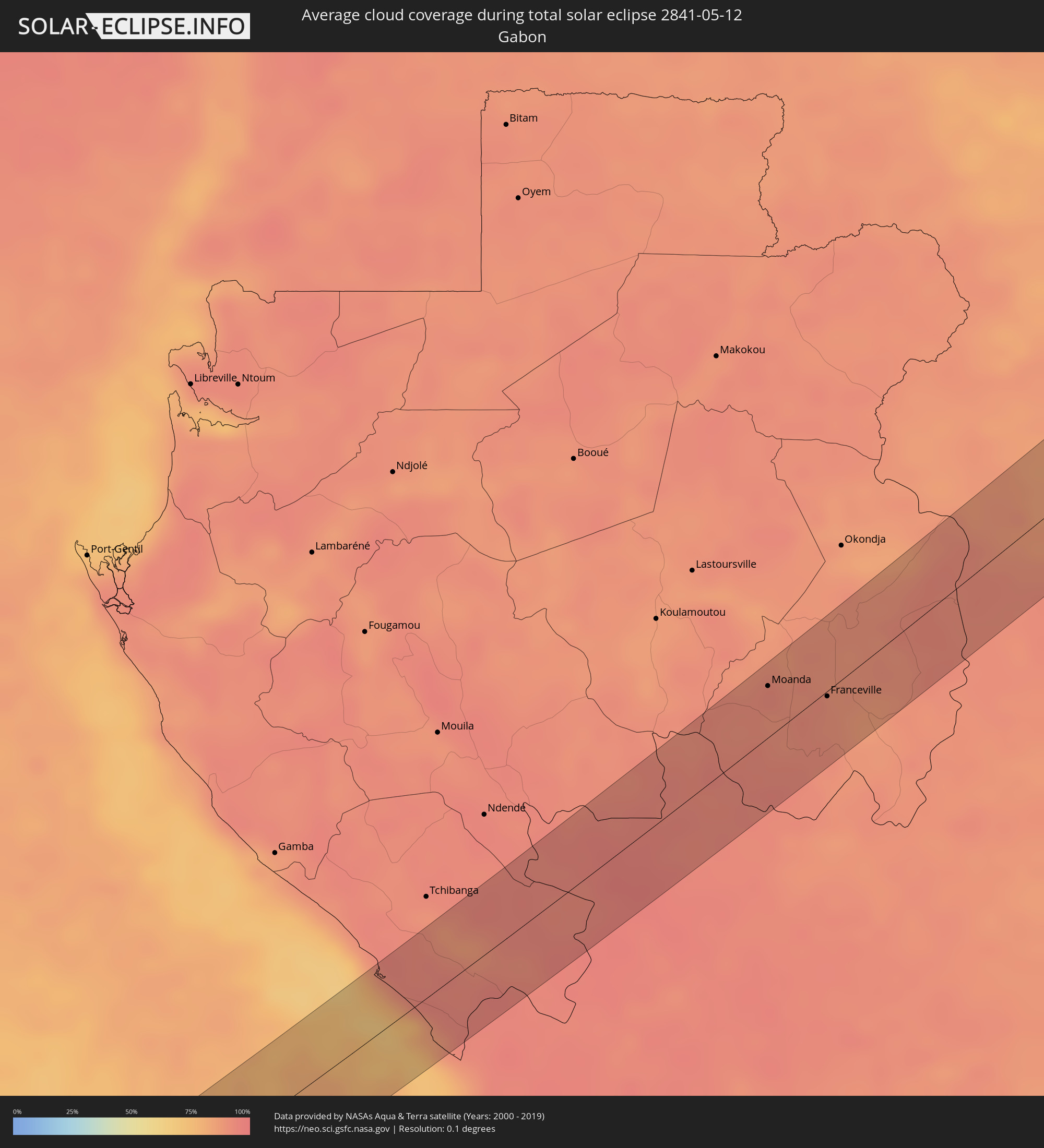 Gabun
Gabun
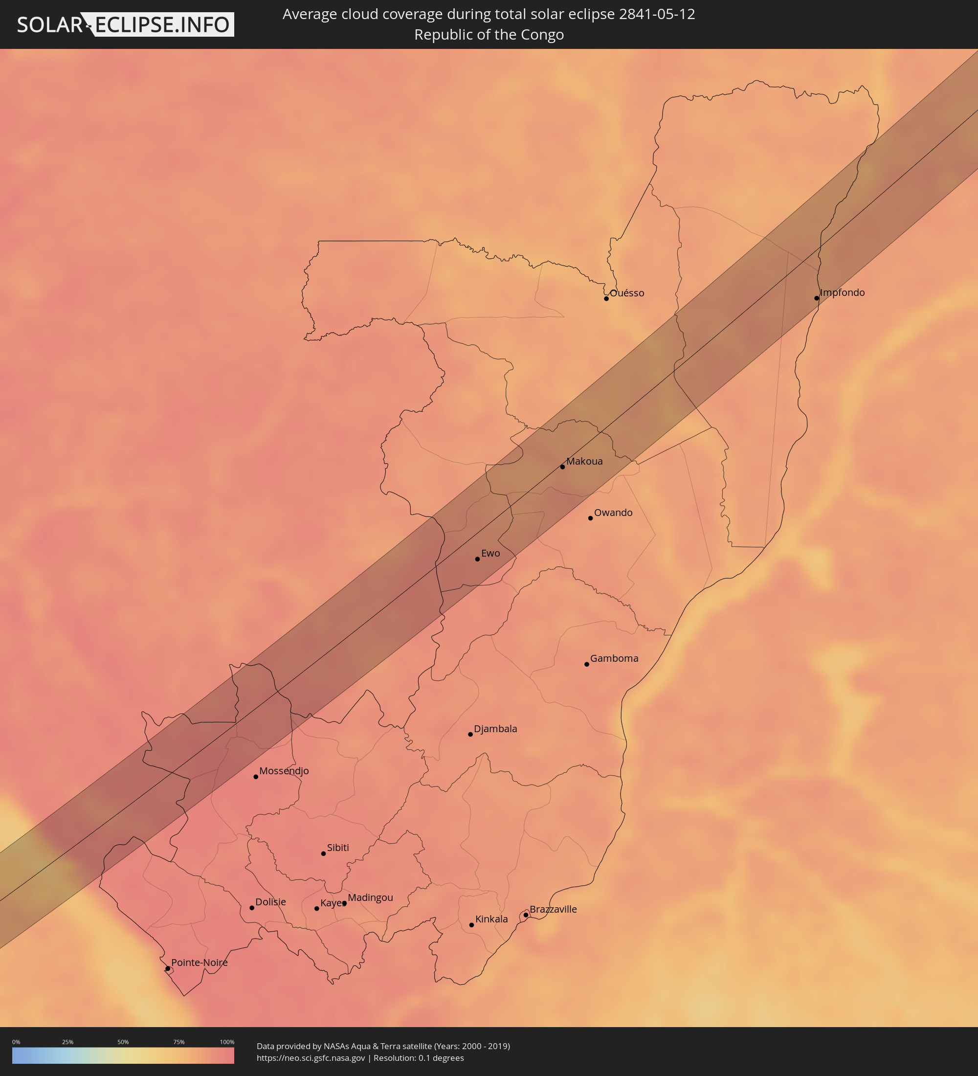 Republik Kongo
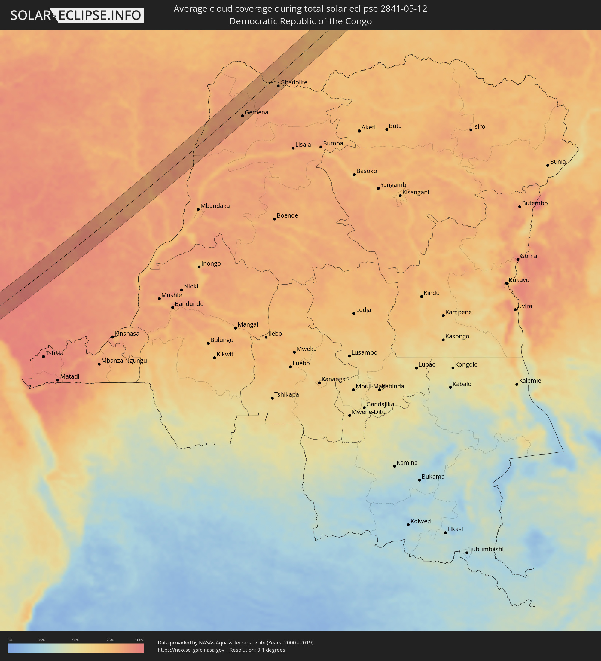 Demokratische Republik Kongo
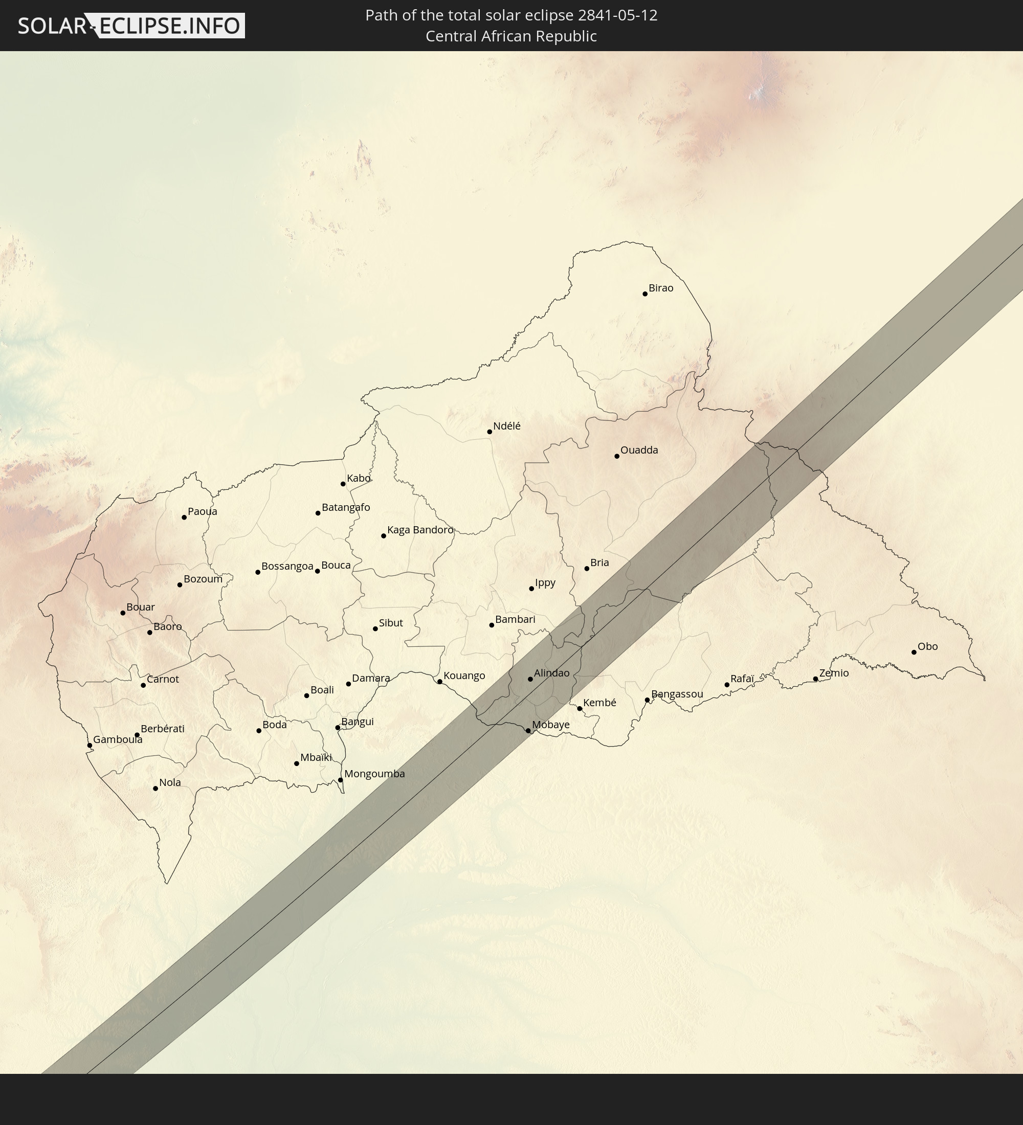
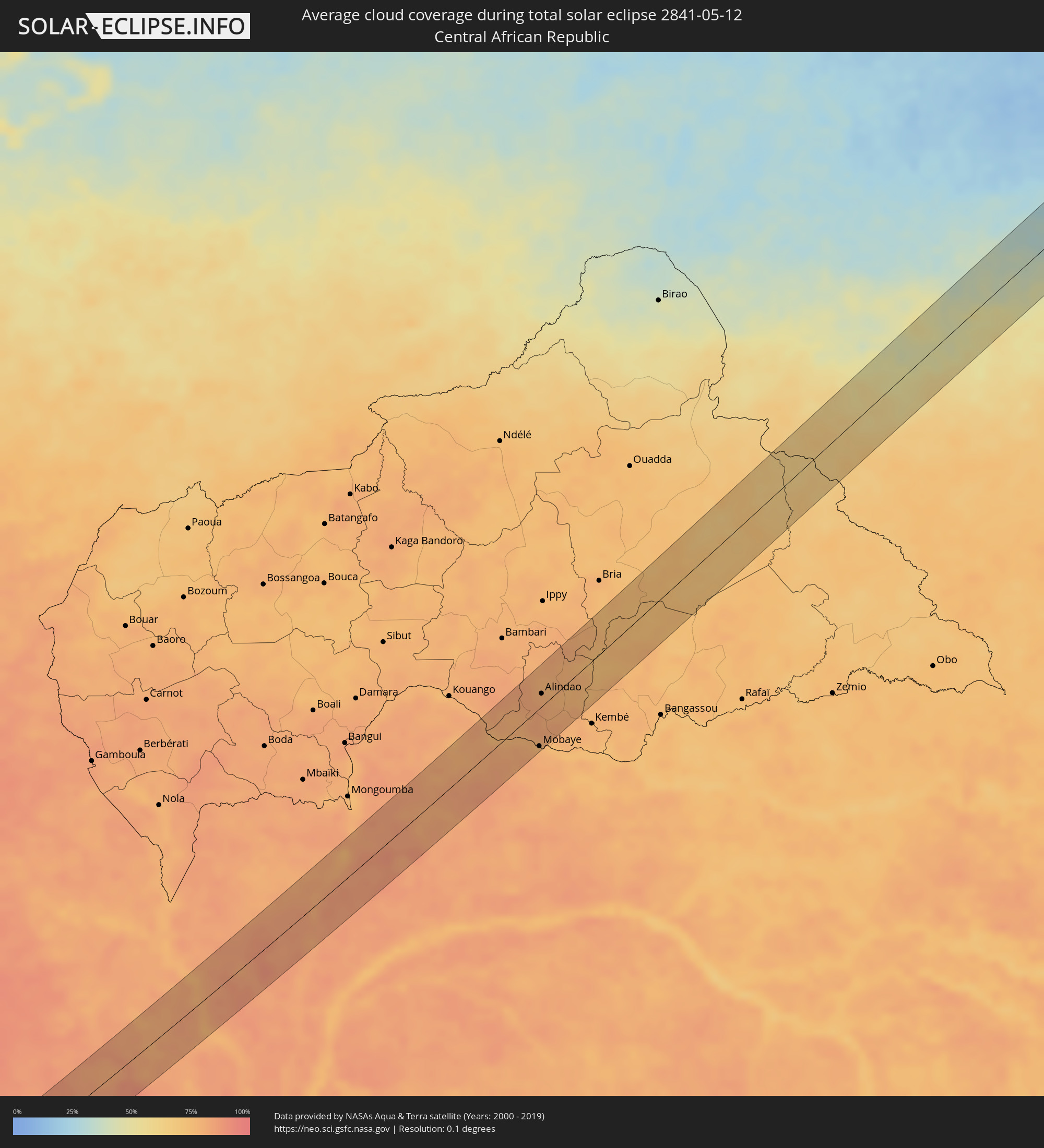 Zentralafrikanische Republik
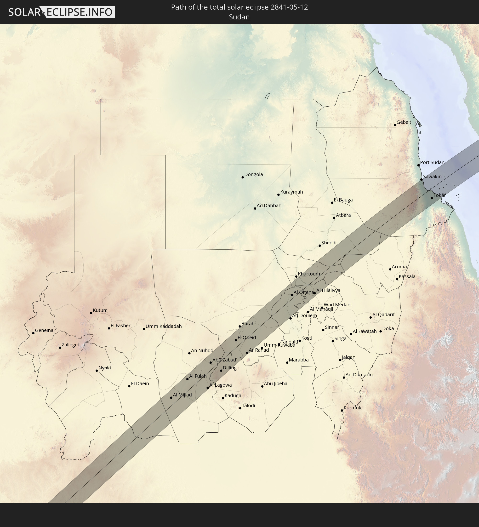
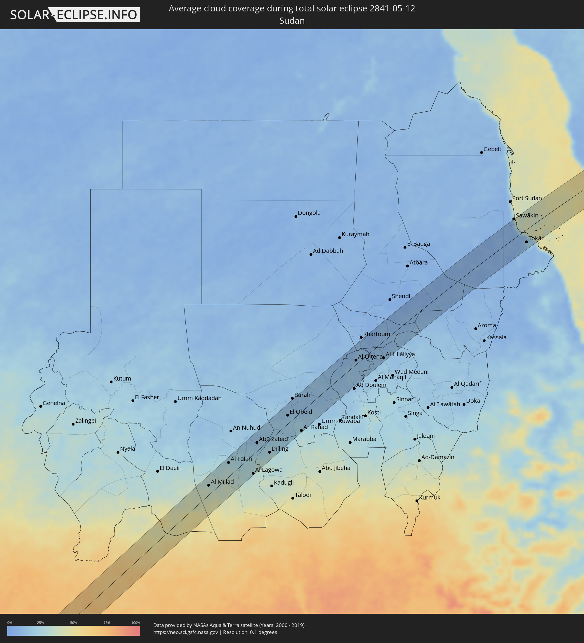 Sudan
Sudan
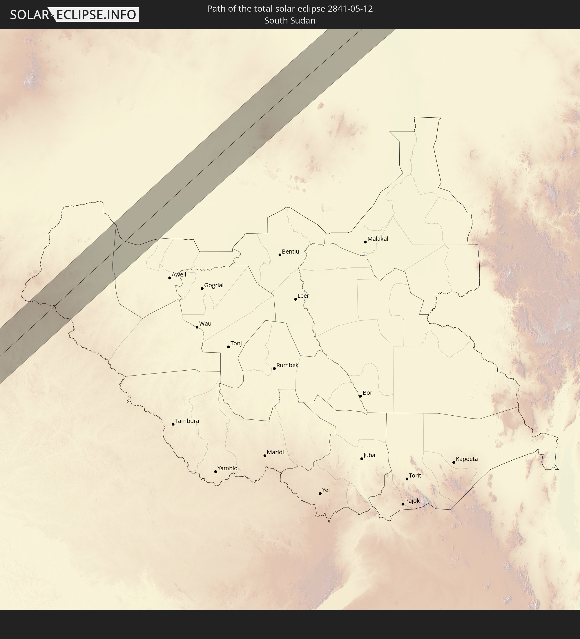
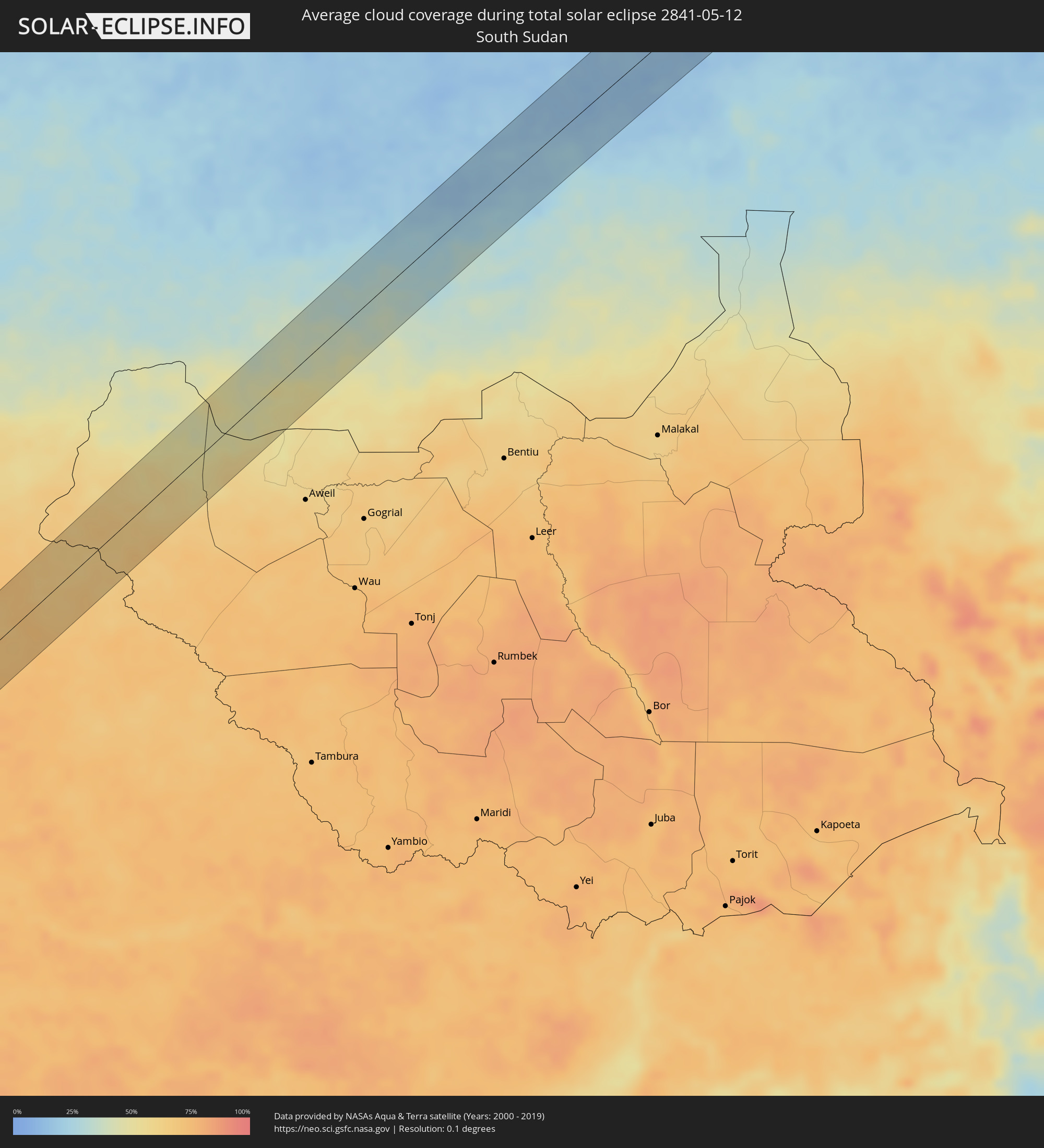 Südsudan
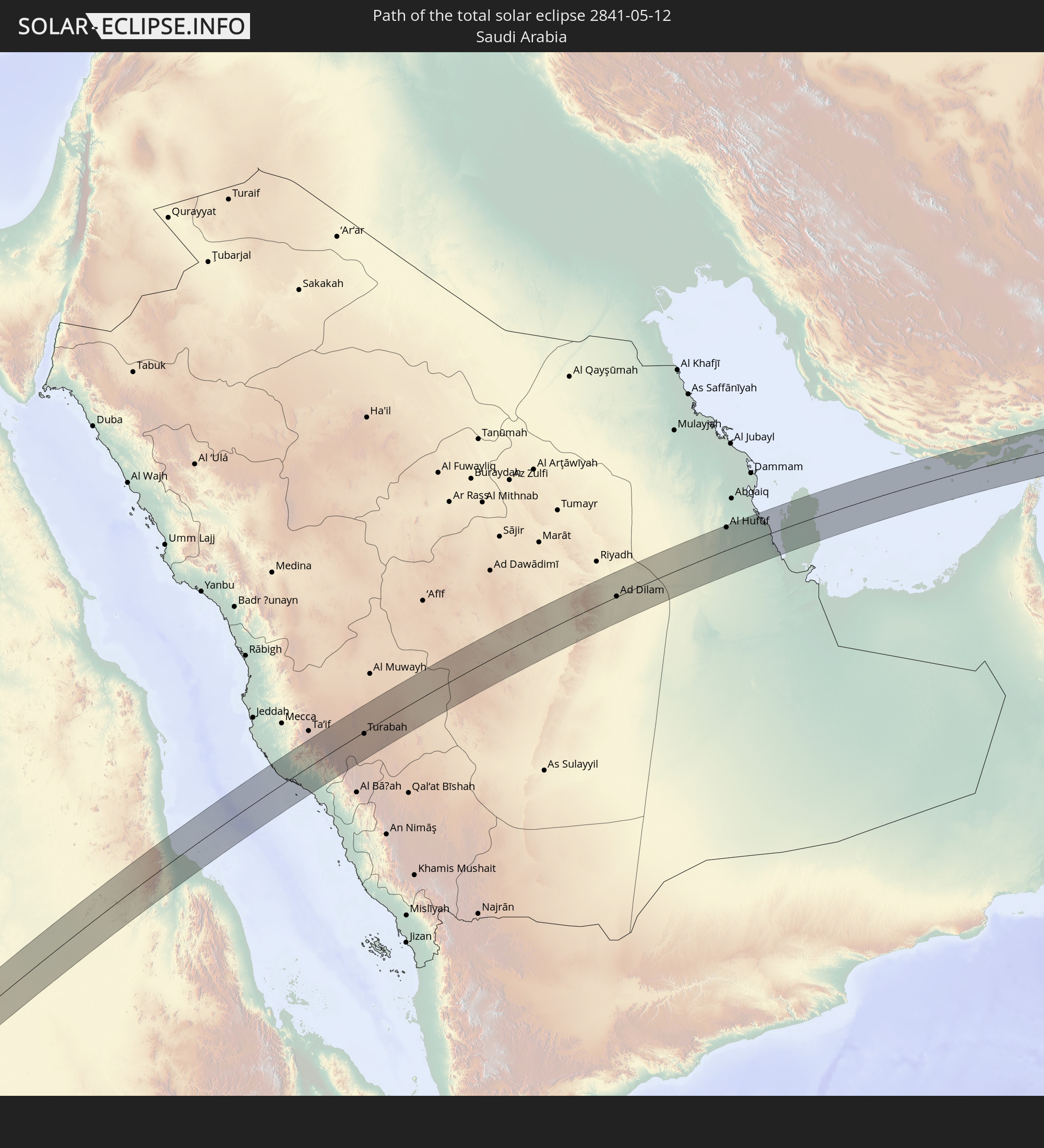
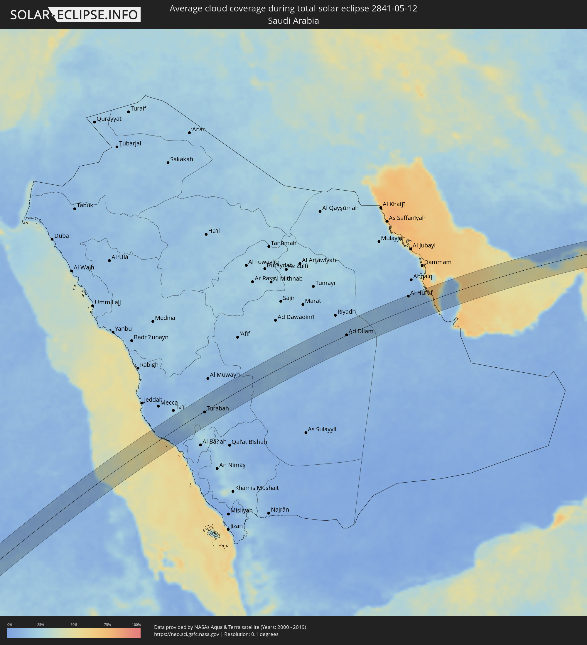 Saudi-Arabien
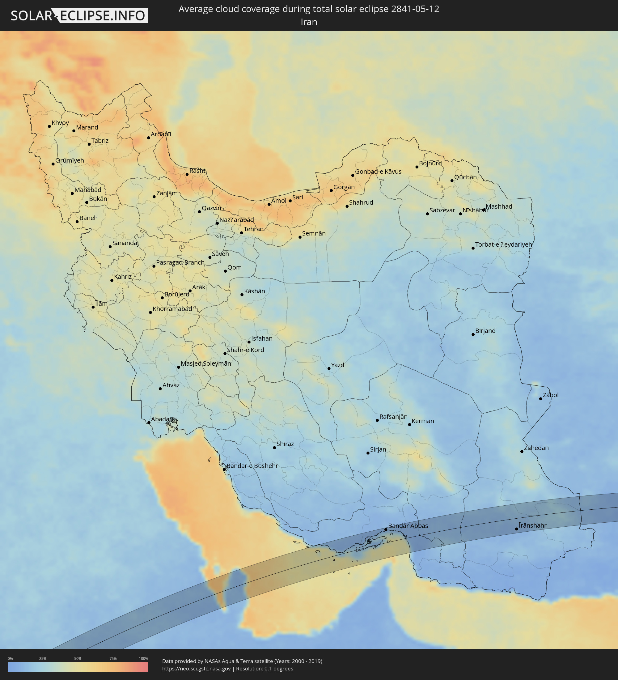 Iran
Iran
 Bahrain
 Katar
Katar
 Vereinigte Arabische Emirate
 Oman
Oman
 Pakistan
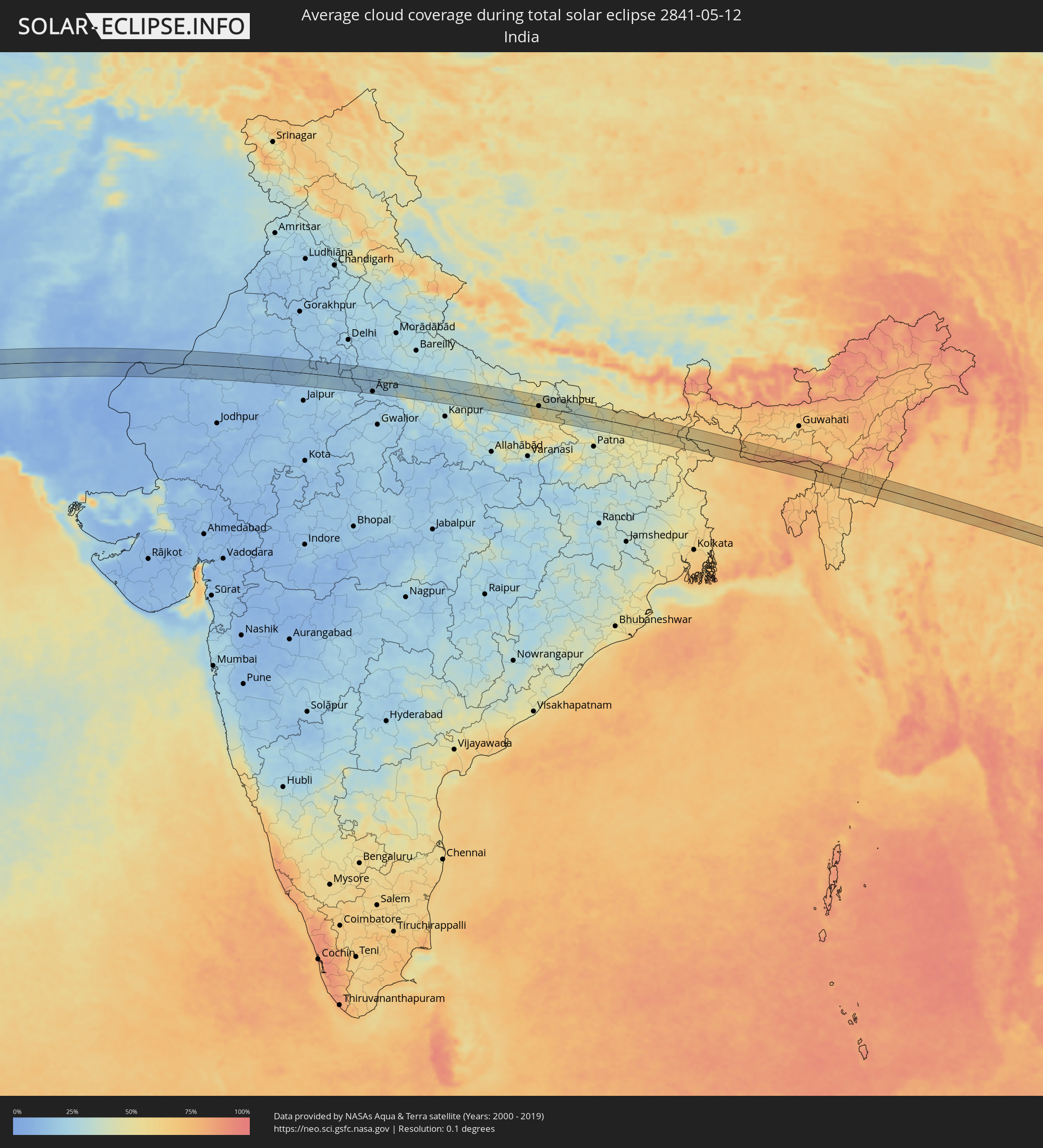 Indien
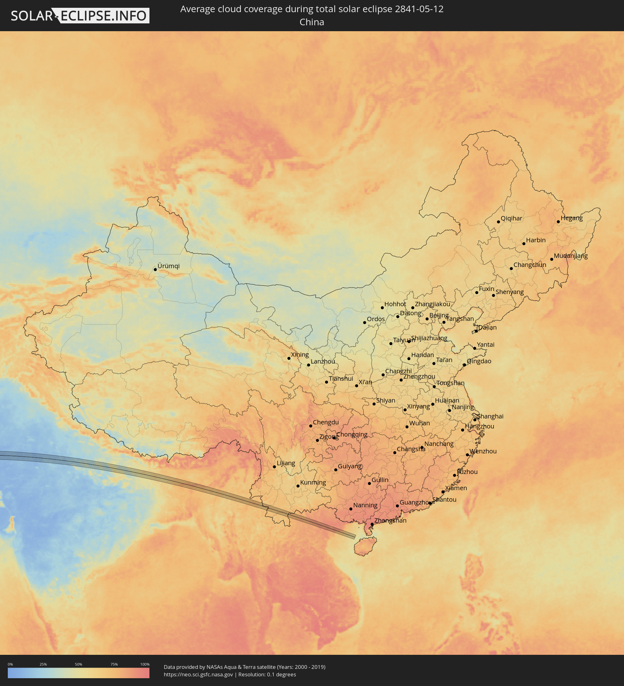 Volksrepublik China
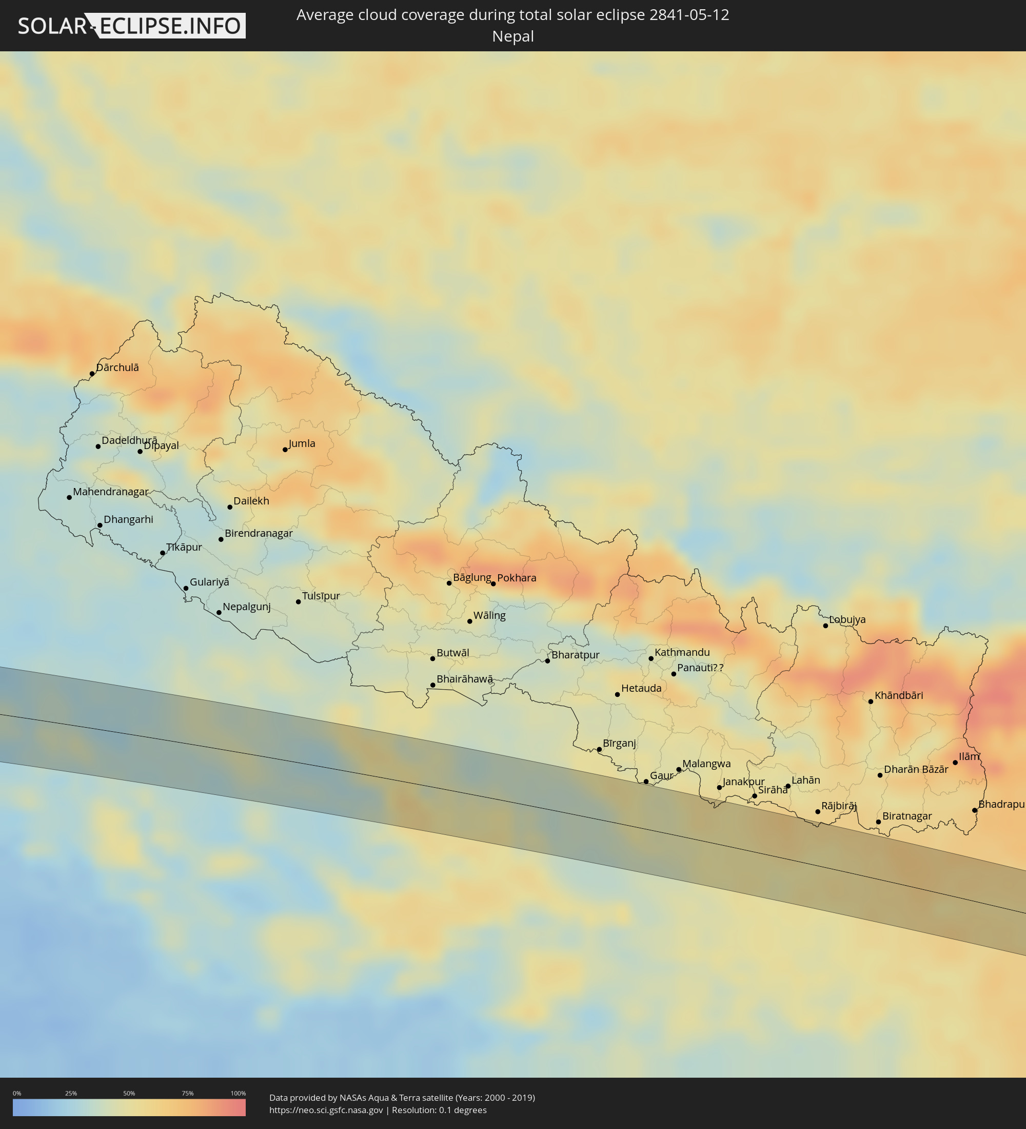 Nepal
Nepal
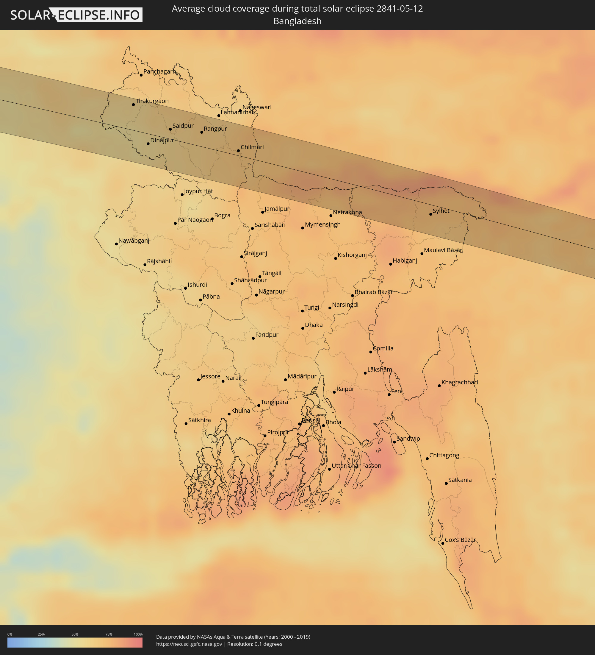 Bangladesch
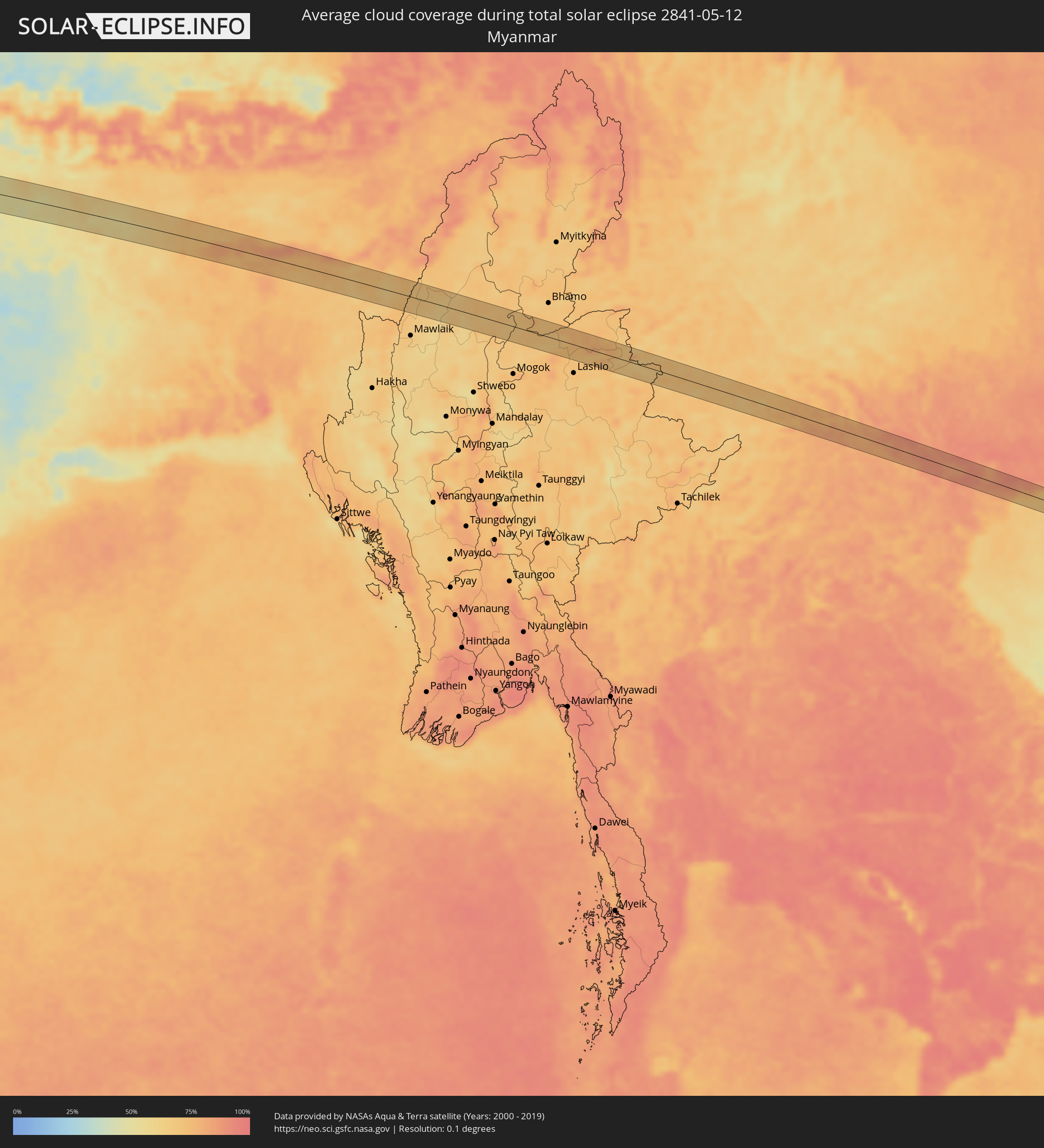 Myanmar
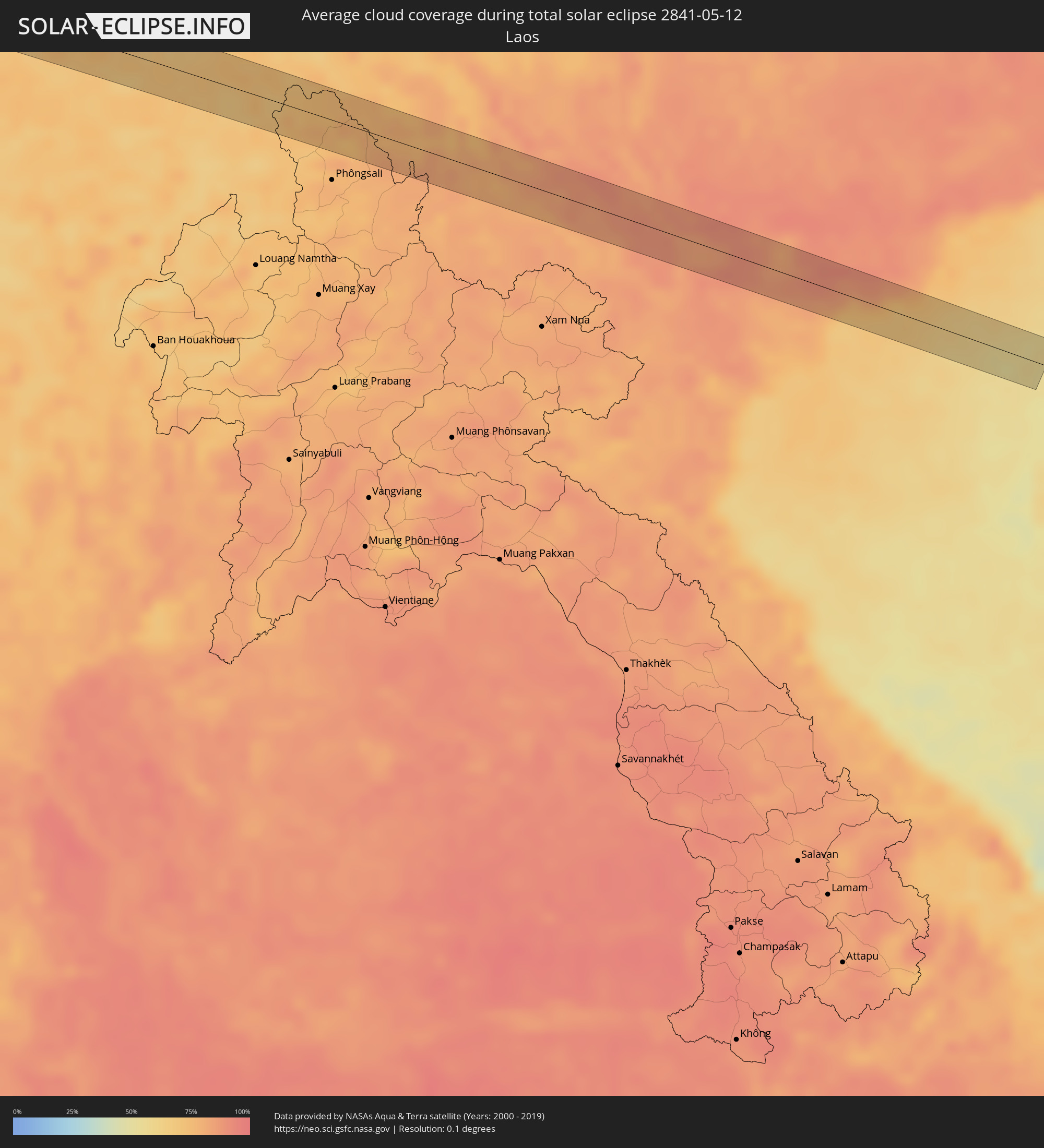 Laos
Laos
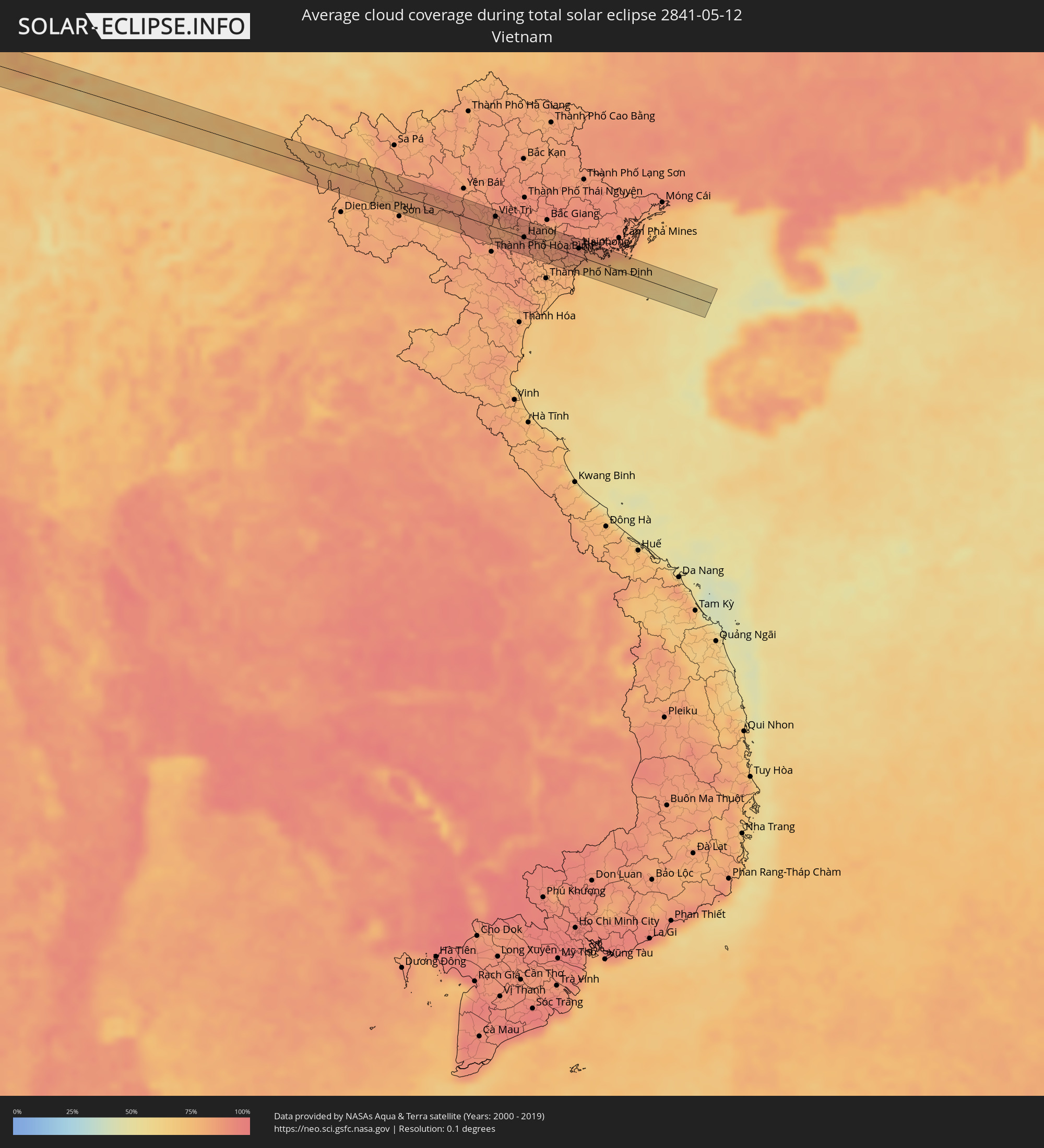 Vietnam
Orte im Finsternispfad
Die nachfolgene Tabelle zeigt Städte und Orte mit mehr als 5.000 Einwohnern, die sich im Finsternispfad befinden. Städte mit mehr als 100.000 Einwohnern sind dick gekennzeichnet. Mit einem Klick auf den Ort öffnet sich eine Detailkarte die die Lage des jeweiligen Ortes zusammen mit dem Verlauf der zentralen Finsternis präsentiert.
| Ort | Typ | Dauer der Verfinsterung | Ortszeit bei maximaler Verfinsterung | Entfernung zur Zentrallinie | Ø Bewölkung |
|
Moanda, Haut-Ogooué
|
total | - | 09:02:58 UTC+01:00 | 29 km | 90% |
|
Franceville, Haut-Ogooué
|
total | - | 09:03:18 UTC+01:00 | 3 km | 90% |
|
Ewo, Cuvette-Ouest
|
total | - | 09:05:42 UTC+01:00 | 23 km | 91% |
|
Makoua, Cuvette
|
total | - | 09:07:53 UTC+01:00 | 4 km | 88% |
|
Impfondo, Likouala
|
total | - | 09:13:19 UTC+01:00 | 40 km | 84% |
|
Gemena, Équateur
|
total | - | 09:18:15 UTC+01:00 | 27 km | 82% |
|
Bosobolo, Équateur
|
total | - | 09:19:56 UTC+01:00 | 43 km | 80% |
|
Gbadolite, Équateur
|
total | - | 09:21:43 UTC+01:00 | 32 km | 80% |
|
Mobaye, Basse-Kotto
|
total | - | 09:22:03 UTC+01:00 | 42 km | 79% |
|
Alindao, Basse-Kotto
|
total | - | 09:23:18 UTC+01:00 | 14 km | 80% |
|
Al Mijlad, West Kordofan State
|
total | - | 10:45:22 UTC+02:00 | 24 km | 37% |
|
El Fula, West Kordofan State
|
total | - | 10:47:51 UTC+02:00 | 35 km | 32% |
|
Al Fūlah, Southern Kordofan
|
total | - | 10:47:54 UTC+02:00 | 35 km | 31% |
|
Al Lagowa, West Kordofan State
|
total | - | 10:48:47 UTC+02:00 | 49 km | 29% |
|
Abū Zabad, West Kordofan State
|
total | - | 10:50:51 UTC+02:00 | 22 km | 19% |
|
Dilling, Southern Kordofan
|
total | - | 10:51:04 UTC+02:00 | 32 km | 28% |
|
El Obeid, North Kordofan
|
total | - | 10:54:24 UTC+02:00 | 21 km | 17% |
|
Ar Rahad, North Kordofan
|
total | - | 10:54:24 UTC+02:00 | 49 km | 28% |
|
Wad az Zāki, White Nile
|
total | - | 11:01:02 UTC+02:00 | 13 km | 18% |
|
Al Qiţena, White Nile
|
total | - | 11:02:10 UTC+02:00 | 10 km | 15% |
|
Wad Rāwah, Al Jazīrah
|
total | - | 11:04:24 UTC+02:00 | 18 km | 13% |
|
Al Hilāliyya, Al Jazīrah
|
total | - | 11:04:11 UTC+02:00 | 44 km | 16% |
|
Sawākin, Red Sea
|
total | - | 11:21:17 UTC+02:00 | 52 km | 10% |
|
Tokār, Red Sea
|
total | - | 11:21:00 UTC+02:00 | 34 km | 13% |
|
Turabah, Makkah
|
total | - | 12:35:11 UTC+03:00 | 4 km | 13% |
|
Ad Dilam, Ar Riyāḑ
|
total | - | 12:52:41 UTC+03:00 | 1 km | 12% |
|
Al Hufūf, Eastern Province
|
total | - | 13:00:01 UTC+03:00 | 46 km | 12% |
|
Al Mubarraz, Eastern Province
|
total | - | 13:00:06 UTC+03:00 | 51 km | 12% |
|
Al Baţţālīyah, Eastern Province
|
total | - | 13:00:15 UTC+03:00 | 51 km | 12% |
|
Al Jubayl, Eastern Province
|
total | - | 13:00:16 UTC+03:00 | 47 km | 13% |
|
Al Munayzilah, Eastern Province
|
total | - | 13:00:17 UTC+03:00 | 45 km | 13% |
|
Al Qārah, Eastern Province
|
total | - | 13:00:19 UTC+03:00 | 48 km | 13% |
|
Al Jafr, Eastern Province
|
total | - | 13:00:25 UTC+03:00 | 42 km | 13% |
|
Aţ Ţaraf, Eastern Province
|
total | - | 13:00:24 UTC+03:00 | 40 km | 13% |
|
Al Markaz, Eastern Province
|
total | - | 13:00:27 UTC+03:00 | 44 km | 13% |
|
Dukhān, Baladīyat ar Rayyān
|
total | - | 13:02:57 UTC+03:00 | 10 km | 28% |
|
Ash Shayḩānīyah, Baladīyat ar Rayyān
|
total | - | 13:03:57 UTC+03:00 | 11 km | 12% |
|
Umm Şalāl ‘Alī, Baladīyat Umm Şalāl
|
total | - | 13:04:27 UTC+03:00 | 7 km | 11% |
|
Umm Şalāl Muḩammad, Baladīyat Umm Şalāl
|
total | - | 13:04:25 UTC+03:00 | 13 km | 12% |
|
Ar Rayyān, Baladīyat ar Rayyān
|
total | - | 13:04:21 UTC+03:00 | 26 km | 11% |
|
Az̧ Z̧a‘āyin, Baladīyat az̧ Z̧a‘āyin
|
total | - | 13:04:45 UTC+03:00 | 2 km | 41% |
|
Al Khawr, Al Khawr
|
total | - | 13:04:54 UTC+03:00 | 12 km | 26% |
|
Doha, Baladīyat ad Dawḩah
|
total | - | 13:04:34 UTC+03:00 | 31 km | 15% |
|
Al Wukayr, Al Wakrah
|
total | - | 13:04:28 UTC+03:00 | 45 km | 14% |
|
Al Wakrah, Al Wakrah
|
total | - | 13:04:39 UTC+03:00 | 45 km | 34% |
|
Kīsh, Hormozgan
|
total | - | 13:41:24 UTC+03:30 | 30 km | 40% |
|
Bandar-e Lengeh, Hormozgan
|
total | - | 13:43:19 UTC+03:30 | 7 km | 32% |
|
Qeshm, Hormozgan
|
total | - | 13:46:38 UTC+03:30 | 16 km | 43% |
|
Bandar Abbas, Hormozgan
|
total | - | 13:46:48 UTC+03:30 | 42 km | 32% |
|
Mīnāb, Hormozgan
|
total | - | 13:48:30 UTC+03:30 | 18 km | 8% |
|
Īrānshahr, Sistan and Baluchestan
|
total | - | 13:56:00 UTC+03:30 | 37 km | 9% |
|
Khuzdār, Balochistān
|
total | - | 15:37:10 UTC+05:00 | 20 km | 18% |
|
Shahdād Kot, Sindh
|
total | - | 15:39:21 UTC+05:00 | 20 km | 8% |
|
Mehrābpur, Balochistān
|
total | - | 15:39:32 UTC+05:00 | 9 km | 10% |
|
Usta Muhammad, Balochistān
|
total | - | 15:39:34 UTC+05:00 | 17 km | 10% |
|
Ratodero, Sindh
|
total | - | 15:39:58 UTC+05:00 | 25 km | 17% |
|
Naudero, Sindh
|
total | - | 15:40:05 UTC+05:00 | 40 km | 11% |
|
Jacobābād, Sindh
|
total | - | 15:40:12 UTC+05:00 | 28 km | 10% |
|
Shikārpur, Sindh
|
total | - | 15:40:32 UTC+05:00 | 8 km | 14% |
|
Thul, Sindh
|
total | - | 15:40:44 UTC+05:00 | 23 km | 9% |
|
Sukkur, Sindh
|
total | - | 15:40:53 UTC+05:00 | 36 km | 13% |
|
Ghauspur, Sindh
|
total | - | 15:41:14 UTC+05:00 | 12 km | 16% |
|
Pāno Āqil, Sindh
|
total | - | 15:41:17 UTC+05:00 | 19 km | 16% |
|
Kandhkot, Sindh
|
total | - | 15:41:23 UTC+05:00 | 24 km | 16% |
|
Ghotki, Sindh
|
total | - | 15:41:36 UTC+05:00 | 3 km | 13% |
|
Mīrpur Mathelo, Sindh
|
total | - | 15:41:58 UTC+05:00 | 1 km | 14% |
|
Khairpur, Sindh
|
total | - | 15:42:12 UTC+05:00 | 4 km | 10% |
|
Sādiqābād, Punjab
|
total | - | 15:42:50 UTC+05:00 | 32 km | 6% |
|
Bīkaner, Rajasthan
|
total | - | 16:17:27 UTC+05:30 | 13 km | 12% |
|
Sūjāngarh, Rajasthan
|
total | - | 16:19:03 UTC+05:30 | 14 km | 16% |
|
Sīkar, Rajasthan
|
total | - | 16:19:57 UTC+05:30 | 18 km | 12% |
|
Alwar, Rajasthan
|
total | - | 16:21:48 UTC+05:30 | 8 km | 22% |
|
Bharatpur, Rajasthan
|
total | - | 16:22:54 UTC+05:30 | 37 km | 22% |
|
Mathura, Uttar Pradesh
|
total | - | 16:23:02 UTC+05:30 | 3 km | 19% |
|
Āgra, Uttar Pradesh
|
total | - | 16:23:31 UTC+05:30 | 34 km | 20% |
|
Fīrozābād, Uttar Pradesh
|
total | - | 16:23:57 UTC+05:30 | 33 km | 19% |
|
Farrukhābād, Uttar Pradesh
|
total | - | 16:25:10 UTC+05:30 | 10 km | 32% |
|
Lucknow, Uttar Pradesh
|
total | - | 16:26:43 UTC+05:30 | 31 km | 37% |
|
Fyzābād, Uttar Pradesh
|
total | - | 16:27:55 UTC+05:30 | 18 km | 34% |
|
Gorakhpur, Uttar Pradesh
|
total | - | 16:29:02 UTC+05:30 | 3 km | 40% |
|
Muzaffarpur, Bihar
|
total | - | 16:30:56 UTC+05:30 | 28 km | 42% |
|
Darbhanga, Bihar
|
total | - | 16:31:19 UTC+05:30 | 15 km | 49% |
|
Purnia, Bihar
|
total | - | 16:32:36 UTC+05:30 | 22 km | 55% |
|
Rāiganj, West Bengal
|
total | - | 16:33:06 UTC+05:30 | 25 km | 56% |
|
Pīrgaaj, Rangpur Division
|
total | - | 17:03:10 UTC+06:00 | 7 km | 53% |
|
Thākurgaon, Rangpur Division
|
total | - | 17:03:10 UTC+06:00 | 28 km | 58% |
|
Dinājpur, Rangpur Division
|
total | - | 17:03:26 UTC+06:00 | 12 km | 58% |
|
Saidpur, Rājshāhi
|
total | - | 17:03:32 UTC+06:00 | 11 km | 60% |
|
Parbatipur, Rangpur Division
|
total | - | 17:03:36 UTC+06:00 | 1 km | 61% |
|
Badarganj, Rangpur Division
|
total | - | 17:03:41 UTC+06:00 | 3 km | 64% |
|
Rangpur, Rangpur Division
|
total | - | 17:03:46 UTC+06:00 | 16 km | 65% |
|
Chilmāri, Rangpur Division
|
total | - | 17:04:06 UTC+06:00 | 5 km | 71% |
|
Chhātak, Sylhet
|
total | - | 17:05:25 UTC+06:00 | 1 km | 75% |
|
Sylhet, Sylhet
|
total | - | 17:05:34 UTC+06:00 | 11 km | 71% |
|
Silchar, Assam
|
total | - | 16:36:02 UTC+05:30 | 6 km | 72% |
|
Việt Trì, Phú Thọ
|
total | - | 18:10:11 UTC+07:00 | 16 km | 84% |
|
Sơn Tây, Ha Nội
|
total | - | 18:10:14 UTC+07:00 | 1 km | 88% |
|
Vĩnh Yên, Vĩnh Phúc
|
total | - | 18:10:11 UTC+07:00 | 22 km | 88% |
|
Hà Đông, Ha Nội
|
total | - | 18:10:17 UTC+07:00 | 8 km | 89% |
|
Hanoi, Ha Nội
|
total | - | 18:10:16 UTC+07:00 | 0 km | 89% |
|
Bắc Ninh, Bắc Ninh
|
total | - | 18:10:13 UTC+07:00 | 25 km | 86% |
|
Thành Phố Hải Dương, Hải Dương
|
total | - | 18:10:17 UTC+07:00 | 8 km | 87% |
|
Haiphong, Hải Phòng
|
total | - | 18:10:18 UTC+07:00 | 12 km | 87% |
|
Cát Bà, Hải Phòng
|
total | - | 18:10:20 UTC+07:00 | 10 km | 73% |