Totale Sonnenfinsternis vom 05.08.2920
| Wochentag: | Montag |
| Maximale Dauer der Verfinsterung: | 04m48s |
| Maximale Breite des Finsternispfades: | 248 km |
| Saroszyklus: | 160 |
| Bedeckungsgrad: | 100% |
| Magnitude: | 1.066 |
| Gamma: | 0.4991 |
Wo kann man die Sonnenfinsternis vom 05.08.2920 sehen?
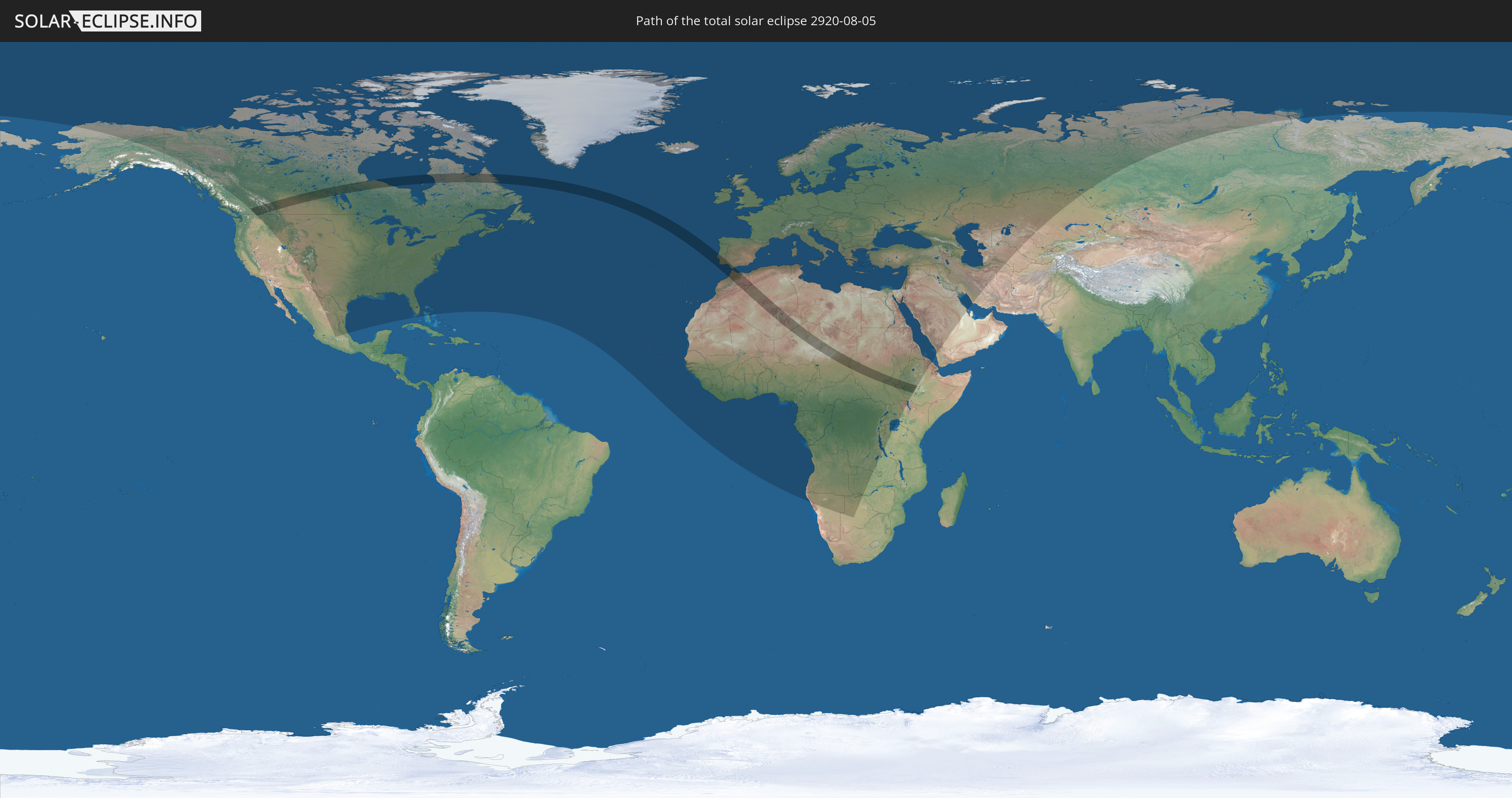
Die Sonnenfinsternis am 05.08.2920 kann man in 118 Ländern als partielle Sonnenfinsternis beobachten.
Der Finsternispfad verläuft durch 12 Länder. Nur in diesen Ländern ist sie als totale Sonnenfinsternis zu sehen.
In den folgenden Ländern ist die Sonnenfinsternis total zu sehen
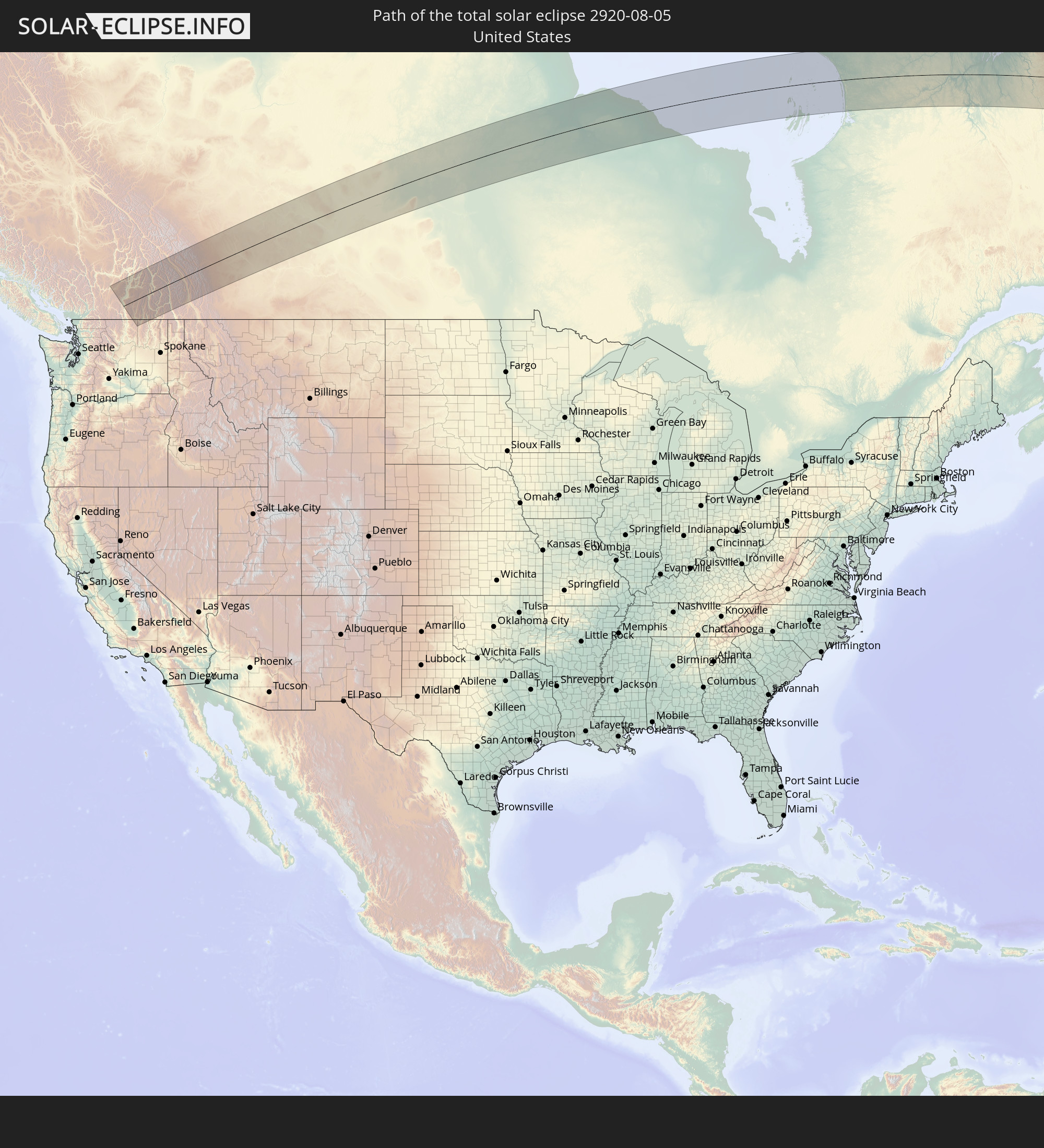 Vereinigte Staaten
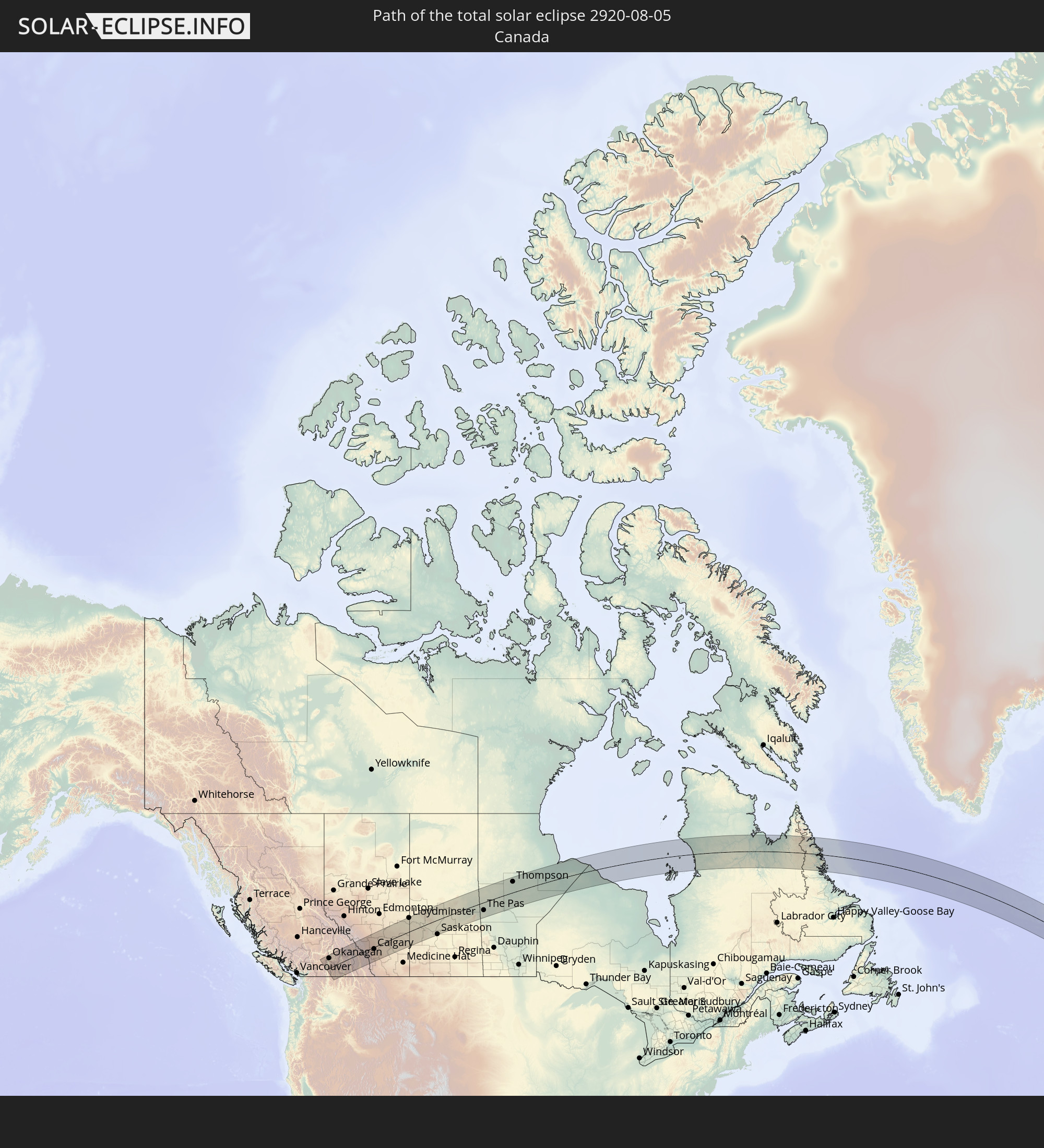 Kanada
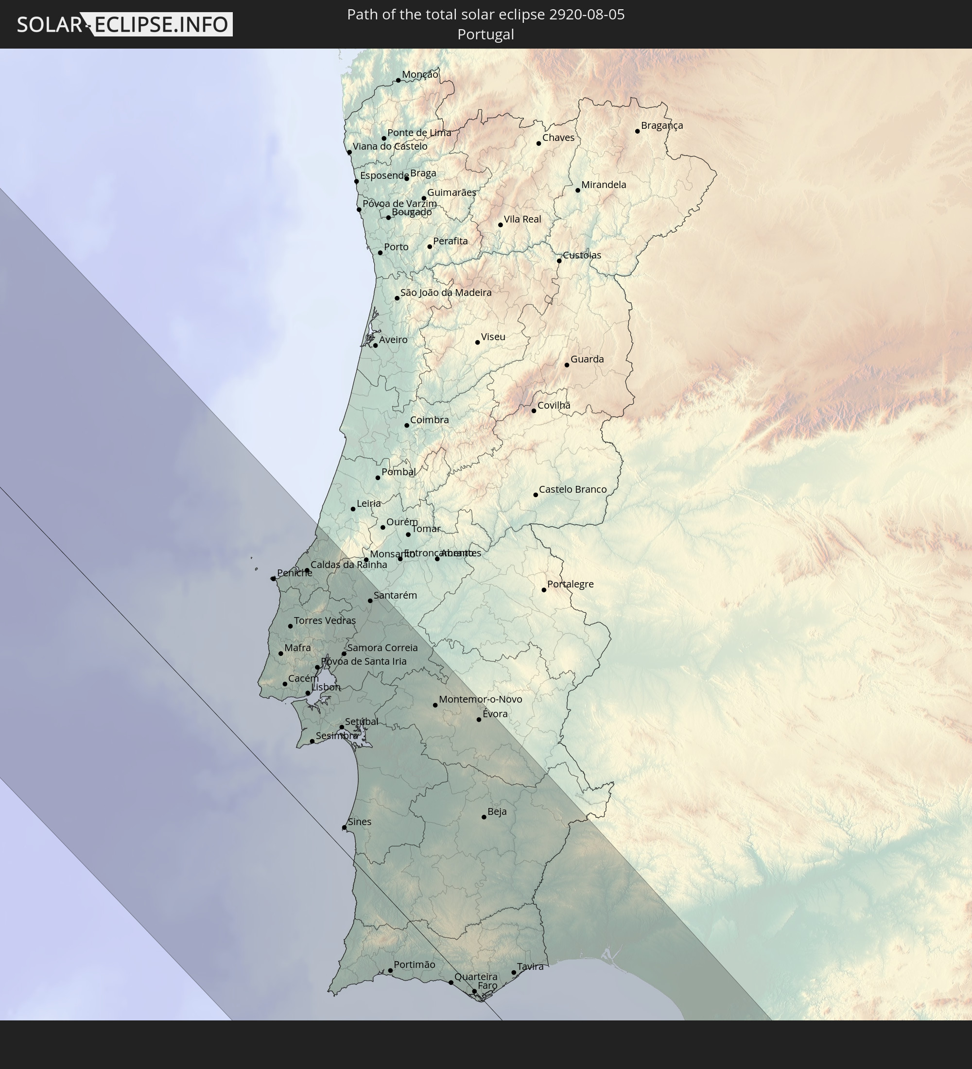 Portugal
 Spanien
 Marokko
 Algerien
 Gibraltar
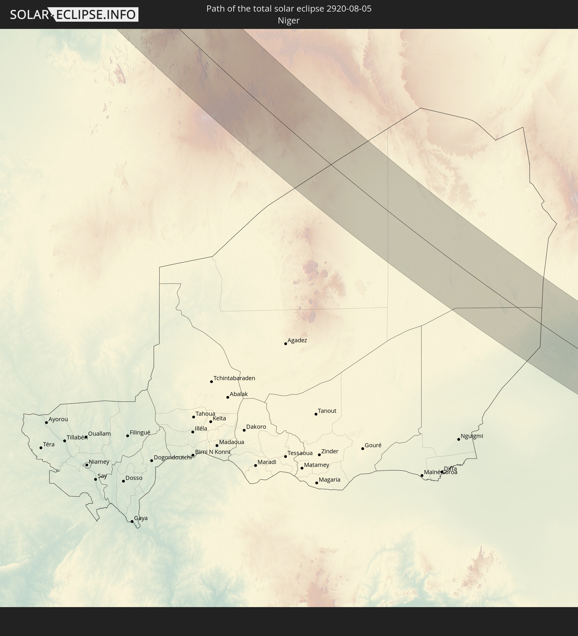 Niger
Niger
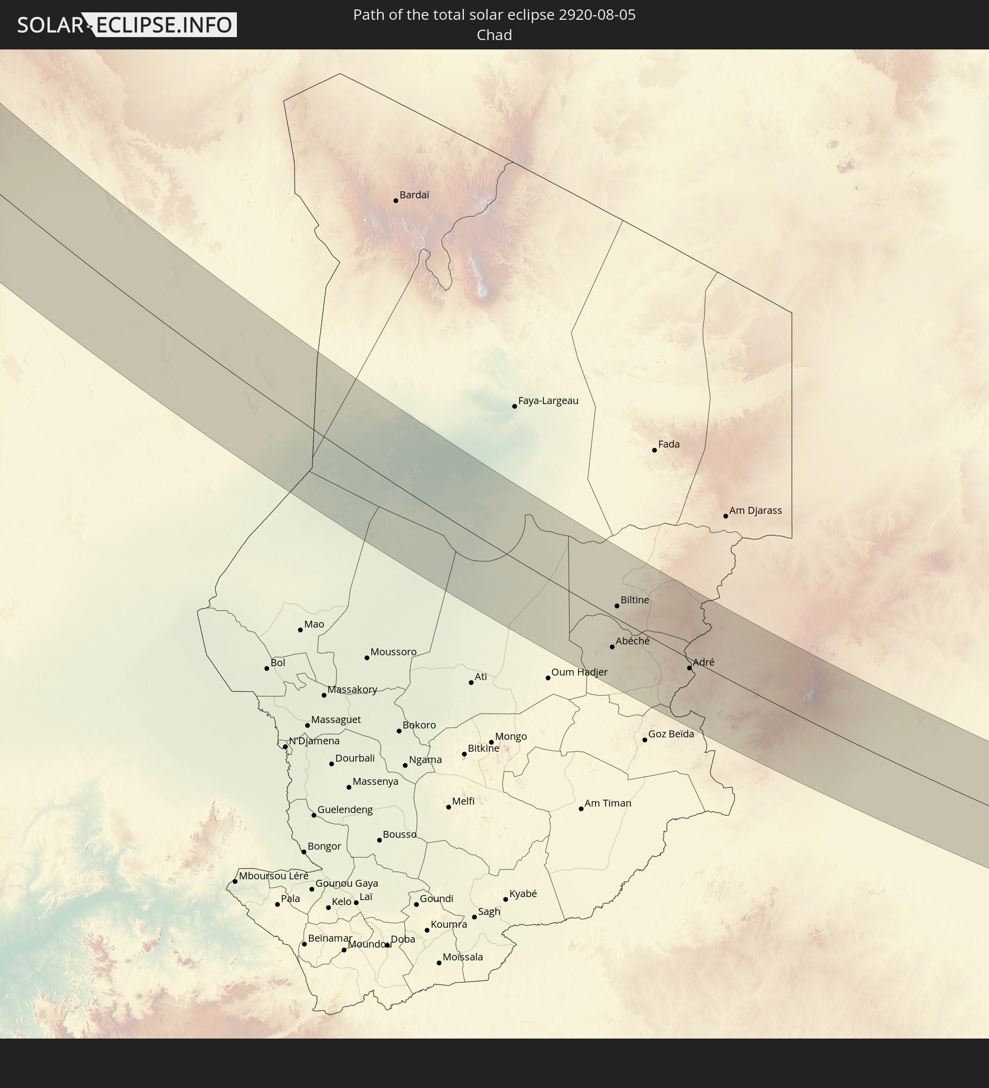 Tschad
 Sudan
Sudan
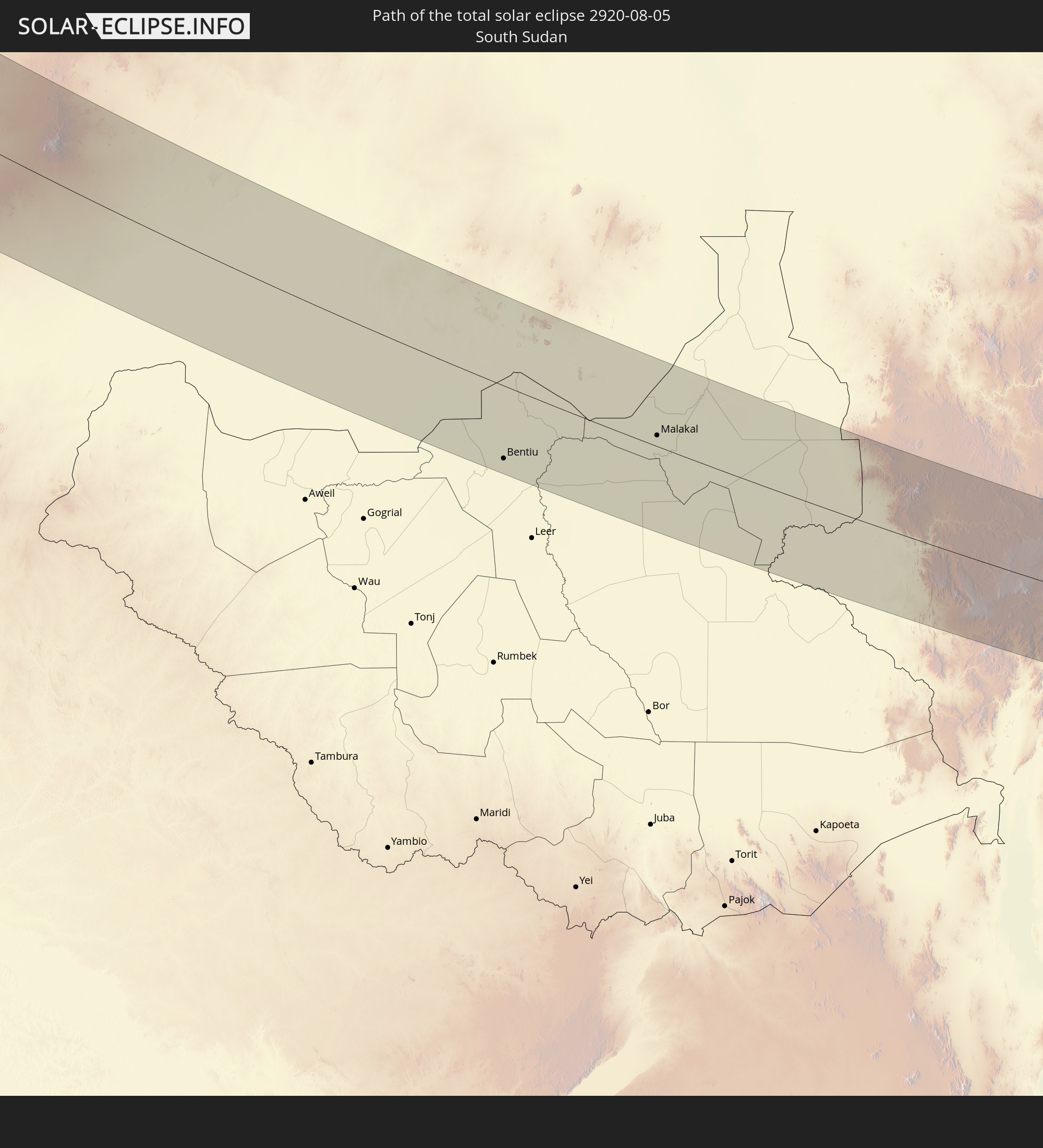 Südsudan
 Äthiopien
In den folgenden Ländern ist die Sonnenfinsternis partiell zu sehen
 Russland
 Vereinigte Staaten
 Kanada
 Mexiko
 Grönland
 Bahamas
 Bermuda
 Saint-Pierre und Miquelon
 Portugal
 Kap Verde
 Island
 Spanien
 Senegal
 Mauretanien
 Gambia
 Guinea-Bissau
 Guinea
 Sierra Leone
 Marokko
 Mali
Mali
 Liberia
 Irland
 Spitzbergen
 Algerien
 Vereinigtes Königreich
 Elfenbeinküste
 Färöer
 Burkina Faso
 Gibraltar
 Frankreich
 Isle of Man
 Ghana
Ghana
 Guernsey
 Jersey
 Togo
Togo
 Niger
Niger
 Benin
Benin
 Andorra
 Belgien
 Nigeria
 Niederlande
 Norwegen
 Äquatorialguinea
 Luxemburg
 Deutschland
 Schweiz
 São Tomé und Príncipe
 Italien
 Monaco
 Tunesien
 Dänemark
 Kamerun
 Gabun
Gabun
 Libyen
 Liechtenstein
 Österreich
 Schweden
 Republik Kongo
 Angola
 Namibia
 Tschechien
 Demokratische Republik Kongo
 San Marino
 Vatikanstadt
 Slowenien
 Tschad
 Kroatien
 Polen
Polen
 Malta
Malta
 Zentralafrikanische Republik
 Bosnien und Herzegowina
 Ungarn
 Slowakei
 Montenegro
 Serbien
 Albanien
 Åland Islands
 Griechenland
 Botswana
 Rumänien
 Mazedonien
 Finnland
 Litauen
 Lettland
 Estland
 Sudan
Sudan
 Sambia
 Ukraine
 Bulgarien
 Weißrussland
 Ägypten
 Simbabwe
 Türkei
 Moldawien
 Ruanda
 Burundi
 Tansania
 Uganda
 Republik Zypern
 Äthiopien
 Kenia
Kenia
 Staat Palästina
 Israel
 Saudi-Arabien
 Jordanien
 Libanon
 Syrien
 Eritrea
 Irak
Irak
 Georgien
 Jemen
Jemen
 Armenien
 Iran
Iran
 Aserbaidschan
 Kasachstan
 Kuwait
 Turkmenistan
 Usbekistan
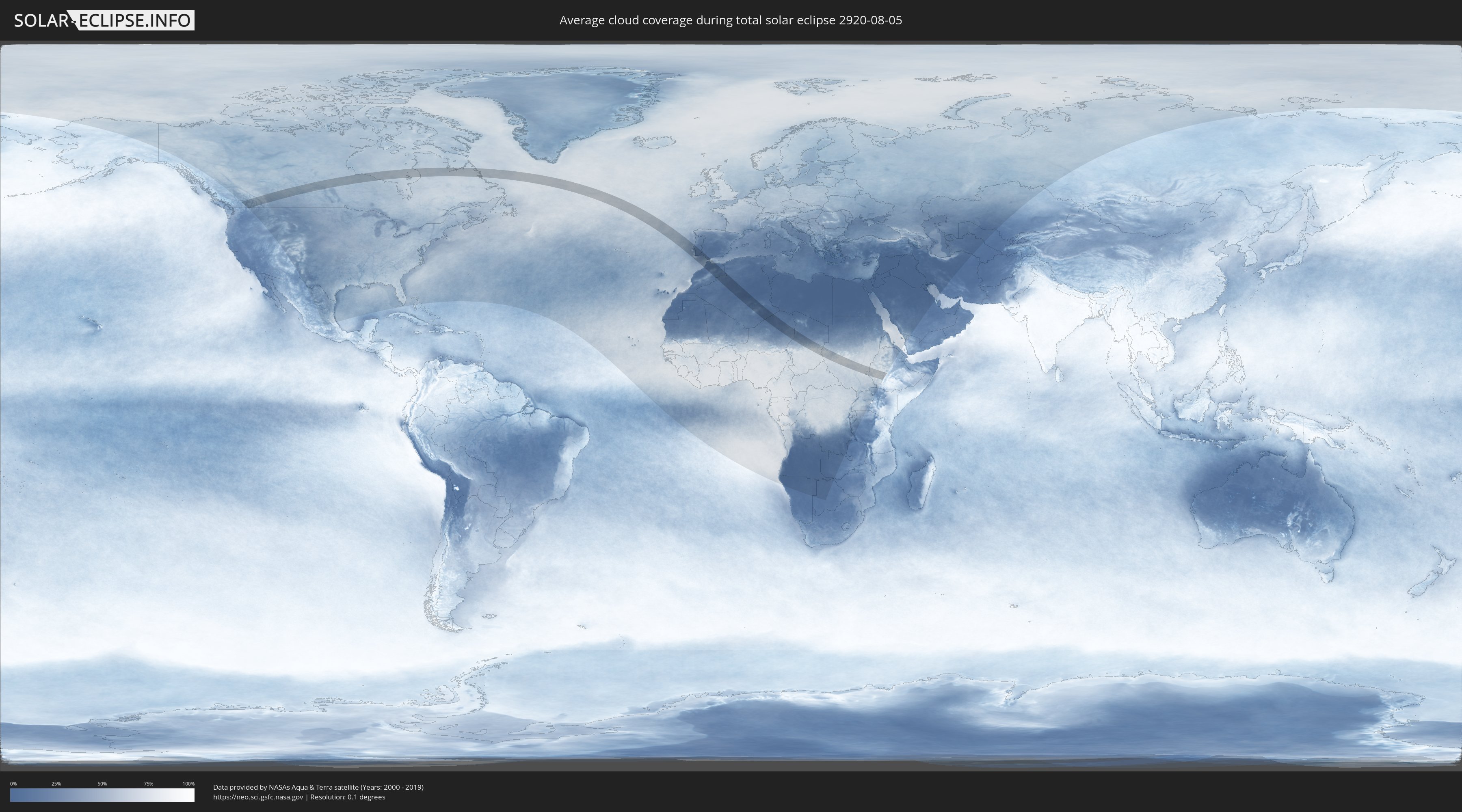
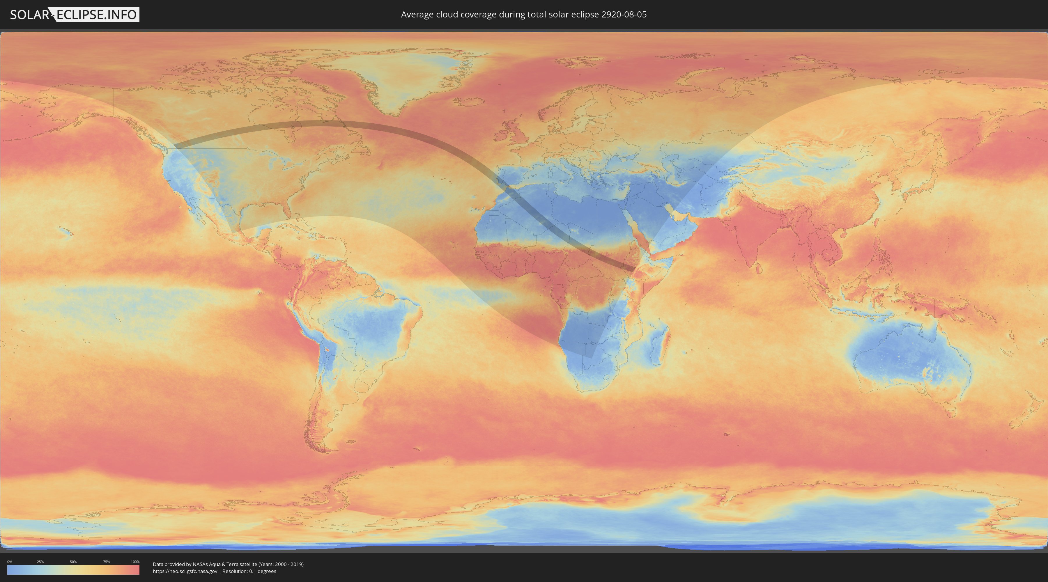
Wie wird das Wetter während der totalen Sonnenfinsternis am 05.08.2920?
Wo ist der beste Ort, um die totale Sonnenfinsternis vom 05.08.2920 zu beobachten?
Die folgenden Karten zeigen die durchschnittliche Bewölkung für den Tag, an dem die totale Sonnenfinsternis
stattfindet. Mit Hilfe der Karten lässt sich der Ort entlang des Finsternispfades eingrenzen,
der die besten Aussichen auf einen klaren wolkenfreien Himmel bietet.
Trotzdem muss man immer lokale Gegenenheiten beachten und sollte sich genau über das Wetter an seinem
gewählten Beobachtungsort informieren.
Die Daten stammen von den beiden NASA-Satelliten
AQUA und TERRA
und wurden über einen Zeitraum von 19 Jahren (2000 - 2019) gemittelt.
Detaillierte Länderkarten
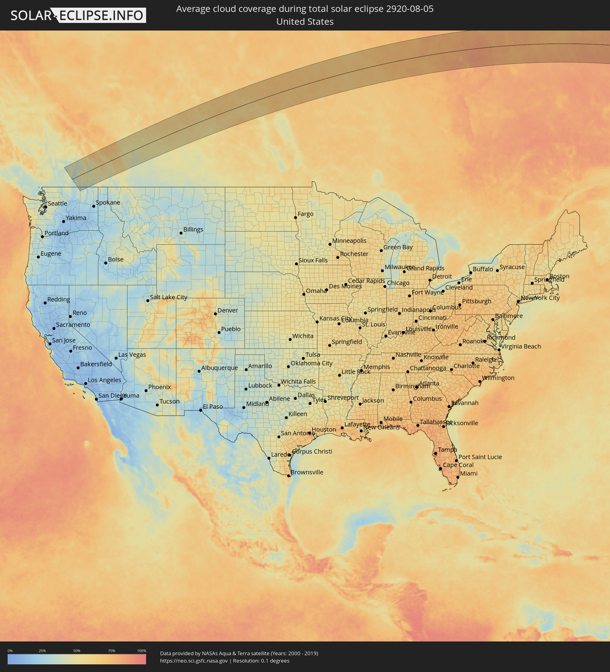 Vereinigte Staaten
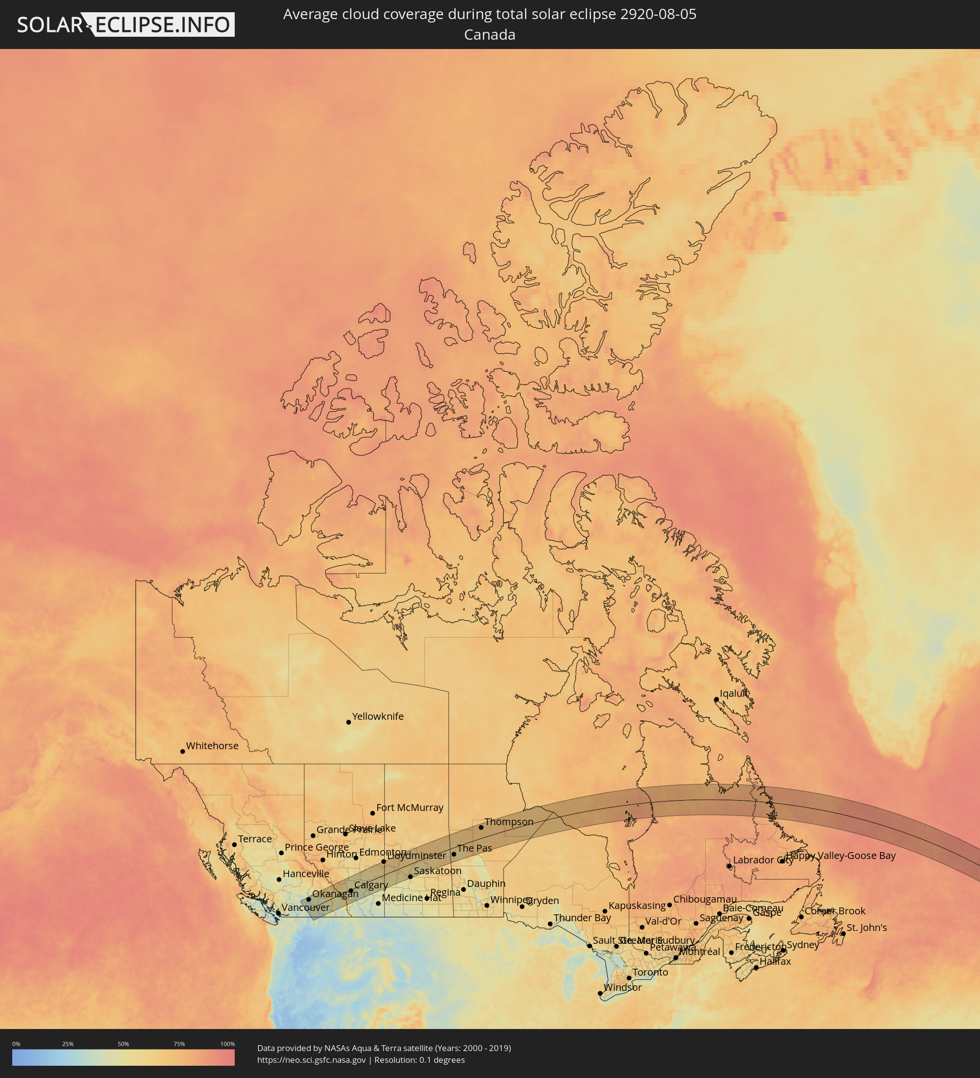 Kanada
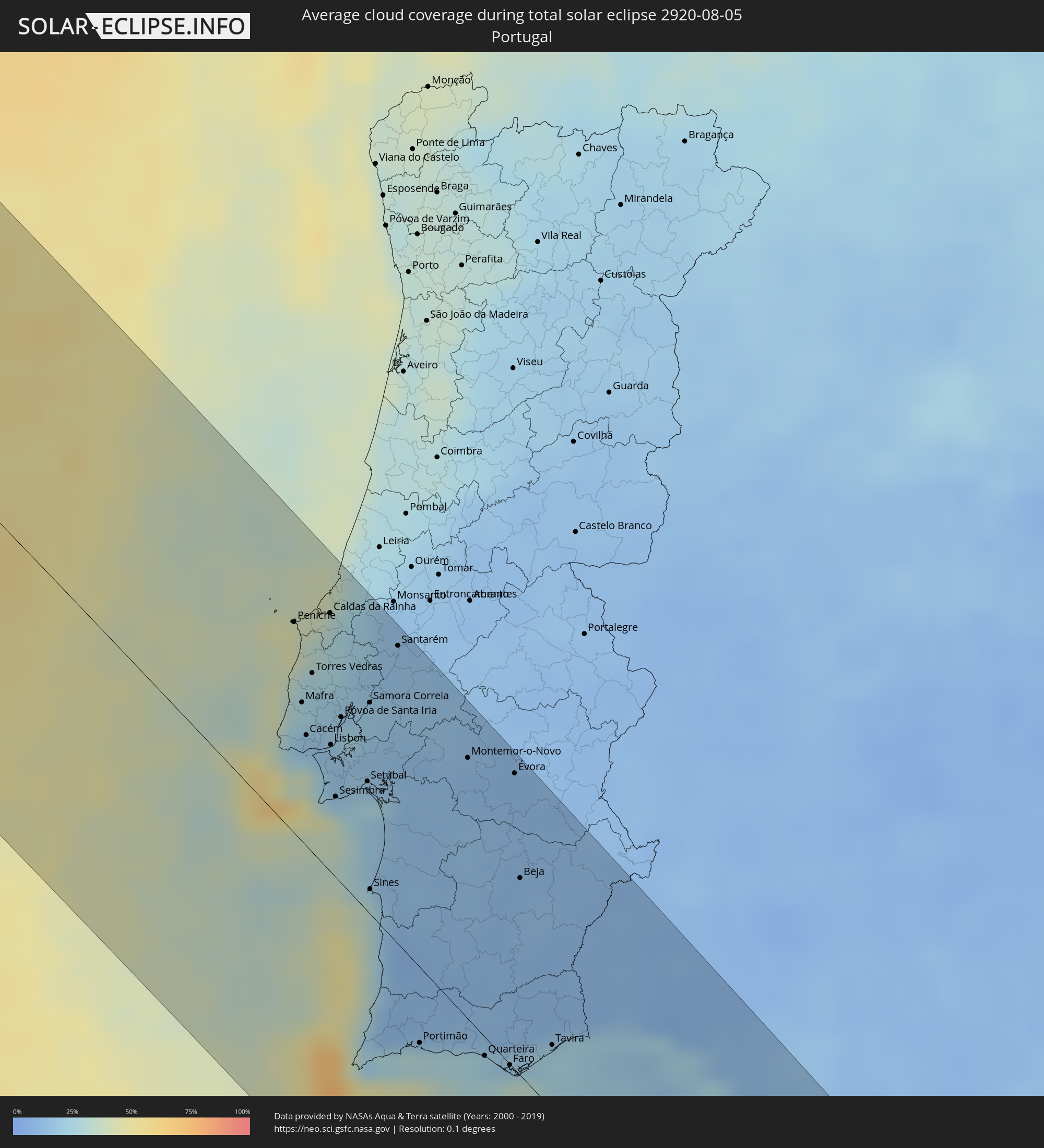 Portugal
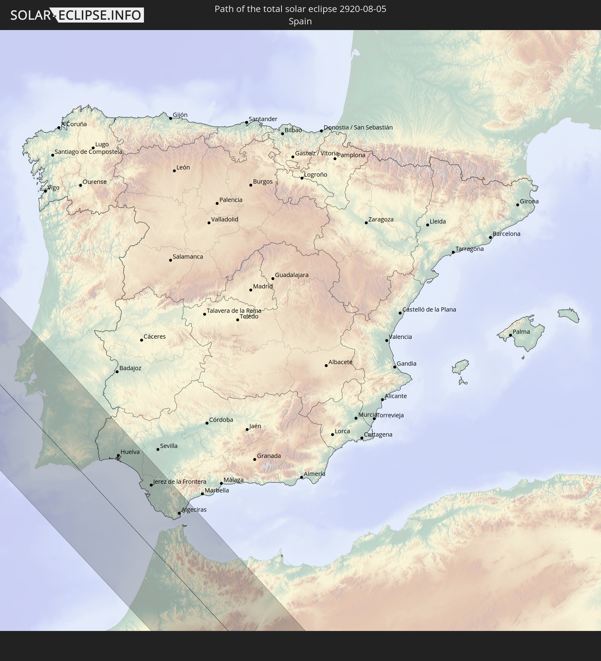
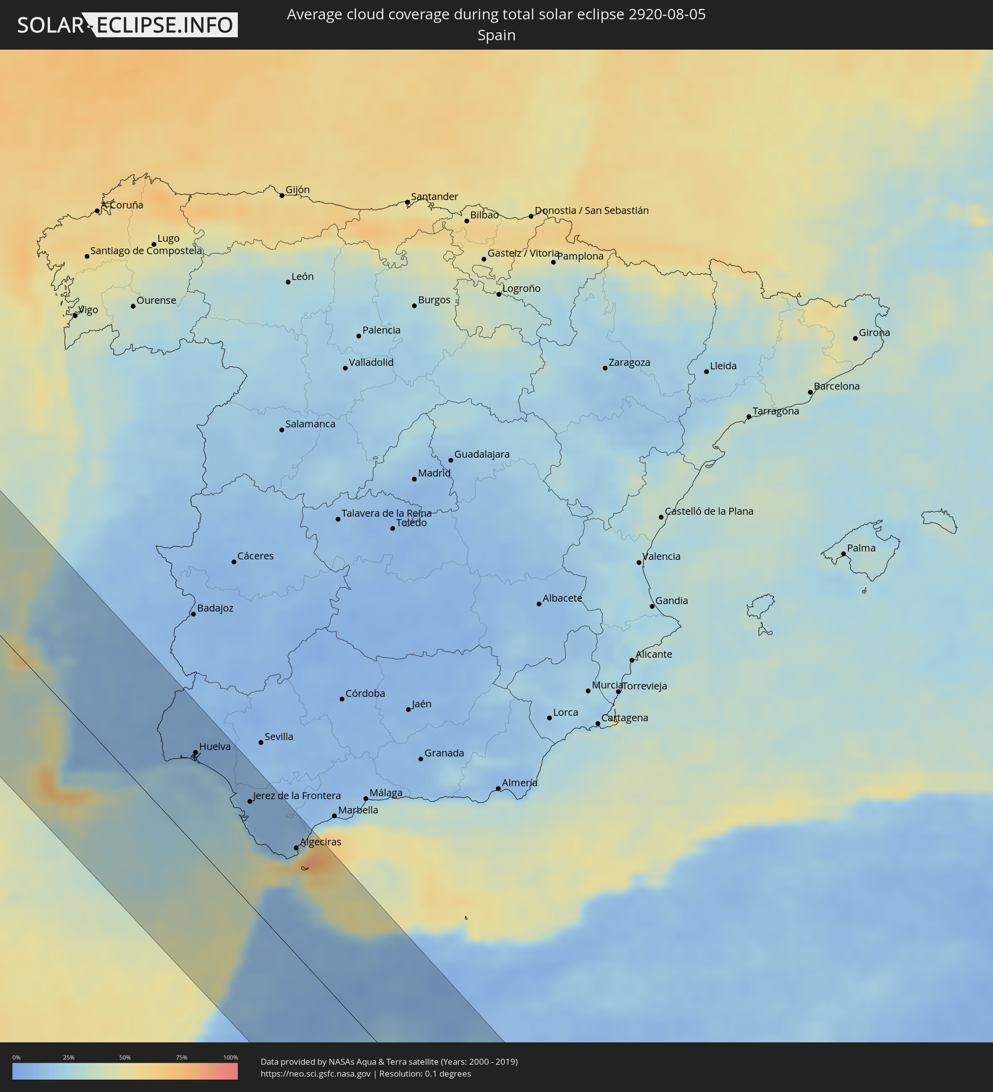 Spanien
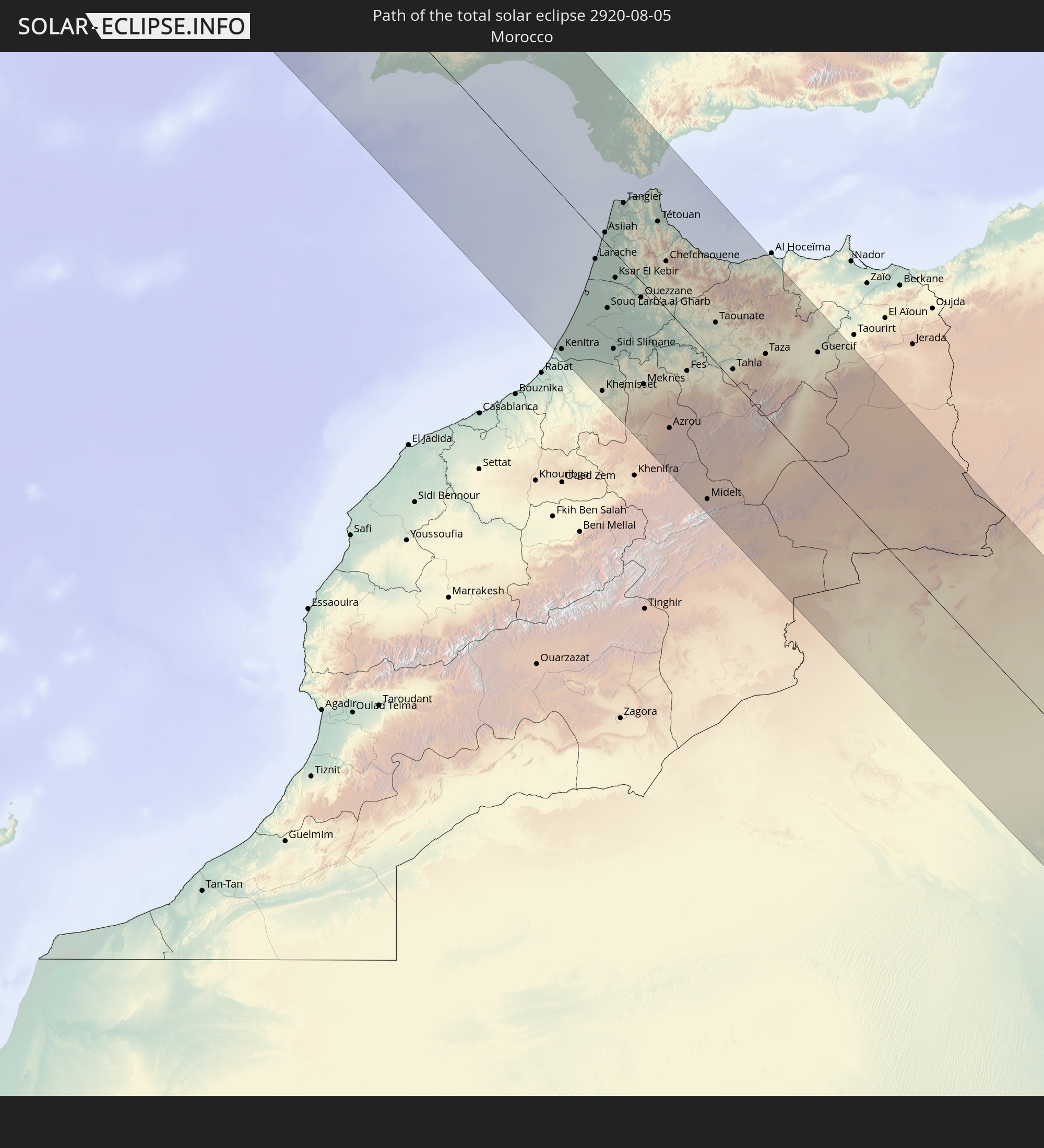
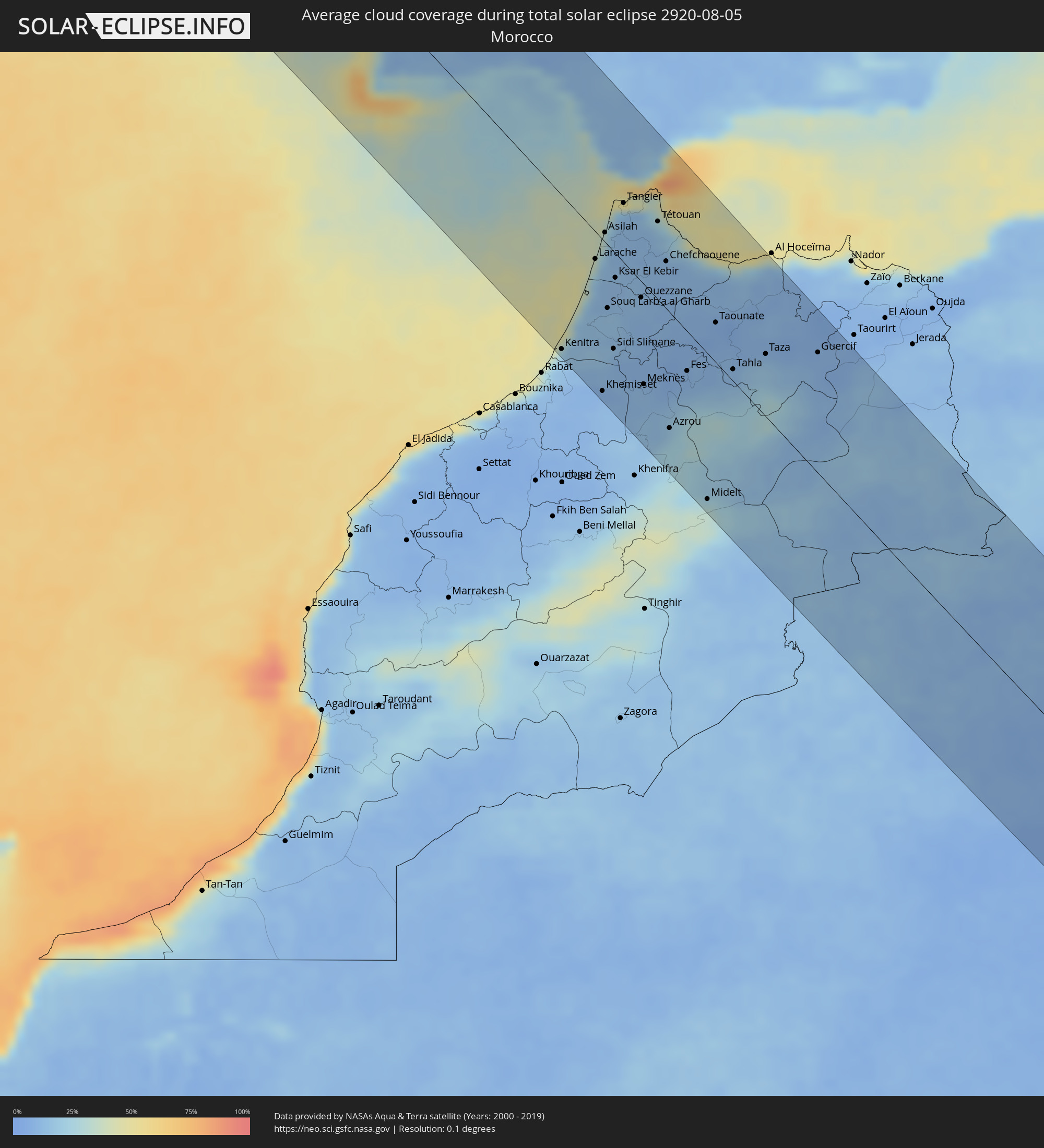 Marokko
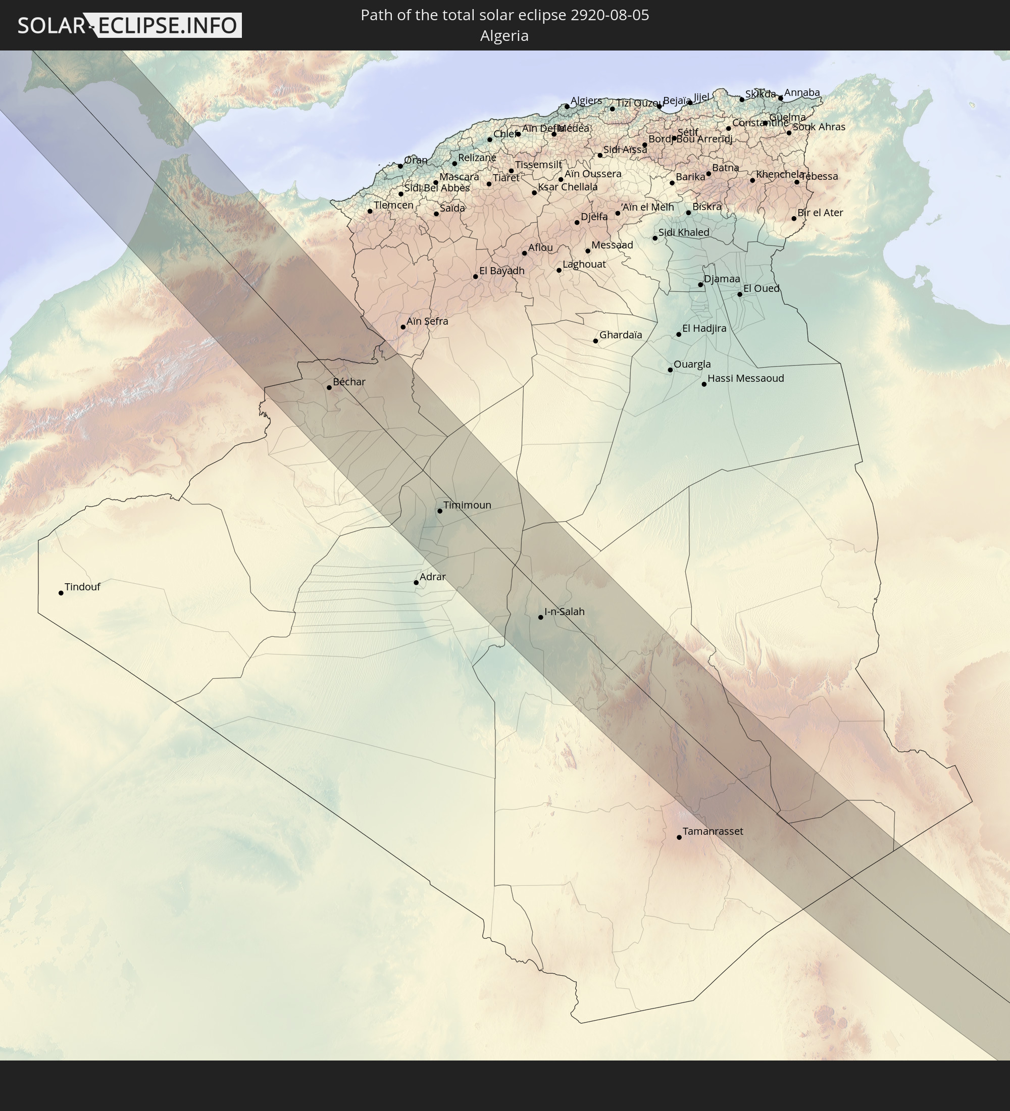
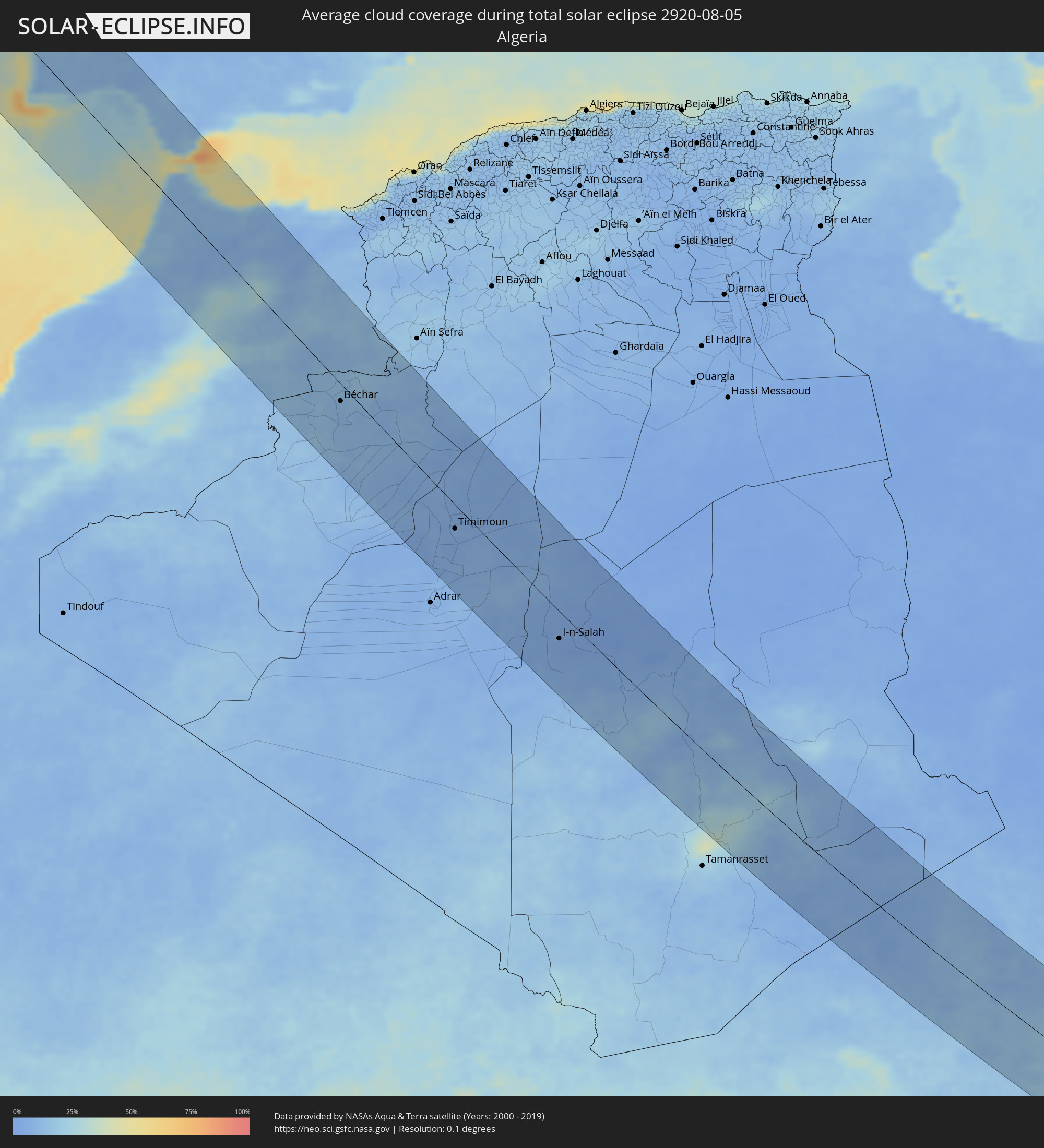 Algerien
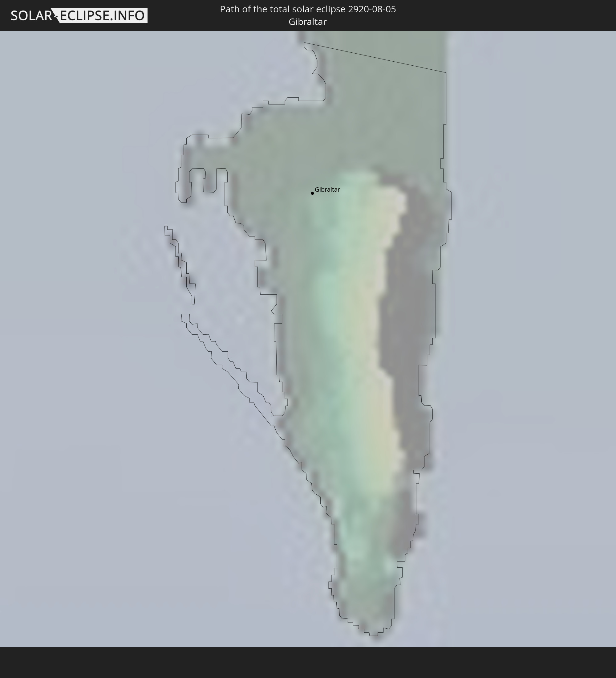
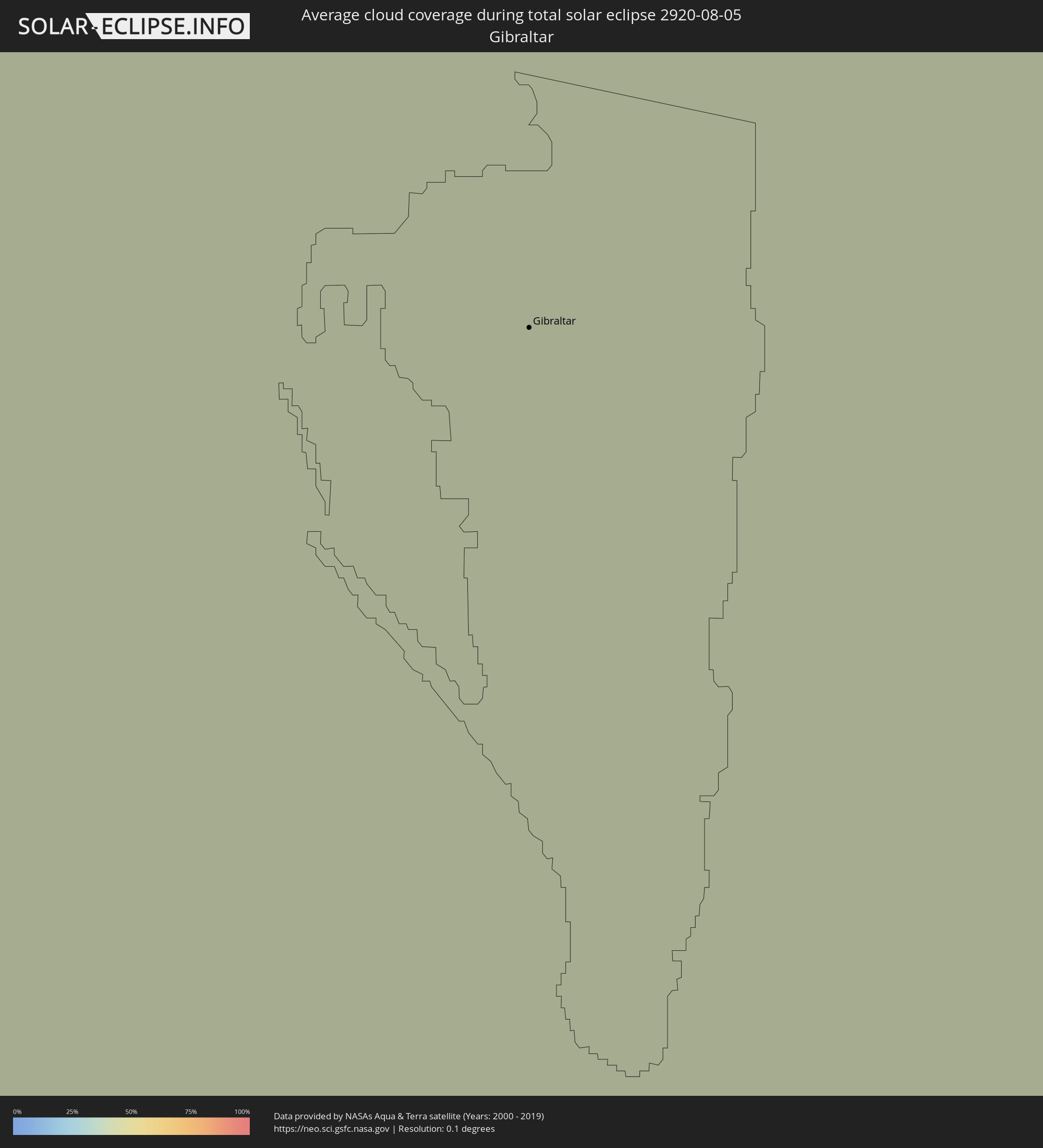 Gibraltar
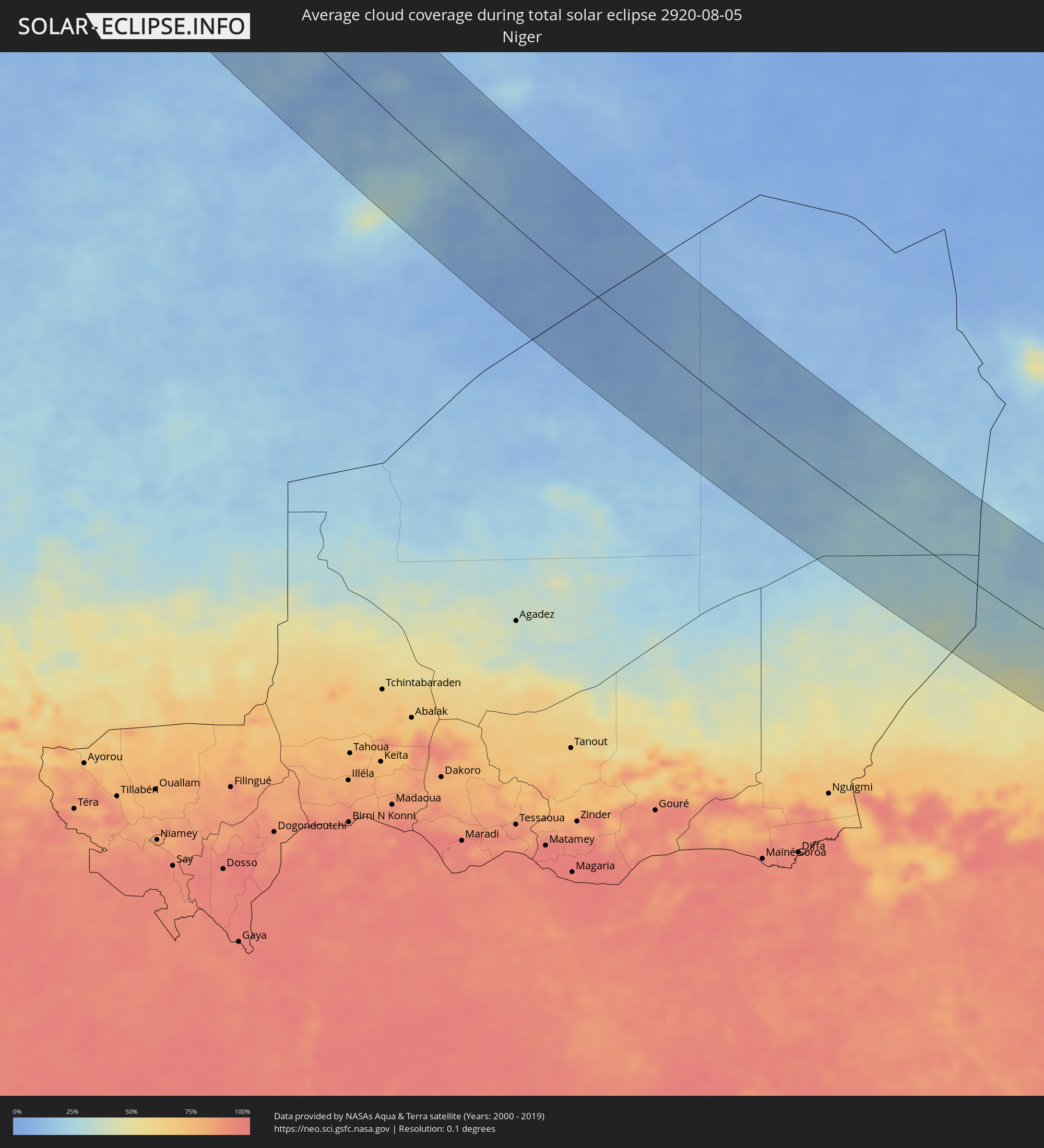 Niger
Niger
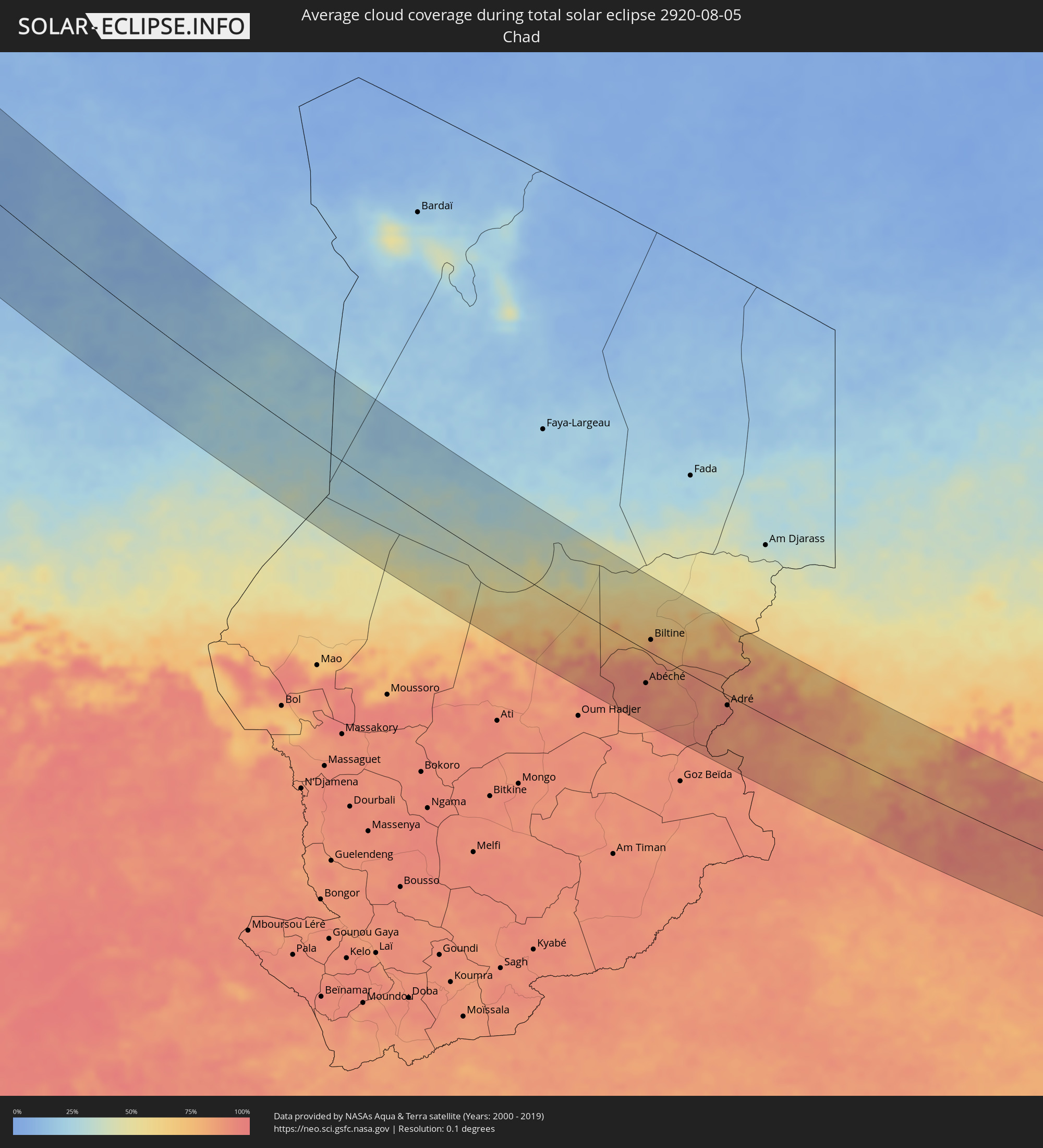 Tschad
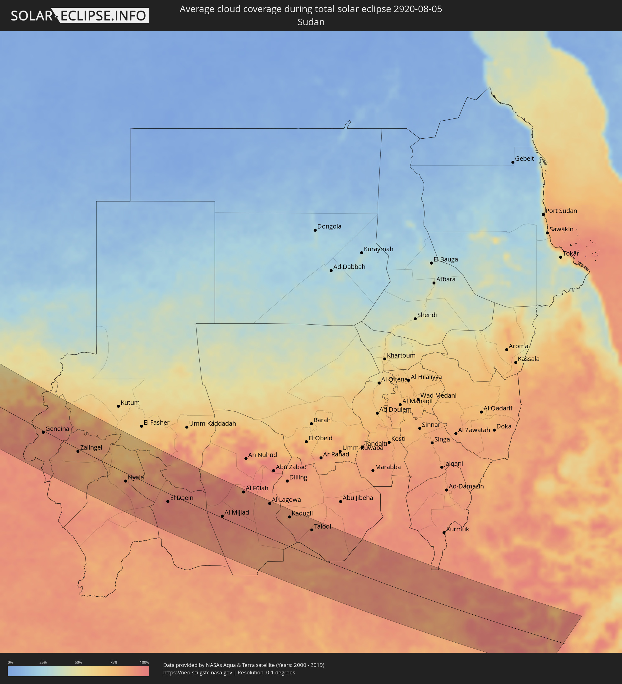 Sudan
Sudan
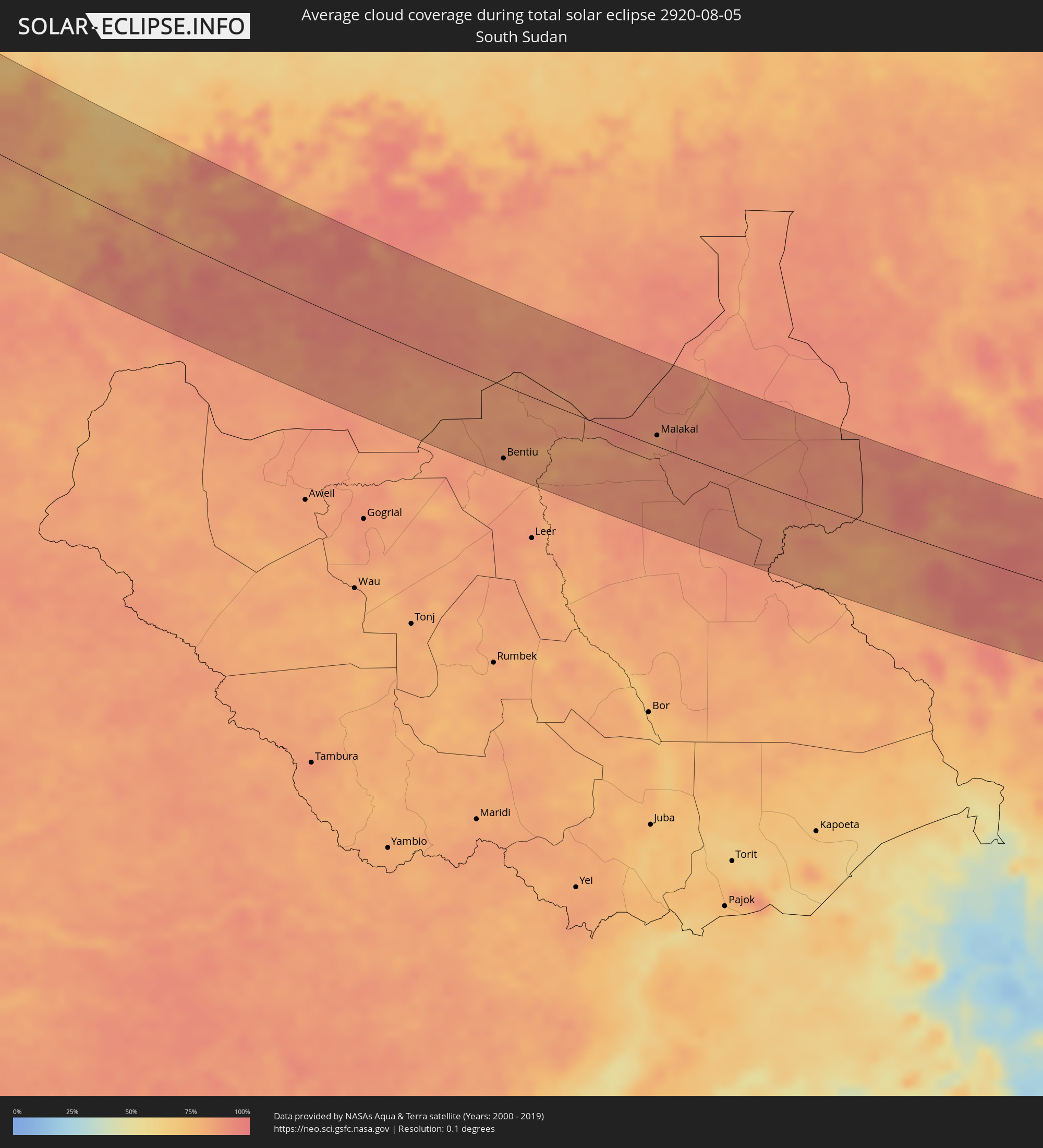 Südsudan
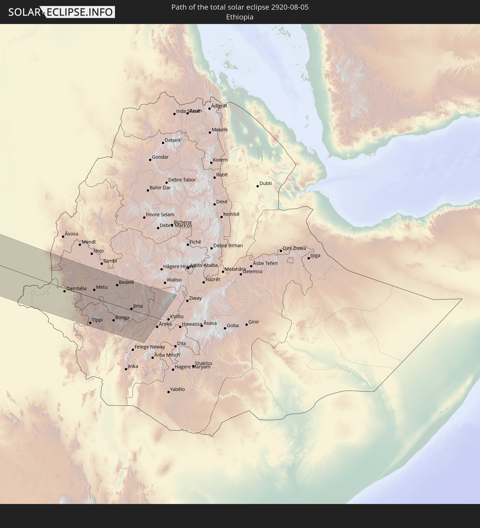
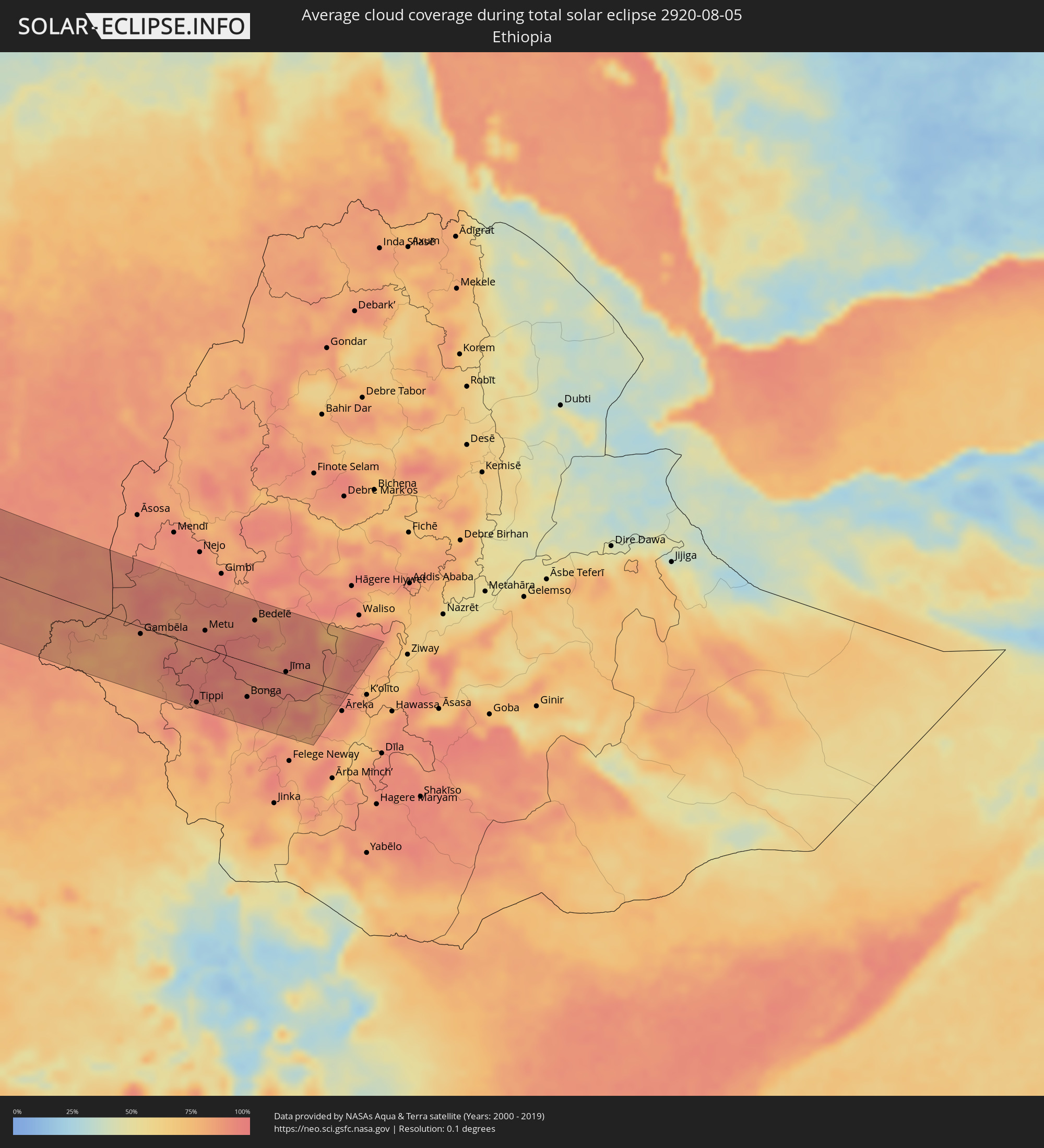 Äthiopien
Orte im Finsternispfad
Die nachfolgene Tabelle zeigt Städte und Orte mit mehr als 5.000 Einwohnern, die sich im Finsternispfad befinden. Städte mit mehr als 100.000 Einwohnern sind dick gekennzeichnet. Mit einem Klick auf den Ort öffnet sich eine Detailkarte die die Lage des jeweiligen Ortes zusammen mit dem Verlauf der zentralen Finsternis präsentiert.
| Ort | Typ | Dauer der Verfinsterung | Ortszeit bei maximaler Verfinsterung | Entfernung zur Zentrallinie | Ø Bewölkung |
|
Penticton, British Columbia
|
total | - | 04:45:16 UTC-08:00 | 6 km | 29% |
|
Kelowna, British Columbia
|
total | - | 04:45:36 UTC-08:00 | 32 km | 30% |
|
Okanagan, British Columbia
|
total | - | 04:46:00 UTC-08:00 | 75 km | 35% |
|
Revelstoke, British Columbia
|
total | - | 04:46:17 UTC-08:00 | 103 km | 48% |
|
Trail, British Columbia
|
total | - | 04:44:25 UTC-08:00 | 103 km | 32% |
|
Castlegar, British Columbia
|
total | - | 04:44:35 UTC-08:00 | 84 km | 35% |
|
Nelson, British Columbia
|
total | - | 04:44:40 UTC-08:00 | 75 km | 41% |
|
Canmore, Alberta
|
total | - | 05:45:44 UTC-07:00 | 26 km | 61% |
|
Cochrane, Alberta
|
total | - | 05:45:40 UTC-07:00 | 10 km | 47% |
|
Calgary, Alberta
|
total | - | 05:45:28 UTC-07:00 | 14 km | 47% |
|
Airdrie, Alberta
|
total | - | 05:45:42 UTC-07:00 | 9 km | 49% |
|
Okotoks, Alberta
|
total | - | 05:45:08 UTC-07:00 | 50 km | 45% |
|
High River, Alberta
|
total | - | 05:44:58 UTC-07:00 | 68 km | 45% |
|
Red Deer, Alberta
|
total | - | 05:46:37 UTC-07:00 | 101 km | 58% |
|
Strathmore, Alberta
|
total | - | 05:45:20 UTC-07:00 | 35 km | 44% |
|
Lloydminster, Saskatchewan
|
total | - | 05:47:11 UTC-07:00 | 99 km | 62% |
|
North Battleford, Saskatchewan
|
total | - | 06:46:31 UTC-06:00 | 3 km | 58% |
|
Saskatoon, Saskatchewan
|
total | - | 06:45:45 UTC-06:00 | 105 km | 56% |
|
Prince Albert, Saskatchewan
|
total | - | 06:46:51 UTC-06:00 | 17 km | 58% |
|
Thompson, Manitoba
|
total | - | 06:50:11 UTC-06:00 | 76 km | 71% |
|
Peniche, Leiria
|
total | - | 14:32:07 UTC+00:00 | 84 km | 44% |
|
Mafra, Lisbon
|
total | - | 14:32:57 UTC+00:00 | 56 km | 20% |
|
Cacém, Lisbon
|
total | - | 14:33:18 UTC+00:00 | 44 km | 16% |
|
Torres Vedras, Lisbon
|
total | - | 14:32:45 UTC+00:00 | 71 km | 26% |
|
Caldas da Rainha, Leiria
|
total | - | 14:32:20 UTC+00:00 | 103 km | 28% |
|
Lisbon, Lisbon
|
total | - | 14:33:36 UTC+00:00 | 51 km | 17% |
|
Sesimbra, Setúbal
|
total | - | 14:34:08 UTC+00:00 | 32 km | 36% |
|
Póvoa de Santa Iria, Lisbon
|
total | - | 14:33:25 UTC+00:00 | 66 km | 19% |
|
Setúbal, Setúbal
|
total | - | 14:34:15 UTC+00:00 | 52 km | 25% |
|
Samora Correia, Santarém
|
total | - | 14:33:31 UTC+00:00 | 84 km | 19% |
|
Sines, Setúbal
|
total | - | 14:35:19 UTC+00:00 | 10 km | 27% |
|
Santarém, Santarém
|
total | - | 14:33:12 UTC+00:00 | 119 km | 14% |
|
Portimão, Faro
|
total | - | 14:37:15 UTC+00:00 | 31 km | 28% |
|
Albufeira, Faro
|
total | - | 14:37:41 UTC+00:00 | 16 km | 26% |
|
Montemor-o-Novo, Évora
|
total | - | 14:34:51 UTC+00:00 | 104 km | 11% |
|
Loulé, Faro
|
total | - | 14:37:53 UTC+00:00 | 3 km | 19% |
|
Faro, Faro
|
total | - | 14:38:12 UTC+00:00 | 0 km | 33% |
|
Évora, Évora
|
total | - | 14:35:23 UTC+00:00 | 118 km | 10% |
|
Beja, Beja
|
total | - | 14:36:27 UTC+00:00 | 79 km | 11% |
|
Tavira, Faro
|
total | - | 14:38:21 UTC+00:00 | 26 km | 24% |
|
Ayamonte, Andalusia
|
total | - | 15:38:29 UTC+01:00 | 49 km | 22% |
|
Lepe, Andalusia
|
total | - | 15:38:39 UTC+01:00 | 65 km | 16% |
|
Cartaya, Andalusia
|
total | - | 15:38:40 UTC+01:00 | 70 km | 16% |
|
Aljaraque, Andalusia
|
total | - | 15:38:50 UTC+01:00 | 78 km | 11% |
|
Punta Umbría, Andalusia
|
total | - | 15:39:04 UTC+01:00 | 75 km | 22% |
|
Huelva, Andalusia
|
total | - | 15:38:57 UTC+01:00 | 83 km | 9% |
|
Kenitra, Gharb-Chrarda-Beni Hssen
|
total | - | 15:45:02 UTC+01:00 | 120 km | 19% |
|
Bollullos par del Condado, Andalusia
|
total | - | 15:39:17 UTC+01:00 | 115 km | 11% |
|
Almonte, Andalusia
|
total | - | 15:39:27 UTC+01:00 | 111 km | 11% |
|
Chipiona, Andalusia
|
total | - | 15:40:32 UTC+01:00 | 76 km | 25% |
|
Sanlúcar de Barrameda, Andalusia
|
total | - | 15:40:33 UTC+01:00 | 85 km | 20% |
|
Cadiz, Andalusia
|
total | - | 15:41:05 UTC+01:00 | 70 km | 32% |
|
Larache, Tanger-Tétouan
|
total | - | 15:43:46 UTC+01:00 | 21 km | 34% |
|
Chiclana de la Frontera, Andalusia
|
total | - | 15:41:28 UTC+01:00 | 72 km | 16% |
|
Jerez de la Frontera, Andalusia
|
total | - | 15:40:58 UTC+01:00 | 92 km | 13% |
|
Conil de la Frontera, Andalusia
|
total | - | 15:41:48 UTC+01:00 | 65 km | 28% |
|
Lebrija, Andalusia
|
total | - | 15:40:36 UTC+01:00 | 114 km | 11% |
|
Khemisset, Rabat-Salé-Zemmour-Zaër
|
total | - | 15:46:28 UTC+01:00 | 119 km | 10% |
|
Souq Larb’a al Gharb, Gharb-Chrarda-Beni Hssen
|
total | - | 15:44:54 UTC+01:00 | 49 km | 16% |
|
Sidi Slimane, Gharb-Chrarda-Beni Hssen
|
total | - | 15:45:48 UTC+01:00 | 76 km | 11% |
|
Barbate de Franco, Andalusia
|
total | - | 15:42:09 UTC+01:00 | 70 km | 31% |
|
Ksar El Kebir, Tanger-Tétouan
|
total | - | 15:44:26 UTC+01:00 | 19 km | 12% |
|
Arcos de la Frontera, Andalusia
|
total | - | 15:41:14 UTC+01:00 | 119 km | 12% |
|
Tangier, Tanger-Tétouan
|
total | - | 15:43:06 UTC+01:00 | 46 km | 17% |
|
Sidi Qacem, Gharb-Chrarda-Beni Hssen
|
total | - | 15:46:08 UTC+01:00 | 65 km | 9% |
|
Tarifa, Andalusia
|
total | - | 15:42:51 UTC+01:00 | 77 km | 63% |
|
Ouezzane, Gharb-Chrarda-Beni Hssen
|
total | - | 15:45:11 UTC+01:00 | 12 km | 11% |
|
Meknès, Meknès-Tafilalet
|
total | - | 15:46:57 UTC+01:00 | 79 km | 11% |
|
Algeciras, Andalusia
|
total | - | 15:42:49 UTC+01:00 | 97 km | 51% |
|
Tétouan, Tanger-Tétouan
|
total | - | 15:43:57 UTC+01:00 | 61 km | 19% |
|
Gibraltar
|
total | - | 15:42:54 UTC+01:00 | 104 km | 73% |
|
Ceuta, Ceuta
|
total | - | 15:43:25 UTC+01:00 | 87 km | 55% |
|
Martil, Tanger-Tétouan
|
total | - | 15:43:59 UTC+01:00 | 70 km | 25% |
|
Chefchaouene, Tanger-Tétouan
|
total | - | 15:44:51 UTC+01:00 | 37 km | 11% |
|
Azrou, Meknès-Tafilalet
|
total | - | 15:48:12 UTC+01:00 | 91 km | 23% |
|
Fes, Fès-Boulemane
|
total | - | 15:47:18 UTC+01:00 | 31 km | 10% |
|
Sefrou, Fès-Boulemane
|
total | - | 15:47:53 UTC+01:00 | 35 km | 19% |
|
Midelt, Meknès-Tafilalet
|
total | - | 15:50:10 UTC+01:00 | 116 km | 28% |
|
Taounate, Taza-Al Hoceima-Taounate
|
total | - | 15:46:45 UTC+01:00 | 31 km | 8% |
|
Taza, Taza-Al Hoceima-Taounate
|
total | - | 15:48:04 UTC+01:00 | 49 km | 14% |
|
Guercif, Taza-Al Hoceima-Taounate
|
total | - | 15:48:46 UTC+01:00 | 95 km | 9% |
|
Béchar, Béchar
|
total | - | 15:54:57 UTC+01:00 | 24 km | 12% |
|
Timimoun, Adrar
|
total | - | 16:01:51 UTC+01:00 | 34 km | 8% |
|
I-n-Salah, Tamanrasset
|
total | - | 16:07:44 UTC+01:00 | 41 km | 4% |
|
Abéché, Ouadaï
|
total | - | 16:38:47 UTC+01:00 | 52 km | 92% |
|
Biltine, Wadi Fira
|
total | - | 16:37:52 UTC+01:00 | 20 km | 85% |
|
Adré, Ouadaï
|
total | - | 16:39:29 UTC+01:00 | 16 km | 92% |
|
Geneina, Western Darfur
|
total | - | 17:39:32 UTC+02:00 | 5 km | 86% |
|
Zalingei, Central Darfur
|
total | - | 17:40:21 UTC+02:00 | 7 km | 87% |
|
Nyala, Southern Darfur
|
total | - | 17:41:32 UTC+02:00 | 24 km | 91% |
|
El Daein, Eastern Darfur
|
total | - | 17:42:17 UTC+02:00 | 25 km | 95% |
|
Al Mijlad, West Kordofan State
|
total | - | 17:42:47 UTC+02:00 | 4 km | 94% |
|
El Fula, West Kordofan State
|
total | - | 17:41:59 UTC+02:00 | 100 km | 91% |
|
Al Fūlah, Southern Kordofan
|
total | - | 17:41:57 UTC+02:00 | 103 km | 90% |
|
Al Lagowa, West Kordofan State
|
total | - | 17:42:19 UTC+02:00 | 103 km | 89% |
|
Kadugli, Southern Kordofan
|
total | - | 17:42:43 UTC+02:00 | 88 km | 85% |
 Bentiu, Unity
|
total | - | 17:44:40 UTC+02:00 | 90 km | 86% |
|
Talodi, Southern Kordofan
|
total | - | 17:43:06 UTC+02:00 | 76 km | 92% |
|
Malakal, Upper Nile
|
total | - | 17:44:10 UTC+02:00 | 14 km | 87% |
|
Gambēla, Gambela
|
total | - | 18:45:00 UTC+03:00 | 12 km | 84% |
|
Dembī Dolo, Oromiya
|
total | - | 18:44:41 UTC+03:00 | 26 km | 91% |
|
Tippi, Southern Nations, Nationalities, and People's Region
|
total | - | 18:45:51 UTC+03:00 | 92 km | 89% |
|
Gorē, Oromiya
|
total | - | 18:44:54 UTC+03:00 | 11 km | 92% |
|
Metu, Oromiya
|
total | - | 18:44:44 UTC+03:00 | 29 km | 92% |
|
Bonga, Southern Nations, Nationalities, and People's Region
|
total | - | 18:45:35 UTC+03:00 | 57 km | 94% |
|
Bedelē, Oromiya
|
total | - | 18:44:24 UTC+03:00 | 72 km | 90% |
|
Āgaro, Oromiya
|
total | - | 18:44:56 UTC+03:00 | 17 km | 87% |
|
Jīma, Oromiya
|
total | - | 18:45:04 UTC+03:00 | 4 km | 89% |