Totale Sonnenfinsternis vom 04.05.2972
| Wochentag: | Montag |
| Maximale Dauer der Verfinsterung: | 04m40s |
| Maximale Breite des Finsternispfades: | 251 km |
| Saroszyklus: | 173 |
| Bedeckungsgrad: | 100% |
| Magnitude: | 1.0657 |
| Gamma: | 0.5235 |
Wo kann man die Sonnenfinsternis vom 04.05.2972 sehen?
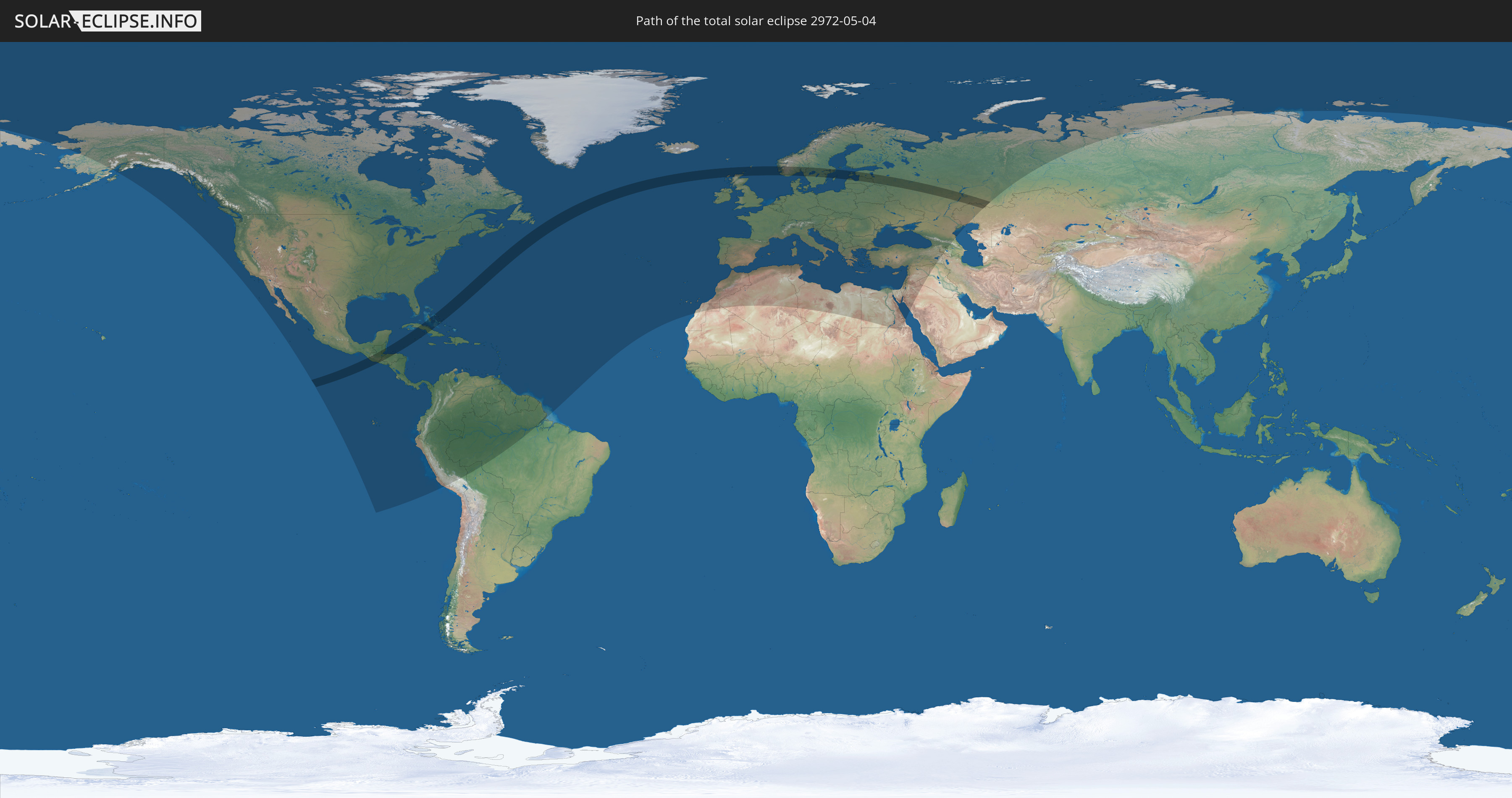
Die Sonnenfinsternis am 04.05.2972 kann man in 120 Ländern als partielle Sonnenfinsternis beobachten.
Der Finsternispfad verläuft durch 16 Länder. Nur in diesen Ländern ist sie als totale Sonnenfinsternis zu sehen.
In den folgenden Ländern ist die Sonnenfinsternis total zu sehen
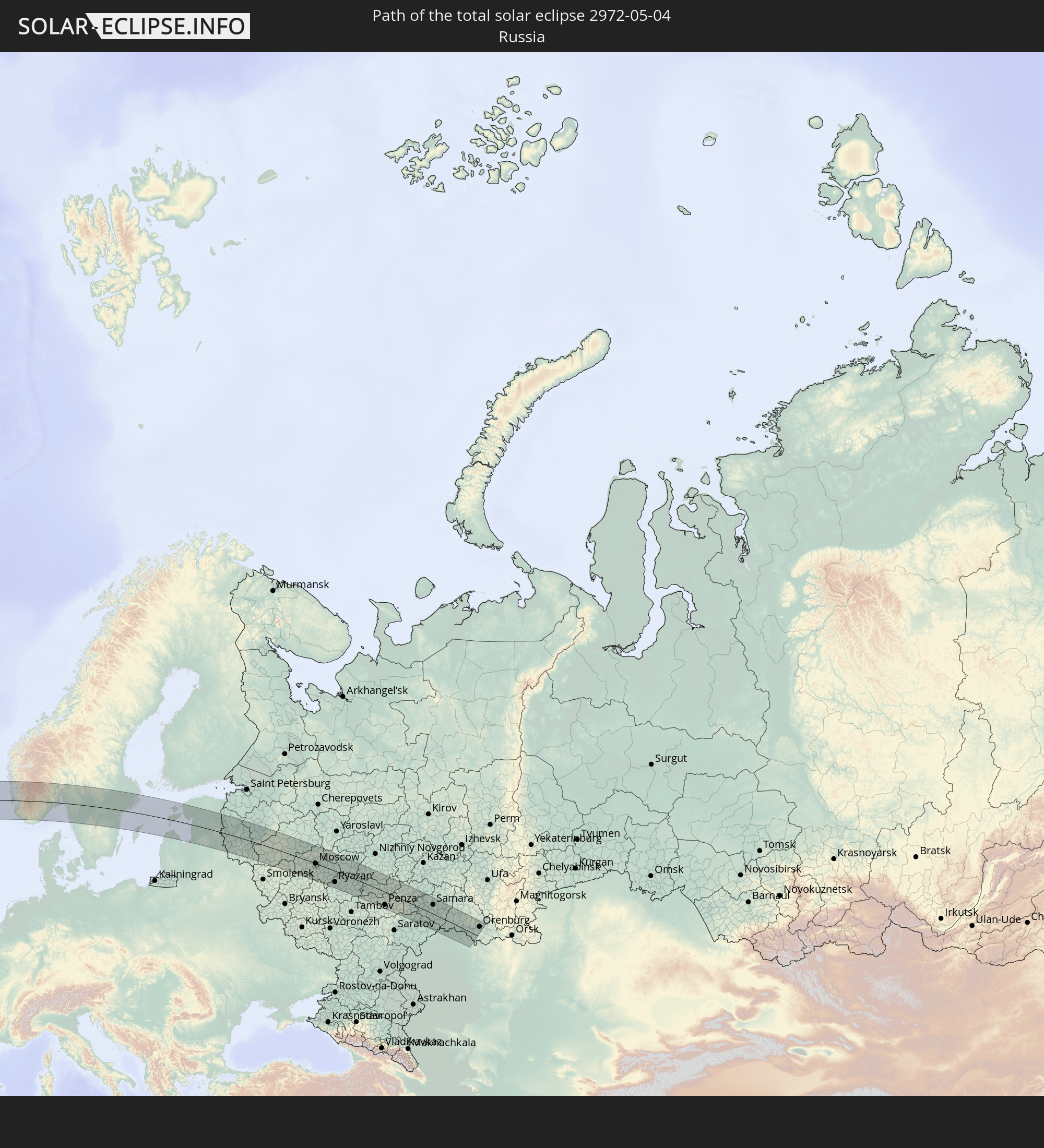 Russland
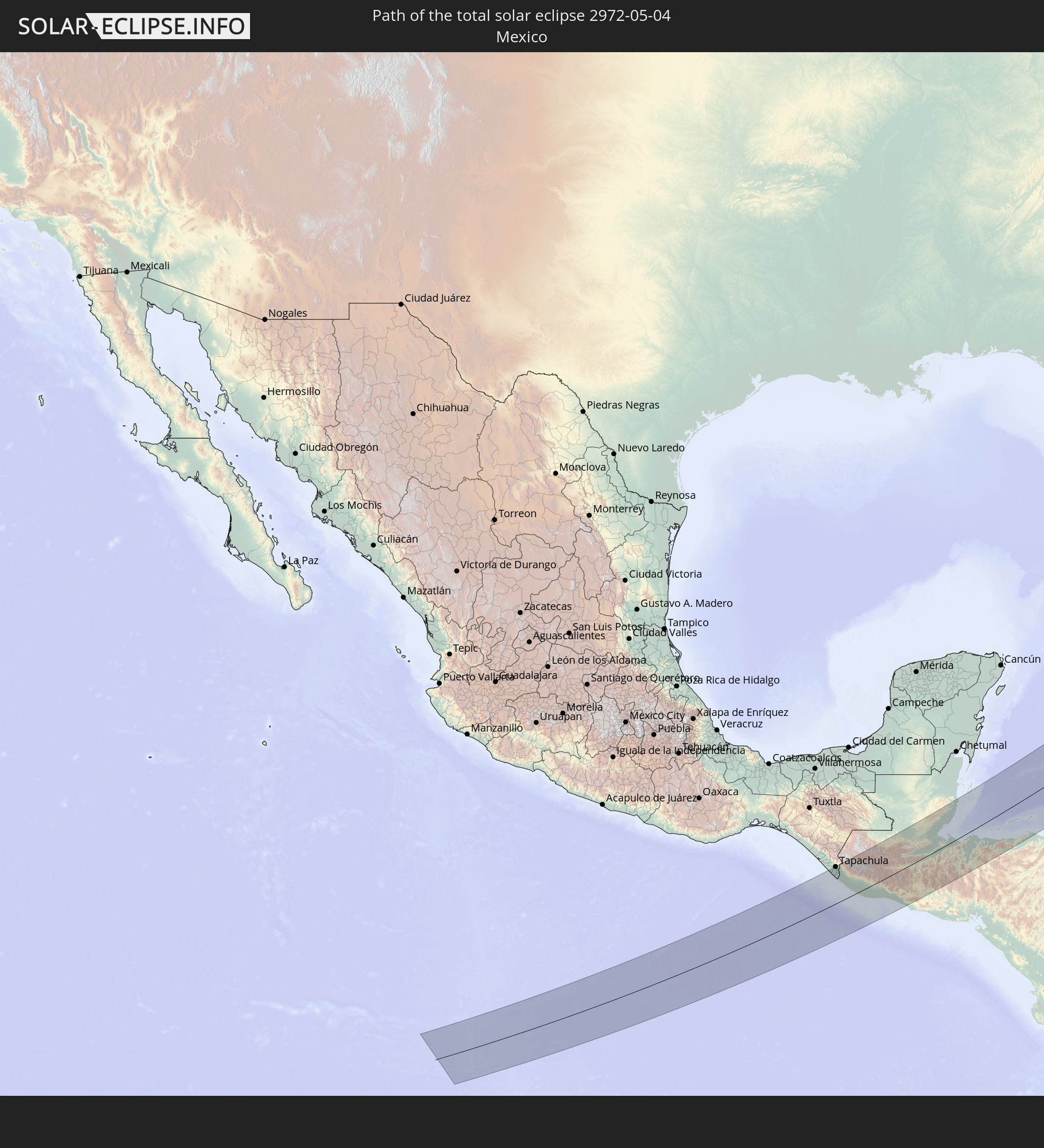 Mexiko
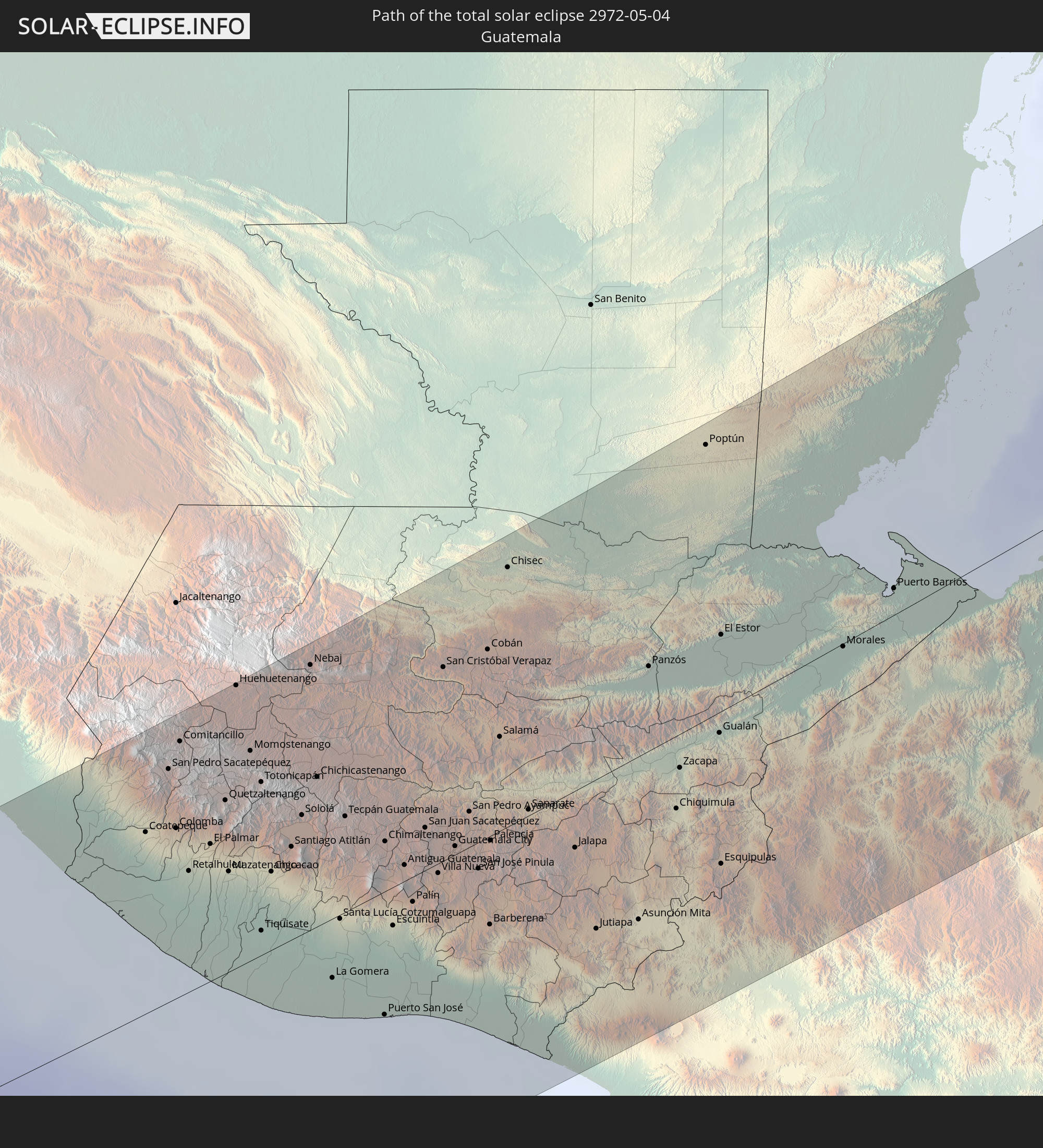 Guatemala
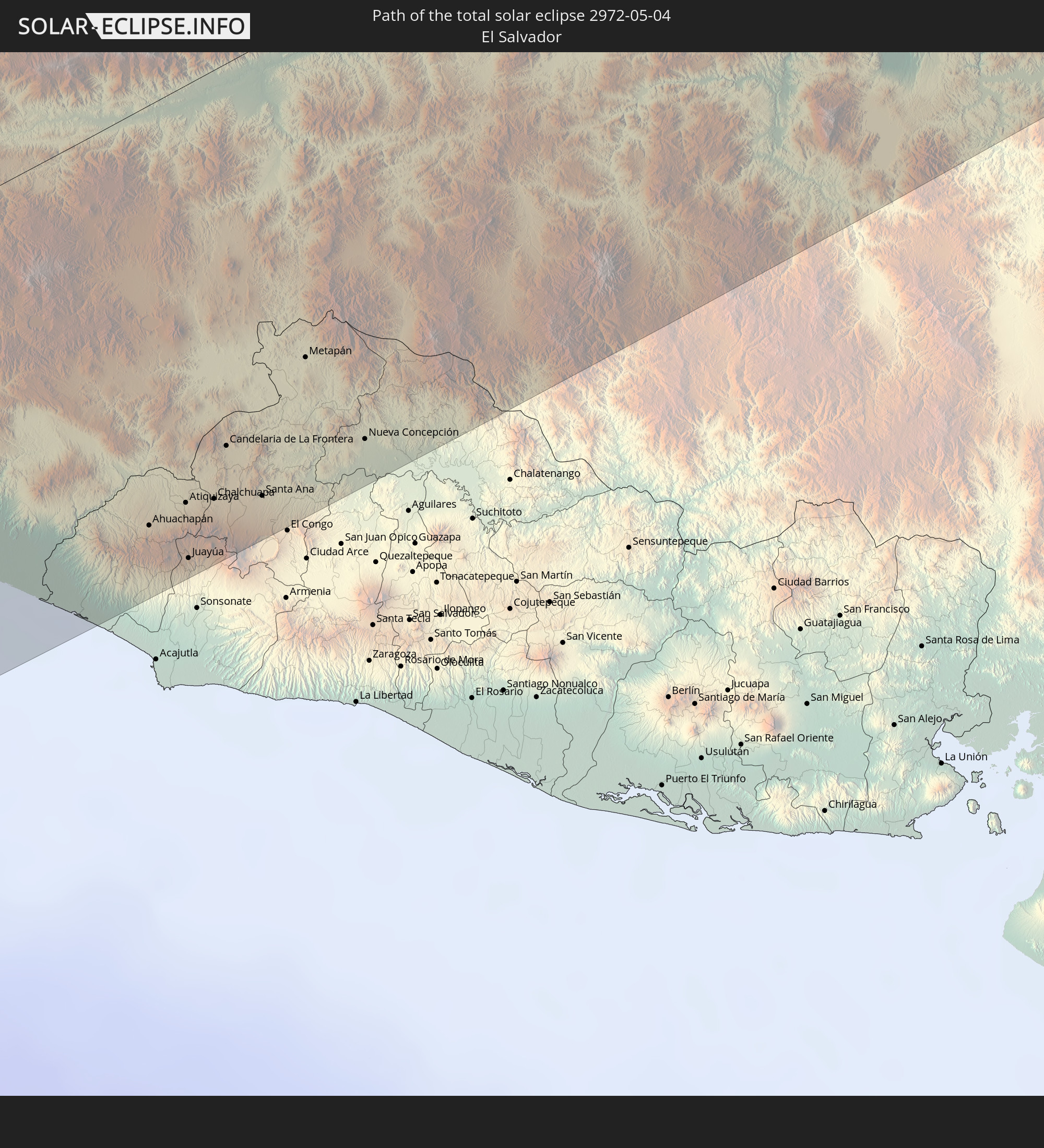 El Salvador
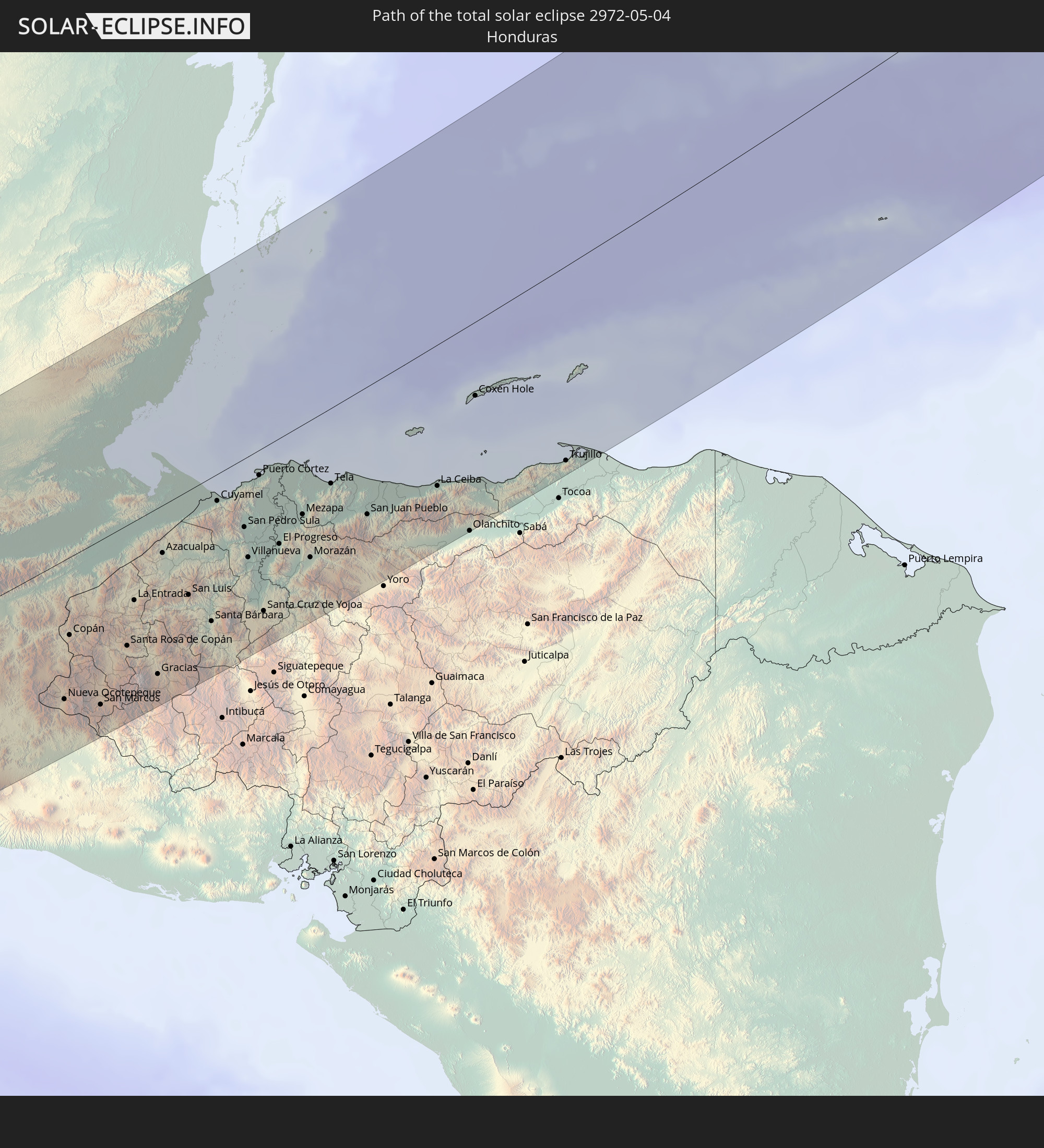 Honduras
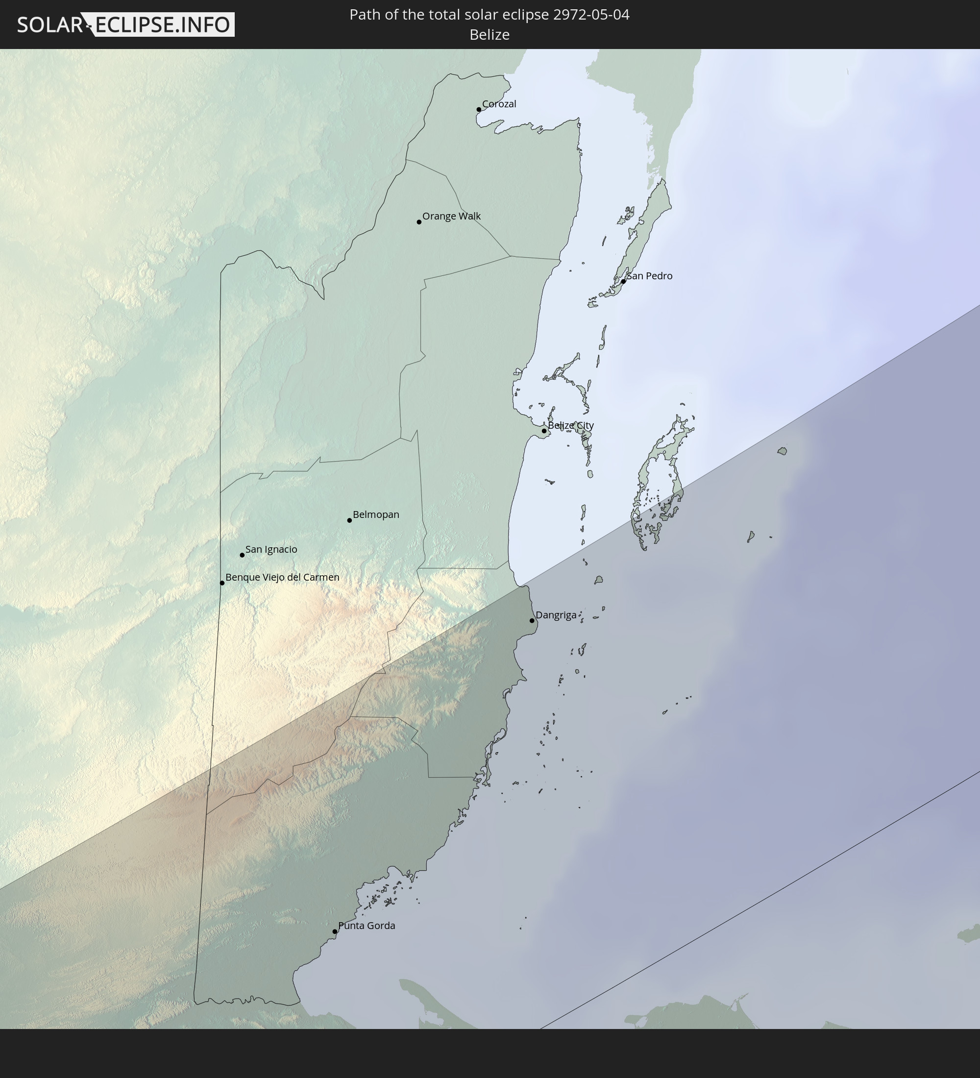 Belize
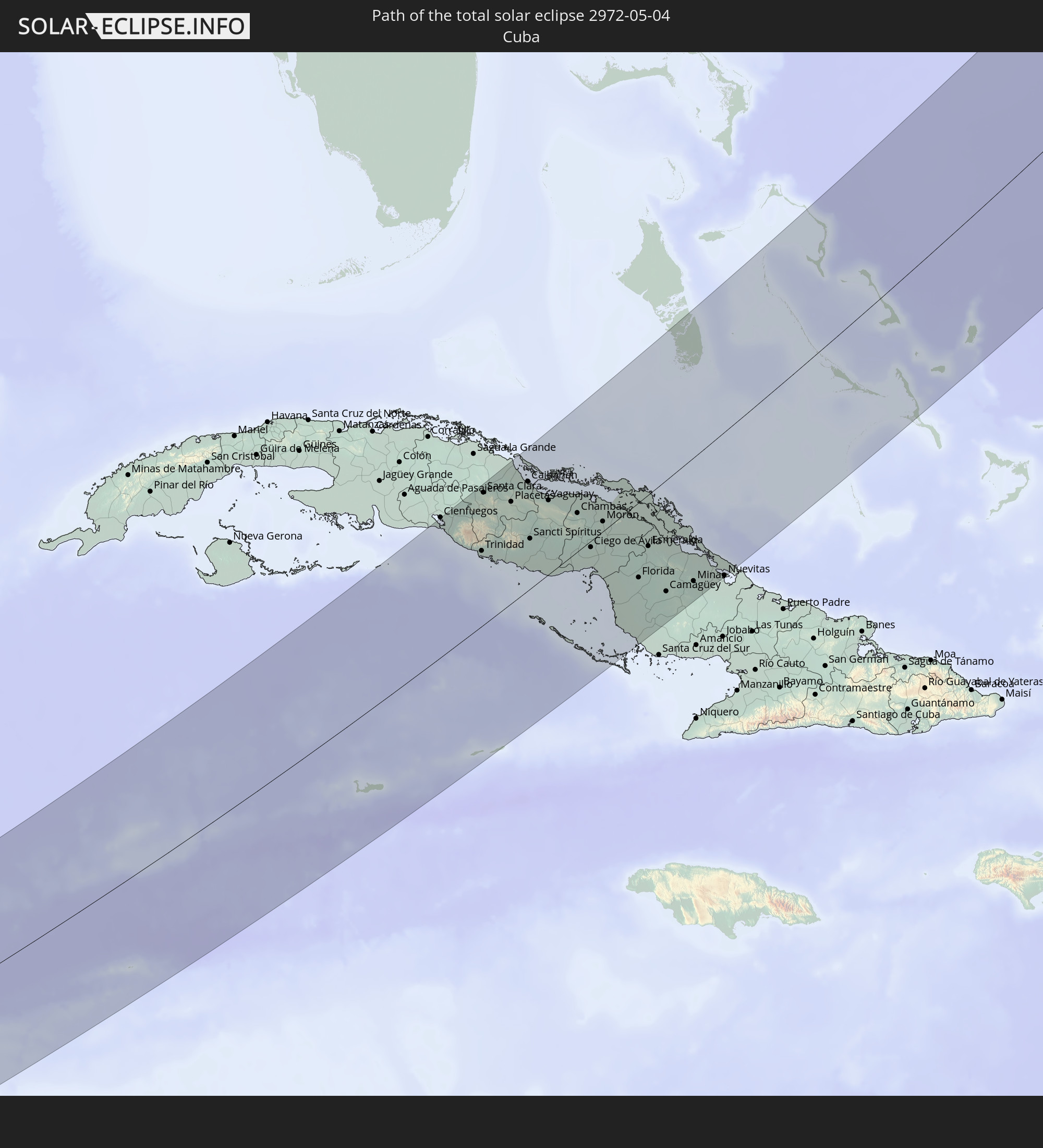 Kuba
Kuba
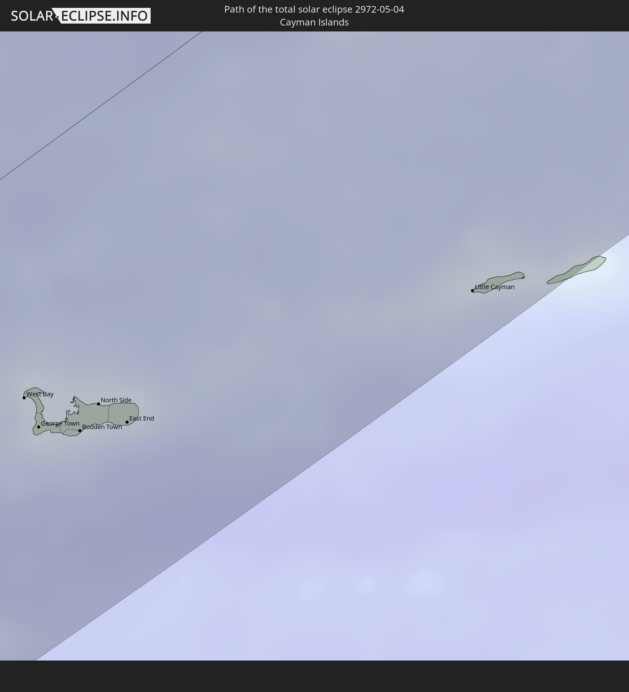 Kaimaninseln
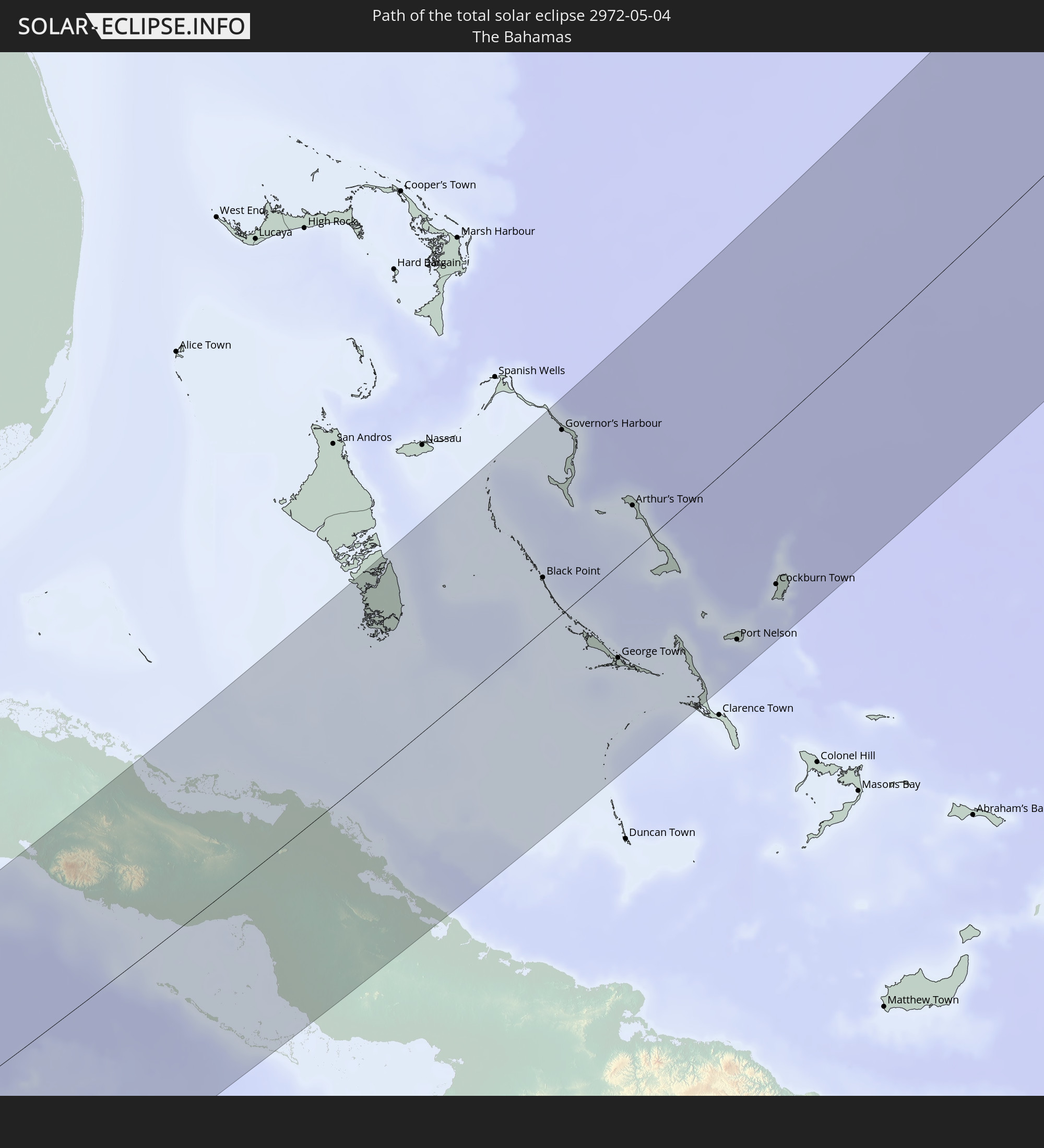 Bahamas
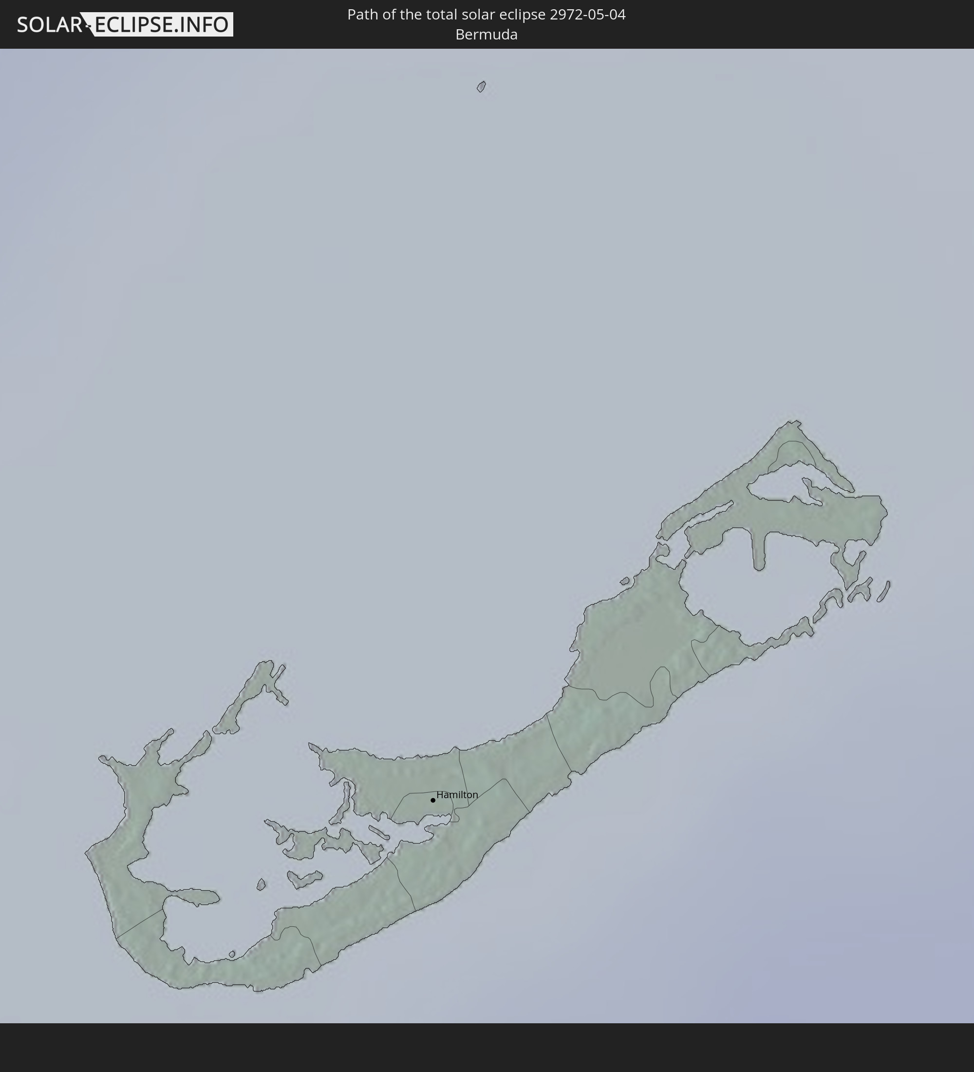 Bermuda
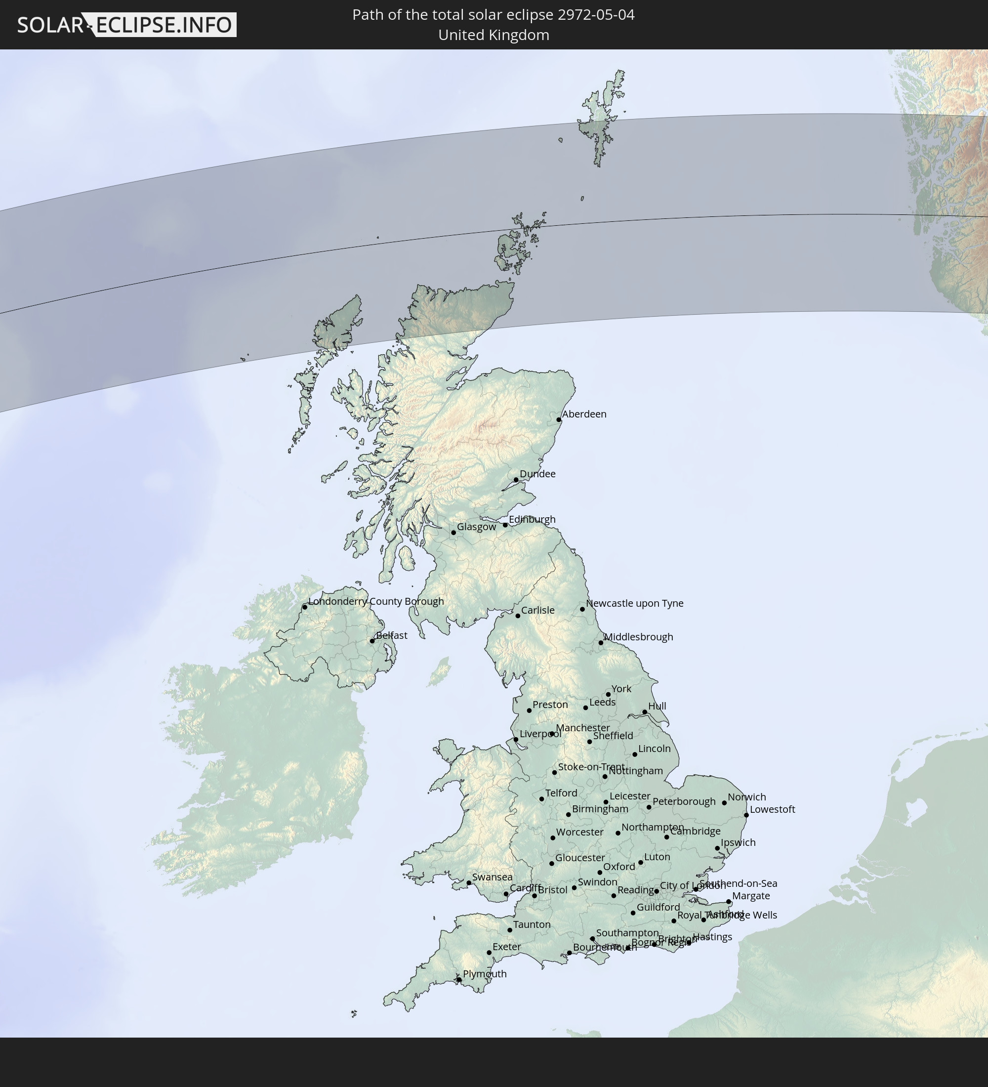 Vereinigtes Königreich
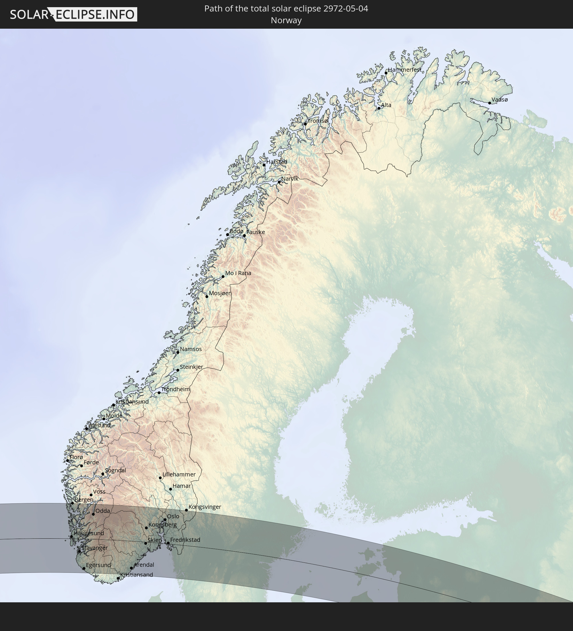 Norwegen
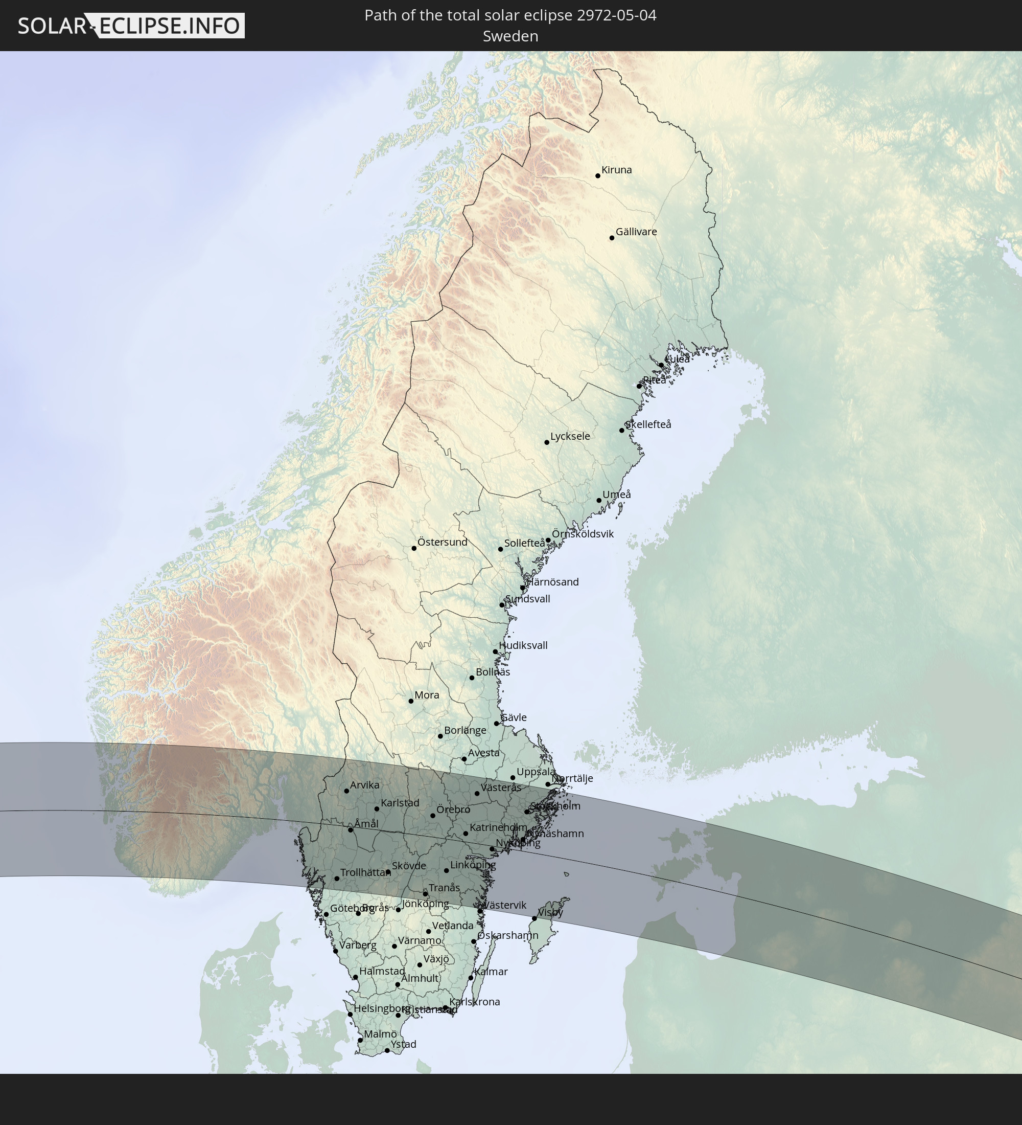 Schweden
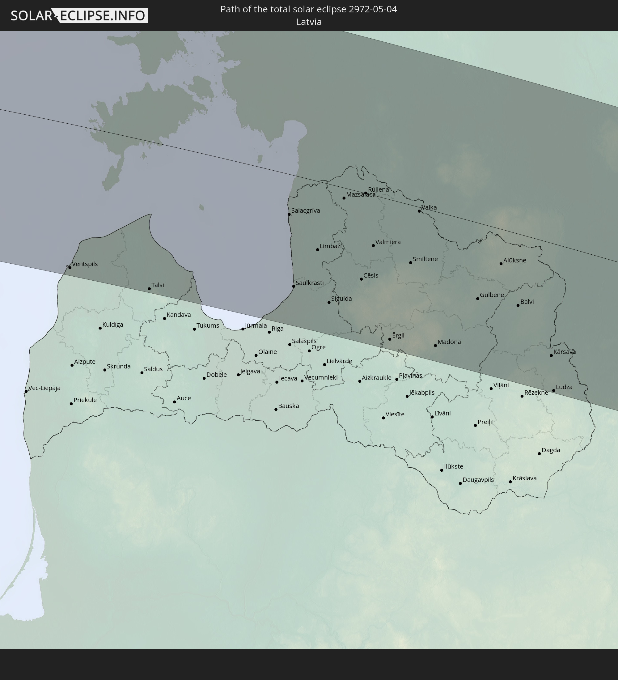 Lettland
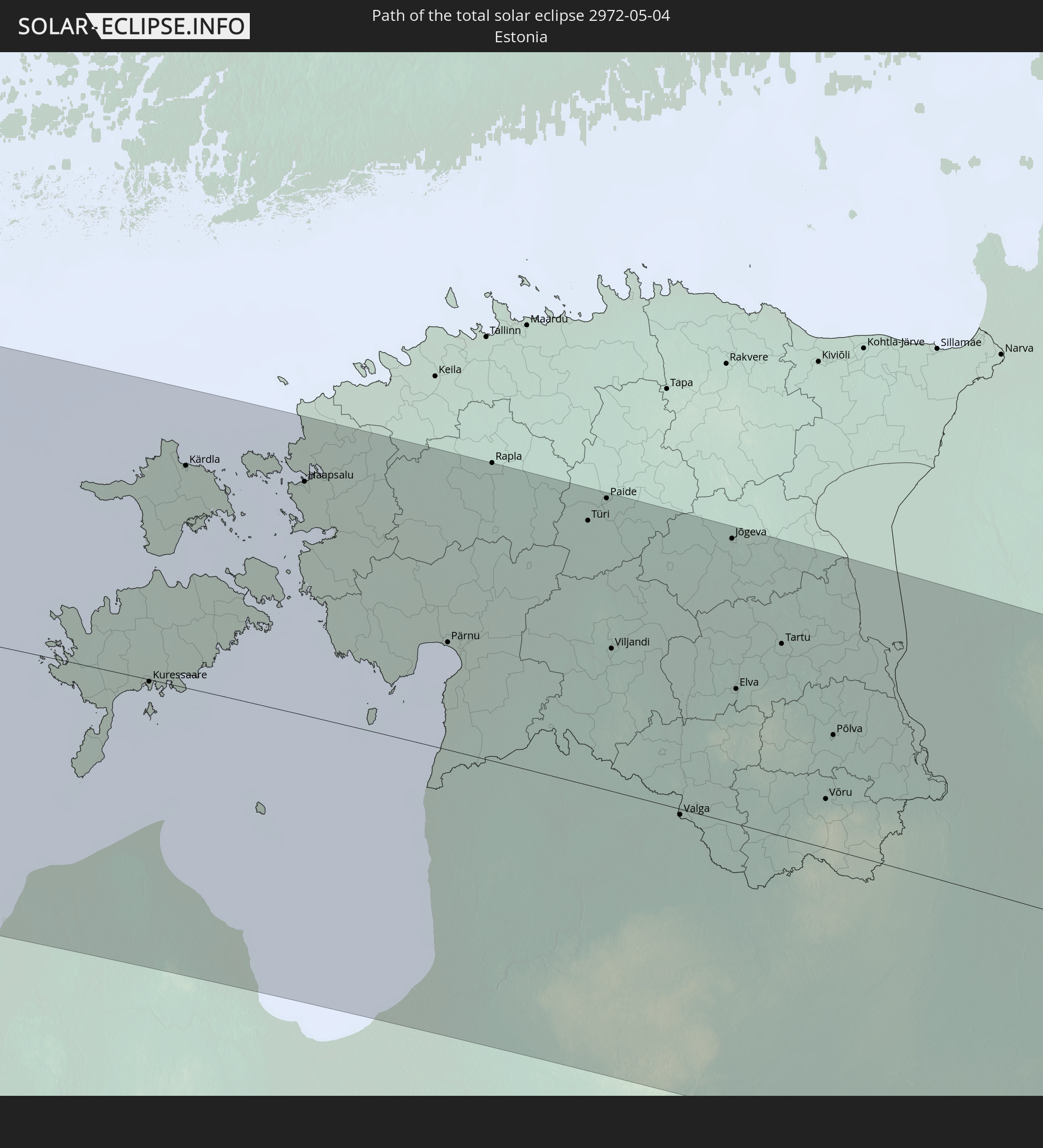 Estland
 Kasachstan
In den folgenden Ländern ist die Sonnenfinsternis partiell zu sehen
 Russland
 Vereinigte Staaten
 United States Minor Outlying Islands
 Kanada
 Mexiko
 Grönland
 Guatemala
 Ecuador
 El Salvador
 Honduras
 Belize
 Nicaragua
 Costa Rica
 Kuba
Kuba
 Panama
 Kolumbien
 Kaimaninseln
 Peru
Peru
 Bahamas
 Jamaika
 Haiti
Haiti
 Brasilien
 Venezuela
 Turks- und Caicosinseln
 Dominikanische Republik
 Aruba
Aruba
 Bolivien
 Puerto Rico
 Amerikanische Jungferninseln
 Bermuda
 Britische Jungferninseln
 Anguilla
 Saint-Martin
 Saint-Barthélemy
 St. Kitts und Nevis
 Antigua und Barbuda
 Montserrat
 Trinidad und Tobago
 Guadeloupe
 Grenada
 Dominica
 St. Vincent und die Grenadinen
 Guyana
 Martinique
 St. Lucia
 Barbados
 Suriname
 Saint-Pierre und Miquelon
 Französisch-Guayana
 Portugal
 Island
 Spanien
 Mauretanien
 Marokko
 Irland
 Spitzbergen
 Algerien
 Vereinigtes Königreich
 Färöer
 Gibraltar
 Frankreich
 Isle of Man
 Guernsey
 Jersey
 Andorra
 Belgien
 Niederlande
 Norwegen
 Luxemburg
 Deutschland
 Schweiz
 Italien
 Monaco
 Tunesien
 Dänemark
 Libyen
 Liechtenstein
 Österreich
 Schweden
 Tschechien
 San Marino
 Vatikanstadt
 Slowenien
 Kroatien
 Polen
Polen
 Malta
Malta
 Bosnien und Herzegowina
 Ungarn
 Slowakei
 Montenegro
 Serbien
 Albanien
 Åland Islands
 Griechenland
 Rumänien
 Mazedonien
 Finnland
 Litauen
 Lettland
 Estland
 Sudan
Sudan
 Ukraine
 Bulgarien
 Weißrussland
 Ägypten
 Türkei
 Moldawien
 Republik Zypern
 Staat Palästina
 Israel
 Saudi-Arabien
 Jordanien
 Libanon
 Syrien
 Irak
Irak
 Georgien
 Armenien
 Iran
Iran
 Aserbaidschan
 Kasachstan
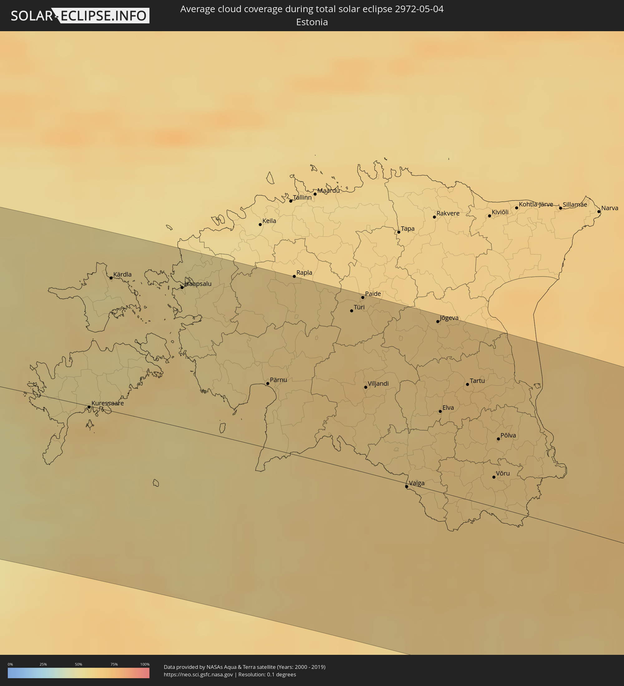
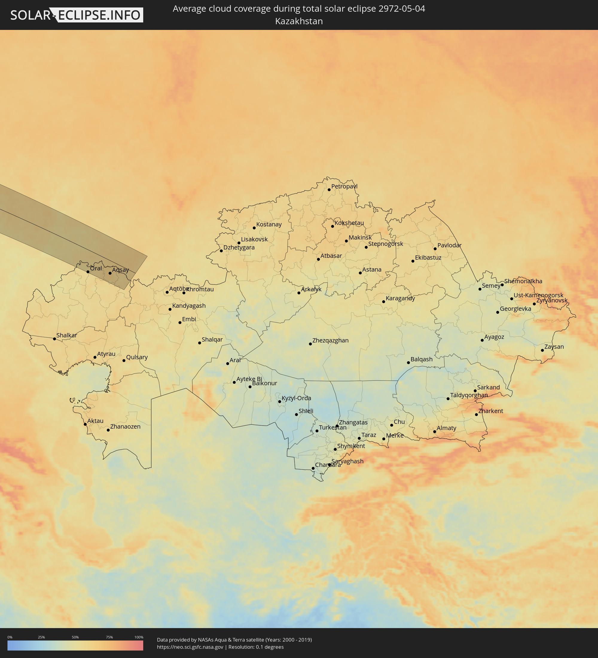
Wie wird das Wetter während der totalen Sonnenfinsternis am 04.05.2972?
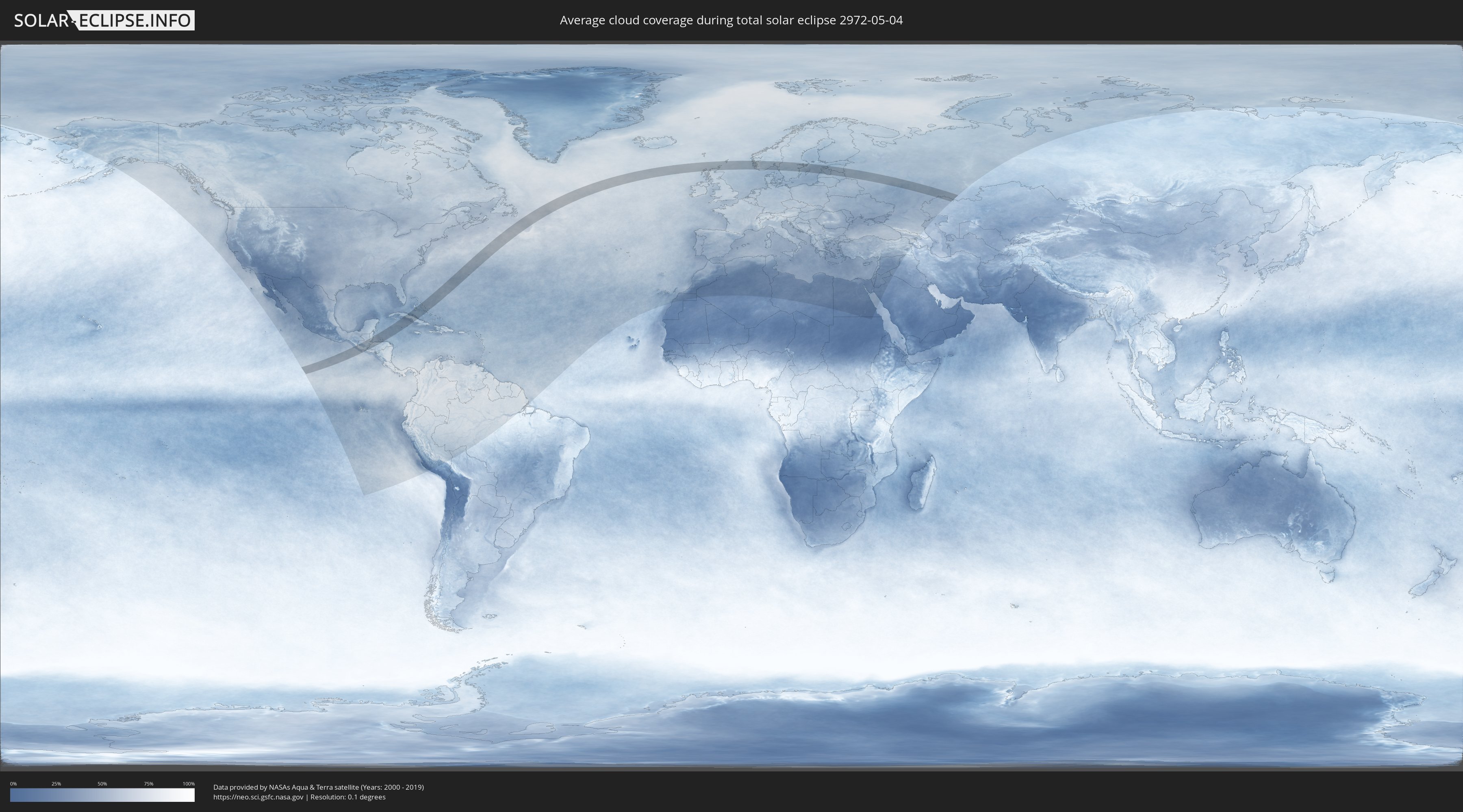
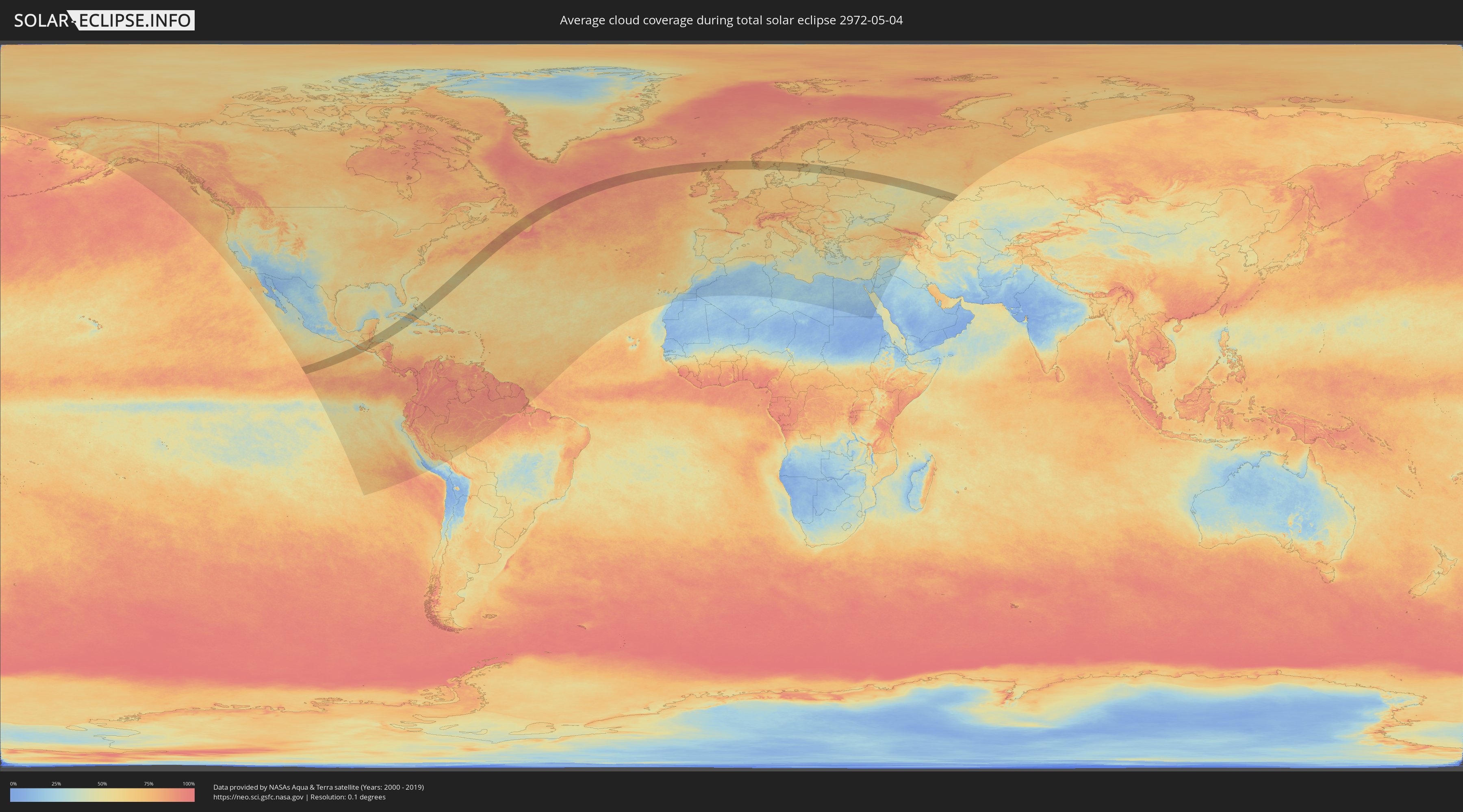
Wo ist der beste Ort, um die totale Sonnenfinsternis vom 04.05.2972 zu beobachten?
Die folgenden Karten zeigen die durchschnittliche Bewölkung für den Tag, an dem die totale Sonnenfinsternis
stattfindet. Mit Hilfe der Karten lässt sich der Ort entlang des Finsternispfades eingrenzen,
der die besten Aussichen auf einen klaren wolkenfreien Himmel bietet.
Trotzdem muss man immer lokale Gegenenheiten beachten und sollte sich genau über das Wetter an seinem
gewählten Beobachtungsort informieren.
Die Daten stammen von den beiden NASA-Satelliten
AQUA und TERRA
und wurden über einen Zeitraum von 19 Jahren (2000 - 2019) gemittelt.
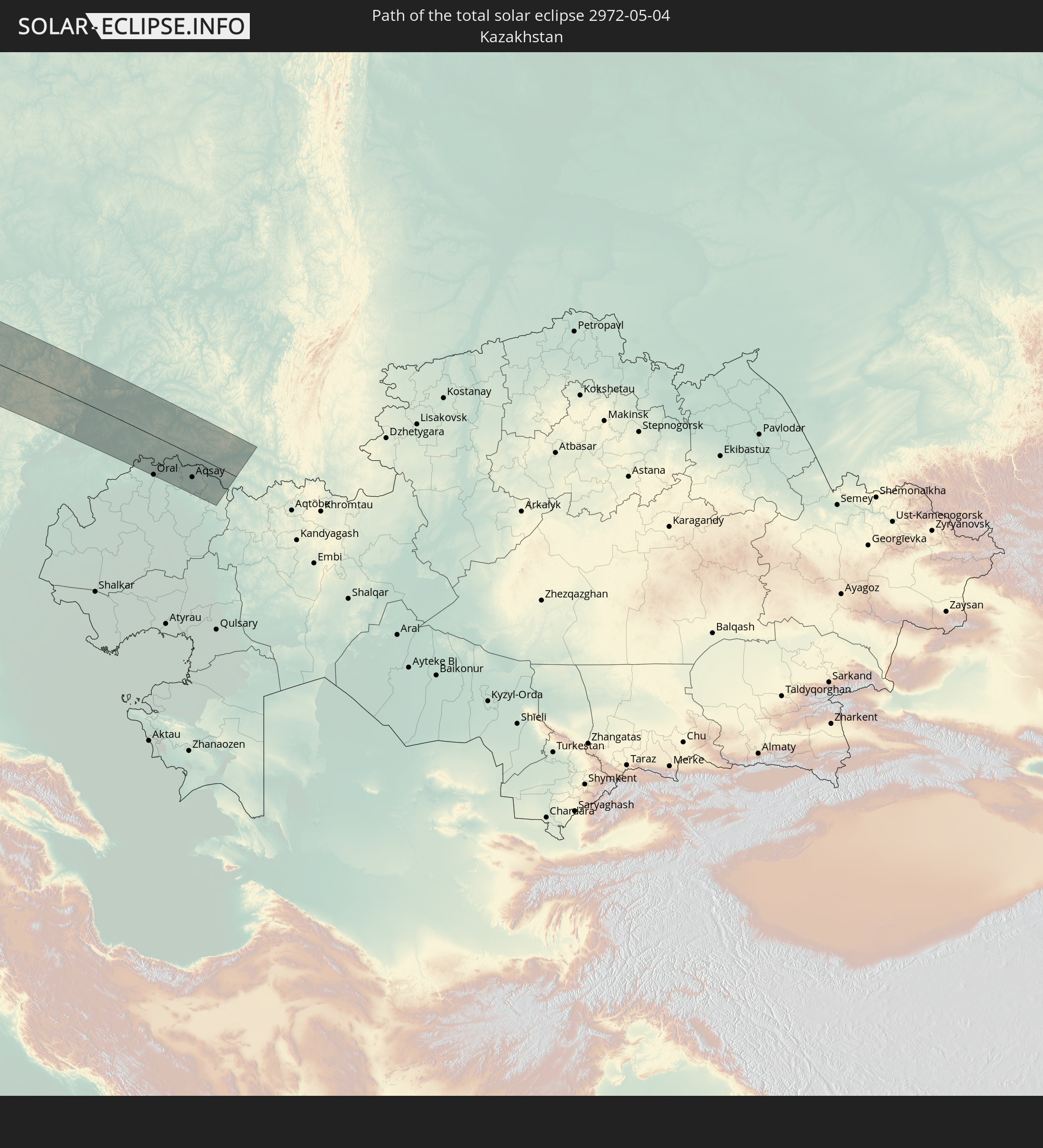
Detaillierte Länderkarten
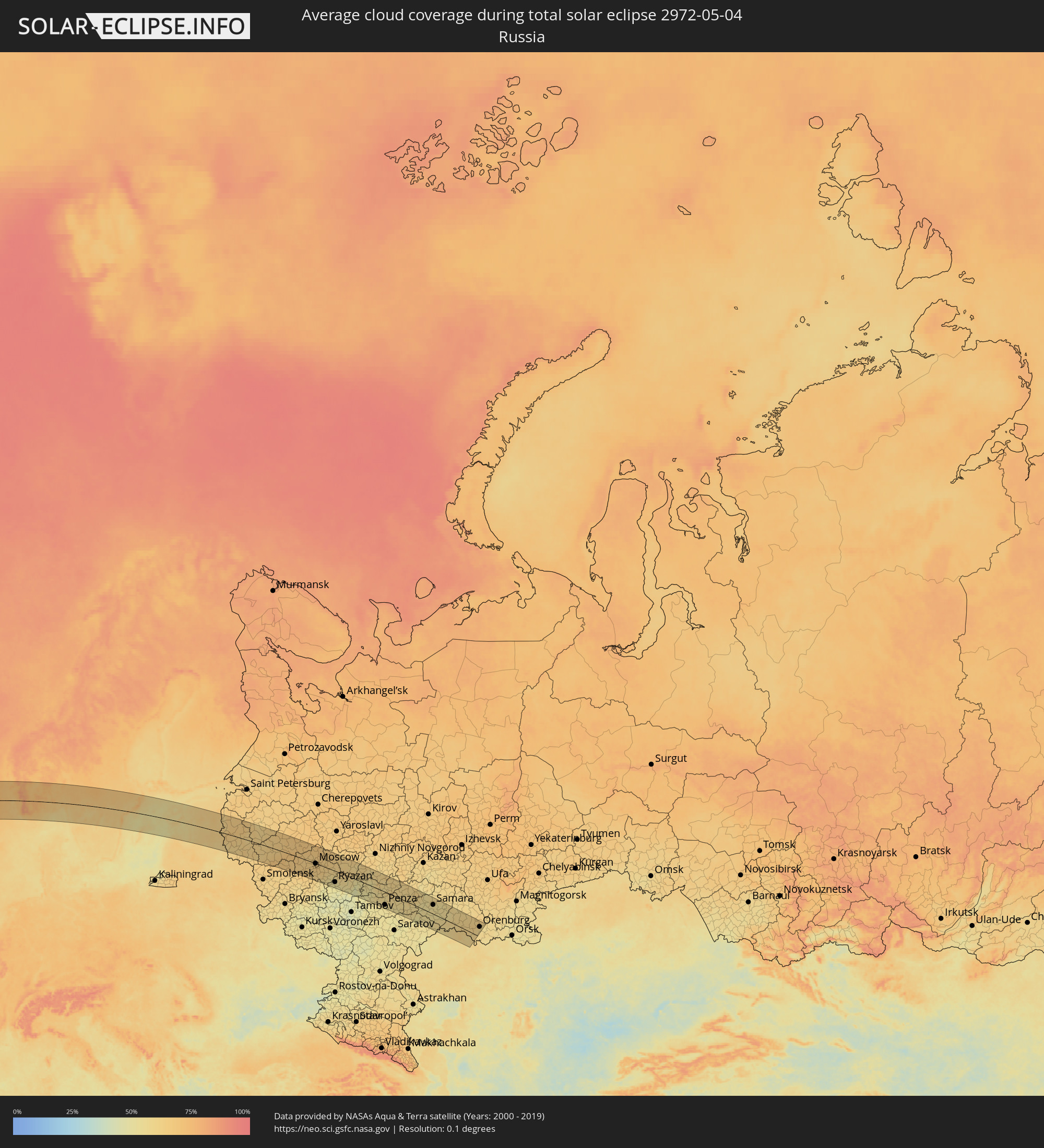 Russland
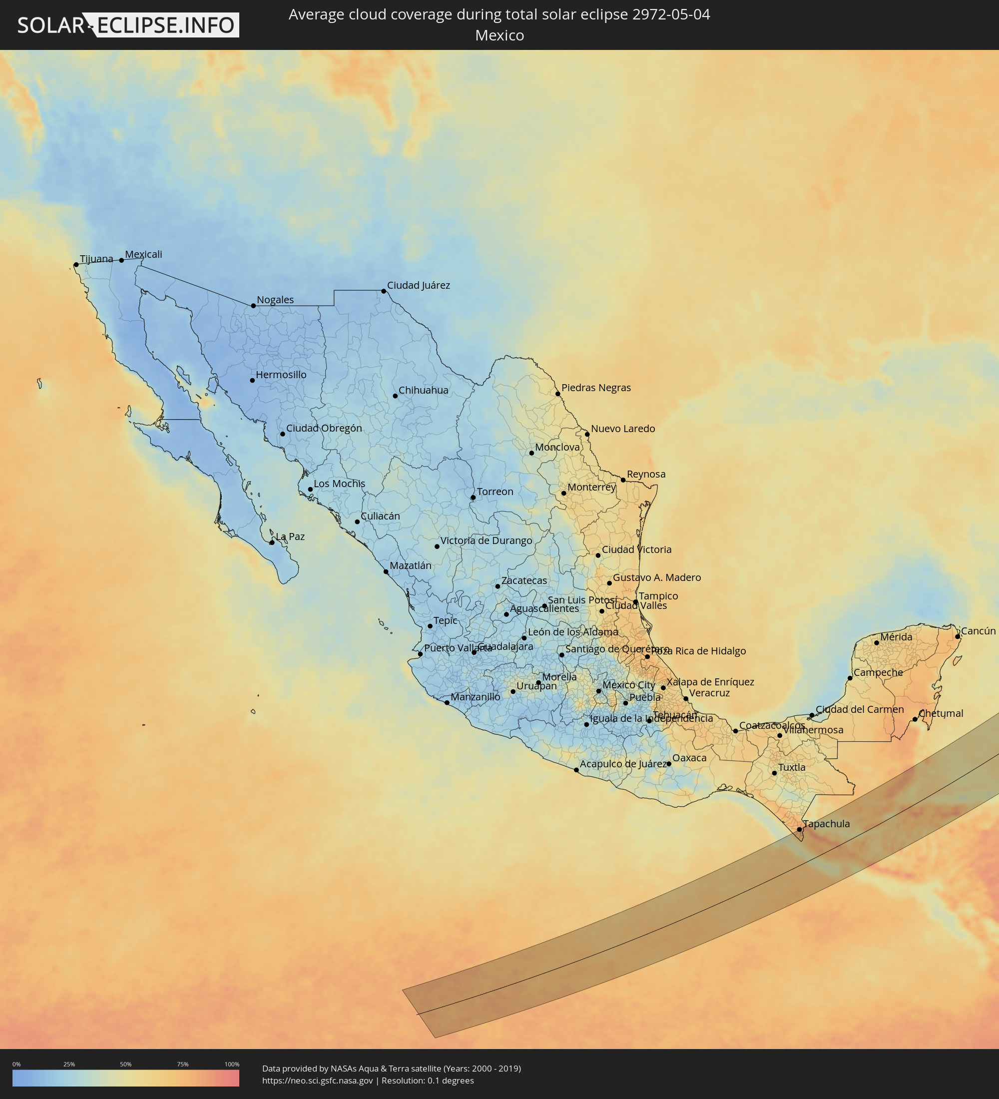 Mexiko
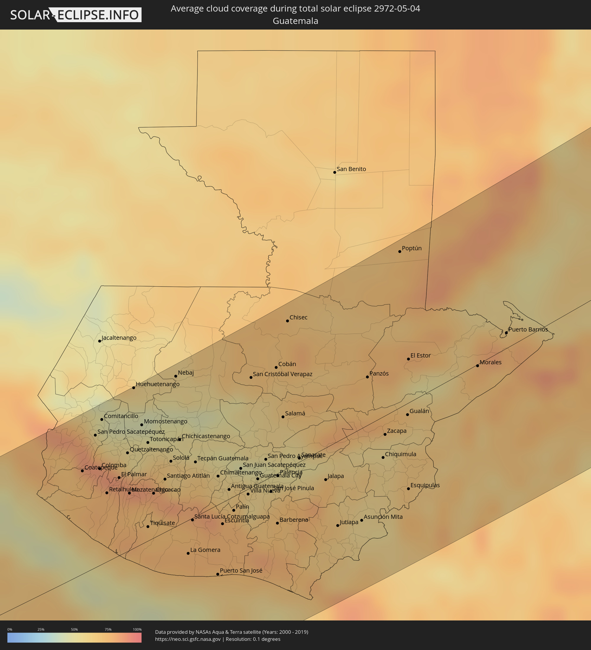 Guatemala
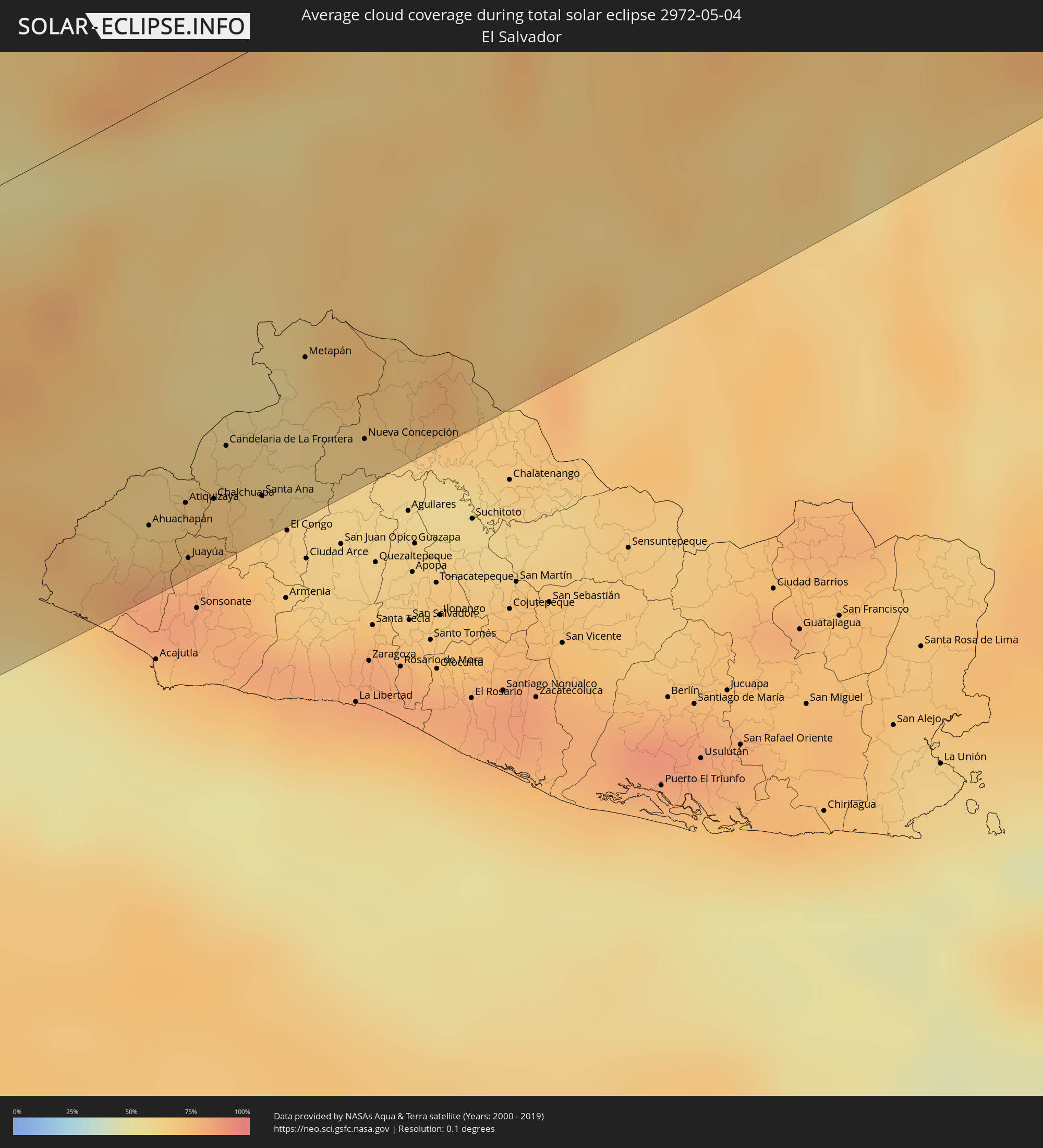 El Salvador
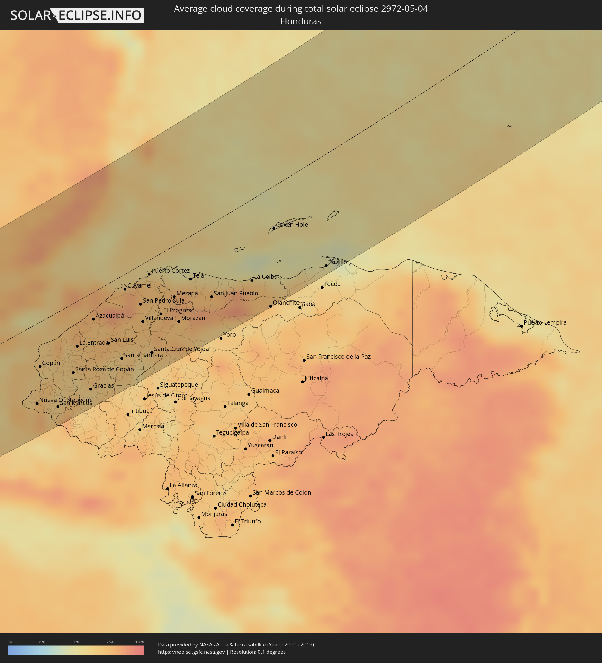 Honduras
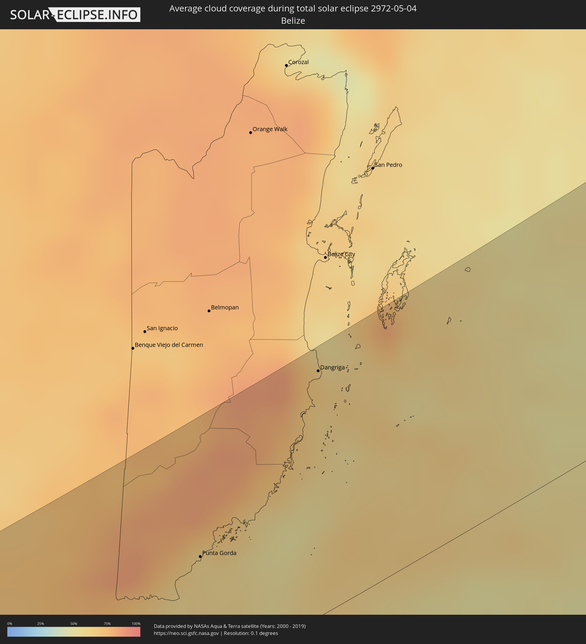 Belize
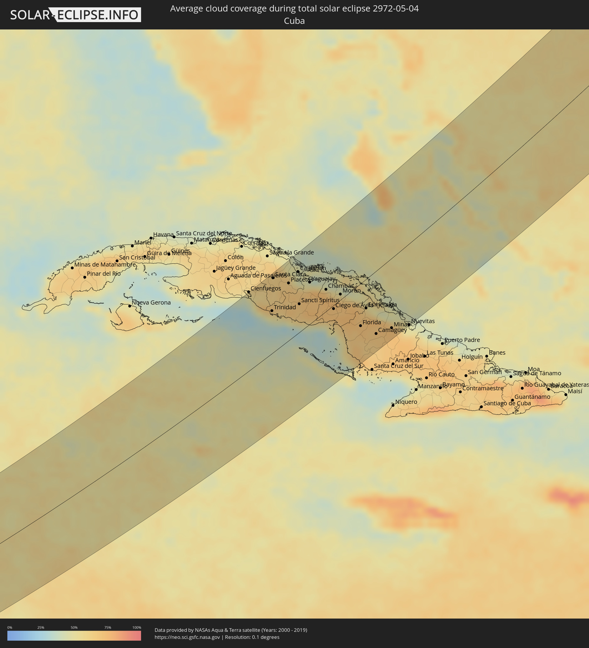 Kuba
Kuba
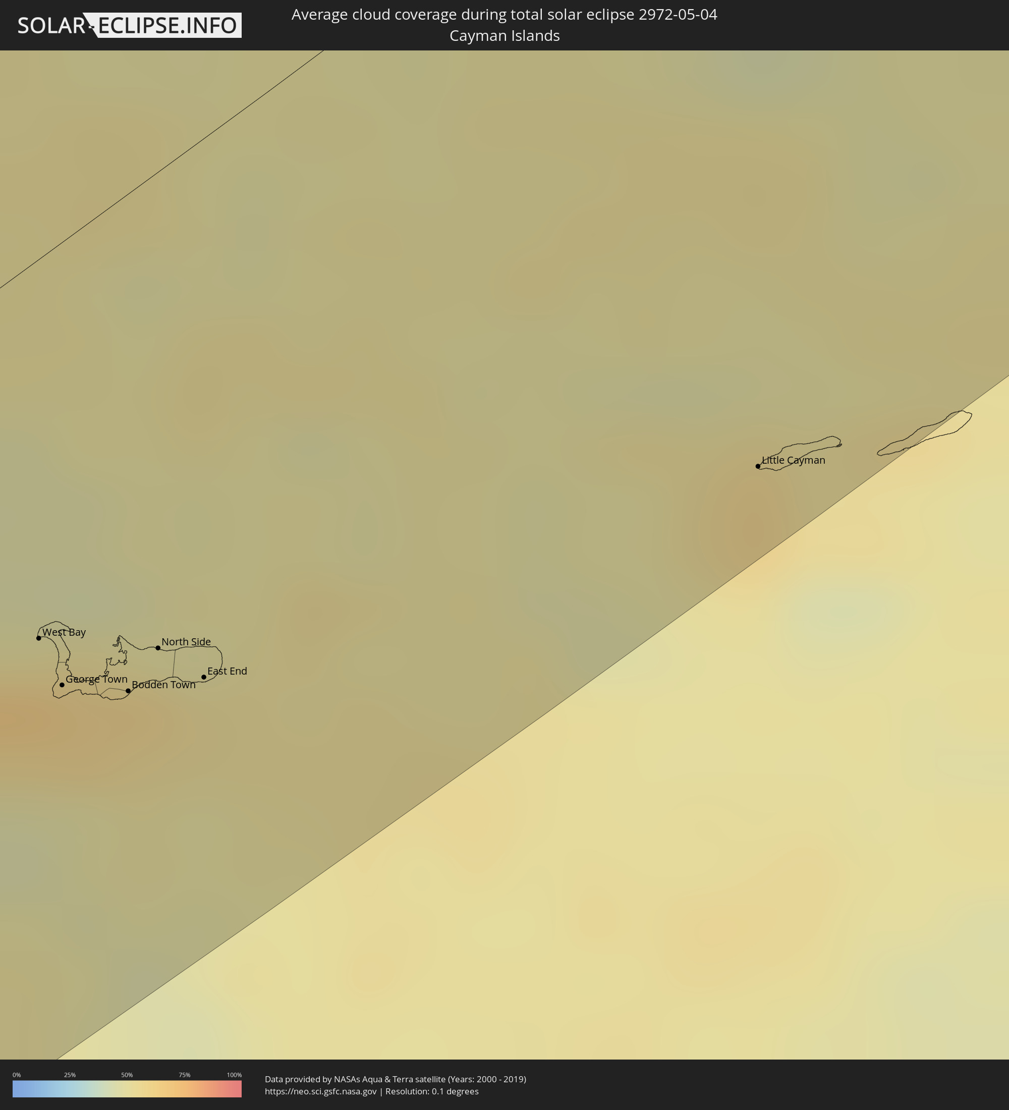 Kaimaninseln
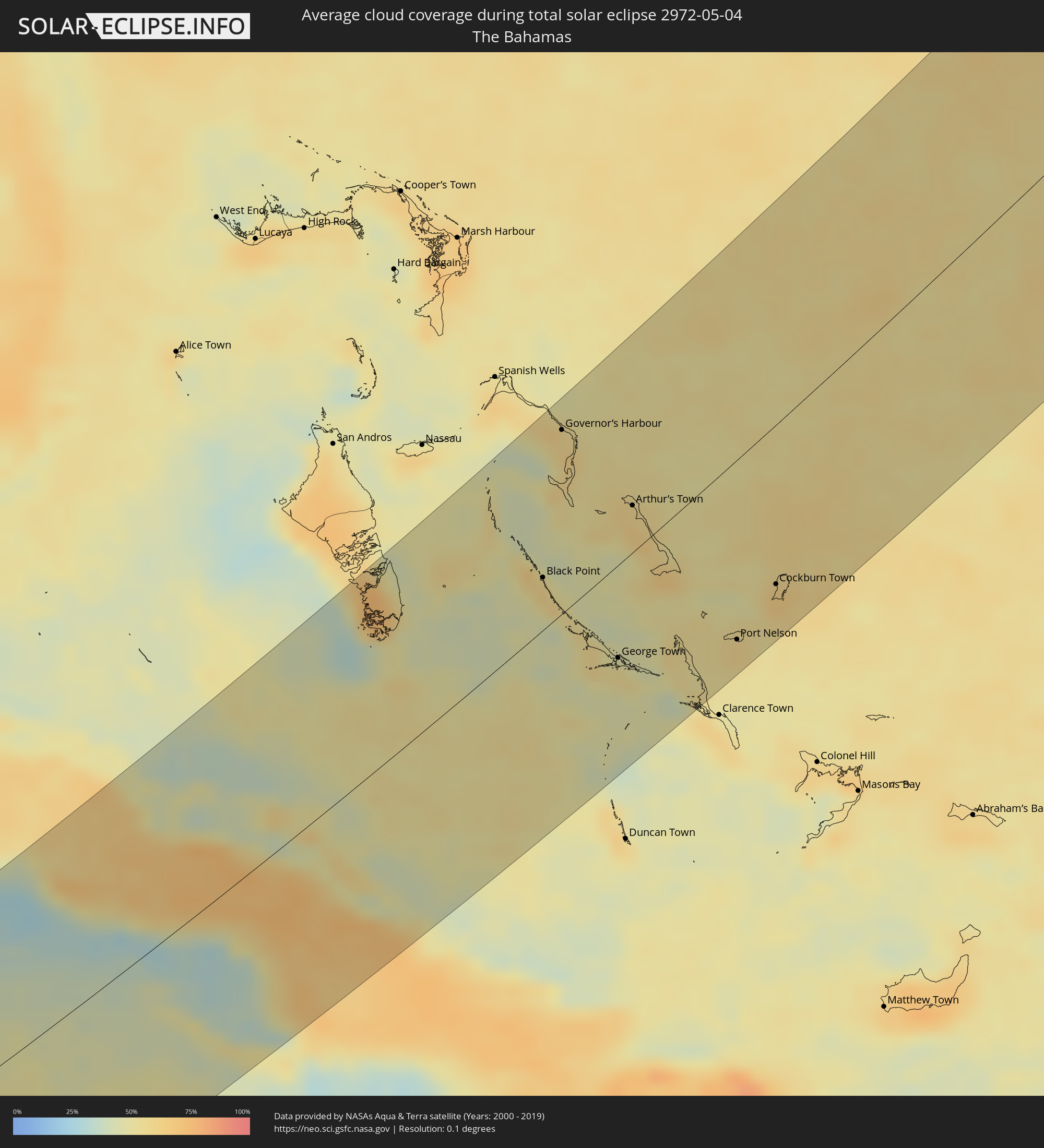 Bahamas
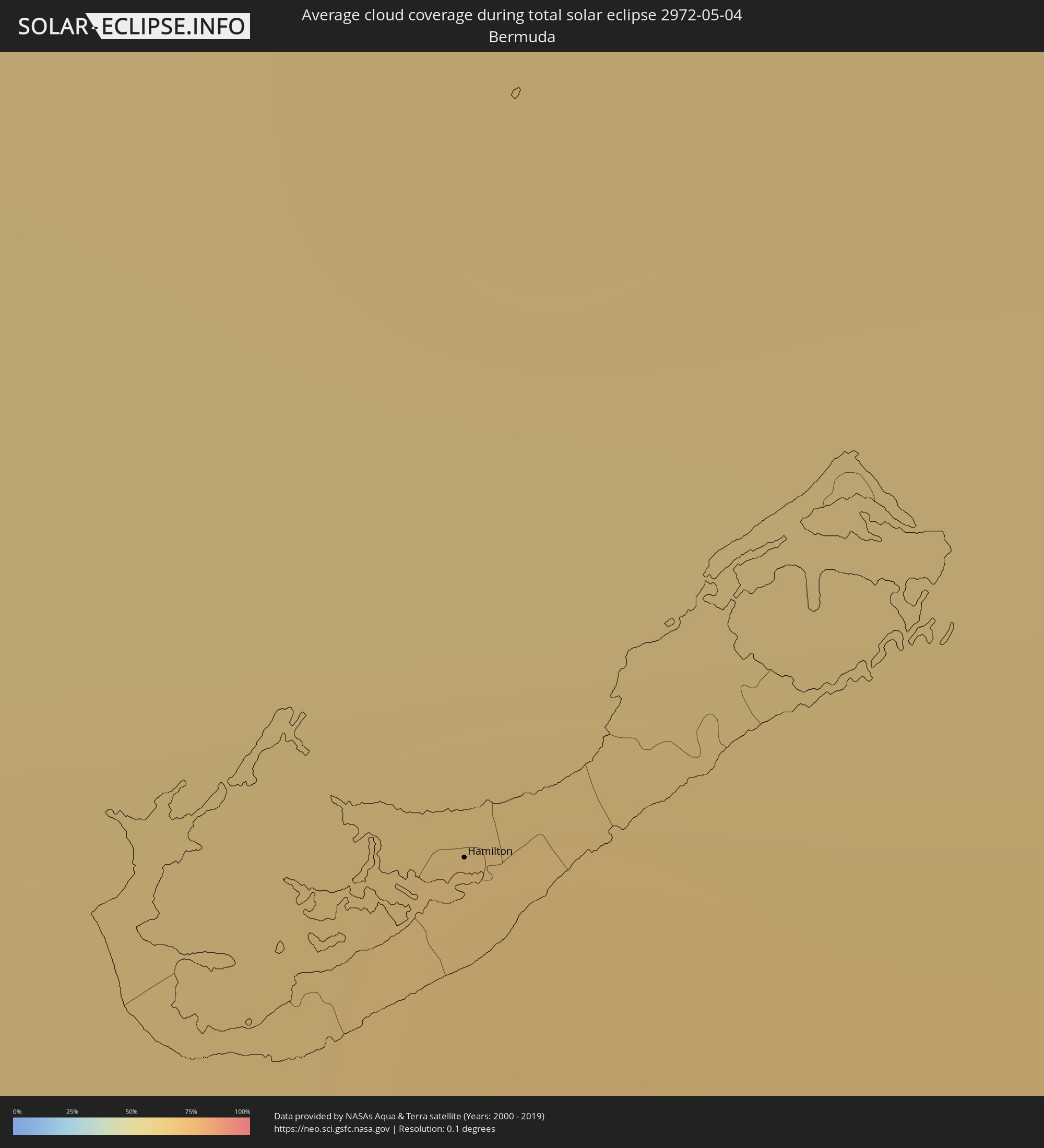 Bermuda
 Vereinigtes Königreich
 Norwegen
 Schweden
 Lettland
 Estland
 Kasachstan
Orte im Finsternispfad
Die nachfolgene Tabelle zeigt Städte und Orte mit mehr als 5.000 Einwohnern, die sich im Finsternispfad befinden. Städte mit mehr als 100.000 Einwohnern sind dick gekennzeichnet. Mit einem Klick auf den Ort öffnet sich eine Detailkarte die die Lage des jeweiligen Ortes zusammen mit dem Verlauf der zentralen Finsternis präsentiert.
| Ort | Typ | Dauer der Verfinsterung | Ortszeit bei maximaler Verfinsterung | Entfernung zur Zentrallinie | Ø Bewölkung |
|
Puerto Madero, Chiapas
|
total | - | 06:54:04 UTC-06:00 | 105 km | 58% |
|
Vida Mejor I, Chiapas
|
total | - | 06:54:16 UTC-06:00 | 115 km | 77% |
|
Tapachula, Chiapas
|
total | - | 06:54:19 UTC-06:00 | 116 km | 77% |
|
Brisas Barra de Suchiate, Chiapas
|
total | - | 06:53:51 UTC-06:00 | 77 km | 55% |
|
Tuxtla Chico, Chiapas
|
total | - | 06:54:22 UTC-06:00 | 115 km | 76% |
|
Quetzaltenango, Quetzaltenango
|
total | - | 06:54:17 UTC-06:00 | 73 km | 80% |
|
Huehuetenango, Huehuetenango
|
total | - | 06:54:55 UTC-06:00 | 118 km | 46% |
|
Totonicapán, Totonicapán
|
total | - | 06:54:24 UTC-06:00 | 73 km | 64% |
|
Chichicastenango, Quiché
|
total | - | 06:54:27 UTC-06:00 | 62 km | 64% |
|
Santa Lucía Cotzumalguapa, Escuintla
|
total | - | 06:53:41 UTC-06:00 | 2 km | 76% |
|
Chimaltenango, Chimaltenango
|
total | - | 06:54:07 UTC-06:00 | 21 km | 60% |
|
Escuintla, Escuintla
|
total | - | 06:53:40 UTC-06:00 | 16 km | 76% |
|
San Juan Sacatepéquez, Guatemala
|
total | - | 06:54:13 UTC-06:00 | 18 km | 61% |
|
Petapa, Guatemala
|
total | - | 06:53:56 UTC-06:00 | 8 km | 62% |
|
Guatemala City, Guatemala
|
total | - | 06:54:07 UTC-06:00 | 4 km | 62% |
|
San José Pinula, Guatemala
|
total | - | 06:54:01 UTC-06:00 | 11 km | 71% |
|
Cobán, Alta Verapaz
|
total | - | 06:55:14 UTC-06:00 | 78 km | 64% |
|
Tacuba, Ahuachapán
|
total | - | 06:53:14 UTC-06:00 | 99 km | 81% |
|
Concepción de Ataco, Ahuachapán
|
total | - | 06:53:12 UTC-06:00 | 106 km | 81% |
|
Ahuachapán, Ahuachapán
|
total | - | 06:53:16 UTC-06:00 | 101 km | 81% |
|
Atiquizaya, Ahuachapán
|
total | - | 06:53:21 UTC-06:00 | 100 km | 70% |
|
Juayúa, Sonsonate
|
total | - | 06:53:10 UTC-06:00 | 114 km | 81% |
|
Chalchuapa, Santa Ana
|
total | - | 06:53:22 UTC-06:00 | 103 km | 72% |
|
Candelaria de La Frontera, Santa Ana
|
total | - | 06:53:32 UTC-06:00 | 92 km | 69% |
|
Santa Ana, Santa Ana
|
total | - | 06:53:23 UTC-06:00 | 108 km | 69% |
|
Coatepeque, Santa Ana
|
total | - | 06:53:19 UTC-06:00 | 118 km | 66% |
|
Metapán, Santa Ana
|
total | - | 06:53:51 UTC-06:00 | 81 km | 60% |
|
Nueva Concepción, Chalatenango
|
total | - | 06:53:36 UTC-06:00 | 108 km | 61% |
|
Punta Gorda, Toledo
|
total | - | 06:56:18 UTC-06:00 | 58 km | 59% |
|
Santa Rosa de Copán, Copán
|
total | - | 06:54:31 UTC-06:00 | 73 km | 63% |
|
La Entrada, Copán
|
total | - | 06:54:54 UTC-06:00 | 48 km | 69% |
|
Puerto Barrios, Izabal
|
total | - | 06:55:50 UTC-06:00 | 11 km | 76% |
|
Santa Bárbara, Santa Bárbara
|
total | - | 06:54:48 UTC-06:00 | 86 km | 69% |
|
Dangriga, Stann Creek
|
total | - | 06:57:36 UTC-06:00 | 111 km | 64% |
|
Cofradía, Cortés
|
total | - | 06:55:28 UTC-06:00 | 44 km | 71% |
|
San Pedro Sula, Cortés
|
total | - | 06:55:37 UTC-06:00 | 41 km | 74% |
|
Villanueva, Cortés
|
total | - | 06:55:22 UTC-06:00 | 60 km | 71% |
|
Puerto Cortez, Cortés
|
total | - | 06:56:05 UTC-06:00 | 15 km | 71% |
|
El Progreso, Yoro
|
total | - | 06:55:31 UTC-06:00 | 63 km | 74% |
|
Morazán, Yoro
|
total | - | 06:55:27 UTC-06:00 | 82 km | 74% |
|
Tela, Atlántida
|
total | - | 06:56:06 UTC-06:00 | 45 km | 65% |
|
Santa Rita, Yoro
|
total | - | 06:55:18 UTC-06:00 | 113 km | 63% |
|
La Ceiba, Atlántida
|
total | - | 06:56:13 UTC-06:00 | 83 km | 70% |
|
Olanchito, Yoro
|
total | - | 06:55:52 UTC-06:00 | 121 km | 65% |
|
West Bay, West Bay
|
total | - | 08:03:07 UTC-05:00 | 59 km | 63% |
|
George Town, George Town
|
total | - | 08:03:01 UTC-05:00 | 68 km | 57% |
|
Bodden Town, Bodden Town
|
total | - | 08:03:03 UTC-05:00 | 77 km | 58% |
|
North Side, North Side
|
total | - | 08:03:11 UTC-05:00 | 73 km | 58% |
|
East End, East End
|
total | - | 08:03:08 UTC-05:00 | 83 km | 53% |
|
Little Cayman, Sister Island
|
total | - | 08:04:07 UTC-05:00 | 113 km | 58% |
|
Trinidad, Sancti Spíritus
|
total | - | 08:07:35 UTC-05:00 | 69 km | 50% |
|
Manicaragua, Villa Clara
|
total | - | 08:08:09 UTC-05:00 | 99 km | 62% |
|
Santa Clara, Villa Clara
|
total | - | 08:08:34 UTC-05:00 | 121 km | 62% |
|
Placetas, Villa Clara
|
total | - | 08:08:34 UTC-05:00 | 93 km | 67% |
|
Cabaiguán, Sancti Spíritus
|
total | - | 08:08:16 UTC-05:00 | 62 km | 67% |
|
Caibarién, Villa Clara
|
total | - | 08:09:00 UTC-05:00 | 99 km | 51% |
|
Sancti Spíritus, Sancti Spíritus
|
total | - | 08:08:03 UTC-05:00 | 46 km | 66% |
|
Yaguajay, Sancti Spíritus
|
total | - | 08:08:48 UTC-05:00 | 67 km | 70% |
|
Ciego de Ávila, Ciego de Ávila
|
total | - | 08:08:14 UTC-05:00 | 6 km | 71% |
|
Morón, Ciego de Ávila
|
total | - | 08:08:45 UTC-05:00 | 9 km | 69% |
|
Florida, Camagüey
|
total | - | 08:08:00 UTC-05:00 | 68 km | 70% |
|
Camagüey, Camagüey
|
total | - | 08:07:56 UTC-05:00 | 100 km | 67% |
|
Nuevitas, Camagüey
|
total | - | 08:08:33 UTC-05:00 | 128 km | 53% |
|
Black Point, Black Point
|
total | - | 13:13:19 UTC+00:00 | 32 km | 60% |
|
Governor’s Harbour, Central Eleuthera
|
total | - | 13:15:14 UTC+00:00 | 111 km | 58% |
|
George Town, Exuma
|
total | - | 08:12:41 UTC-05:00 | 57 km | 53% |
|
Arthur’s Town, Cat Island
|
total | - | 08:14:39 UTC-05:00 | 28 km | 62% |
|
Port Nelson, Rum Cay
|
total | - | 08:13:30 UTC-05:00 | 109 km | 52% |
|
Cockburn Town, San Salvador
|
total | - | 08:14:24 UTC-05:00 | 96 km | 63% |
|
Hamilton, Hamilton city
|
total | - | 09:37:34 UTC-04:00 | 112 km | 65% |
|
Isle of Lewis, Scotland
|
total | - | 15:18:55 UTC+00:00 | 88 km | 78% |
|
Stornoway, Scotland
|
total | - | 15:18:56 UTC+00:00 | 89 km | 78% |
|
Thurso, Scotland
|
total | - | 15:21:02 UTC+00:00 | 66 km | 76% |
|
Wick, Scotland
|
total | - | 15:21:29 UTC+00:00 | 86 km | 80% |
|
Orkney, Scotland
|
total | - | 15:21:13 UTC+00:00 | 26 km | 78% |
|
Kirkwall, Scotland
|
total | - | 15:21:13 UTC+00:00 | 26 km | 78% |
|
Lerwick, Scotland
|
total | - | 15:21:43 UTC+00:00 | 96 km | 81% |
|
Shetland, Scotland
|
total | - | 15:21:43 UTC+00:00 | 96 km | 81% |
|
Haugesund, Rogaland
|
total | - | 16:26:36 UTC+01:00 | 6 km | 64% |
|
Bergen, Hordaland
|
total | - | 16:25:45 UTC+01:00 | 115 km | 70% |
|
Stavanger, Rogaland
|
total | - | 16:27:18 UTC+01:00 | 43 km | 66% |
|
Arendal, Aust-Agder
|
total | - | 16:29:35 UTC+01:00 | 92 km | 61% |
|
Skien, Telemark
|
total | - | 16:29:20 UTC+01:00 | 5 km | 67% |
|
Kongsberg, Buskerud
|
total | - | 16:28:54 UTC+01:00 | 46 km | 68% |
|
Drammen, Buskerud
|
total | - | 16:29:07 UTC+01:00 | 56 km | 70% |
|
Sandefjord, Vestfold
|
total | - | 16:29:44 UTC+01:00 | 12 km | 65% |
|
Tønsberg, Vestfold
|
total | - | 16:29:42 UTC+01:00 | 4 km | 65% |
|
Moss, Østfold
|
total | - | 16:29:40 UTC+01:00 | 24 km | 67% |
|
Oslo, Oslo
|
total | - | 16:29:13 UTC+01:00 | 78 km | 71% |
|
Fredrikstad, Østfold
|
total | - | 16:30:01 UTC+01:00 | 2 km | 67% |
|
Halden, Østfold
|
total | - | 16:30:21 UTC+01:00 | 6 km | 64% |
|
Uddevalla, Västra Götaland
|
total | - | 16:31:26 UTC+01:00 | 89 km | 63% |
|
Trollhättan, Västra Götaland
|
total | - | 16:31:40 UTC+01:00 | 94 km | 62% |
|
Karlstad, Värmland
|
total | - | 16:31:08 UTC+01:00 | 35 km | 66% |
|
Skövde, Västra Götaland
|
total | - | 16:32:20 UTC+01:00 | 72 km | 64% |
|
Örebro, Örebro
|
total | - | 16:32:01 UTC+01:00 | 36 km | 68% |
|
Linköping, Östergötland
|
total | - | 16:33:07 UTC+01:00 | 56 km | 63% |
|
Norrköping, Östergötland
|
total | - | 16:33:10 UTC+01:00 | 31 km | 64% |
|
Eskilstuna, Södermanland
|
total | - | 16:32:28 UTC+01:00 | 57 km | 65% |
|
Västerås, Västmanland
|
total | - | 16:32:13 UTC+01:00 | 85 km | 68% |
|
Södertälje, Stockholm
|
total | - | 16:33:06 UTC+01:00 | 48 km | 62% |
|
Upplands Väsby, Stockholm
|
total | - | 16:32:52 UTC+01:00 | 86 km | 65% |
|
Stockholm, Stockholm
|
total | - | 16:33:08 UTC+01:00 | 67 km | 61% |
|
Haninge, Stockholm
|
total | - | 16:33:20 UTC+01:00 | 50 km | 61% |
|
Ventspils, Ventspils
|
total | - | 17:36:34 UTC+02:00 | 106 km | 52% |
|
Kuressaare, Saare
|
total | - | 17:35:54 UTC+02:00 | 1 km | 62% |
|
Talsi, Talsu Rajons
|
total | - | 17:37:03 UTC+02:00 | 109 km | 65% |
|
Haapsalu, Lääne
|
total | - | 17:35:24 UTC+02:00 | 88 km | 57% |
|
Daugavgrīva, Riga
|
total | - | 17:37:43 UTC+02:00 | 111 km | 59% |
|
Pärnu, Pärnumaa
|
total | - | 17:36:19 UTC+02:00 | 41 km | 61% |
|
Limbaži, Limbažu Rajons
|
total | - | 17:37:23 UTC+02:00 | 50 km | 59% |
|
Rapla, Raplamaa
|
total | - | 17:35:40 UTC+02:00 | 112 km | 61% |
|
Sigulda, Sigulda
|
total | - | 17:37:49 UTC+02:00 | 87 km | 60% |
|
Cēsis, Cēsu Rajons
|
total | - | 17:37:45 UTC+02:00 | 64 km | 61% |
|
Valmiera, Valmieras Rajons
|
total | - | 17:37:32 UTC+02:00 | 37 km | 61% |
|
Türi, Järvamaa
|
total | - | 17:36:04 UTC+02:00 | 100 km | 62% |
|
Paide, Järvamaa
|
total | - | 17:36:01 UTC+02:00 | 110 km | 62% |
|
Viljandi, Viljandimaa
|
total | - | 17:36:38 UTC+02:00 | 54 km | 65% |
|
Smiltene, Smiltene
|
total | - | 17:37:47 UTC+02:00 | 42 km | 63% |
|
Valka, Valkas Rajons
|
total | - | 17:37:25 UTC+02:00 | 3 km | 61% |
|
Valga, Valgamaa
|
total | - | 17:37:25 UTC+02:00 | 2 km | 61% |
|
Madona, Madonas Rajons
|
total | - | 17:38:31 UTC+02:00 | 99 km | 61% |
|
Jõgeva, Jõgevamaa
|
total | - | 17:36:23 UTC+02:00 | 107 km | 64% |
|
Elva, Tartu
|
total | - | 17:37:00 UTC+02:00 | 51 km | 63% |
|
Tartu, Tartu
|
total | - | 17:36:53 UTC+02:00 | 73 km | 67% |
|
Gulbene, Gulbenes Rajons
|
total | - | 17:38:16 UTC+02:00 | 56 km | 62% |
|
Võru, Võrumaa
|
total | - | 17:37:35 UTC+02:00 | 19 km | 62% |
|
Põlva, Põlvamaa
|
total | - | 17:37:20 UTC+02:00 | 44 km | 62% |
|
Balvi, Balvu Rajons
|
total | - | 17:38:27 UTC+02:00 | 53 km | 60% |
|
Ludza, Ludzas Rajons
|
total | - | 17:39:13 UTC+02:00 | 109 km | 60% |
|
Pskov, Pskov
|
total | - | 18:37:53 UTC+03:00 | 38 km | 64% |
|
Tver, Tverskaya
|
total | - | 18:39:59 UTC+03:00 | 78 km | 67% |
|
Zelenograd, Moscow
|
total | - | 18:41:03 UTC+03:00 | 14 km | 65% |
|
Khimki, Moscow Oblast
|
total | - | 18:41:09 UTC+03:00 | 10 km | 64% |
|
Moscow, Moscow
|
total | - | 18:41:19 UTC+03:00 | 1 km | 67% |
|
Ryazan’, Rjazan
|
total | - | 18:42:35 UTC+03:00 | 70 km | 53% |
|
Vladimir, Vladimir
|
total | - | 18:40:55 UTC+03:00 | 102 km | 62% |
|
Penza, Penza
|
total | - | 18:43:46 UTC+03:00 | 83 km | 54% |
|
Saransk, Mordoviya
|
total | - | 18:42:44 UTC+03:00 | 21 km | 57% |
|
Syzran’, Samara
|
total | - | 19:43:20 UTC+04:00 | 7 km | 58% |
|
Tol’yatti, Samara
|
total | - | 19:42:48 UTC+04:00 | 70 km | 56% |
|
Samara, Samara
|
total | - | 19:42:58 UTC+04:00 | 59 km | 54% |
|
Oral, Batys Qazaqstan
|
total | - | 20:44:37 UTC+05:00 | 102 km | 55% |
|
Fedorovka, Batys Qazaqstan
|
total | - | 20:44:29 UTC+05:00 | 86 km | 57% |
|
Aqsay, Batys Qazaqstan
|
total | - | 20:44:17 UTC+05:00 | 59 km | 64% |
|
Chingirlau, Batys Qazaqstan
|
total | - | 20:44:03 UTC+05:00 | 33 km | 59% |
|
Orenburg, Orenburg
|
total | - | 20:43:09 UTC+05:00 | 66 km | 60% |