Totale Sonnenfinsternis vom 28.08.2975
| Wochentag: | Montag |
| Maximale Dauer der Verfinsterung: | 05m53s |
| Maximale Breite des Finsternispfades: | 231 km |
| Saroszyklus: | 170 |
| Bedeckungsgrad: | 100% |
| Magnitude: | 1.0709 |
| Gamma: | -0.0279 |
Wo kann man die Sonnenfinsternis vom 28.08.2975 sehen?

Die Sonnenfinsternis am 28.08.2975 kann man in 96 Ländern als partielle Sonnenfinsternis beobachten.
Der Finsternispfad verläuft durch 12 Länder. Nur in diesen Ländern ist sie als totale Sonnenfinsternis zu sehen.
In den folgenden Ländern ist die Sonnenfinsternis total zu sehen
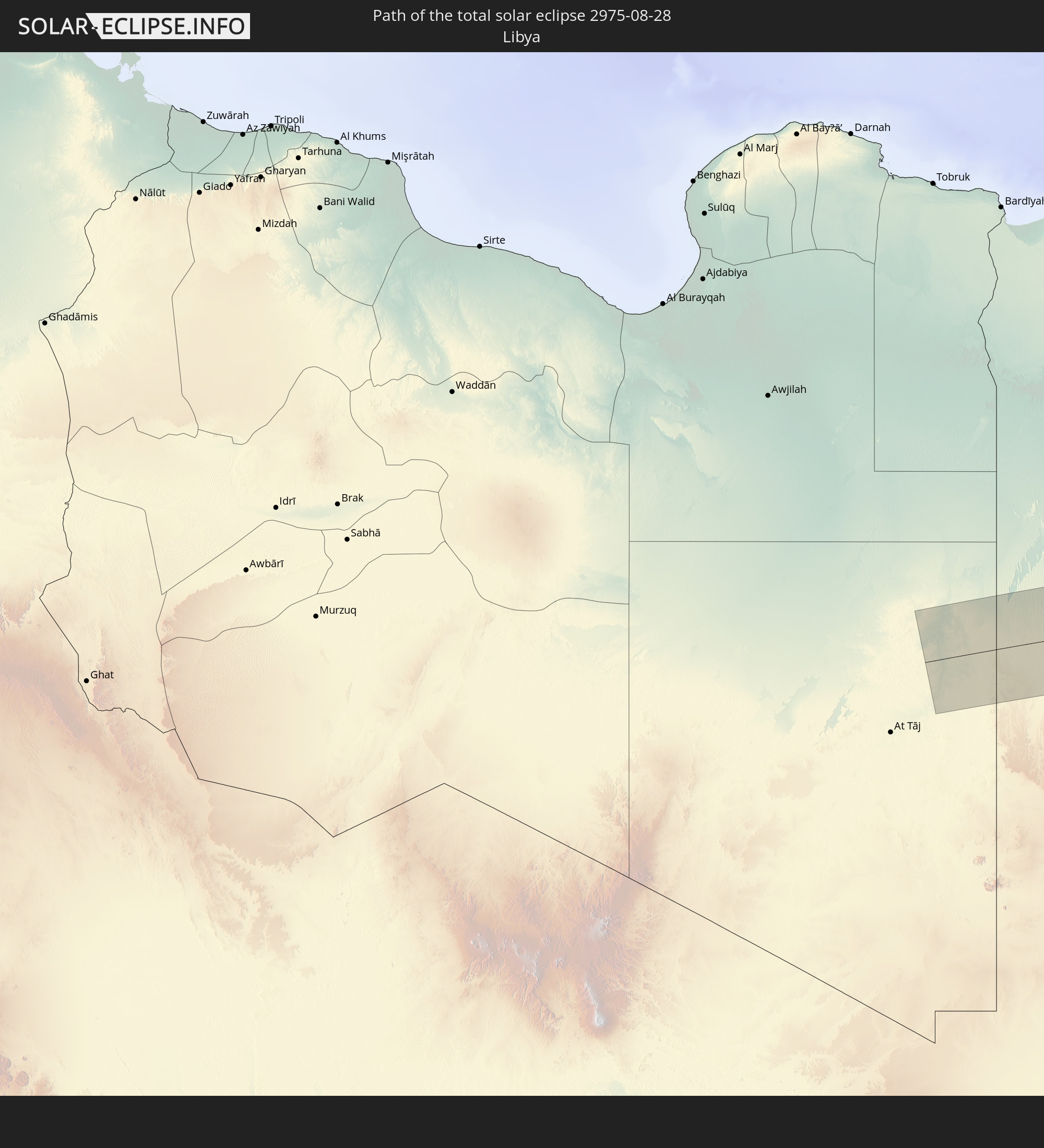 Libyen
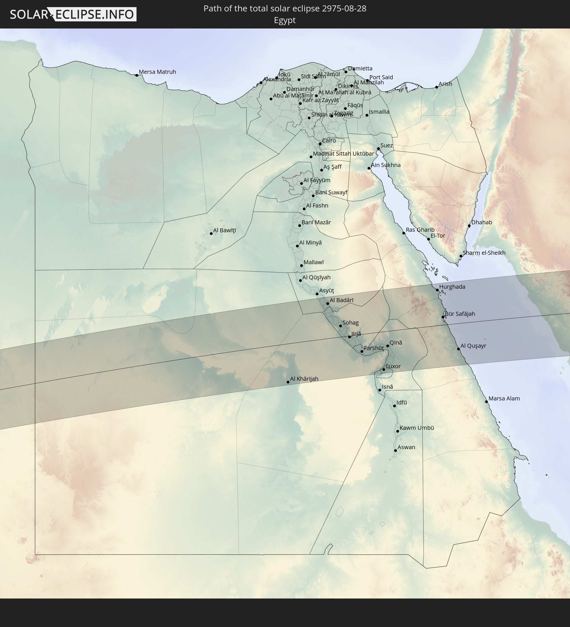 Ägypten
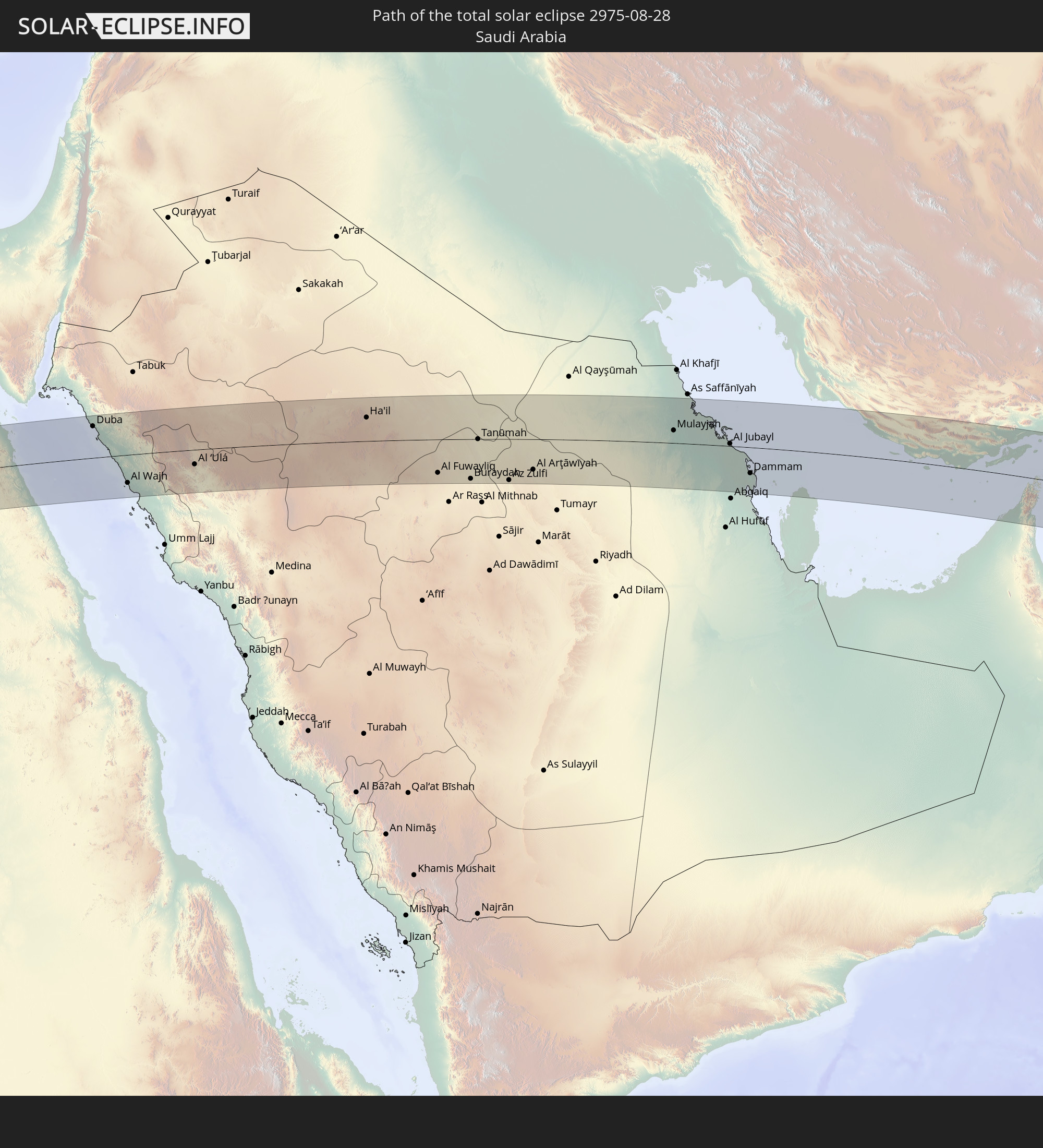 Saudi-Arabien
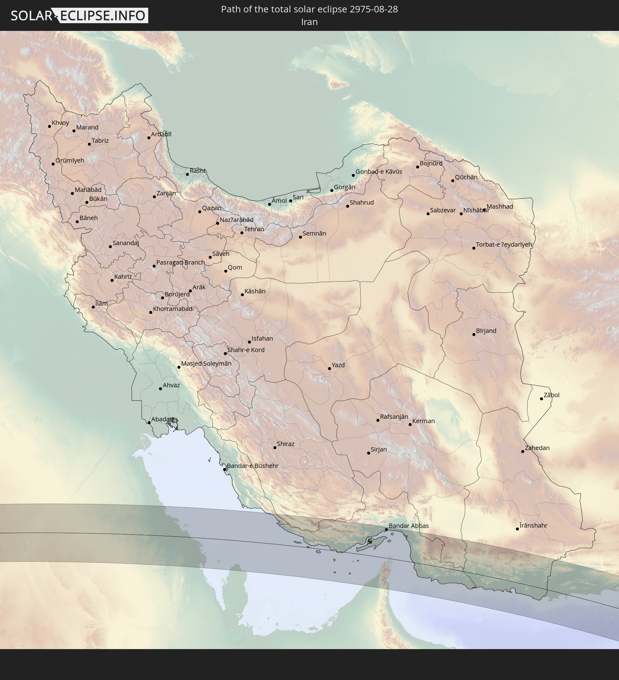 Iran
Iran
 Bahrain
 Katar
Katar
 Vereinigte Arabische Emirate
 Oman
Oman
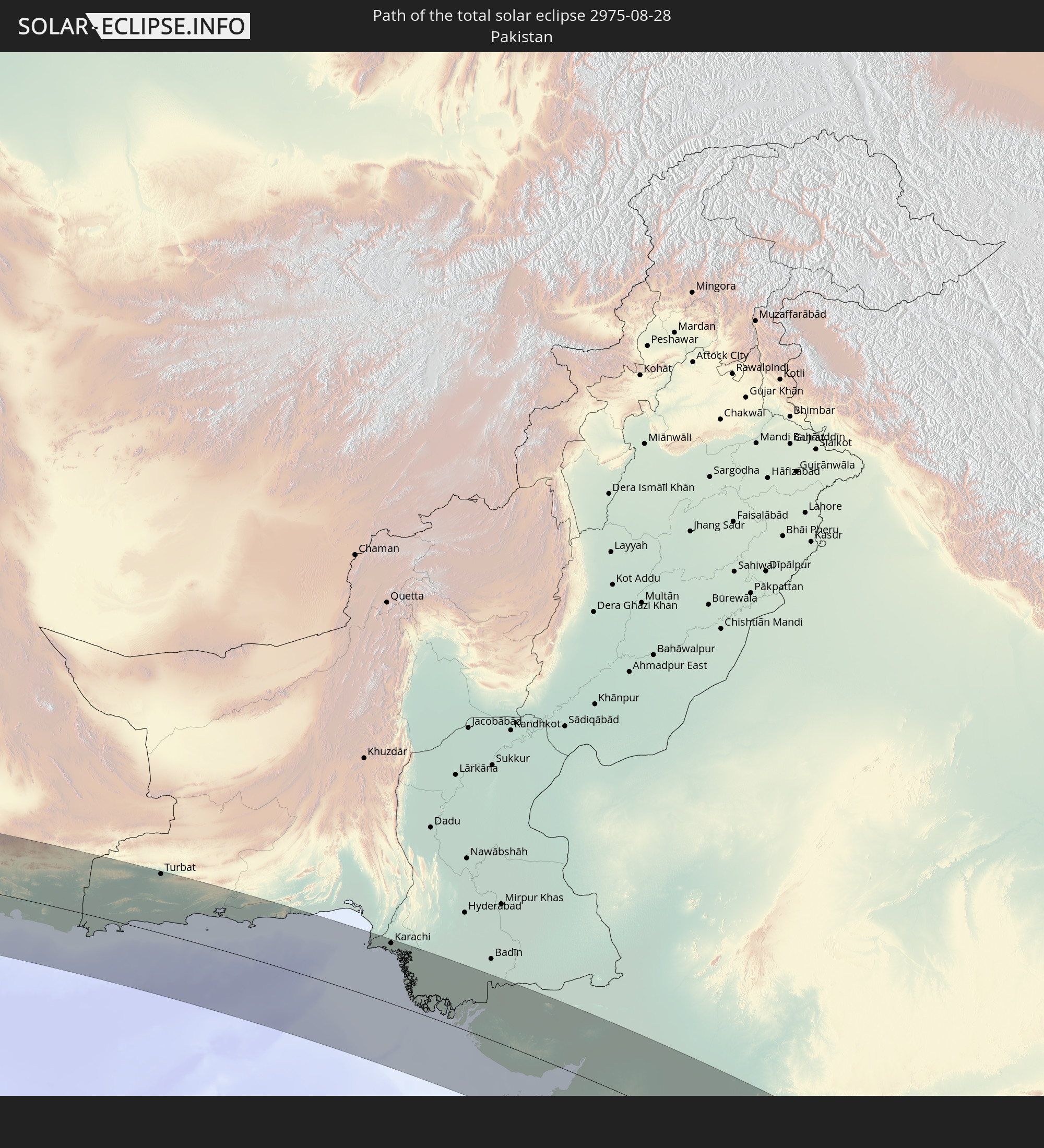 Pakistan
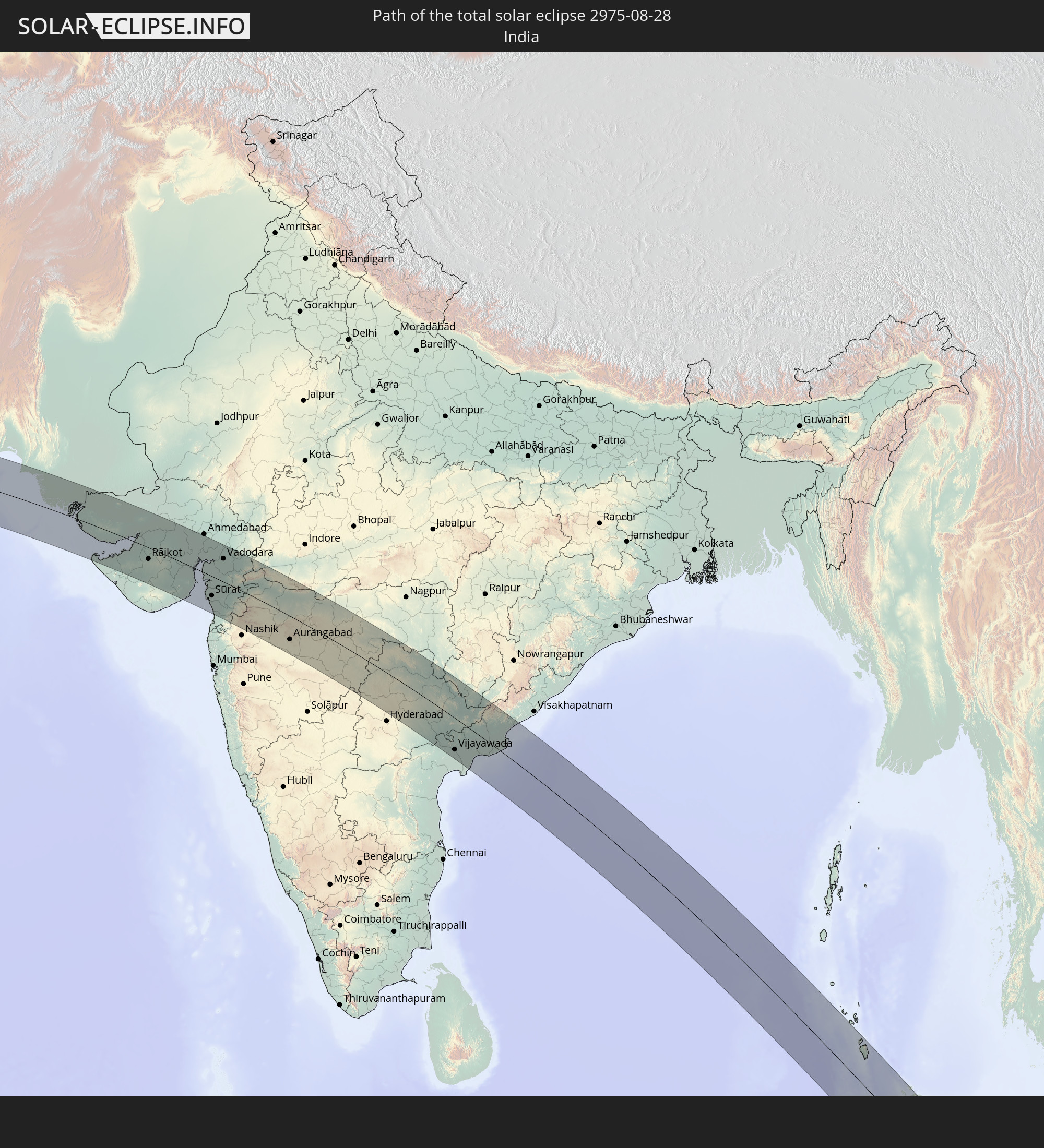 Indien
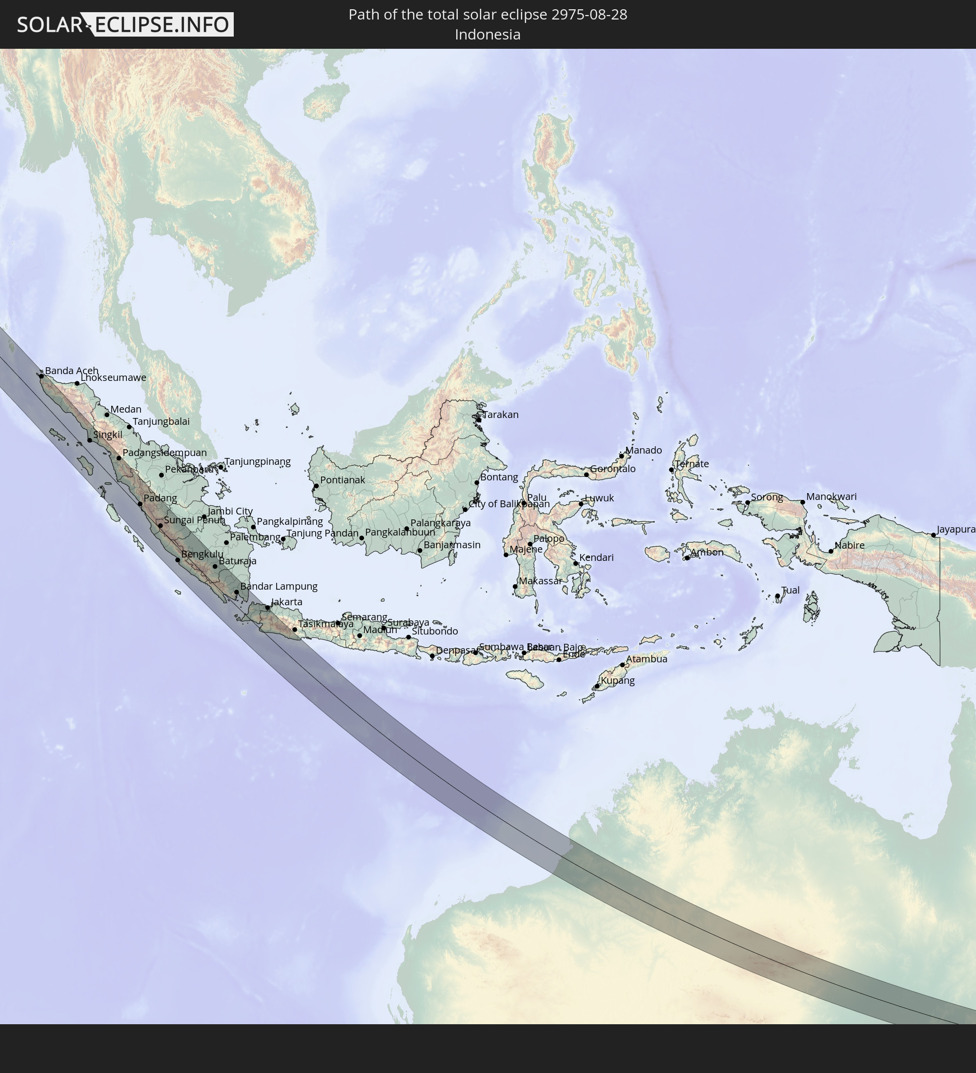 Indonesien
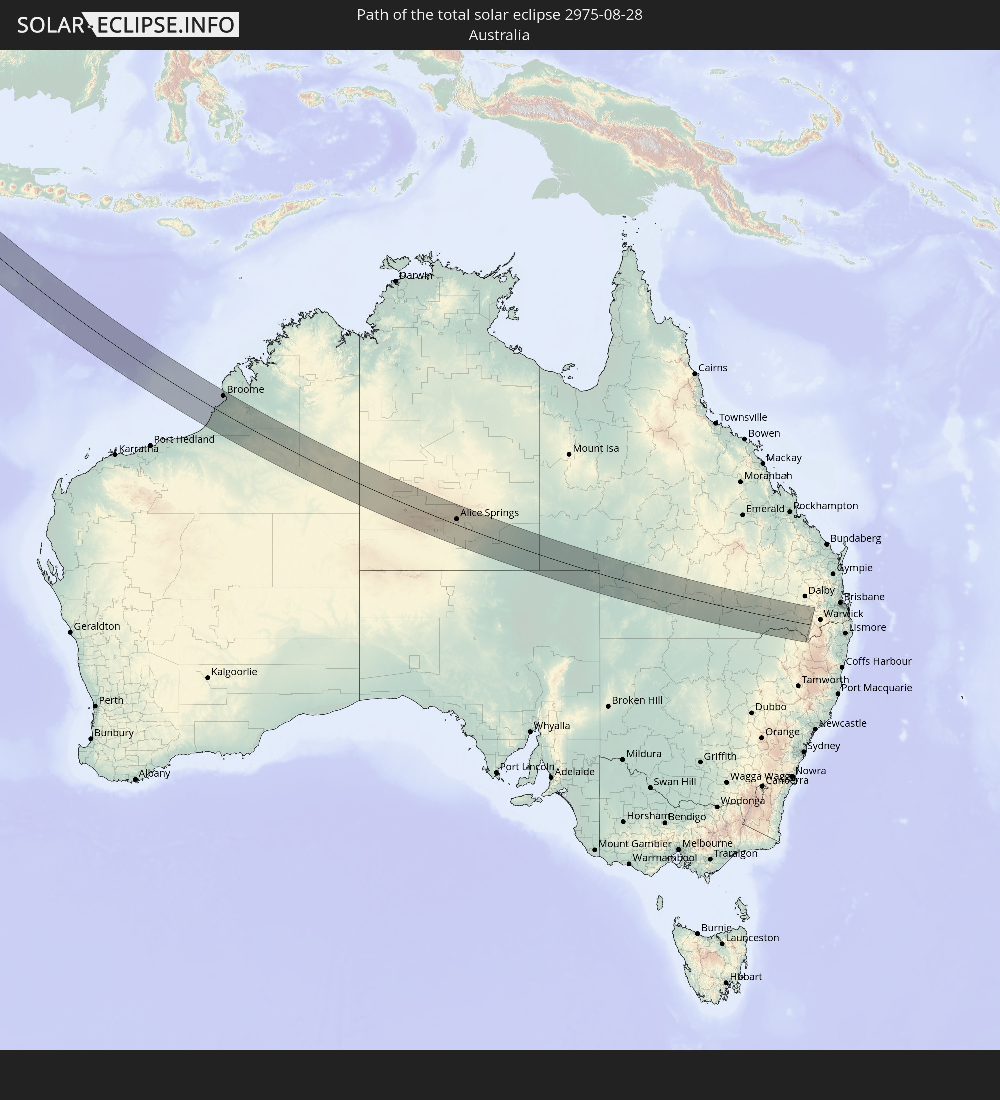 Australien
In den folgenden Ländern ist die Sonnenfinsternis partiell zu sehen
 Russland
 Deutschland
 Dänemark
 Libyen
 Österreich
 Schweden
 Tschechien
 Demokratische Republik Kongo
 Slowenien
 Kroatien
 Polen
Polen
 Zentralafrikanische Republik
 Bosnien und Herzegowina
 Ungarn
 Slowakei
 Montenegro
 Serbien
 Albanien
 Griechenland
 Rumänien
 Mazedonien
 Litauen
 Lettland
 Estland
 Sudan
Sudan
 Ukraine
 Bulgarien
 Weißrussland
 Ägypten
 Türkei
 Moldawien
 Ruanda
 Burundi
 Tansania
 Uganda
 Republik Zypern
 Äthiopien
 Kenia
Kenia
 Staat Palästina
 Israel
 Saudi-Arabien
 Jordanien
 Libanon
 Syrien
 Eritrea
 Irak
Irak
 Georgien
 Somalia
 Dschibuti
 Jemen
Jemen
 Armenien
 Iran
Iran
 Aserbaidschan
 Seychellen
 Kasachstan
 Kuwait
 Bahrain
 Katar
Katar
 Vereinigte Arabische Emirate
 Oman
Oman
 Turkmenistan
 Usbekistan
 Afghanistan
 Pakistan
 Tadschikistan
 Indien
 Kirgisistan
 Britisches Territorium im Indischen Ozean
 Malediven
 Volksrepublik China
 Sri Lanka
 Nepal
Nepal
 Mongolei
 Bangladesch
 Bhutan
 Myanmar
 Indonesien
 Kokosinseln
 Thailand
 Malaysia
 Laos
Laos
 Vietnam
 Kambodscha
 Singapur
 Weihnachtsinsel
 Australien
 Macau
Macau
 Hongkong
 Brunei
 Taiwan
 Philippinen
 Osttimor
 Palau
Palau
 Föderierte Staaten von Mikronesien
 Papua-Neuguinea
 Salomonen
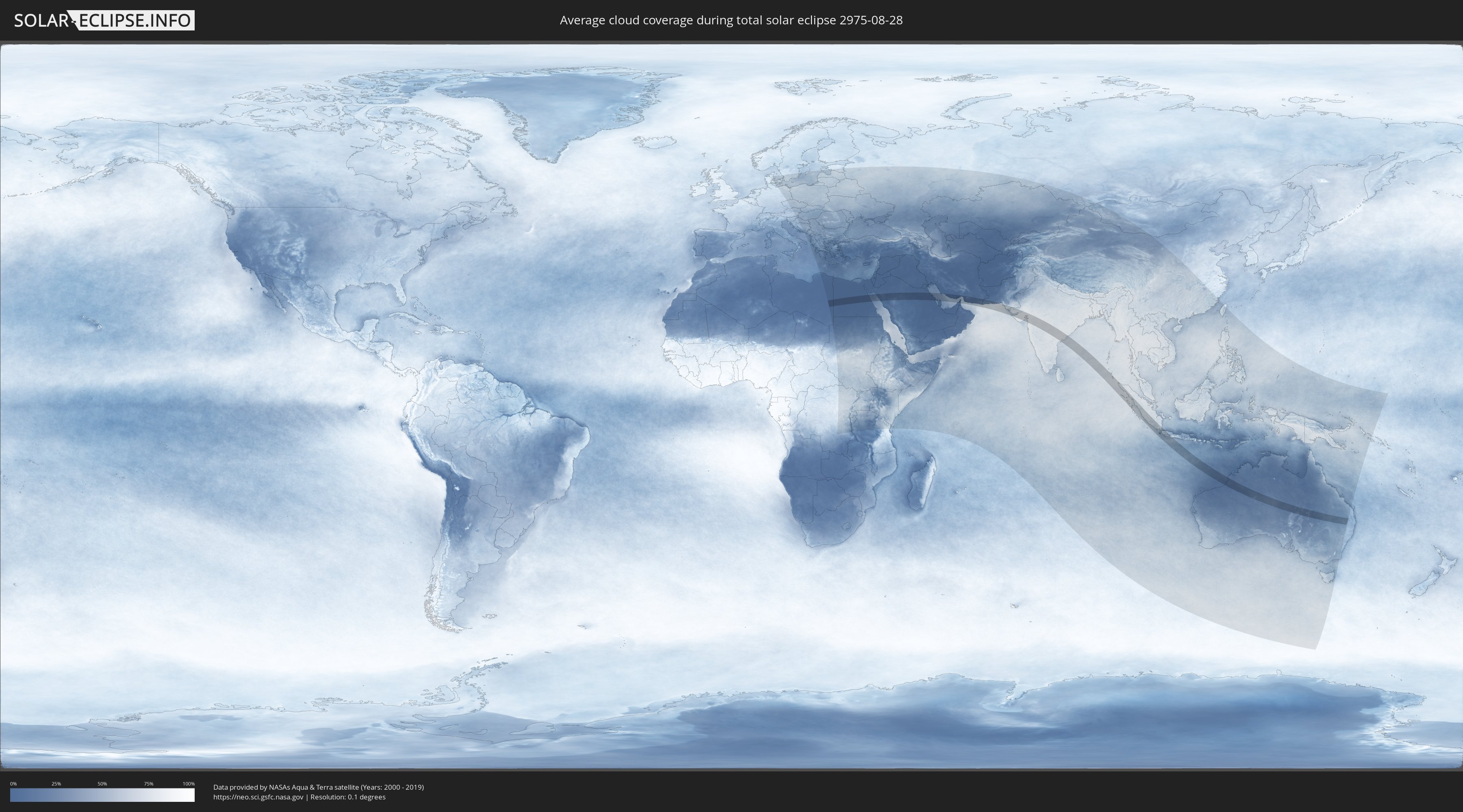
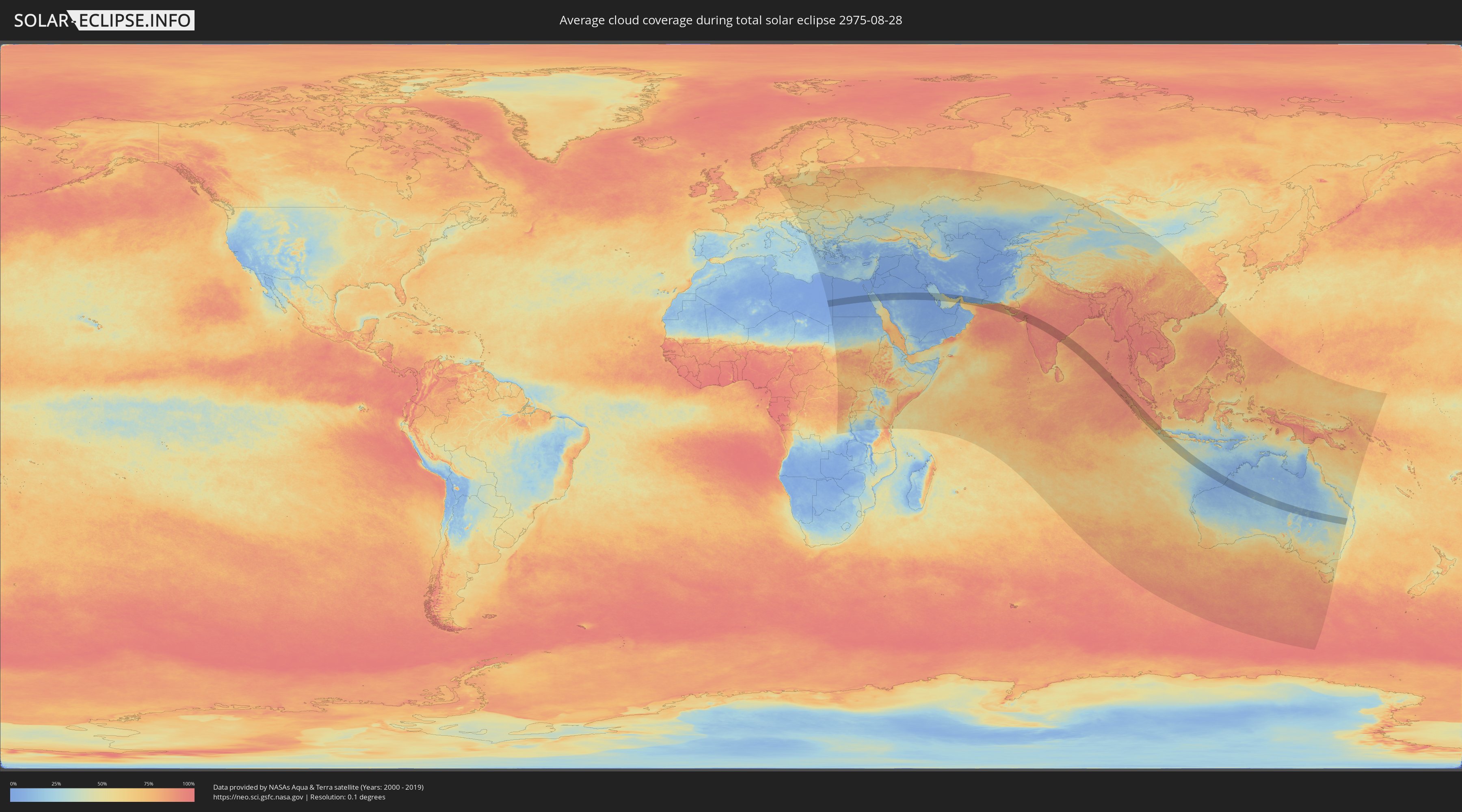
Wie wird das Wetter während der totalen Sonnenfinsternis am 28.08.2975?
Wo ist der beste Ort, um die totale Sonnenfinsternis vom 28.08.2975 zu beobachten?
Die folgenden Karten zeigen die durchschnittliche Bewölkung für den Tag, an dem die totale Sonnenfinsternis
stattfindet. Mit Hilfe der Karten lässt sich der Ort entlang des Finsternispfades eingrenzen,
der die besten Aussichen auf einen klaren wolkenfreien Himmel bietet.
Trotzdem muss man immer lokale Gegenenheiten beachten und sollte sich genau über das Wetter an seinem
gewählten Beobachtungsort informieren.
Die Daten stammen von den beiden NASA-Satelliten
AQUA und TERRA
und wurden über einen Zeitraum von 19 Jahren (2000 - 2019) gemittelt.
Detaillierte Länderkarten
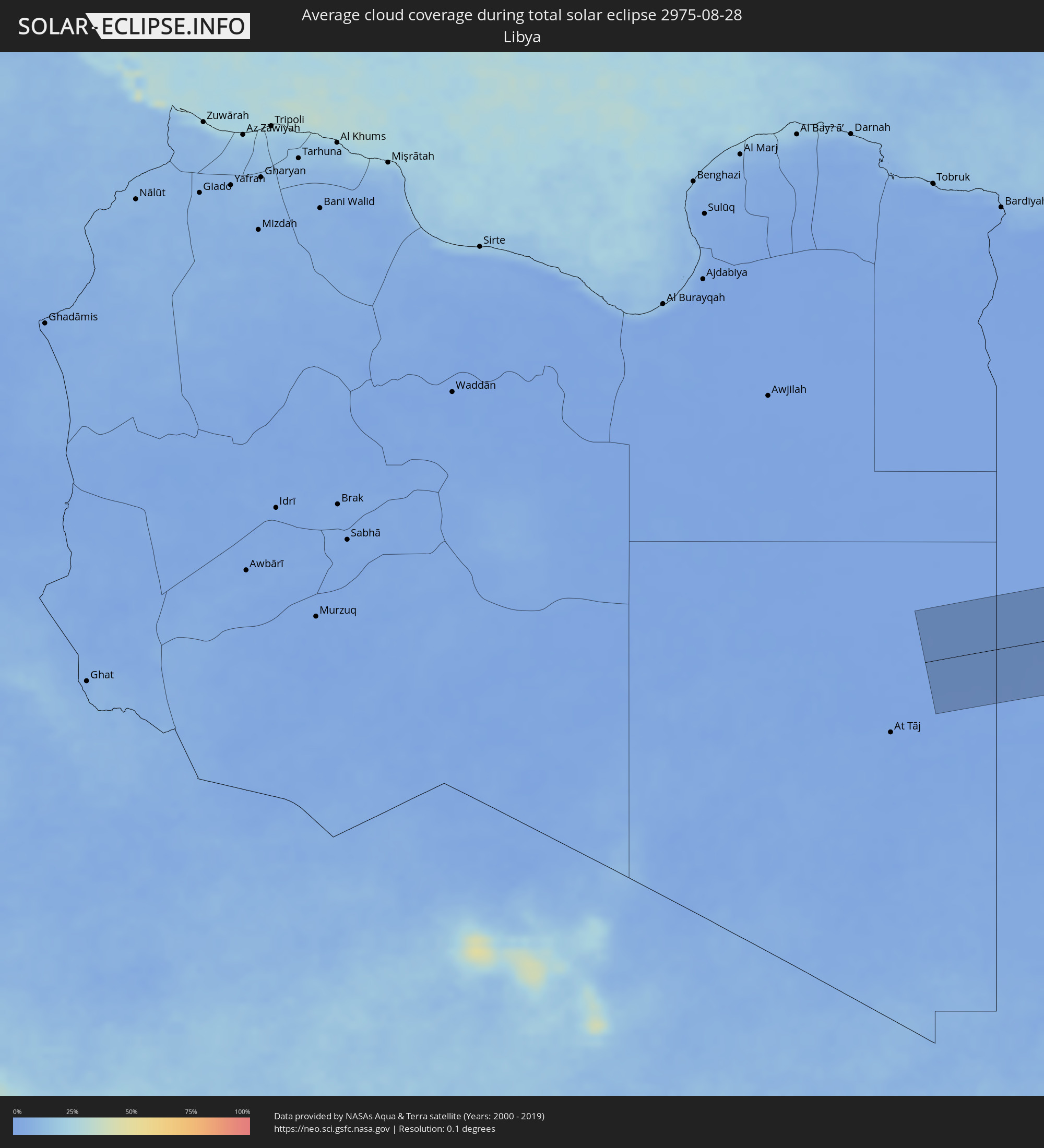 Libyen
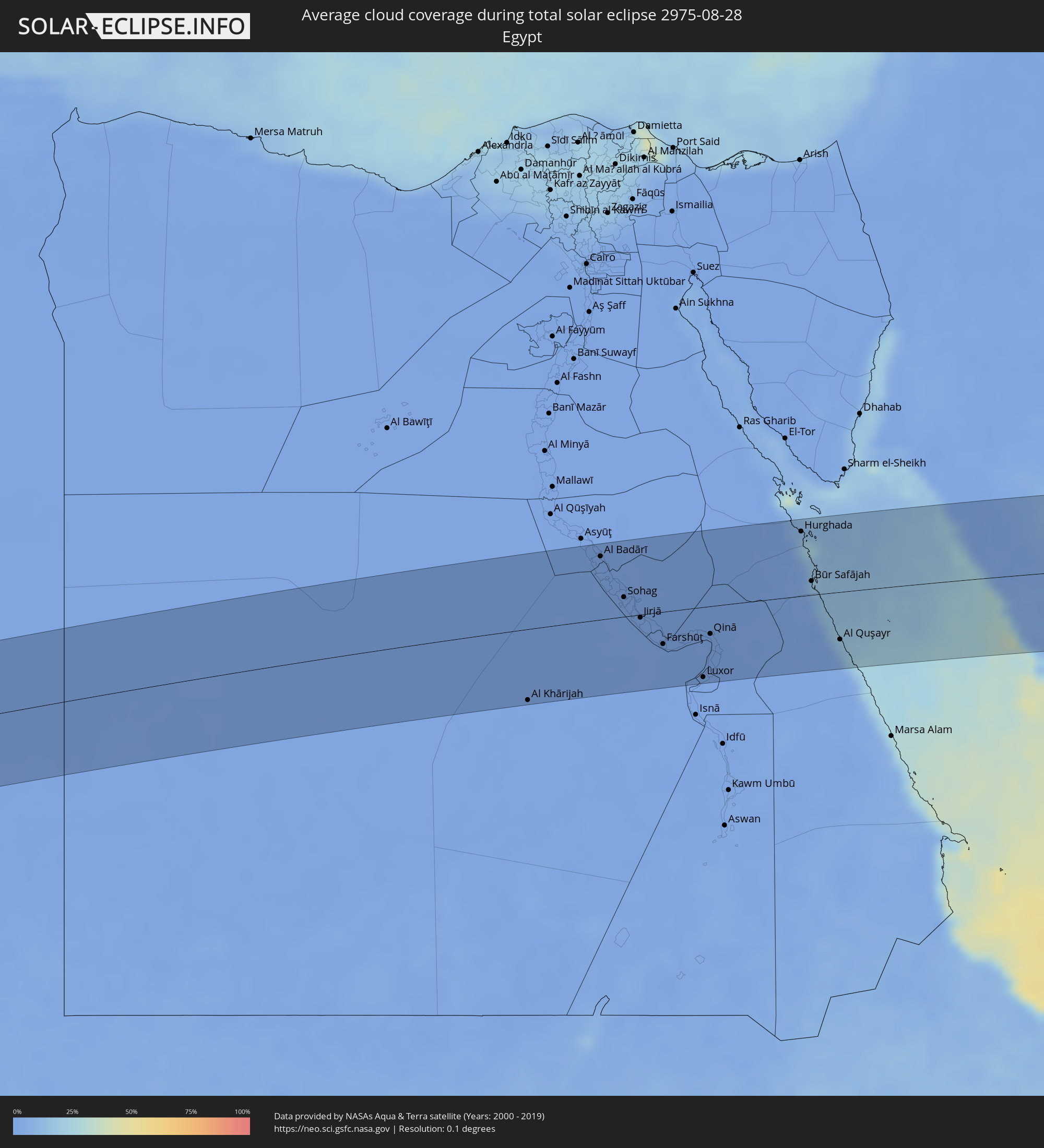 Ägypten
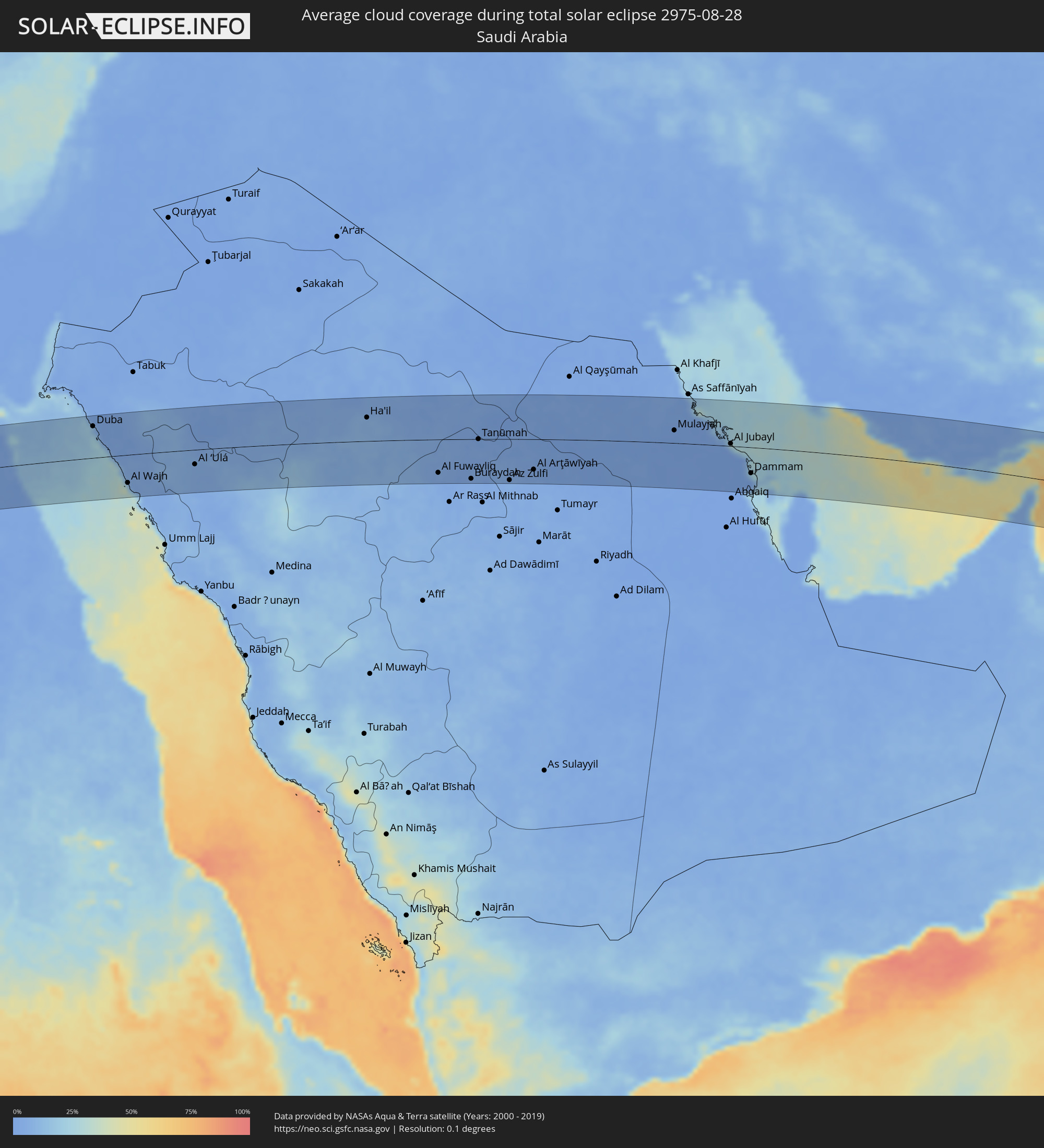 Saudi-Arabien
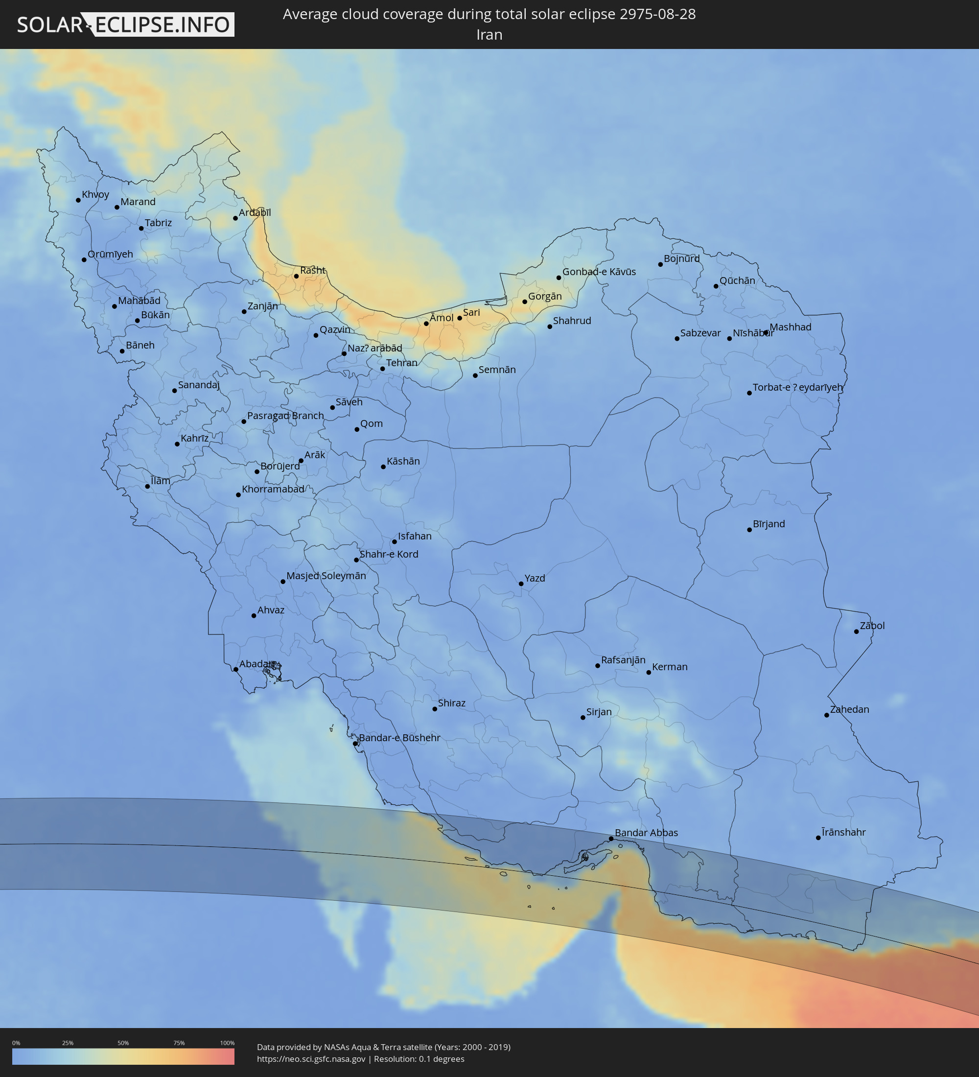 Iran
Iran
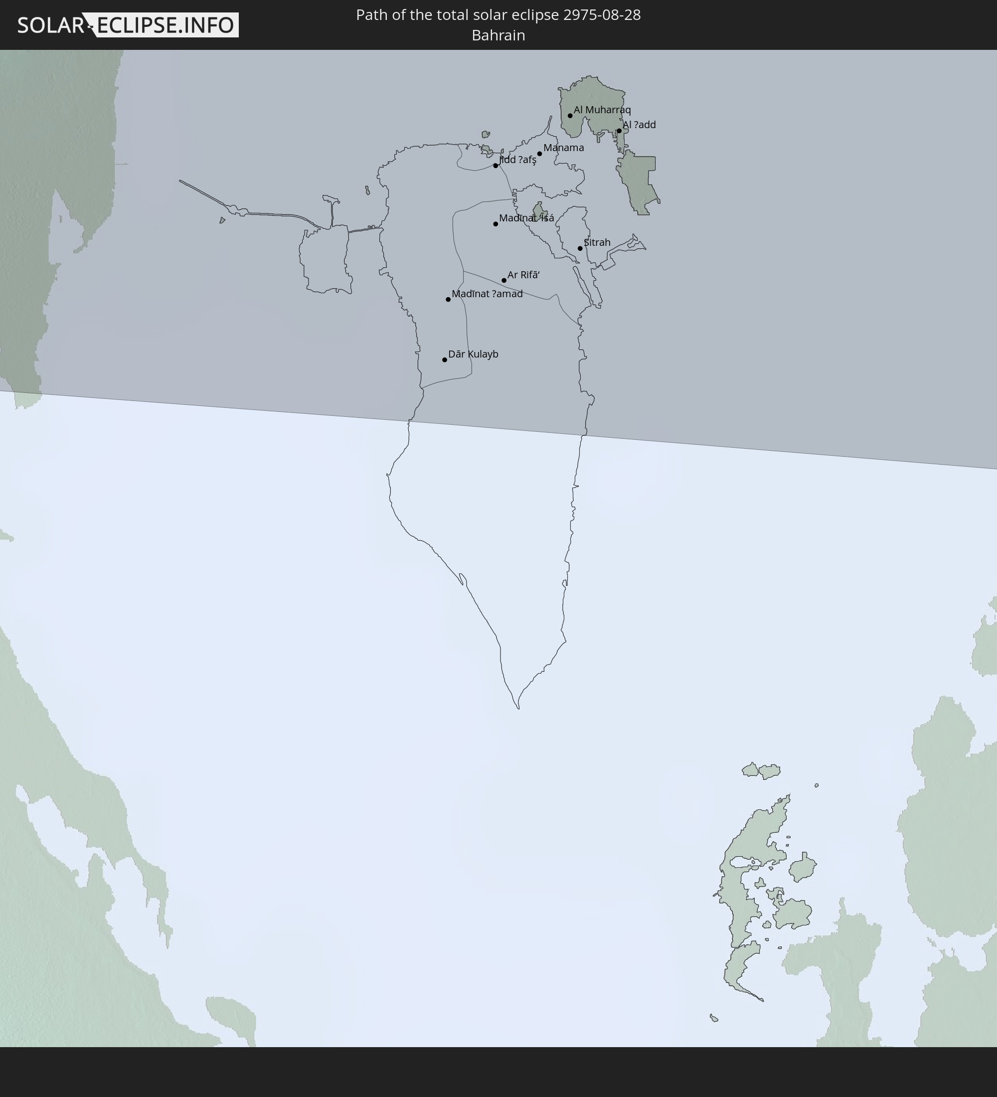
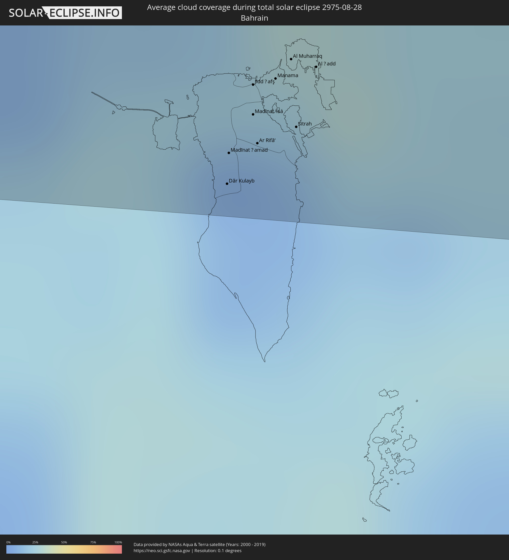 Bahrain
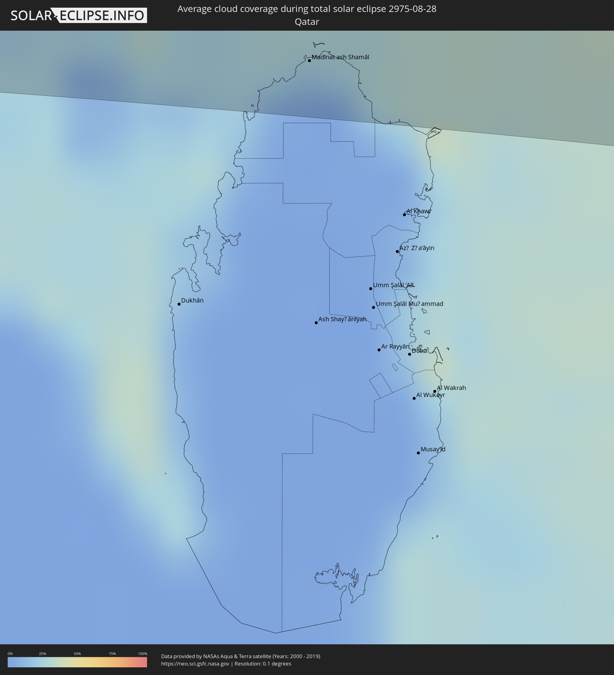 Katar
Katar
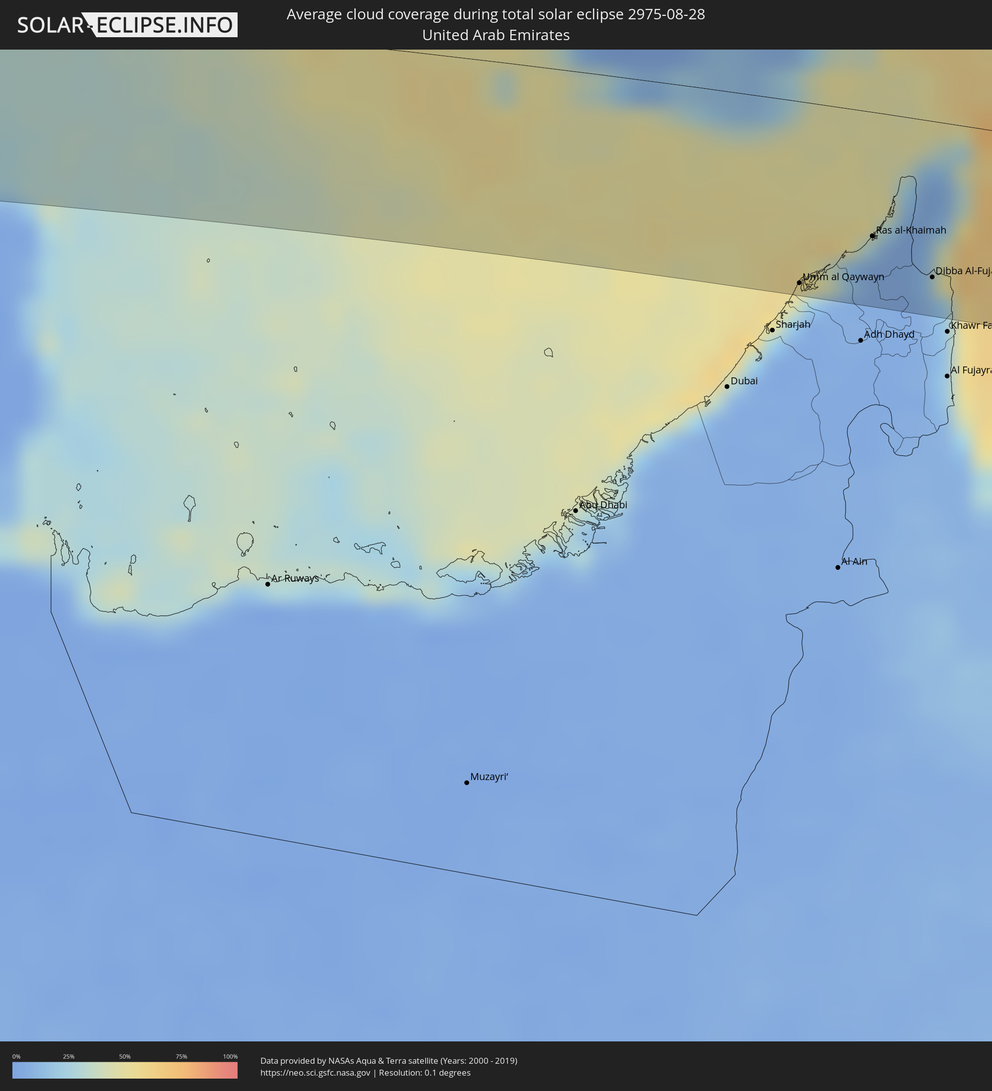 Vereinigte Arabische Emirate
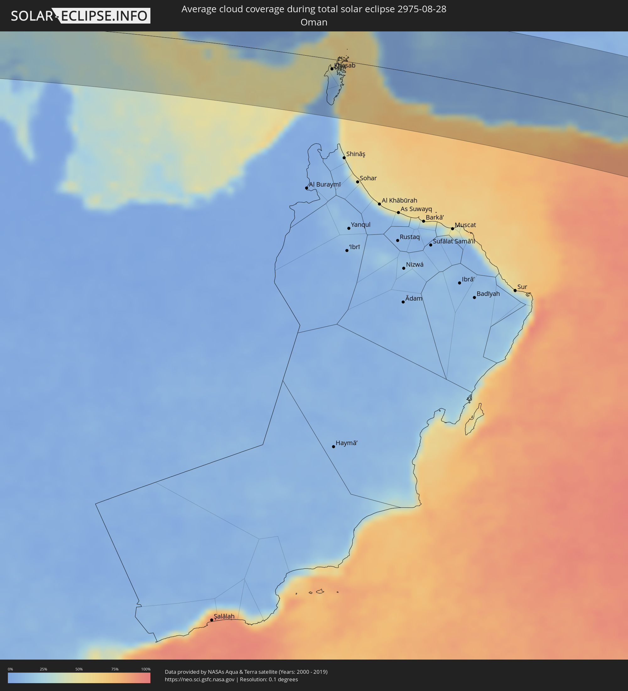 Oman
Oman
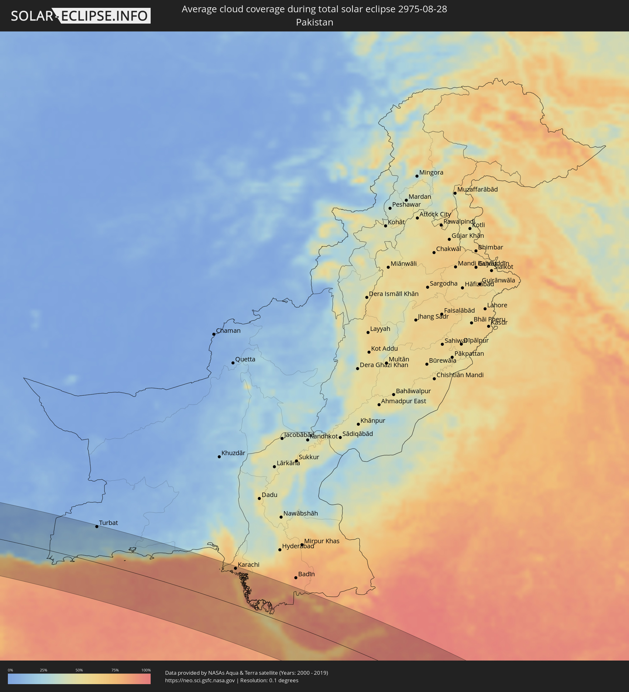 Pakistan
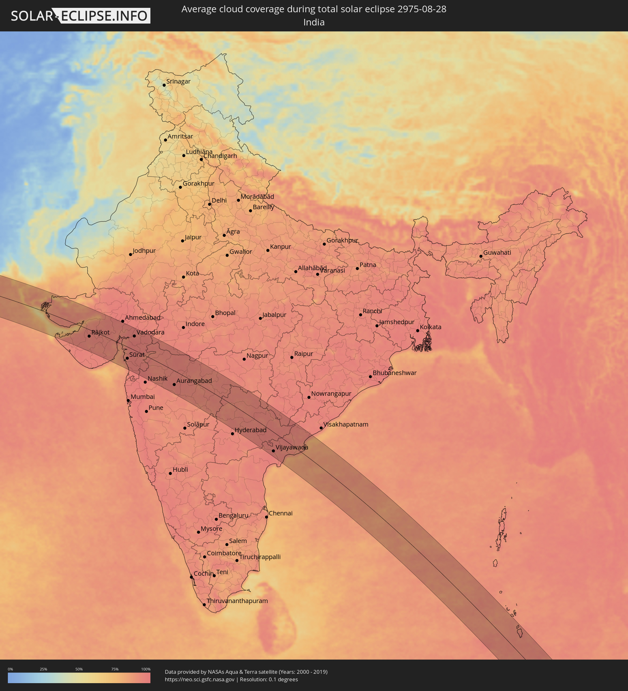 Indien
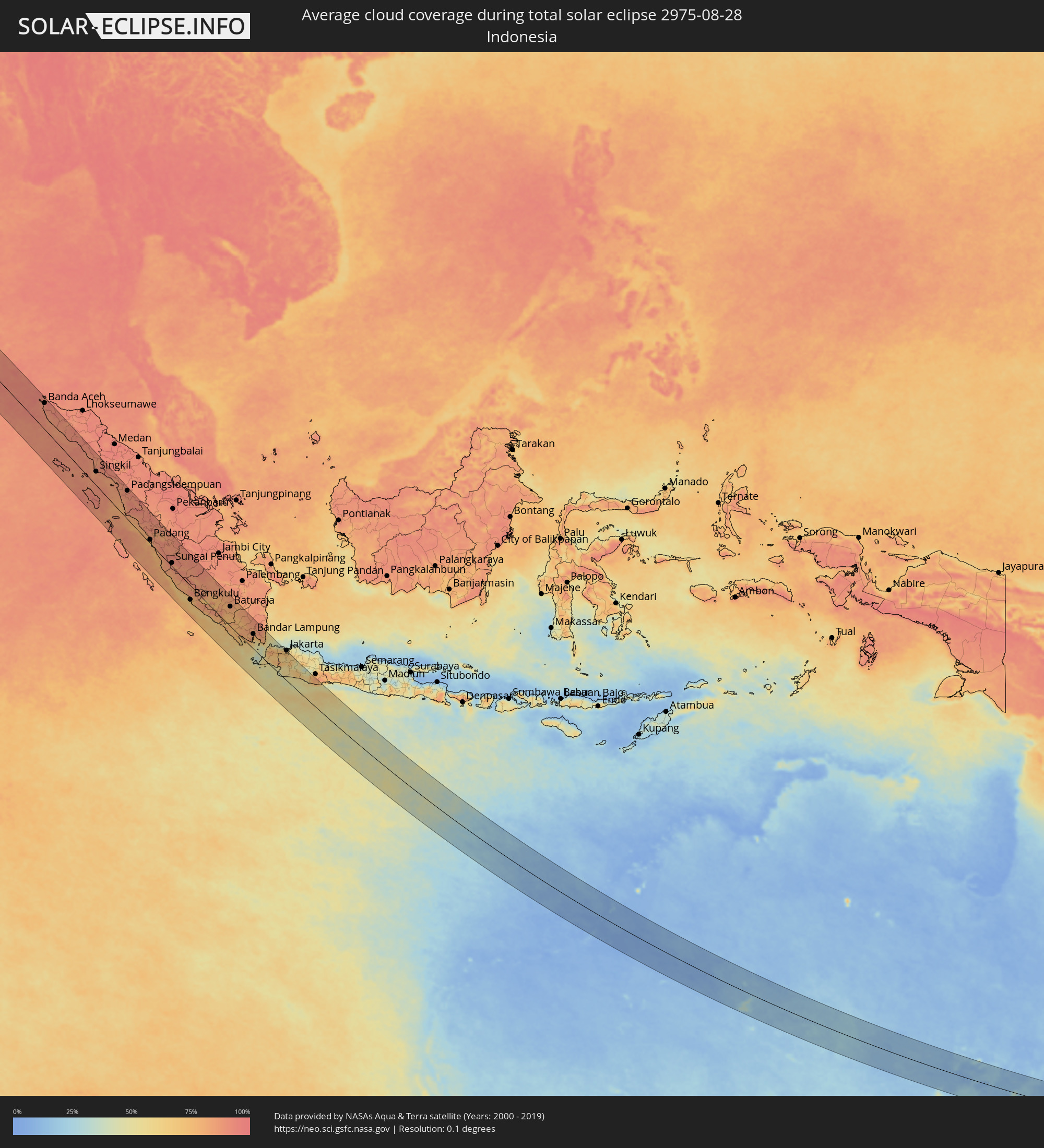 Indonesien
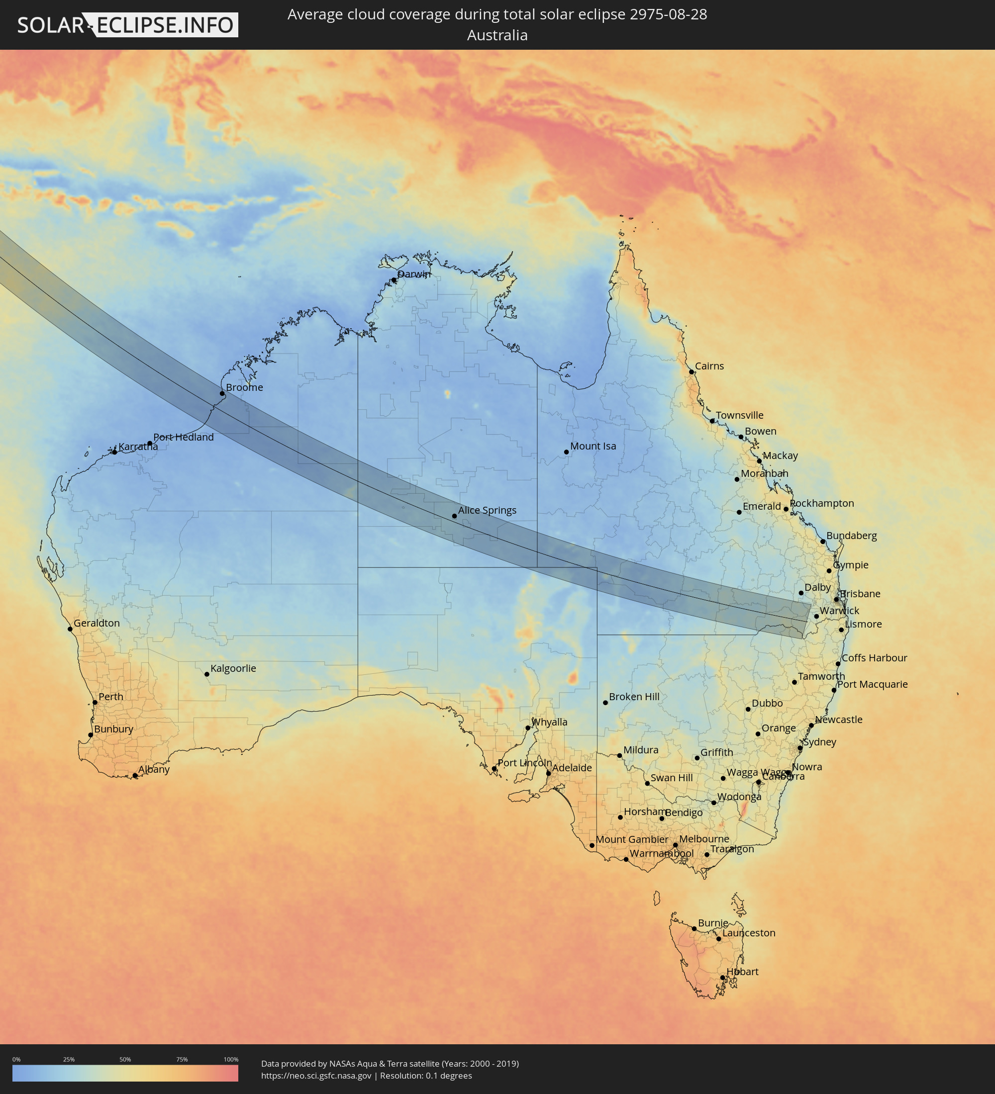 Australien
Orte im Finsternispfad
Die nachfolgene Tabelle zeigt Städte und Orte mit mehr als 5.000 Einwohnern, die sich im Finsternispfad befinden. Städte mit mehr als 100.000 Einwohnern sind dick gekennzeichnet. Mit einem Klick auf den Ort öffnet sich eine Detailkarte die die Lage des jeweiligen Ortes zusammen mit dem Verlauf der zentralen Finsternis präsentiert.
| Ort | Typ | Dauer der Verfinsterung | Ortszeit bei maximaler Verfinsterung | Entfernung zur Zentrallinie | Ø Bewölkung |
|
Al Khārijah, New Valley
|
total | - | 06:10:08 UTC+02:00 | 84 km | 0% |
|
Abū Tīj, Asyut
|
total | - | 06:10:24 UTC+02:00 | 82 km | 0% |
|
Al Badārī, Asyut
|
total | - | 06:10:25 UTC+02:00 | 75 km | 1% |
|
Juhaynah, Sohag
|
total | - | 06:10:24 UTC+02:00 | 38 km | 0% |
|
Ţahţā, Sohag
|
total | - | 06:10:25 UTC+02:00 | 49 km | 1% |
|
Sohag, Sohag
|
total | - | 06:10:26 UTC+02:00 | 23 km | 1% |
|
Akhmīm, Sohag
|
total | - | 06:10:27 UTC+02:00 | 23 km | 1% |
|
Al Manshāh, Sohag
|
total | - | 06:10:27 UTC+02:00 | 13 km | 1% |
|
Jirjā, Sohag
|
total | - | 06:10:28 UTC+02:00 | 4 km | 1% |
|
Al Balyanā, Sohag
|
total | - | 06:10:29 UTC+02:00 | 16 km | 1% |
|
Farshūţ, Qena
|
total | - | 06:10:30 UTC+02:00 | 38 km | 1% |
|
Naj‘ Ḩammādī, Qena
|
total | - | 06:10:31 UTC+02:00 | 40 km | 0% |
|
Dishnā, Qena
|
total | - | 06:10:35 UTC+02:00 | 34 km | 0% |
|
Luxor, Luxor
|
total | - | 06:10:36 UTC+02:00 | 83 km | 0% |
|
Qinā, Qena
|
total | - | 06:10:38 UTC+02:00 | 33 km | 1% |
|
Kousa, Qena
|
total | - | 06:10:38 UTC+02:00 | 61 km | 0% |
|
Hurghada, Red Sea
|
total | - | 06:11:00 UTC+02:00 | 76 km | 9% |
|
Būr Safājah, Red Sea
|
total | - | 06:11:00 UTC+02:00 | 16 km | 6% |
|
Al Quşayr, Red Sea
|
total | - | 06:11:03 UTC+02:00 | 56 km | 11% |
|
Duba, Tabuk
|
total | - | 07:11:34 UTC+03:00 | 68 km | 12% |
|
Al Wajh, Tabuk
|
total | - | 07:11:47 UTC+03:00 | 61 km | 20% |
|
Al ‘Ulá, Al Madīnah al Munawwarah
|
total | - | 07:12:22 UTC+03:00 | 32 km | 5% |
|
Ha'il, Ḩāʼil
|
total | - | 07:14:10 UTC+03:00 | 51 km | 8% |
|
Buraydah, Al-Qassim
|
total | - | 07:15:31 UTC+03:00 | 86 km | 4% |
|
Tanūmah, Al-Qassim
|
total | - | 07:15:35 UTC+03:00 | 0 km | 2% |
|
Az Zulfi, Ar Riyāḑ
|
total | - | 07:16:04 UTC+03:00 | 89 km | 5% |
|
Al Arţāwīyah, Ar Riyāḑ
|
total | - | 07:16:24 UTC+03:00 | 66 km | 3% |
|
Al Jubayl, Eastern Province
|
total | - | 07:19:36 UTC+03:00 | 5 km | 13% |
|
Umm as Sāhik, Eastern Province
|
total | - | 07:19:52 UTC+03:00 | 33 km | 1% |
|
Al Awjām, Eastern Province
|
total | - | 07:19:55 UTC+03:00 | 43 km | 1% |
|
Şafwá, Eastern Province
|
total | - | 07:19:54 UTC+03:00 | 33 km | 6% |
|
Al Qaţīf, Eastern Province
|
total | - | 07:19:59 UTC+03:00 | 47 km | 2% |
|
Tārūt, Eastern Province
|
total | - | 07:19:59 UTC+03:00 | 41 km | 6% |
|
Sayhāt, Eastern Province
|
total | - | 07:20:00 UTC+03:00 | 51 km | 2% |
|
Raḩīmah, Eastern Province
|
total | - | 07:19:59 UTC+03:00 | 26 km | 25% |
|
Dammam, Eastern Province
|
total | - | 07:20:04 UTC+03:00 | 56 km | 1% |
|
Dhahran, Eastern Province
|
total | - | 07:20:06 UTC+03:00 | 72 km | 2% |
|
Khobar, Eastern Province
|
total | - | 07:20:11 UTC+03:00 | 73 km | 11% |
|
Dār Kulayb, Southern Governorate
|
total | - | 07:20:29 UTC+03:00 | 94 km | 11% |
|
Madīnat Ḩamad, Central Governorate
|
total | - | 07:20:29 UTC+03:00 | 89 km | 11% |
|
Jidd Ḩafş, Manama
|
total | - | 07:20:30 UTC+03:00 | 77 km | 8% |
|
Madīnat ‘Īsá, Southern Governorate
|
total | - | 07:20:30 UTC+03:00 | 82 km | 8% |
|
Ar Rifā‘, Southern Governorate
|
total | - | 07:20:31 UTC+03:00 | 87 km | 10% |
|
Manama, Manama
|
total | - | 07:20:32 UTC+03:00 | 76 km | 12% |
|
Al Muharraq, Muharraq
|
total | - | 07:20:33 UTC+03:00 | 72 km | 23% |
|
Sitrah, Manama
|
total | - | 07:20:34 UTC+03:00 | 84 km | 12% |
|
Al Ḩadd, Muharraq
|
total | - | 07:20:35 UTC+03:00 | 73 km | 23% |
|
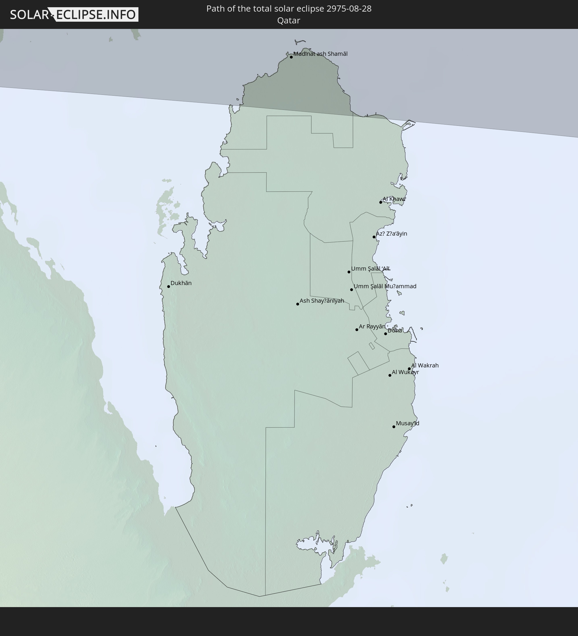
Madīnat ash Shamāl, Madīnat ash Shamāl
|
total | - | 07:21:06 UTC+03:00 | 82 km | 3% |
|
Kīsh, Hormozgan
|
total | - | 07:53:41 UTC+03:30 | 6 km | 37% |
|
Bandar-e Lengeh, Hormozgan
|
total | - | 07:54:33 UTC+03:30 | 5 km | 18% |
|
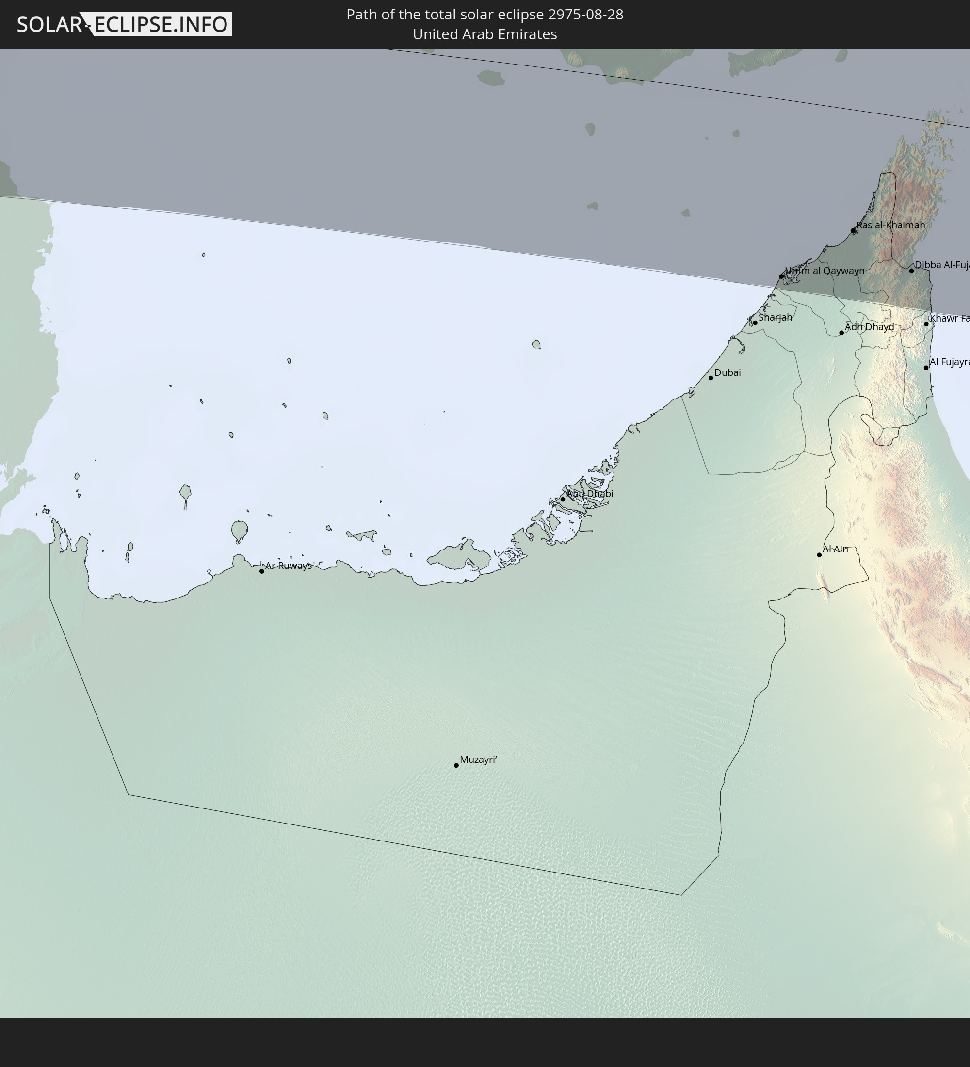
Umm al Qaywayn, Umm al Qaywayn
|
total | - | 08:25:35 UTC+04:00 | 96 km | 21% |
|
Ras al-Khaimah, Raʼs al Khaymah
|
total | - | 08:25:56 UTC+04:00 | 65 km | 29% |
|
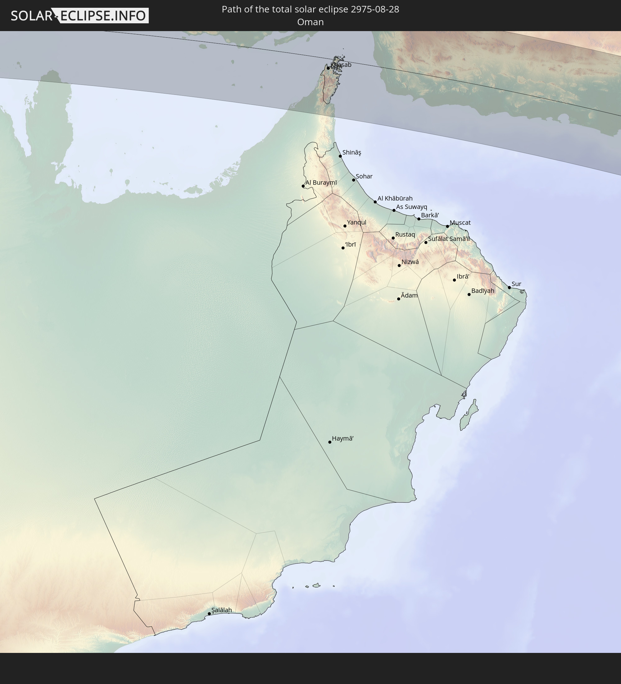
Khasab, Musandam
|
total | - | 08:26:07 UTC+04:00 | 18 km | 17% |
|
Dibba Al-Fujairah, Al Fujayrah
|
total | - | 08:26:21 UTC+04:00 | 82 km | 22% |
|
Qeshm, Hormozgan
|
total | - | 07:55:54 UTC+03:30 | 67 km | 50% |
|
Dibba Al-Hisn, Al Fujayrah
|
total | - | 08:26:21 UTC+04:00 | 79 km | 22% |
|
Bandar Abbas, Hormozgan
|
total | - | 07:55:50 UTC+03:30 | 94 km | 26% |
|
Mīnāb, Hormozgan
|
total | - | 07:56:44 UTC+03:30 | 100 km | 7% |
|
Chabahar, Sistan and Baluchestan
|
total | - | 08:01:42 UTC+03:30 | 33 km | 67% |
|
Qaşr-e Qand, Sistan and Baluchestan
|
total | - | 08:01:22 UTC+03:30 | 73 km | 8% |
|
Jīwani, Balochistān
|
total | - | 09:33:16 UTC+05:00 | 34 km | 80% |
|
Gwadar, Balochistān
|
total | - | 09:33:59 UTC+05:00 | 12 km | 80% |
|
Turbat, Balochistān
|
total | - | 09:34:28 UTC+05:00 | 101 km | 16% |
|
Pasni, Balochistān
|
total | - | 09:35:27 UTC+05:00 | 32 km | 60% |
|
Ormāra, Balochistān
|
total | - | 09:37:06 UTC+05:00 | 59 km | 75% |
|
Karachi, Sindh
|
total | - | 09:40:52 UTC+05:00 | 101 km | 82% |
|
Ghāro, Sindh
|
total | - | 09:41:44 UTC+05:00 | 101 km | 83% |
|
Mīrpur Sakro, Sindh
|
total | - | 09:41:57 UTC+05:00 | 82 km | 86% |
|
Chuhar Jamāli, Sindh
|
total | - | 09:42:38 UTC+05:00 | 78 km | 89% |
|
Jāti, Sindh
|
total | - | 09:43:05 UTC+05:00 | 83 km | 85% |
|
Jāmnagar, Gujarat
|
total | - | 10:17:37 UTC+05:30 | 45 km | 93% |
|
Rājkot, Gujarat
|
total | - | 10:19:00 UTC+05:30 | 34 km | 93% |
|
Bhāvnagar, Gujarat
|
total | - | 10:21:51 UTC+05:30 | 30 km | 92% |
|
Sūrat, Gujarat
|
total | - | 10:23:39 UTC+05:30 | 58 km | 92% |
|
Bilimora, Gujarat
|
total | - | 10:24:22 UTC+05:30 | 95 km | 95% |
|
Vadodara, Gujarat
|
total | - | 10:23:06 UTC+05:30 | 69 km | 96% |
|
Mālegaon, Maharashtra
|
total | - | 10:27:27 UTC+05:30 | 43 km | 92% |
|
Dhūlia, Maharashtra
|
total | - | 10:27:28 UTC+05:30 | 4 km | 92% |
|
Aurangabad, Maharashtra
|
total | - | 10:29:46 UTC+05:30 | 69 km | 95% |
|
Jalgaon, Maharashtra
|
total | - | 10:28:46 UTC+05:30 | 52 km | 95% |
|
Parbhani, Maharashtra
|
total | - | 10:33:13 UTC+05:30 | 54 km | 93% |
|
Akola, Maharashtra
|
total | - | 10:31:44 UTC+05:30 | 97 km | 93% |
|
Nanded, Maharashtra
|
total | - | 10:34:24 UTC+05:30 | 35 km | 93% |
|
Nizāmābād, Telangana
|
total | - | 10:36:34 UTC+05:30 | 38 km | 93% |
|
Rāmgundam, Telangana
|
total | - | 10:38:58 UTC+05:30 | 51 km | 92% |
|
Warangal, Telangana
|
total | - | 10:40:24 UTC+05:30 | 16 km | 93% |
|
Vijayawada, Andhra Pradesh
|
total | - | 10:44:48 UTC+05:30 | 88 km | 96% |
|
Rājahmundry, Andhra Pradesh
|
total | - | 10:46:14 UTC+05:30 | 27 km | 93% |
|
Kākināda, Andhra Pradesh
|
total | - | 10:47:12 UTC+05:30 | 52 km | 91% |
|
Banda Aceh, Aceh
|
total | - | 13:04:47 UTC+07:00 | 95 km | 90% |
|
Padang, West Sumatra
|
total | - | 13:26:49 UTC+07:00 | 14 km | 83% |
|
Payakumbuh, West Sumatra
|
total | - | 13:25:53 UTC+07:00 | 93 km | 88% |
|
Bengkulu, Bengkulu
|
total | - | 13:35:22 UTC+07:00 | 51 km | 74% |
|
Lubuklinggau, South Sumatra
|
total | - | 13:35:25 UTC+07:00 | 35 km | 84% |
|
Baturaja, South Sumatra
|
total | - | 13:39:01 UTC+07:00 | 74 km | 82% |
|
Bandar Lampung, Lampung
|
total | - | 13:43:01 UTC+07:00 | 56 km | 77% |
|
Metro, Lampung
|
total | - | 13:42:32 UTC+07:00 | 85 km | 85% |
|
Serang, Banten
|
total | - | 13:45:32 UTC+07:00 | 70 km | 77% |
|
Rangkasbitung, Banten
|
total | - | 13:46:06 UTC+07:00 | 58 km | 69% |
|
Tangerang, Banten
|
total | - | 13:46:22 UTC+07:00 | 102 km | 72% |
|
South Tangerang, Banten
|
total | - | 13:46:41 UTC+07:00 | 99 km | 72% |
|
Bogor, West Java
|
total | - | 13:47:17 UTC+07:00 | 80 km | 60% |
|
Depok, West Java
|
total | - | 13:47:01 UTC+07:00 | 98 km | 65% |
|
Sukabumi, West Java
|
total | - | 13:48:02 UTC+07:00 | 64 km | 59% |
|
Cileungsir, West Java
|
total | - | 13:47:13 UTC+07:00 | 109 km | 64% |
|
Padalarang, West Java
|
total | - | 13:48:42 UTC+07:00 | 112 km | 54% |
|
Banjaran, West Java
|
total | - | 13:49:12 UTC+07:00 | 104 km | 37% |
|
Paseh, West Java
|
total | - | 13:49:33 UTC+07:00 | 112 km | 49% |
|
Broome, Western Australia
|
total | - | 15:19:54 UTC+08:00 | 80 km | 8% |
|
Alice Springs, Northern Territory
|
total | - | 17:01:14 UTC+09:30 | 26 km | 23% |
|
Goondiwindi, Queensland
|
total | - | 17:36:07 UTC+10:00 | 36 km | 36% |