Total solar eclipse of 07/17/-0168
| Day of week: | Sunday |
| Maximum duration of eclipse: | 06m25s |
| Maximum width of eclipse path: | 236 km |
| Saros cycle: | 72 |
| Coverage: | 100% |
| Magnitude: | 1.0695 |
| Gamma: | -0.2917 |
Wo kann man die Sonnenfinsternis vom 07/17/-0168 sehen?
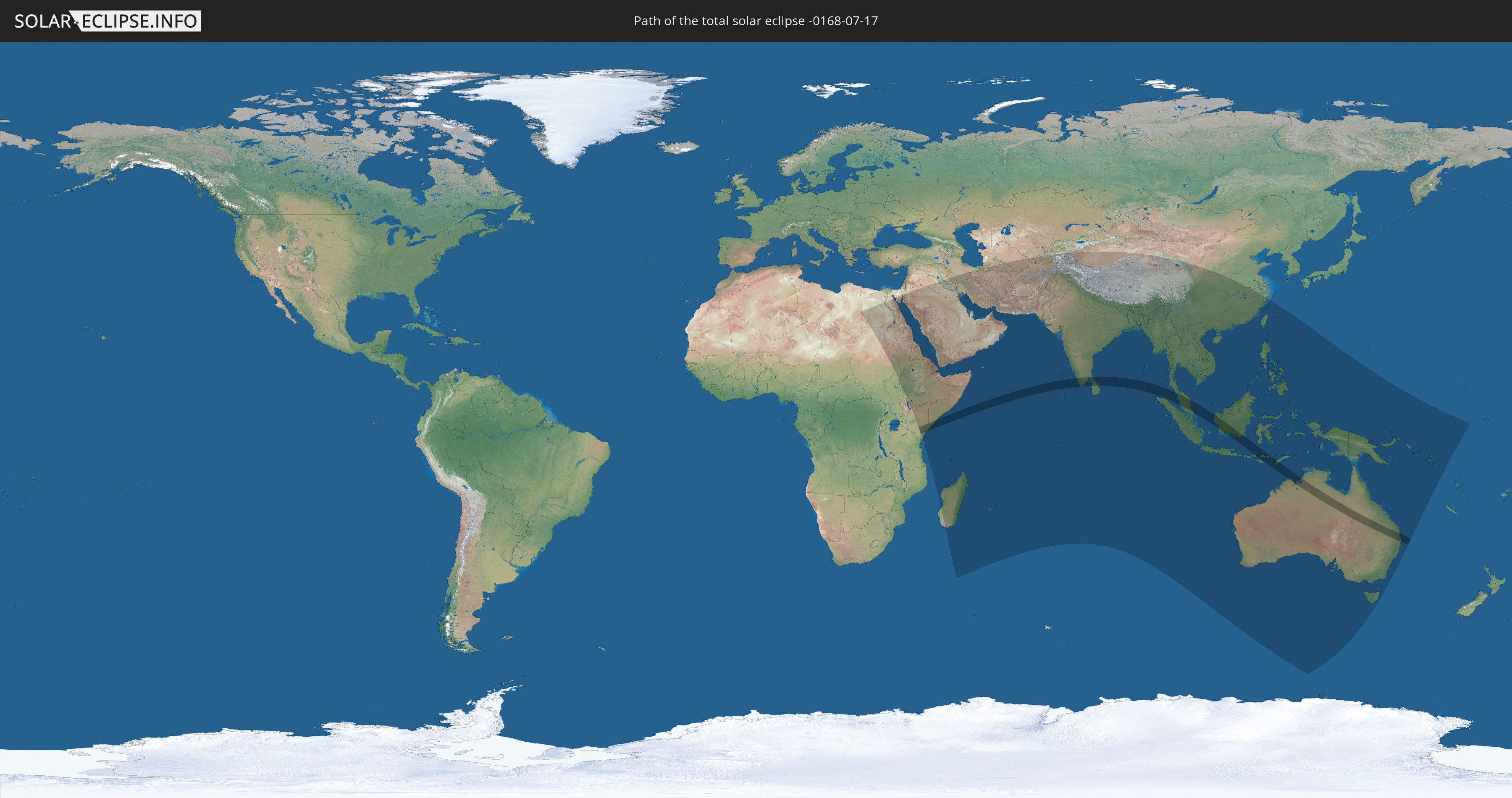
Die Sonnenfinsternis am 07/17/-0168 kann man in 66 Ländern als partielle Sonnenfinsternis beobachten.
Der Finsternispfad verläuft durch 8 Länder. Nur in diesen Ländern ist sie als total Sonnenfinsternis zu sehen.
In den folgenden Ländern ist die Sonnenfinsternis total zu sehen
 Kenya
Kenya
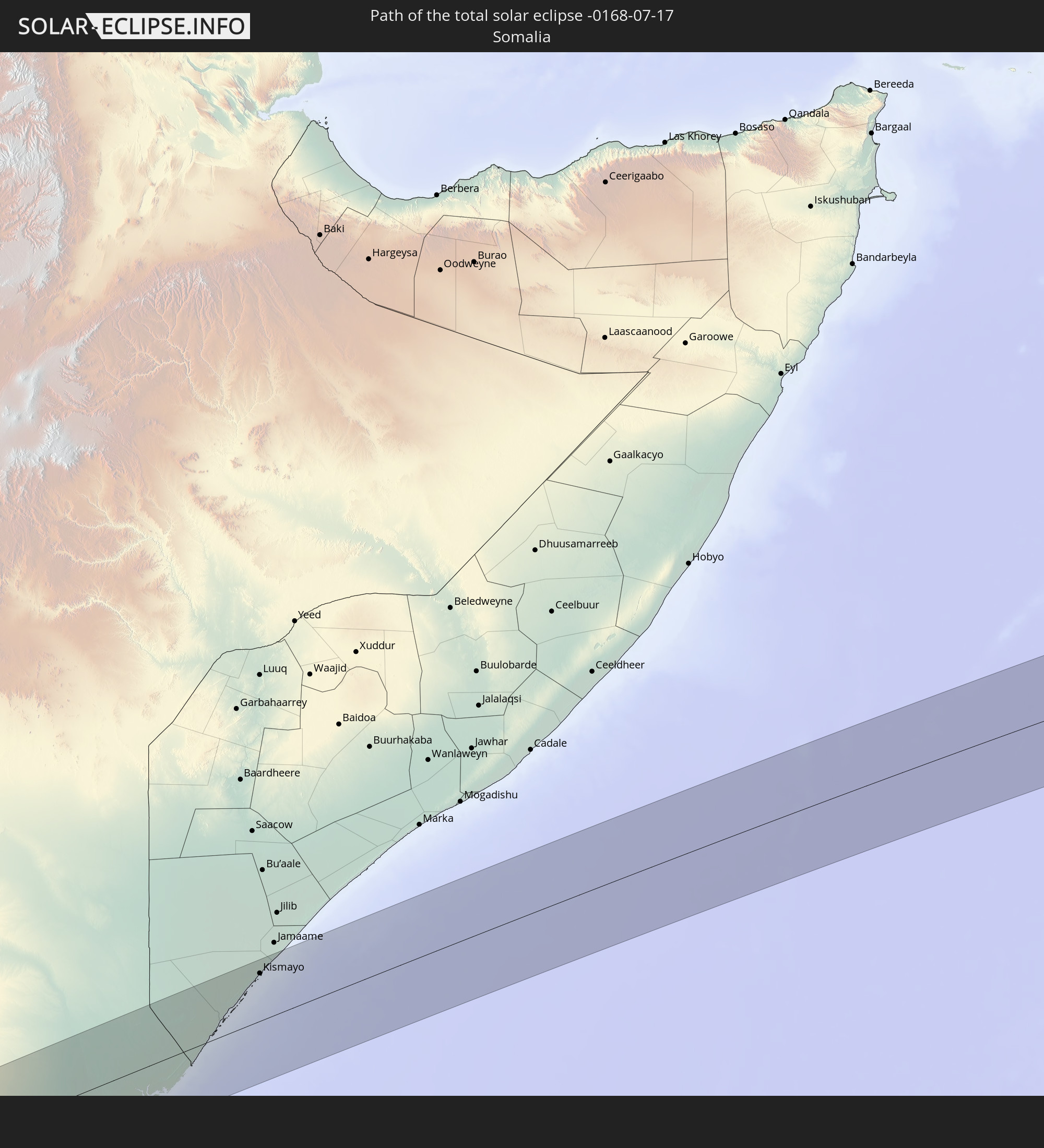 Somalia
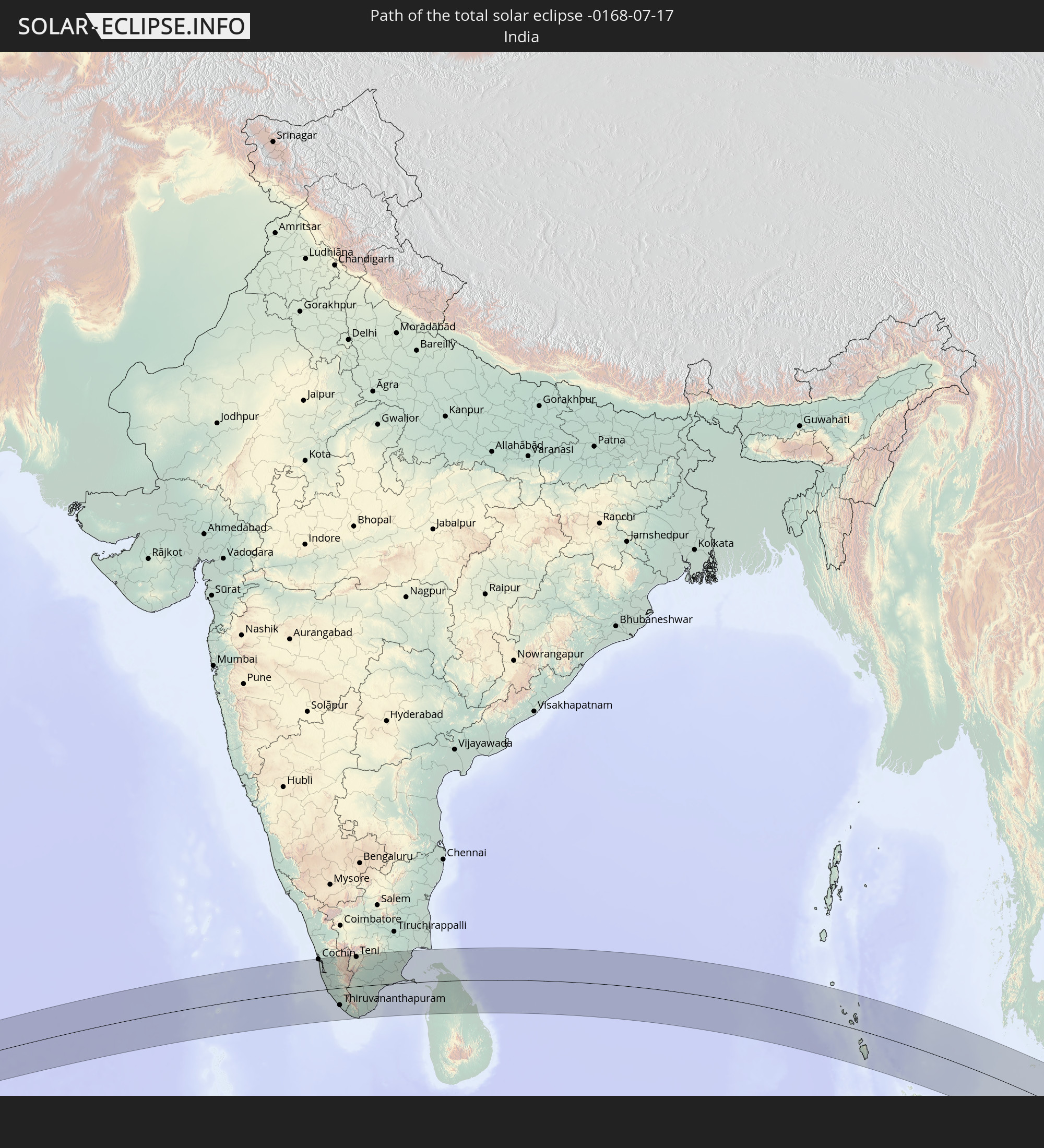 India
India
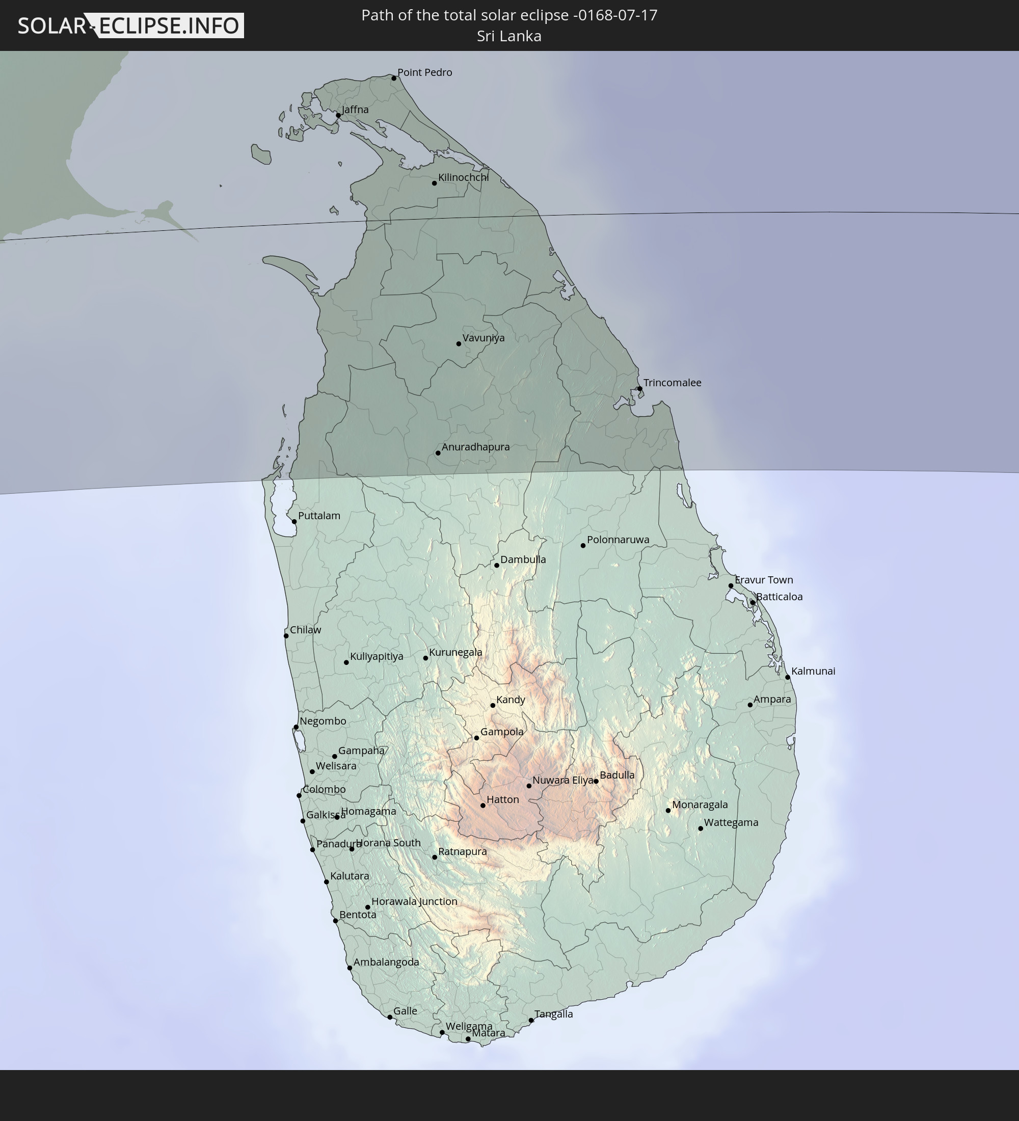 Sri Lanka
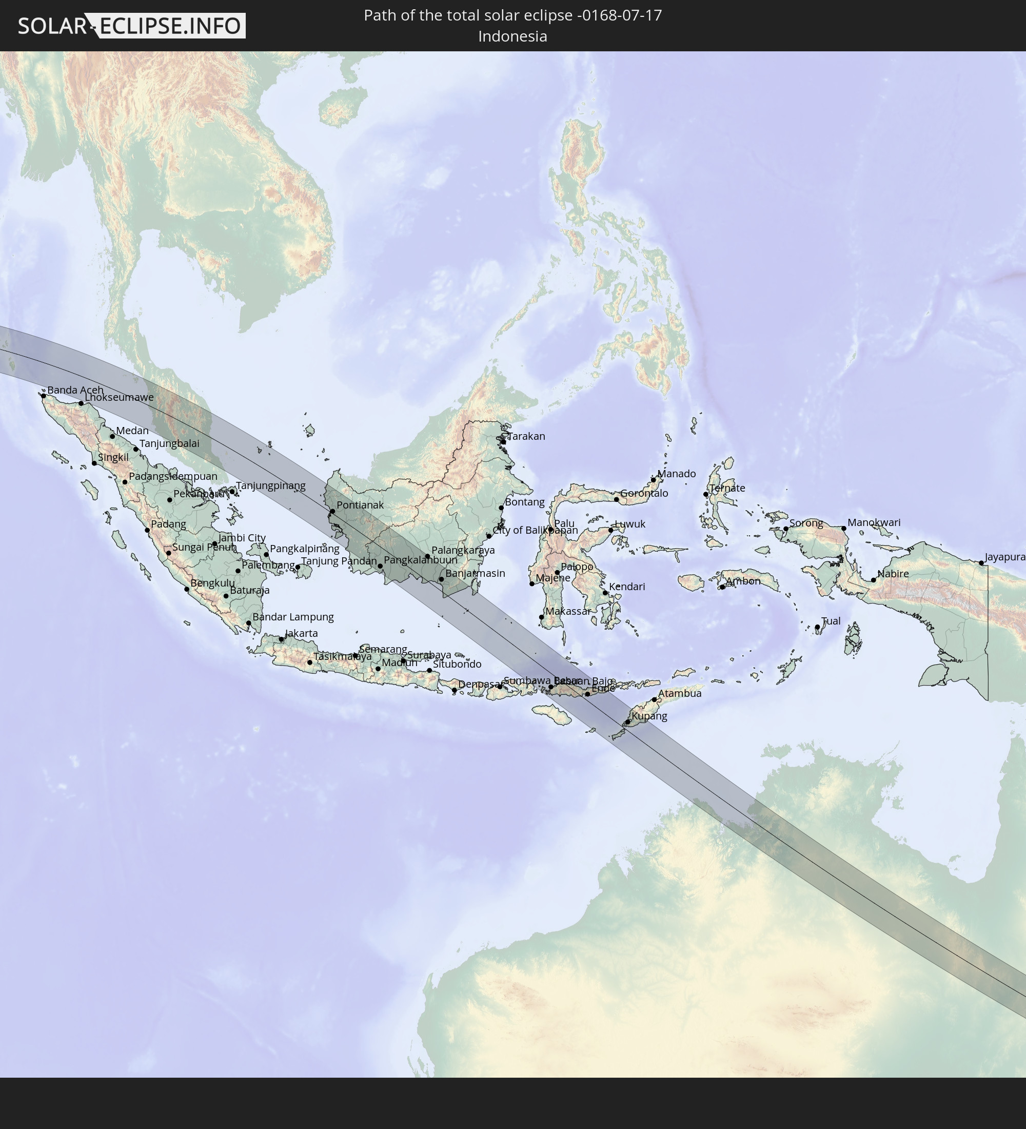 Indonesia
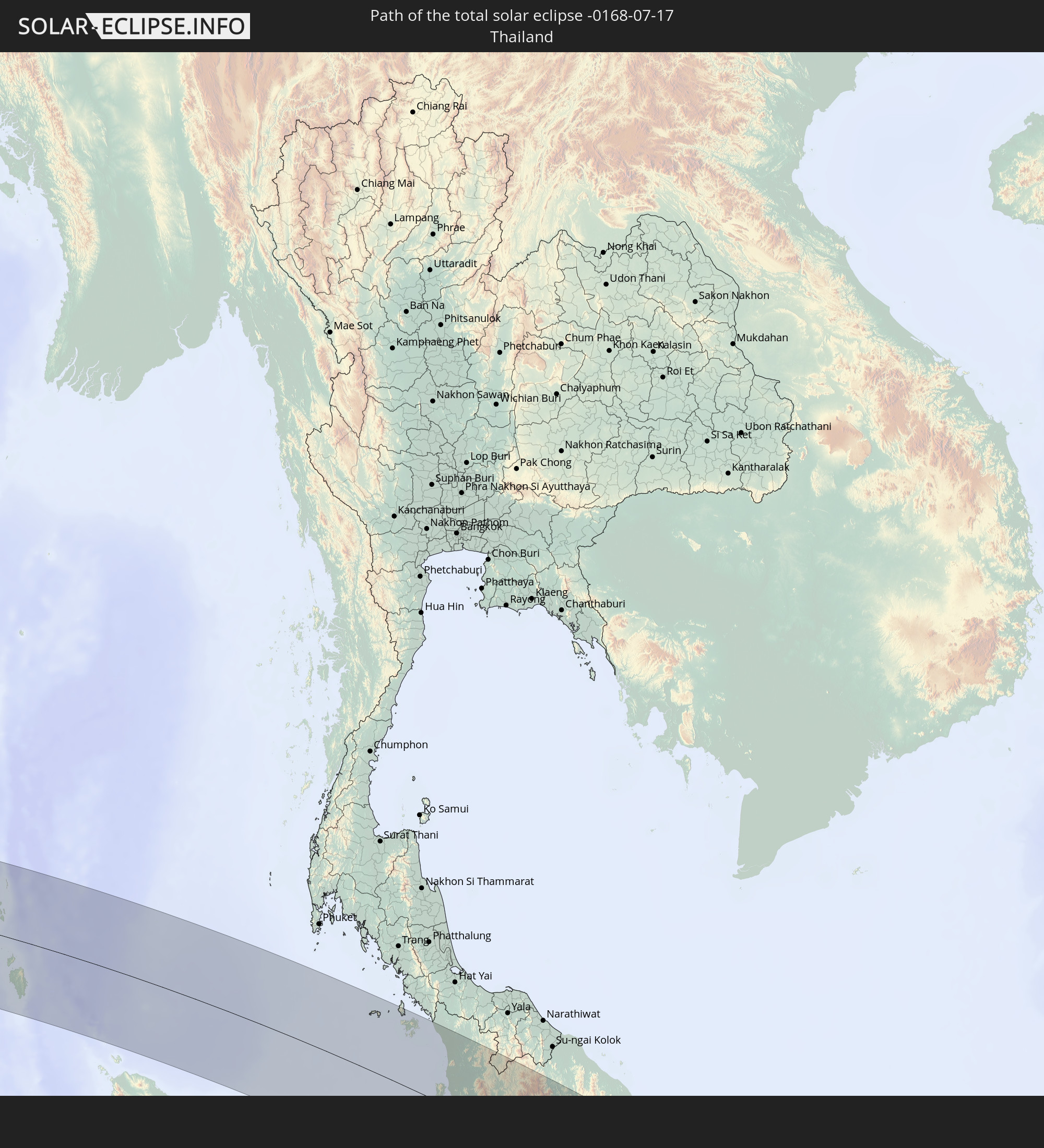 Thailand
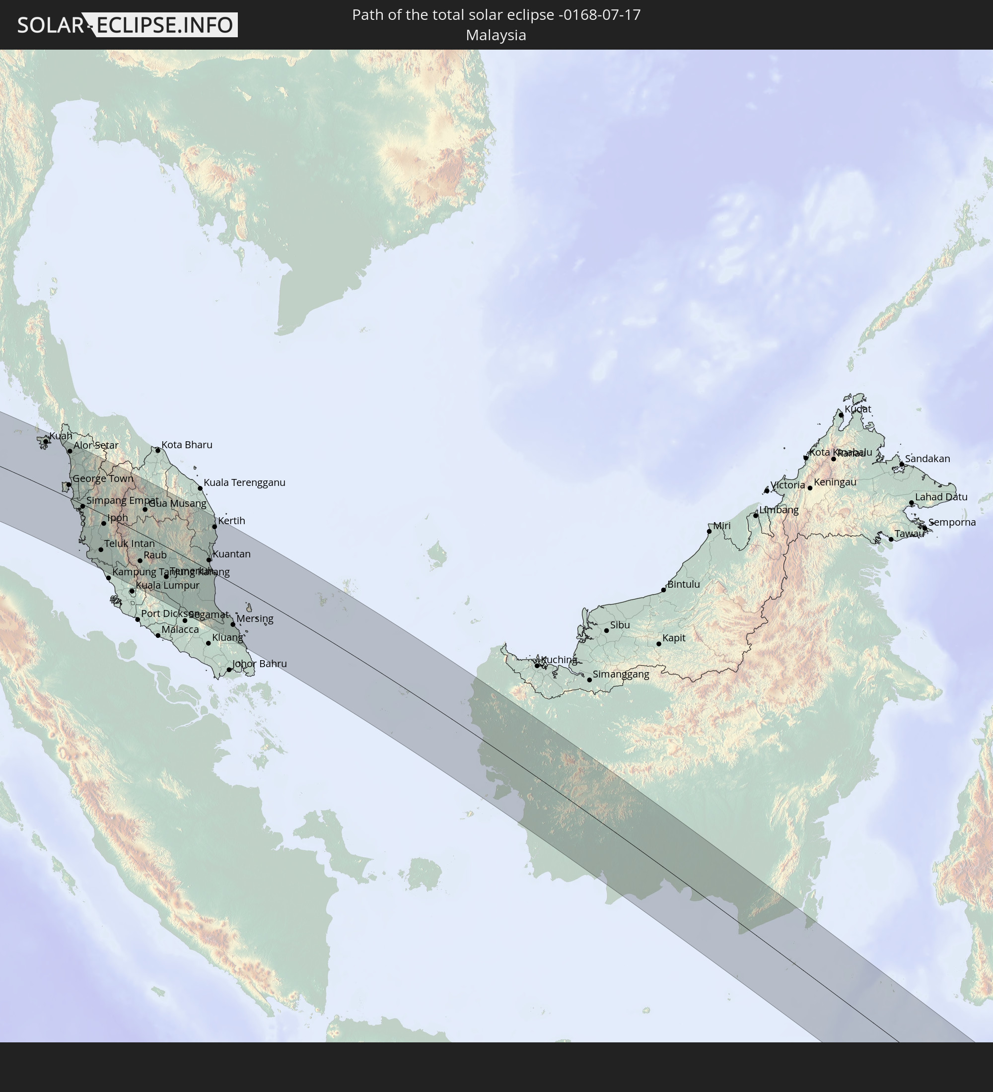 Malaysia
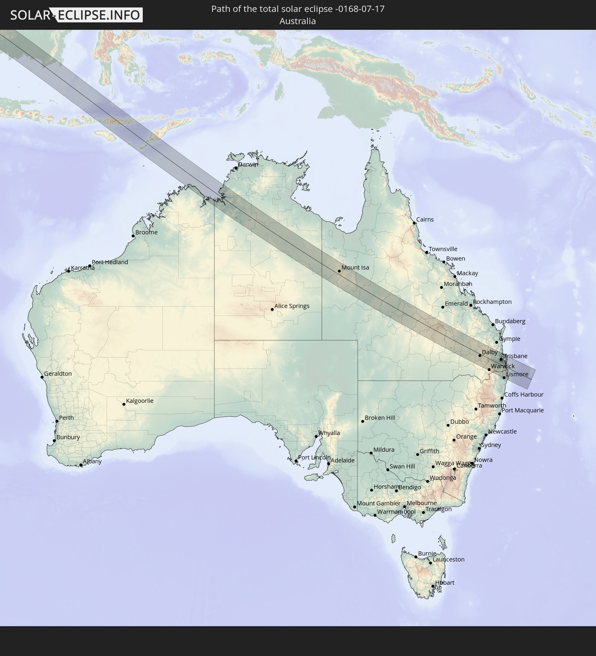 Australia
In den folgenden Ländern ist die Sonnenfinsternis partiell zu sehen
 Kiribati
 Libya
Libya
 Sudan
Sudan
 Egypt
Egypt
 Tanzania
 Ethiopia
 Kenya
Kenya
 Israel
 Saudi Arabia
 Jordan
 Eritrea
 Iraq
Iraq
 French Southern and Antarctic Lands
 Somalia
 Djibouti
 Yemen
Yemen
 Madagascar
 Comoros
 Iran
Iran
 Mayotte
 Seychelles
 Kuwait
 Bahrain
 Qatar
Qatar
 United Arab Emirates
 Oman
Oman
 Turkmenistan
 Réunion
 Uzbekistan
 Mauritius
 Afghanistan
 Pakistan
 Tajikistan
 India
India
 Kyrgyzstan
 British Indian Ocean Territory
 Maldives
 China
China
 Sri Lanka
 Nepal
Nepal
 Bangladesh
 Bhutan
 Myanmar
 Indonesia
 Cocos Islands
 Thailand
 Malaysia
 Laos
Laos
 Vietnam
 Cambodia
 Singapore
 Christmas Island
 Australia
 Macau
Macau
 Hong Kong
 Brunei
 Taiwan
 Philippines
 Japan
Japan
 East Timor
 Palau
Palau
 Federated States of Micronesia
 Papua New Guinea
 Solomon Islands
 New Caledonia
 Nauru
Nauru
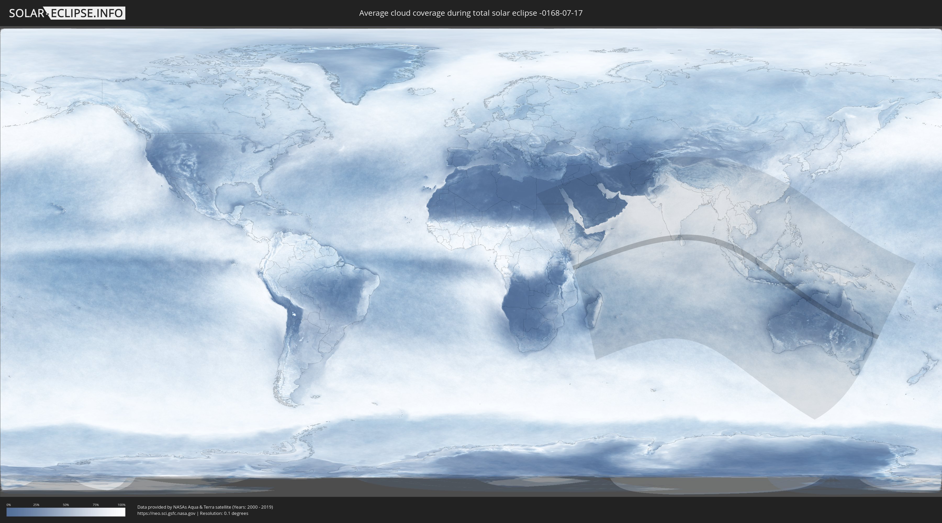
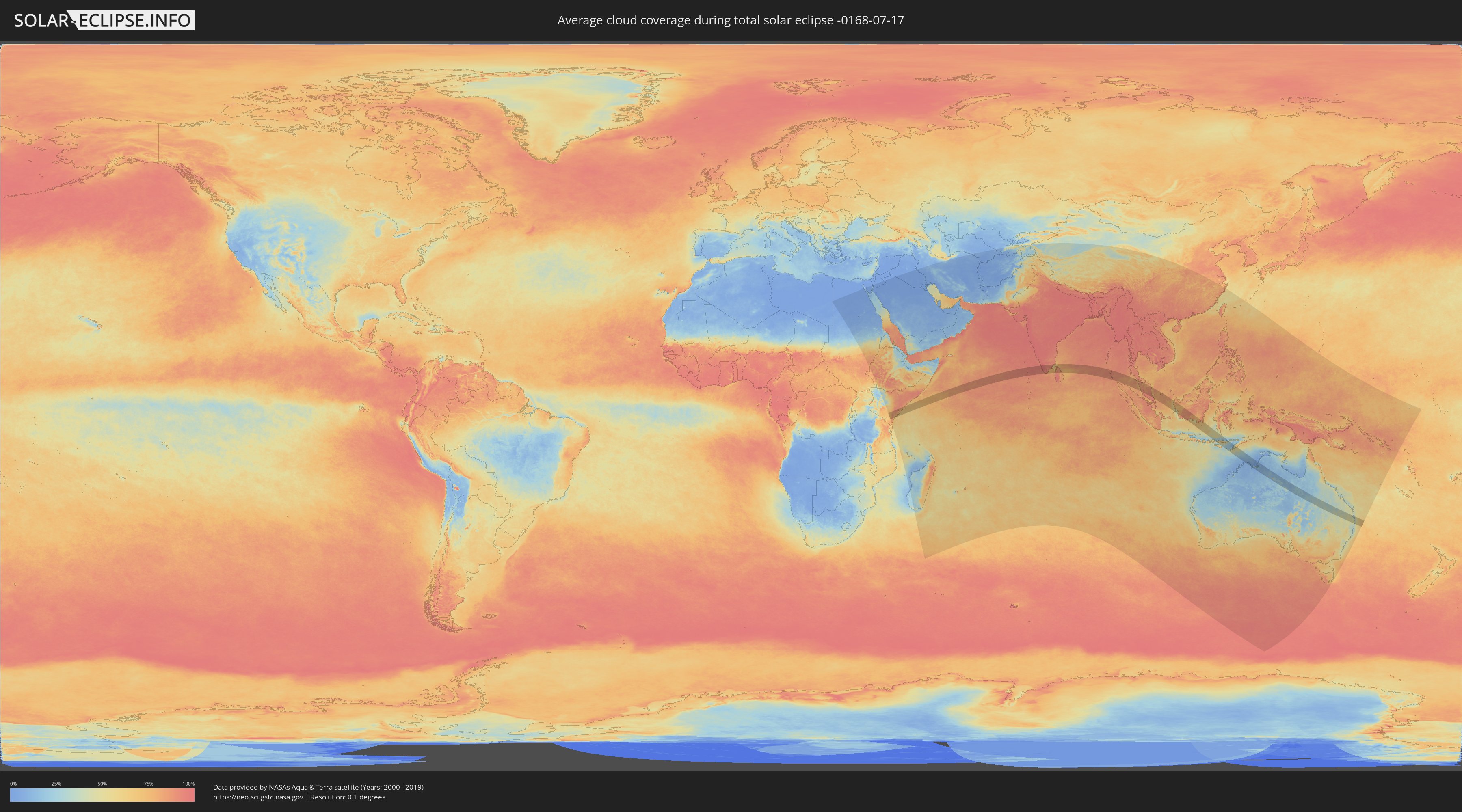
How will be the weather during the total solar eclipse on 07/17/-0168?
Where is the best place to see the total solar eclipse of 07/17/-0168?
The following maps show the average cloud coverage for the day of the total solar eclipse.
With the help of these maps, it is possible to find the place along the eclipse path, which has the best
chance of a cloudless sky.
Nevertheless, you should consider local circumstances and inform about the weather of your chosen
observation site.
The data is provided by NASAs satellites
AQUA and TERRA.
The cloud maps are averaged over a period of 19 years (2000 - 2019).
Detailed country maps
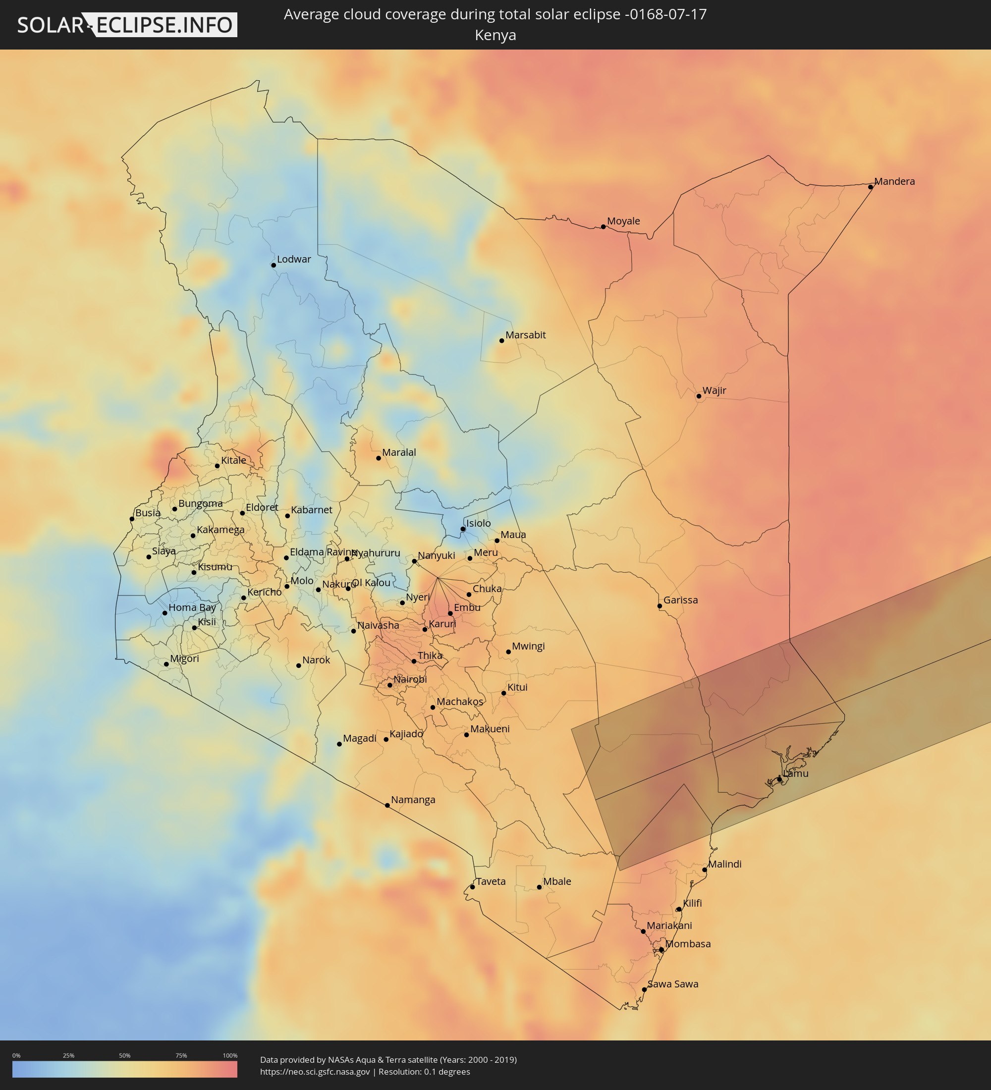 Kenya
Kenya
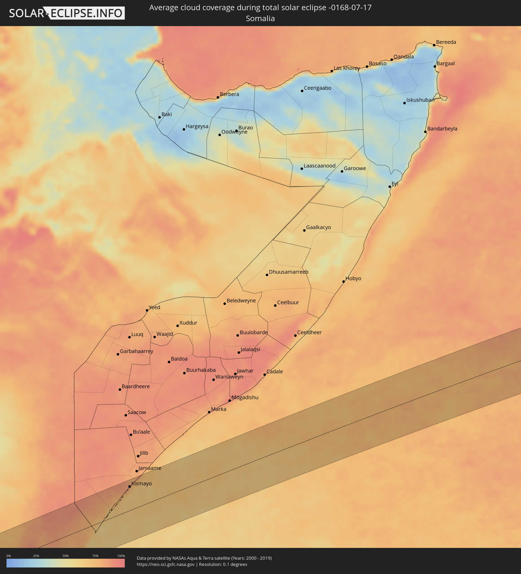 Somalia
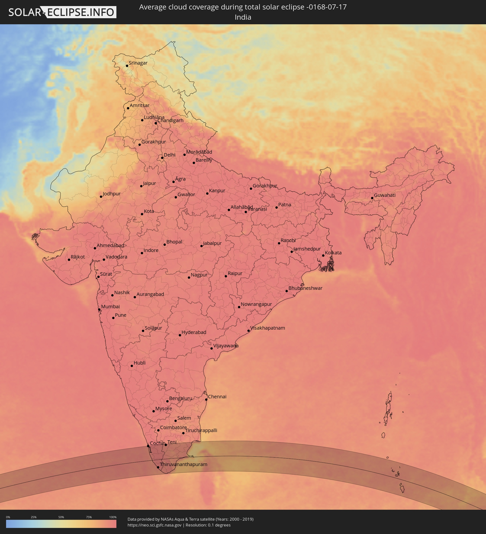 India
India
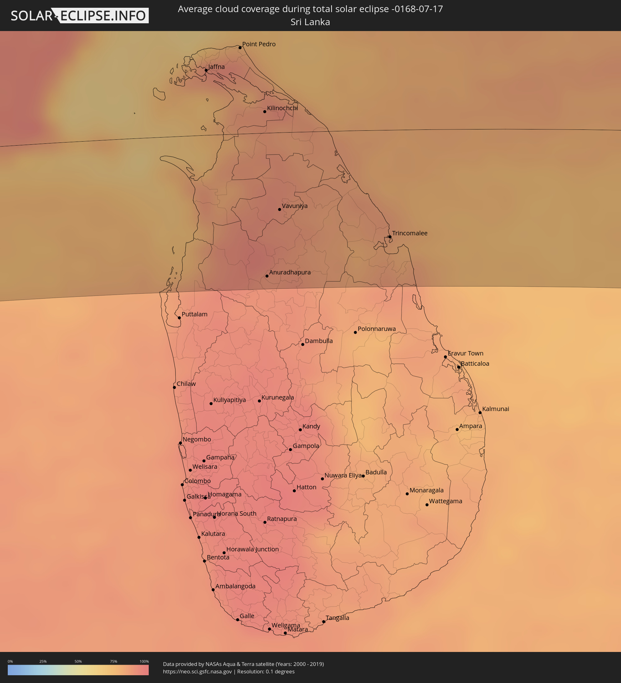 Sri Lanka
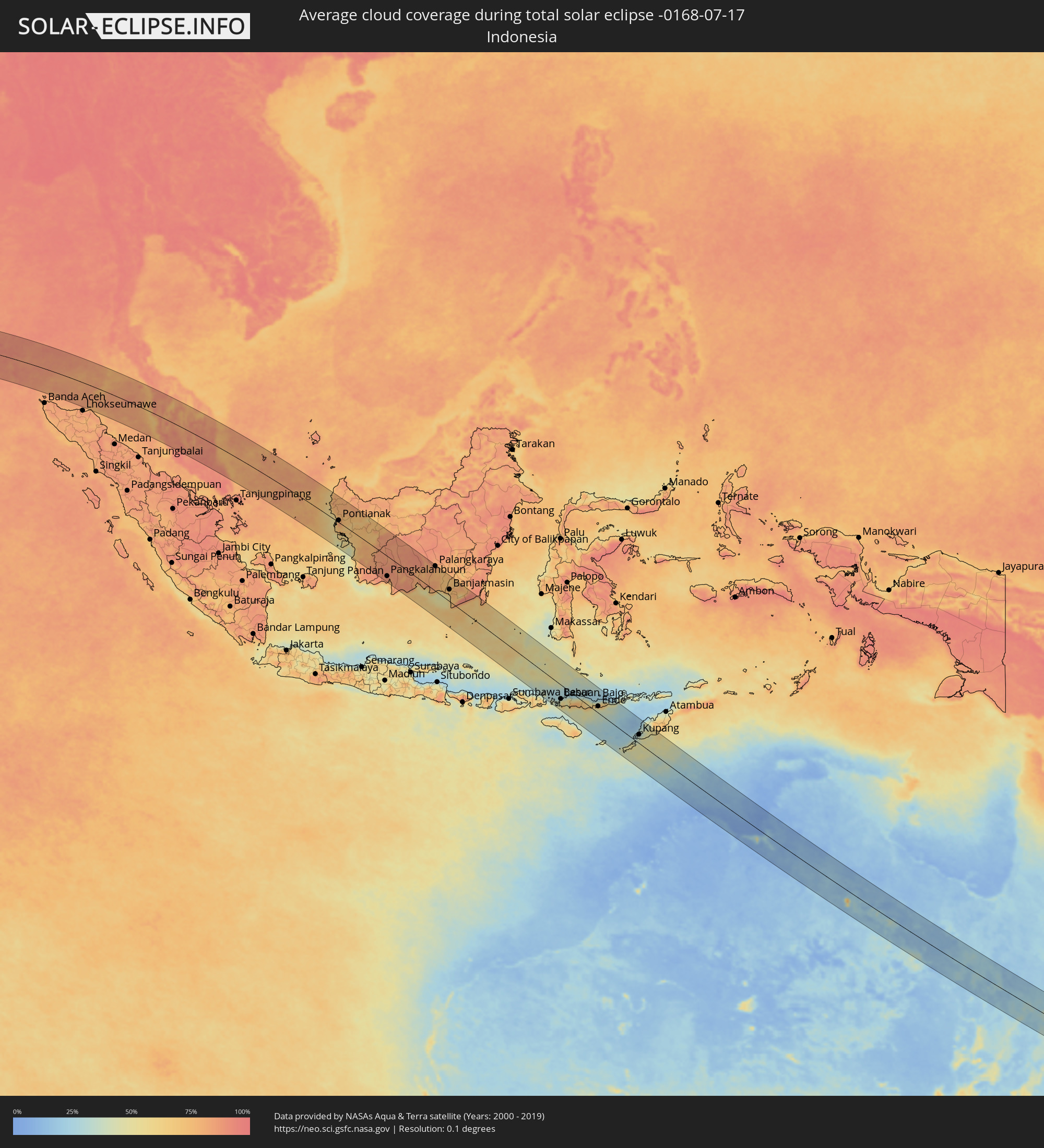 Indonesia
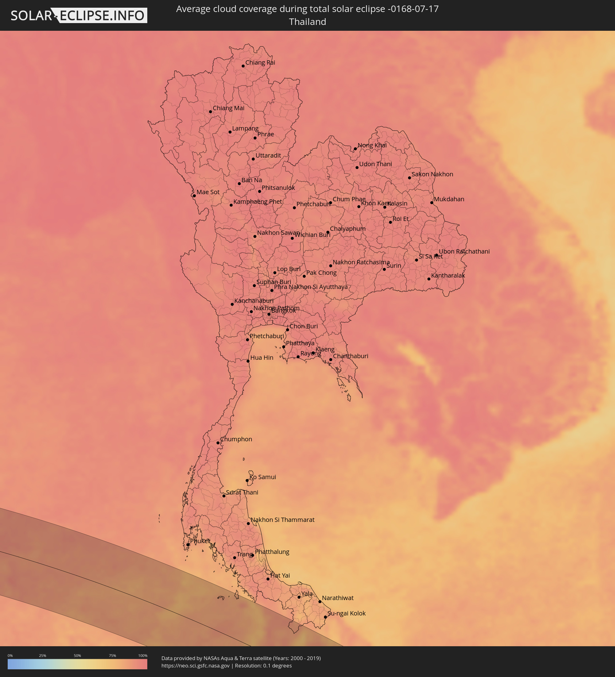 Thailand
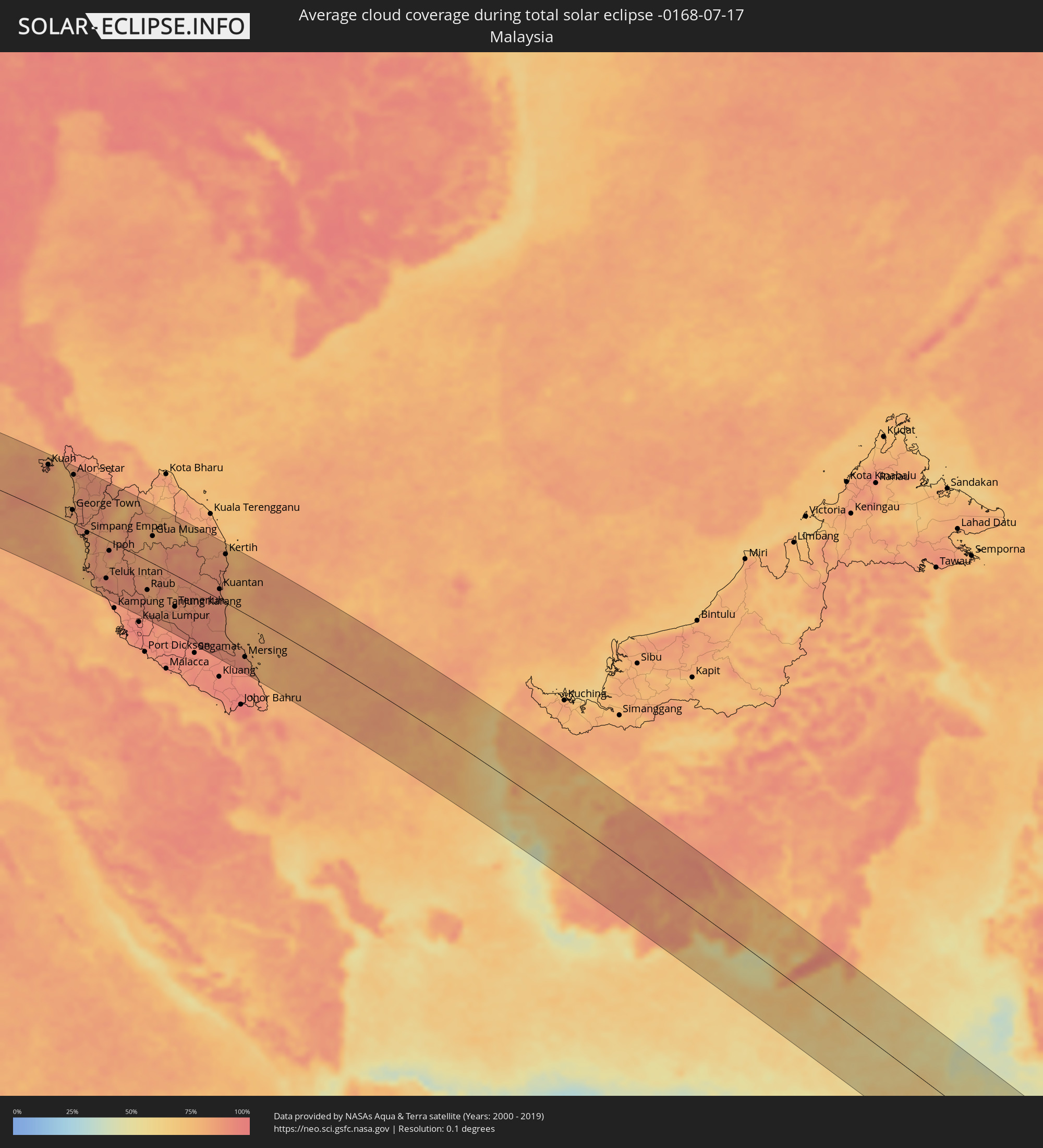 Malaysia
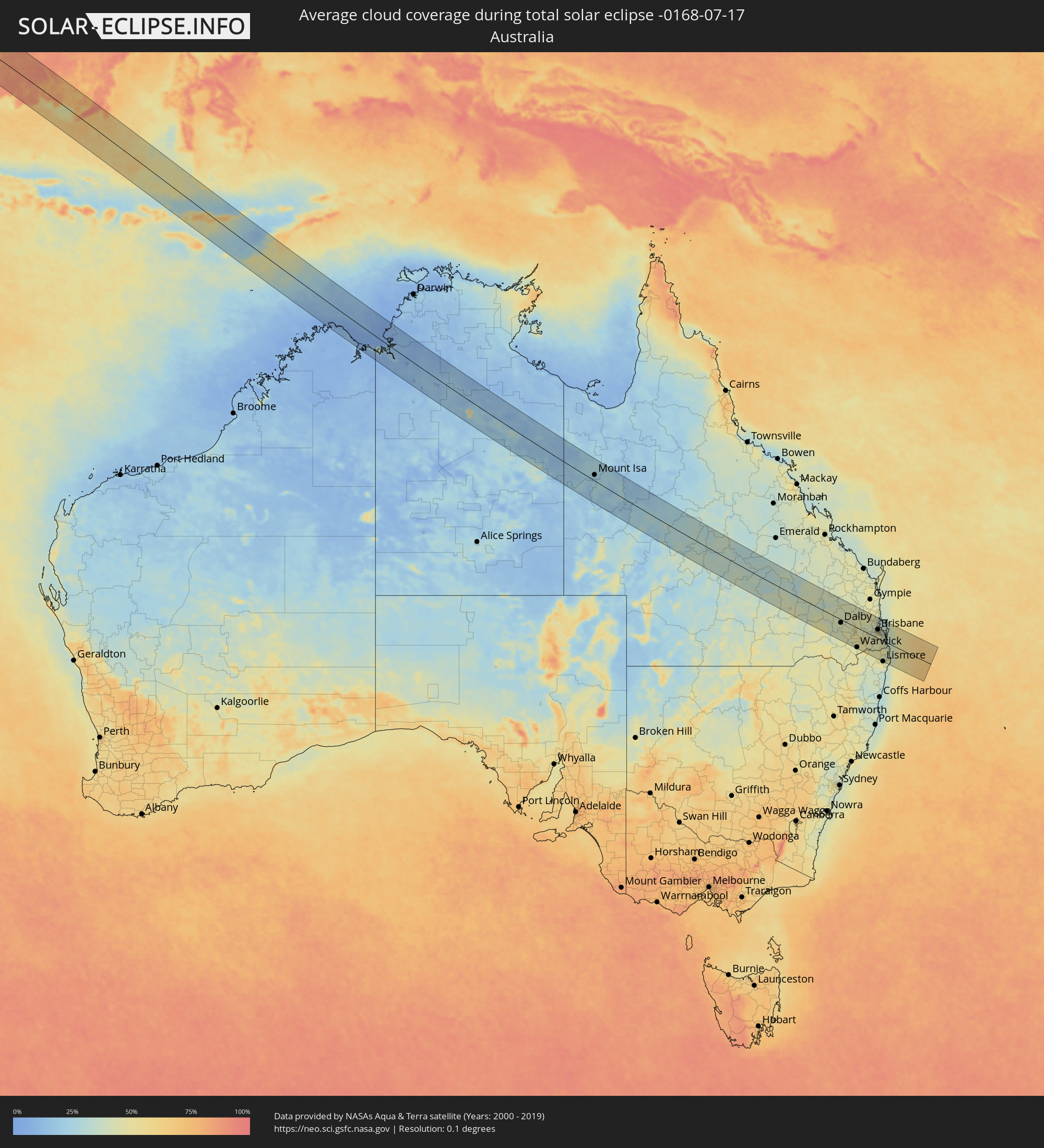 Australia
Cities inside the path of the eclipse
The following table shows all locations with a population of more than 5,000 inside the eclipse path. Cities which have more than 100,000 inhabitants are marked bold. A click at the locations opens a detailed map.
| City | Type | Eclipse duration | Local time of max. eclipse | Distance to central line | Ø Cloud coverage |
|
Hola, Tana River
|
total | - | 05:56:53 UTC+02:27 | 57 km | 83% |
|
Witu, Lamu
|
total | - | 05:57:07 UTC+02:27 | 53 km | 75% |
|
Lamu, Lamu
|
total | - | 05:57:10 UTC+02:27 | 60 km | 59% |
|
Kismayo, Lower Juba
|
total | - | 05:57:07 UTC+02:27 | 69 km | 69% |
|
Cochin, Kerala
|
total | - | 09:25:18 UTC+05:21 | 108 km | 92% |
|
Alleppey, Kerala
|
total | - | 09:25:32 UTC+05:21 | 58 km | 92% |
|
Cherthala, Kerala
|
total | - | 09:25:31 UTC+05:21 | 79 km | 90% |
|
Kāyankulam, Kerala
|
total | - | 09:25:58 UTC+05:21 | 20 km | 91% |
|
Kottayam, Kerala
|
total | - | 09:25:55 UTC+05:21 | 66 km | 94% |
|
Tiruvalla, Kerala
|
total | - | 09:26:05 UTC+05:21 | 43 km | 95% |
|
Kollam, Kerala
|
total | - | 09:26:13 UTC+05:21 | 13 km | 92% |
|
Varkala, Kerala
|
total | - | 09:26:33 UTC+05:21 | 31 km | 91% |
|
Punalūr, Kerala
|
total | - | 09:26:56 UTC+05:21 | 1 km | 96% |
|
Thiruvananthapuram, Kerala
|
total | - | 09:27:06 UTC+05:21 | 61 km | 91% |
|
Neyyāttinkara, Kerala
|
total | - | 09:27:25 UTC+05:21 | 72 km | 89% |
|
Cumbum, Tamil Nadu
|
total | - | 09:27:30 UTC+05:21 | 75 km | 96% |
|
Kadayanallur, Tamil Nadu
|
total | - | 09:27:47 UTC+05:21 | 0 km | 94% |
|
Nāgercoil, Tamil Nadu
|
total | - | 09:28:15 UTC+05:21 | 100 km | 90% |
|
Teni, Tamil Nadu
|
total | - | 09:27:51 UTC+05:21 | 104 km | 93% |
|
Rajapalaiyam, Tamil Nadu
|
total | - | 09:28:09 UTC+05:21 | 40 km | 93% |
|
Tirunelveli, Tamil Nadu
|
total | - | 09:28:38 UTC+05:21 | 41 km | 94% |
|
Sivakasi, Tamil Nadu
|
total | - | 09:28:40 UTC+05:21 | 38 km | 89% |
|
Kovilpatti, Tamil Nadu
|
total | - | 09:28:55 UTC+05:21 | 6 km | 88% |
|
Virudunagar, Tamil Nadu
|
total | - | 09:28:59 UTC+05:21 | 51 km | 88% |
|
Aruppukkottai, Tamil Nadu
|
total | - | 09:29:18 UTC+05:21 | 42 km | 89% |
|
Madurai, Tamil Nadu
|
total | - | 09:29:15 UTC+05:21 | 87 km | 92% |
|
Paramagudi, Tamil Nadu
|
total | - | 09:30:23 UTC+05:21 | 42 km | 91% |
|
Kāraikkudi, Tamil Nadu
|
total | - | 09:30:38 UTC+05:21 | 99 km | 92% |
|
Ramanathapuram, Tamil Nadu
|
total | - | 09:30:59 UTC+05:21 | 21 km | 93% |
|
Jaffna, Northern Province
|
total | - | 09:31:56 UTC+05:19 | 47 km | 86% |
|
Valvedditturai, Northern Province
|
total | - | 09:32:15 UTC+05:19 | 63 km | 91% |
|
Point Pedro, Northern Province
|
total | - | 09:32:25 UTC+05:19 | 63 km | 91% |
|
Kilinochchi, Northern Province
|
total | - | 09:32:57 UTC+05:19 | 15 km | 87% |
|
Anuradhapura, North Central
|
total | - | 09:33:24 UTC+05:19 | 105 km | 90% |
|
Vavuniya, Northern Province
|
total | - | 09:33:26 UTC+05:19 | 57 km | 89% |
|
Trincomalee, Eastern Province
|
total | - | 09:35:17 UTC+05:19 | 79 km | 82% |
|
Kuah, Kedah
|
total | - | 12:05:27 UTC+06:55 | 97 km | 84% |
|
George Town, Penang
|
total | - | 12:07:59 UTC+06:55 | 27 km | 83% |
|
Alor Setar, Kedah
|
total | - | 12:07:10 UTC+06:55 | 100 km | 81% |
|
Permatang Kuching, Penang
|
total | - | 12:08:03 UTC+06:55 | 35 km | 84% |
|
Jitra, Kedah
|
total | - | 12:07:10 UTC+06:55 | 117 km | 86% |
|
Bukit Mertajam, Penang
|
total | - | 12:08:25 UTC+06:55 | 29 km | 88% |
|
Nibong Tebal, Penang
|
total | - | 12:08:42 UTC+06:55 | 9 km | 89% |
|
Sungai Petani, Kedah
|
total | - | 12:08:08 UTC+06:55 | 58 km | 89% |
|
Parit Buntar, Perak
|
total | - | 12:08:48 UTC+06:55 | 6 km | 89% |
|
Lumut, Perak
|
total | - | 12:10:19 UTC+06:55 | 77 km | 78% |
|
Simpang Empat, Perak
|
total | - | 12:09:25 UTC+06:55 | 5 km | 83% |
|
Taiping, Perak
|
total | - | 12:09:50 UTC+06:55 | 10 km | 86% |
|
Kuala Kangsar, Perak
|
total | - | 12:10:30 UTC+06:55 | 9 km | 84% |
|
Sungai Besar, Selangor
|
total | - | 12:12:03 UTC+06:55 | 115 km | 83% |
|
Teluk Intan, Perak
|
total | - | 12:11:42 UTC+06:55 | 78 km | 89% |
|
Betong, Yala
|
total | - | 11:56:16 UTC+06:42 | 99 km | 85% |
|
Ipoh, Perak
|
total | - | 12:11:09 UTC+06:55 | 19 km | 90% |
|
Bidur, Perak
|
total | - | 12:12:19 UTC+06:55 | 56 km | 87% |
|
Serendah, Selangor
|
total | - | 12:14:12 UTC+06:55 | 114 km | 90% |
|
Raub, Pahang
|
total | - | 12:14:22 UTC+06:55 | 59 km | 81% |
|
Bentong Town, Pahang
|
total | - | 12:14:51 UTC+06:55 | 83 km | 88% |
|
Jerantut, Pahang
|
total | - | 12:15:35 UTC+06:55 | 18 km | 82% |
|
Temerluh, Pahang
|
total | - | 12:16:22 UTC+06:55 | 63 km | 86% |
|
Kuantan, Pahang
|
total | - | 12:18:25 UTC+06:55 | 20 km | 90% |
|
Pekan, Pahang
|
total | - | 12:19:02 UTC+06:55 | 7 km | 89% |
|
Cukai, Terengganu
|
total | - | 12:18:05 UTC+06:55 | 68 km | 87% |
|
Sungai Raya, West Kalimantan
|
total | - | 12:48:43 UTC+07:07 | 50 km | 63% |
|
Pemangkat, West Kalimantan
|
total | - | 12:48:16 UTC+07:07 | 97 km | 77% |
|
Singkawang, West Kalimantan
|
total | - | 12:48:39 UTC+07:07 | 75 km | 79% |
|
Pontianak, West Kalimantan
|
total | - | 12:50:42 UTC+07:07 | 9 km | 82% |
|
Manismata, West Kalimantan
|
total | - | 12:57:47 UTC+07:07 | 105 km | 88% |
|
Pangkalanbuun, Central Kalimantan
|
total | - | 12:59:23 UTC+07:07 | 86 km | 88% |
|
Sampit, Central Kalimantan
|
total | - | 13:02:04 UTC+07:07 | 14 km | 85% |
|
Palangkaraya, Central Kalimantan
|
total | - | 13:03:42 UTC+07:07 | 106 km | 83% |
|
Kualakapuas, Central Kalimantan
|
total | - | 13:05:39 UTC+07:07 | 65 km | 71% |
|
Banjarmasin, South Kalimantan
|
total | - | 13:56:50 UTC+07:57 | 51 km | 73% |
|
Martapura, South Kalimantan
|
total | - | 13:57:29 UTC+07:57 | 61 km | 72% |
|
Labuan Bajo, East Nusa Tenggara
|
total | - | 14:12:02 UTC+07:57 | 59 km | 49% |
|
Ruteng, East Nusa Tenggara
|
total | - | 14:13:04 UTC+07:57 | 31 km | 76% |
|
Ende, East Nusa Tenggara
|
total | - | 14:15:09 UTC+07:57 | 28 km | 65% |
|
Maumere, East Nusa Tenggara
|
total | - | 14:15:46 UTC+07:57 | 84 km | 43% |
|
Kupang, East Nusa Tenggara
|
total | - | 14:19:08 UTC+07:57 | 37 km | 39% |
|
Mount Isa, Queensland
|
total | - | 16:42:18 UTC+10:00 | 25 km | 22% |
|
Dalby, Queensland
|
total | - | 16:47:03 UTC+10:00 | 14 km | 46% |
|
Kingaroy, Queensland
|
total | - | 16:47:15 UTC+10:00 | 76 km | 43% |
|
Toowoomba, Queensland
|
total | - | 16:47:08 UTC+10:00 | 20 km | 49% |
|
Warwick, Queensland
|
total | - | 16:47:03 UTC+10:00 | 82 km | 45% |
|
Gatton, Queensland
|
total | - | 16:47:12 UTC+10:00 | 6 km | 47% |
|
Booval, Queensland
|
total | - | 16:47:16 UTC+10:00 | 11 km | 43% |
|
Samford Valley, Queensland
|
total | - | 16:47:19 UTC+10:00 | 39 km | 43% |
|
Springfield, Queensland
|
total | - | 16:47:17 UTC+10:00 | 13 km | 42% |
|
Caboolture, Queensland
|
total | - | 16:47:23 UTC+10:00 | 71 km | 39% |
|
Brisbane, Queensland
|
total | - | 16:47:20 UTC+10:00 | 37 km | 47% |
|
Windsor, Queensland
|
total | - | 16:47:20 UTC+10:00 | 40 km | 48% |
|
Bracken Ridge, Queensland
|
total | - | 16:47:22 UTC+10:00 | 52 km | 47% |
|
Margate, Queensland
|
total | - | 16:47:23 UTC+10:00 | 62 km | 35% |
|
Logan City, Queensland
|
total | - | 16:47:19 UTC+10:00 | 23 km | 47% |
|
Bongaree, Queensland
|
total | - | 16:47:25 UTC+10:00 | 81 km | 32% |
|
Tamborine Mountain, Queensland
|
total | - | 16:47:17 UTC+10:00 | 6 km | 42% |
|
Cleveland, Queensland
|
total | - | 16:47:22 UTC+10:00 | 41 km | 37% |
|
Lismore, New South Wales
|
total | - | 16:47:08 UTC+10:00 | 87 km | 48% |
|
Oxenford, Queensland
|
total | - | 16:47:19 UTC+10:00 | 7 km | 44% |
|
Murwillumbah, New South Wales
|
total | - | 16:47:15 UTC+10:00 | 33 km | 47% |
|
Gold Coast, Queensland
|
total | - | 16:47:19 UTC+10:00 | 1 km | 42% |
|
Banora Point, New South Wales
|
total | - | 16:47:17 UTC+10:00 | 15 km | 42% |
|
Ballina, New South Wales
|
total | - | 16:47:10 UTC+10:00 | 79 km | 40% |
|
Byron Bay, New South Wales
|
total | - | 16:47:13 UTC+10:00 | 55 km | 41% |