Annular solar eclipse of 09/07/-0208
| Day of week: | Wednesday |
| Maximum duration of eclipse: | 02m05s |
| Maximum width of eclipse path: | 74 km |
| Saros cycle: | 70 |
| Coverage: | 98% |
| Magnitude: | 0.9797 |
| Gamma: | -0.2462 |
Wo kann man die Sonnenfinsternis vom 09/07/-0208 sehen?
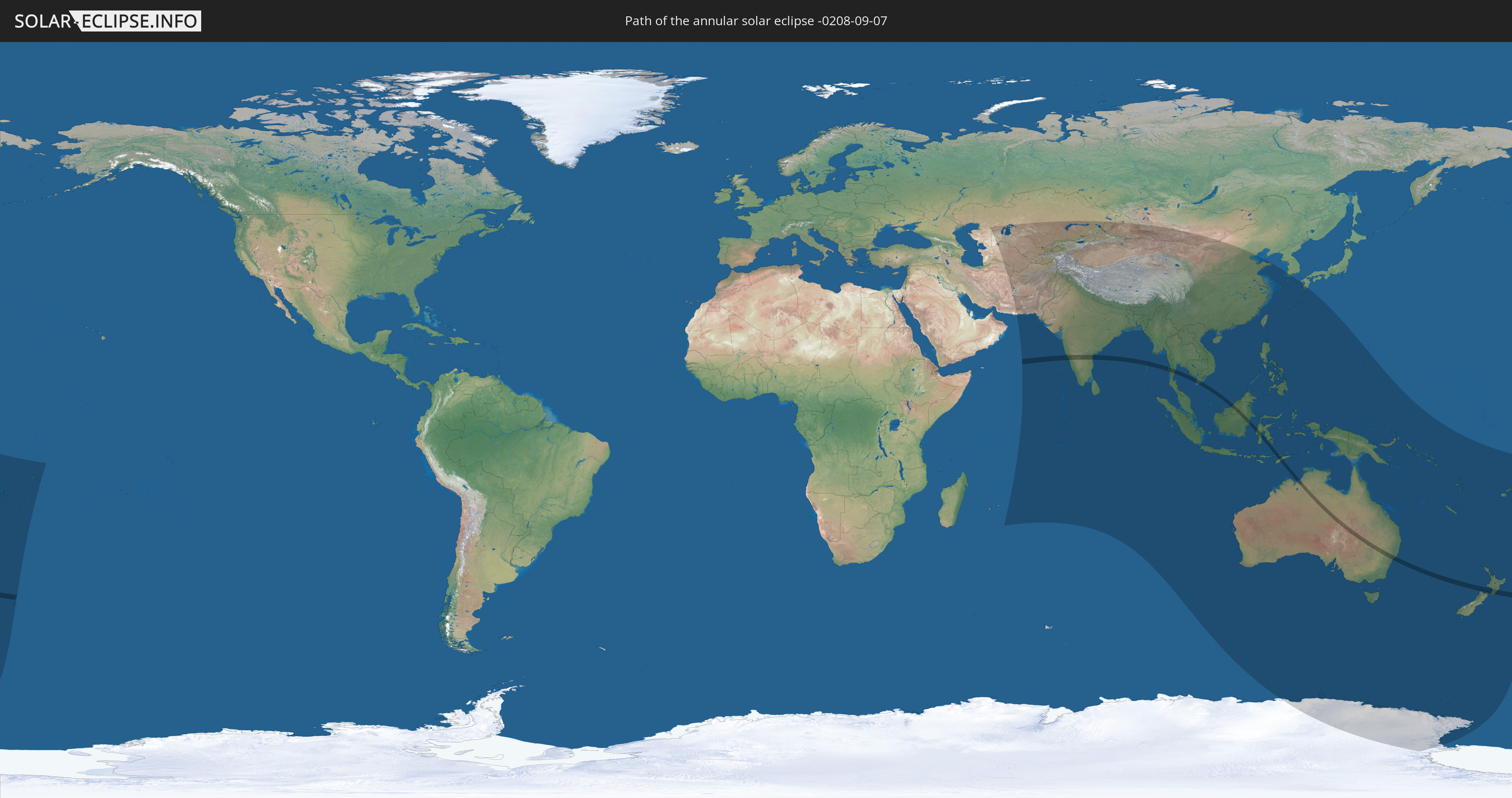
Die Sonnenfinsternis am 09/07/-0208 kann man in 54 Ländern als partielle Sonnenfinsternis beobachten.
Der Finsternispfad verläuft durch 10 Länder. Nur in diesen Ländern ist sie als annular Sonnenfinsternis zu sehen.
In den folgenden Ländern ist die Sonnenfinsternis annular zu sehen
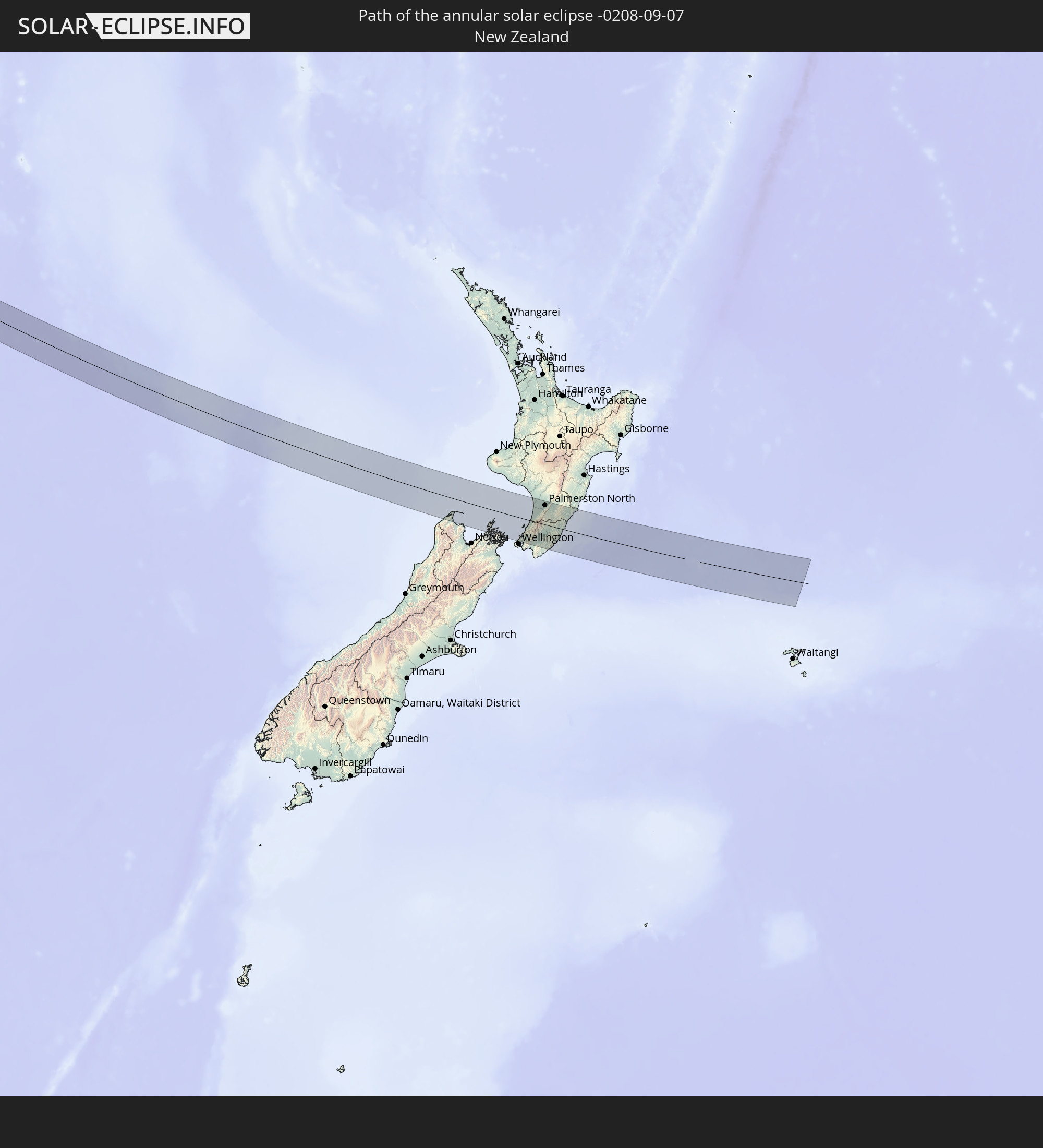 New Zealand
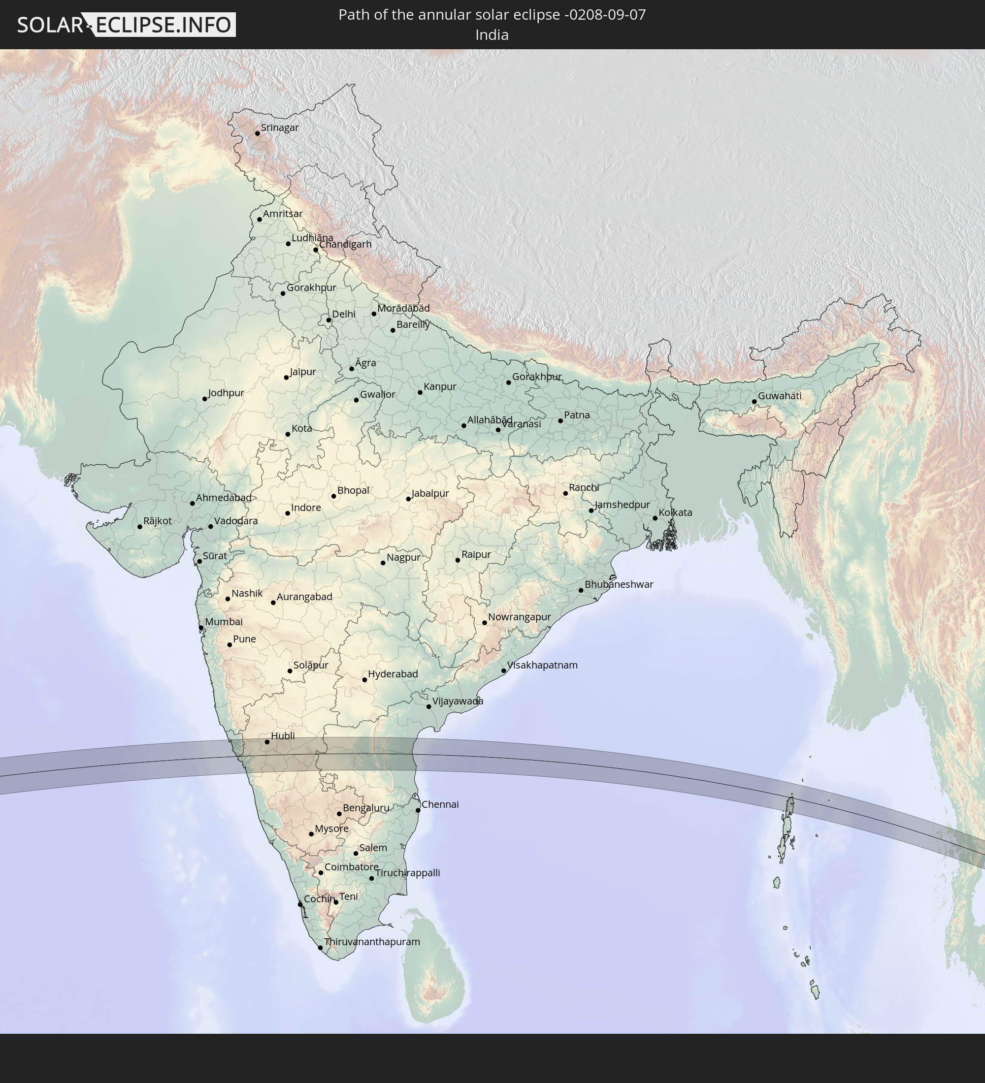 India
India
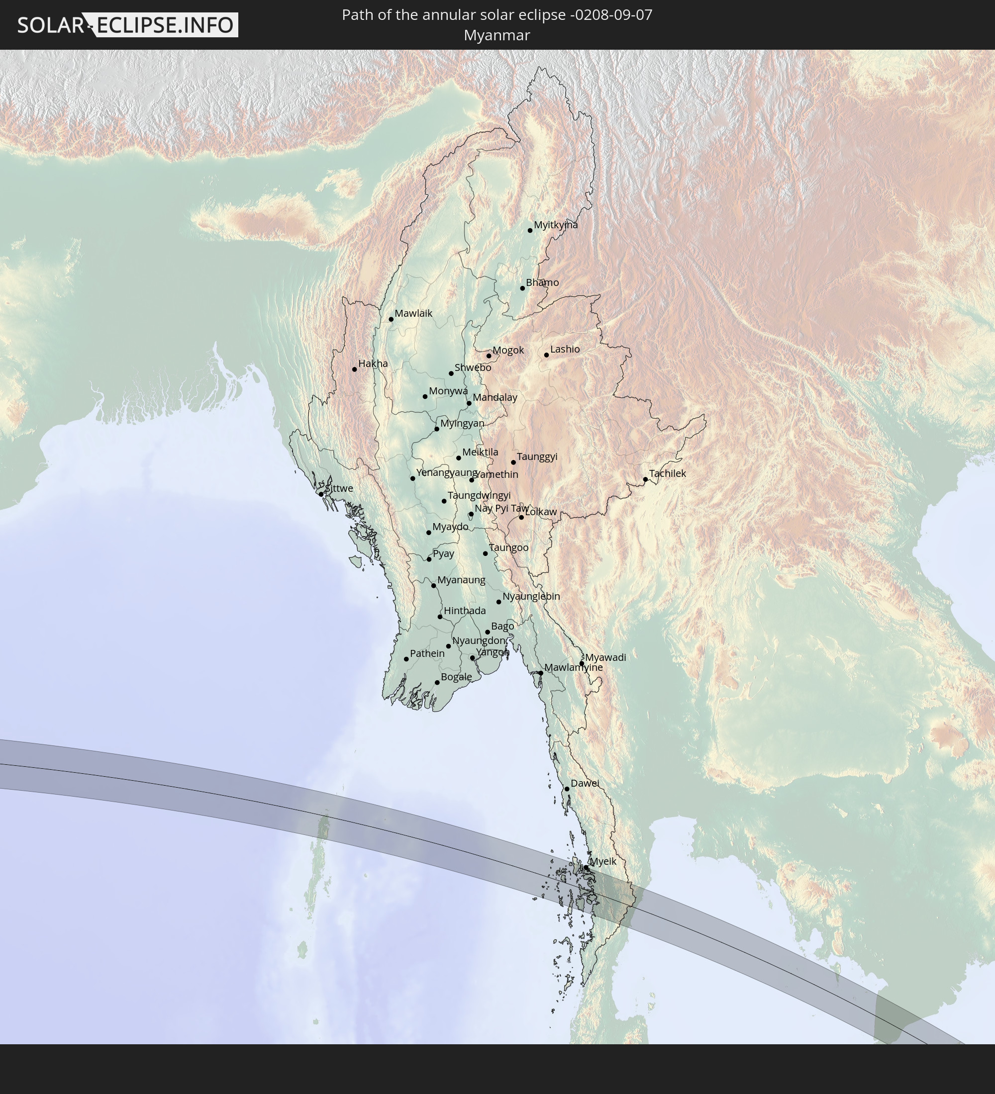 Myanmar
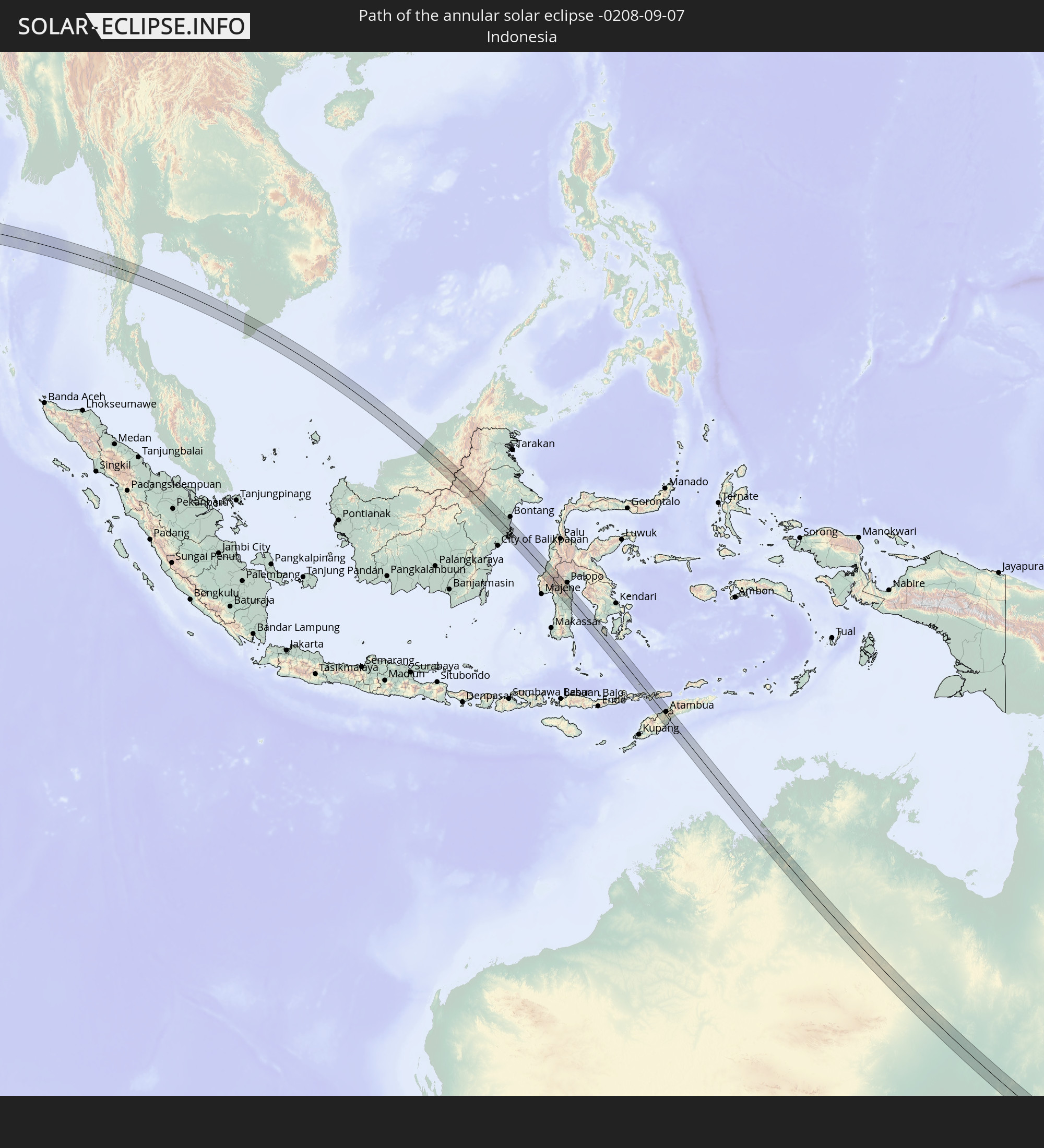 Indonesia
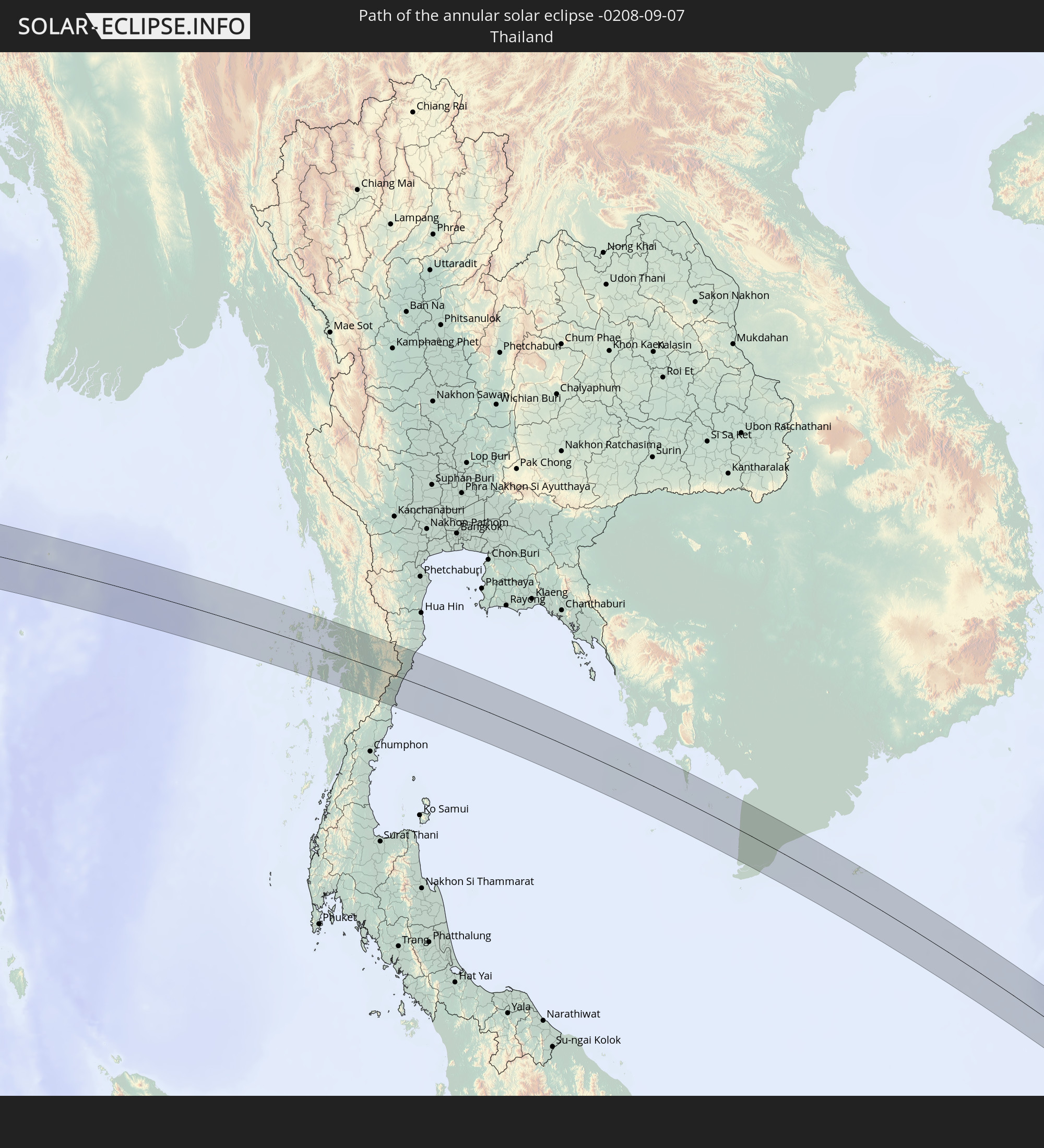 Thailand
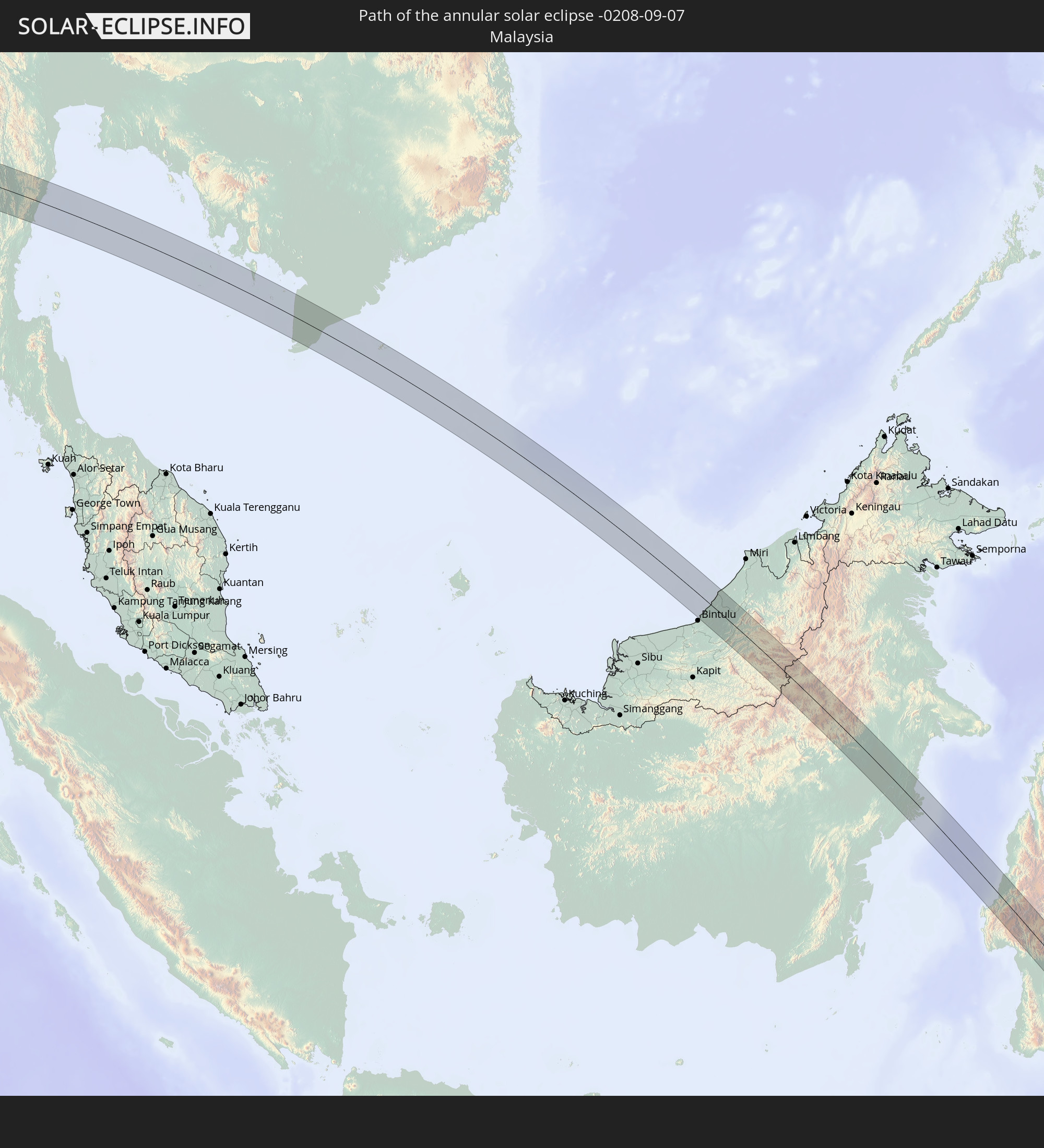 Malaysia
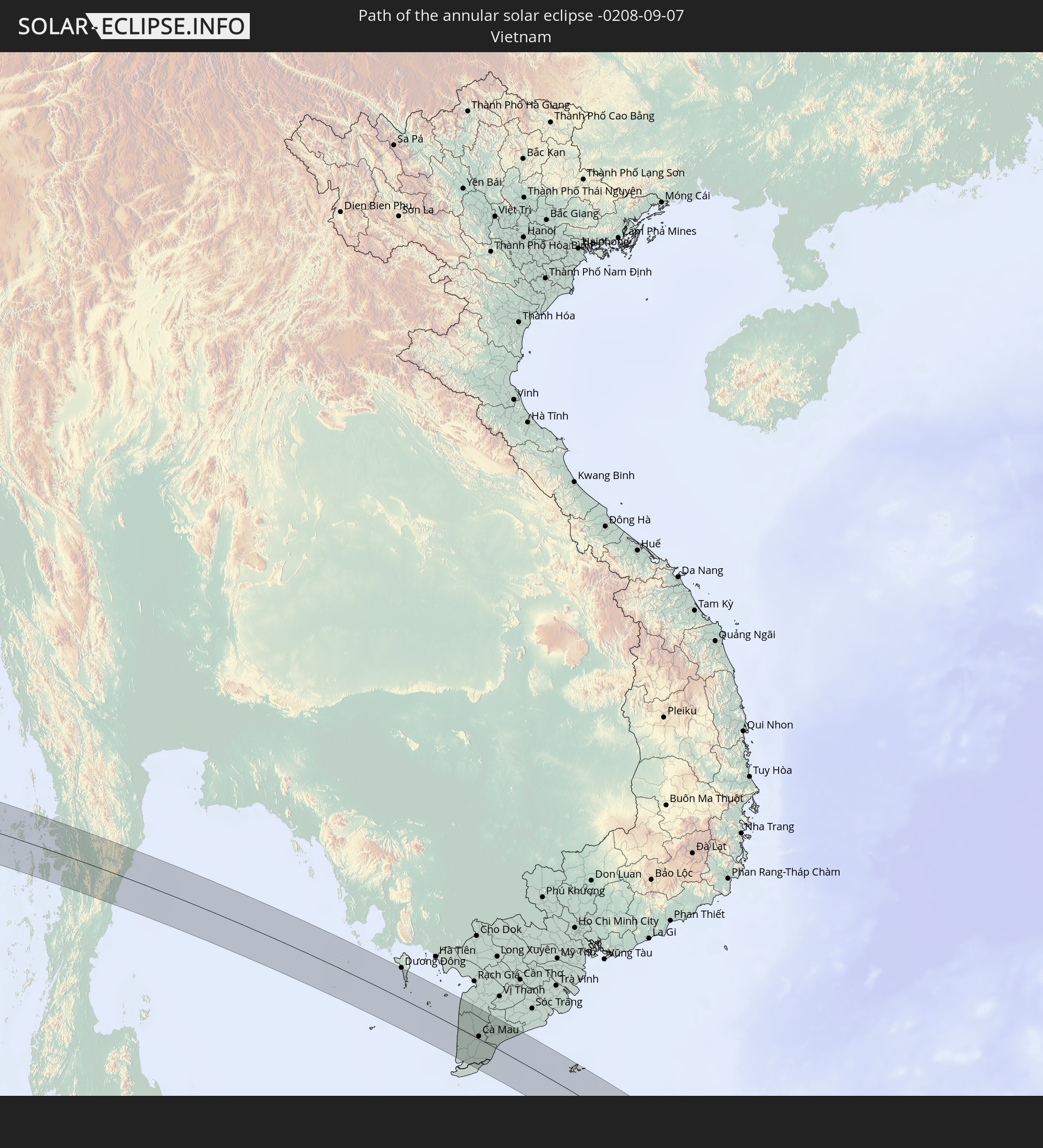 Vietnam
 Cambodia
 Australia
 East Timor
In den folgenden Ländern ist die Sonnenfinsternis partiell zu sehen
 Fiji
Fiji
 Antarctica
 New Zealand
 Wallis and Futuna
 Tonga
Tonga
 Samoa
Samoa
 American Samoa
 Iran
Iran
 Kazakhstan
 Turkmenistan
 Uzbekistan
 Mauritius
 Afghanistan
 Pakistan
 Tajikistan
 India
India
 Kyrgyzstan
 British Indian Ocean Territory
 Maldives
 China
China
 Sri Lanka
 Nepal
Nepal
 Mongolia
 Bangladesh
 Bhutan
 Myanmar
 Indonesia
 Cocos Islands
 Thailand
 Malaysia
 Laos
Laos
 Vietnam
 Cambodia
 Singapore
 Christmas Island
 Australia
 Macau
Macau
 Hong Kong
 Brunei
 Taiwan
 Philippines
 Japan
Japan
 East Timor
 South Korea
 Palau
Palau
 Federated States of Micronesia
 Papua New Guinea
 Guam
Guam
 Northern Mariana Islands
 Solomon Islands
 New Caledonia
 Vanuatu
 Norfolk Island
 Tuvalu
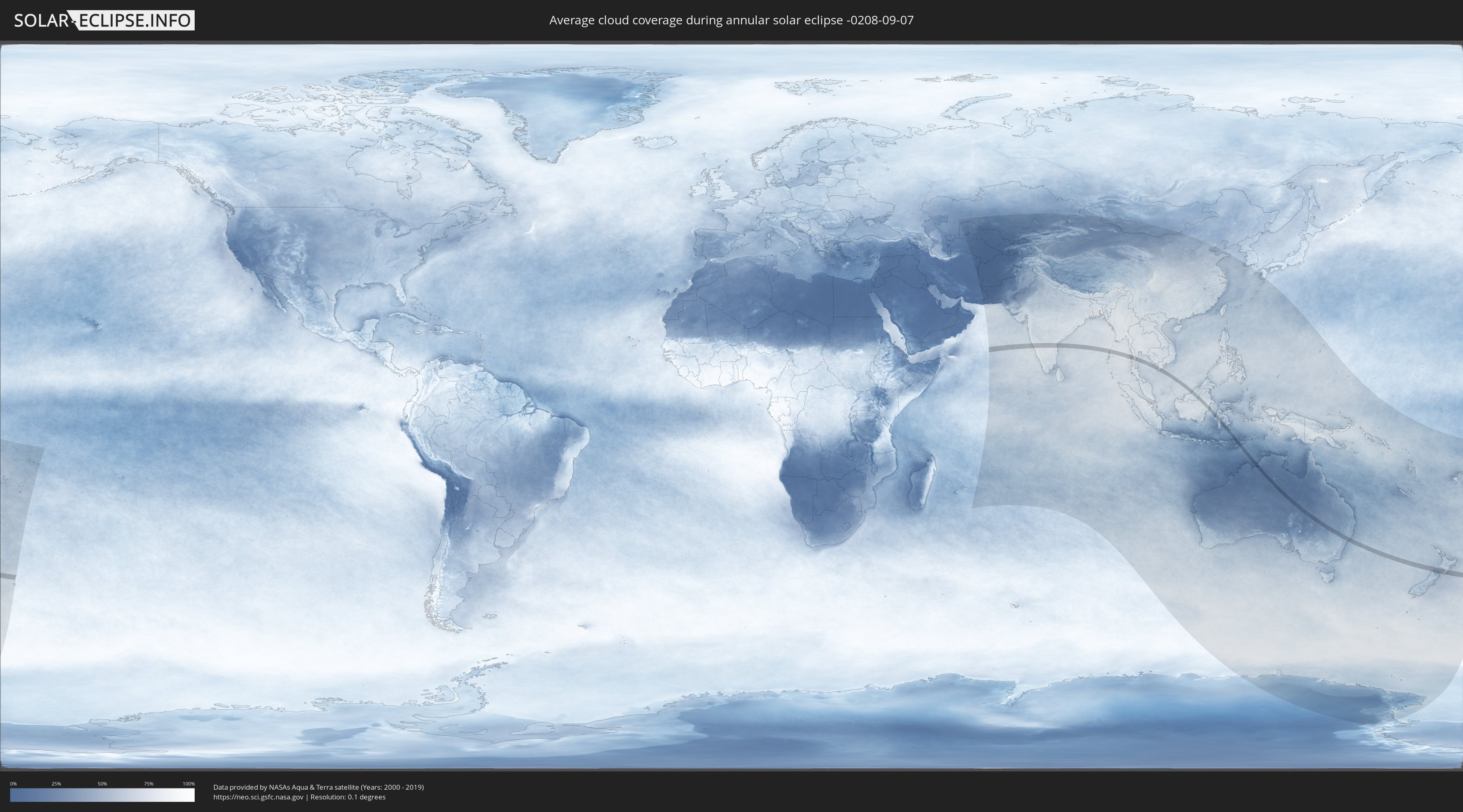
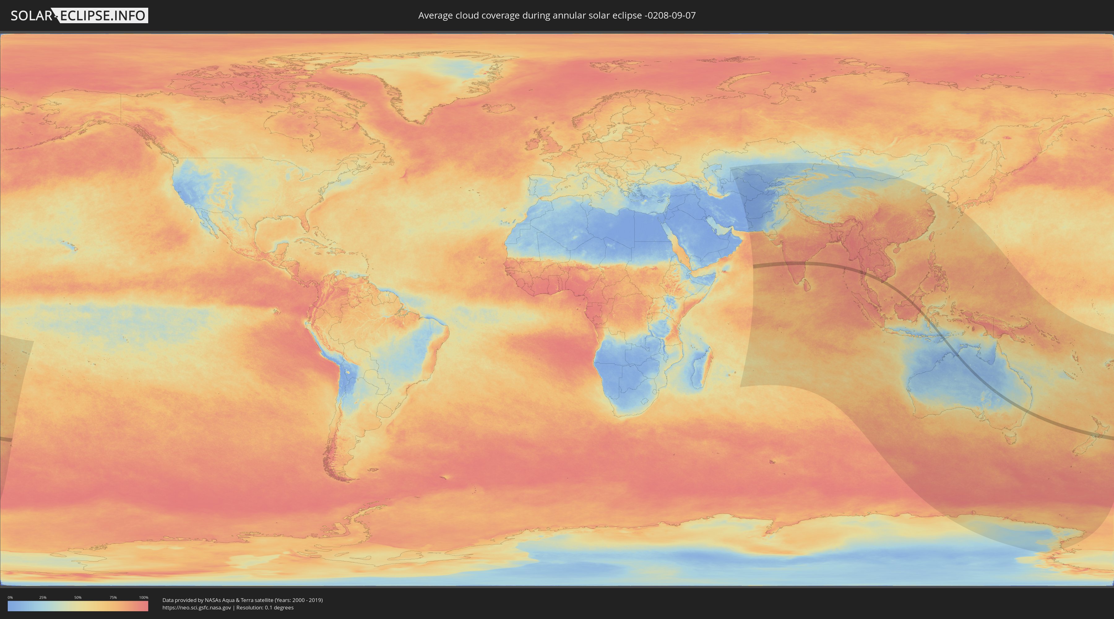
How will be the weather during the annular solar eclipse on 09/07/-0208?
Where is the best place to see the annular solar eclipse of 09/07/-0208?
The following maps show the average cloud coverage for the day of the annular solar eclipse.
With the help of these maps, it is possible to find the place along the eclipse path, which has the best
chance of a cloudless sky.
Nevertheless, you should consider local circumstances and inform about the weather of your chosen
observation site.
The data is provided by NASAs satellites
AQUA and TERRA.
The cloud maps are averaged over a period of 19 years (2000 - 2019).
Detailed country maps
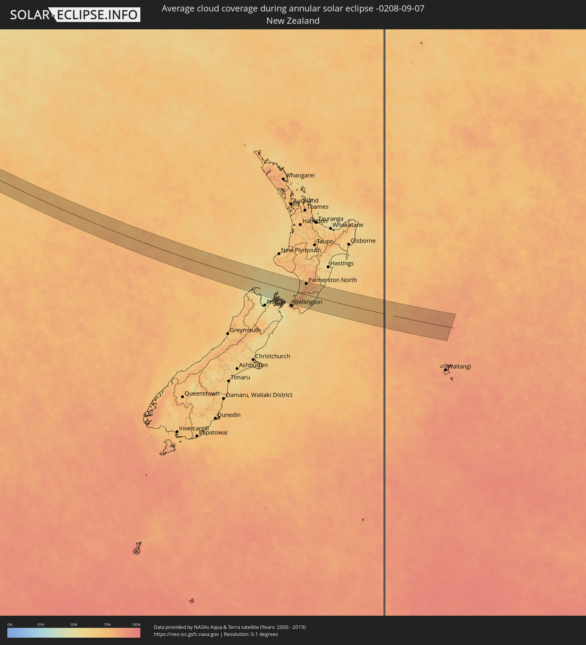 New Zealand
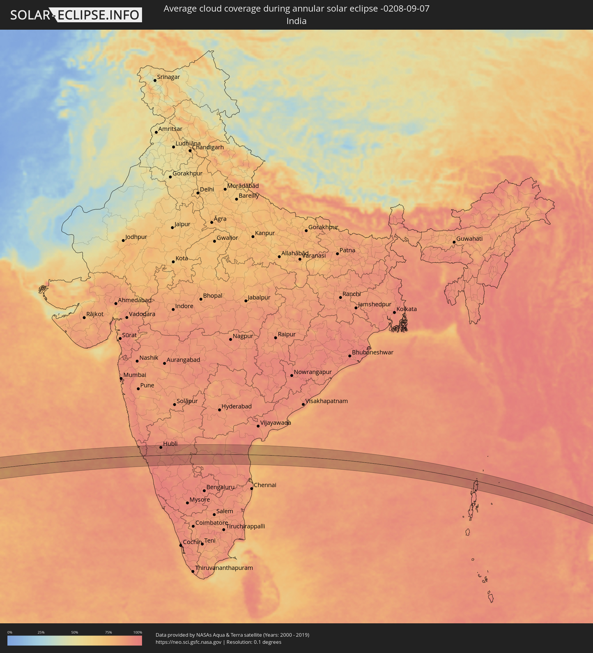 India
India
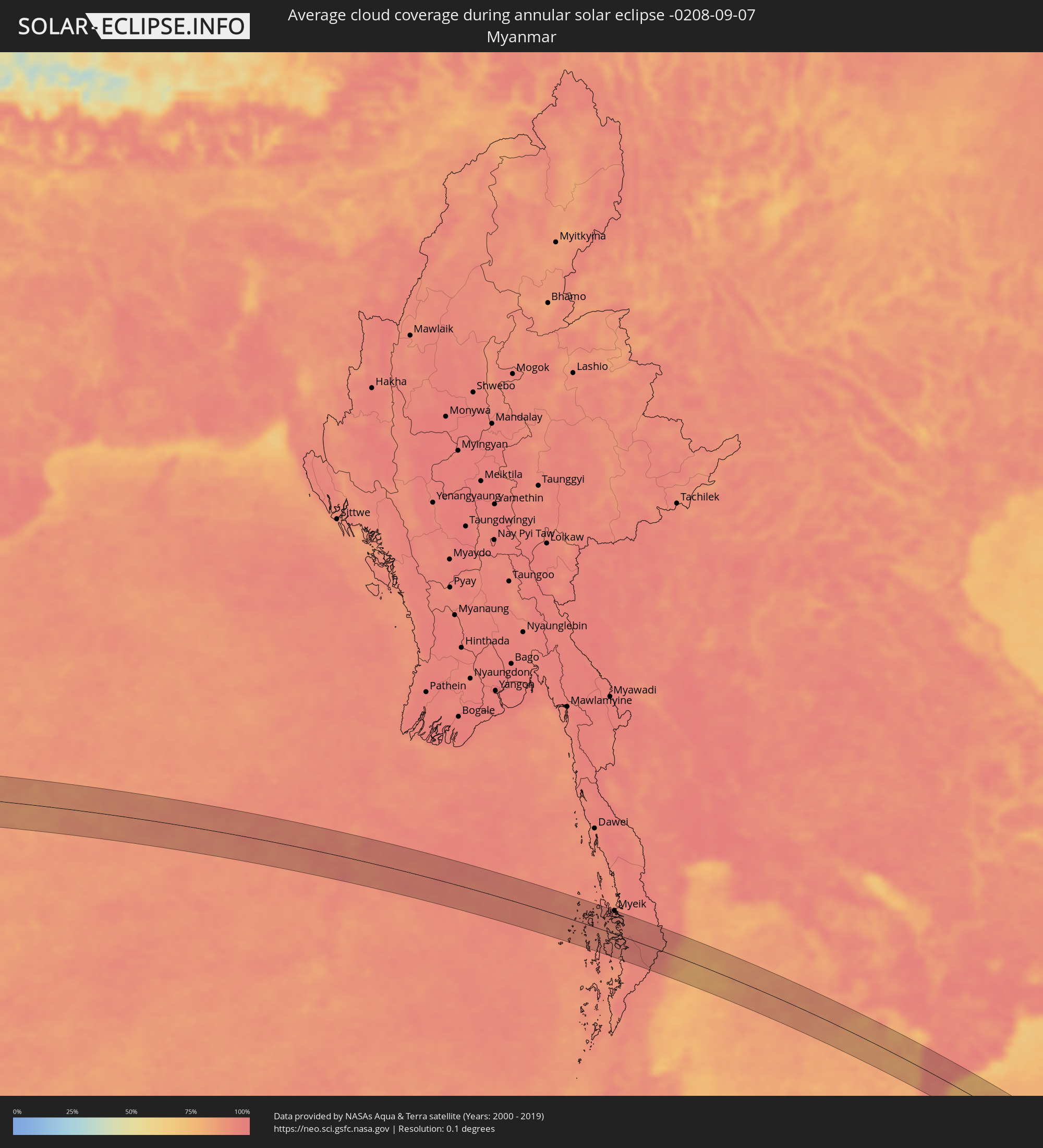 Myanmar
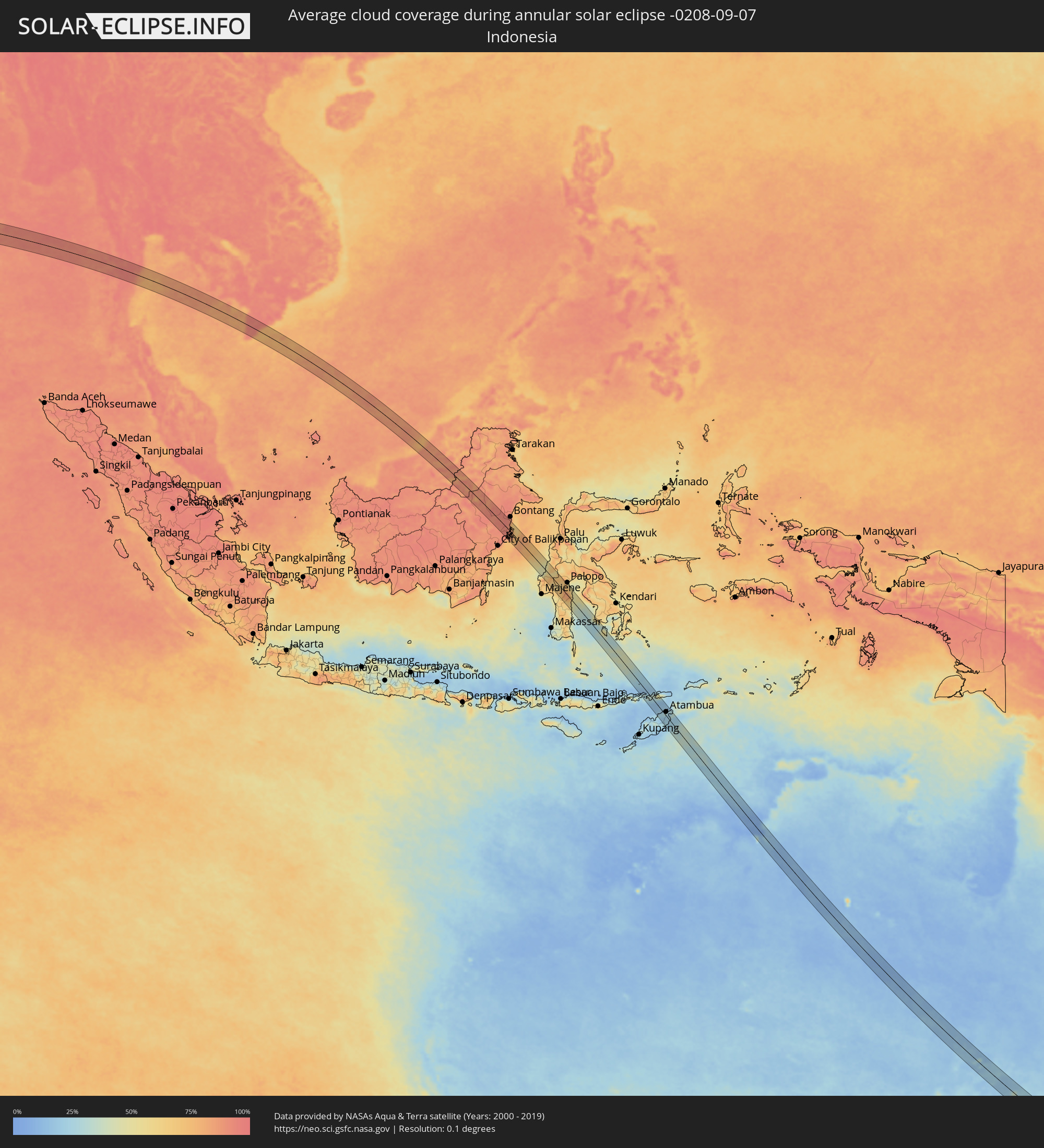 Indonesia
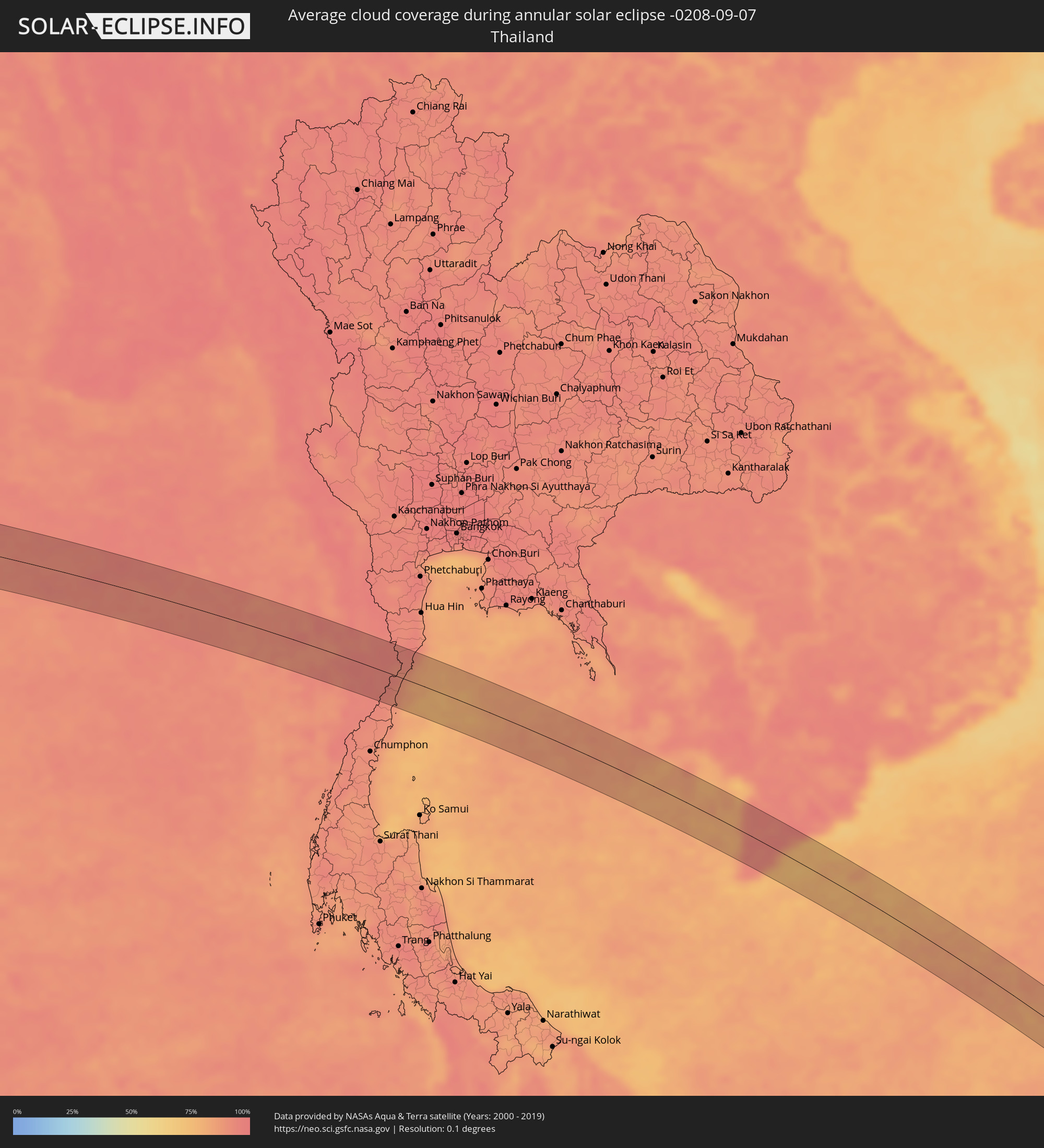 Thailand
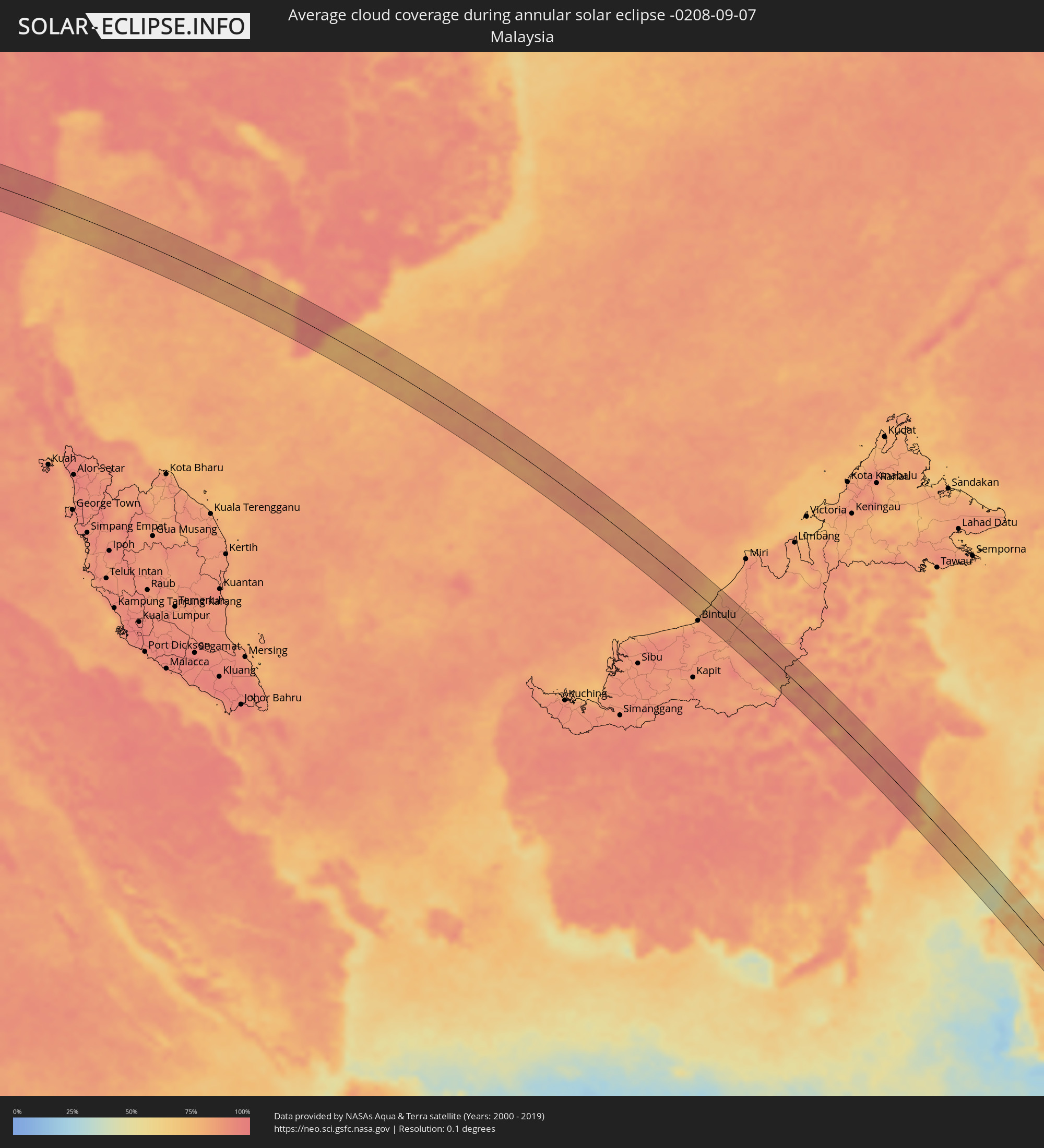 Malaysia
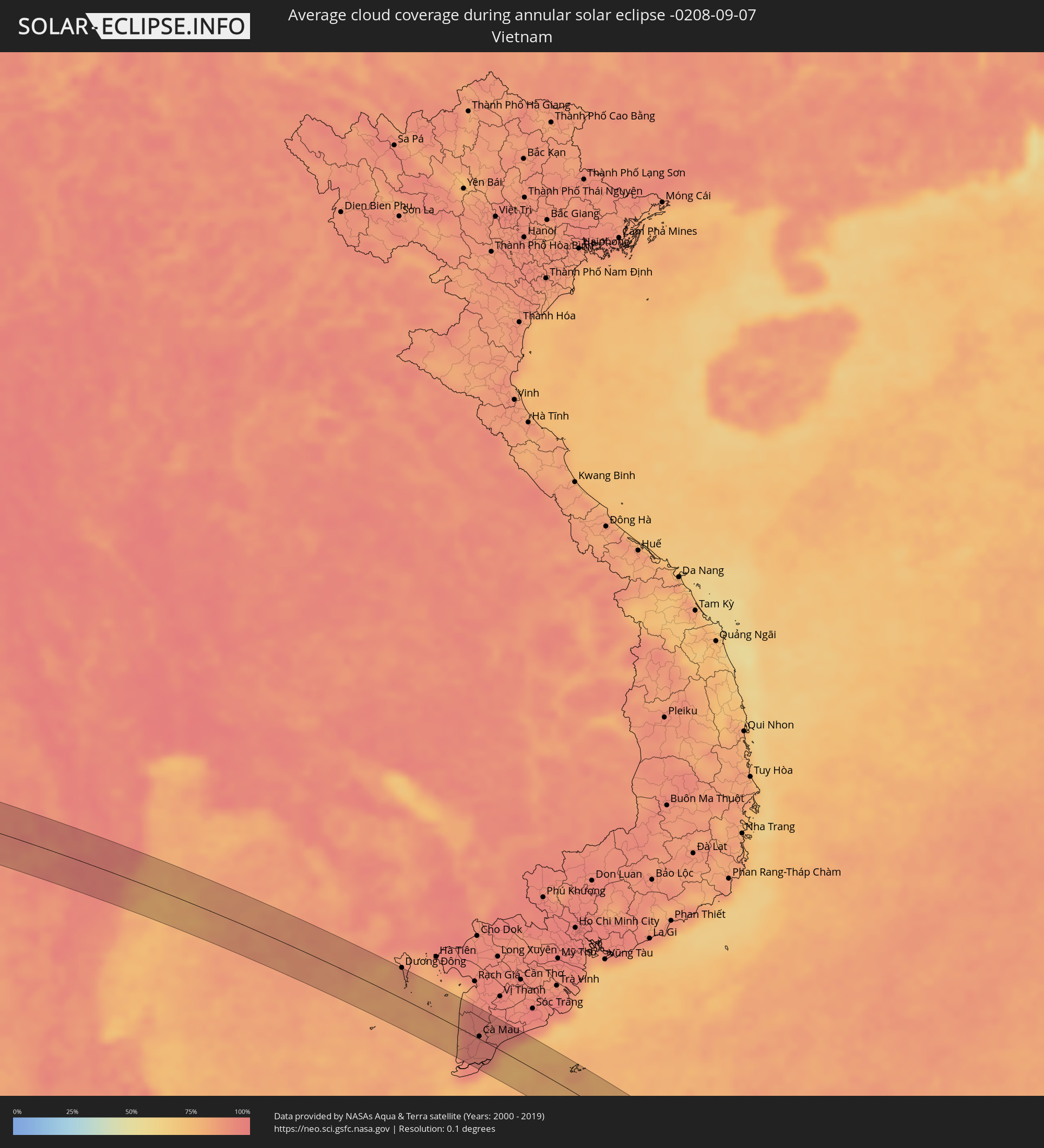 Vietnam
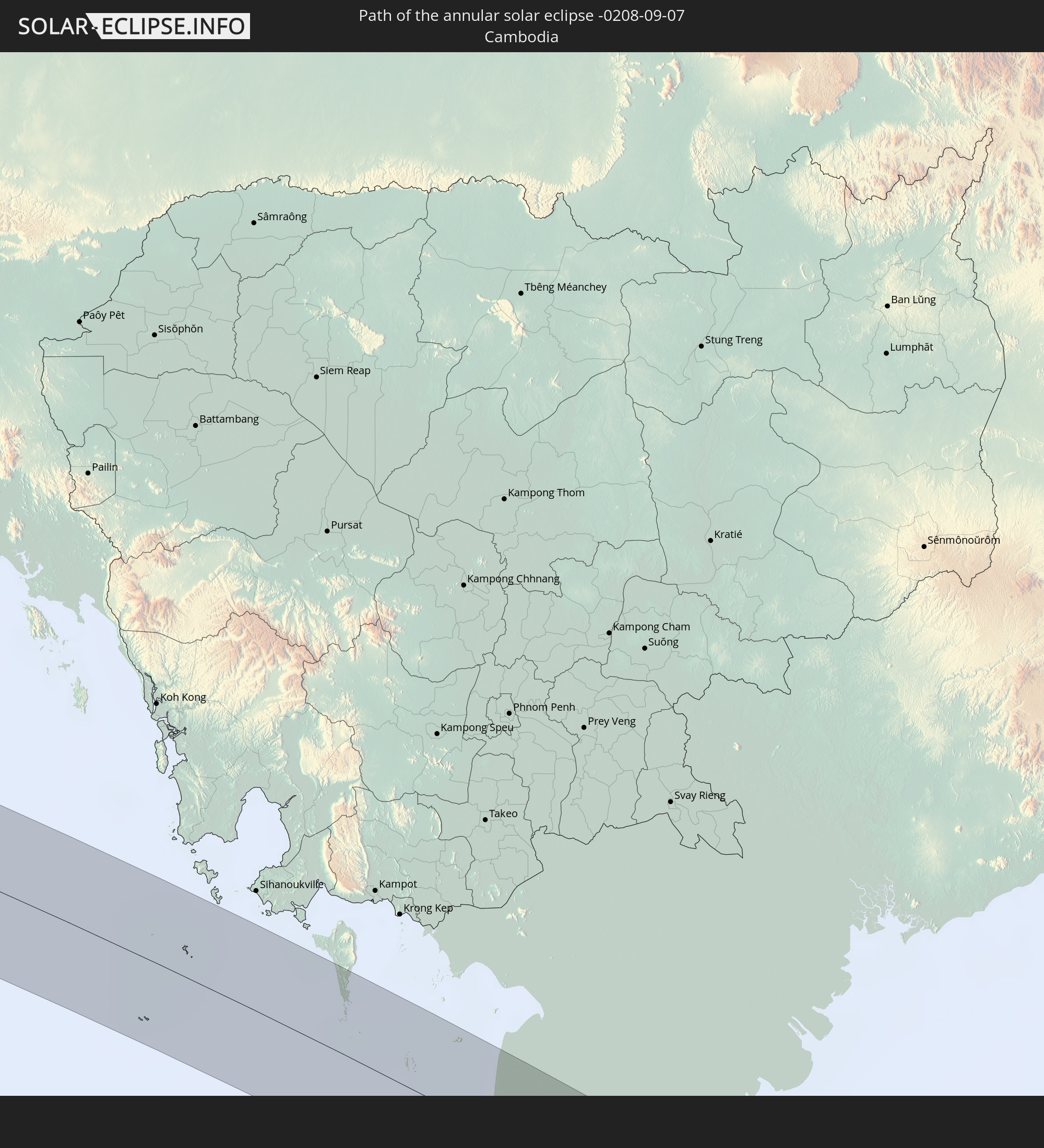
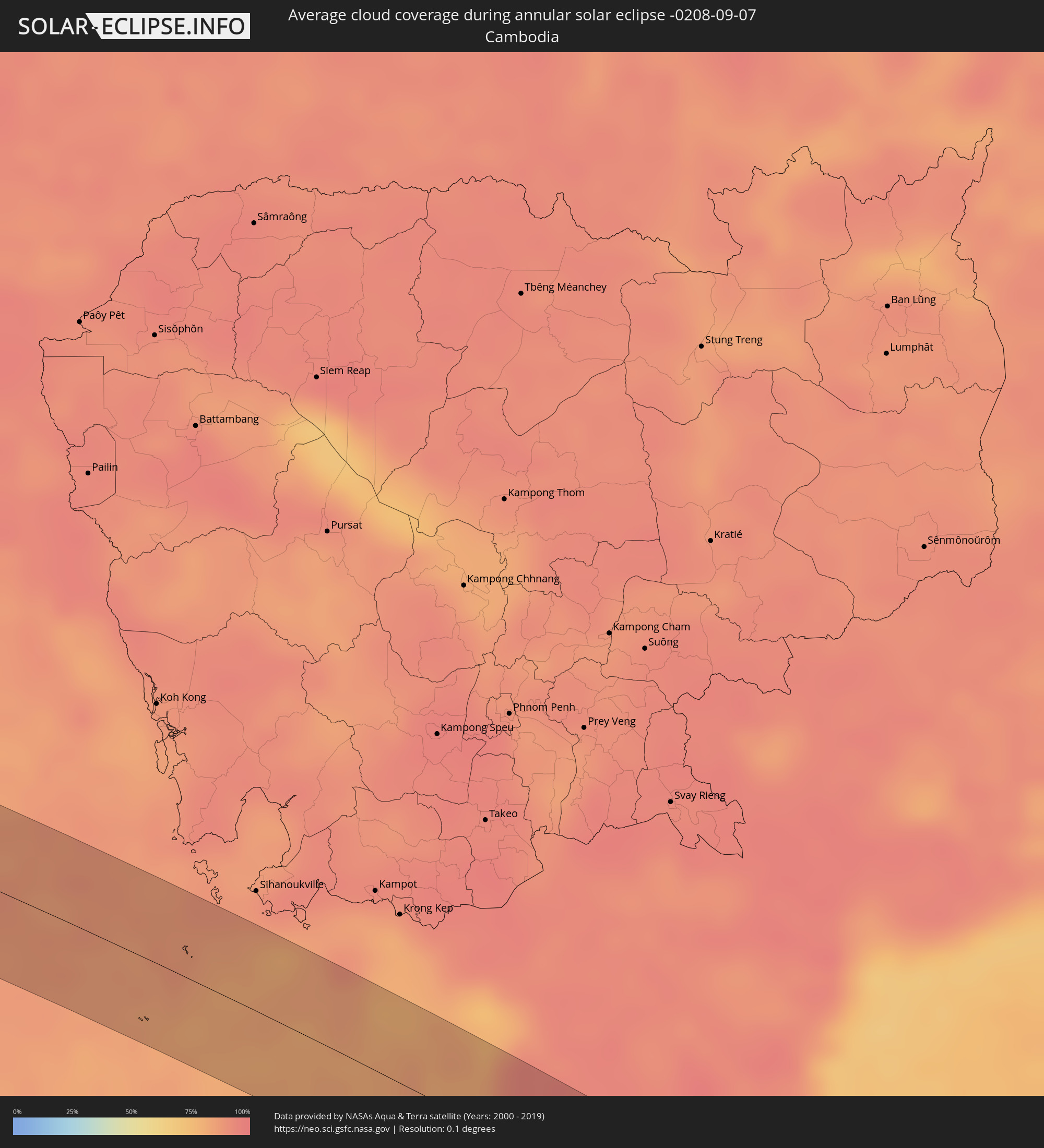 Cambodia
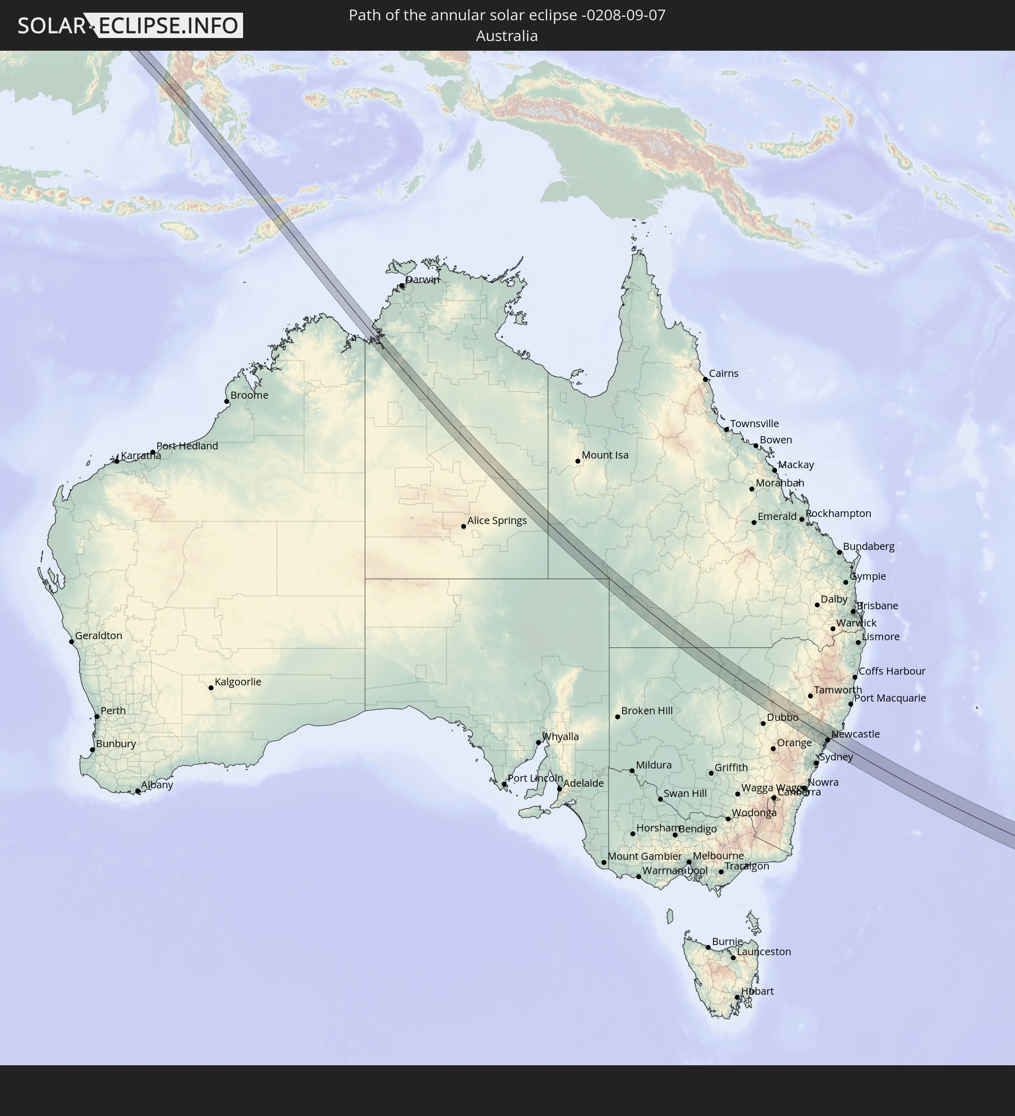
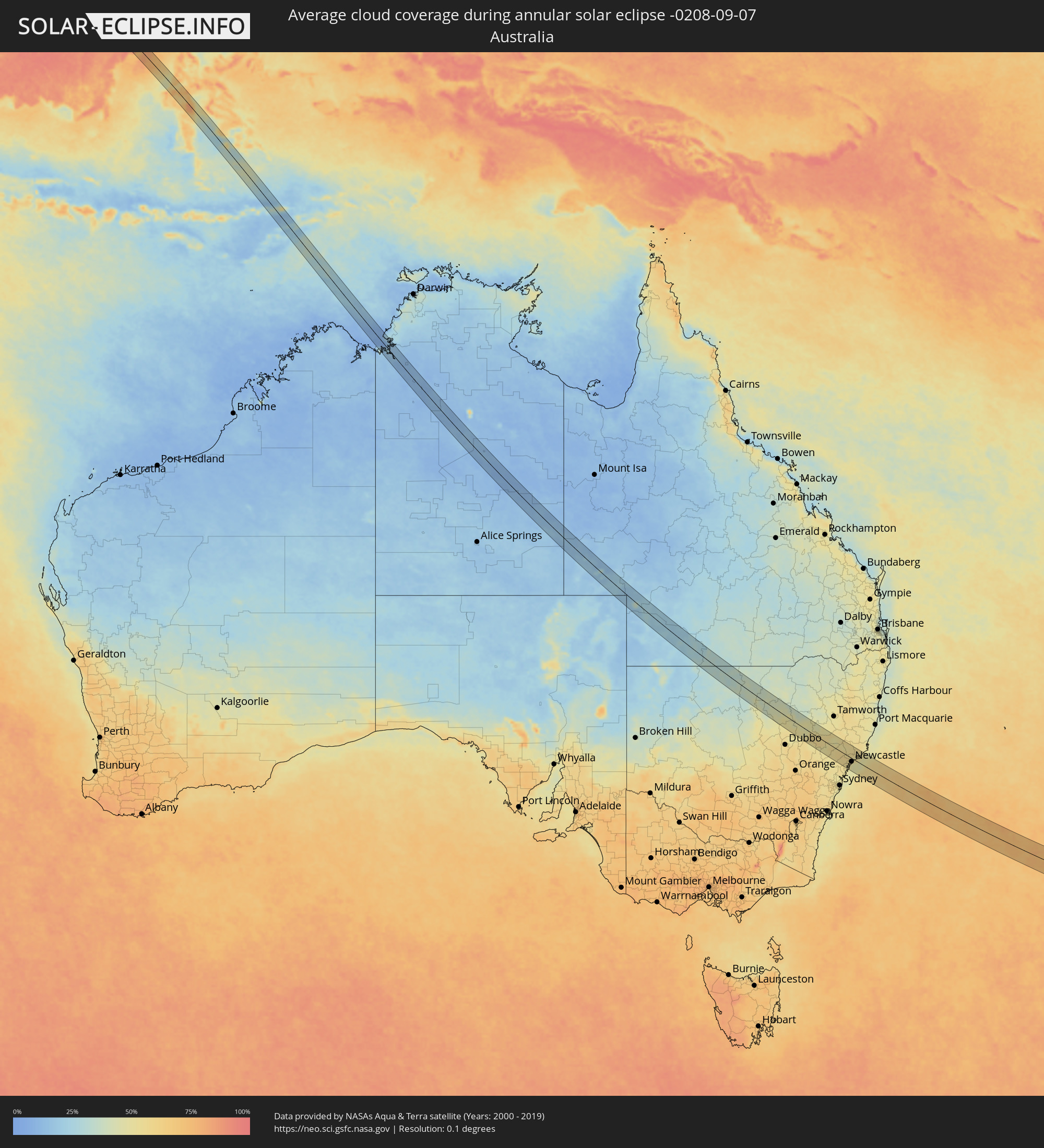 Australia
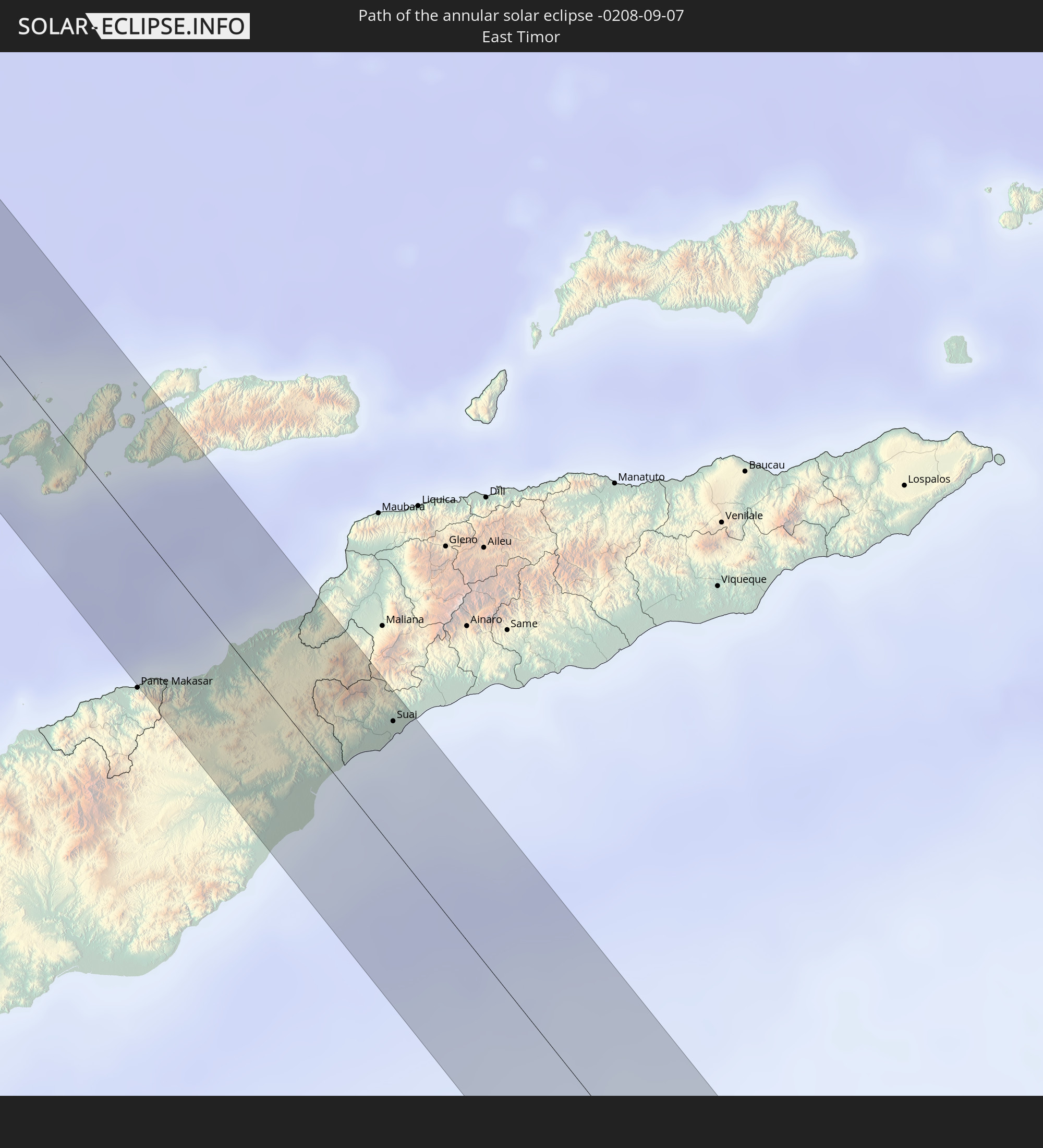
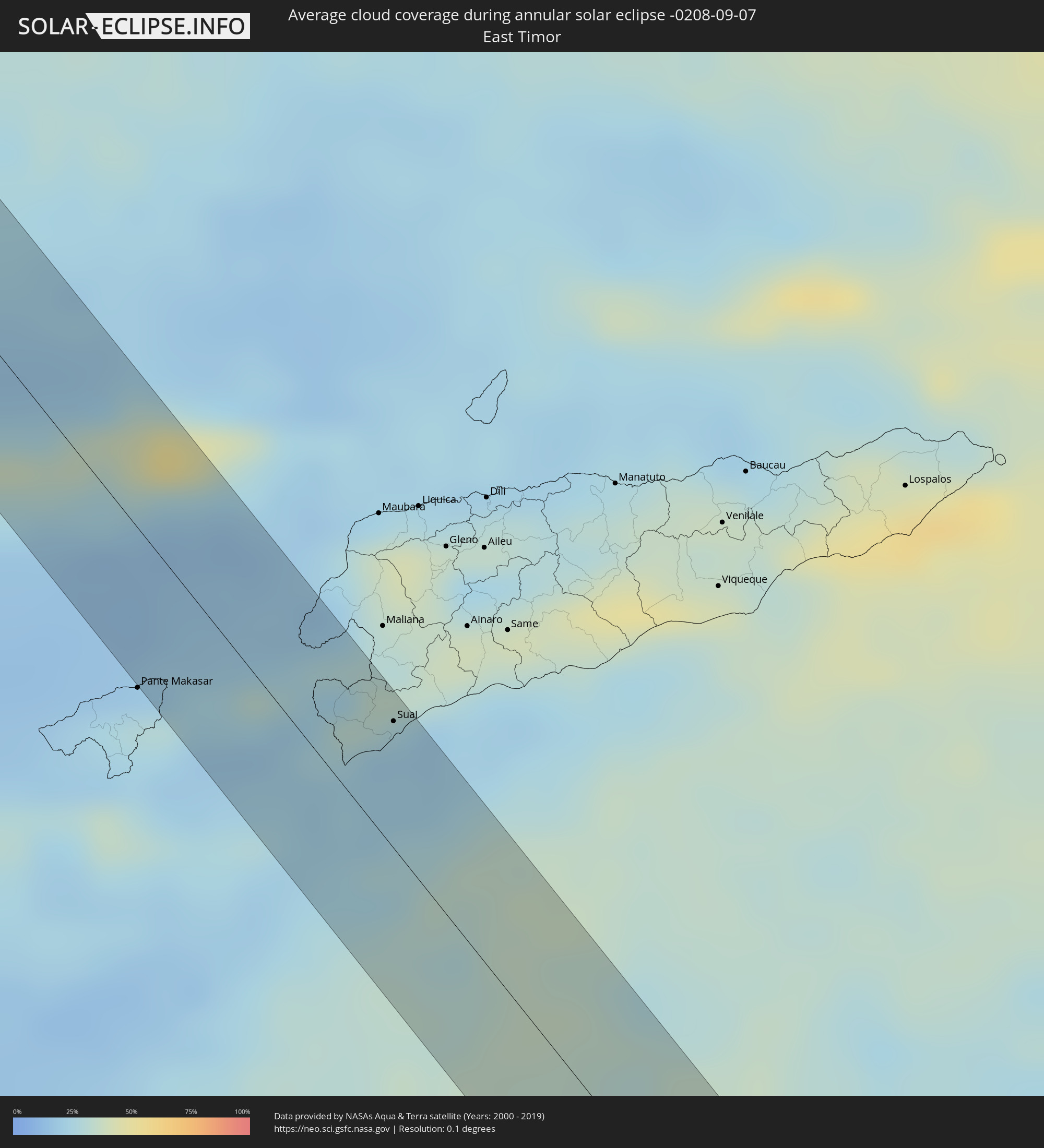 East Timor
Cities inside the path of the eclipse
The following table shows all locations with a population of more than 5,000 inside the eclipse path. Cities which have more than 100,000 inhabitants are marked bold. A click at the locations opens a detailed map.
| City | Type | Eclipse duration | Local time of max. eclipse | Distance to central line | Ø Cloud coverage |
|
Marmagao, Goa
|
annular | - | 07:00:28 UTC+05:21 | 58 km | 84% |
|
Madgaon, Goa
|
annular | - | 07:00:36 UTC+05:21 | 43 km | 86% |
|
Karwar, Karnataka
|
annular | - | 07:00:53 UTC+05:21 | 10 km | 86% |
|
Dandeli, Karnataka
|
annular | - | 07:00:53 UTC+05:21 | 39 km | 91% |
|
Sirsi, Karnataka
|
annular | - | 07:01:17 UTC+05:21 | 34 km | 95% |
|
Hubli, Karnataka
|
annular | - | 07:01:05 UTC+05:21 | 46 km | 91% |
|
Hāveri, Karnataka
|
annular | - | 07:01:28 UTC+05:21 | 17 km | 91% |
|
Rānībennur, Karnataka
|
annular | - | 07:01:40 UTC+05:21 | 37 km | 94% |
|
Gadag, Karnataka
|
annular | - | 07:01:17 UTC+05:21 | 53 km | 92% |
|
Harihar, Karnataka
|
annular | - | 07:01:49 UTC+05:21 | 50 km | 92% |
|
Koppal, Karnataka
|
annular | - | 07:01:35 UTC+05:21 | 42 km | 86% |
|
Hospet, Karnataka
|
annular | - | 07:01:44 UTC+05:21 | 33 km | 83% |
|
Gangāwati, Karnataka
|
annular | - | 07:01:44 UTC+05:21 | 51 km | 87% |
|
Rāyadrug, Andhra Pradesh
|
annular | - | 07:02:16 UTC+05:21 | 31 km | 91% |
|
Bellary, Karnataka
|
annular | - | 07:02:05 UTC+05:21 | 18 km | 88% |
|
Guntakal Junction, Andhra Pradesh
|
annular | - | 07:02:18 UTC+05:21 | 21 km | 91% |
|
Anantapur, Andhra Pradesh
|
annular | - | 07:02:42 UTC+05:21 | 35 km | 91% |
|
Tādpatri, Andhra Pradesh
|
annular | - | 07:02:49 UTC+05:21 | 9 km | 91% |
|
Nandyāl, Andhra Pradesh
|
annular | - | 07:02:48 UTC+05:21 | 55 km | 90% |
|
Proddatūr, Andhra Pradesh
|
annular | - | 07:03:13 UTC+05:21 | 27 km | 91% |
|
Cuddapah, Andhra Pradesh
|
annular | - | 07:03:33 UTC+05:21 | 57 km | 92% |
|
Kandukūr, Andhra Pradesh
|
annular | - | 07:03:50 UTC+05:21 | 27 km | 90% |
|
Nellore, Andhra Pradesh
|
annular | - | 07:04:20 UTC+05:21 | 58 km | 89% |
|
Kāvali, Andhra Pradesh
|
annular | - | 07:04:04 UTC+05:21 | 6 km | 92% |
|
Ongole, Andhra Pradesh
|
annular | - | 07:03:46 UTC+05:21 | 59 km | 91% |
|
Myeik, Tanintharyi
|
annular | - | 08:30:41 UTC+06:24 | 49 km | 93% |
|
Bang Saphan, Prachuap Khiri Khan
|
annular | - | 08:51:01 UTC+06:42 | 46 km | 89% |
|
Prachuap Khiri Khan, Prachuap Khiri Khan
|
annular | - | 08:50:39 UTC+06:42 | 28 km | 87% |
|
Dương Đông, Kiến Giang
|
annular | - | 09:24:45 UTC+07:06 | 46 km | 85% |
|
Cà Mau, Cà Mau
|
annular | - | 09:28:38 UTC+07:06 | 4 km | 95% |
|
Loa Janan, East Kalimantan
|
annular | - | 11:04:29 UTC+07:57 | 33 km | 92% |
|
Samarinda, East Kalimantan
|
annular | - | 11:04:23 UTC+07:57 | 22 km | 93% |
|
Rantepao, South Sulawesi
|
annular | - | 11:16:08 UTC+07:57 | 20 km | 65% |
|
Atambua, East Nusa Tenggara
|
annular | - | 11:40:57 UTC+07:57 | 13 km | 27% |
|
Suai, Cova Lima
|
annular | - | 12:06:53 UTC+08:22 | 30 km | 20% |
|
Muswellbrook, New South Wales
|
annular | - | 14:58:26 UTC+10:00 | 6 km | 54% |
|
Singleton, New South Wales
|
annular | - | 14:58:53 UTC+10:00 | 9 km | 57% |
|
Cessnock, New South Wales
|
annular | - | 14:59:12 UTC+10:00 | 25 km | 56% |
|
Kurri Kurri, New South Wales
|
annular | - | 14:59:19 UTC+10:00 | 18 km | 55% |
|
Rutherford, New South Wales
|
annular | - | 14:59:19 UTC+10:00 | 5 km | 57% |
|
Maitland, New South Wales
|
annular | - | 14:59:20 UTC+10:00 | 6 km | 57% |
|
East Maitland, New South Wales
|
annular | - | 14:59:22 UTC+10:00 | 6 km | 55% |
|
Rathmines, New South Wales
|
annular | - | 14:59:31 UTC+10:00 | 33 km | 52% |
|
Toronto, New South Wales
|
annular | - | 14:59:31 UTC+10:00 | 31 km | 52% |
|
Eleebana, New South Wales
|
annular | - | 14:59:33 UTC+10:00 | 26 km | 52% |
|
Charlestown, New South Wales
|
annular | - | 14:59:33 UTC+10:00 | 21 km | 49% |
|
Belmont North, New South Wales
|
annular | - | 14:59:36 UTC+10:00 | 28 km | 49% |
|
Elermore Vale, New South Wales
|
annular | - | 14:59:33 UTC+10:00 | 17 km | 52% |
|
Mayfield, New South Wales
|
annular | - | 14:59:36 UTC+10:00 | 13 km | 52% |
|
Raymond Terrace, New South Wales
|
annular | - | 14:59:32 UTC+10:00 | 2 km | 53% |
|
Newcastle, New South Wales
|
annular | - | 14:59:39 UTC+10:00 | 13 km | 49% |
|
Medowie, New South Wales
|
annular | - | 14:59:38 UTC+10:00 | 9 km | 53% |
|
Port Stephens, New South Wales
|
annular | - | 14:59:49 UTC+10:00 | 21 km | 51% |
|
Corlette, New South Wales
|
annular | - | 14:59:51 UTC+10:00 | 22 km | 51% |
|
Nelson Bay, New South Wales
|
annular | - | 14:59:53 UTC+10:00 | 24 km | 51% |
|
Porirua, Wellington
|
annular | - | 16:43:54 UTC+11:30 | 50 km | 73% |
|
Petone, Wellington
|
annular | - | 16:43:52 UTC+11:30 | 60 km | 75% |
|
Lower Hutt, Wellington
|
annular | - | 16:43:53 UTC+11:30 | 58 km | 75% |
|
Paraparaumu, Wellington
|
annular | - | 16:43:59 UTC+11:30 | 23 km | 72% |
|
Upper Hutt, Wellington
|
annular | - | 16:43:56 UTC+11:30 | 46 km | 78% |
|
Otaki, Wellington
|
annular | - | 16:44:04 UTC+11:30 | 3 km | 76% |
|
Levin, Manawatu-Wanganui
|
annular | - | 16:44:07 UTC+11:30 | 13 km | 76% |
|
Palmerston North, Manawatu-Wanganui
|
annular | - | 16:44:16 UTC+11:30 | 50 km | 80% |
|
Masterton, Wellington
|
annular | - | 16:44:08 UTC+11:30 | 14 km | 64% |