Annular solar eclipse of 02/16/-0504
| Day of week: | Friday |
| Maximum duration of eclipse: | 03m59s |
| Maximum width of eclipse path: | 197 km |
| Saros cycle: | 61 |
| Coverage: | 96.2% |
| Magnitude: | 0.9616 |
| Gamma: | 0.7261 |
Wo kann man die Sonnenfinsternis vom 02/16/-0504 sehen?
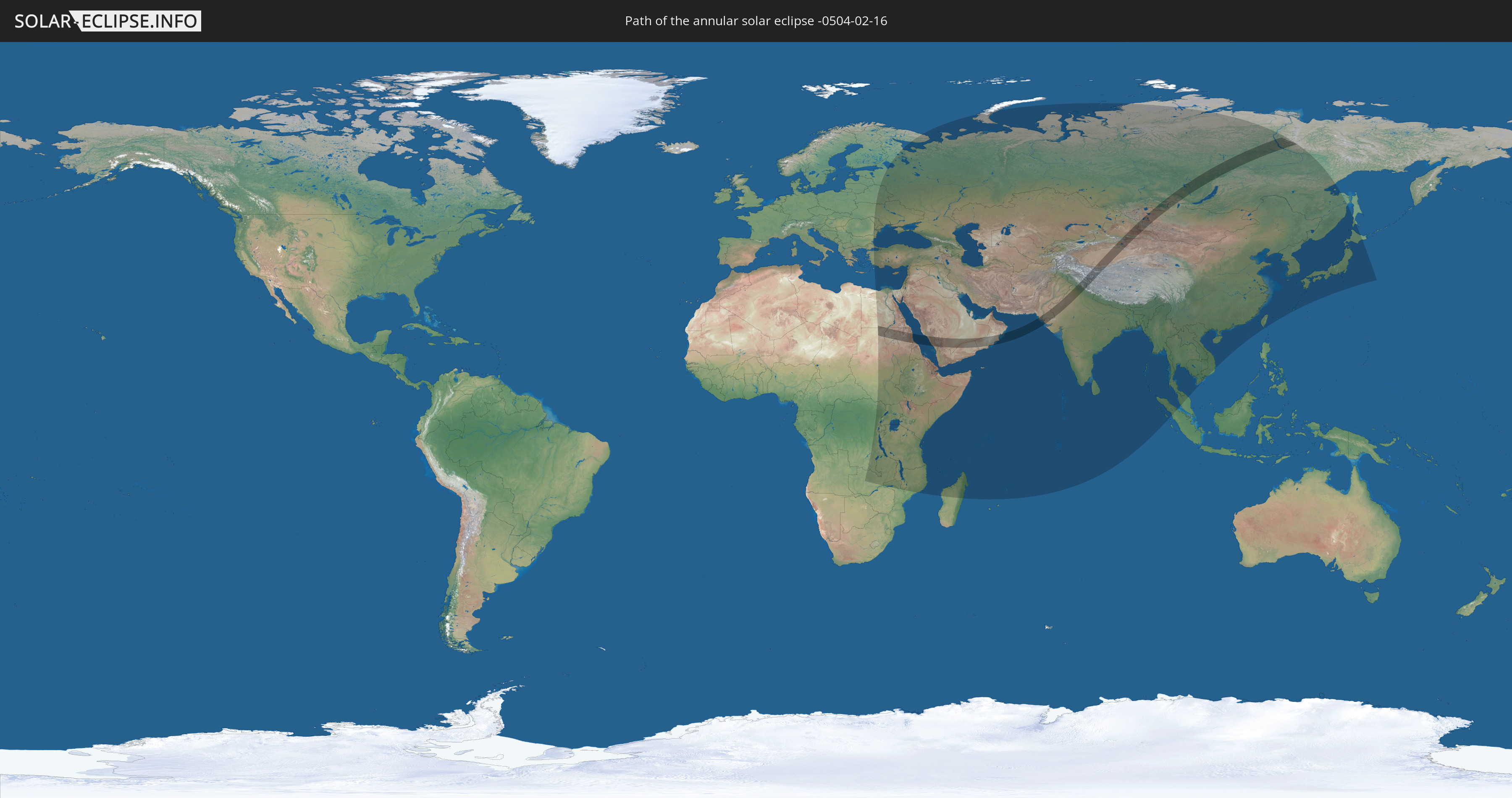
Die Sonnenfinsternis am 02/16/-0504 kann man in 76 Ländern als partielle Sonnenfinsternis beobachten.
Der Finsternispfad verläuft durch 10 Länder. Nur in diesen Ländern ist sie als annular Sonnenfinsternis zu sehen.
In den folgenden Ländern ist die Sonnenfinsternis annular zu sehen
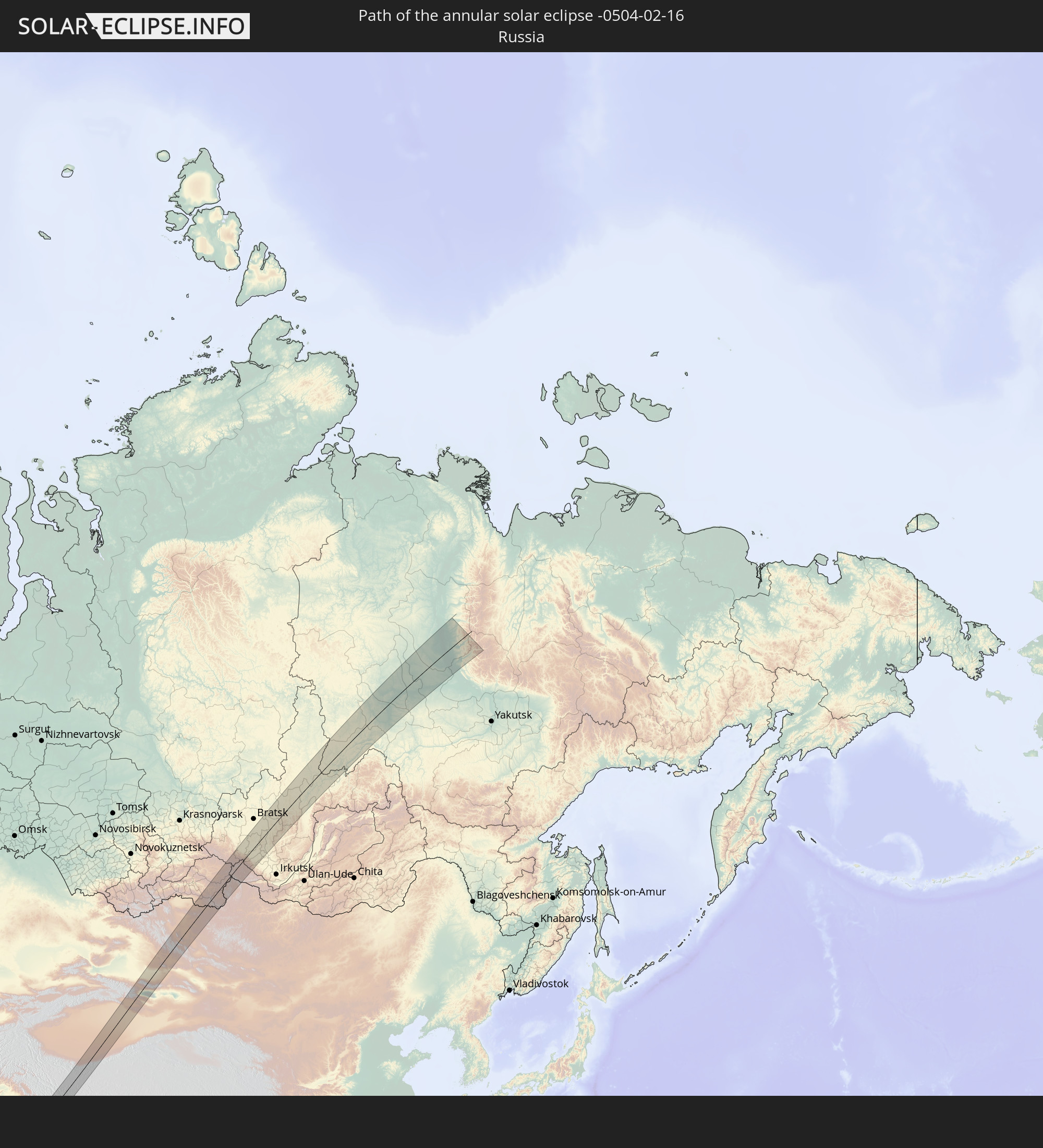 Russia
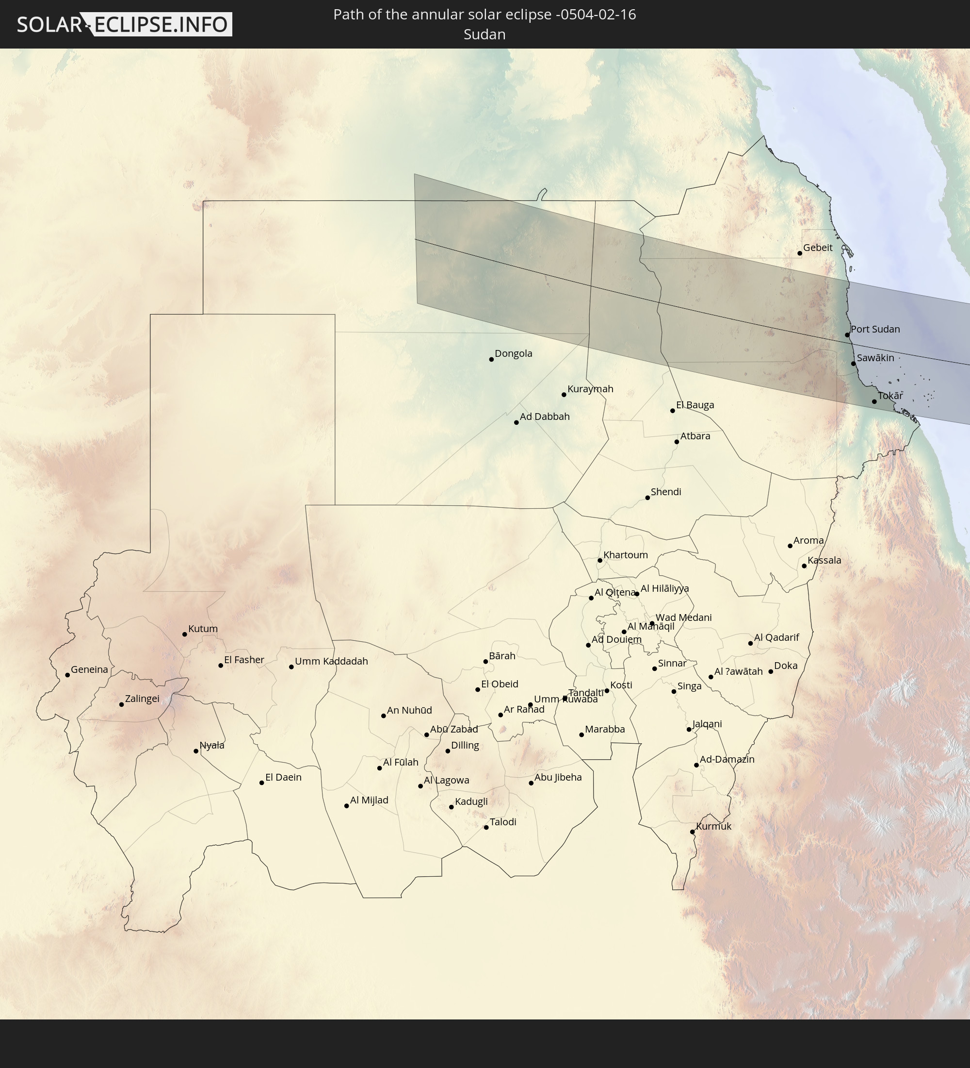 Sudan
Sudan
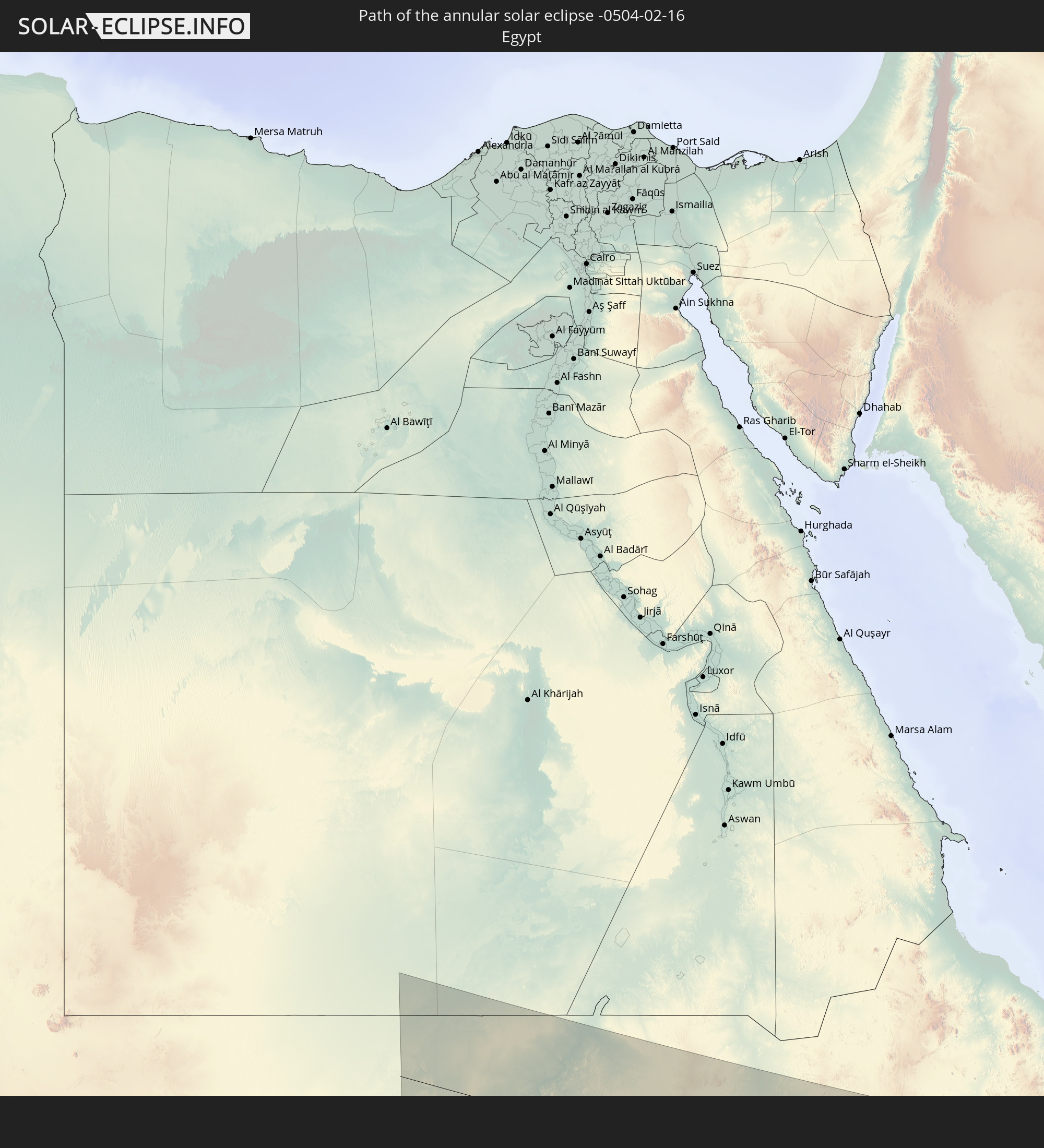 Egypt
Egypt
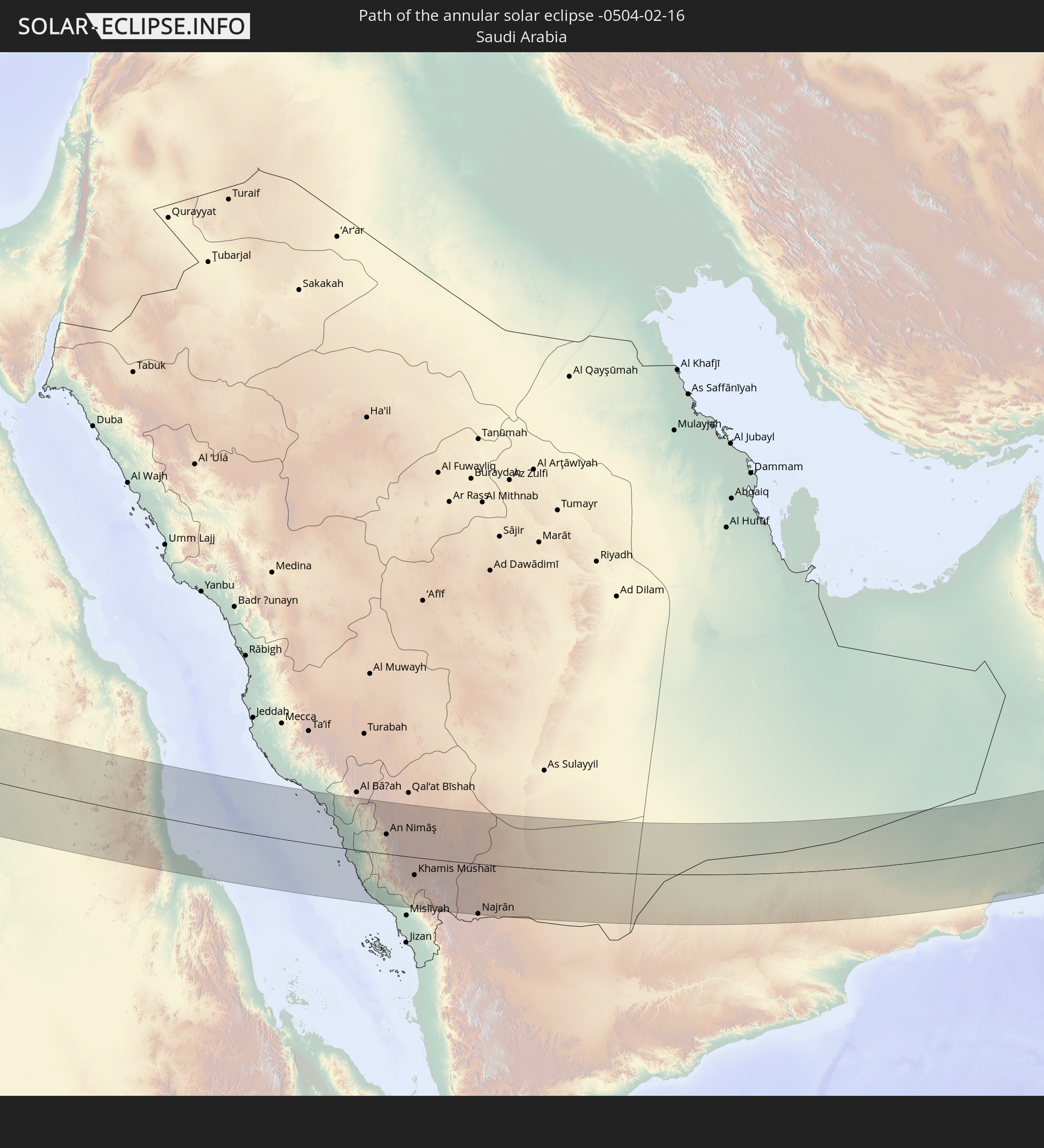 Saudi Arabia
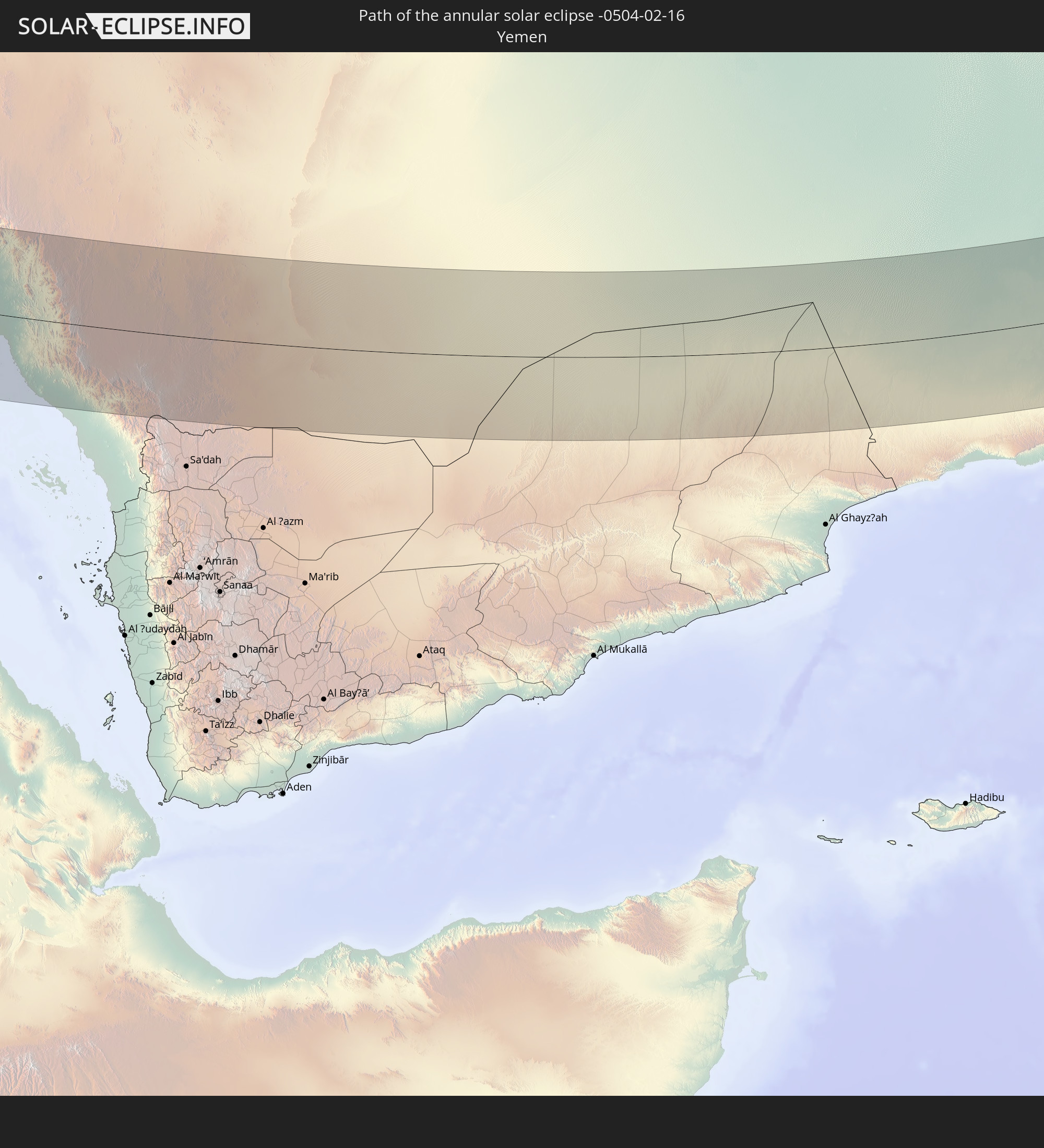 Yemen
Yemen
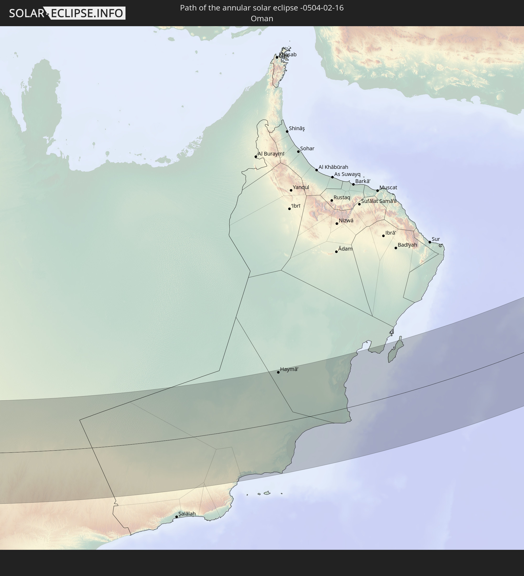 Oman
Oman
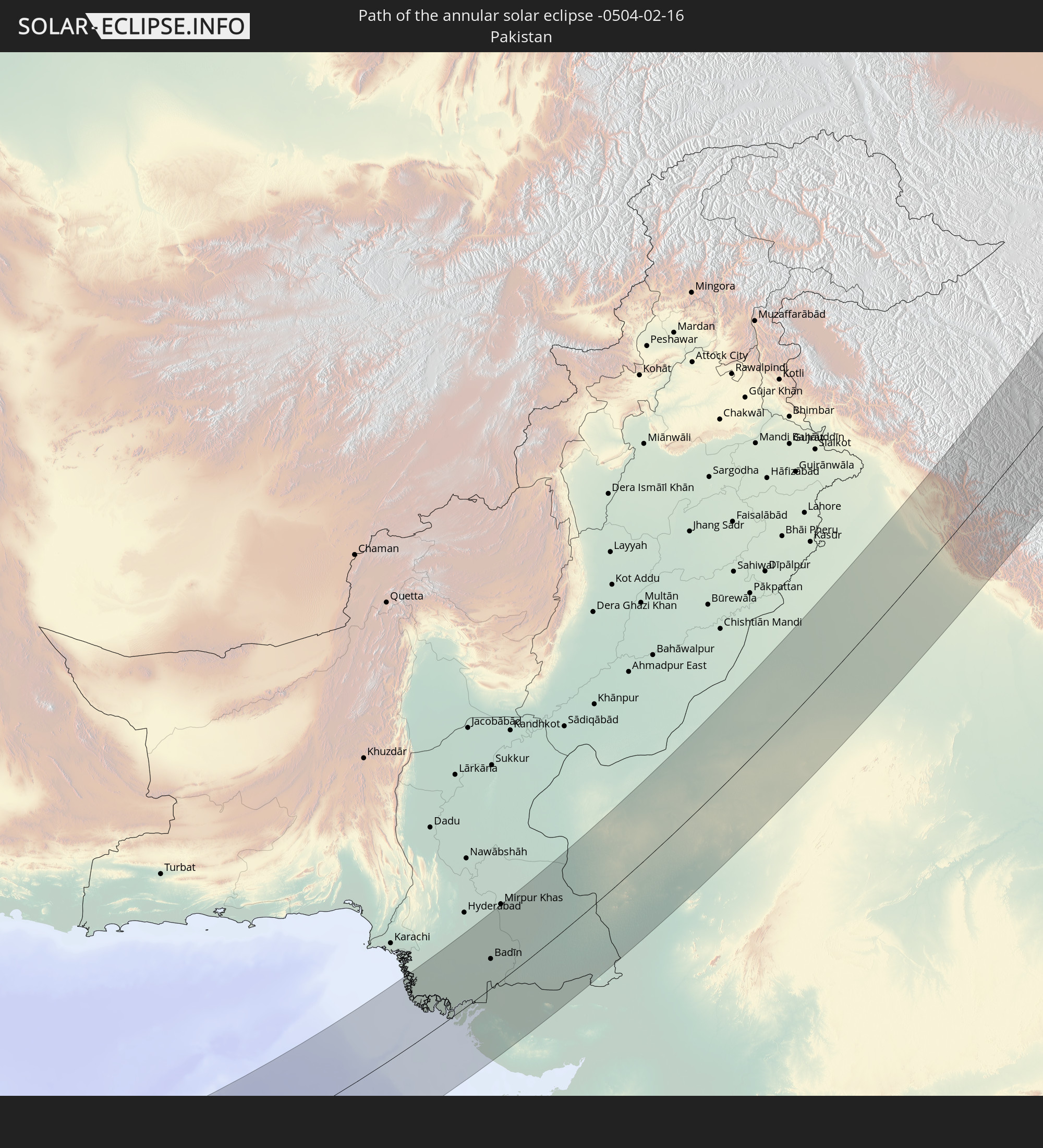 Pakistan
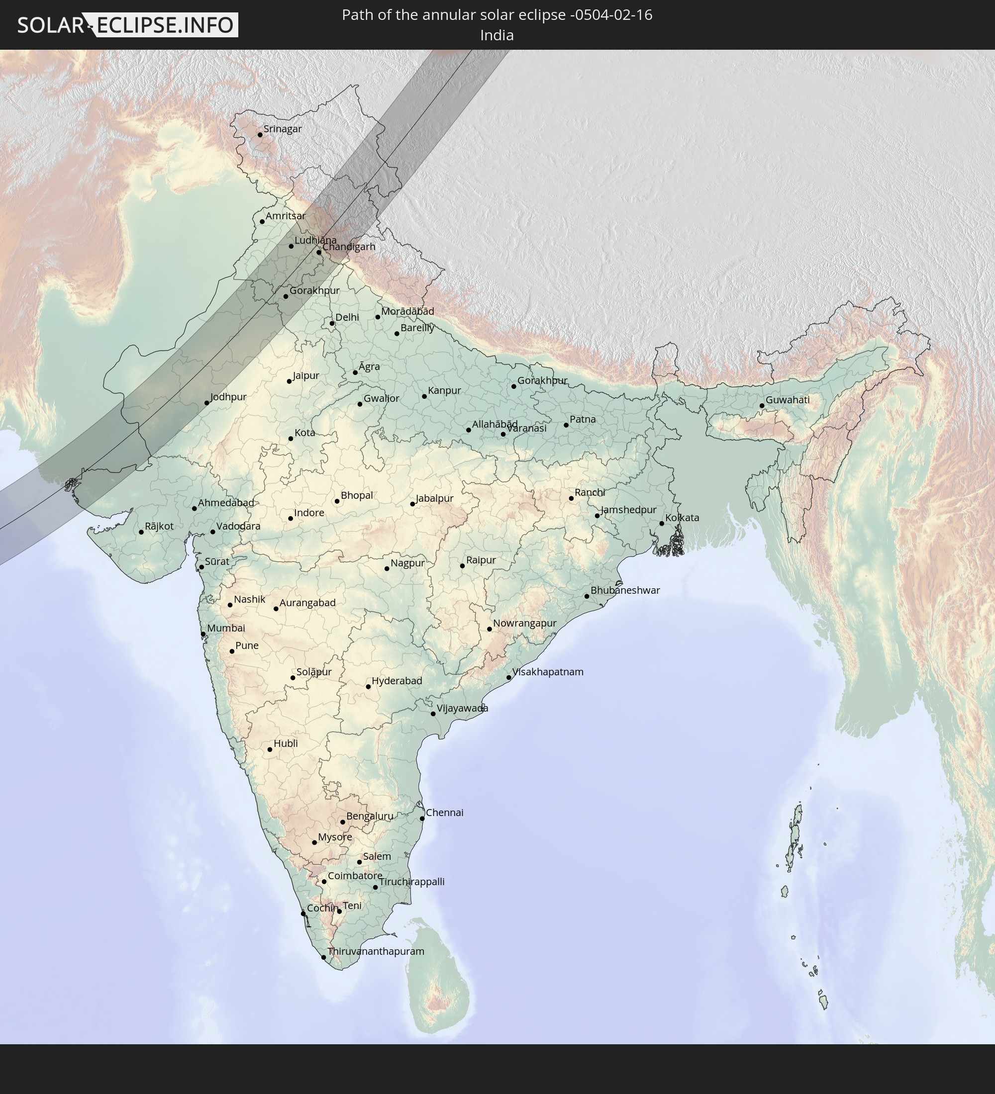 India
India
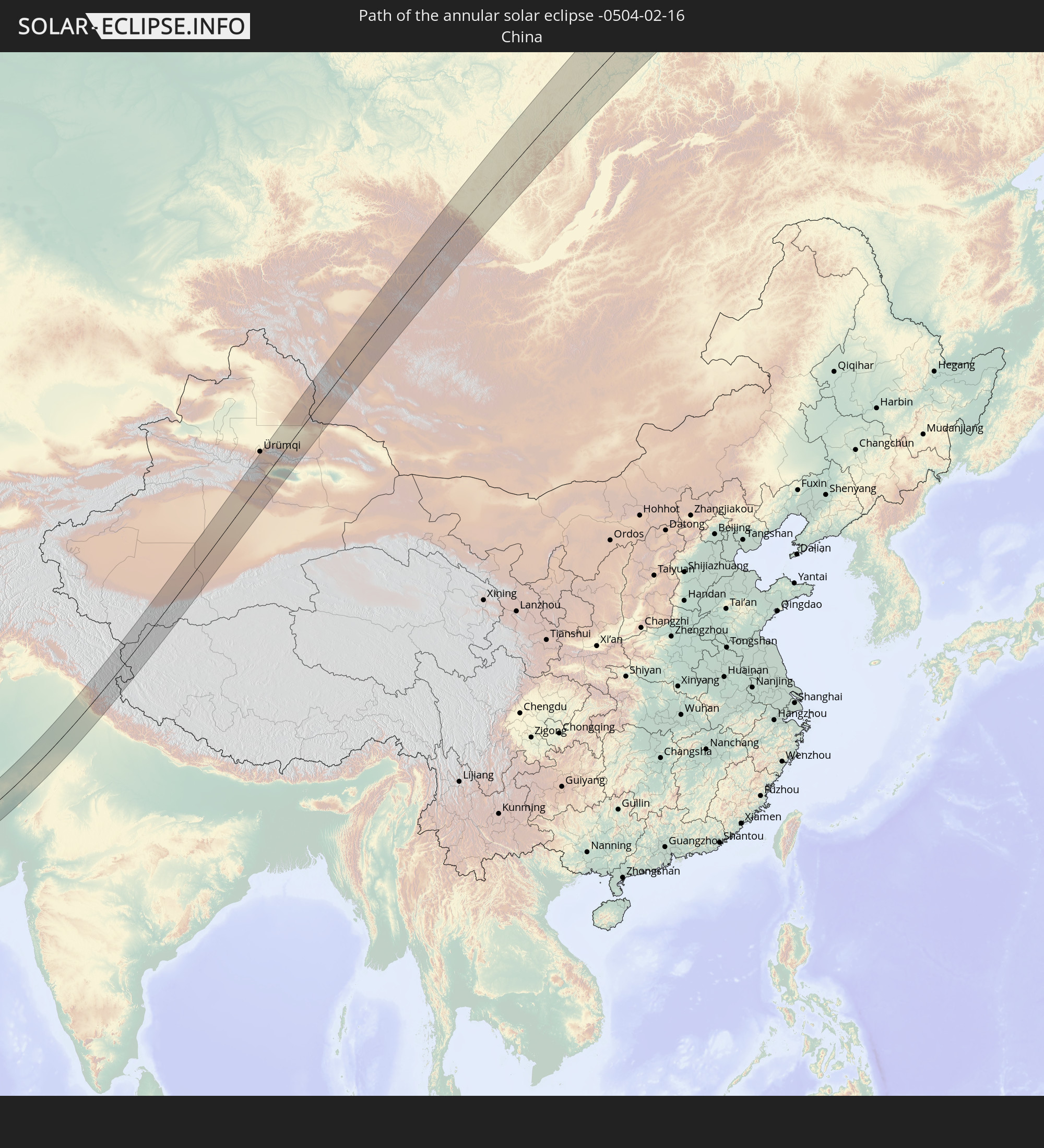 China
China
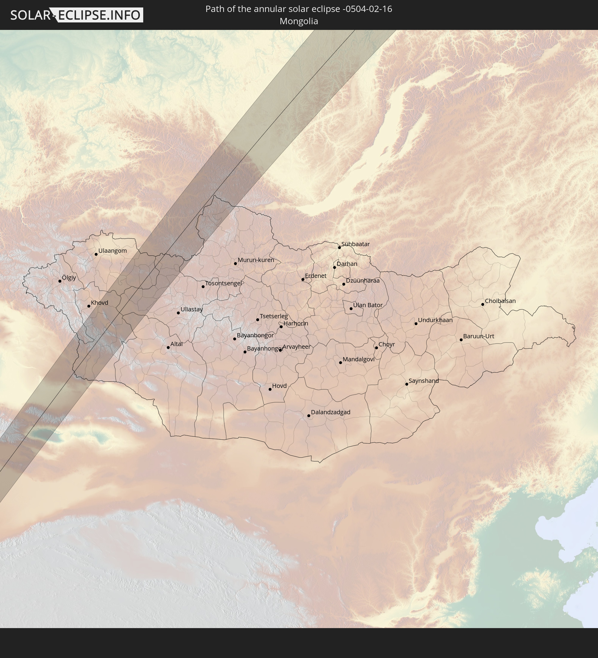 Mongolia
In den folgenden Ländern ist die Sonnenfinsternis partiell zu sehen
 Russia
 Democratic Republic of the Congo
 Greece
 Romania
 Sudan
Sudan
 Zambia
 Ukraine
 Bulgaria
 Belarus
 Egypt
Egypt
 Turkey
 Moldova
 Rwanda
 Burundi
 Tanzania
 Uganda
 Mozambique
 Cyprus
 Malawi
 Ethiopia
 Kenya
Kenya
 State of Palestine
 Israel
 Saudi Arabia
 Jordan
 Lebanon
 Syria
Syria
 Eritrea
 Iraq
Iraq
 Georgia
 French Southern and Antarctic Lands
 Somalia
 Djibouti
 Yemen
Yemen
 Madagascar
 Comoros
 Armenia
 Iran
Iran
 Azerbaijan
 Mayotte
 Seychelles
 Kazakhstan
 Kuwait
 Bahrain
 Qatar
Qatar
 United Arab Emirates
 Oman
Oman
 Turkmenistan
 Uzbekistan
 Mauritius
 Afghanistan
 Pakistan
 Tajikistan
 India
India
 Kyrgyzstan
 British Indian Ocean Territory
 Maldives
 China
China
 Sri Lanka
 Nepal
Nepal
 Mongolia
 Bangladesh
 Bhutan
 Myanmar
 Indonesia
 Thailand
 Malaysia
 Laos
Laos
 Vietnam
 Cambodia
 Macau
Macau
 Hong Kong
 Taiwan
 Japan
Japan
 North Korea
 South Korea
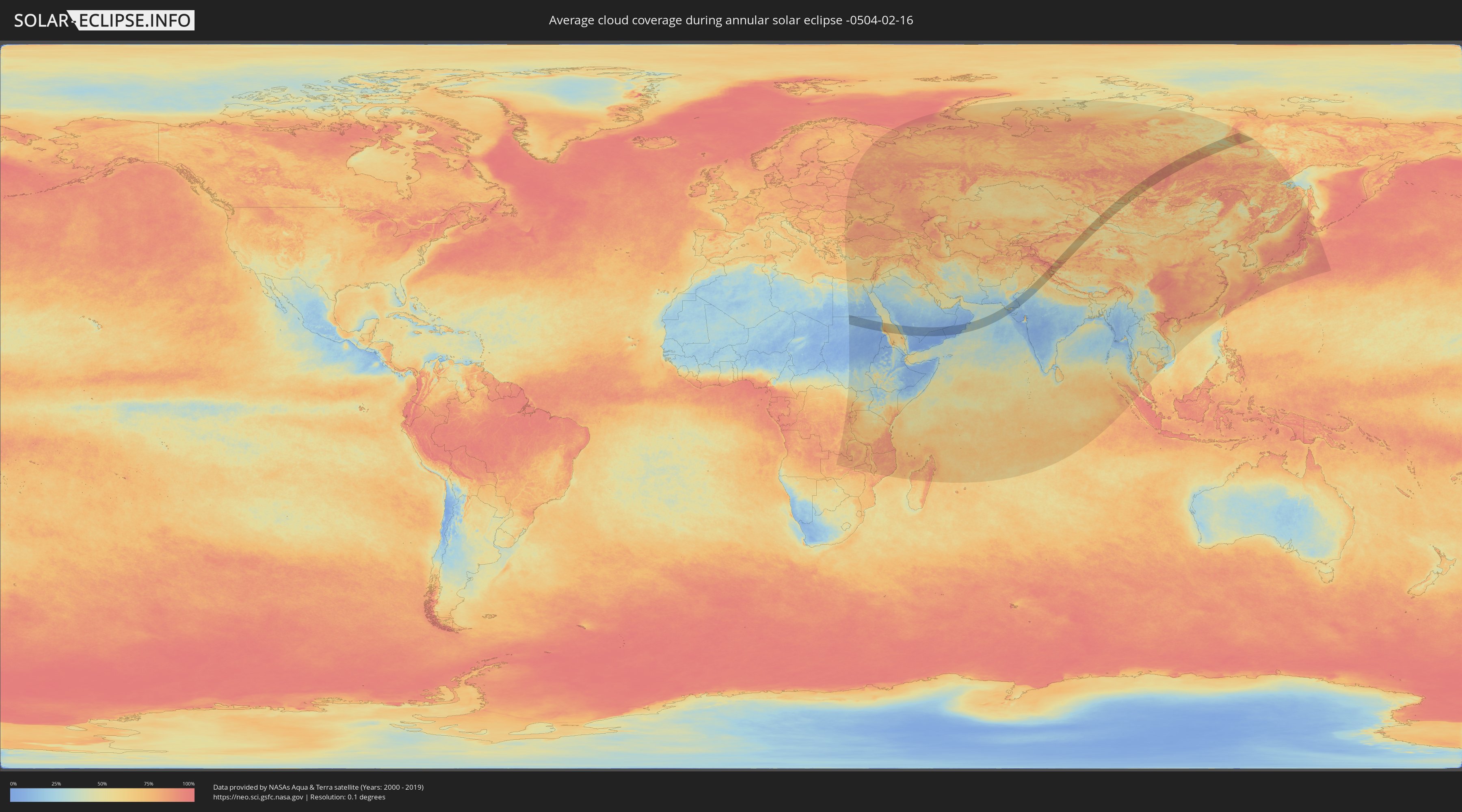
How will be the weather during the annular solar eclipse on 02/16/-0504?
Where is the best place to see the annular solar eclipse of 02/16/-0504?
The following maps show the average cloud coverage for the day of the annular solar eclipse.
With the help of these maps, it is possible to find the place along the eclipse path, which has the best
chance of a cloudless sky.
Nevertheless, you should consider local circumstances and inform about the weather of your chosen
observation site.
The data is provided by NASAs satellites
AQUA and TERRA.
The cloud maps are averaged over a period of 19 years (2000 - 2019).

Detailed country maps
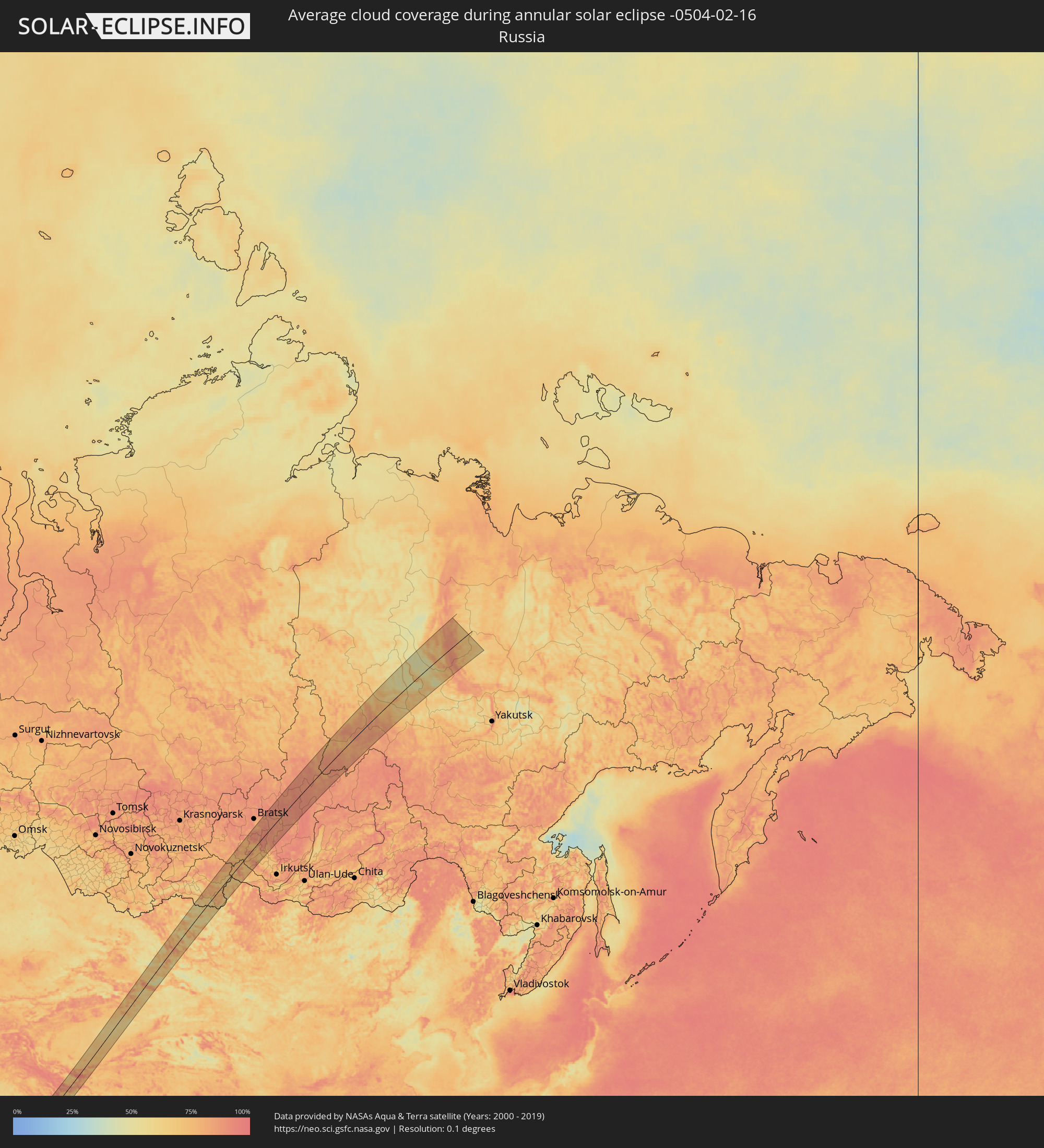 Russia
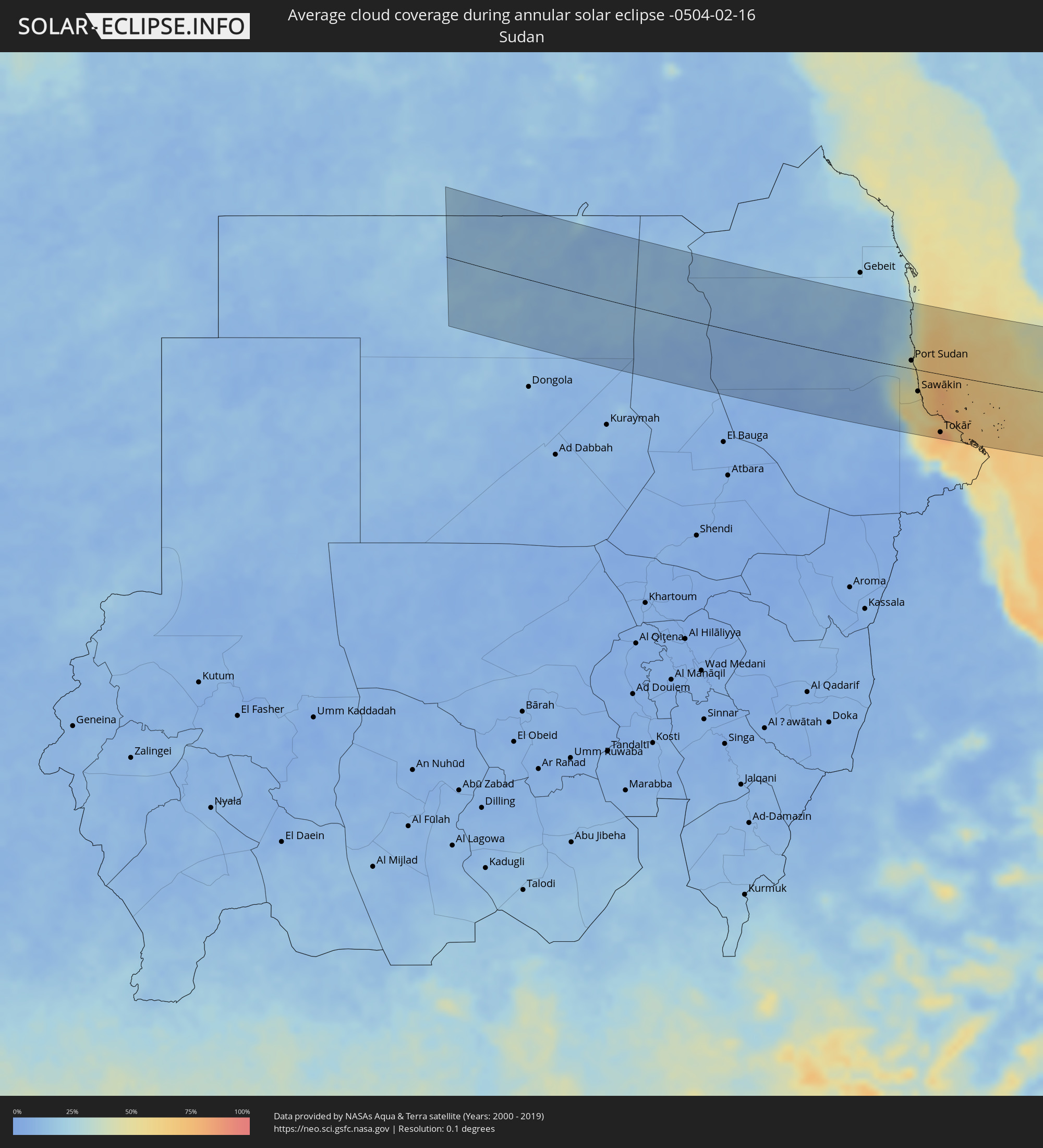 Sudan
Sudan
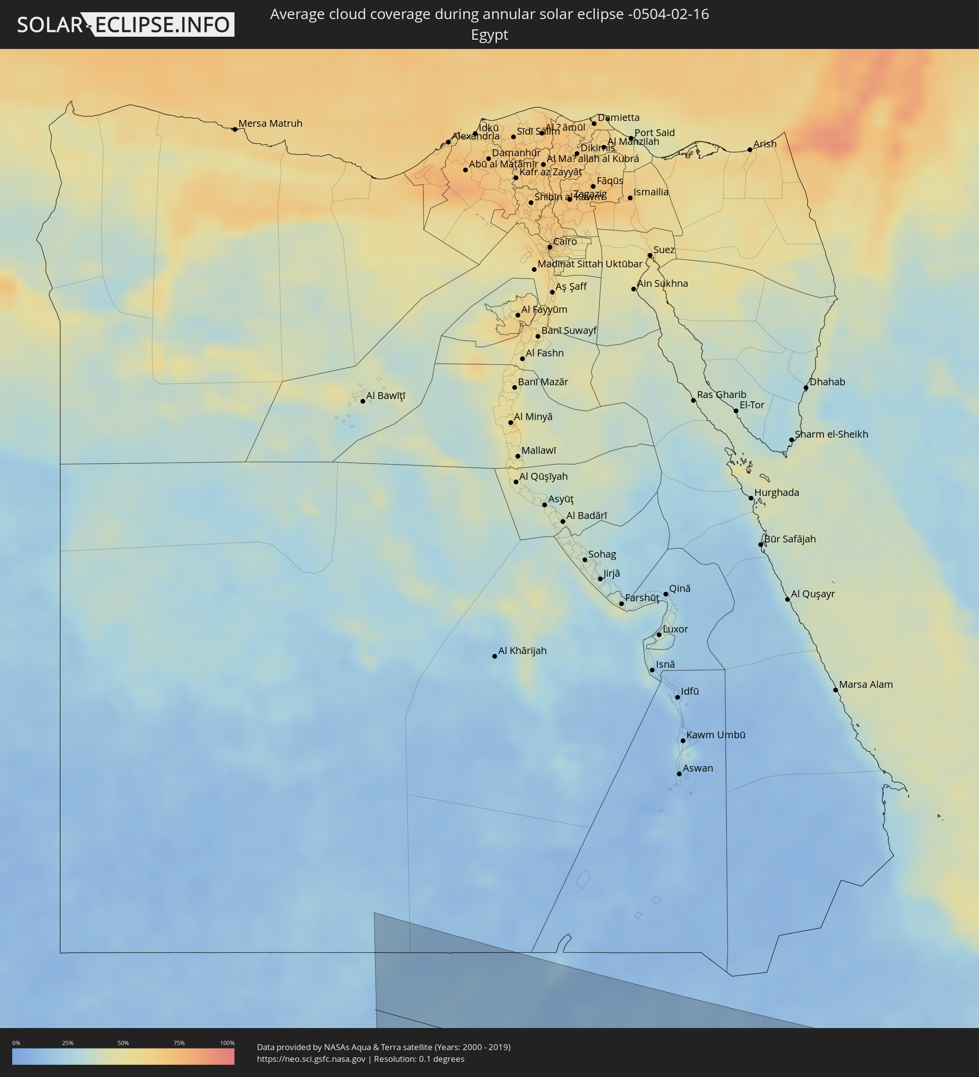 Egypt
Egypt
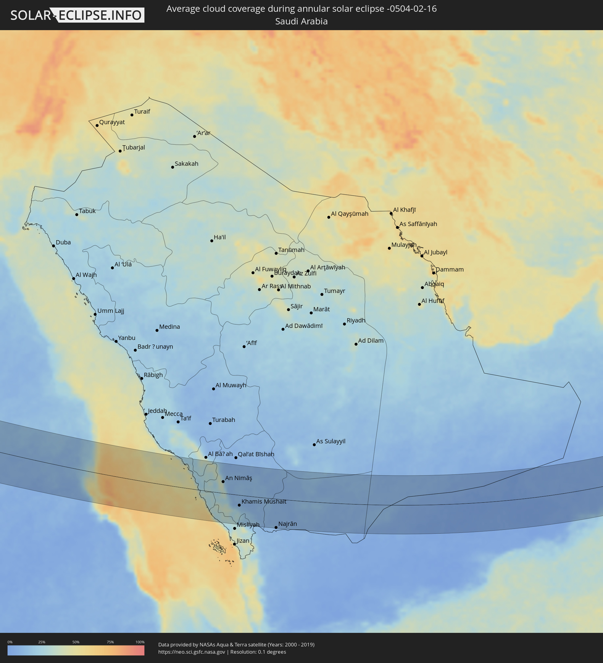 Saudi Arabia
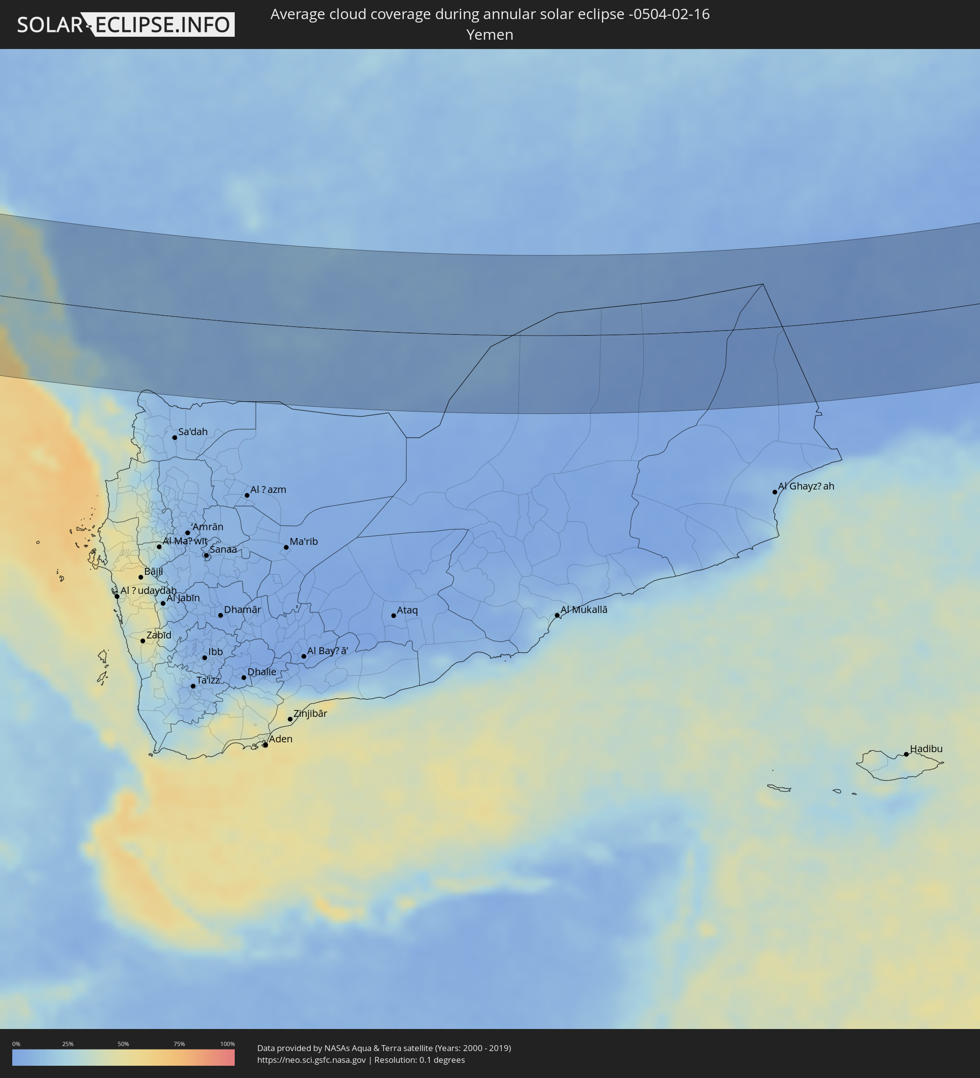 Yemen
Yemen
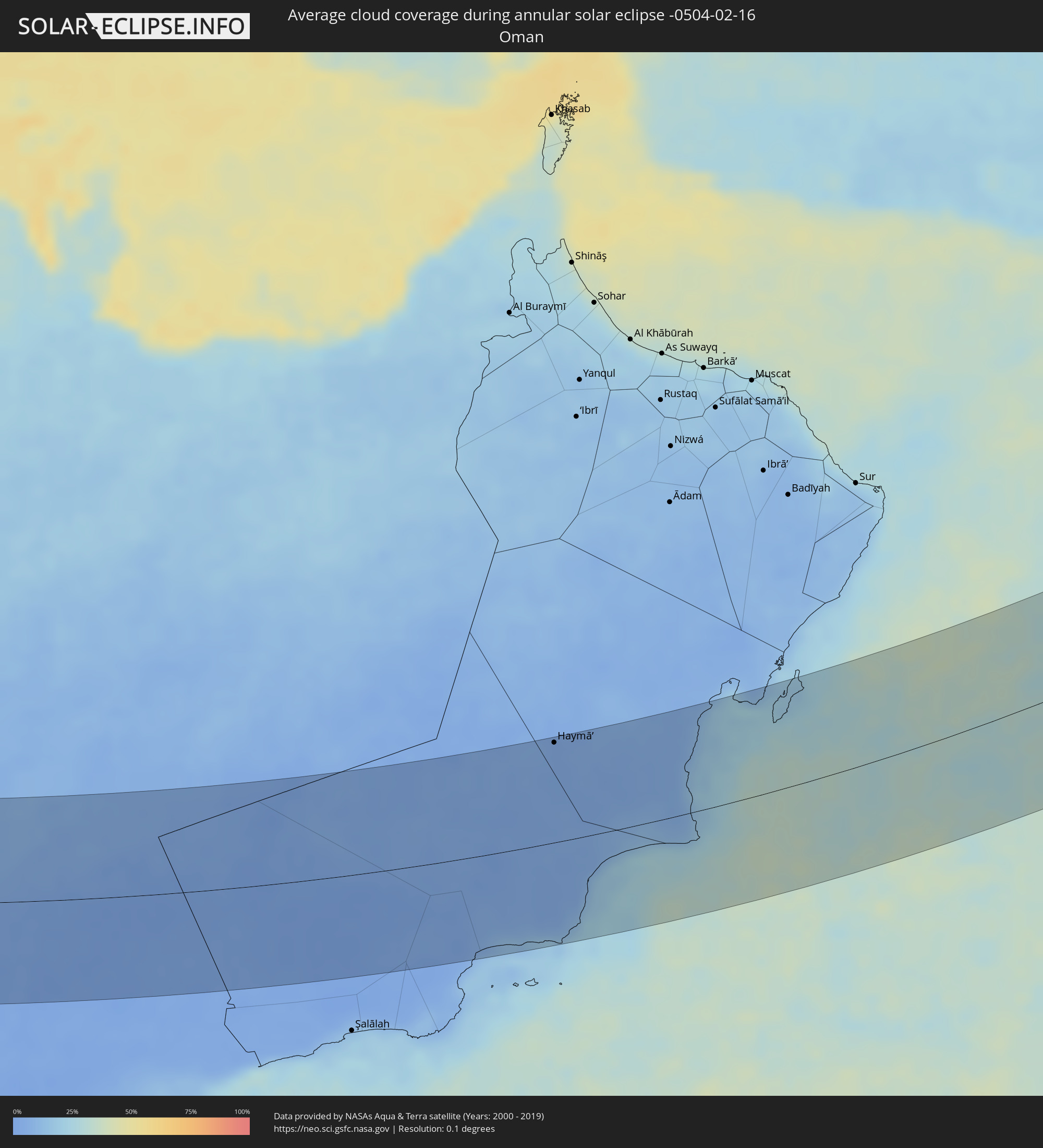 Oman
Oman
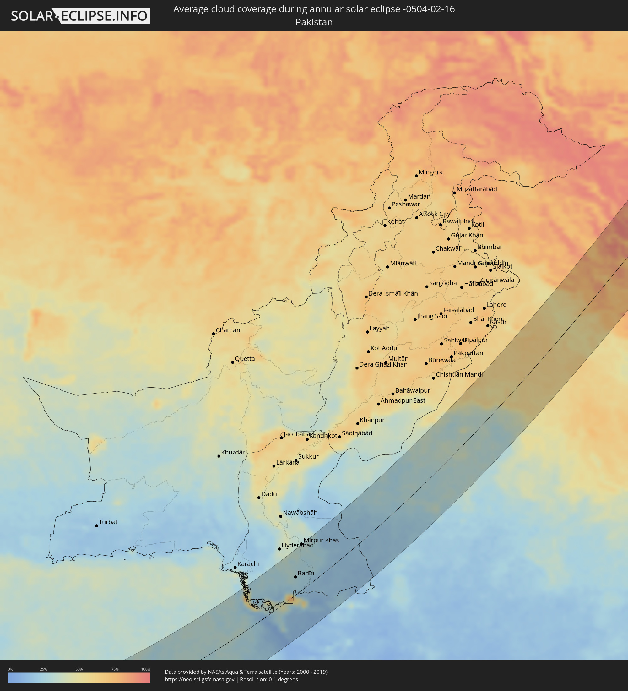 Pakistan
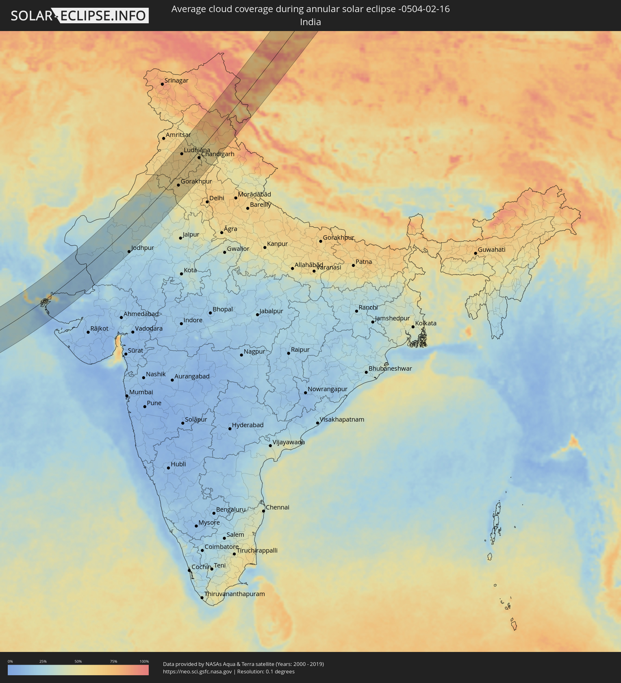 India
India
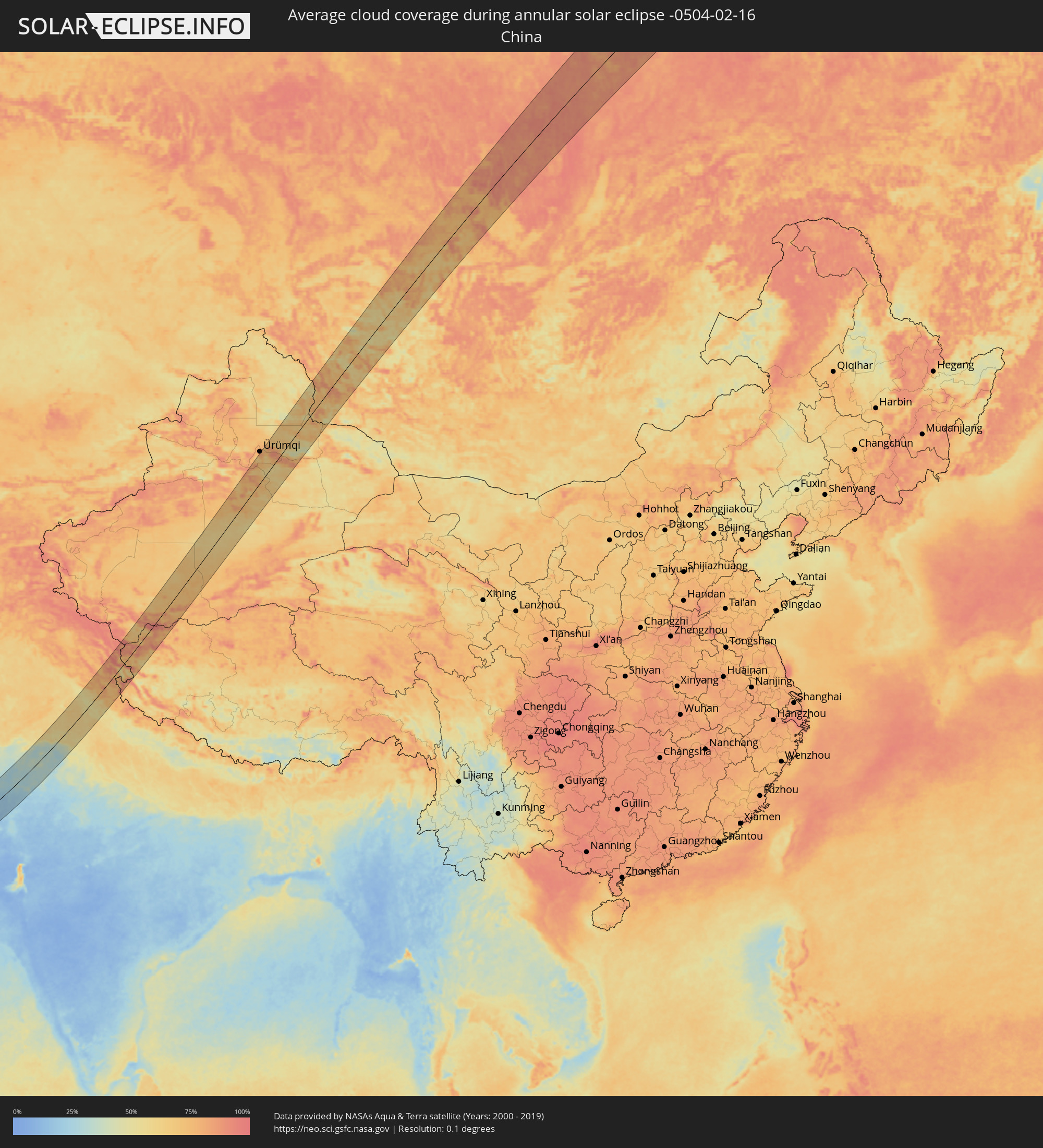 China
China
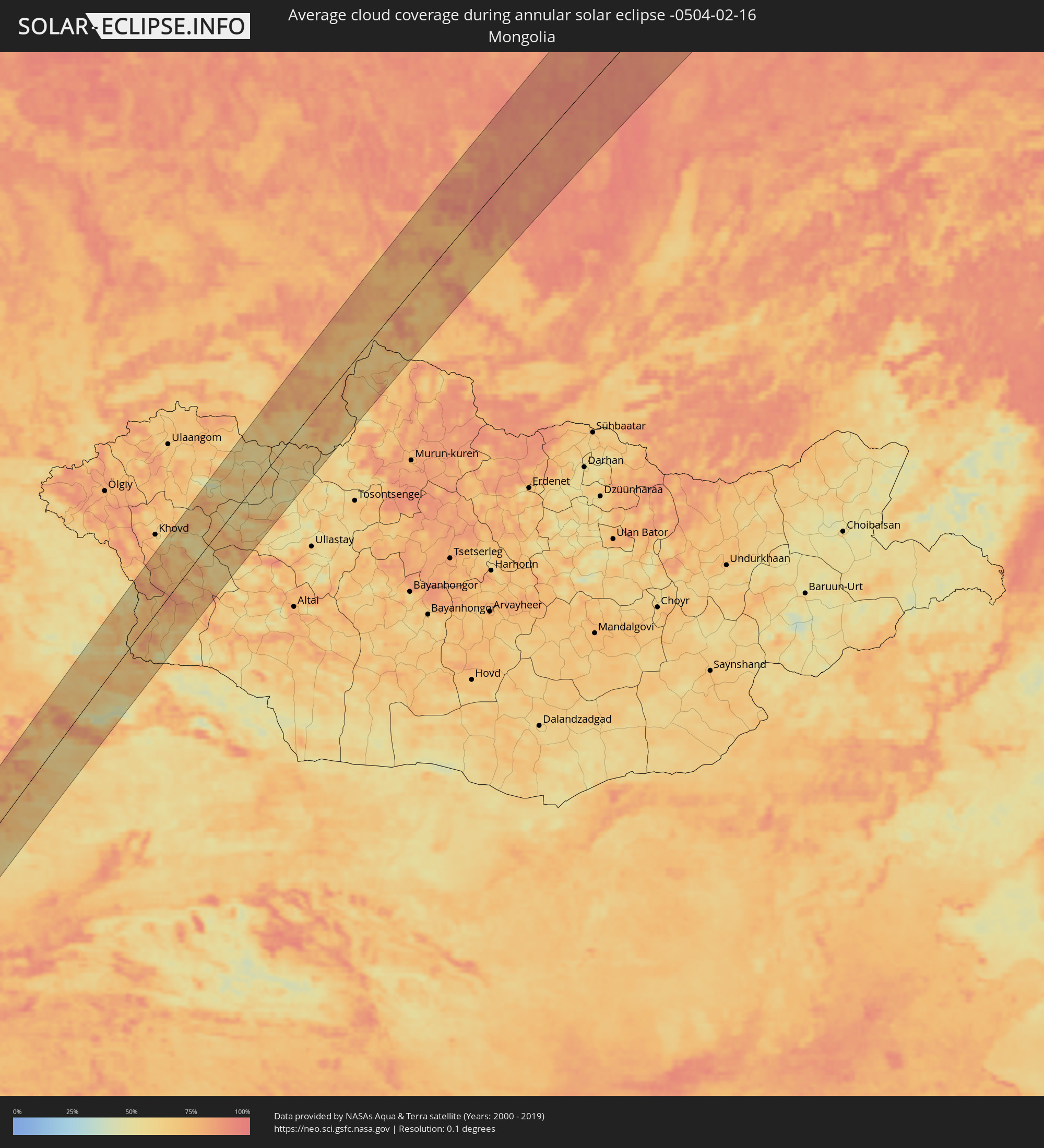 Mongolia
Cities inside the path of the eclipse
The following table shows all locations with a population of more than 5,000 inside the eclipse path. Cities which have more than 100,000 inhabitants are marked bold. A click at the locations opens a detailed map.
| City | Type | Eclipse duration | Local time of max. eclipse | Distance to central line | Ø Cloud coverage |
|
Port Sudan, Red Sea
|
annular | - | 06:57:38 UTC+02:10 | 14 km | 37% |
|
Sawākin, Red Sea
|
annular | - | 06:56:59 UTC+02:10 | 39 km | 48% |
|
Tokār, Red Sea
|
annular | - | 06:56:18 UTC+02:10 | 106 km | 76% |
|
Al Majāridah, 'Asir
|
annular | - | 07:57:31 UTC+03:06 | 39 km | 27% |
|
An Nimāş, 'Asir
|
annular | - | 07:57:45 UTC+03:06 | 45 km | 37% |
|
Ad Darb, Jizan
|
annular | - | 07:55:45 UTC+03:06 | 111 km | 26% |
|
Abha, 'Asir
|
annular | - | 07:56:43 UTC+03:06 | 53 km | 28% |
|
Khamis Mushait, 'Asir
|
annular | - | 07:57:04 UTC+03:06 | 41 km | 13% |
|
Najrān, Najran
|
annular | - | 07:57:16 UTC+03:06 | 115 km | 9% |
|
Haymā’, Al Wusţá
|
annular | - | 08:52:50 UTC+03:41 | 111 km | 3% |
|
Mīrpur Sakro, Sindh
|
annular | - | 10:11:59 UTC+04:28 | 105 km | 26% |
|
Thatta, Sindh
|
annular | - | 10:13:02 UTC+04:28 | 106 km | 29% |
|
Chuhar Jamāli, Sindh
|
annular | - | 10:12:29 UTC+04:28 | 69 km | 23% |
|
Dāro Mehar, Sindh
|
annular | - | 10:13:42 UTC+04:28 | 94 km | 25% |
|
Mīrpur Batoro, Sindh
|
annular | - | 10:13:45 UTC+04:28 | 83 km | 26% |
|
Jāti, Sindh
|
annular | - | 10:13:02 UTC+04:28 | 50 km | 22% |
|
Tando Muhammad Khān, Sindh
|
annular | - | 10:15:09 UTC+04:28 | 101 km | 30% |
|
Mātli, Sindh
|
annular | - | 10:15:16 UTC+04:28 | 87 km | 29% |
|
Chambar, Sindh
|
annular | - | 10:16:06 UTC+04:28 | 99 km | 32% |
|
Talhār, Sindh
|
annular | - | 10:15:19 UTC+04:28 | 63 km | 30% |
|
Badīn, Sindh
|
annular | - | 10:14:55 UTC+04:28 | 41 km | 29% |
|
Rājo Khanāni, Sindh
|
annular | - | 10:15:36 UTC+04:28 | 69 km | 27% |
|
Tando Ghulām Ali, Sindh
|
annular | - | 10:15:55 UTC+04:28 | 81 km | 28% |
|
Tando Bāgo, Sindh
|
annular | - | 10:15:28 UTC+04:28 | 45 km | 28% |
|
Kadhan, Sindh
|
annular | - | 10:14:55 UTC+04:28 | 17 km | 24% |
|
Mirpur Khas, Sindh
|
partial | - | 10:17:01 UTC+04:28 | 106 km | 30% |
|
Mīrwāh Gorchani, Sindh
|
annular | - | 10:16:41 UTC+04:28 | 85 km | 26% |
|
Digri, Sindh
|
annular | - | 10:16:31 UTC+04:28 | 68 km | 27% |
|
Pithoro, Sindh
|
annular | - | 10:17:48 UTC+04:28 | 82 km | 26% |
|
Samaro, Sindh
|
annular | - | 10:17:24 UTC+04:28 | 61 km | 28% |
|
Naukot, Sindh
|
annular | - | 10:16:36 UTC+04:28 | 24 km | 25% |
|
Kunri, Sindh
|
annular | - | 10:17:36 UTC+04:28 | 41 km | 26% |
|
Dhoro Naro, Sindh
|
annular | - | 10:18:14 UTC+04:28 | 69 km | 26% |
|
Diplo, Sindh
|
annular | - | 10:16:14 UTC+04:28 | 22 km | 18% |
|
Nabīsar, Sindh
|
annular | - | 10:17:33 UTC+04:28 | 27 km | 25% |
|
Umarkot, Sindh
|
annular | - | 10:18:20 UTC+04:28 | 46 km | 25% |
|
Chor, Sindh
|
annular | - | 10:18:42 UTC+04:28 | 57 km | 22% |
|
Mithi, Sindh
|
annular | - | 10:17:15 UTC+04:28 | 12 km | 16% |
|
Islāmkot, Sindh
|
annular | - | 10:18:03 UTC+04:28 | 39 km | 17% |
|
Bārmer, Rajasthan
|
annular | - | 11:15:48 UTC+05:21 | 30 km | 18% |
|
Jodhpur, Rajasthan
|
annular | - | 11:20:28 UTC+05:21 | 96 km | 26% |
|
Bīkaner, Rajasthan
|
annular | - | 11:24:26 UTC+05:21 | 21 km | 34% |
|
Nāgaur, Rajasthan
|
annular | - | 11:23:52 UTC+05:21 | 72 km | 30% |
|
Hanumāngarh, Rajasthan
|
annular | - | 11:29:31 UTC+05:21 | 69 km | 56% |
|
Sūjāngarh, Rajasthan
|
annular | - | 11:26:26 UTC+05:21 | 85 km | 31% |
|
Sardārshahr, Rajasthan
|
annular | - | 11:27:50 UTC+05:21 | 29 km | 31% |
|
Bhatinda, Punjab
|
annular | - | 11:31:58 UTC+05:21 | 71 km | 60% |
|
Fatehpur, Rajasthan
|
annular | - | 11:28:04 UTC+05:21 | 97 km | 30% |
|
Chūru, Rajasthan
|
annular | - | 11:28:39 UTC+05:21 | 74 km | 29% |
|
Sirsa, Haryana
|
annular | - | 11:30:59 UTC+05:21 | 15 km | 56% |
|
Mānsa, Punjab
|
annular | - | 11:32:36 UTC+05:21 | 22 km | 60% |
|
Barnāla, Punjab
|
annular | - | 11:33:36 UTC+05:21 | 40 km | 62% |
|
Gorakhpur, Haryana
|
annular | - | 11:32:15 UTC+05:21 | 38 km | 55% |
|
Hisar, Haryana
|
annular | - | 11:31:51 UTC+05:21 | 64 km | 59% |
|
Phagwāra, Punjab
|
annular | - | 11:35:32 UTC+05:21 | 85 km | 61% |
|
Sangrūr, Punjab
|
annular | - | 11:34:01 UTC+05:21 | 9 km | 60% |
|
Ludhiāna, Punjab
|
annular | - | 11:35:11 UTC+05:21 | 57 km | 64% |
|
Māler Kotla, Punjab
|
annular | - | 11:34:35 UTC+05:21 | 27 km | 61% |
|
Hānsi, Haryana
|
annular | - | 11:32:17 UTC+05:21 | 85 km | 55% |
|
Khanna, Punjab
|
annular | - | 11:35:38 UTC+05:21 | 15 km | 64% |
|
Jīnd, Haryana
|
annular | - | 11:33:26 UTC+05:21 | 94 km | 57% |
|
Patiāla, Punjab
|
annular | - | 11:35:22 UTC+05:21 | 24 km | 60% |
|
Kaithal, Haryana
|
annular | - | 11:34:28 UTC+05:21 | 64 km | 60% |
|
Rājpura, Punjab
|
annular | - | 11:36:03 UTC+05:21 | 28 km | 57% |
|
Chandigarh, Chandigarh
|
annular | - | 11:36:54 UTC+05:21 | 24 km | 59% |
|
Ambāla, Haryana
|
annular | - | 11:36:18 UTC+05:21 | 52 km | 59% |
|
Thānesar, Haryana
|
annular | - | 11:35:42 UTC+05:21 | 83 km | 58% |
|
Shimla, Himachal Pradesh
|
annular | - | 11:38:20 UTC+05:21 | 25 km | 54% |
|
Korla, Xinjiang Uyghur Autonomous Region
|
annular | - | 14:48:17 UTC+08:00 | 58 km | 75% |
|
Sishilichengzi, Xinjiang Uyghur Autonomous Region
|
annular | - | 14:49:01 UTC+08:00 | 49 km | 77% |
|
Turpan, Xinjiang Uyghur Autonomous Region
|
annular | - | 14:54:12 UTC+08:00 | 63 km | 66% |
|
Tulun, Irkutsk
|
annular | - | 14:09:15 UTC+06:57 | 79 km | 77% |
|
Kuytun, Irkutsk
|
annular | - | 14:10:14 UTC+06:57 | 17 km | 73% |
|
Zima, Irkutsk
|
annular | - | 14:10:50 UTC+06:57 | 40 km | 76% |
|
Sayansk, Irkutsk
|
annular | - | 14:10:56 UTC+06:57 | 32 km | 82% |
|
Zalari, Irkutsk
|
annular | - | 14:11:22 UTC+06:57 | 89 km | 74% |
|
Ust’-Uda, Irkutsk
|
annular | - | 14:11:47 UTC+06:57 | 70 km | 76% |
|
Novaya Igirma, Irkutsk
|
annular | - | 14:11:47 UTC+06:57 | 104 km | 90% |
|
Zheleznogorsk-Ilimskiy, Irkutsk
|
annular | - | 14:12:10 UTC+06:57 | 53 km | 86% |
|
Ust’-Kut, Irkutsk
|
annular | - | 14:13:33 UTC+06:57 | 6 km | 92% |
|
Markovo, Irkutsk
|
annular | - | 14:14:27 UTC+06:57 | 26 km | 90% |
|
Kirensk, Irkutsk
|
annular | - | 14:15:05 UTC+06:57 | 36 km | 91% |
|
Mirny, Sakha
|
annular | - | 15:58:07 UTC+08:38 | 94 km | 81% |
|
Lensk, Sakha
|
annular | - | 16:00:05 UTC+08:38 | 85 km | 83% |
|
Suntar, Sakha
|
annular | - | 16:00:36 UTC+08:38 | 70 km | 81% |
|
Nyurba, Sakha
|
annular | - | 16:00:01 UTC+08:38 | 2 km | 81% |
|
Verkhnevilyuysk, Sakha
|
annular | - | 16:00:53 UTC+08:38 | 55 km | 71% |
|
Vilyuysk, Sakha
|
annular | - | 16:01:16 UTC+08:38 | 74 km | 68% |