Total solar eclipse of 07/03/-0921
| Day of week: | Tuesday |
| Maximum duration of eclipse: | 05m15s |
| Maximum width of eclipse path: | 180 km |
| Saros cycle: | 41 |
| Coverage: | 100% |
| Magnitude: | 1.0534 |
| Gamma: | -0.1939 |
Wo kann man die Sonnenfinsternis vom 07/03/-0921 sehen?

Die Sonnenfinsternis am 07/03/-0921 kann man in 50 Ländern als partielle Sonnenfinsternis beobachten.
Der Finsternispfad verläuft durch 6 Länder. Nur in diesen Ländern ist sie als total Sonnenfinsternis zu sehen.
In den folgenden Ländern ist die Sonnenfinsternis total zu sehen
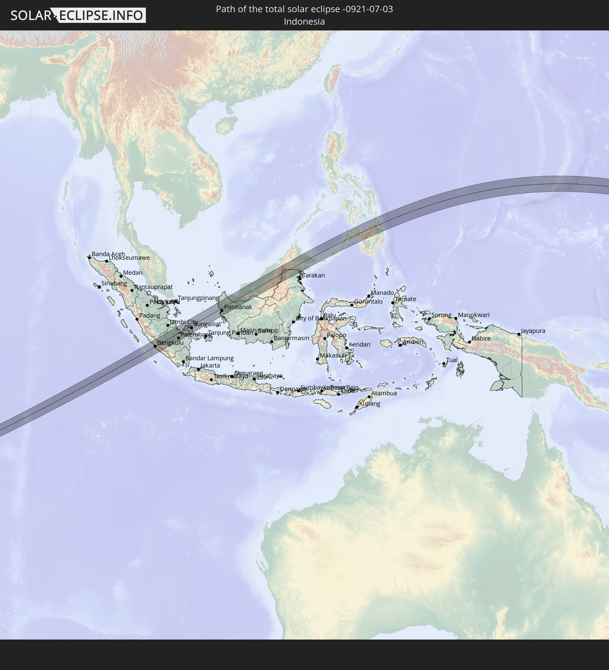 Indonesia
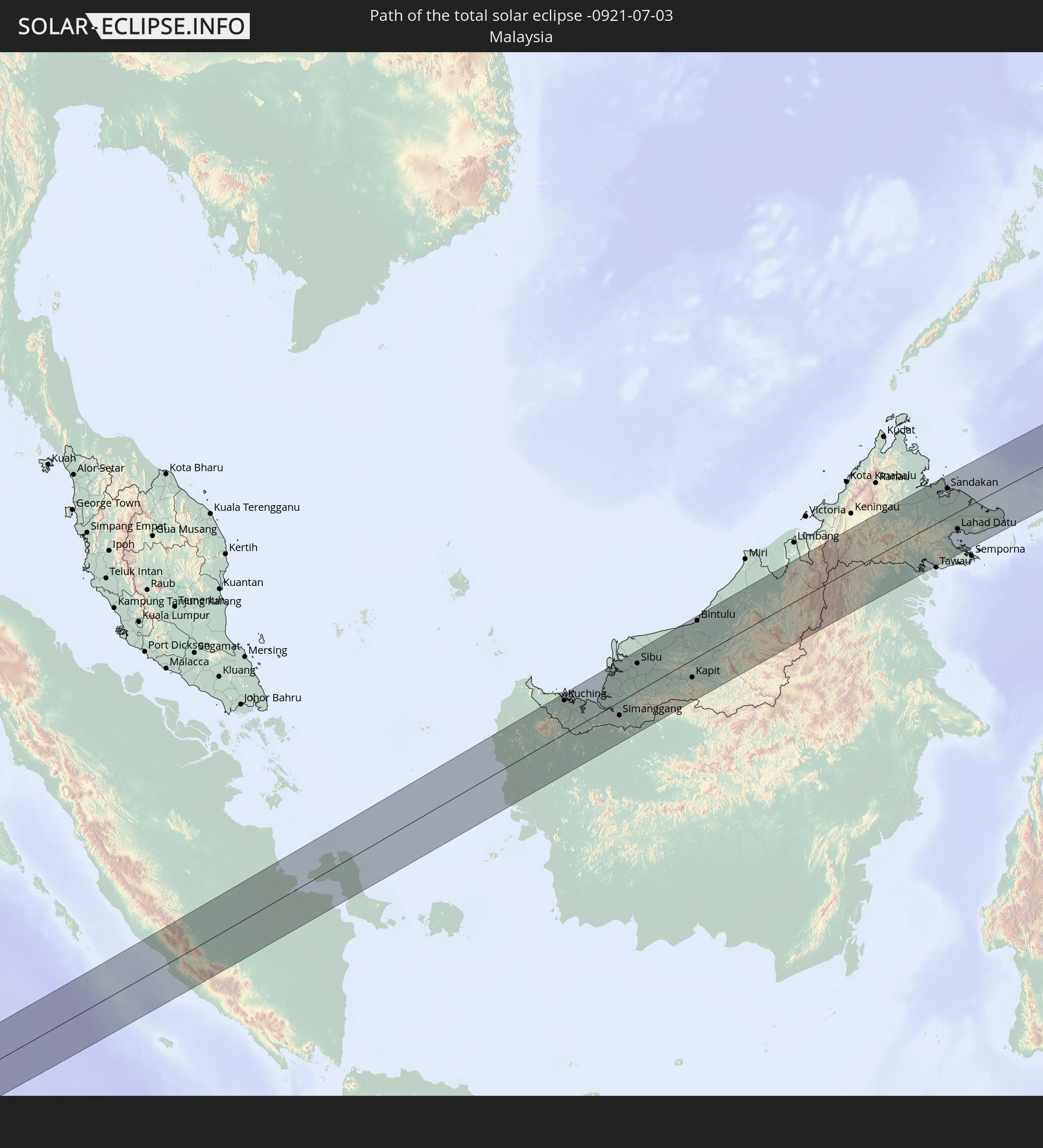 Malaysia
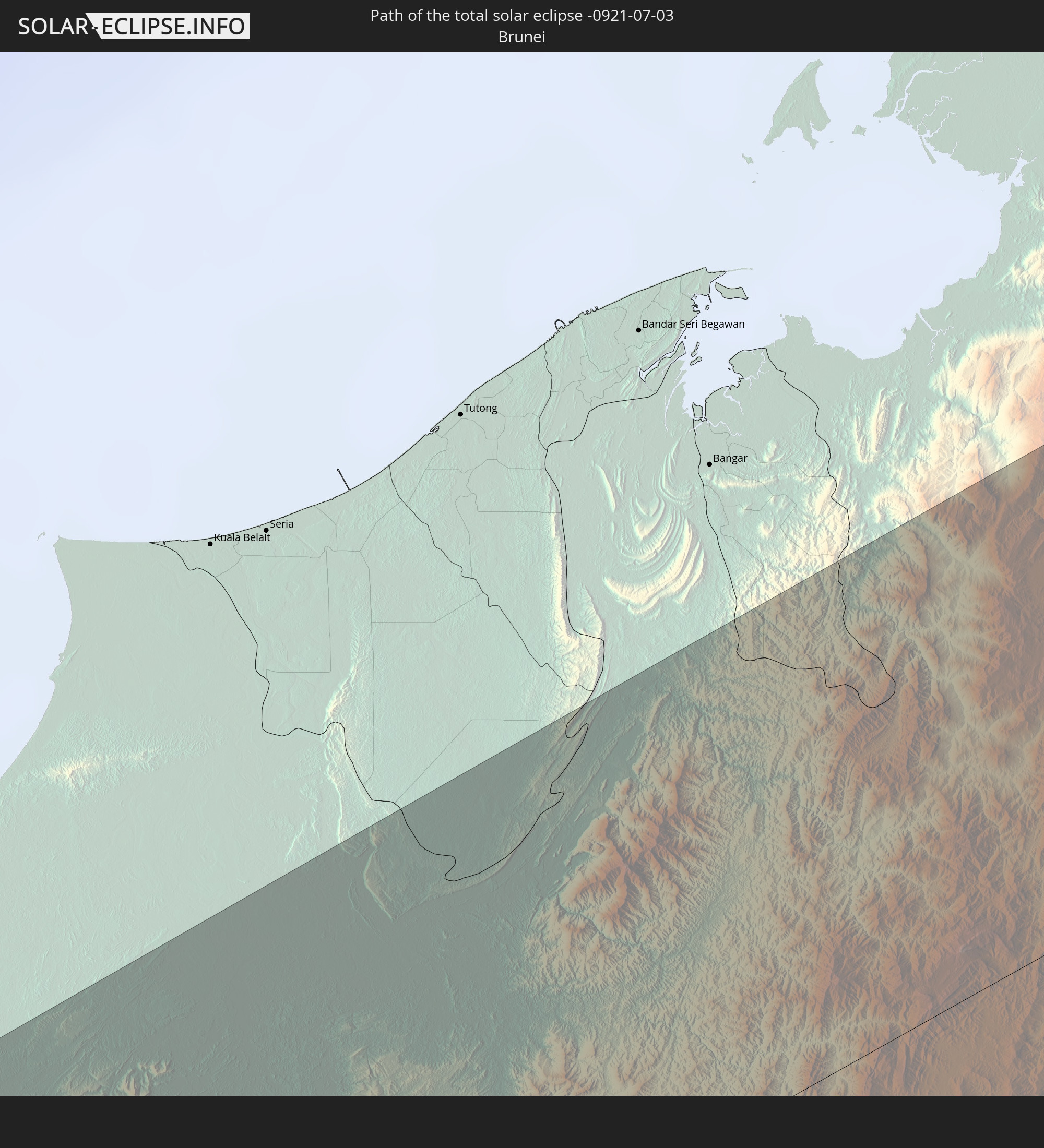 Brunei
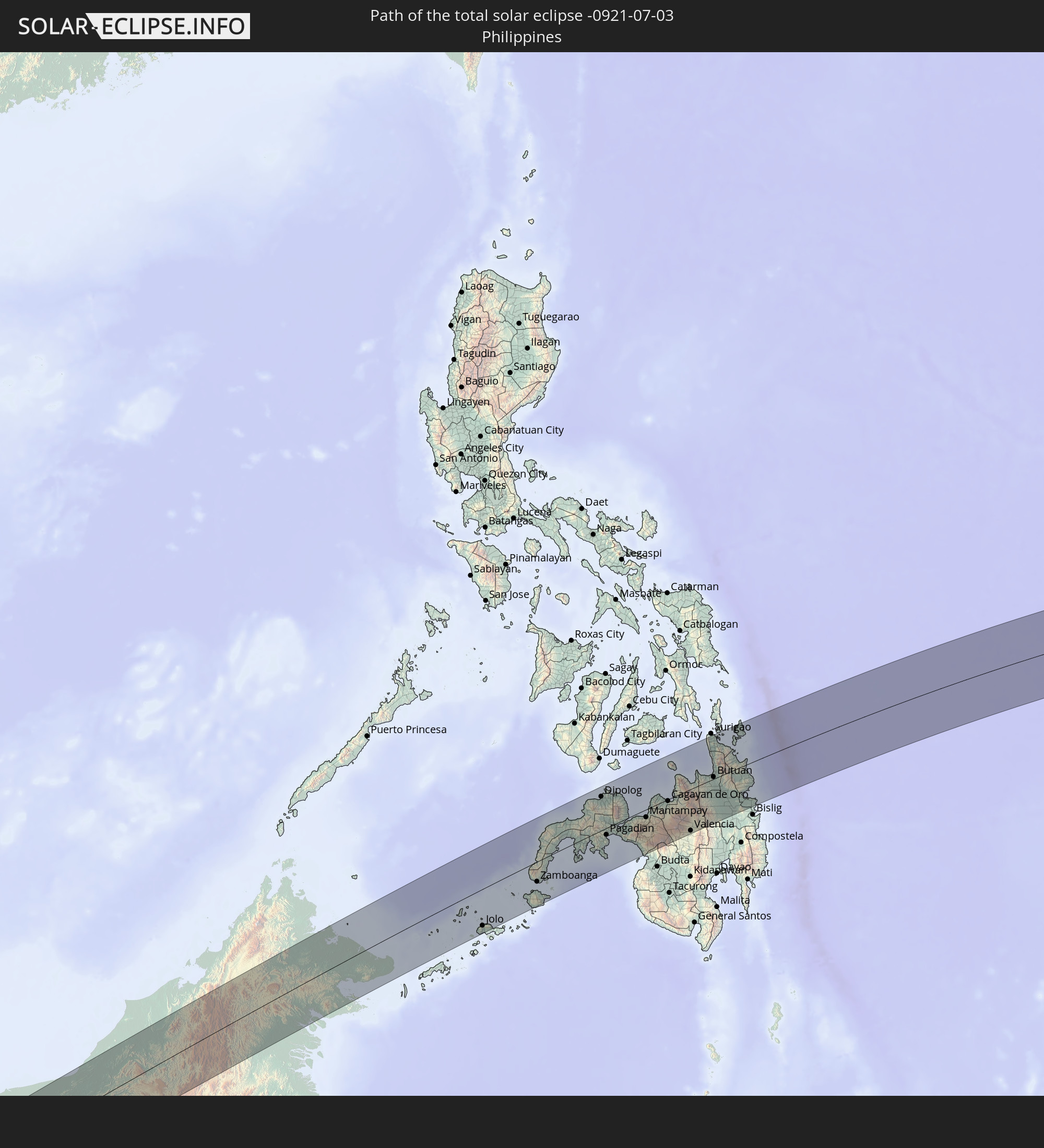 Philippines
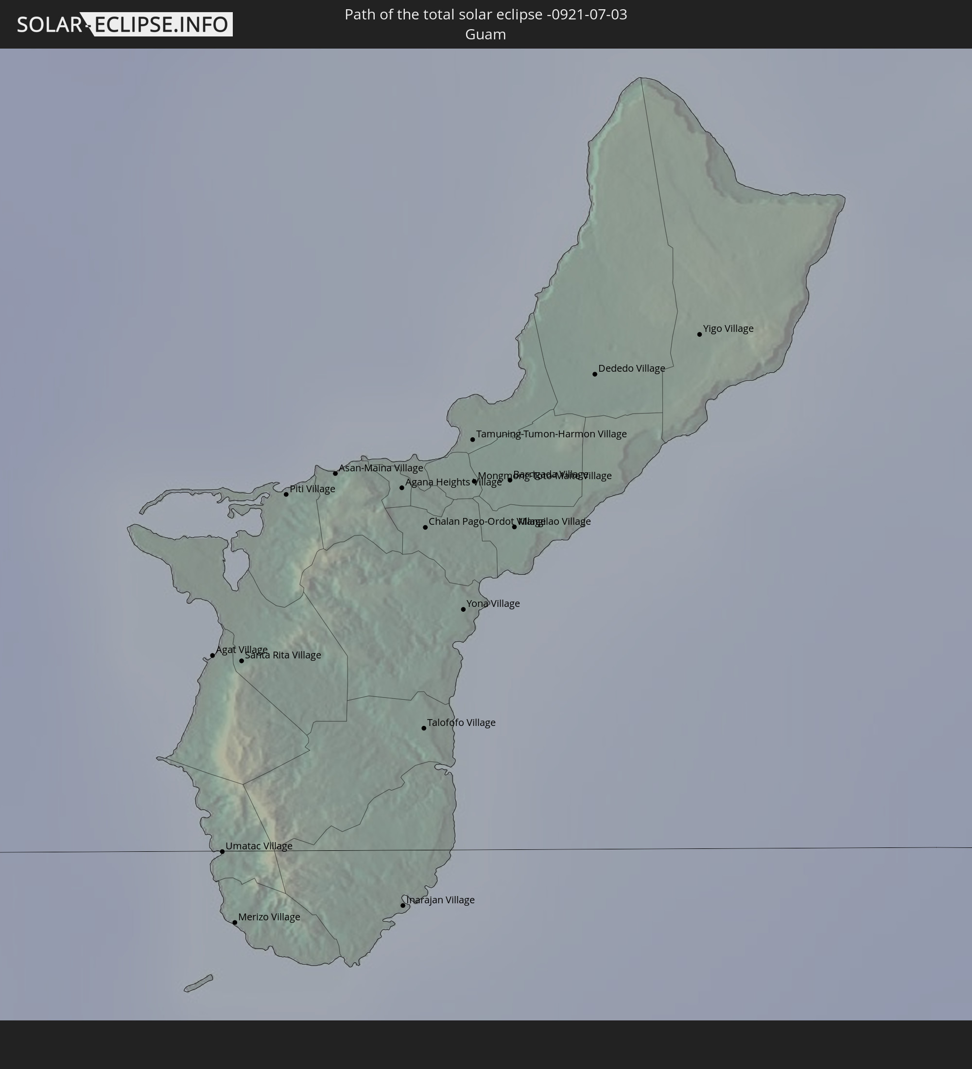 Guam
Guam
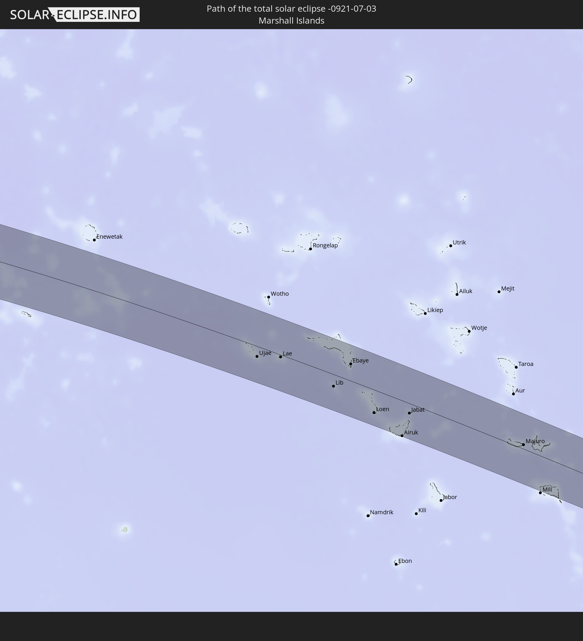 Marshall Islands
In den folgenden Ländern ist die Sonnenfinsternis partiell zu sehen
 Fiji
Fiji
 Russia
 United States
 New Zealand
 United States Minor Outlying Islands
 Wallis and Futuna
 Tonga
Tonga
 Kiribati
 Samoa
Samoa
 Tokelau
 American Samoa
 Niue
Niue
 Cook Islands
 India
India
 Maldives
 China
China
 Sri Lanka
 Bangladesh
 Bhutan
 Myanmar
 Indonesia
 Cocos Islands
 Thailand
 Malaysia
 Laos
Laos
 Vietnam
 Cambodia
 Singapore
 Christmas Island
 Australia
 Macau
Macau
 Hong Kong
 Brunei
 Taiwan
 Philippines
 Japan
Japan
 East Timor
 North Korea
 South Korea
 Palau
Palau
 Federated States of Micronesia
 Papua New Guinea
 Guam
Guam
 Northern Mariana Islands
 Solomon Islands
 New Caledonia
 Marshall Islands
 Vanuatu
 Nauru
Nauru
 Tuvalu
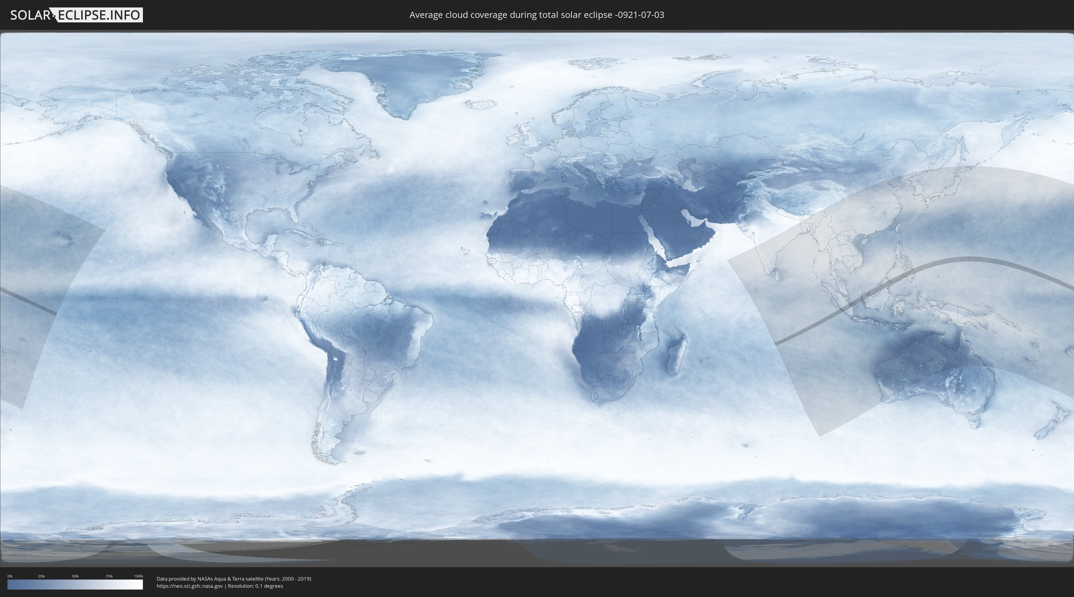
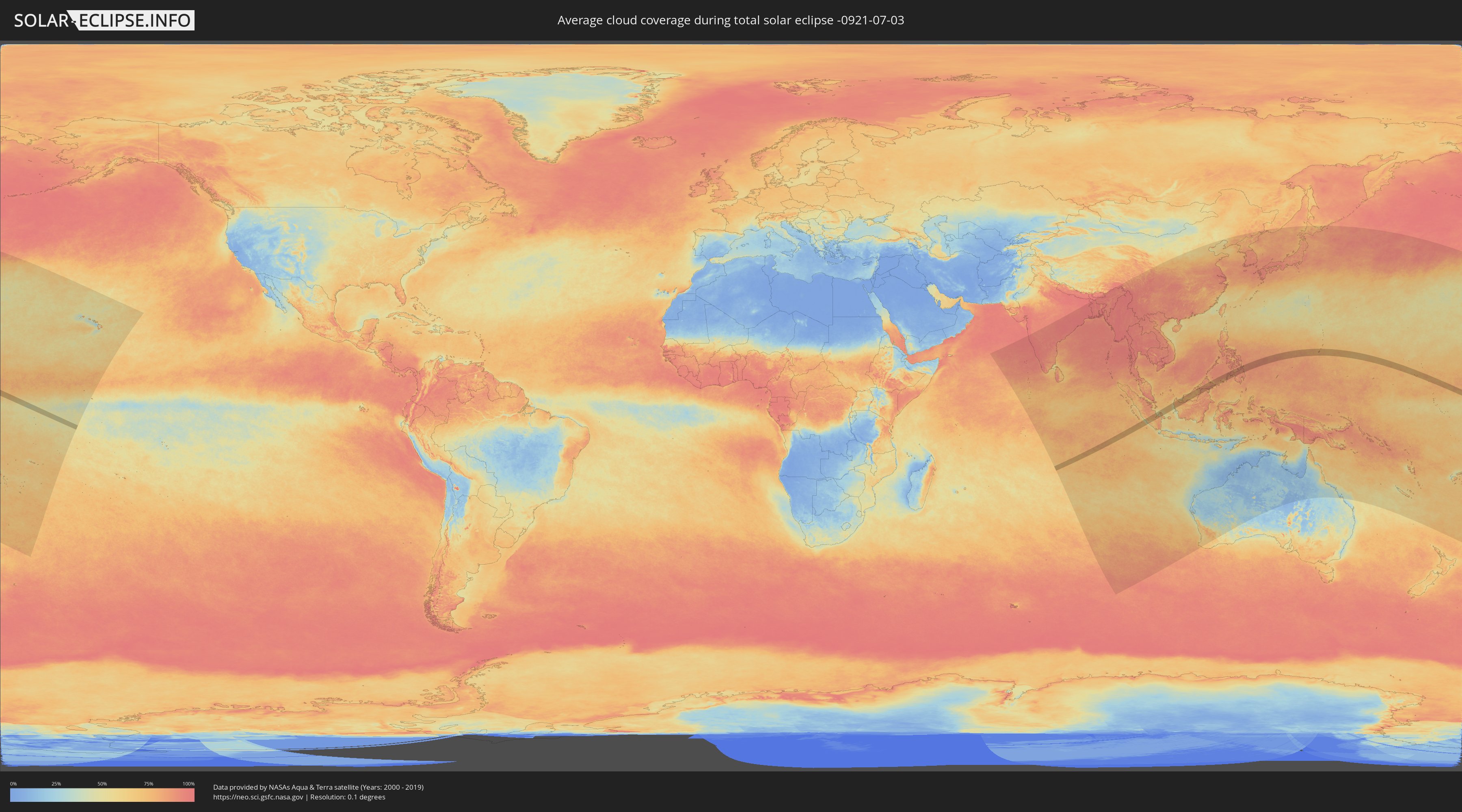
How will be the weather during the total solar eclipse on 07/03/-0921?
Where is the best place to see the total solar eclipse of 07/03/-0921?
The following maps show the average cloud coverage for the day of the total solar eclipse.
With the help of these maps, it is possible to find the place along the eclipse path, which has the best
chance of a cloudless sky.
Nevertheless, you should consider local circumstances and inform about the weather of your chosen
observation site.
The data is provided by NASAs satellites
AQUA and TERRA.
The cloud maps are averaged over a period of 19 years (2000 - 2019).
Detailed country maps
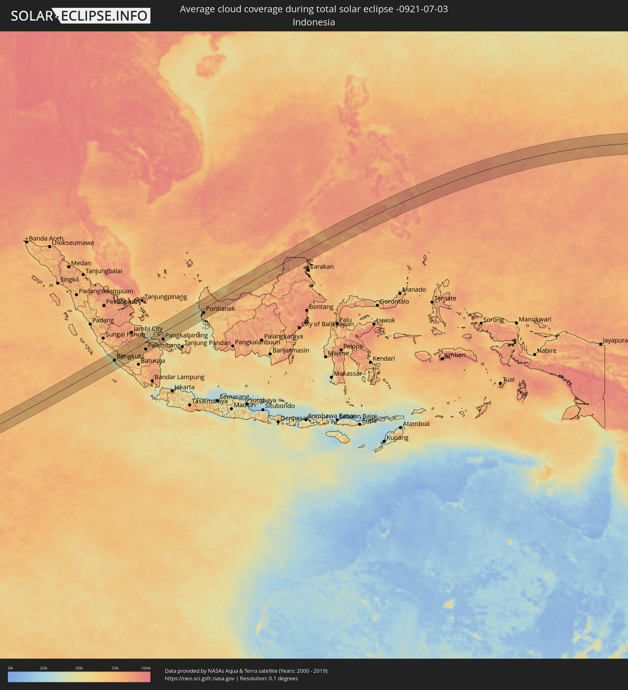 Indonesia
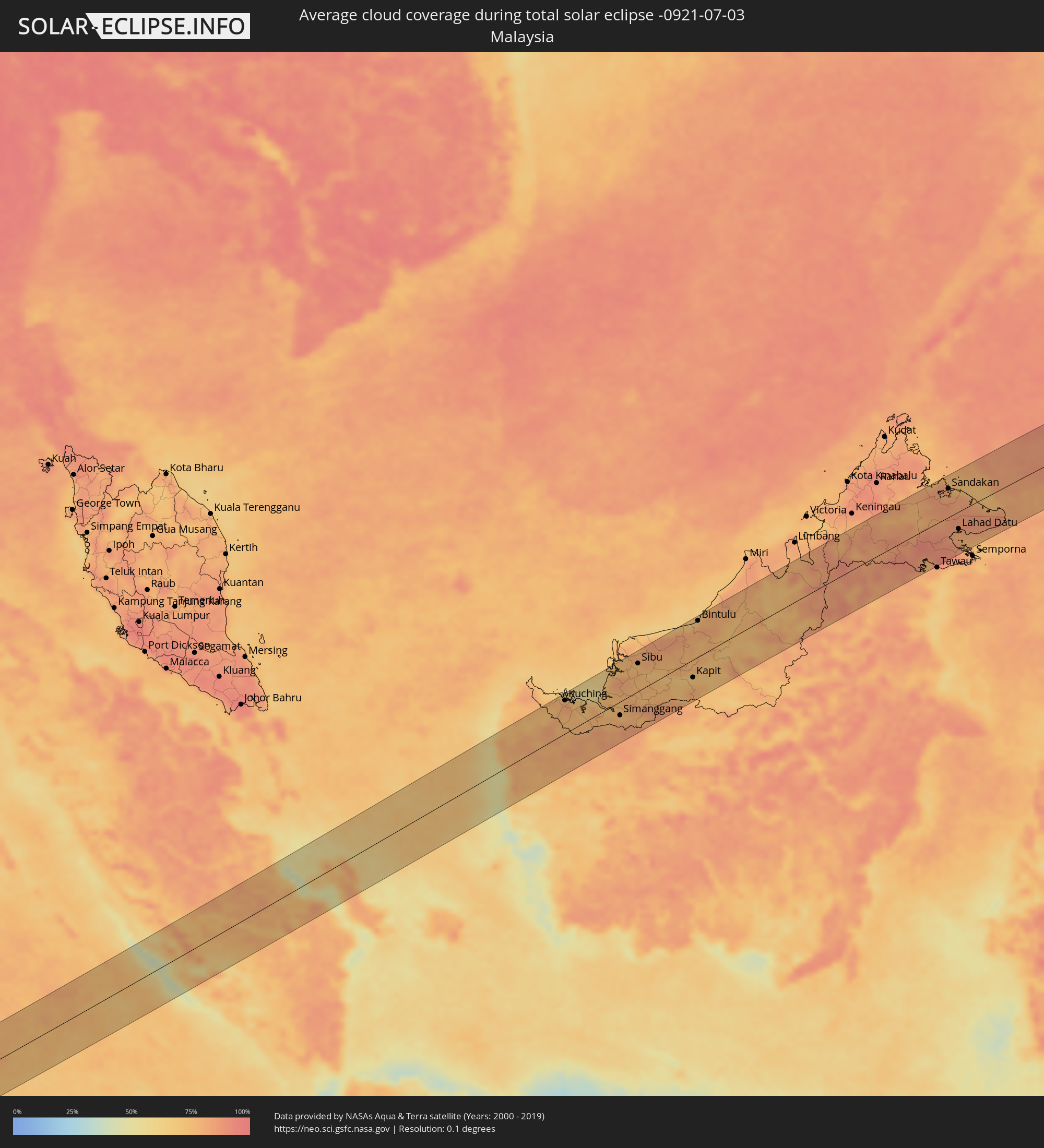 Malaysia
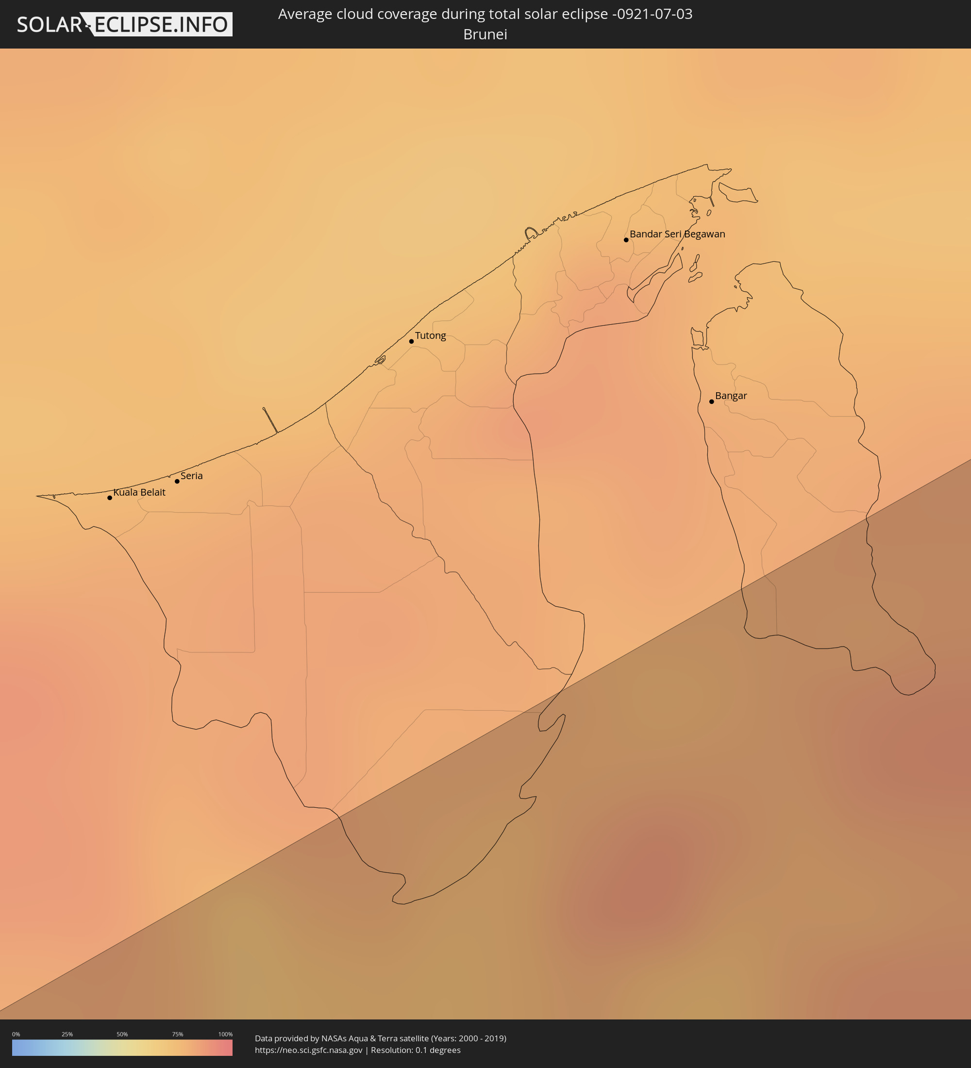 Brunei
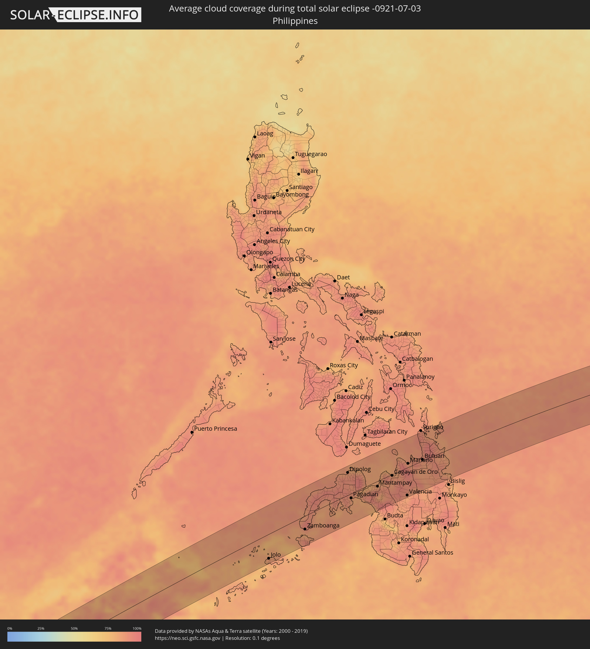 Philippines
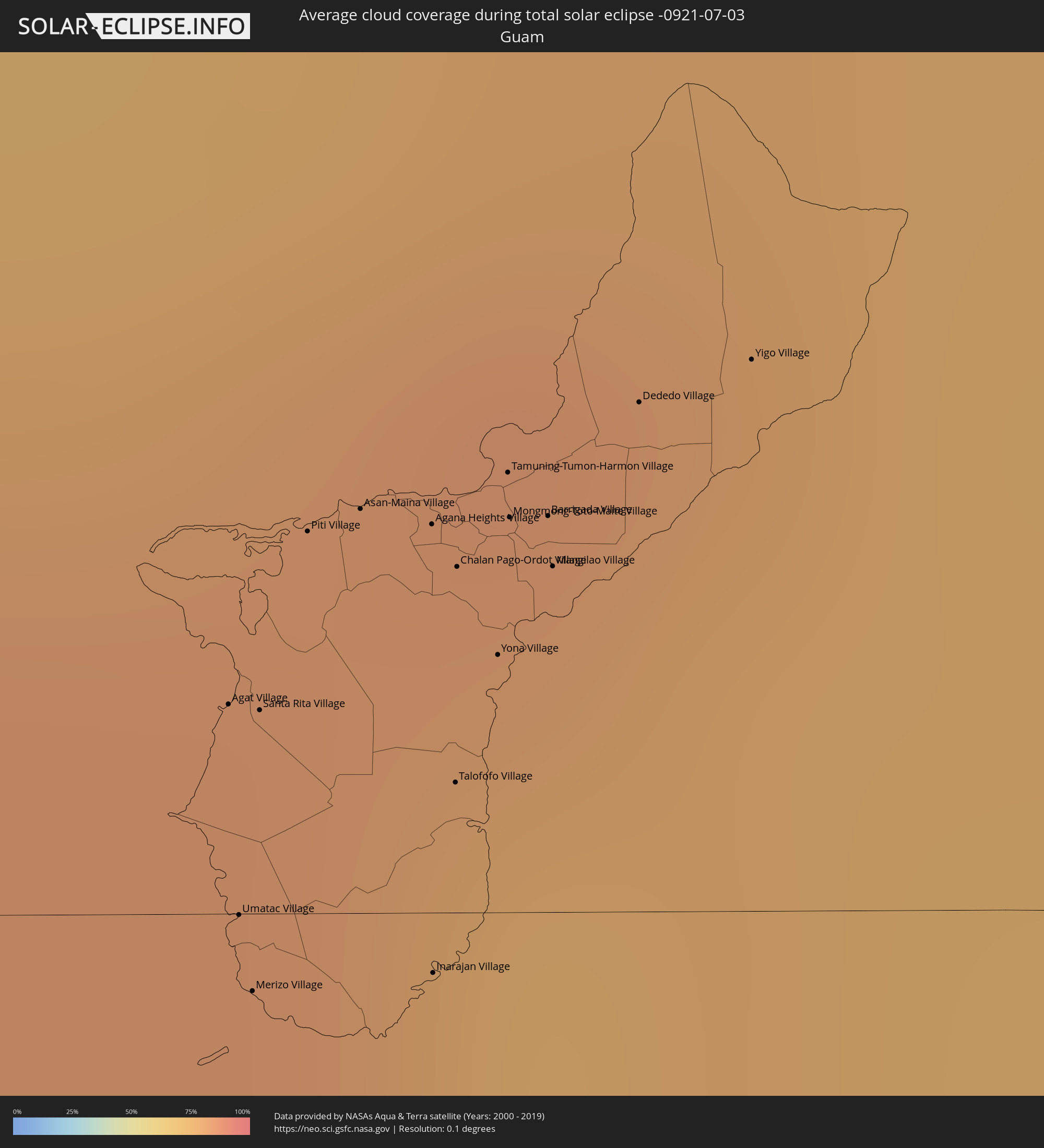 Guam
Guam
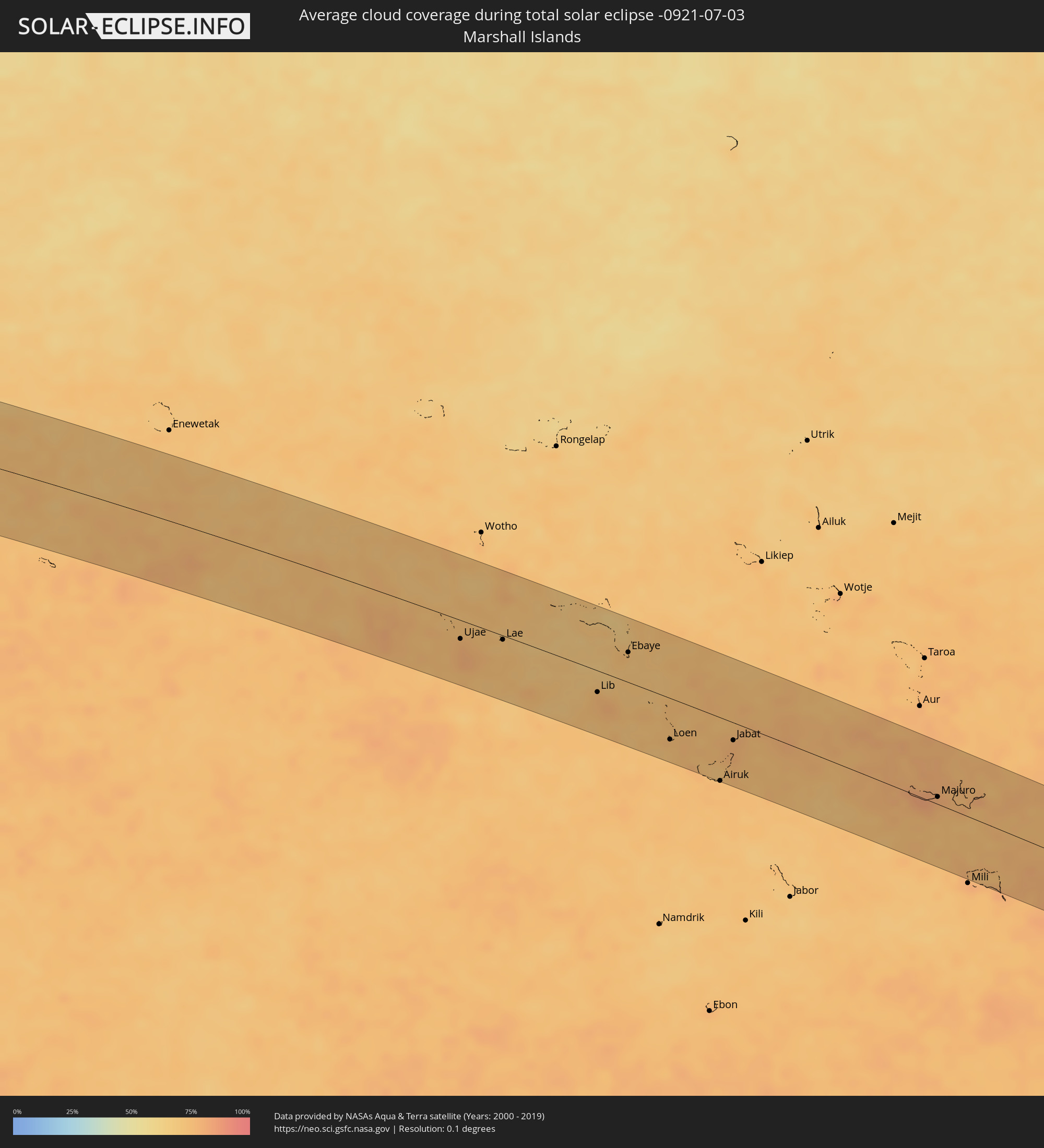 Marshall Islands
Cities inside the path of the eclipse
The following table shows all locations with a population of more than 5,000 inside the eclipse path. Cities which have more than 100,000 inhabitants are marked bold. A click at the locations opens a detailed map.
| City | Type | Eclipse duration | Local time of max. eclipse | Distance to central line | Ø Cloud coverage |
|
Bengkulu, Bengkulu
|
total | - | 08:23:58 UTC+07:07 | 1 km | 52% |
|
Curup, Bengkulu
|
total | - | 08:24:23 UTC+07:07 | 17 km | 67% |
|
Lubuklinggau, South Sumatra
|
total | - | 08:24:49 UTC+07:07 | 15 km | 74% |
|
Lahat, South Sumatra
|
total | - | 08:25:12 UTC+07:07 | 70 km | 62% |
|
Prabumulih, South Sumatra
|
total | - | 08:26:06 UTC+07:07 | 74 km | 78% |
|
Palembang, South Sumatra
|
total | - | 08:26:57 UTC+07:07 | 53 km | 83% |
|
Muntok, Bangka–Belitung Islands
|
total | - | 08:27:55 UTC+07:07 | 6 km | 51% |
|
Pangkalpinang, Bangka–Belitung Islands
|
total | - | 08:28:57 UTC+07:07 | 53 km | 76% |
|
Sungailiat, Bangka–Belitung Islands
|
total | - | 08:29:08 UTC+07:07 | 27 km | 74% |
|
Sungai Raya, West Kalimantan
|
total | - | 08:34:24 UTC+07:07 | 63 km | 60% |
|
Singkawang, West Kalimantan
|
total | - | 08:34:41 UTC+07:07 | 78 km | 75% |
|
Pontianak, West Kalimantan
|
total | - | 08:34:26 UTC+07:07 | 31 km | 81% |
|
Kuching, Sarawak
|
total | - | 08:51:12 UTC+07:21 | 65 km | 81% |
|
Simanggang, Sarawak
|
total | - | 08:52:37 UTC+07:21 | 27 km | 79% |
|
Sarikei, Sarawak
|
total | - | 08:53:25 UTC+07:21 | 54 km | 81% |
|
Sibu, Sarawak
|
total | - | 08:54:02 UTC+07:21 | 55 km | 74% |
|
Kapit, Sarawak
|
total | - | 08:55:34 UTC+07:21 | 35 km | 74% |
|
Bintulu, Sarawak
|
total | - | 08:56:43 UTC+07:21 | 71 km | 71% |
|
Taman Rajawali, Sabah
|
total | - | 09:08:23 UTC+07:21 | 66 km | 85% |
|
Sandakan, Sabah
|
total | - | 09:08:28 UTC+07:21 | 57 km | 80% |
|
Lahad Datu, Sabah
|
total | - | 09:08:07 UTC+07:21 | 34 km | 80% |
|
Jolo, Autonomous Region in Muslim Mindanao
|
total | - | 09:53:30 UTC+08:00 | 71 km | 84% |
|
Maluso, Autonomous Region in Muslim Mindanao
|
total | - | 09:55:59 UTC+08:00 | 66 km | 83% |
|
Labuan, Zamboanga Peninsula
|
total | - | 09:56:35 UTC+08:00 | 12 km | 87% |
|
City of Isabela, Autonomous Region in Muslim Mindanao
|
total | - | 09:56:21 UTC+08:00 | 55 km | 87% |
|
Zamboanga, Zamboanga Peninsula
|
total | - | 09:56:48 UTC+08:00 | 39 km | 86% |
|
Sangali, Zamboanga Peninsula
|
total | - | 09:57:15 UTC+08:00 | 29 km | 88% |
|
Ipil, Zamboanga Peninsula
|
total | - | 09:58:52 UTC+08:00 | 23 km | 86% |
|
Katipunan, Zamboanga Peninsula
|
total | - | 09:59:15 UTC+08:00 | 9 km | 85% |
|
Manukan, Zamboanga Peninsula
|
total | - | 10:00:51 UTC+08:00 | 74 km | 89% |
|
Margosatubig, Zamboanga Peninsula
|
total | - | 10:00:03 UTC+08:00 | 25 km | 84% |
|
Dipolog, Zamboanga Peninsula
|
total | - | 10:01:27 UTC+08:00 | 66 km | 85% |
|
Pagadian, Zamboanga Peninsula
|
total | - | 10:00:58 UTC+08:00 | 13 km | 85% |
|
Molave, Zamboanga Peninsula
|
total | - | 10:01:21 UTC+08:00 | 10 km | 89% |
|
Tucuran, Zamboanga Peninsula
|
total | - | 10:01:19 UTC+08:00 | 17 km | 81% |
|
Lala, Northern Mindanao
|
total | - | 10:01:52 UTC+08:00 | 13 km | 85% |
|
Oroquieta, Northern Mindanao
|
total | - | 10:02:31 UTC+08:00 | 36 km | 83% |
|
Ozamiz City, Northern Mindanao
|
total | - | 10:02:16 UTC+08:00 | 0 km | 81% |
|
Mantampay, Northern Mindanao
|
total | - | 10:03:13 UTC+08:00 | 15 km | 84% |
|
Dalipuga
|
total | - | 10:03:28 UTC+08:00 | 2 km | 83% |
|
Marawi City, Autonomous Region in Muslim Mindanao
|
total | - | 10:03:14 UTC+08:00 | 35 km | 82% |
|
Iligan City, Soccsksargen
|
total | - | 10:03:46 UTC+08:00 | 15 km | 85% |
|
Cagayan de Oro, Northern Mindanao
|
total | - | 10:04:37 UTC+08:00 | 3 km | 87% |
|
Wao, Autonomous Region in Muslim Mindanao
|
total | - | 10:03:53 UTC+08:00 | 85 km | 88% |
|
Mambajao, Northern Mindanao
|
total | - | 10:05:33 UTC+08:00 | 71 km | 87% |
|
Kalilangan, Northern Mindanao
|
total | - | 10:04:11 UTC+08:00 | 74 km | 88% |
|
Jasaan, Northern Mindanao
|
total | - | 10:05:04 UTC+08:00 | 9 km | 85% |
|
Manolo Fortich, Northern Mindanao
|
total | - | 10:05:03 UTC+08:00 | 25 km | 89% |
|
Valencia, Northern Mindanao
|
total | - | 10:05:12 UTC+08:00 | 82 km | 83% |
|
Mariano, Northern Mindanao
|
total | - | 10:06:09 UTC+08:00 | 11 km | 90% |
|
Malaybalay, Northern Mindanao
|
total | - | 10:05:31 UTC+08:00 | 58 km | 90% |
|
Buenavista, Caraga
|
total | - | 10:07:03 UTC+08:00 | 13 km | 88% |
|
Cabadbaran, Caraga
|
total | - | 10:07:31 UTC+08:00 | 22 km | 88% |
|
Butuan, Caraga
|
total | - | 10:07:22 UTC+08:00 | 4 km | 87% |
|
Placer, Caraga
|
total | - | 10:08:13 UTC+08:00 | 73 km | 86% |
|
Bayugan, Caraga
|
total | - | 10:07:46 UTC+08:00 | 26 km | 88% |
|
Talacogon, Caraga
|
total | - | 10:07:31 UTC+08:00 | 57 km | 85% |
|
Bah-Bah, Caraga
|
total | - | 10:08:01 UTC+08:00 | 47 km | 90% |
|
Lianga, Caraga
|
total | - | 10:08:31 UTC+08:00 | 53 km | 85% |
|
Tagbina, Caraga
|
total | - | 10:08:32 UTC+08:00 | 75 km | 88% |
|
Tandag, Caraga
|
total | - | 10:09:13 UTC+08:00 | 12 km | 82% |
|
Agat Village, Agat
|
total | - | 13:08:44 UTC+10:00 | 10 km | 82% |
|
Umatac Village, Umatac
|
total | - | 13:08:44 UTC+10:00 | 0 km | 81% |
|
Merizo Village, Merizo
|
total | - | 13:08:45 UTC+10:00 | 4 km | 81% |
|
Santa Rita Village, Santa Rita
|
total | - | 13:08:47 UTC+10:00 | 10 km | 82% |
|
Piti Village, Piti
|
total | - | 13:08:51 UTC+10:00 | 18 km | 82% |
|
Asan-Maina Village, Asan
|
total | - | 13:08:56 UTC+10:00 | 19 km | 82% |
|
Agana Heights Village, Agana Heights
|
total | - | 13:09:01 UTC+10:00 | 18 km | 82% |
|
Inarajan Village, Inarajan
|
total | - | 13:09:00 UTC+10:00 | 3 km | 81% |
|
Hagåtña, Hagatna
|
total | - | 13:09:02 UTC+10:00 | 20 km | 82% |
|
Guam Government House, Hagatna
|
total | - | 13:09:02 UTC+10:00 | 19 km | 82% |
|
Sinajana Village, Sinajana
|
total | - | 13:09:03 UTC+10:00 | 18 km | 80% |
|
Talofofo Village, Talofofo
|
total | - | 13:09:02 UTC+10:00 | 6 km | 75% |
|
Chalan Pago-Ordot Village, Chalan Pago-Ordot
|
total | - | 13:09:03 UTC+10:00 | 16 km | 75% |
|
Yona Village, Yona
|
total | - | 13:09:06 UTC+10:00 | 12 km | 75% |
|
Tamuning-Tumon-Harmon Village, Tamuning
|
total | - | 13:09:08 UTC+10:00 | 21 km | 80% |
|
Mongmong-Toto-Maite Village, Mongmong-Toto-Maite
|
total | - | 13:09:08 UTC+10:00 | 19 km | 80% |
|
Barrigada Village, Barrigada
|
total | - | 13:09:11 UTC+10:00 | 19 km | 80% |
|
Mangilao Village, Mangilao
|
total | - | 13:09:11 UTC+10:00 | 16 km | 75% |
|
Dededo Village, Dededo
|
total | - | 13:09:19 UTC+10:00 | 24 km | 80% |
|
Yigo Village, Yigo
|
total | - | 13:09:28 UTC+10:00 | 26 km | 76% |
|
Ujae, Ujae Atoll
|
total | - | 15:02:53 UTC+11:00 | 23 km | 78% |
|
Lae, Lae Atoll
|
total | - | 15:03:45 UTC+11:00 | 5 km | 71% |
|
Lib, Lib Island
|
total | - | 15:05:51 UTC+11:00 | 26 km | 76% |
|
Ebaye, Kwajalein Atoll
|
total | - | 15:06:14 UTC+11:00 | 36 km | 74% |
|
Loen, Namu Atoll
|
total | - | 15:07:27 UTC+11:00 | 50 km | 75% |
|
Airuk, Ailinglaplap Atoll
|
total | - | 15:08:34 UTC+11:00 | 77 km | 75% |
|
Jabat, Jabat Island
|
total | - | 15:08:35 UTC+11:00 | 21 km | 77% |
|
Majuro, Majuro Atoll
|
total | - | 15:12:17 UTC+11:00 | 9 km | 79% |
|
RMI Capitol, Majuro Atoll
|
total | - | 15:12:17 UTC+11:00 | 9 km | 79% |
|
Arno, Arno Atoll
|
total | - | 15:12:31 UTC+11:00 | 14 km | 76% |