Total solar eclipse of 01/27/-0950
| Day of week: | Friday |
| Maximum duration of eclipse: | 04m25s |
| Maximum width of eclipse path: | 183 km |
| Saros cycle: | 35 |
| Coverage: | 100% |
| Magnitude: | 1.0541 |
| Gamma: | -0.2071 |
Wo kann man die Sonnenfinsternis vom 01/27/-0950 sehen?
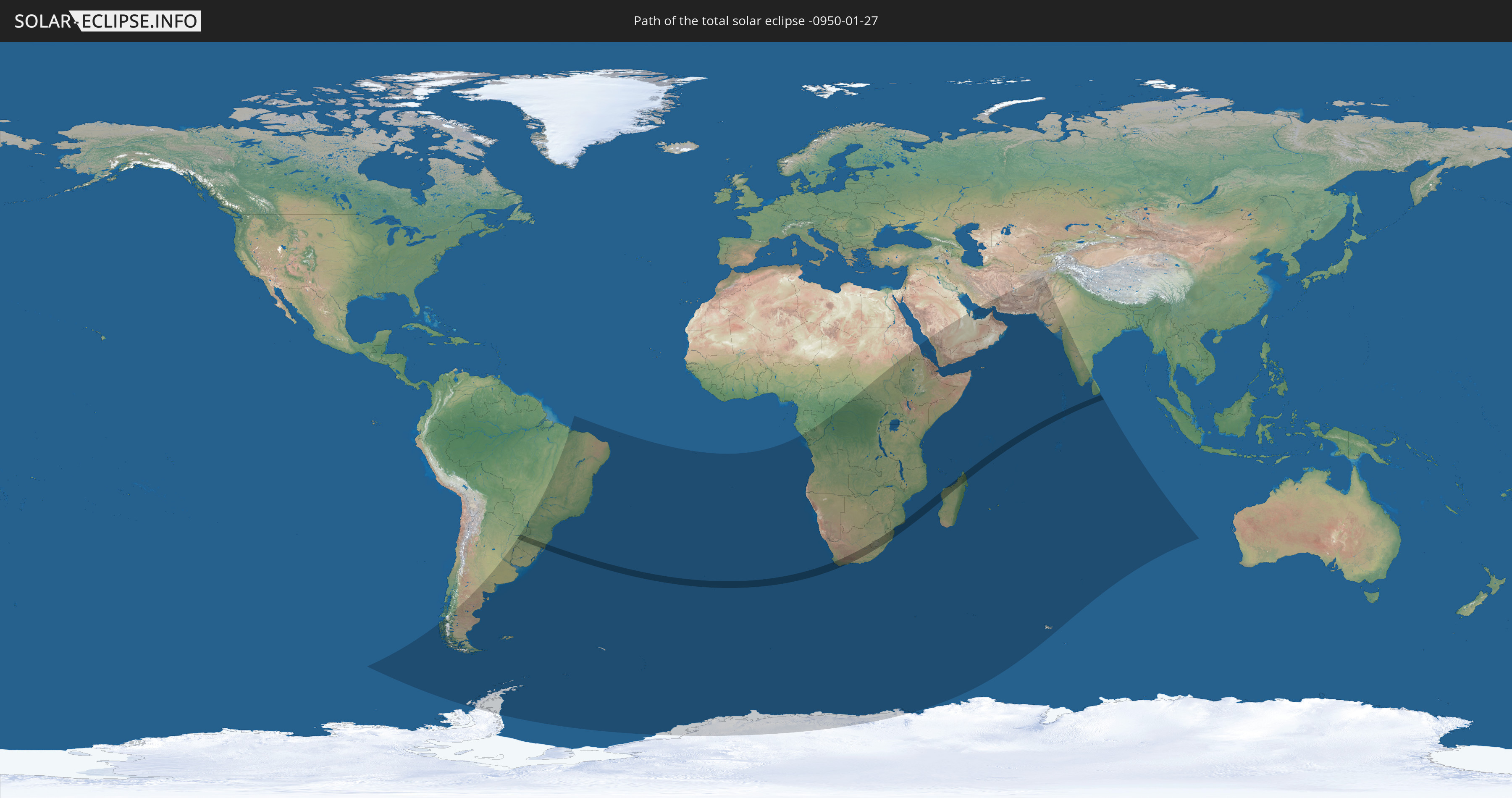
Die Sonnenfinsternis am 01/27/-0950 kann man in 54 Ländern als partielle Sonnenfinsternis beobachten.
Der Finsternispfad verläuft durch 9 Länder. Nur in diesen Ländern ist sie als total Sonnenfinsternis zu sehen.
In den folgenden Ländern ist die Sonnenfinsternis total zu sehen
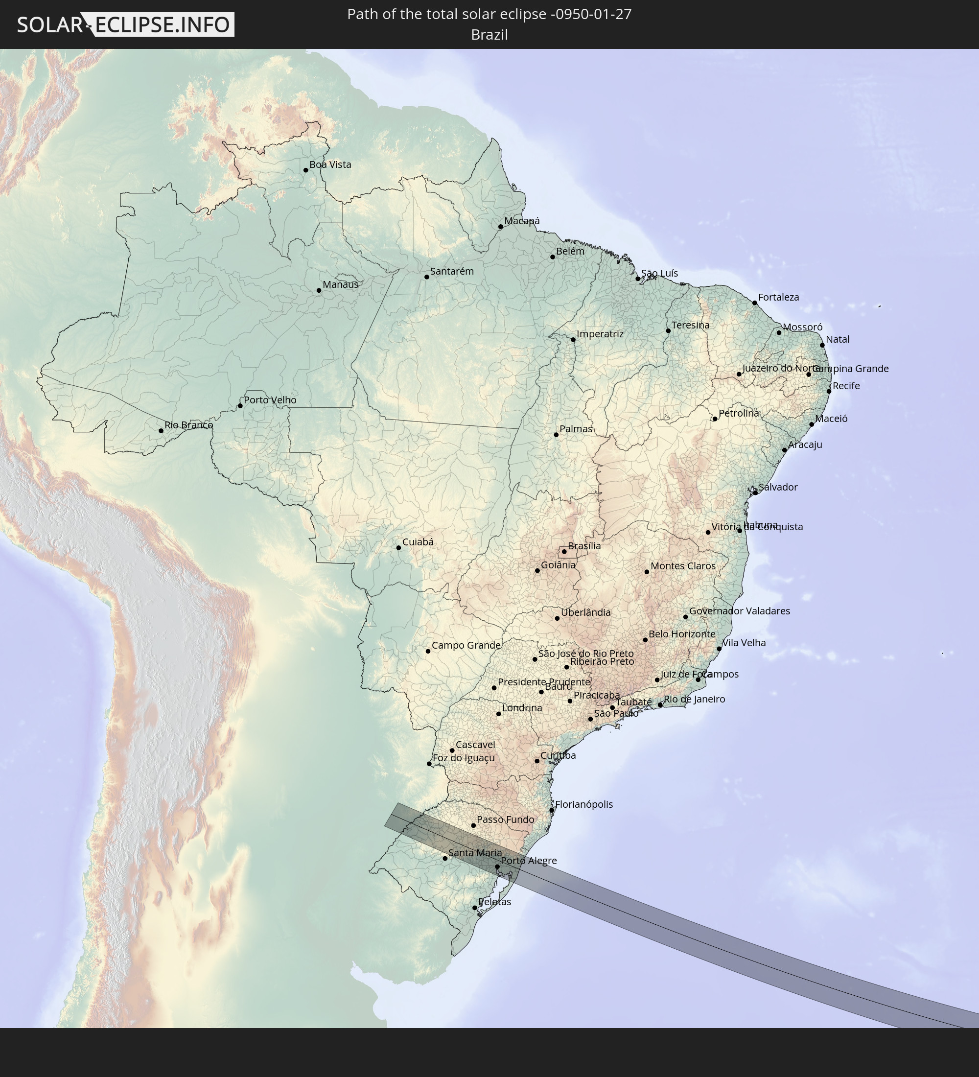 Brazil
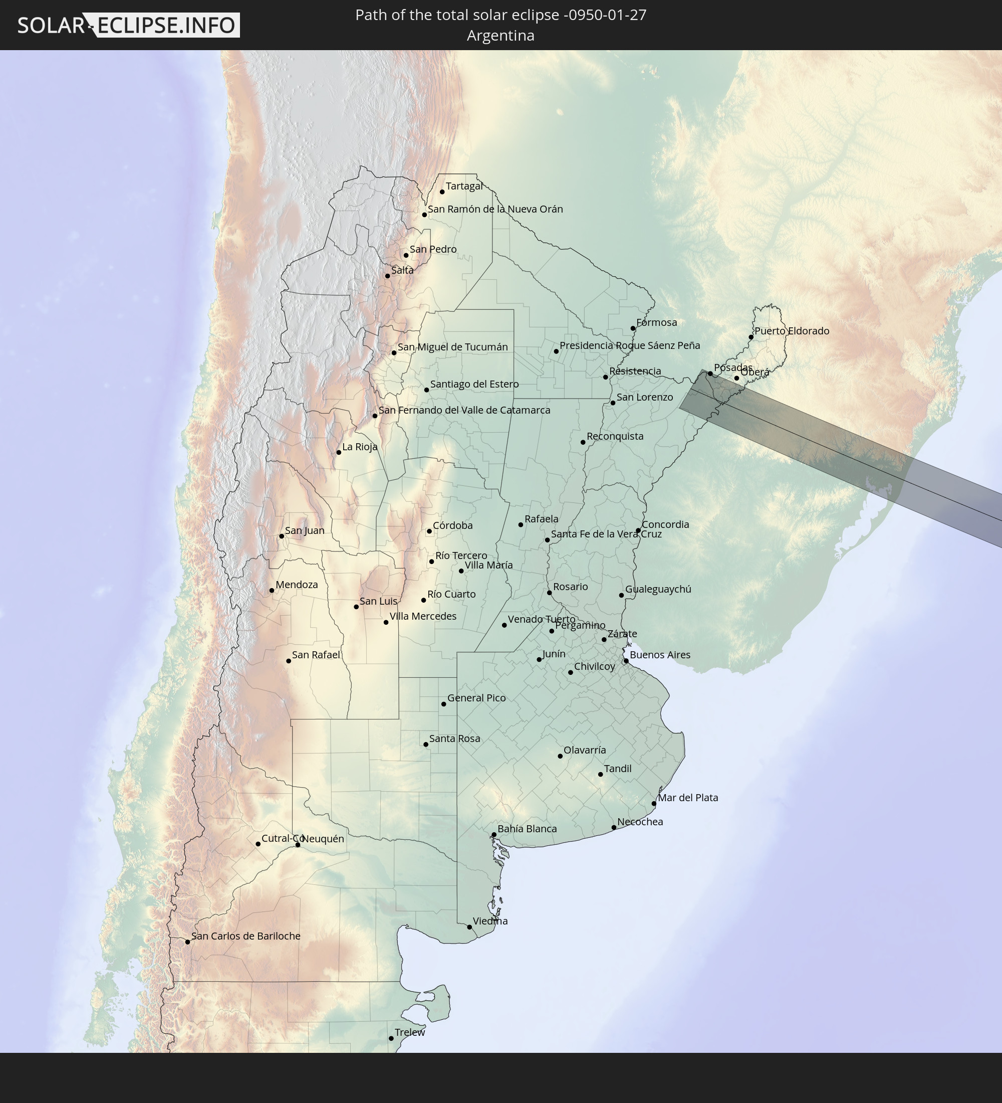 Argentina
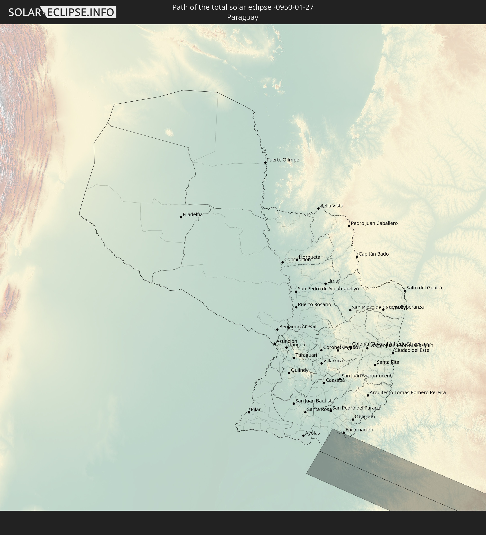 Paraguay
 South Africa
 Lesotho
 Mozambique
 Swaziland
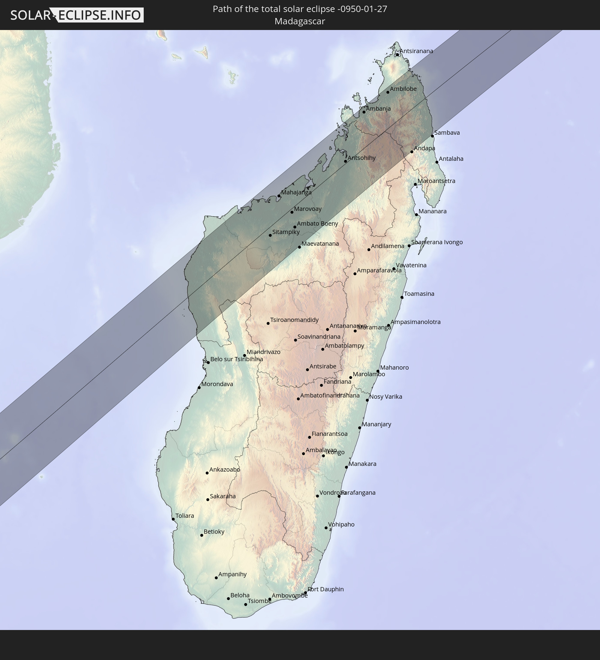 Madagascar
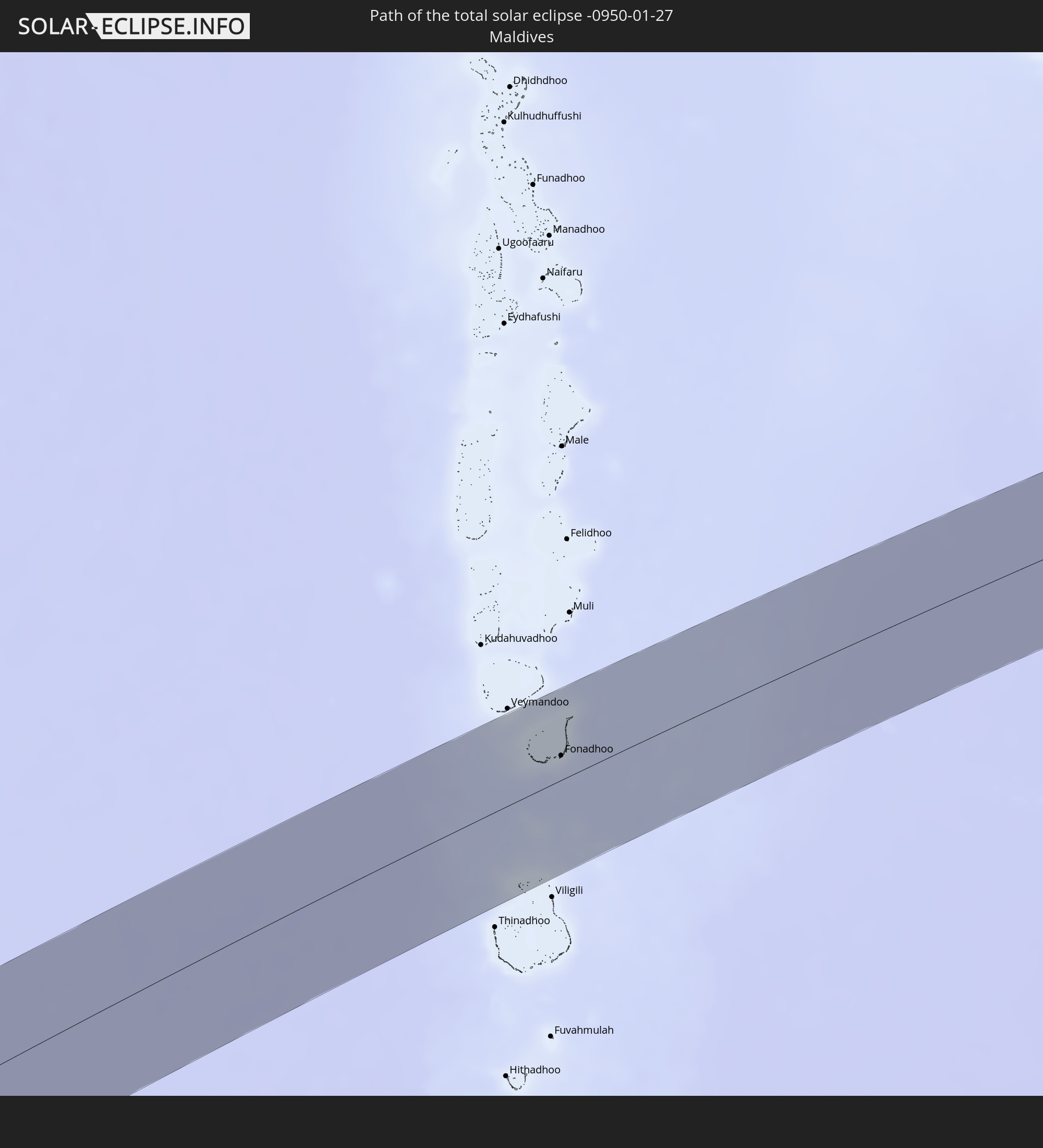 Maldives
In den folgenden Ländern ist die Sonnenfinsternis partiell zu sehen
 Antarctica
 Chile
Chile
 Brazil
 Argentina
 Paraguay
 Falkland Islands
 Uruguay
 South Georgia and the South Sandwich Islands
 Saint Helena, Ascension and Tristan da Cunha
 Bouvet Island
 Gabon
Gabon
 Republic of the Congo
 Angola
 Namibia
 Democratic Republic of the Congo
 Central African Republic
 South Africa
 Botswana
 Sudan
Sudan
 Zambia
 Zimbabwe
 Lesotho
 Rwanda
 Burundi
 Tanzania
 Uganda
 Mozambique
 Swaziland
 Malawi
 Ethiopia
 Kenya
Kenya
 Saudi Arabia
 Eritrea
 French Southern and Antarctic Lands
 Somalia
 Djibouti
 Yemen
Yemen
 Madagascar
 Comoros
 Iran
Iran
 Mayotte
 Seychelles
 Bahrain
 Qatar
Qatar
 United Arab Emirates
 Oman
Oman
 Réunion
 Mauritius
 Afghanistan
 Pakistan
 India
India
 British Indian Ocean Territory
 Maldives
 Sri Lanka
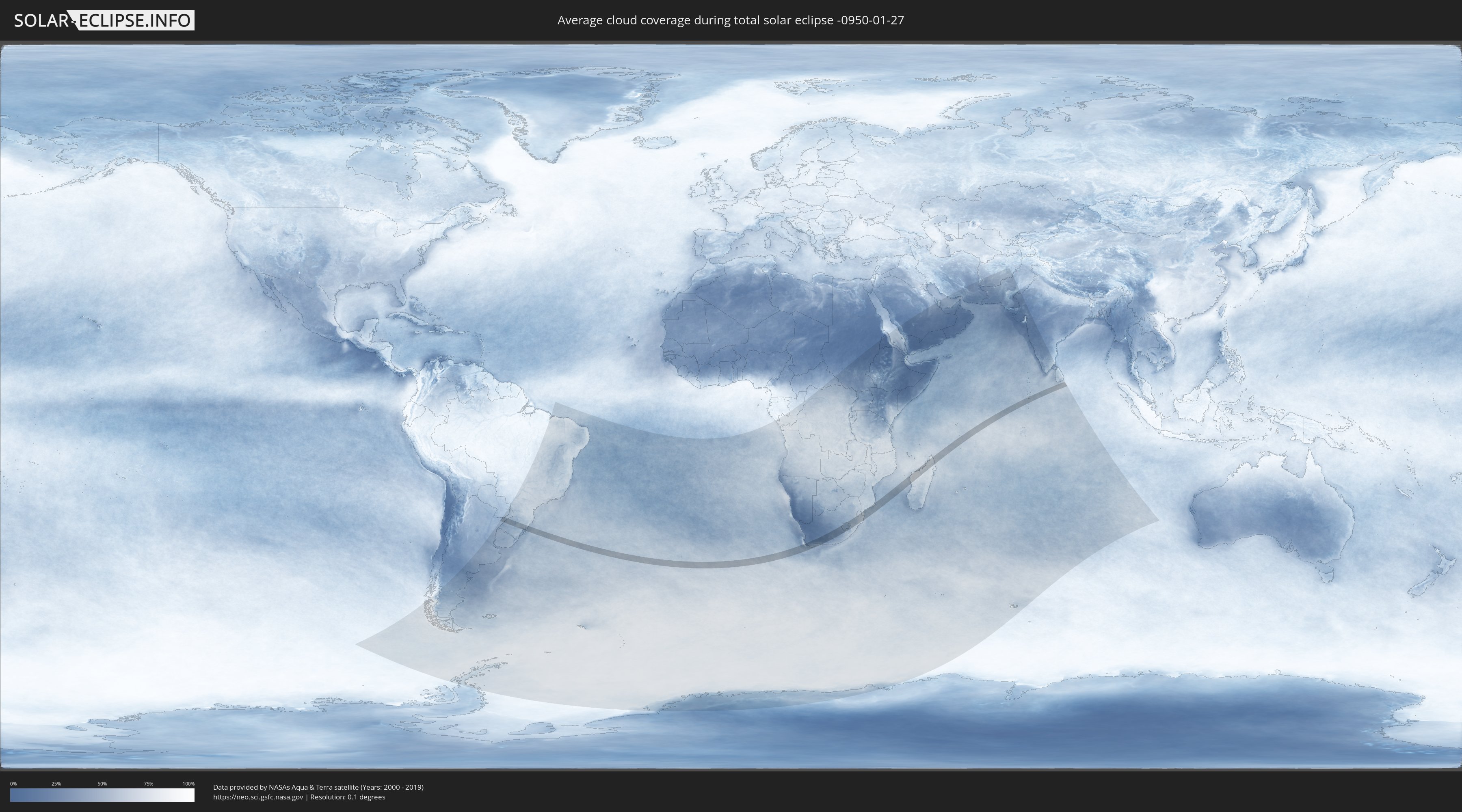
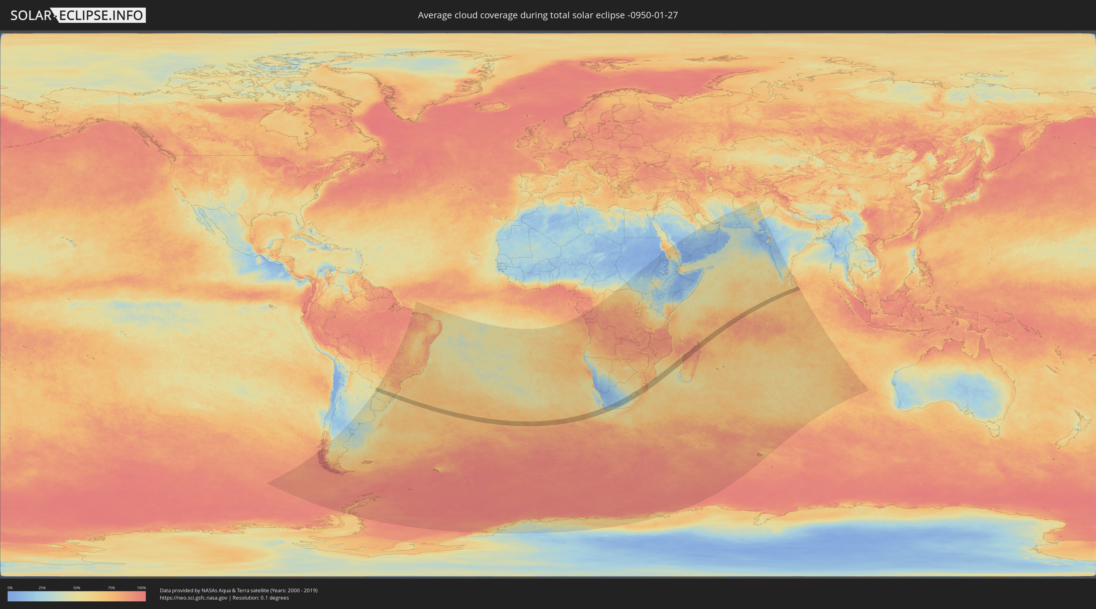
How will be the weather during the total solar eclipse on 01/27/-0950?
Where is the best place to see the total solar eclipse of 01/27/-0950?
The following maps show the average cloud coverage for the day of the total solar eclipse.
With the help of these maps, it is possible to find the place along the eclipse path, which has the best
chance of a cloudless sky.
Nevertheless, you should consider local circumstances and inform about the weather of your chosen
observation site.
The data is provided by NASAs satellites
AQUA and TERRA.
The cloud maps are averaged over a period of 19 years (2000 - 2019).
Detailed country maps
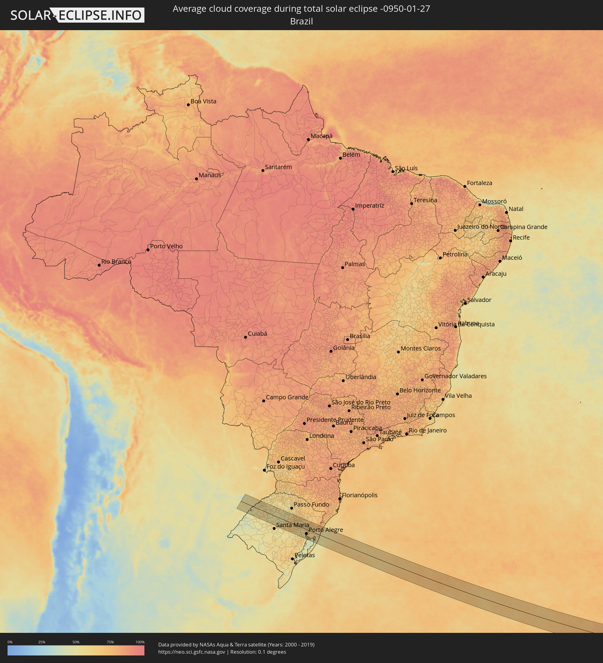 Brazil
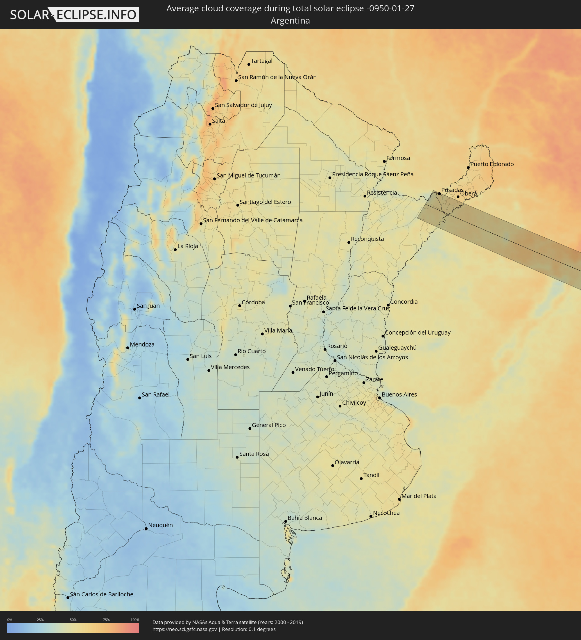 Argentina
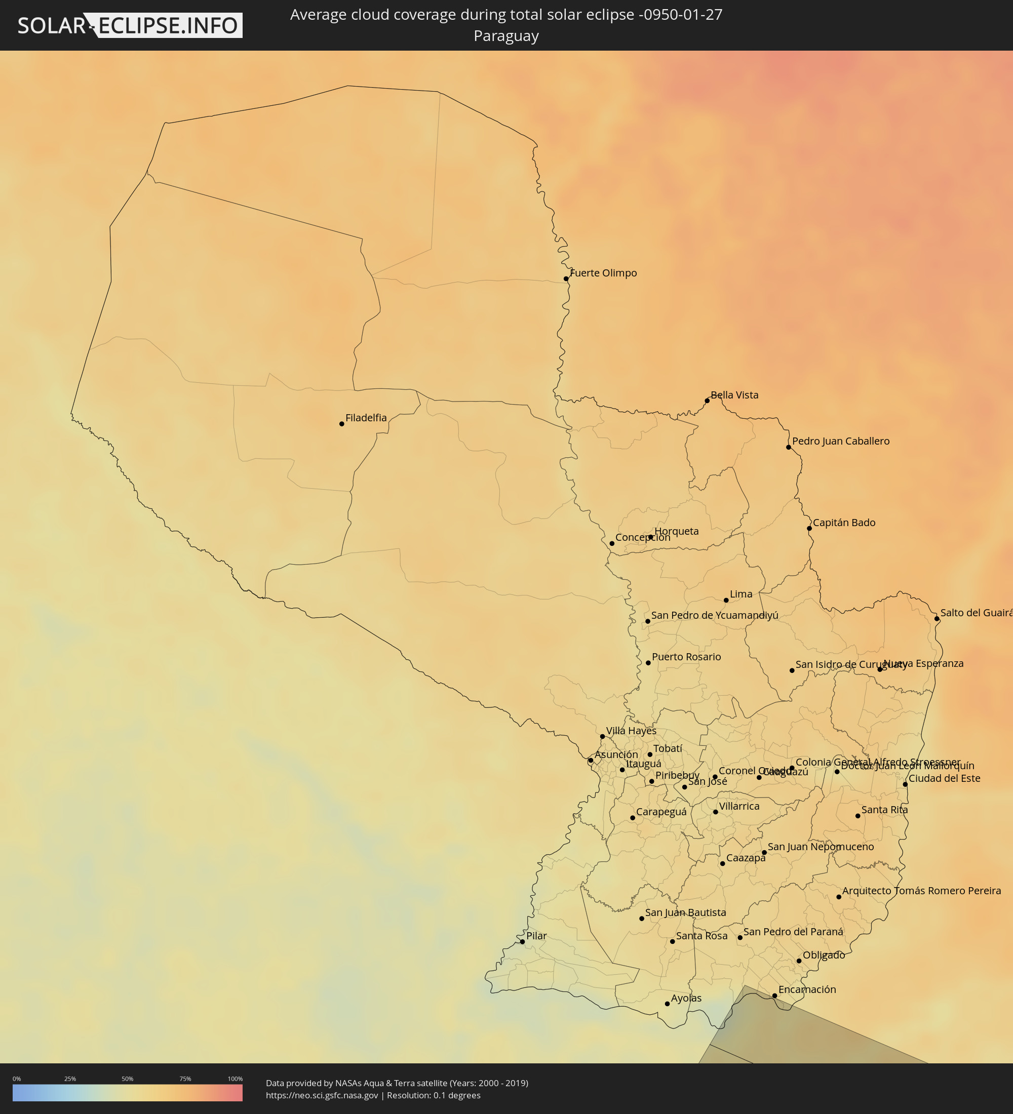 Paraguay
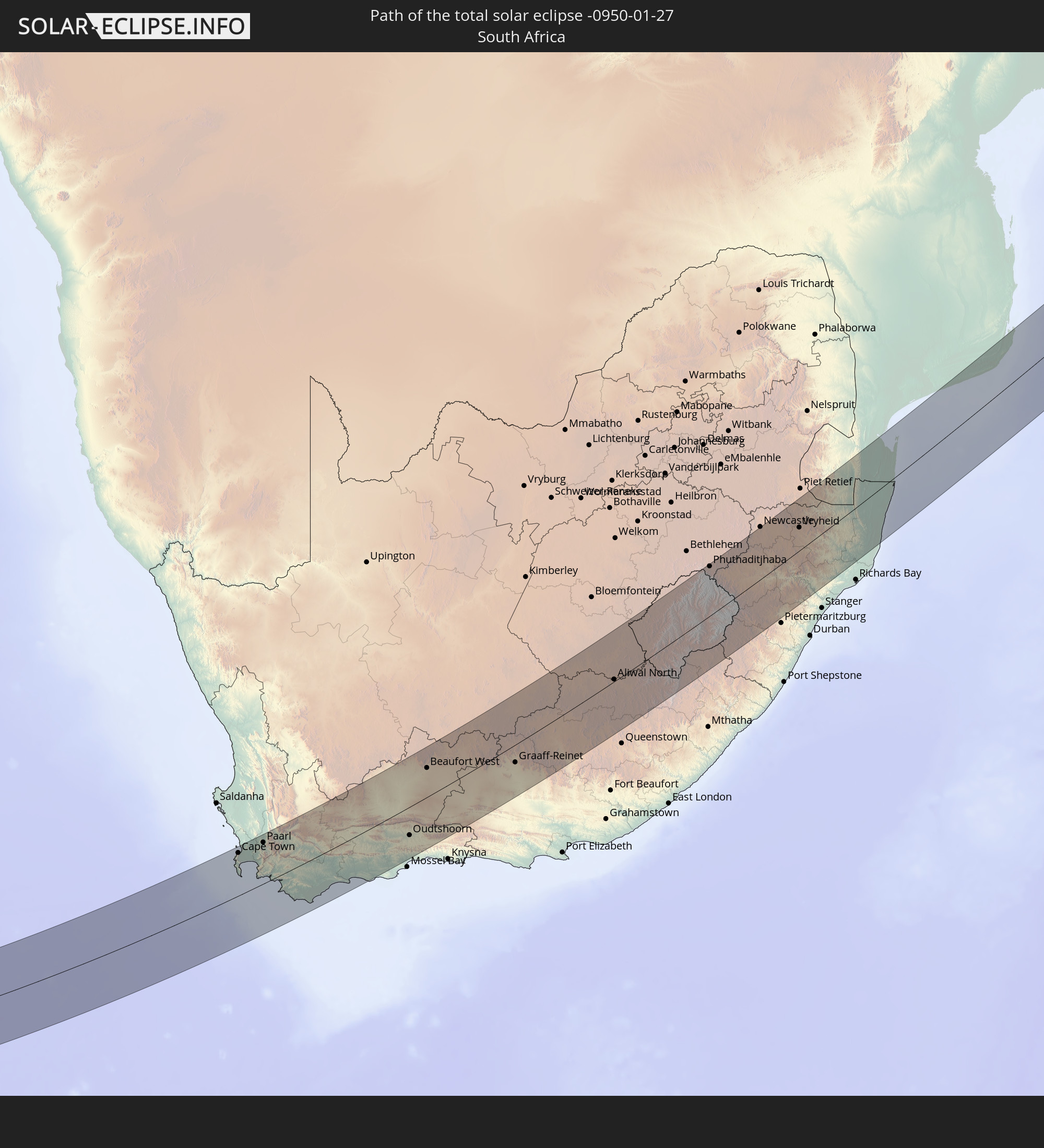
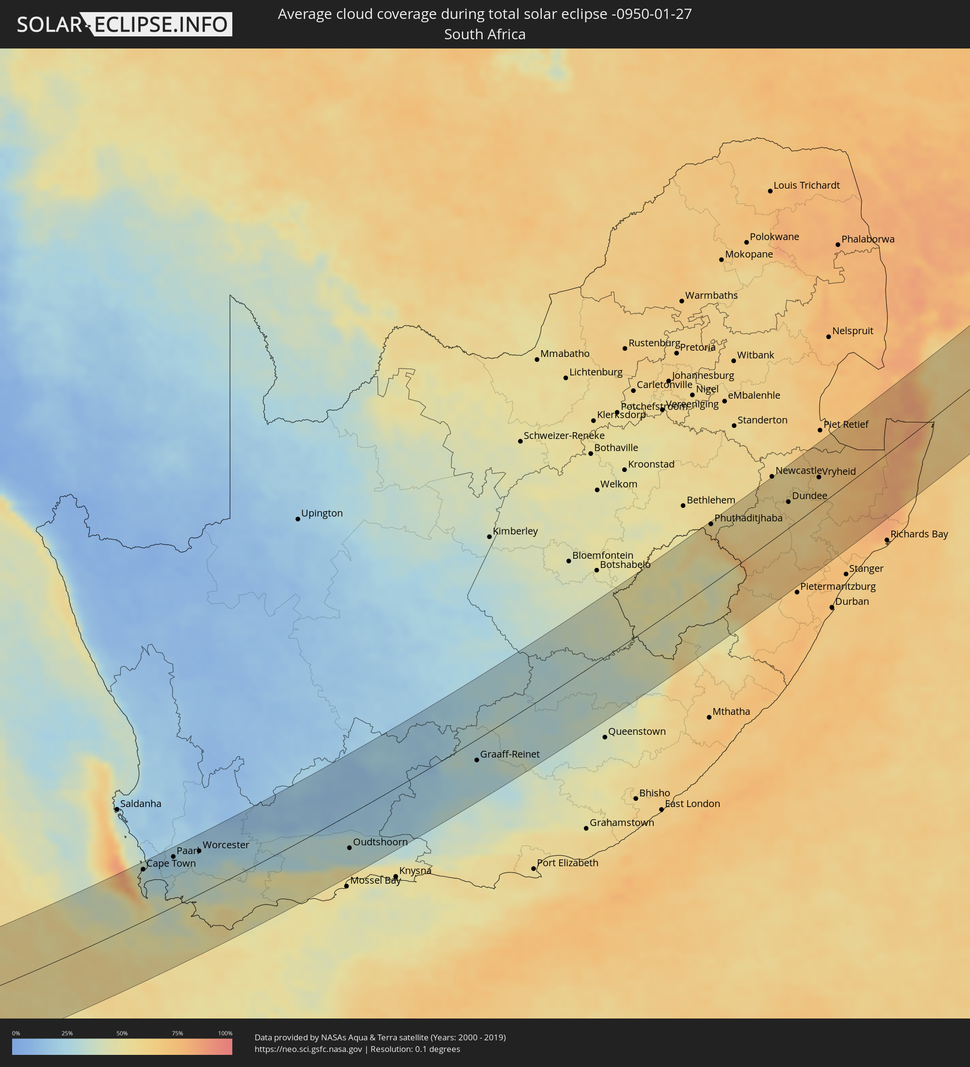 South Africa
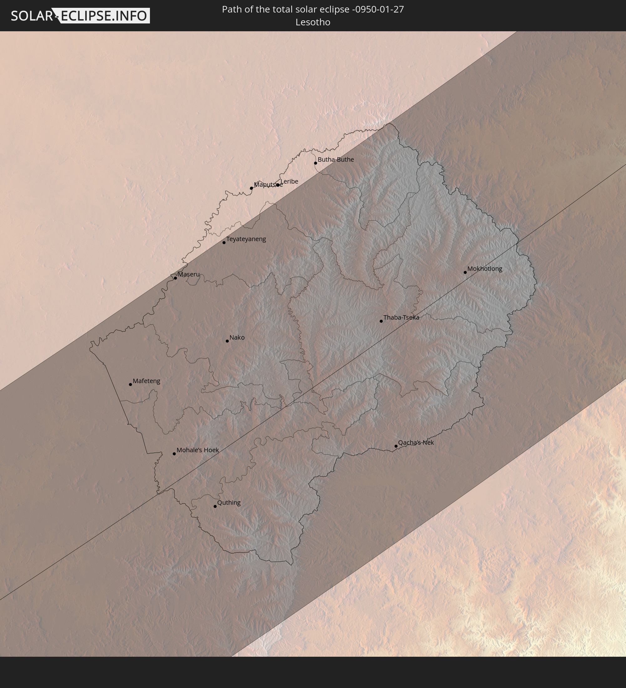
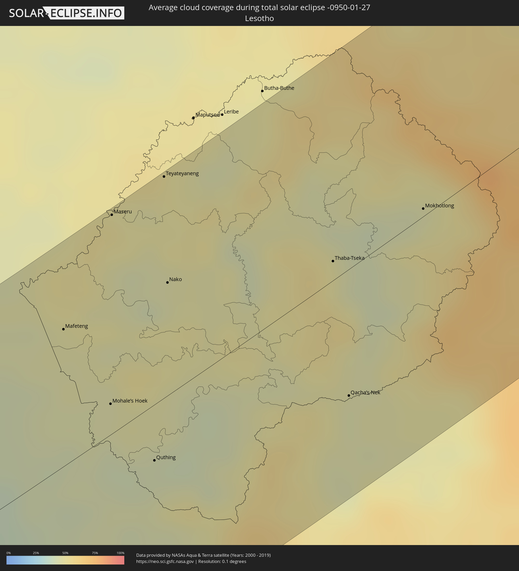 Lesotho
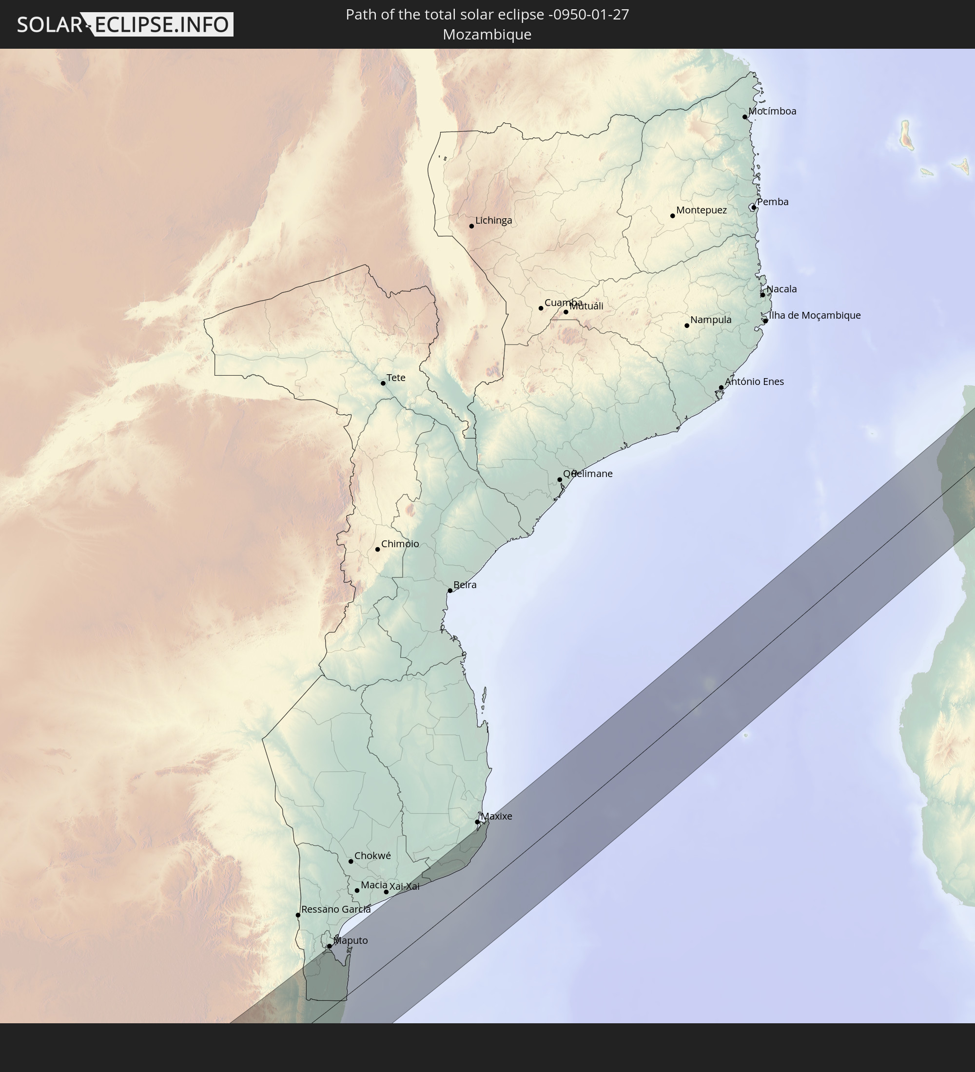
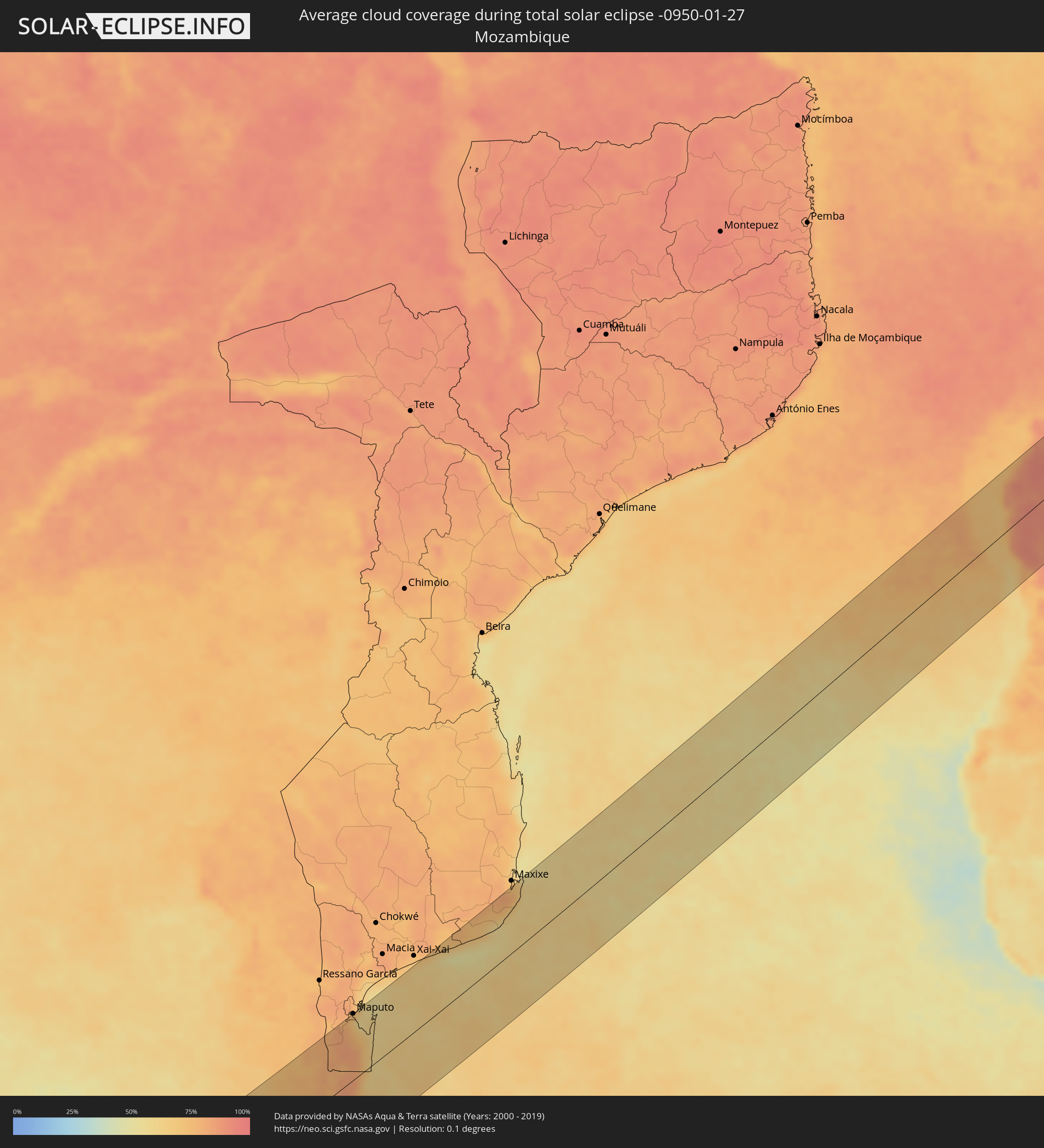 Mozambique
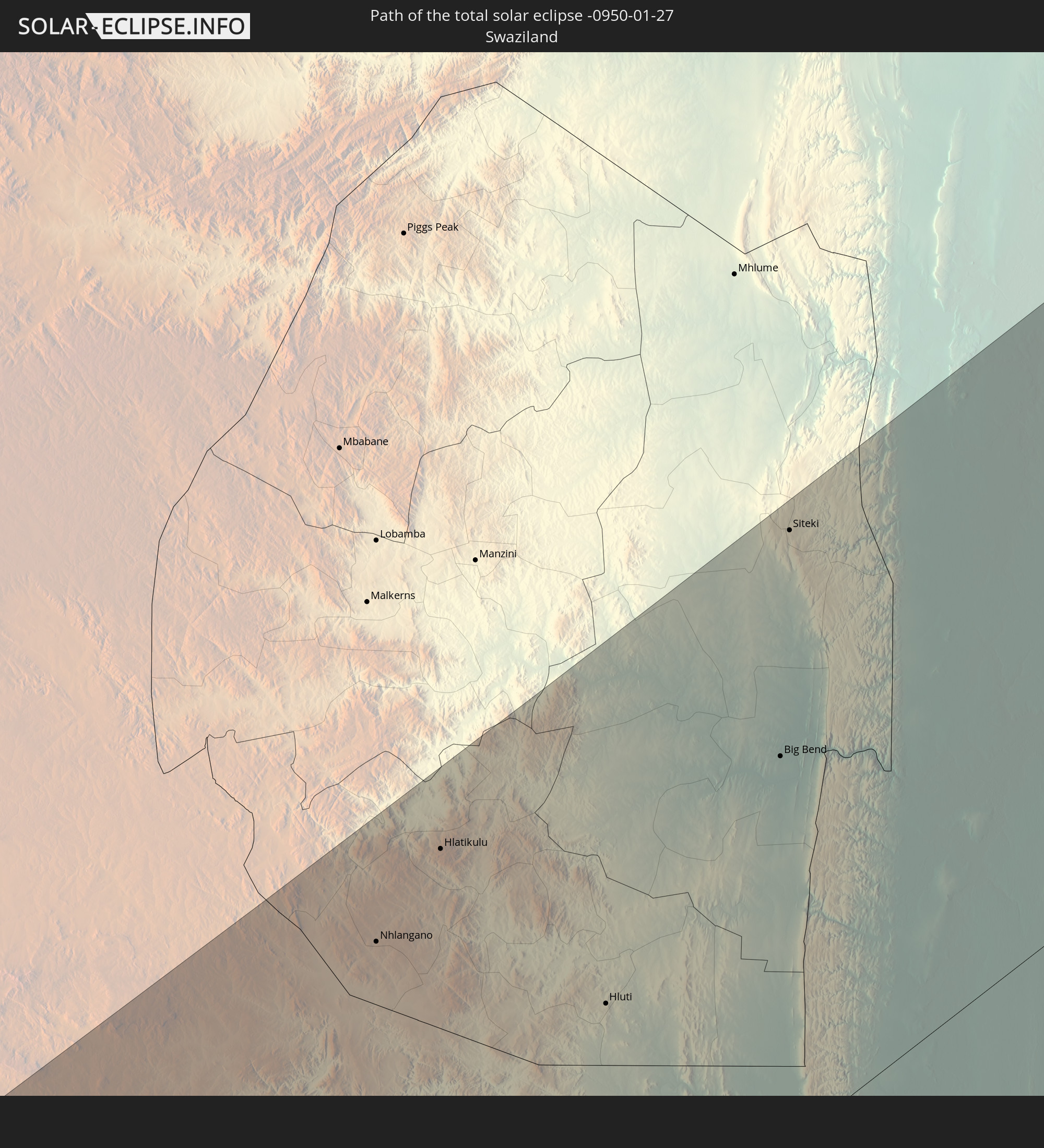
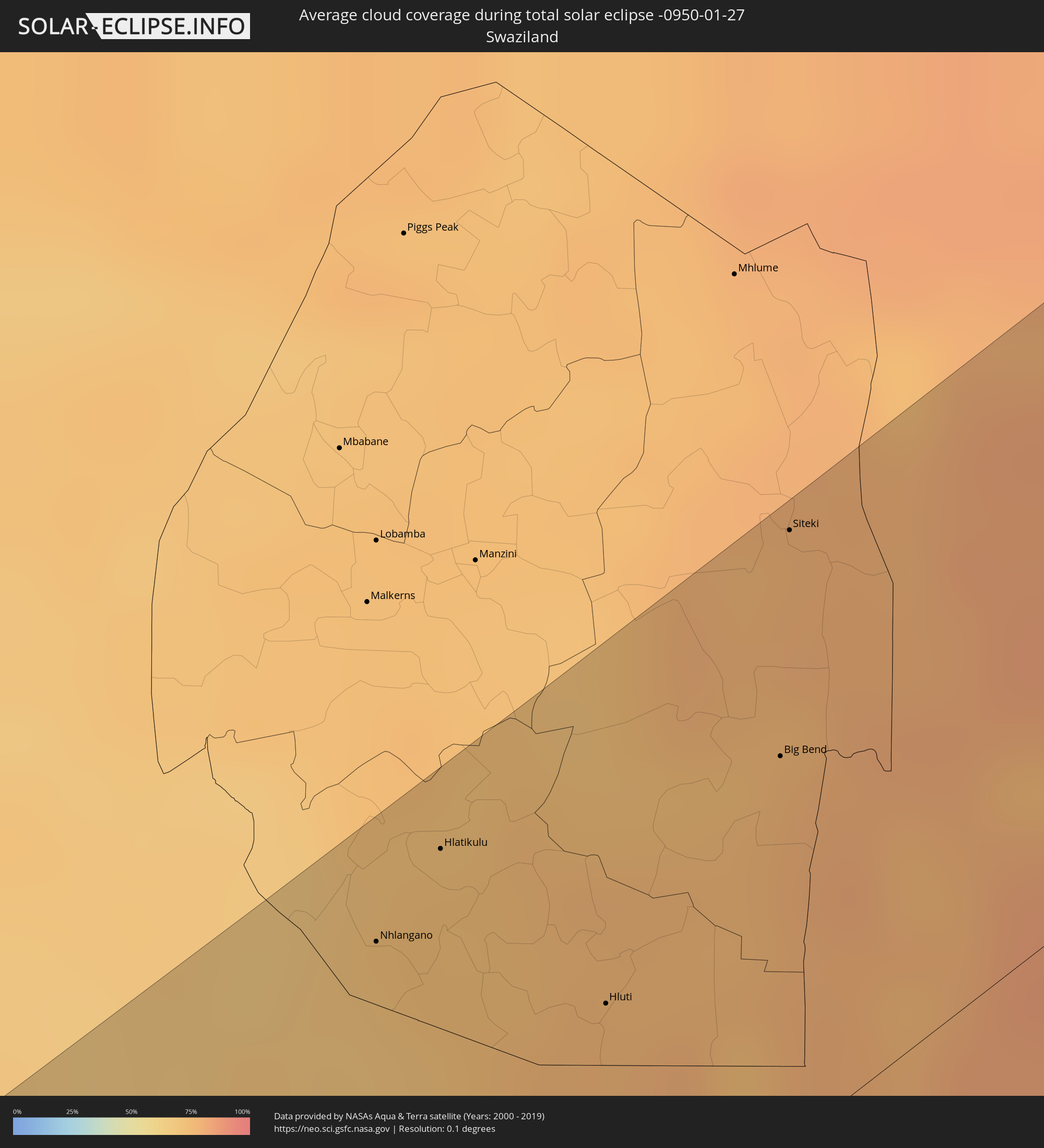 Swaziland
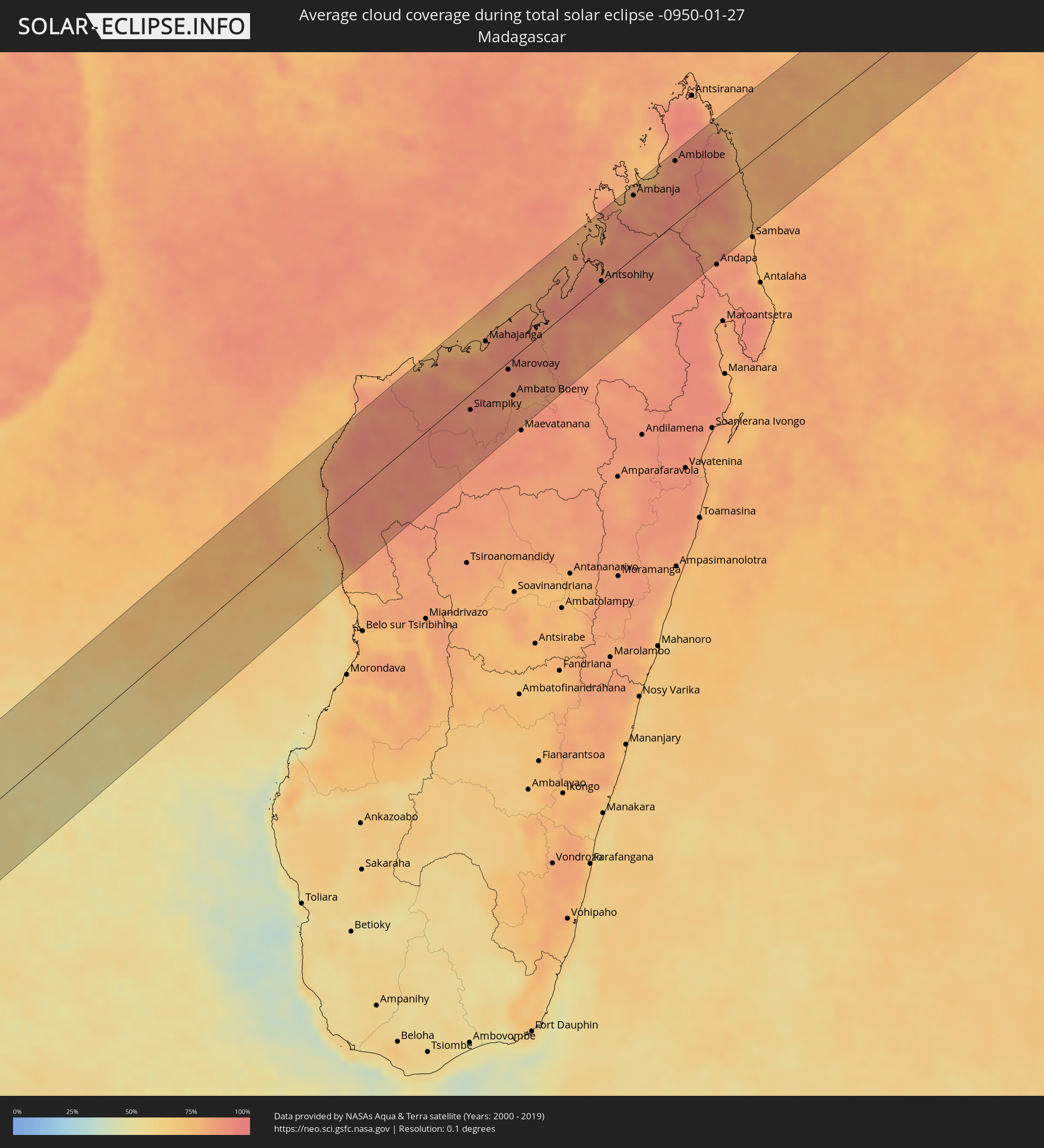 Madagascar
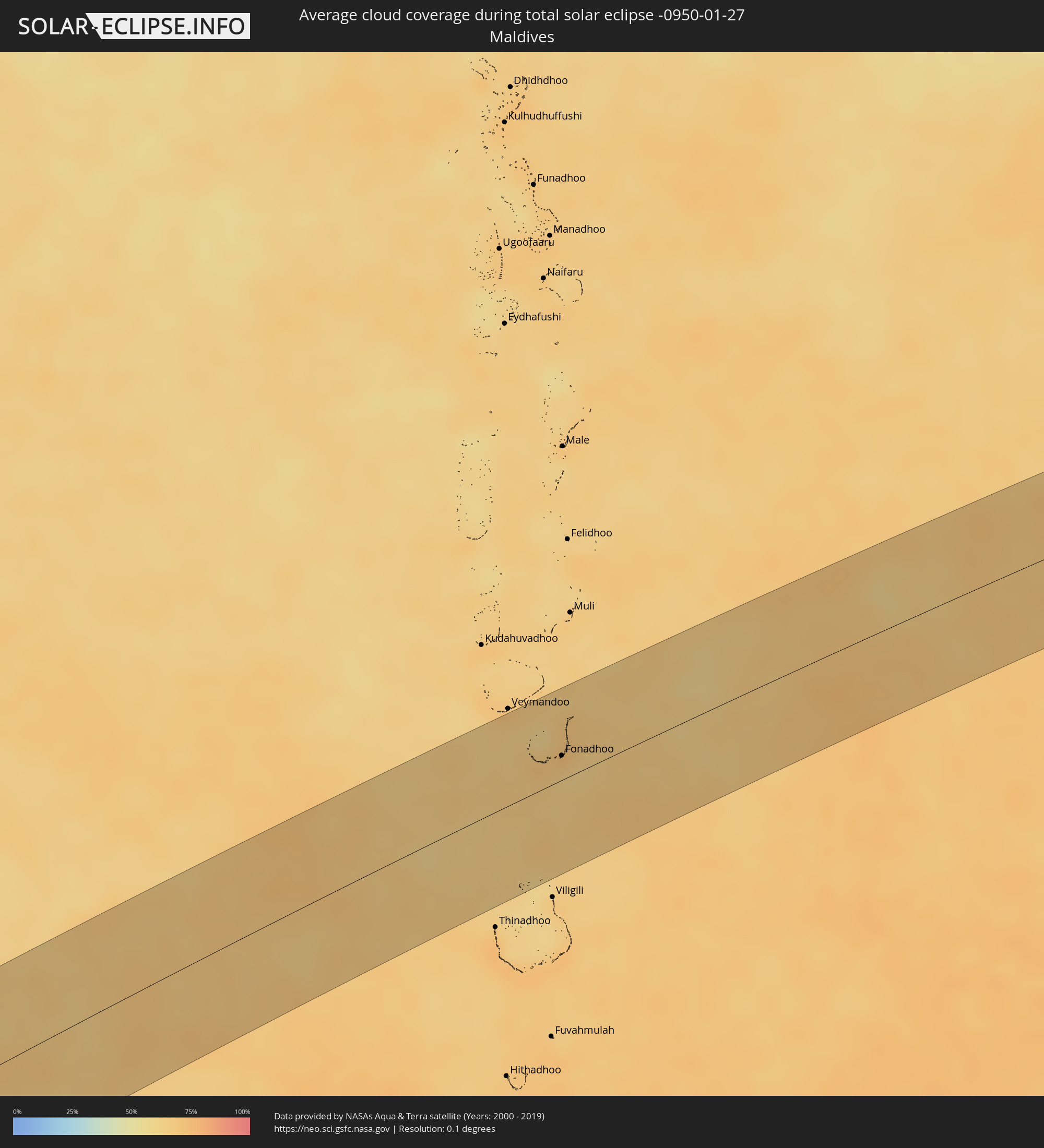 Maldives
Cities inside the path of the eclipse
The following table shows all locations with a population of more than 5,000 inside the eclipse path. Cities which have more than 100,000 inhabitants are marked bold. A click at the locations opens a detailed map.
| City | Type | Eclipse duration | Local time of max. eclipse | Distance to central line | Ø Cloud coverage |
|
Santo Tomé, Corrientes Province
|
total | - | 05:00:52 UTC-04:16 | 64 km | 45% |
|
Gobernador Ingeniero Valentín Virasoro, Corrientes Province
|
total | - | 05:00:35 UTC-04:16 | 13 km | 55% |
|
Posadas, Misiones Province
|
total | - | 05:00:10 UTC-04:16 | 62 km | 56% |
|
Garupá, Misiones Province
|
total | - | 05:00:13 UTC-04:16 | 53 km | 53% |
|
San José, Misiones Province
|
total | - | 05:00:22 UTC-04:16 | 25 km | 55% |
|
Candelaria, Misiones Province
|
total | - | 05:00:11 UTC-04:16 | 58 km | 54% |
|
Concepción de la Sierra, Misiones Province
|
total | - | 05:00:26 UTC-04:16 | 14 km | 52% |
|
Cerro Azul, Misiones Province
|
total | - | 05:00:14 UTC-04:16 | 50 km | 58% |
|
São Luiz Gonzaga, Rio Grande do Sul
|
total | - | 06:10:55 UTC-03:06 | 8 km | 53% |
|
Panambí, Misiones Province
|
total | - | 05:00:11 UTC-04:16 | 64 km | 55% |
|
Santa Rosa, Rio Grande do Sul
|
total | - | 06:10:32 UTC-03:06 | 66 km | 55% |
|
Santo Ângelo, Rio Grande do Sul
|
total | - | 06:10:44 UTC-03:06 | 30 km | 54% |
|
Ijuí, Rio Grande do Sul
|
total | - | 06:10:44 UTC-03:06 | 35 km | 55% |
|
Cruz Alta, Rio Grande do Sul
|
total | - | 06:10:50 UTC-03:06 | 21 km | 55% |
|
Panambi, Rio Grande do Sul
|
total | - | 06:10:37 UTC-03:06 | 61 km | 57% |
|
Candelária, Rio Grande do Sul
|
total | - | 06:11:22 UTC-03:06 | 53 km | 56% |
|
Santa Cruz do Sul, Rio Grande do Sul
|
total | - | 06:11:21 UTC-03:06 | 44 km | 66% |
|
Venâncio Aires, Rio Grande do Sul
|
total | - | 06:11:16 UTC-03:06 | 24 km | 63% |
|
Lajeado, Rio Grande do Sul
|
total | - | 06:11:09 UTC-03:06 | 1 km | 61% |
|
Charqueadas, Rio Grande do Sul
|
total | - | 06:11:26 UTC-03:06 | 38 km | 56% |
|
Bento Gonçalves, Rio Grande do Sul
|
total | - | 06:10:56 UTC-03:06 | 46 km | 64% |
|
Montenegro, Rio Grande do Sul
|
total | - | 06:11:15 UTC-03:06 | 4 km | 58% |
|
Farroupilha, Rio Grande do Sul
|
total | - | 06:10:57 UTC-03:06 | 47 km | 65% |
|
Porto Alegre, Rio Grande do Sul
|
total | - | 06:11:27 UTC-03:06 | 31 km | 63% |
|
Caxias do Sul, Rio Grande do Sul
|
total | - | 06:10:54 UTC-03:06 | 60 km | 67% |
|
Sapucaia, Rio Grande do Sul
|
total | - | 06:11:19 UTC-03:06 | 8 km | 64% |
|
Novo Hamburgo, Rio Grande do Sul
|
total | - | 06:11:13 UTC-03:06 | 9 km | 66% |
|
Viamão, Rio Grande do Sul
|
total | - | 06:11:28 UTC-03:06 | 28 km | 63% |
|
Gravataí, Rio Grande do Sul
|
total | - | 06:11:22 UTC-03:06 | 13 km | 65% |
|
Parobé, Rio Grande do Sul
|
total | - | 06:11:10 UTC-03:06 | 25 km | 61% |
|
Canela, Rio Grande do Sul
|
total | - | 06:11:00 UTC-03:06 | 54 km | 66% |
|
Osório, Rio Grande do Sul
|
total | - | 06:11:18 UTC-03:06 | 20 km | 56% |
|
Tramandaí, Rio Grande do Sul
|
total | - | 06:11:21 UTC-03:06 | 15 km | 56% |
|
Capão da Canoa, Rio Grande do Sul
|
total | - | 06:11:12 UTC-03:06 | 44 km | 57% |
|
Cape Town, Western Cape
|
total | - | 12:14:23 UTC+01:30 | 78 km | 31% |
|
Retreat, Western Cape
|
total | - | 12:14:21 UTC+01:30 | 63 km | 32% |
|
Rondebosch, Western Cape
|
total | - | 12:14:28 UTC+01:30 | 72 km | 31% |
|
Lansdowne, Western Cape
|
total | - | 12:14:29 UTC+01:30 | 69 km | 31% |
|
Kraaifontein, Western Cape
|
total | - | 12:15:05 UTC+01:30 | 74 km | 21% |
|
Stellenbosch, Western Cape
|
total | - | 12:15:18 UTC+01:30 | 60 km | 25% |
|
Paarl, Western Cape
|
total | - | 12:15:45 UTC+01:30 | 75 km | 24% |
|
Grabouw, Western Cape
|
total | - | 12:15:22 UTC+01:30 | 32 km | 35% |
|
Hermanus, Western Cape
|
total | - | 12:15:31 UTC+01:30 | 4 km | 46% |
|
Worcester, Western Cape
|
total | - | 12:16:50 UTC+01:30 | 64 km | 22% |
|
Riversdale, Western Cape
|
total | - | 12:20:00 UTC+01:30 | 57 km | 50% |
|
Oudtshoorn, Western Cape
|
total | - | 12:22:31 UTC+01:30 | 51 km | 31% |
|
Beaufort West, Western Cape
|
total | - | 12:24:55 UTC+01:30 | 52 km | 17% |
|
Graaff-Reinet, Eastern Cape
|
total | - | 12:29:00 UTC+01:30 | 31 km | 28% |
|
Middelburg, Eastern Cape
|
total | - | 12:31:02 UTC+01:30 | 17 km | 32% |
|
Cradock, Eastern Cape
|
total | - | 12:31:16 UTC+01:30 | 77 km | 34% |
|
Aliwal North, Eastern Cape
|
total | - | 12:35:35 UTC+01:30 | 3 km | 35% |
|
Mafeteng, Mafeteng
|
total | - | 12:37:57 UTC+01:30 | 56 km | 47% |
|
Mohale’s Hoek, Mohaleʼs Hoek
|
total | - | 12:37:55 UTC+01:30 | 12 km | 43% |
|
Maseru, Maseru
|
total | - | 12:39:14 UTC+01:30 | 89 km | 52% |
|
Quthing, Quthing
|
total | - | 12:37:58 UTC+01:30 | 23 km | 43% |
|
Teyateyaneng, Berea
|
total | - | 12:40:01 UTC+01:30 | 90 km | 51% |
|
Nako, Maseru
|
total | - | 12:39:19 UTC+01:30 | 46 km | 46% |
|
Thaba-Tseka, Thaba-Tseka
|
total | - | 12:41:05 UTC+01:30 | 8 km | 50% |
|
Qacha’s Nek, Qachaʼs Nek
|
total | - | 12:40:18 UTC+01:30 | 51 km | 45% |
|
Phuthaditjhaba, Orange Free State
|
total | - | 12:43:05 UTC+01:30 | 87 km | 59% |
|
Mokhotlong, Mokhotlong
|
total | - | 12:42:20 UTC+01:30 | 3 km | 48% |
|
Harrismith, Orange Free State
|
total | - | 12:44:06 UTC+01:30 | 92 km | 55% |
|
Newcastle, KwaZulu-Natal
|
total | - | 12:46:29 UTC+01:30 | 92 km | 59% |
|
Howick, KwaZulu-Natal
|
total | - | 12:44:12 UTC+01:30 | 80 km | 67% |
|
Dundee, KwaZulu-Natal
|
total | - | 12:46:22 UTC+01:30 | 37 km | 60% |
|
Mondlo, KwaZulu-Natal
|
total | - | 12:47:34 UTC+01:30 | 25 km | 63% |
|
Vryheid, KwaZulu-Natal
|
total | - | 12:48:04 UTC+01:30 | 40 km | 61% |
|
Nhlangano, Shiselweni
|
total | - | 12:49:55 UTC+01:30 | 74 km | 70% |
|
Hlatikulu, Shiselweni
|
total | - | 12:50:23 UTC+01:30 | 80 km | 74% |
|
Ulundi, KwaZulu-Natal
|
total | - | 12:48:16 UTC+01:30 | 47 km | 76% |
|
Hluti, Shiselweni
|
total | - | 12:50:31 UTC+01:30 | 40 km | 76% |
|
Big Bend, Lubombo
|
total | - | 12:51:46 UTC+01:30 | 56 km | 75% |
|
Siteki, Lubombo
|
total | - | 12:52:25 UTC+01:30 | 87 km | 78% |
|
Maputo, Maputo City
|
total | - | 13:34:44 UTC+02:10 | 91 km | 68% |
|
Maintirano, Melaky
|
total | - | 14:22:53 UTC+02:27 | 6 km | 74% |
|
Mahabe, Melaky
|
total | - | 14:26:06 UTC+02:27 | 1 km | 91% |
|
Sitampiky, Boeny
|
total | - | 14:27:41 UTC+02:27 | 19 km | 88% |
|
Mahajanga, Boeny
|
total | - | 14:29:28 UTC+02:27 | 47 km | 83% |
|
Marovoay, Boeny
|
total | - | 14:29:12 UTC+02:27 | 9 km | 87% |
|
Ambato Boeny, Boeny
|
total | - | 14:28:42 UTC+02:27 | 44 km | 84% |
|
Antsohihy, Sofia
|
total | - | 14:32:37 UTC+02:27 | 3 km | 91% |
|
Ambanja, Diana
|
total | - | 14:34:57 UTC+02:27 | 74 km | 87% |
|
Bealanana, Sofia
|
total | - | 14:33:55 UTC+02:27 | 20 km | 86% |
|
Ambarakaraka, Diana
|
total | - | 14:35:39 UTC+02:27 | 62 km | 90% |
|
Ambilobe, Diana
|
total | - | 14:36:18 UTC+02:27 | 75 km | 86% |
|
Ambodivoara, Sava
|
total | - | 14:35:27 UTC+02:27 | 87 km | 83% |
|
Fonadhoo, Laamu
|
total | - | 17:31:28 UTC+04:54 | 19 km | 66% |