Total solar eclipse of 04/09/-1019
| Day of week: | Saturday |
| Maximum duration of eclipse: | 06m26s |
| Maximum width of eclipse path: | 259 km |
| Saros cycle: | 32 |
| Coverage: | 100% |
| Magnitude: | 1.0763 |
| Gamma: | 0.3091 |
Wo kann man die Sonnenfinsternis vom 04/09/-1019 sehen?
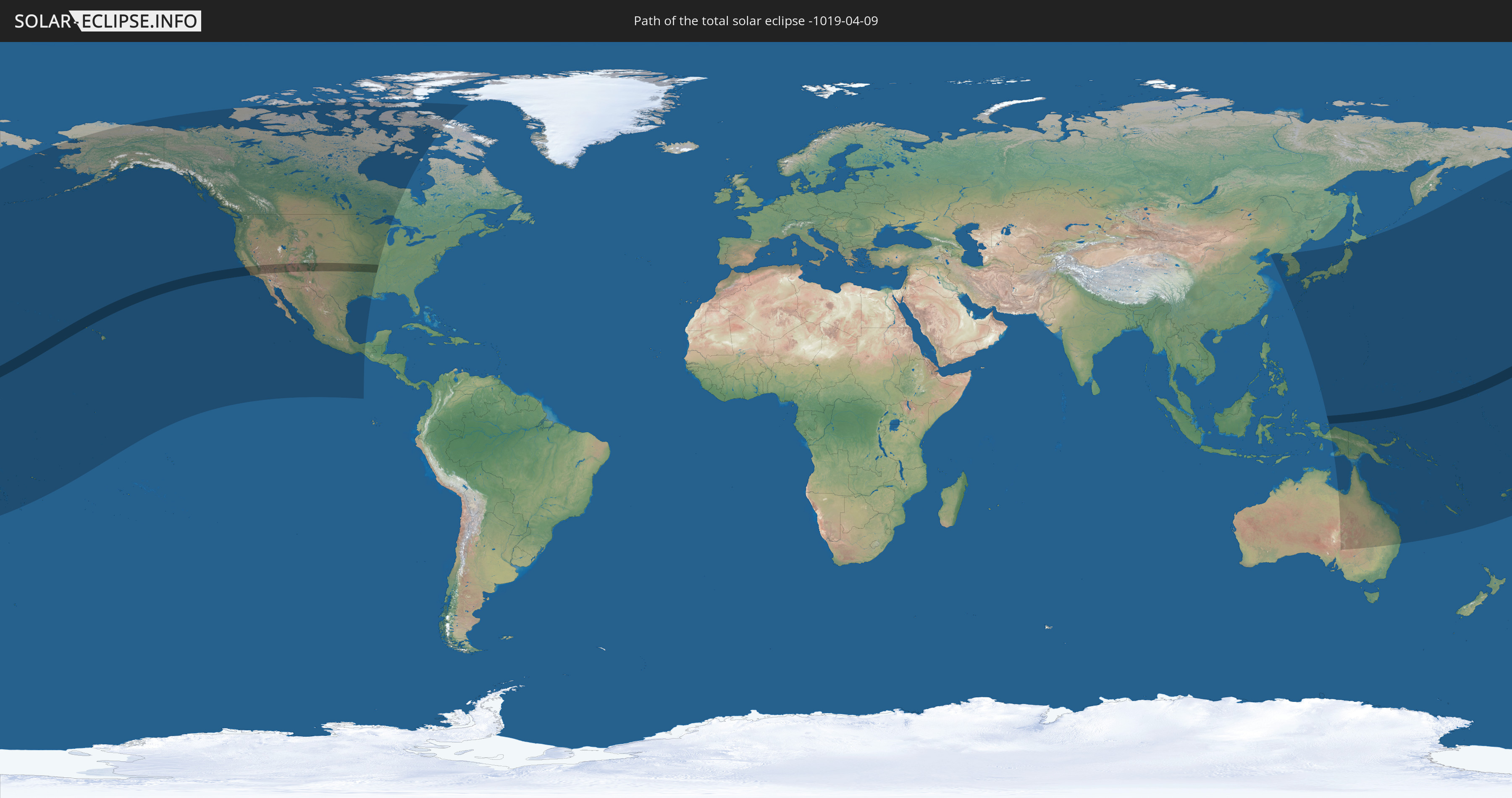
Die Sonnenfinsternis am 04/09/-1019 kann man in 31 Ländern als partielle Sonnenfinsternis beobachten.
Der Finsternispfad verläuft durch 4 Länder. Nur in diesen Ländern ist sie als total Sonnenfinsternis zu sehen.
In den folgenden Ländern ist die Sonnenfinsternis total zu sehen
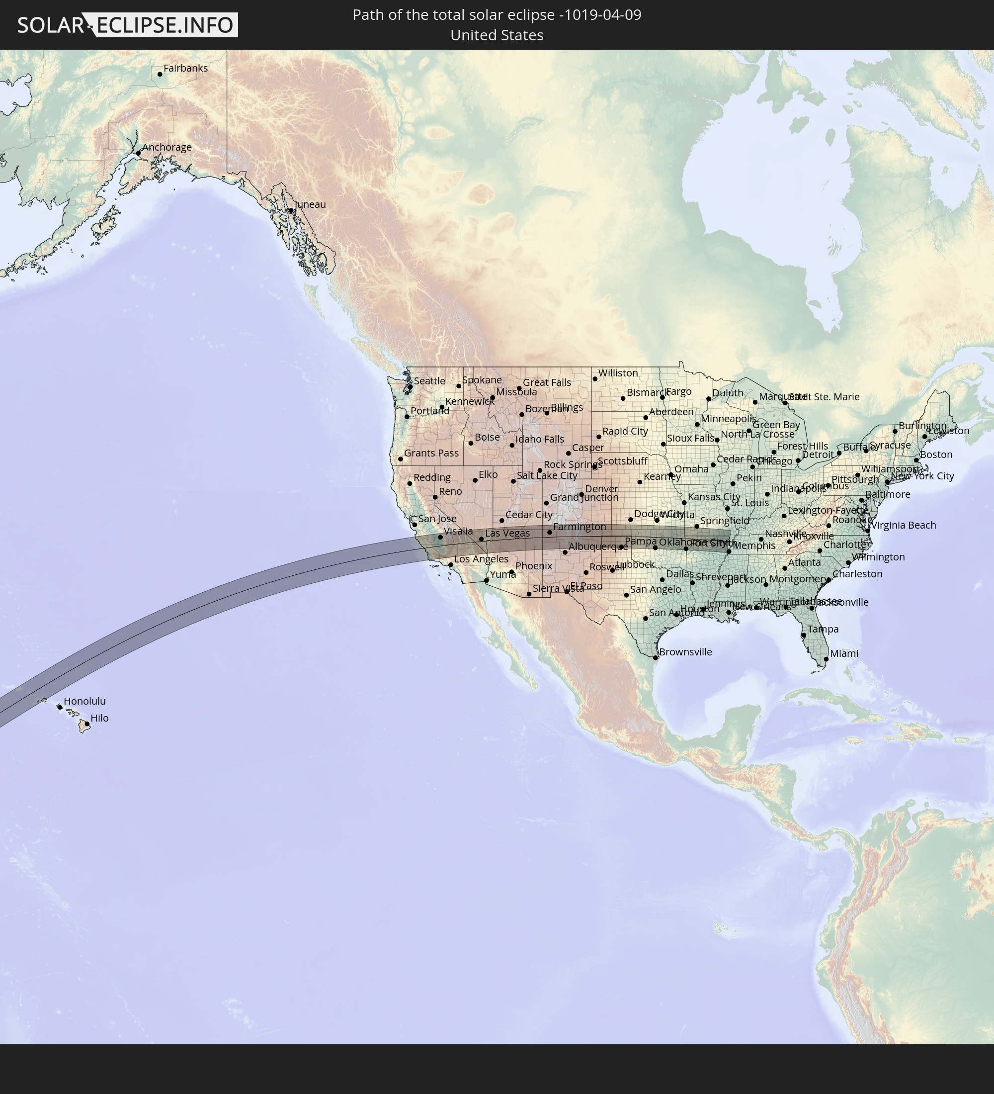 United States
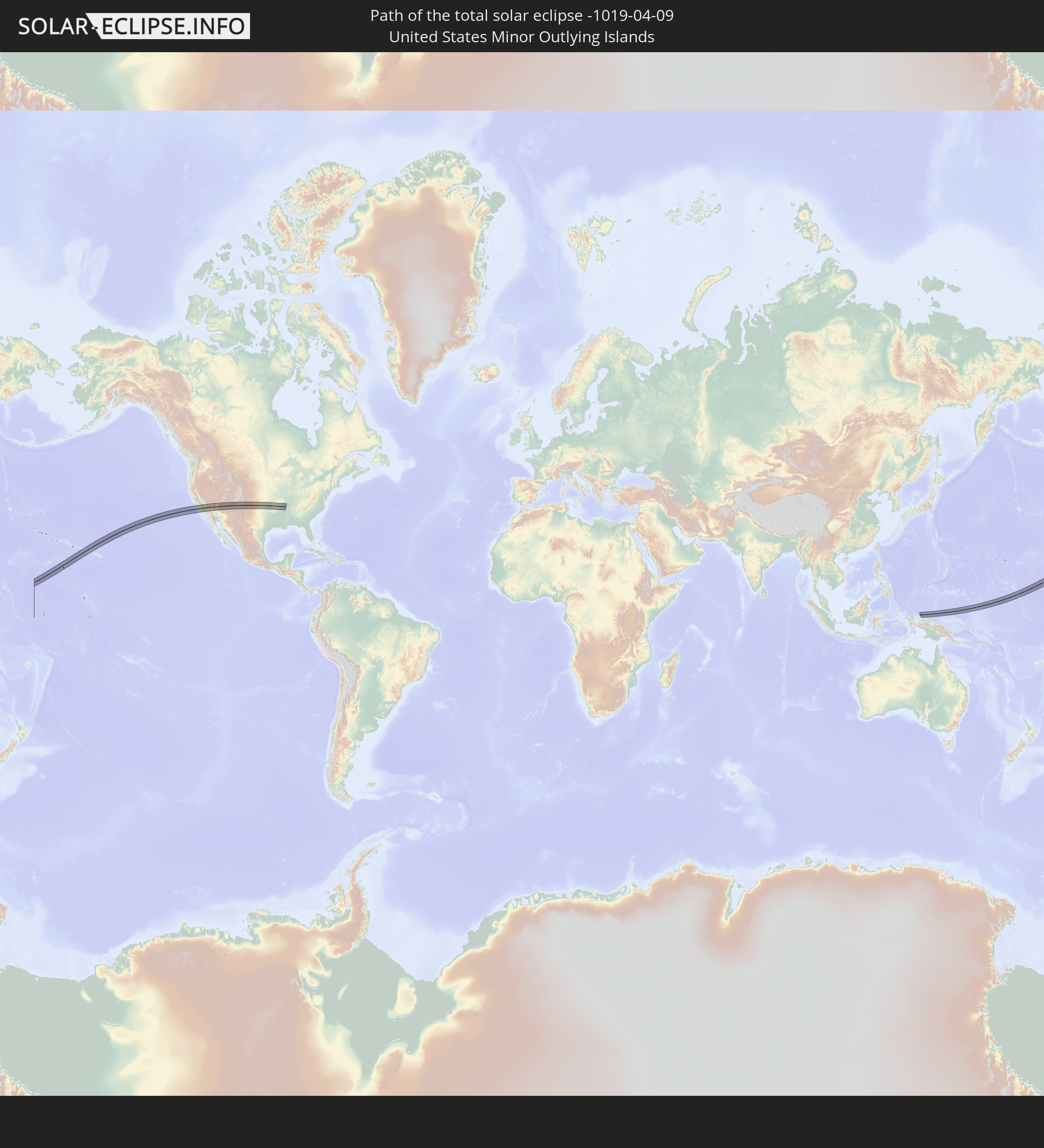 United States Minor Outlying Islands
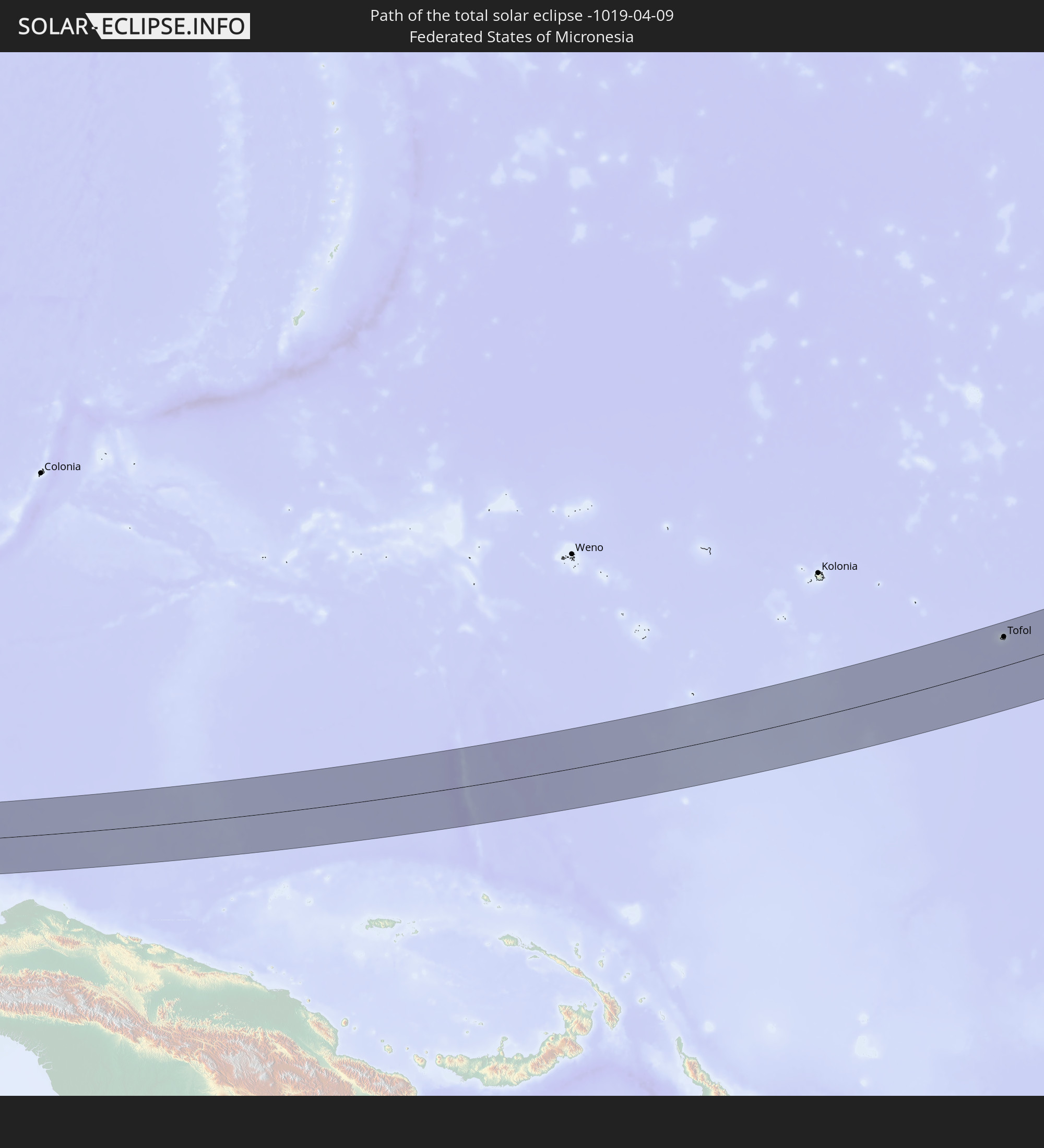 Federated States of Micronesia
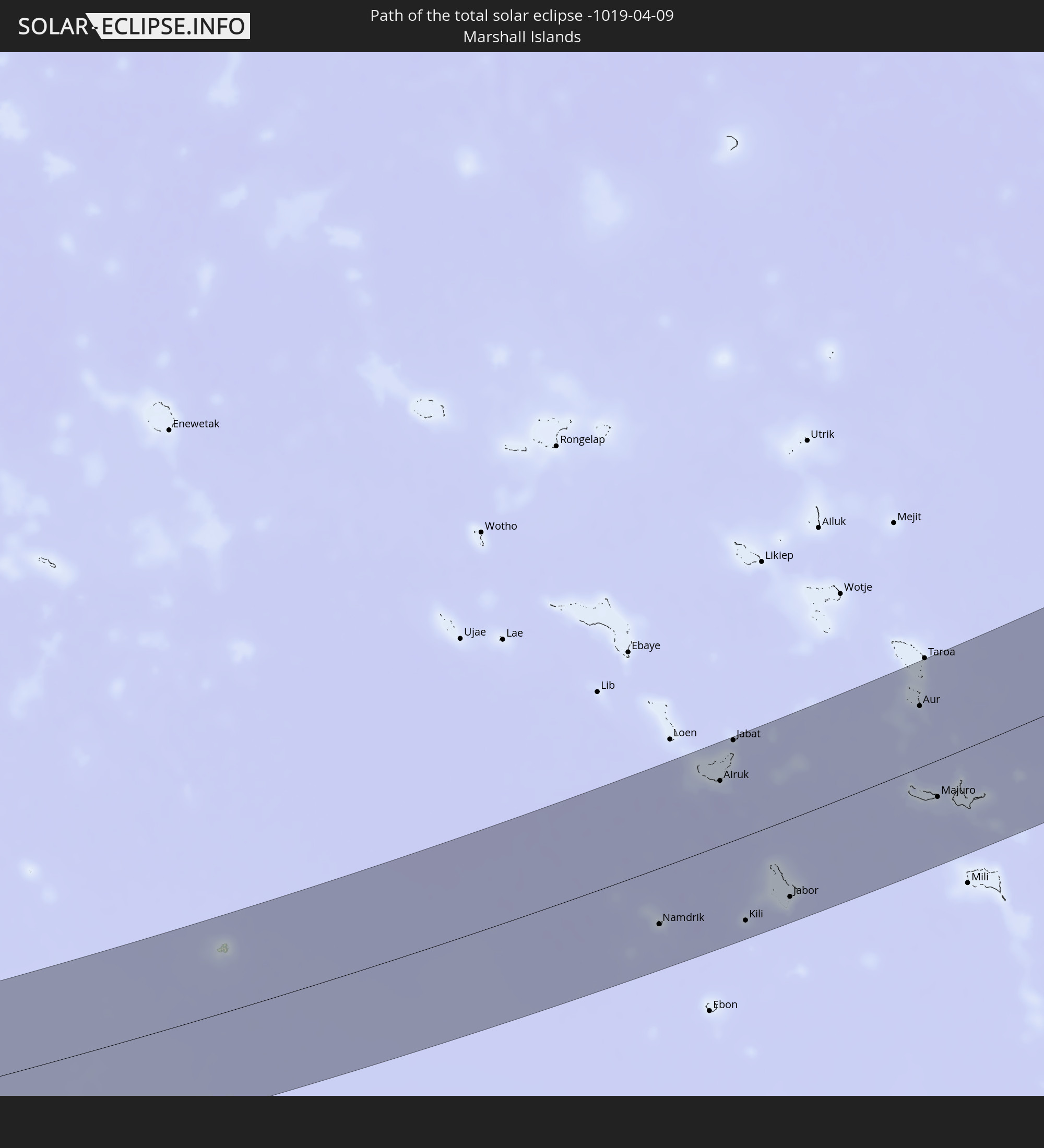 Marshall Islands
In den folgenden Ländern ist die Sonnenfinsternis partiell zu sehen
 Fiji
Fiji
 Russia
 United States
 United States Minor Outlying Islands
 Wallis and Futuna
 Tonga
Tonga
 Kiribati
 Samoa
Samoa
 Tokelau
 American Samoa
 Cook Islands
 Canada
 Mexico
 Greenland
 China
China
 Indonesia
 Australia
 Japan
Japan
 North Korea
 South Korea
 Palau
Palau
 Federated States of Micronesia
 Papua New Guinea
 Guam
Guam
 Northern Mariana Islands
 Solomon Islands
 New Caledonia
 Marshall Islands
 Vanuatu
 Nauru
Nauru
 Tuvalu
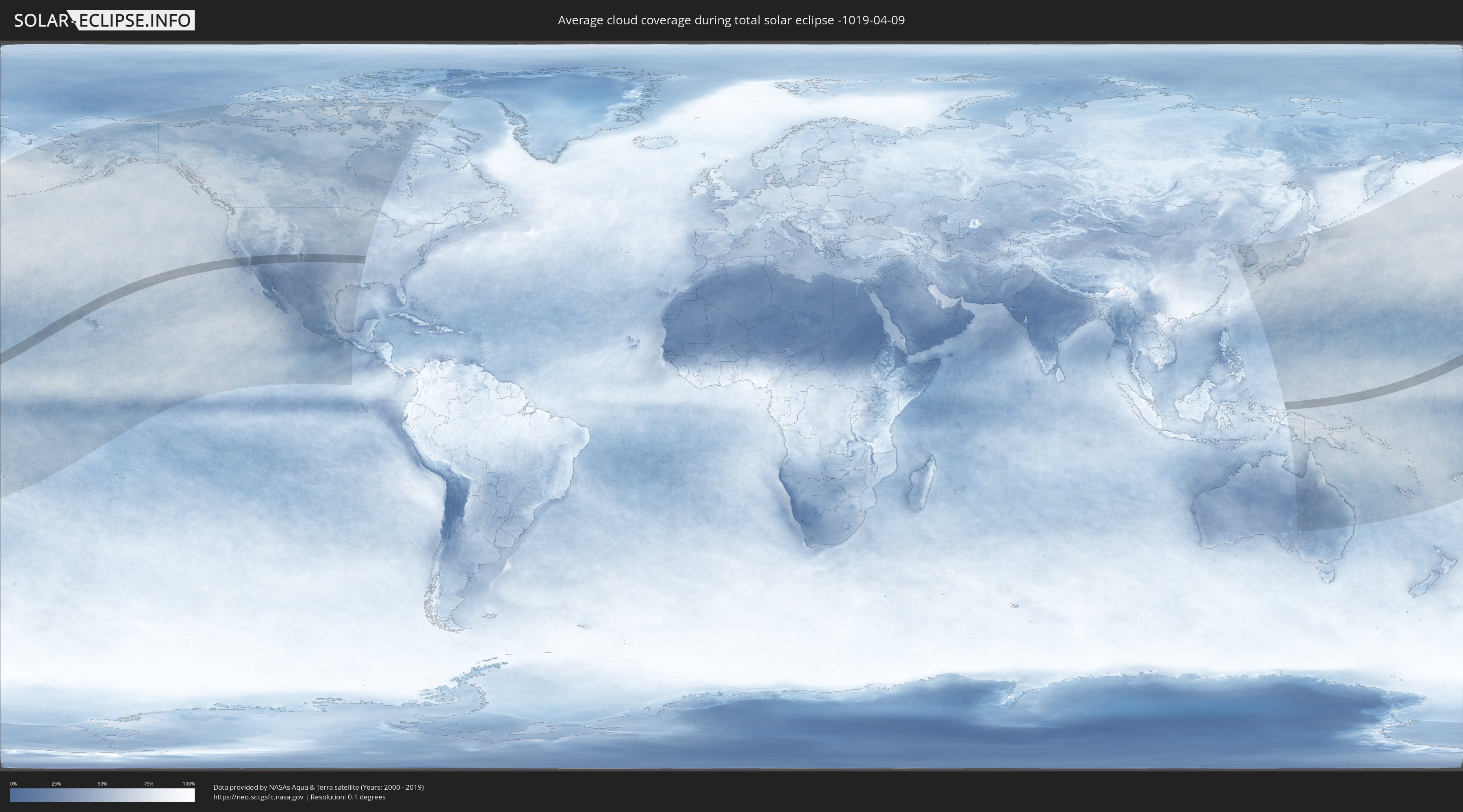
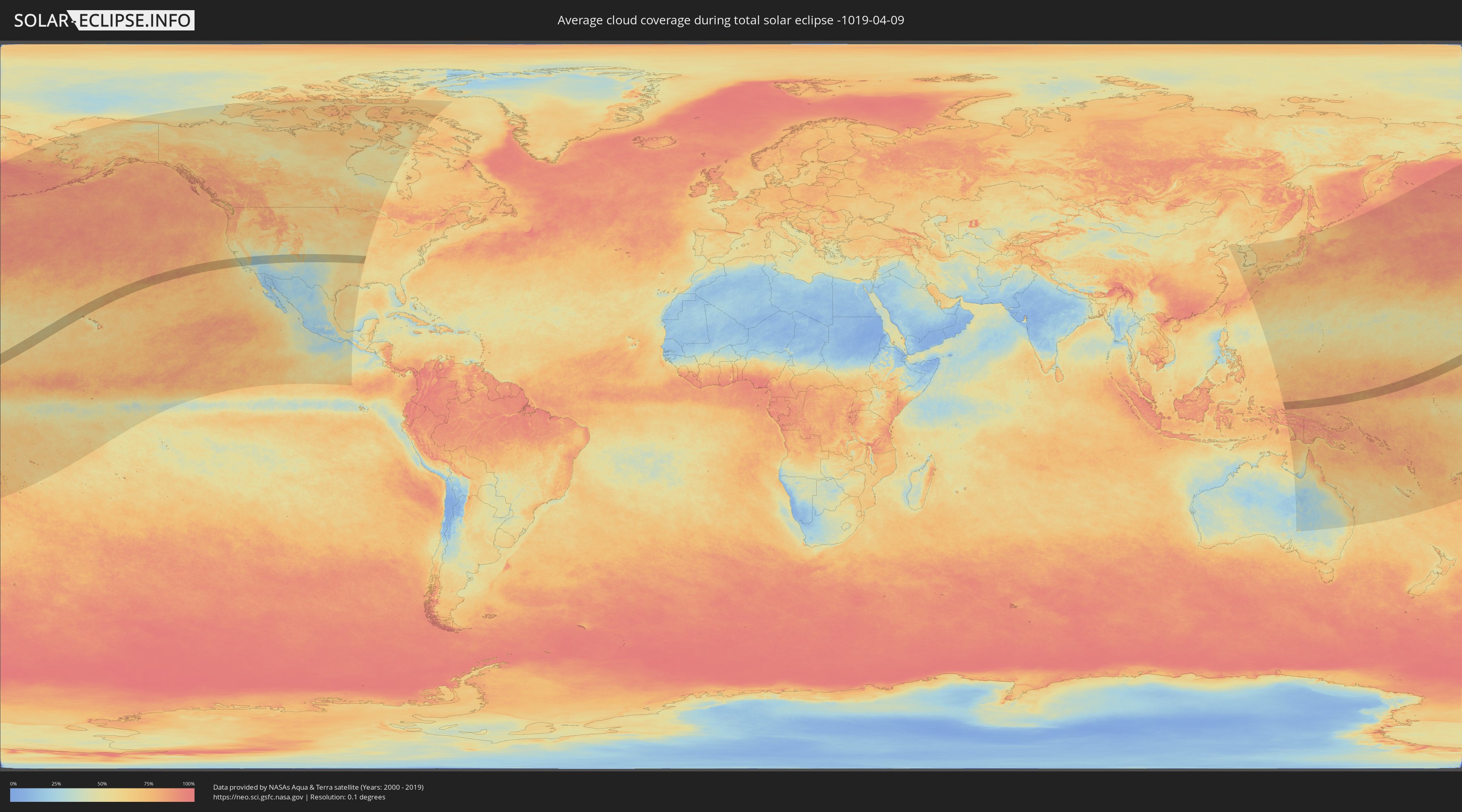
How will be the weather during the total solar eclipse on 04/09/-1019?
Where is the best place to see the total solar eclipse of 04/09/-1019?
The following maps show the average cloud coverage for the day of the total solar eclipse.
With the help of these maps, it is possible to find the place along the eclipse path, which has the best
chance of a cloudless sky.
Nevertheless, you should consider local circumstances and inform about the weather of your chosen
observation site.
The data is provided by NASAs satellites
AQUA and TERRA.
The cloud maps are averaged over a period of 19 years (2000 - 2019).
Detailed country maps
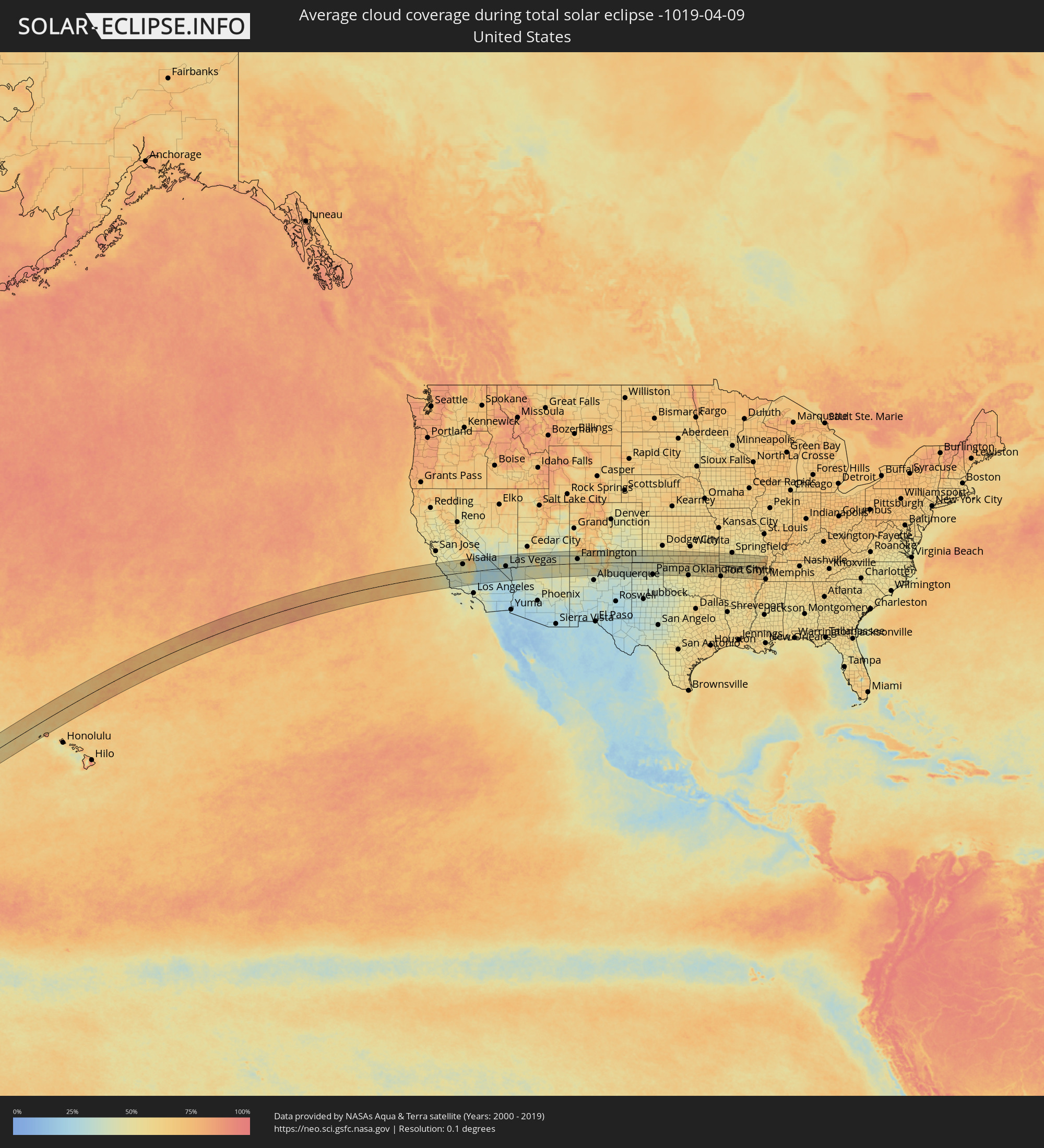 United States
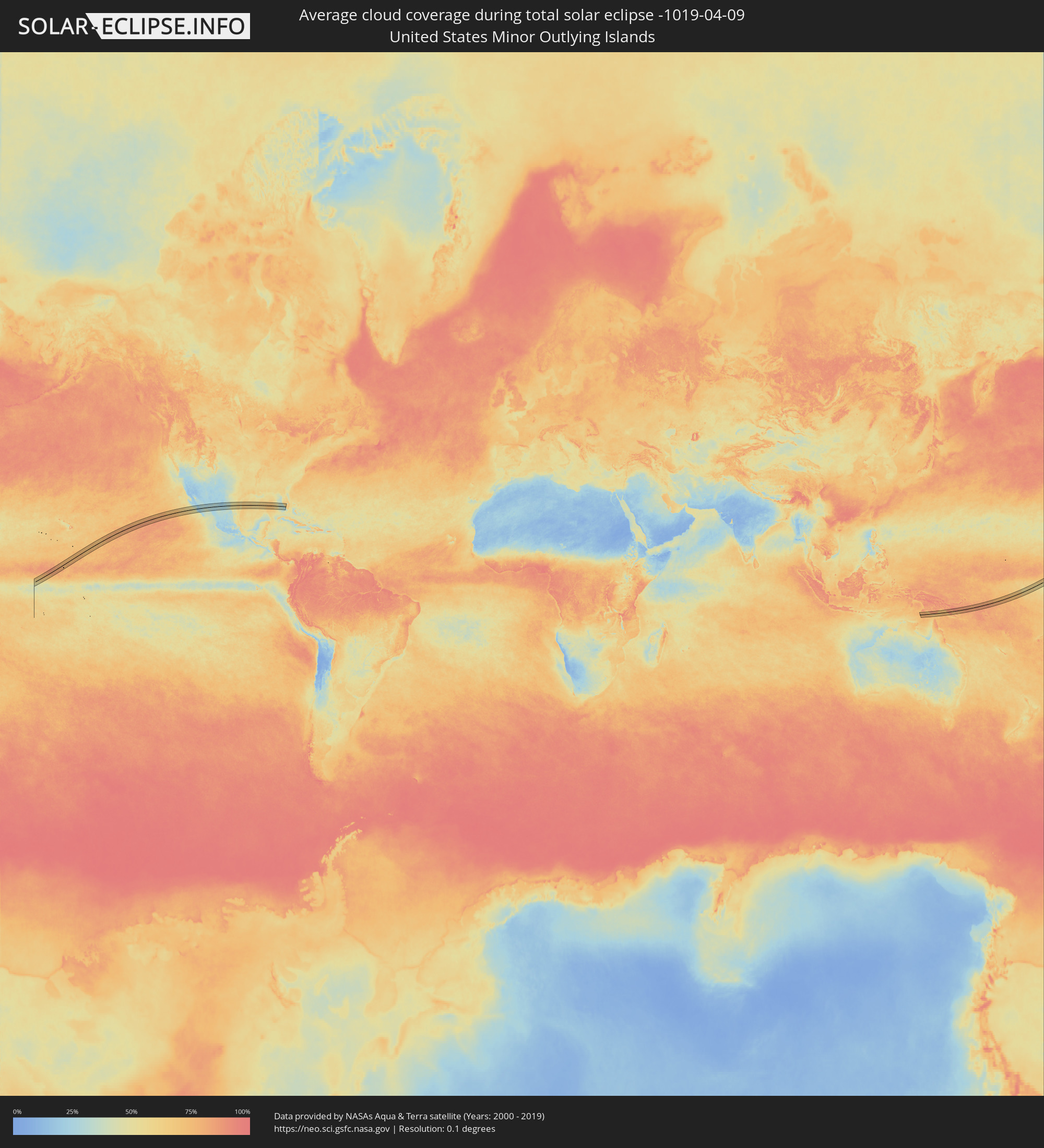 United States Minor Outlying Islands
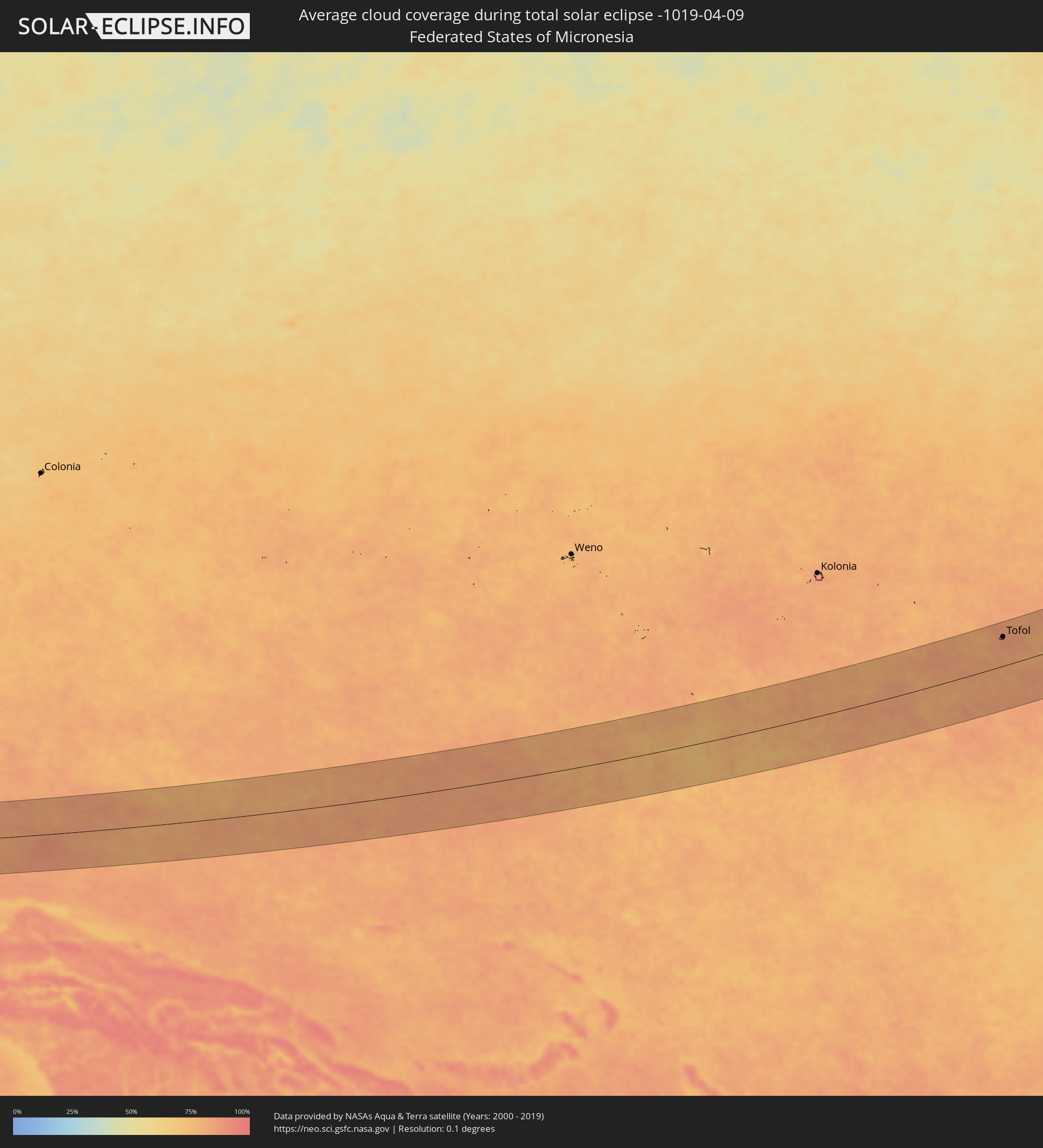 Federated States of Micronesia
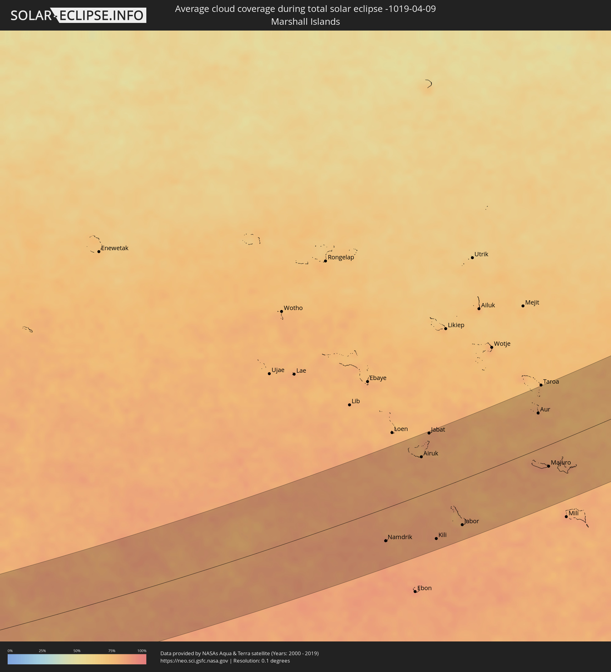 Marshall Islands
Cities inside the path of the eclipse
The following table shows all locations with a population of more than 5,000 inside the eclipse path. Cities which have more than 100,000 inhabitants are marked bold. A click at the locations opens a detailed map.
| City | Type | Eclipse duration | Local time of max. eclipse | Distance to central line | Ø Cloud coverage |
|
Soledad, California
|
total | - | 16:01:38 UTC-08:00 | 106 km | 45% |
|
Los Osos, California
|
total | - | 16:02:31 UTC-08:00 | 23 km | 40% |
|
Paso Robles, California
|
total | - | 16:02:31 UTC-08:00 | 10 km | 44% |
|
Atascadero, California
|
total | - | 16:02:35 UTC-08:00 | 5 km | 42% |
|
San Luis Obispo, California
|
total | - | 16:02:40 UTC-08:00 | 28 km | 39% |
|
Arroyo Grande, California
|
total | - | 16:02:48 UTC-08:00 | 47 km | 41% |
|
Lompoc, California
|
total | - | 16:03:05 UTC-08:00 | 102 km | 43% |
|
Santa Maria, California
|
total | - | 16:03:00 UTC-08:00 | 67 km | 44% |
|
Avenal, California
|
total | - | 16:02:52 UTC-08:00 | 45 km | 44% |
|
Hanford, California
|
total | - | 16:03:09 UTC-08:00 | 75 km | 48% |
|
Corcoran, California
|
total | - | 16:03:19 UTC-08:00 | 49 km | 44% |
|
Reedley, California
|
total | - | 16:03:11 UTC-08:00 | 102 km | 53% |
|
Wasco, California
|
total | - | 16:03:42 UTC-08:00 | 10 km | 44% |
|
Visalia, California
|
total | - | 16:03:26 UTC-08:00 | 71 km | 48% |
|
Delano, California
|
total | - | 16:03:43 UTC-08:00 | 9 km | 46% |
|
Bakersfield, California
|
total | - | 16:04:04 UTC-08:00 | 38 km | 48% |
|
Porterville, California
|
total | - | 16:03:47 UTC-08:00 | 39 km | 49% |
|
Arvin, California
|
total | - | 16:04:17 UTC-08:00 | 58 km | 49% |
|
Tehachapi, California
|
total | - | 16:04:38 UTC-08:00 | 70 km | 43% |
|
Rosamond, California
|
total | - | 16:04:58 UTC-08:00 | 103 km | 31% |
|
California City, California
|
total | - | 16:05:01 UTC-08:00 | 76 km | 28% |
|
Ridgecrest, California
|
total | - | 16:05:03 UTC-08:00 | 24 km | 26% |
|
Barstow, California
|
total | - | 16:05:52 UTC-08:00 | 111 km | 27% |
|
Pahrump, Nevada
|
total | - | 16:06:04 UTC-08:00 | 25 km | 31% |
|
Enterprise, Nevada
|
total | - | 16:06:40 UTC-08:00 | 2 km | 31% |
|
Las Vegas, Nevada
|
total | - | 16:06:40 UTC-08:00 | 14 km | 35% |
|
Henderson, Nevada
|
total | - | 16:06:51 UTC-08:00 | 2 km | 29% |
|
Boulder City, Nevada
|
total | - | 16:06:59 UTC-08:00 | 10 km | 30% |
|
Bullhead City, Arizona
|
total | - | 17:07:33 UTC-07:00 | 104 km | 34% |
|
Mesquite, Nevada
|
total | - | 16:07:04 UTC-08:00 | 76 km | 35% |
|
Kingman, Arizona
|
total | - | 17:07:52 UTC-07:00 | 104 km | 35% |
|
Saint George, Utah
|
total | - | 17:07:14 UTC-07:00 | 105 km | 36% |
|
Gallup, New Mexico
|
total | - | 17:10:46 UTC-07:00 | 95 km | 46% |
|
Farmington, New Mexico
|
total | - | 17:10:21 UTC-07:00 | 37 km | 42% |
|
Durango, Colorado
|
total | - | 17:10:12 UTC-07:00 | 97 km | 51% |
|
Santa Fe, New Mexico
|
total | - | 17:11:55 UTC-07:00 | 85 km | 47% |
|
Dumas, Texas
|
total | - | 18:13:09 UTC-06:00 | 67 km | 41% |
|
Pampa, Texas
|
total | - | 18:13:36 UTC-06:00 | 103 km | 42% |
|
Liberal, Kansas
|
total | - | 18:12:43 UTC-06:00 | 65 km | 47% |
|
El Reno, Oklahoma
|
total | - | 18:14:14 UTC-06:00 | 97 km | 51% |
|
Enid, Oklahoma
|
total | - | 18:13:44 UTC-06:00 | 0 km | 59% |
|
Yukon, Oklahoma
|
total | - | 18:14:16 UTC-06:00 | 99 km | 53% |
|
Oklahoma City, Oklahoma
|
total | - | 18:14:20 UTC-06:00 | 102 km | 54% |
|
Edmond, Oklahoma
|
total | - | 18:14:14 UTC-06:00 | 82 km | 54% |
|
Ponca City, Oklahoma
|
total | - | 18:13:40 UTC-06:00 | 37 km | 57% |
|
Stillwater, Oklahoma
|
total | - | 18:14:01 UTC-06:00 | 29 km | 51% |
|
Sapulpa, Oklahoma
|
total | - | 18:14:13 UTC-06:00 | 38 km | 54% |
|
Tulsa, Oklahoma
|
total | - | 18:14:08 UTC-06:00 | 21 km | 56% |
|
Bartlesville, Oklahoma
|
total | - | 18:13:46 UTC-06:00 | 45 km | 57% |
|
Owasso, Oklahoma
|
total | - | 18:14:05 UTC-06:00 | 7 km | 58% |
|
Broken Arrow, Oklahoma
|
total | - | 18:14:13 UTC-06:00 | 31 km | 60% |
|
Claremore, Oklahoma
|
total | - | 18:14:04 UTC-06:00 | 1 km | 60% |
|
Muskogee, Oklahoma
|
total | - | 18:14:26 UTC-06:00 | 63 km | 63% |
|
Tahlequah, Oklahoma
|
total | - | 18:14:22 UTC-06:00 | 43 km | 60% |
|
Siloam Springs, Arkansas
|
total | - | 18:14:15 UTC-06:00 | 10 km | 59% |
|
Joplin, Missouri
|
total | - | 18:13:42 UTC-06:00 | 89 km | 54% |
|
Fort Smith, Arkansas
|
total | - | 18:14:44 UTC-06:00 | 99 km | 62% |
|
Carthage, Missouri
|
total | - | 18:13:39 UTC-06:00 | 101 km | 57% |
|
Bella Vista, Arkansas
|
total | - | 18:14:05 UTC-06:00 | 23 km | 56% |
|
Fayetteville, Arkansas
|
total | - | 18:14:21 UTC-06:00 | 22 km | 61% |
|
Rogers, Arkansas
|
total | - | 18:14:11 UTC-06:00 | 8 km | 60% |
|
Republic, Missouri
|
total | - | 18:13:44 UTC-06:00 | 99 km | 54% |
|
Nixa, Missouri
|
total | - | 18:13:47 UTC-06:00 | 91 km | 52% |
|
Searcy, Arkansas
|
total | - | 18:14:54 UTC-06:00 | 99 km | 61% |
|
Jonesboro, Arkansas
|
total | - | 18:14:32 UTC-06:00 | 27 km | 70% |
|
Paragould, Arkansas
|
total | - | 18:14:24 UTC-06:00 | 1 km | 67% |
|
Poplar Bluff, Missouri
|
total | - | 18:13:59 UTC-06:00 | 77 km | 63% |
|
Tofol, Kosrae
|
total | - | 08:15:26 UTC+11:00 | 80 km | 83% |
|
Namdrik, Namdrik Atoll
|
total | - | 08:21:29 UTC+11:00 | 69 km | 84% |
|
Airuk, Ailinglaplap Atoll
|
total | - | 08:24:27 UTC+11:00 | 79 km | 81% |
|
Jabat, Jabat Island
|
total | - | 08:25:15 UTC+11:00 | 122 km | 82% |
|
Kili, Kili Island
|
total | - | 08:22:49 UTC+11:00 | 103 km | 82% |
|
Jabor, Jaluit Atoll
|
total | - | 08:23:50 UTC+11:00 | 95 km | 82% |
|
Aur, Aur Atoll
|
total | - | 08:28:46 UTC+11:00 | 74 km | 79% |
|
Majuro, Majuro Atoll
|
total | - | 08:27:41 UTC+11:00 | 44 km | 83% |
|
RMI Capitol, Majuro Atoll
|
total | - | 08:27:41 UTC+11:00 | 44 km | 83% |
|
Arno, Arno Atoll
|
total | - | 08:27:54 UTC+11:00 | 54 km | 80% |