Total solar eclipse of 06/20/-1069
| Day of week: | Monday |
| Maximum duration of eclipse: | 04m16s |
| Maximum width of eclipse path: | 155 km |
| Saros cycle: | 39 |
| Coverage: | 100% |
| Magnitude: | 1.0463 |
| Gamma: | 0.0736 |
Wo kann man die Sonnenfinsternis vom 06/20/-1069 sehen?
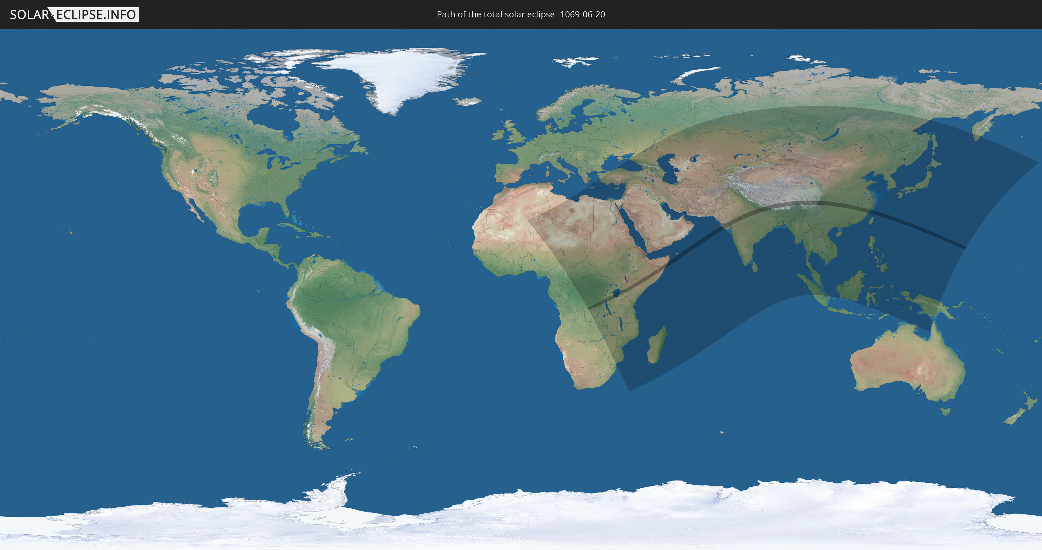
Die Sonnenfinsternis am 06/20/-1069 kann man in 92 Ländern als partielle Sonnenfinsternis beobachten.
Der Finsternispfad verläuft durch 13 Länder. Nur in diesen Ländern ist sie als total Sonnenfinsternis zu sehen.
In den folgenden Ländern ist die Sonnenfinsternis total zu sehen
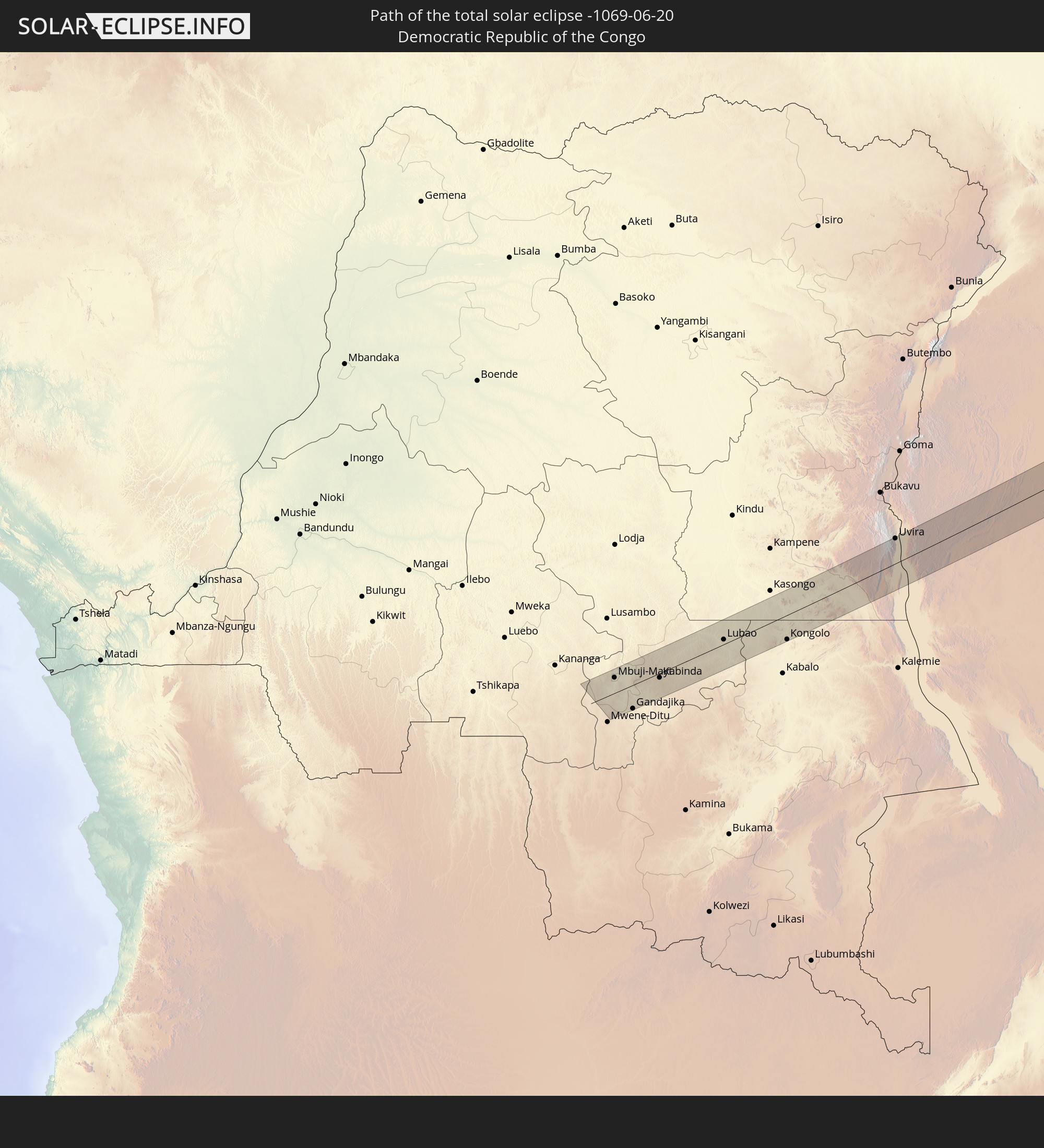 Democratic Republic of the Congo
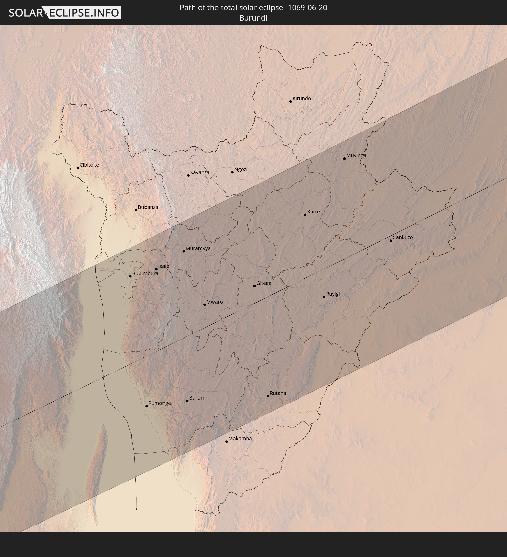 Burundi
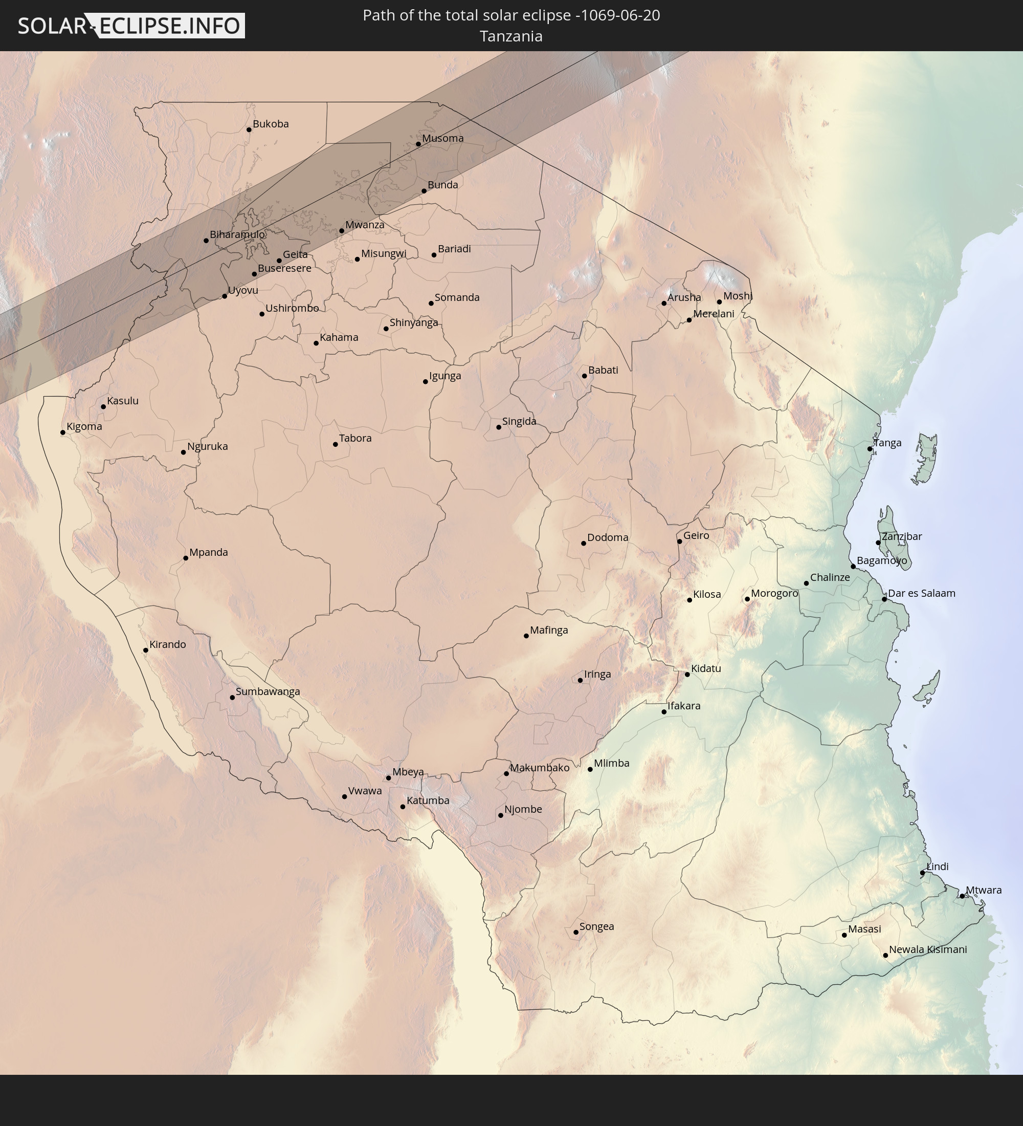 Tanzania
 Uganda
 Ethiopia
 Kenya
Kenya
 Somalia
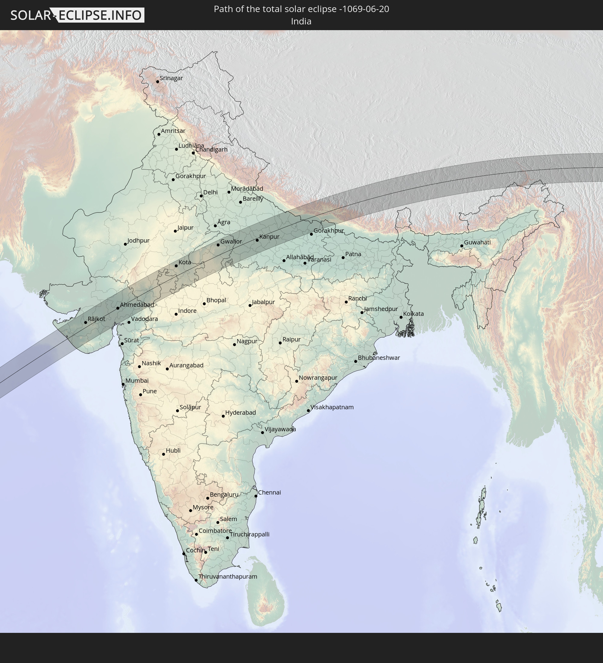 India
India
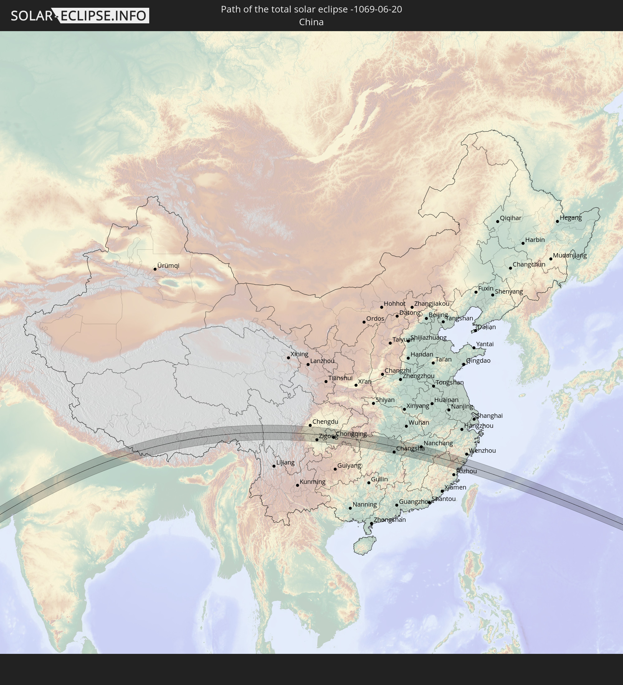 China
China
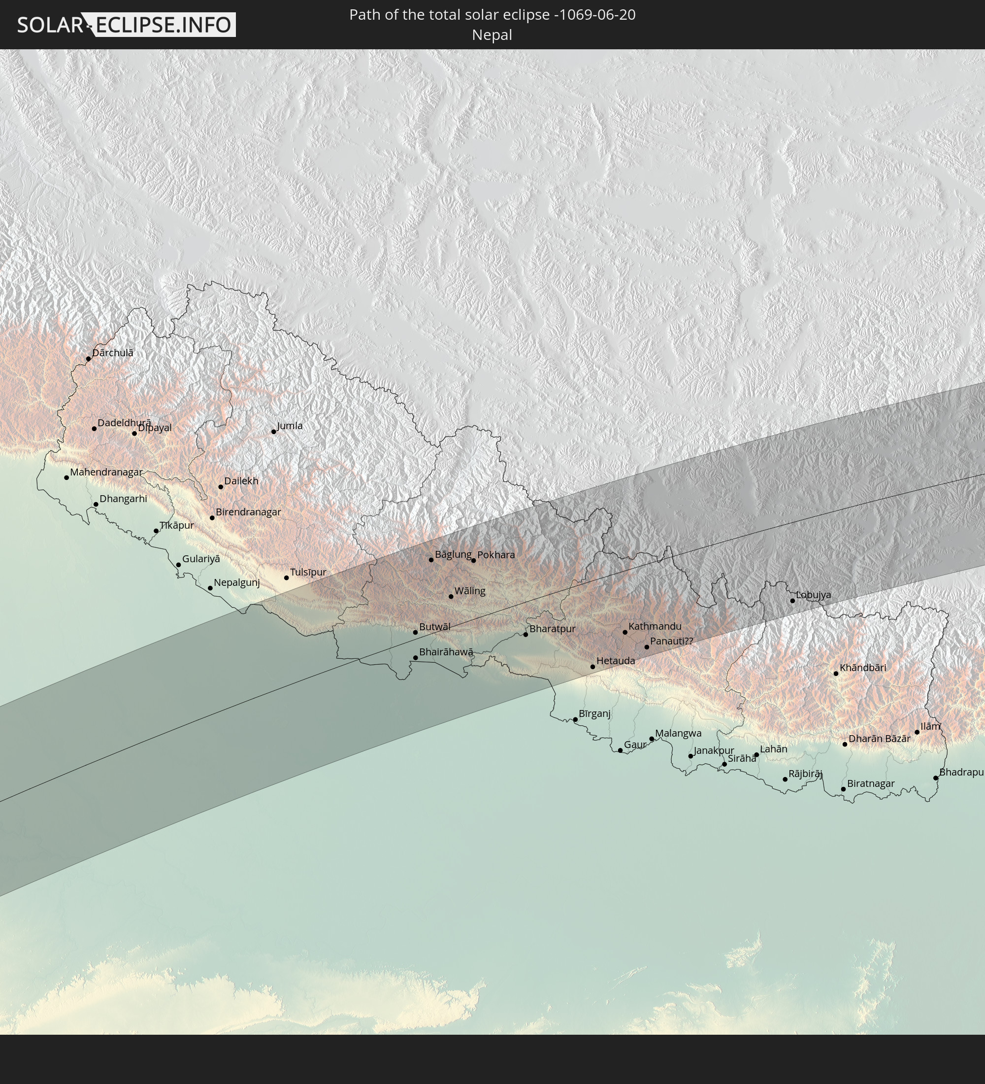 Nepal
Nepal
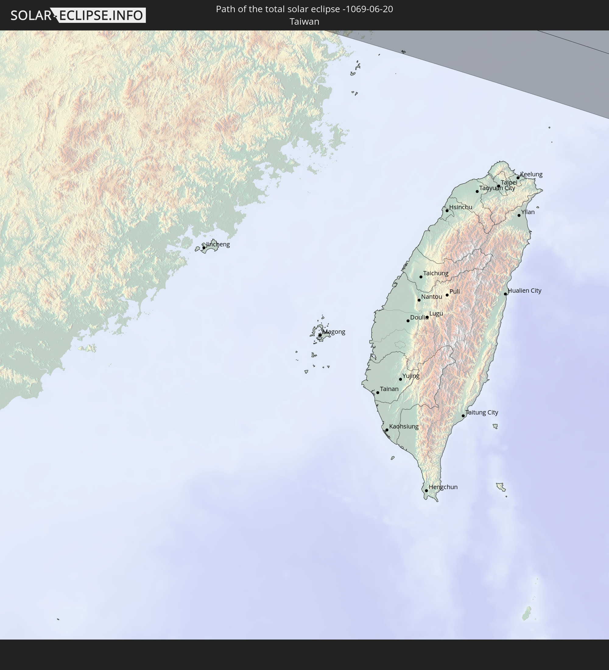 Taiwan
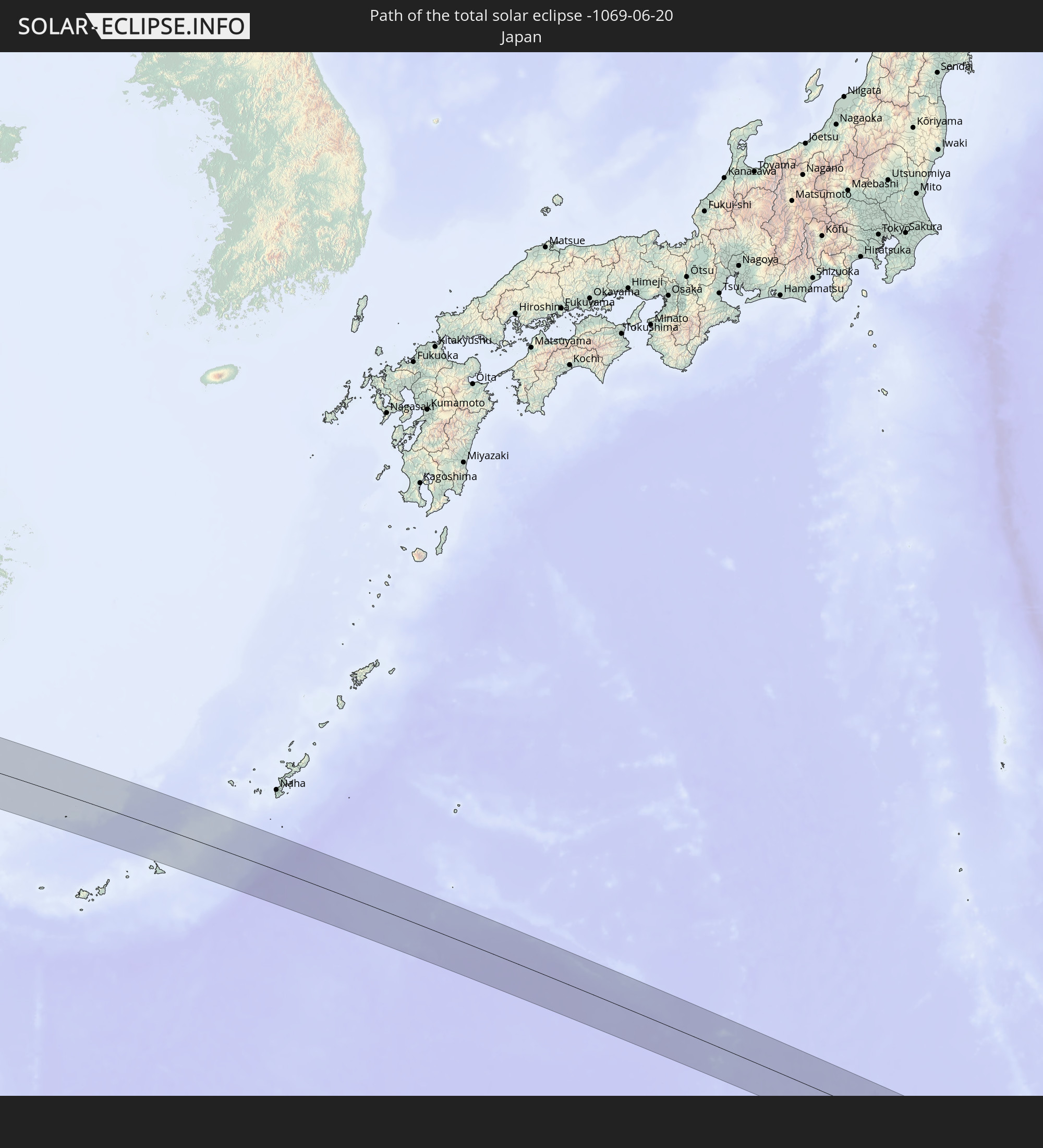 Japan
Japan
 Northern Mariana Islands
In den folgenden Ländern ist die Sonnenfinsternis partiell zu sehen
 Russia
 Algeria
 Niger
Niger
 Nigeria
 Cameroon
 Libya
Libya
 Republic of the Congo
 Democratic Republic of the Congo
 Chad
Chad
 Central African Republic
 South Africa
 Greece
 Sudan
Sudan
 Zambia
 Egypt
Egypt
 Zimbabwe
 Turkey
 Rwanda
 Burundi
 Tanzania
 Uganda
 Mozambique
 Cyprus
 Malawi
 Ethiopia
 Kenya
Kenya
 State of Palestine
 Israel
 Saudi Arabia
 Jordan
 Lebanon
 Syria
Syria
 Eritrea
 Iraq
Iraq
 Georgia
 French Southern and Antarctic Lands
 Somalia
 Djibouti
 Yemen
Yemen
 Madagascar
 Comoros
 Armenia
 Iran
Iran
 Azerbaijan
 Mayotte
 Seychelles
 Kazakhstan
 Kuwait
 Bahrain
 Qatar
Qatar
 United Arab Emirates
 Oman
Oman
 Turkmenistan
 Réunion
 Uzbekistan
 Mauritius
 Afghanistan
 Pakistan
 Tajikistan
 India
India
 Kyrgyzstan
 British Indian Ocean Territory
 Maldives
 China
China
 Sri Lanka
 Nepal
Nepal
 Mongolia
 Bangladesh
 Bhutan
 Myanmar
 Indonesia
 Thailand
 Malaysia
 Laos
Laos
 Vietnam
 Cambodia
 Singapore
 Australia
 Macau
Macau
 Hong Kong
 Brunei
 Taiwan
 Philippines
 Japan
Japan
 East Timor
 North Korea
 South Korea
 Palau
Palau
 Federated States of Micronesia
 Papua New Guinea
 Guam
Guam
 Northern Mariana Islands
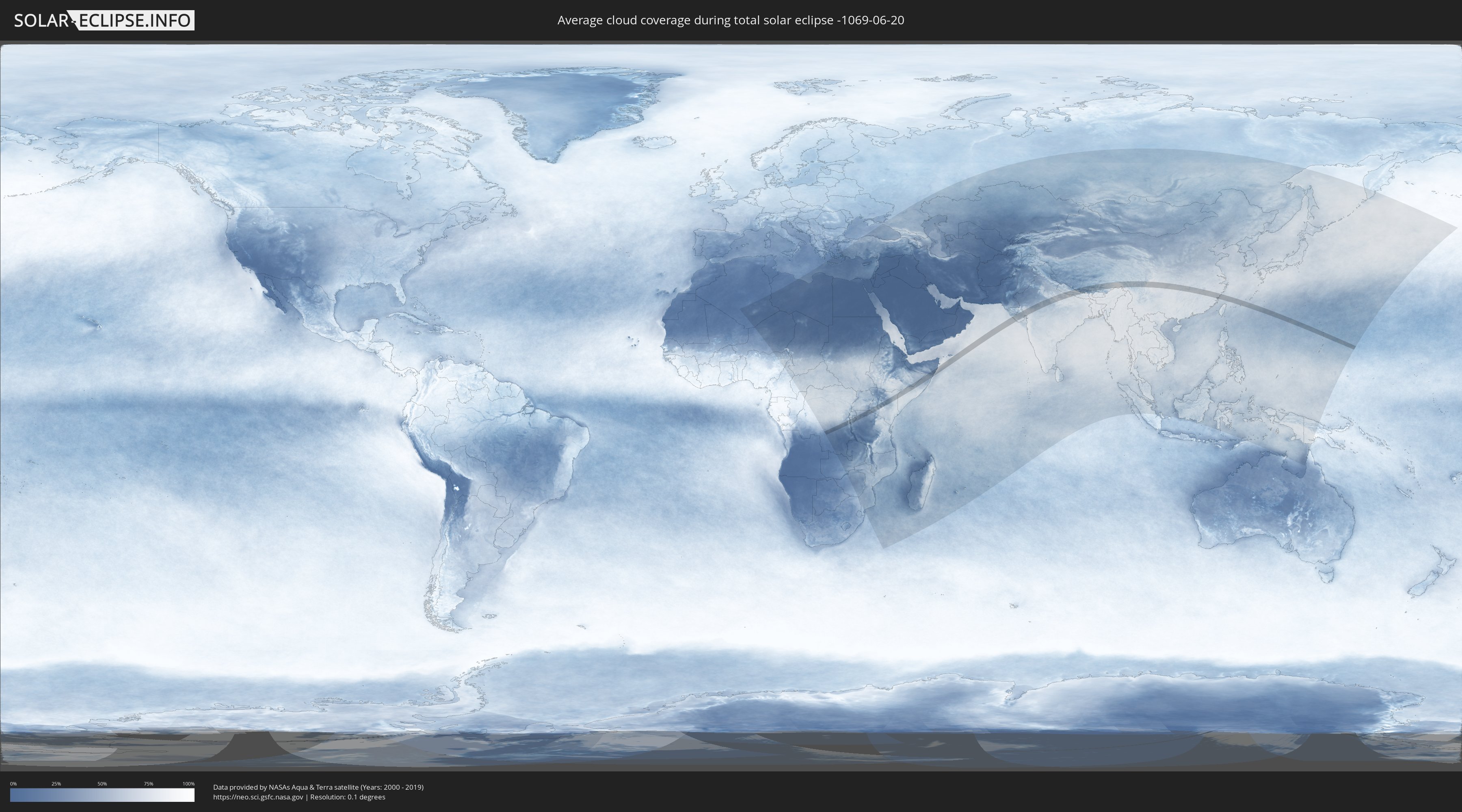
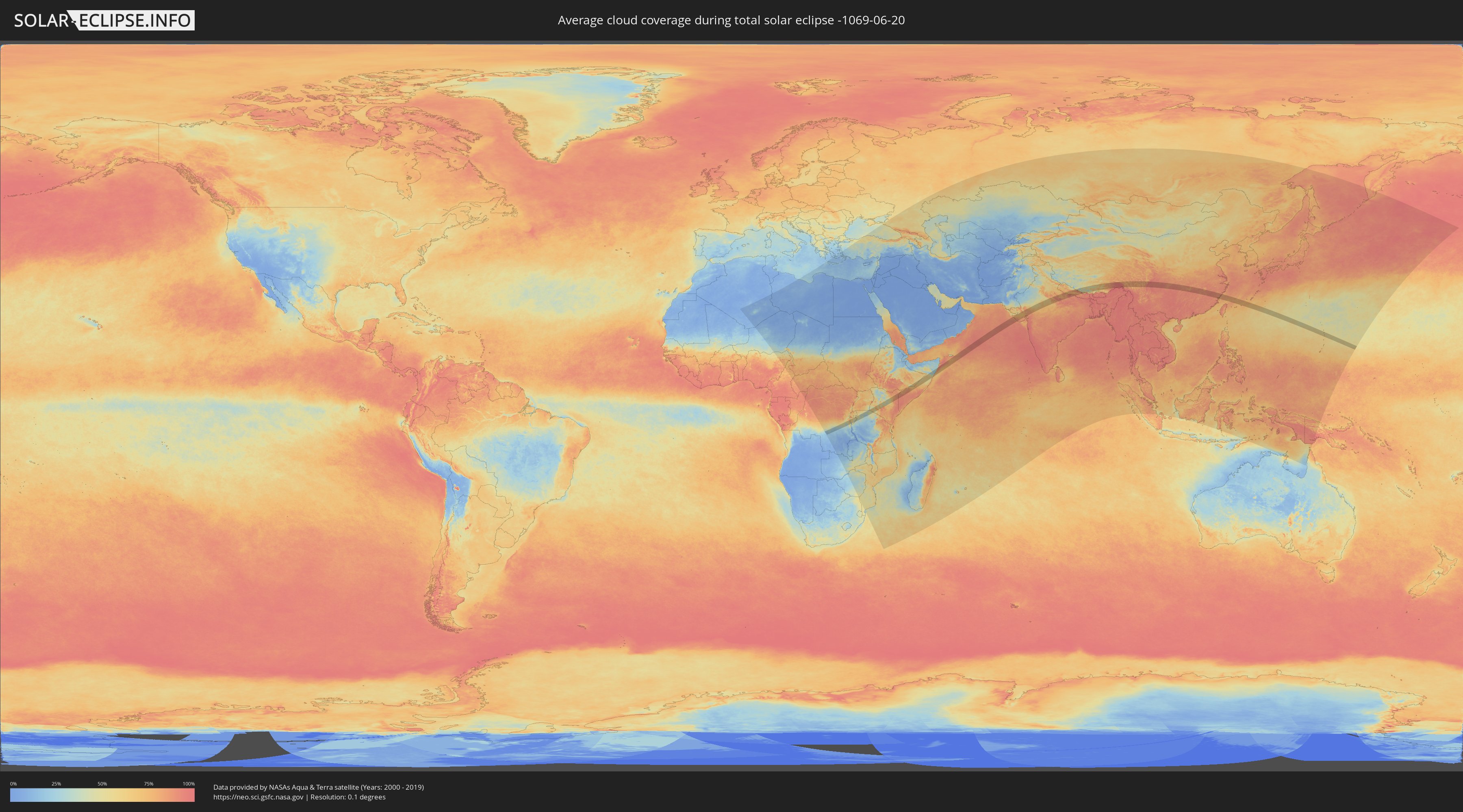
How will be the weather during the total solar eclipse on 06/20/-1069?
Where is the best place to see the total solar eclipse of 06/20/-1069?
The following maps show the average cloud coverage for the day of the total solar eclipse.
With the help of these maps, it is possible to find the place along the eclipse path, which has the best
chance of a cloudless sky.
Nevertheless, you should consider local circumstances and inform about the weather of your chosen
observation site.
The data is provided by NASAs satellites
AQUA and TERRA.
The cloud maps are averaged over a period of 19 years (2000 - 2019).
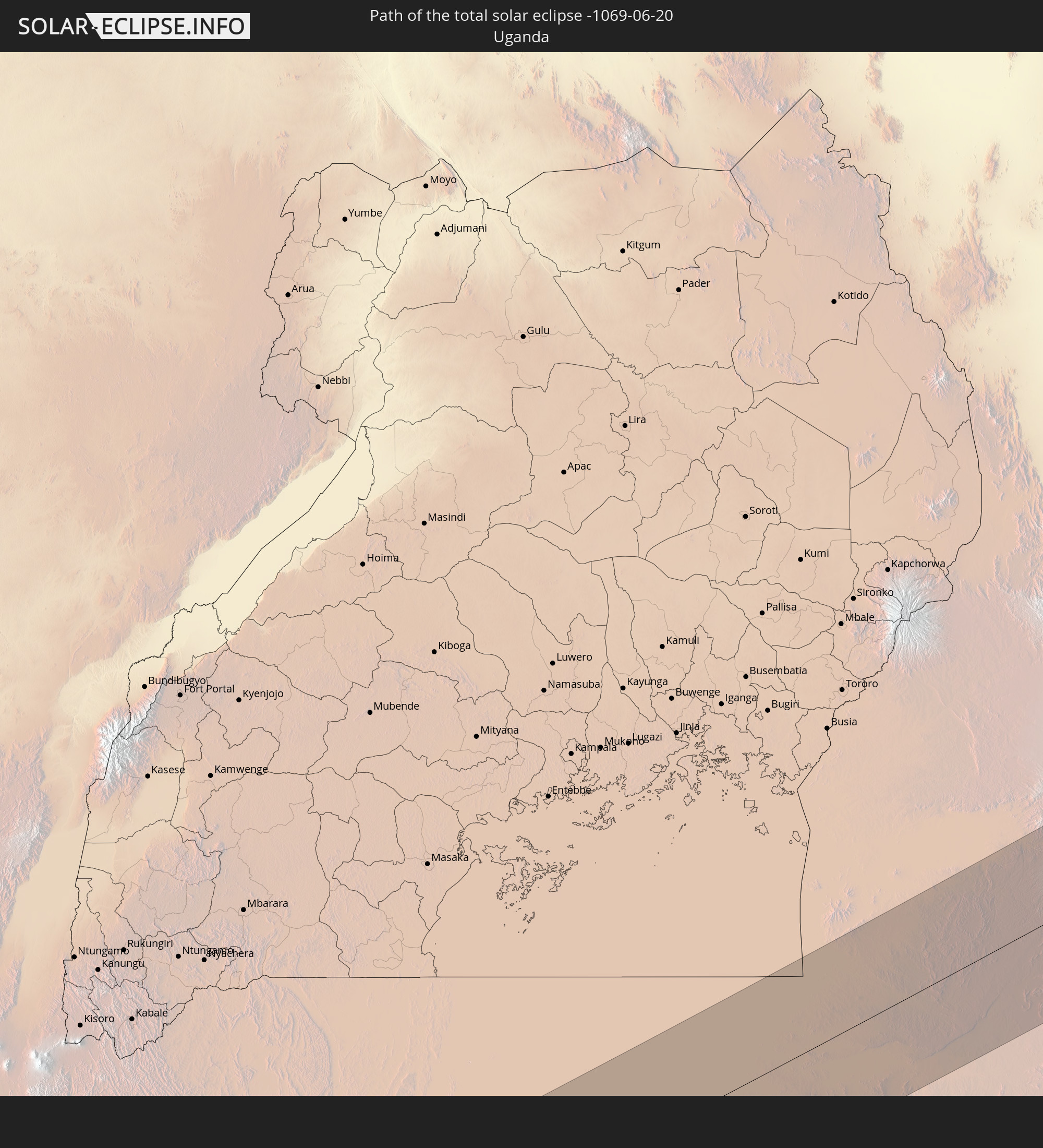
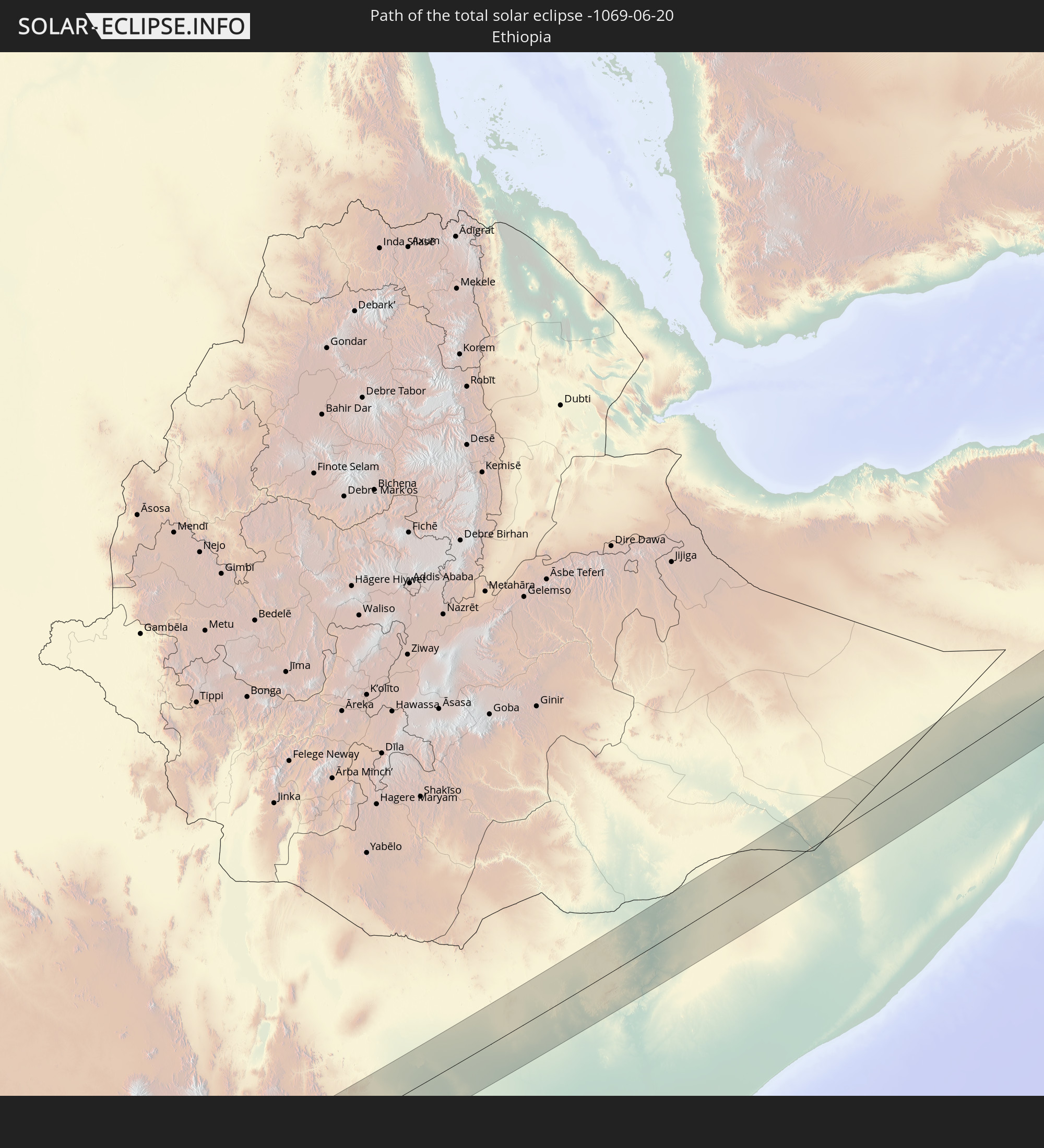
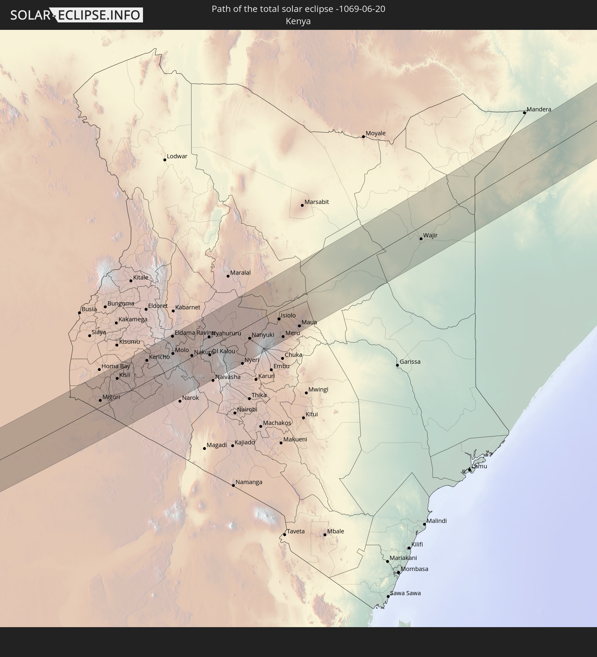
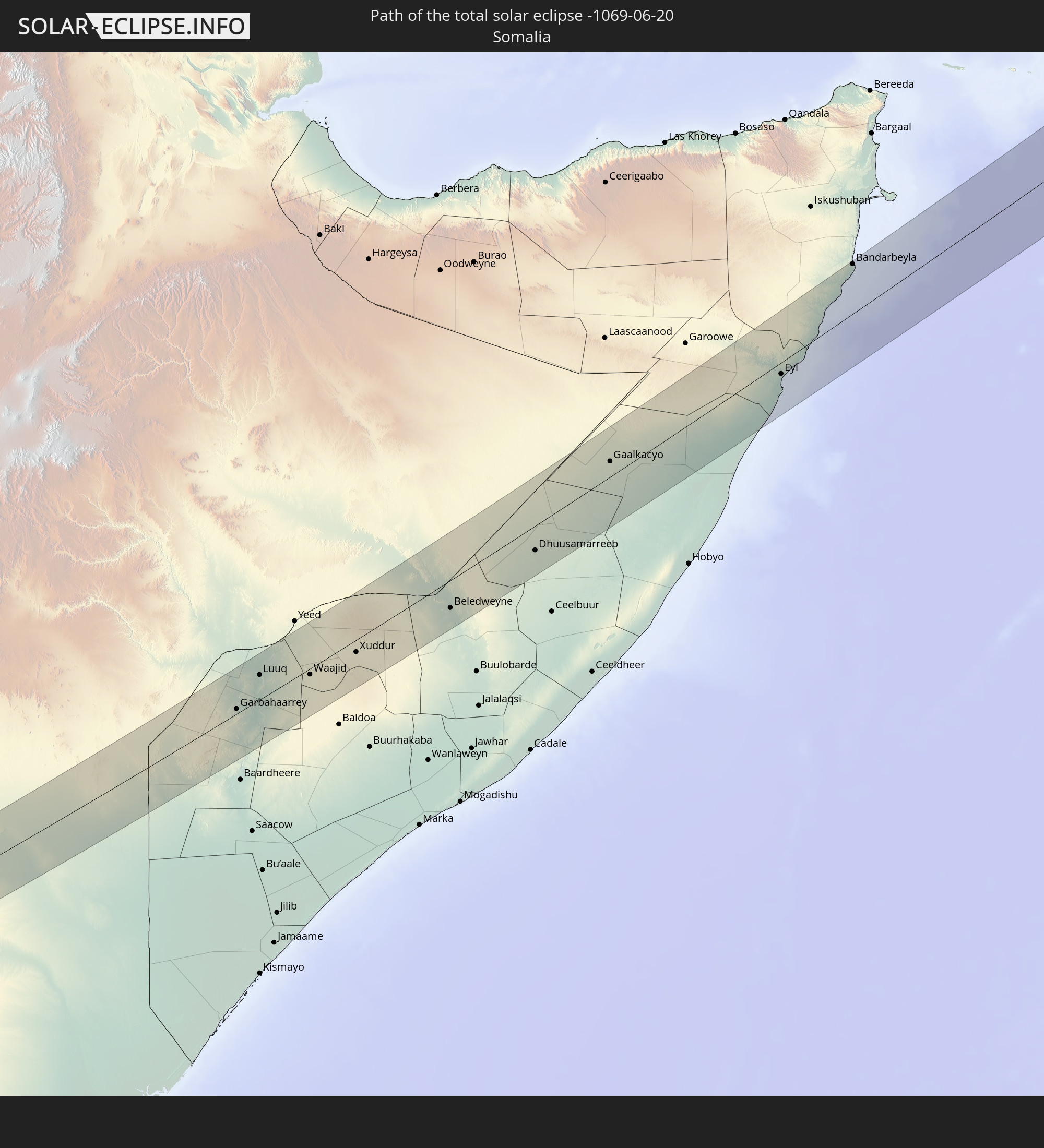
Detailed country maps
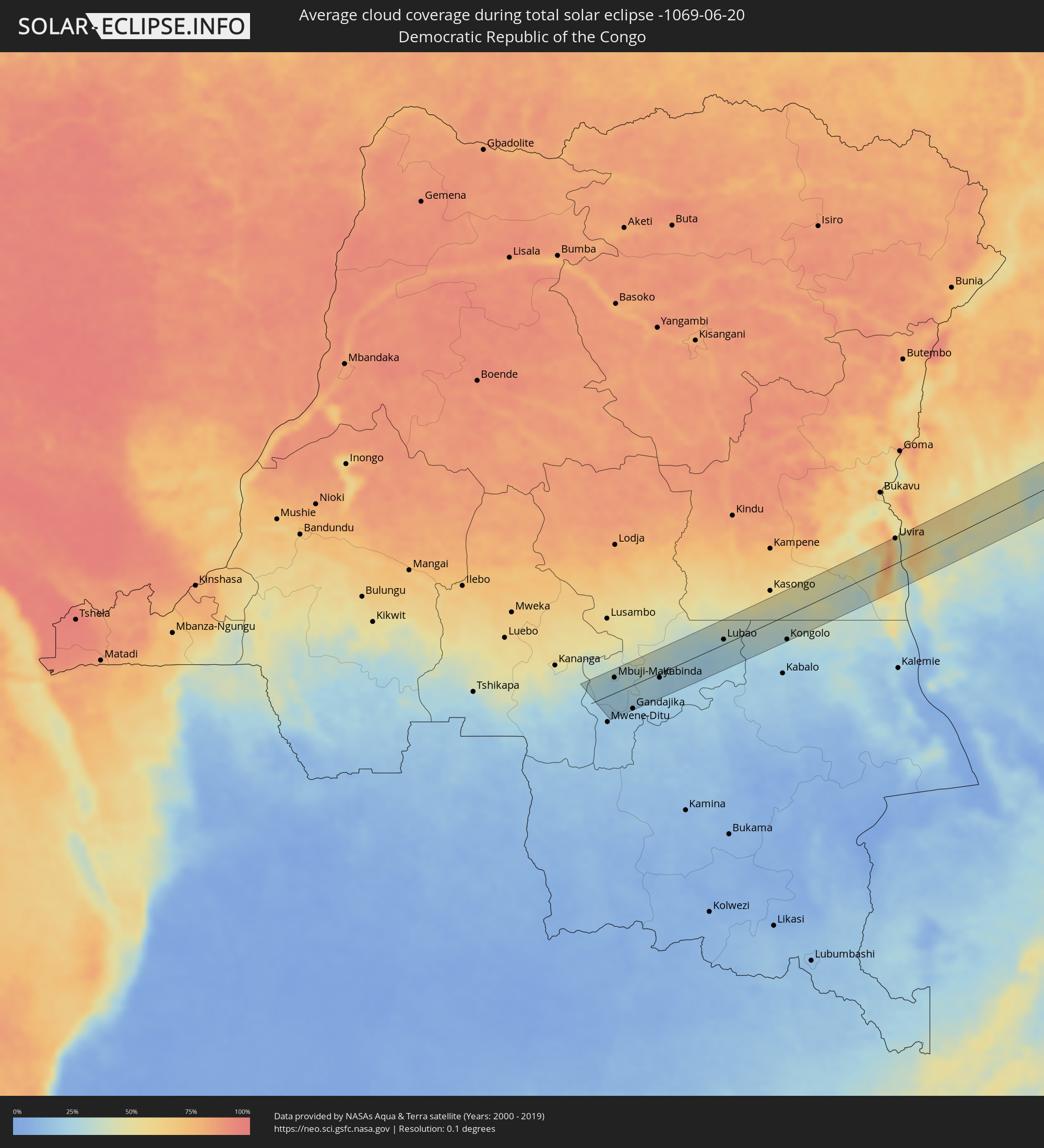 Democratic Republic of the Congo
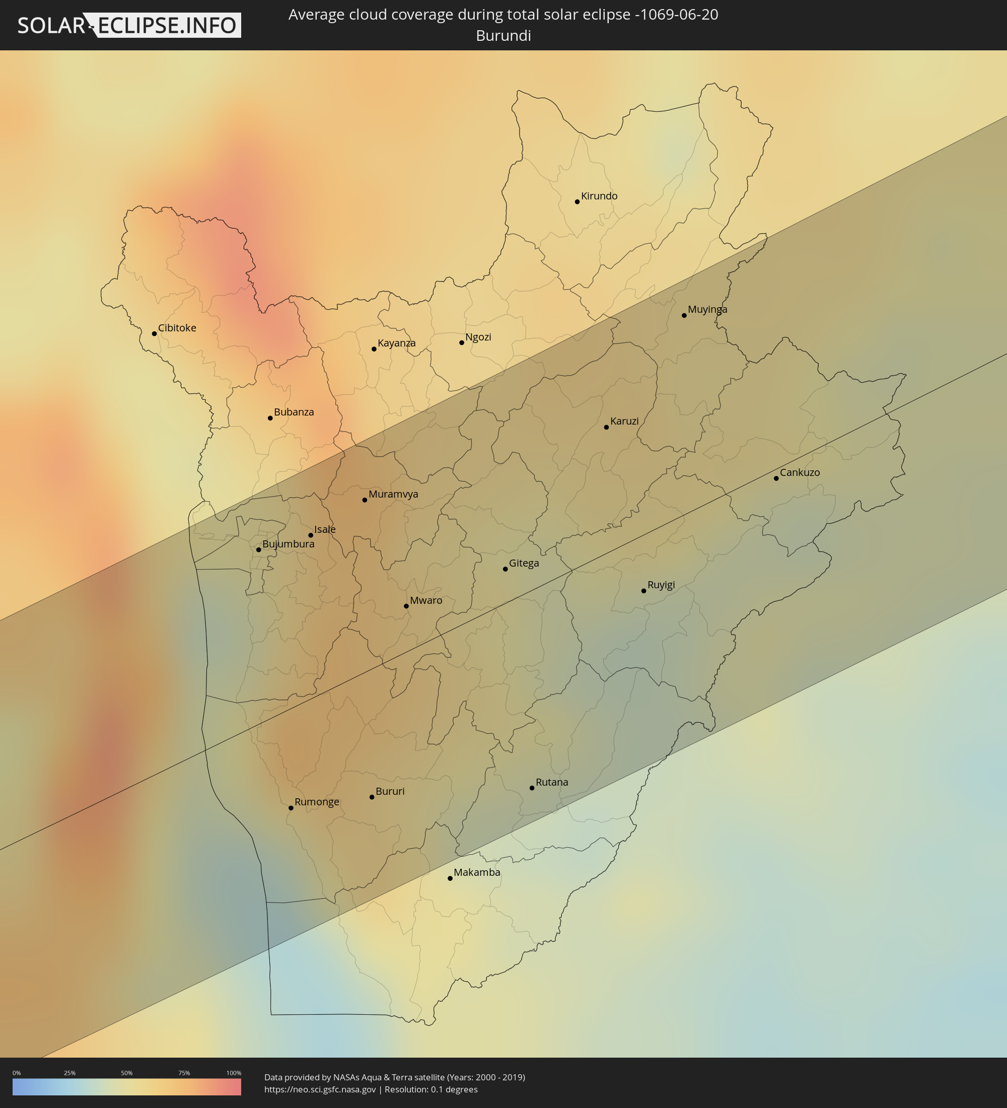 Burundi
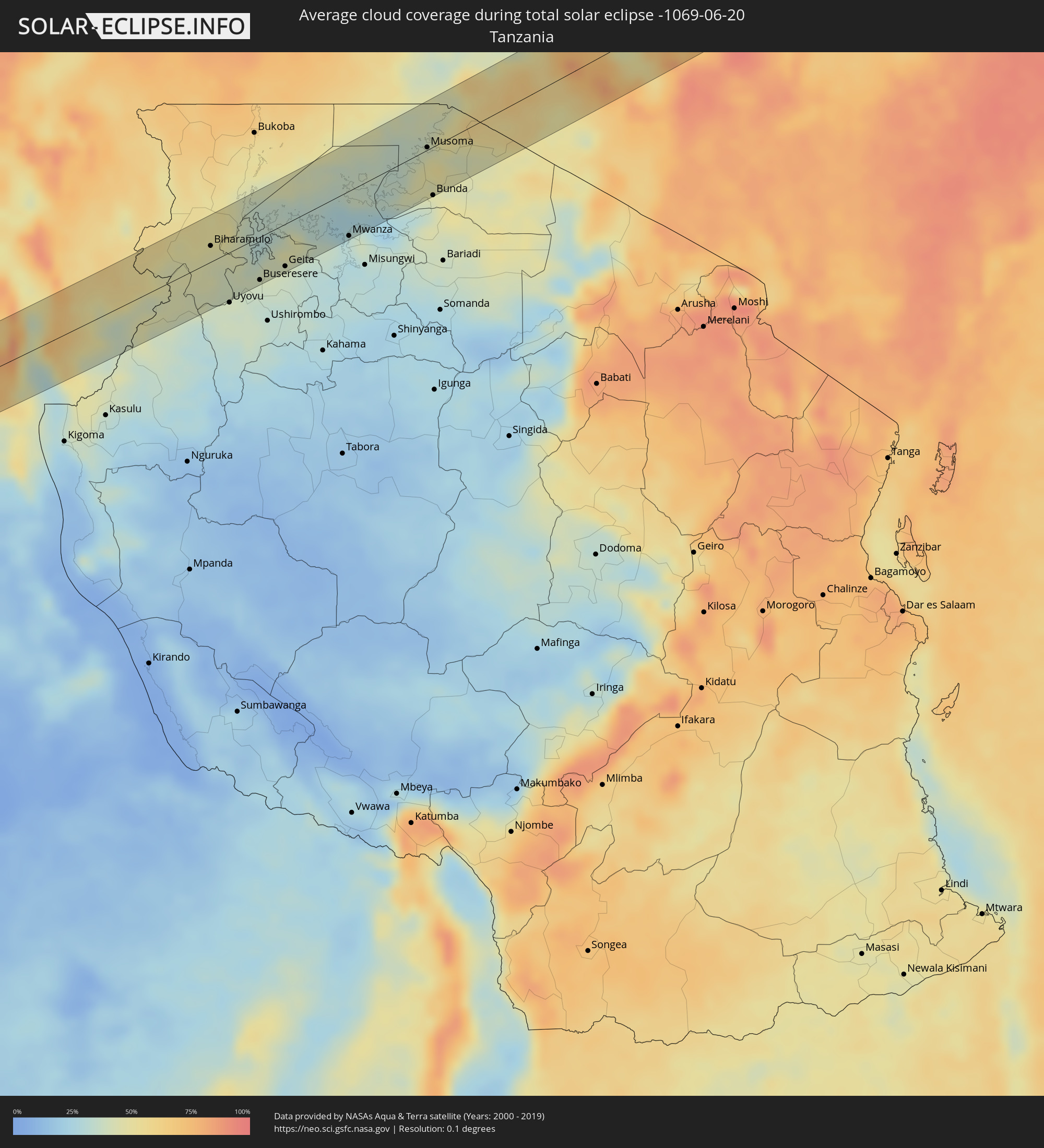 Tanzania
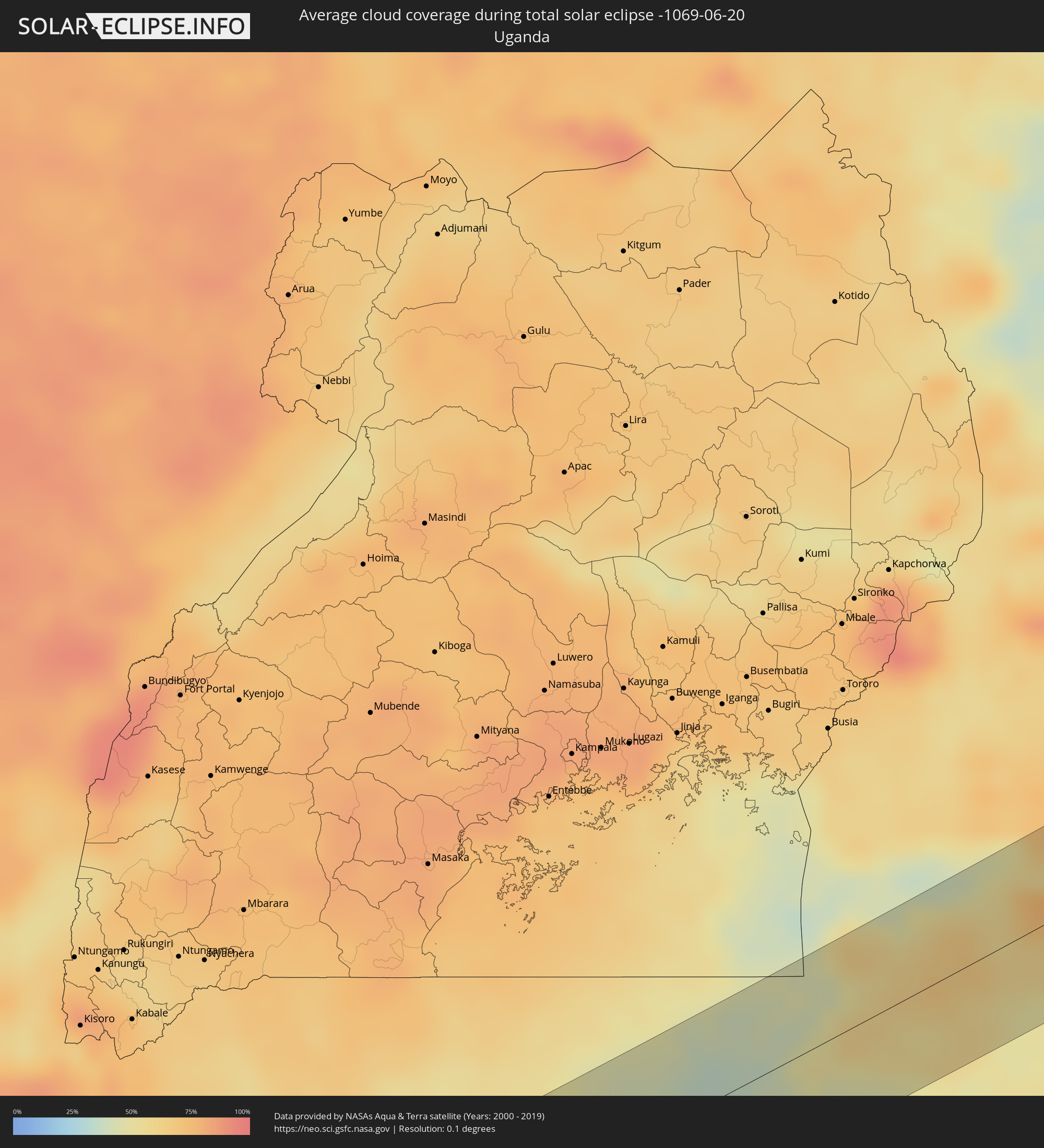 Uganda
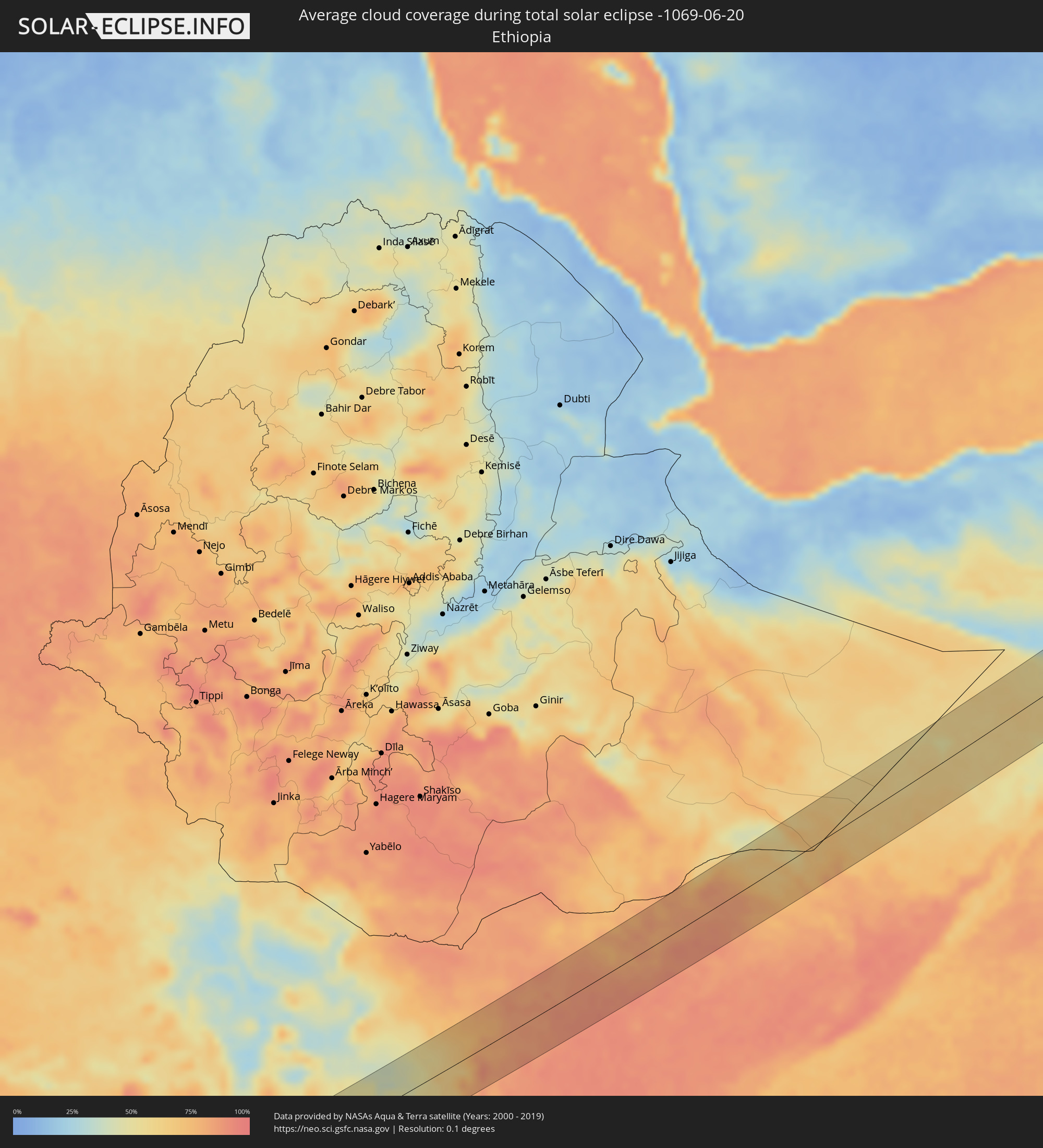 Ethiopia
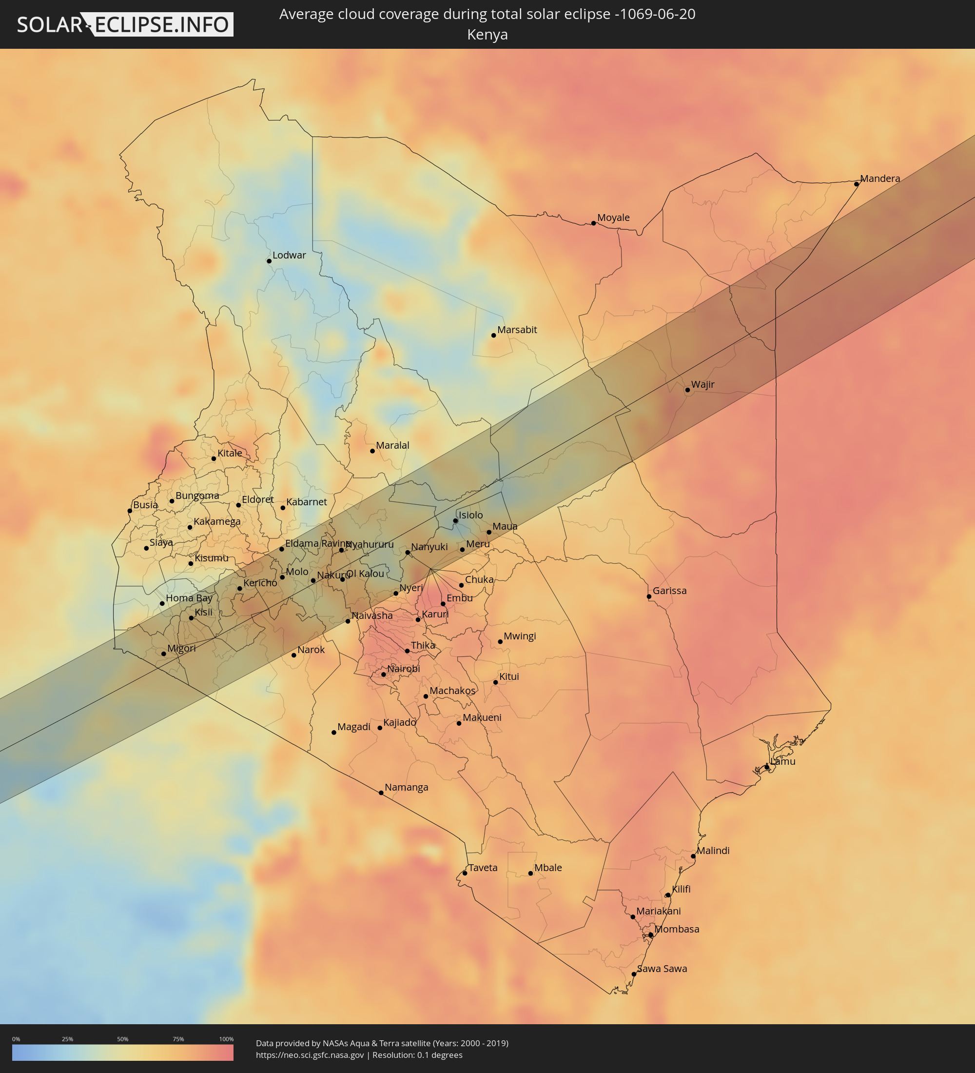 Kenya
Kenya
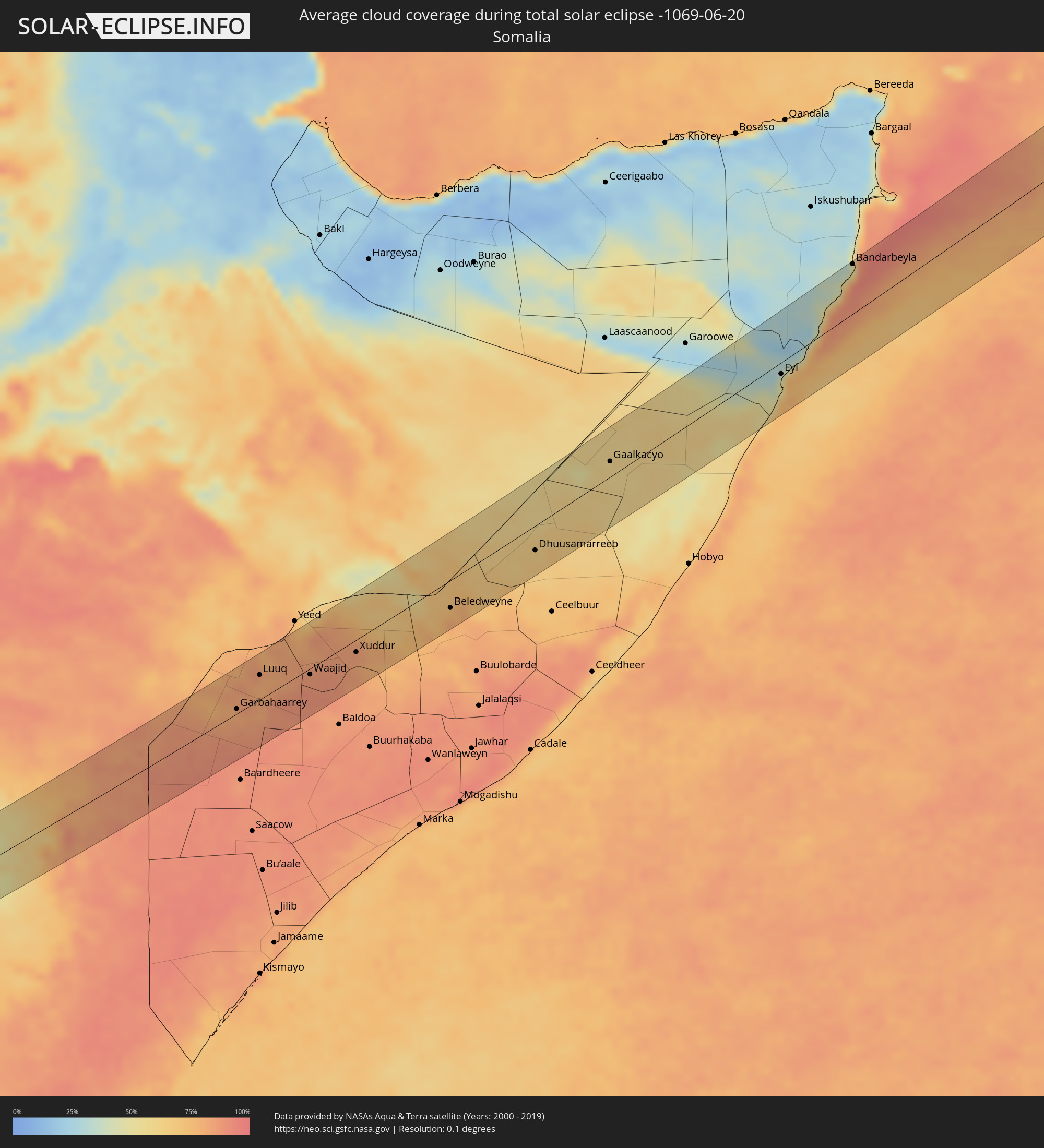 Somalia
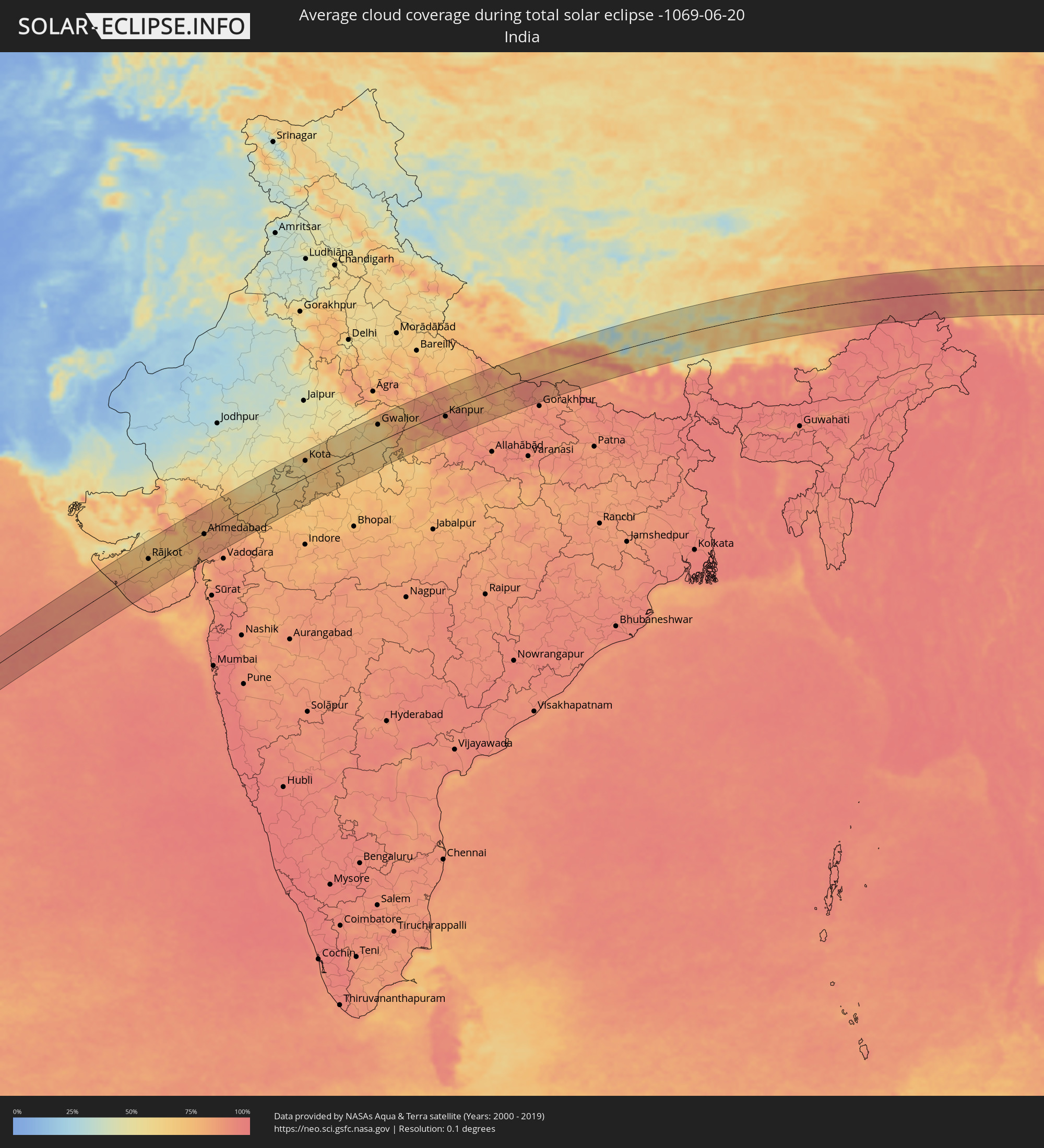 India
India
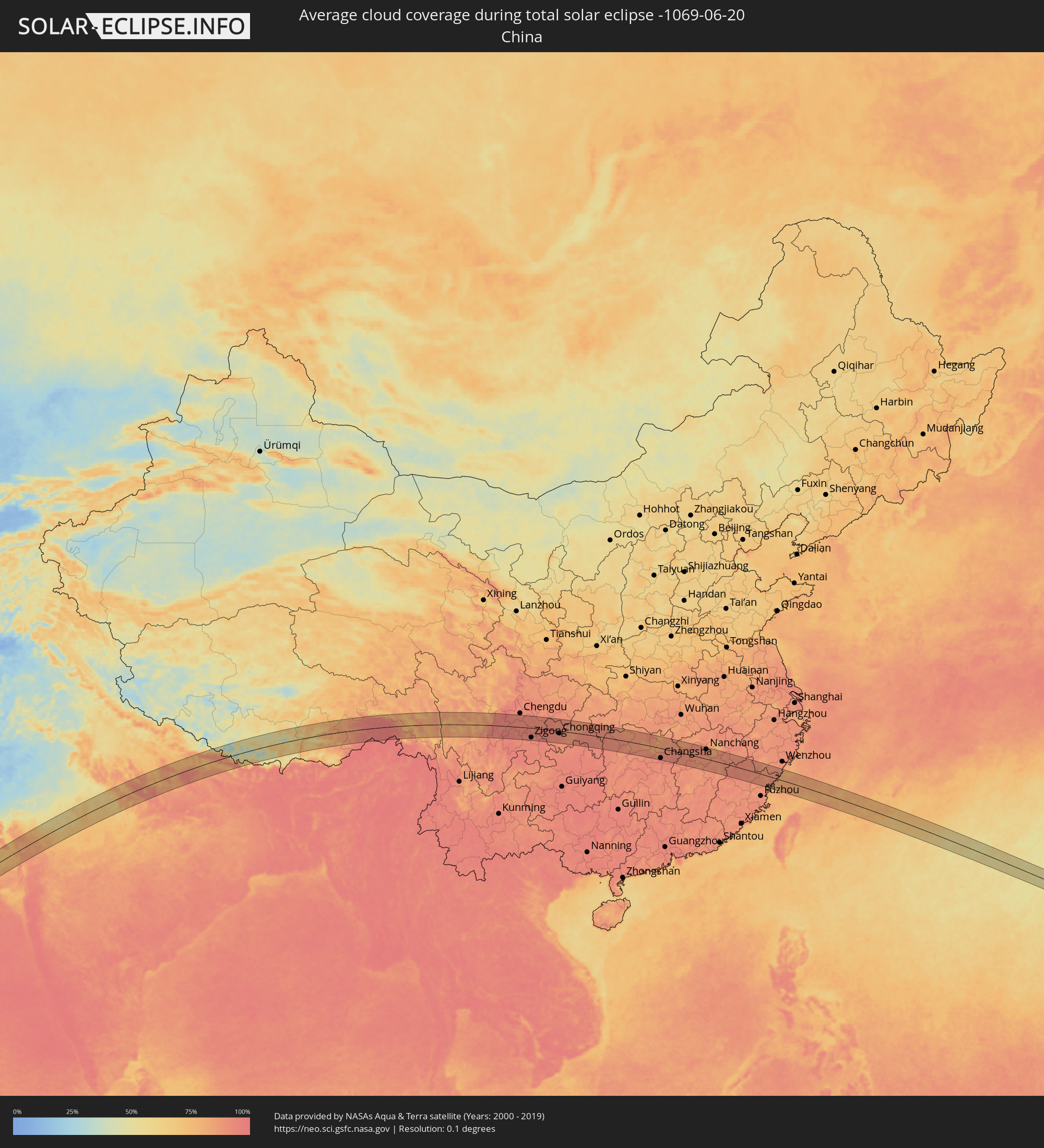 China
China
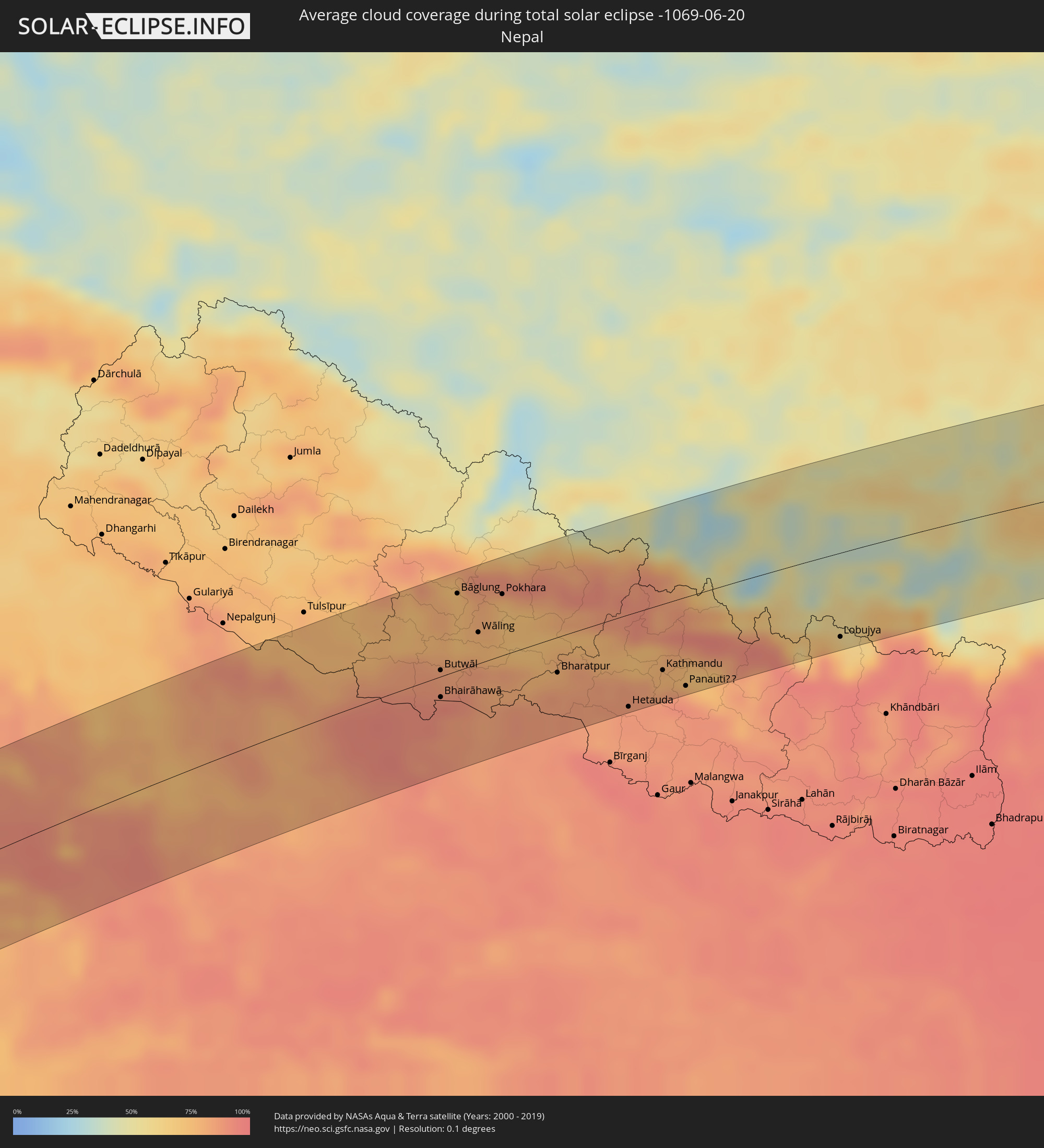 Nepal
Nepal
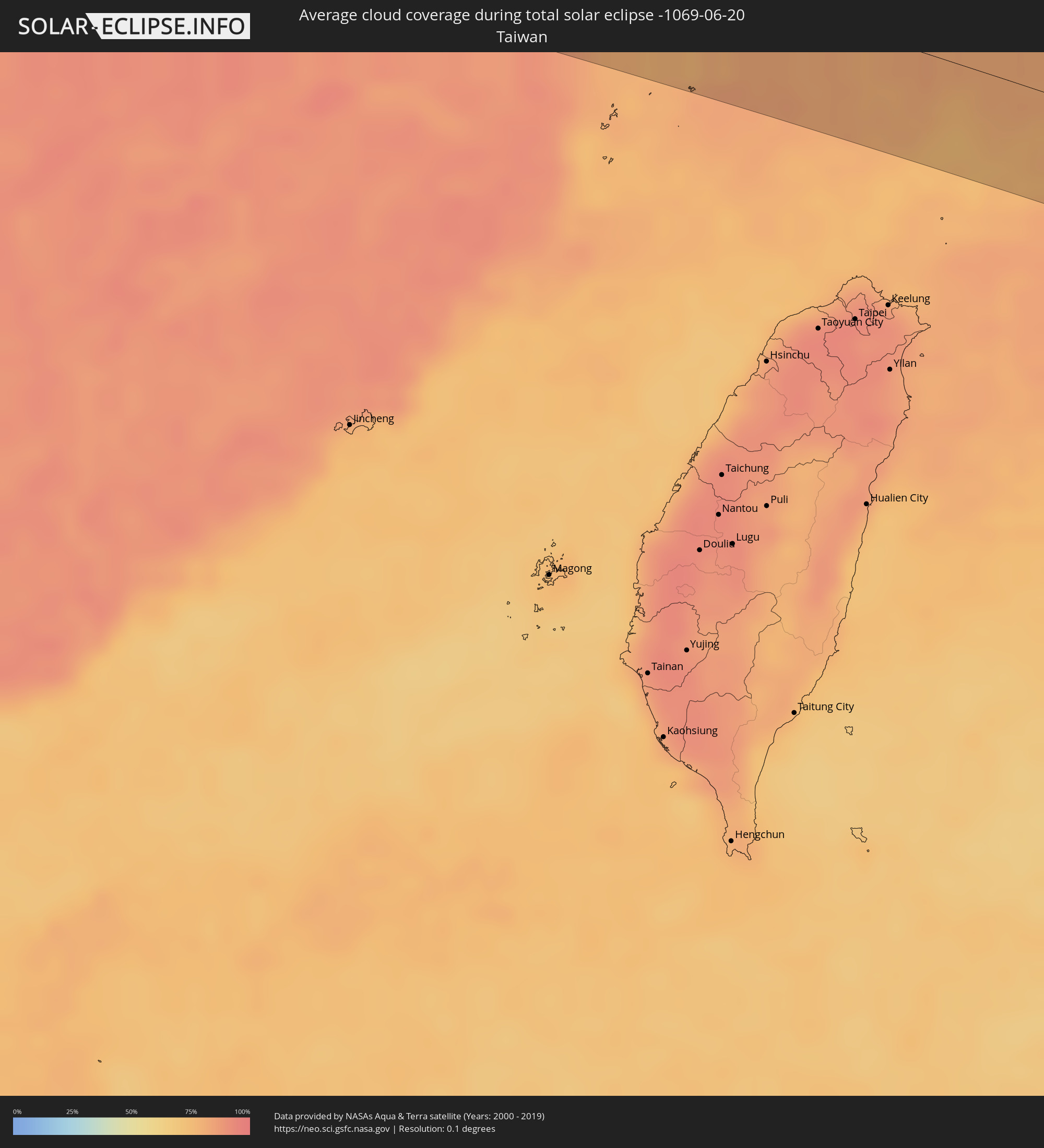 Taiwan
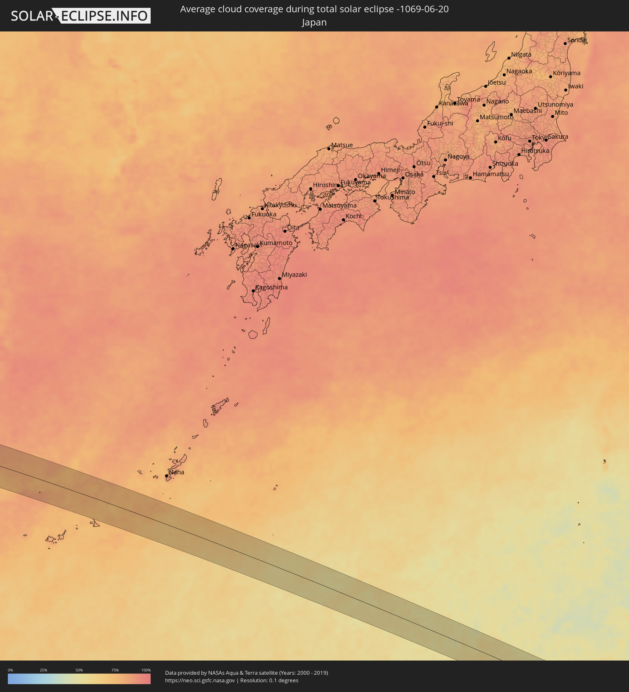 Japan
Japan
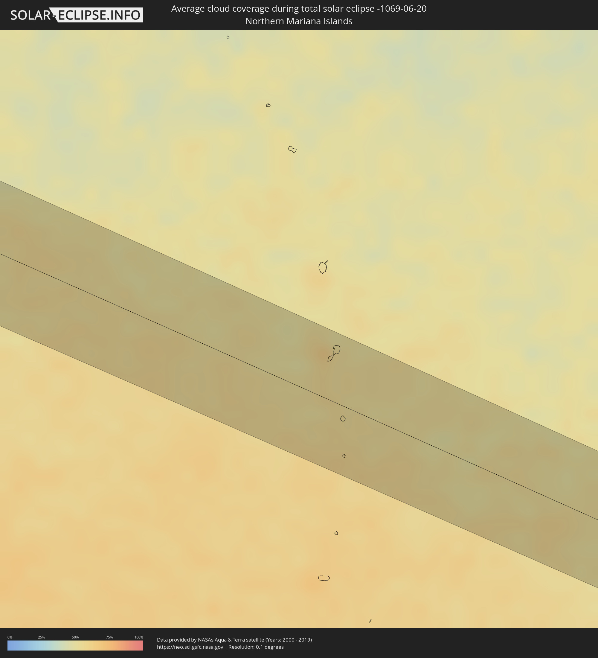 Northern Mariana Islands
Cities inside the path of the eclipse
The following table shows all locations with a population of more than 5,000 inside the eclipse path. Cities which have more than 100,000 inhabitants are marked bold. A click at the locations opens a detailed map.
| City | Type | Eclipse duration | Local time of max. eclipse | Distance to central line | Ø Cloud coverage |
|
Mbuji-Mayi, Kasaï-Oriental
|
total | - | 06:41:54 UTC+02:10 | 31 km | 22% |
|
Gandajika, Kasaï-Oriental
|
total | - | 06:41:36 UTC+02:10 | 47 km | 18% |
|
Kabinda, Kasaï-Oriental
|
total | - | 06:41:46 UTC+02:10 | 9 km | 22% |
|
Lubao, Kasaï-Oriental
|
total | - | 06:41:57 UTC+02:10 | 9 km | 26% |
|
Kongolo, Katanga
|
total | - | 06:41:50 UTC+02:10 | 49 km | 25% |
|
Uvira, South Kivu
|
total | - | 06:42:47 UTC+02:10 | 49 km | 64% |
|
Bujumbura, Bujumbura Mairie
|
total | - | 06:42:48 UTC+02:10 | 40 km | 57% |
|
Rumonge, Rumonge
|
total | - | 06:42:28 UTC+02:10 | 23 km | 33% |
|
Isale, Bujumbura Rural
|
total | - | 06:42:49 UTC+02:10 | 37 km | 66% |
|
Muramvya, Muramvya
|
total | - | 06:42:51 UTC+02:10 | 39 km | 66% |
|
Bururi, Bururi
|
total | - | 06:42:29 UTC+02:10 | 30 km | 59% |
|
Mwaro, Mwaro
|
total | - | 06:42:43 UTC+02:10 | 10 km | 63% |
|
Gitega, Gitega
|
total | - | 06:42:46 UTC+02:10 | 8 km | 49% |
|
Rutana, Rutana
|
total | - | 06:42:30 UTC+02:10 | 46 km | 38% |
|
Karuzi, Karuzi
|
total | - | 06:42:58 UTC+02:10 | 29 km | 54% |
|
Ruyigi, Ruyigi
|
total | - | 06:42:45 UTC+02:10 | 13 km | 37% |
|
Muyinga, Muyinga
|
total | - | 06:43:07 UTC+02:10 | 45 km | 54% |
|
Mabamba, Kigoma
|
total | - | 06:59:37 UTC+02:27 | 38 km | 44% |
|
Bugarama, Kagera
|
total | - | 07:00:03 UTC+02:27 | 34 km | 53% |
|
Cankuzo, Cankuzo
|
total | - | 06:42:54 UTC+02:10 | 2 km | 40% |
|
Rulenge, Kagera
|
total | - | 07:00:08 UTC+02:27 | 44 km | 52% |
|
Kibondo, Kigoma
|
total | - | 06:59:38 UTC+02:27 | 47 km | 37% |
|
Kakonko, Kigoma
|
total | - | 06:59:49 UTC+02:27 | 29 km | 41% |
|
Biharamulo, Kagera
|
total | - | 07:00:13 UTC+02:27 | 18 km | 46% |
|
Chato, Geita
|
total | - | 07:00:15 UTC+02:27 | 5 km | 31% |
|
Buseresere, Geita
|
total | - | 07:00:02 UTC+02:27 | 49 km | 37% |
|
Katoro, Geita
|
total | - | 07:00:02 UTC+02:27 | 50 km | 37% |
|
Geita, Geita
|
total | - | 07:00:09 UTC+02:27 | 48 km | 36% |
|
Mwanza, Mwanza
|
total | - | 07:00:26 UTC+02:27 | 51 km | 33% |
|
Muriti, Mara
|
total | - | 07:00:46 UTC+02:27 | 1 km | 37% |
|
Nansio, Mara
|
total | - | 07:00:41 UTC+02:27 | 21 km | 30% |
|
Nakatunguru, Mara
|
total | - | 07:00:42 UTC+02:27 | 20 km | 30% |
|
Kibara, Mara
|
total | - | 07:00:44 UTC+02:27 | 43 km | 28% |
|
Mugango, Mara
|
total | - | 07:01:04 UTC+02:27 | 10 km | 47% |
|
Musoma, Mara
|
total | - | 07:01:12 UTC+02:27 | 3 km | 46% |
|
Bunda, Mara
|
total | - | 07:00:51 UTC+02:27 | 55 km | 45% |
|
Butiama, Mara
|
total | - | 07:01:03 UTC+02:27 | 32 km | 46% |
|
Nyamuswa, Mara
|
total | - | 07:00:58 UTC+02:27 | 48 km | 42% |
|
Tarime, Mara
|
total | - | 07:01:23 UTC+02:27 | 12 km | 47% |
|
Migori, Migori
|
total | - | 07:01:36 UTC+02:27 | 11 km | 56% |
|
Sirari, Mara
|
total | - | 07:01:28 UTC+02:27 | 8 km | 54% |
|
Kihancha, Migori
|
total | - | 07:01:32 UTC+02:27 | 9 km | 55% |
|
Oyugis, Homa Bay
|
total | - | 07:02:02 UTC+02:27 | 51 km | 58% |
|
Kisii, Kisii
|
total | - | 07:01:55 UTC+02:27 | 33 km | 65% |
|
Nyamira, Nyamira
|
total | - | 07:01:58 UTC+02:27 | 25 km | 60% |
|
Kericho, Kericho
|
total | - | 07:02:14 UTC+02:27 | 36 km | 75% |
|
Bomet, Bomet
|
total | - | 07:01:57 UTC+02:27 | 8 km | 57% |
|
Eldama Ravine, Baringo
|
total | - | 07:02:38 UTC+02:27 | 53 km | 64% |
|
Molo, Nakuru
|
total | - | 07:02:25 UTC+02:27 | 23 km | 68% |
|
Rongai, Nakuru
|
total | - | 07:02:30 UTC+02:27 | 24 km | 51% |
|
Nakuru, Nakuru
|
total | - | 07:02:28 UTC+02:27 | 2 km | 49% |
|
Nyahururu, Laikipia
|
total | - | 07:02:46 UTC+02:27 | 18 km | 61% |
|
Ol Kalou, Nyandarua
|
total | - | 07:02:32 UTC+02:27 | 13 km | 67% |
|
Naro Moru, Laikipia
|
total | - | 07:02:46 UTC+02:27 | 38 km | 61% |
|
Nanyuki, Laikipia
|
total | - | 07:02:55 UTC+02:27 | 23 km | 64% |
|
Isiolo, Isiolo
|
total | - | 07:03:19 UTC+02:27 | 18 km | 34% |
|
Meru, Meru
|
total | - | 07:03:06 UTC+02:27 | 52 km | 73% |
|
Maua, Isiolo
|
total | - | 07:03:20 UTC+02:27 | 49 km | 77% |
|
Wajir, Wajir
|
total | - | 07:05:15 UTC+02:27 | 21 km | 82% |
|
Garbahaarrey, Gedo
|
total | - | 07:07:34 UTC+02:27 | 6 km | 79% |
|
Luuq, Gedo
|
total | - | 07:08:10 UTC+02:27 | 33 km | 84% |
|
Waajid, Bakool
|
total | - | 07:08:31 UTC+02:27 | 8 km | 86% |
|
Xuddur, Bakool
|
total | - | 07:09:10 UTC+02:27 | 16 km | 84% |
|
Beledweyne, Hiiraan
|
total | - | 07:10:31 UTC+02:27 | 36 km | 76% |
|
Dhuusamarreeb, Galguduud
|
total | - | 07:12:05 UTC+02:27 | 32 km | 64% |
|
Gaalkacyo, Mudug
|
total | - | 07:14:08 UTC+02:27 | 20 km | 57% |
|
Eyl, Nugaal
|
total | - | 07:17:23 UTC+02:27 | 15 km | 42% |
|
Bandarbeyla, Bari
|
total | - | 07:20:04 UTC+02:27 | 63 km | 47% |
|
Porbandar, Gujarat
|
total | - | 10:59:23 UTC+05:21 | 24 km | 80% |
|
Jūnāgadh, Gujarat
|
total | - | 11:00:57 UTC+05:21 | 34 km | 87% |
|
Jetpur, Gujarat
|
total | - | 11:01:40 UTC+05:21 | 21 km | 81% |
|
Rājkot, Gujarat
|
total | - | 11:02:51 UTC+05:21 | 21 km | 73% |
|
Surendranagar, Gujarat
|
total | - | 11:05:21 UTC+05:21 | 17 km | 70% |
|
Ahmedabad, Gujarat
|
total | - | 11:07:51 UTC+05:21 | 3 km | 78% |
|
Ghandinagar, Gujarat
|
total | - | 11:08:21 UTC+05:21 | 10 km | 81% |
|
Nadiād, Gujarat
|
total | - | 11:07:58 UTC+05:21 | 49 km | 83% |
|
Ānand, Gujarat
|
total | - | 11:07:58 UTC+05:21 | 68 km | 85% |
|
Mandsaur, Madhya Pradesh
|
total | - | 11:15:03 UTC+05:21 | 25 km | 65% |
|
Kota, Rajasthan
|
total | - | 11:18:26 UTC+05:21 | 49 km | 59% |
|
Guna, Madhya Pradesh
|
total | - | 11:21:14 UTC+05:21 | 71 km | 70% |
|
Shivpuri, Madhya Pradesh
|
total | - | 11:23:08 UTC+05:21 | 9 km | 67% |
|
Gwalior, Madhya Pradesh
|
total | - | 11:25:26 UTC+05:21 | 50 km | 59% |
|
Jhānsi, Uttar Pradesh
|
total | - | 11:25:26 UTC+05:21 | 45 km | 65% |
|
Bhind, Madhya Pradesh
|
total | - | 11:27:21 UTC+05:21 | 59 km | 71% |
|
Etāwah, Uttar Pradesh
|
total | - | 11:28:12 UTC+05:21 | 71 km | 73% |
|
Orai, Uttar Pradesh
|
total | - | 11:28:18 UTC+05:21 | 27 km | 81% |
|
Kanpur, Uttar Pradesh
|
total | - | 11:31:07 UTC+05:21 | 13 km | 76% |
|
Unnāo, Uttar Pradesh
|
total | - | 11:31:34 UTC+05:21 | 10 km | 89% |
|
Lucknow, Uttar Pradesh
|
total | - | 11:33:01 UTC+05:21 | 3 km | 79% |
|
Raebareli, Uttar Pradesh
|
total | - | 11:33:06 UTC+05:21 | 71 km | 87% |
|
Bahraigh, Uttar Pradesh
|
total | - | 11:35:32 UTC+05:21 | 55 km | 83% |
|
Gondā City, Uttar Pradesh
|
total | - | 11:35:58 UTC+05:21 | 4 km | 83% |
|
Fyzābād, Uttar Pradesh
|
total | - | 11:36:05 UTC+05:21 | 48 km | 78% |
|
Butwāl, Western Region
|
total | - | 12:00:30 UTC+05:41 | 5 km | 87% |
|
Bhairāhawā, Western Region
|
total | - | 12:00:18 UTC+05:41 | 16 km | 92% |
|
Tānsen, Western Region
|
total | - | 12:00:55 UTC+05:41 | 19 km | 81% |
|
Bāglung, Western Region
|
total | - | 12:01:25 UTC+05:41 | 61 km | 74% |
|
Wāling, Western Region
|
total | - | 12:01:35 UTC+05:41 | 25 km | 76% |
|
Bhattarai Danda, Western Region
|
total | - | 12:01:55 UTC+05:41 | 9 km | 76% |
|
Pokhara, Western Region
|
total | - | 12:02:23 UTC+05:41 | 48 km | 76% |
|
Bharatpur, Central Region
|
total | - | 12:03:02 UTC+05:41 | 28 km | 80% |
|
Hetauda, Central Region
|
total | - | 12:04:22 UTC+05:41 | 73 km | 88% |
|
Kirtipur, Central Region
|
total | - | 12:05:14 UTC+05:41 | 54 km | 78% |
|
Pātan, Central Region
|
total | - | 12:05:20 UTC+05:41 | 55 km | 78% |
|
Kathmandu, Central Region
|
total | - | 12:05:22 UTC+05:41 | 52 km | 78% |
|
Hari Bdr Tamang House, Central Region
|
total | - | 12:05:40 UTC+05:41 | 64 km | 85% |
|
kankrabari Dovan, Central Region
|
total | - | 12:05:40 UTC+05:41 | 64 km | 85% |
|
Panauti̇̄, Central Region
|
total | - | 12:05:46 UTC+05:41 | 70 km | 85% |
|
Banepā, Central Region
|
total | - | 12:05:50 UTC+05:41 | 66 km | 85% |
|
Lobujya, Eastern Region
|
total | - | 12:09:31 UTC+05:41 | 67 km | 70% |
|
Rikaze, Tibet Autonomous Region
|
total | - | 14:34:33 UTC+08:00 | 25 km | 40% |
|
Lhasa, Tibet Autonomous Region
|
total | - | 14:40:26 UTC+08:00 | 26 km | 56% |
|
Kangding, Sichuan
|
total | - | 15:06:38 UTC+08:00 | 3 km | 87% |
|
Leshan, Sichuan
|
total | - | 15:10:40 UTC+08:00 | 41 km | 92% |
|
Yanjiang, Sichuan
|
total | - | 15:12:21 UTC+08:00 | 28 km | 92% |
|
Zigong, Sichuan
|
total | - | 15:12:53 UTC+08:00 | 57 km | 91% |
|
Neijiang, Sichuan
|
total | - | 15:13:24 UTC+08:00 | 28 km | 93% |
|
Yongchuan, Chongqing
|
total | - | 15:15:11 UTC+08:00 | 45 km | 93% |
|
Hechuan, Chongqing
|
total | - | 15:15:40 UTC+08:00 | 29 km | 92% |
|
Beibei, Chongqing
|
total | - | 15:16:05 UTC+08:00 | 13 km | 93% |
|
Yudong, Chongqing
|
total | - | 15:16:26 UTC+08:00 | 35 km | 92% |
|
Chongqing, Chongqing
|
total | - | 15:16:25 UTC+08:00 | 15 km | 91% |
|
Fuling, Chongqing
|
total | - | 15:18:00 UTC+08:00 | 11 km | 86% |
|
Zhangjiajie, Hunan
|
total | - | 15:24:01 UTC+08:00 | 6 km | 91% |
|
Changde, Hunan
|
total | - | 15:26:09 UTC+08:00 | 7 km | 87% |
|
Jinshi, Hunan
|
total | - | 15:26:08 UTC+08:00 | 72 km | 87% |
|
Yiyang, Hunan
|
total | - | 15:27:32 UTC+08:00 | 30 km | 91% |
|
Changsha, Hunan
|
total | - | 15:28:50 UTC+08:00 | 60 km | 93% |
|
Yueyang, Hunan
|
total | - | 15:28:17 UTC+08:00 | 71 km | 85% |
|
Guankou, Hunan
|
total | - | 15:29:56 UTC+08:00 | 50 km | 93% |
|
Yichun, Jiangxi
|
total | - | 15:31:23 UTC+08:00 | 68 km | 92% |
|
Xinyu, Jiangxi
|
total | - | 15:32:13 UTC+08:00 | 59 km | 91% |
|
Nanchang, Jiangxi
|
total | - | 15:33:00 UTC+08:00 | 58 km | 91% |
|
Shaowu, Fujian
|
total | - | 15:36:17 UTC+08:00 | 46 km | 91% |
|
Jinxiang, Zhejiang
|
total | - | 15:40:17 UTC+08:00 | 50 km | 85% |