Total solar eclipse of 05/18/-1142
| Day of week: | Thursday |
| Maximum duration of eclipse: | 06m56s |
| Maximum width of eclipse path: | 280 km |
| Saros cycle: | 29 |
| Coverage: | 100% |
| Magnitude: | 1.0809 |
| Gamma: | -0.3742 |
Wo kann man die Sonnenfinsternis vom 05/18/-1142 sehen?
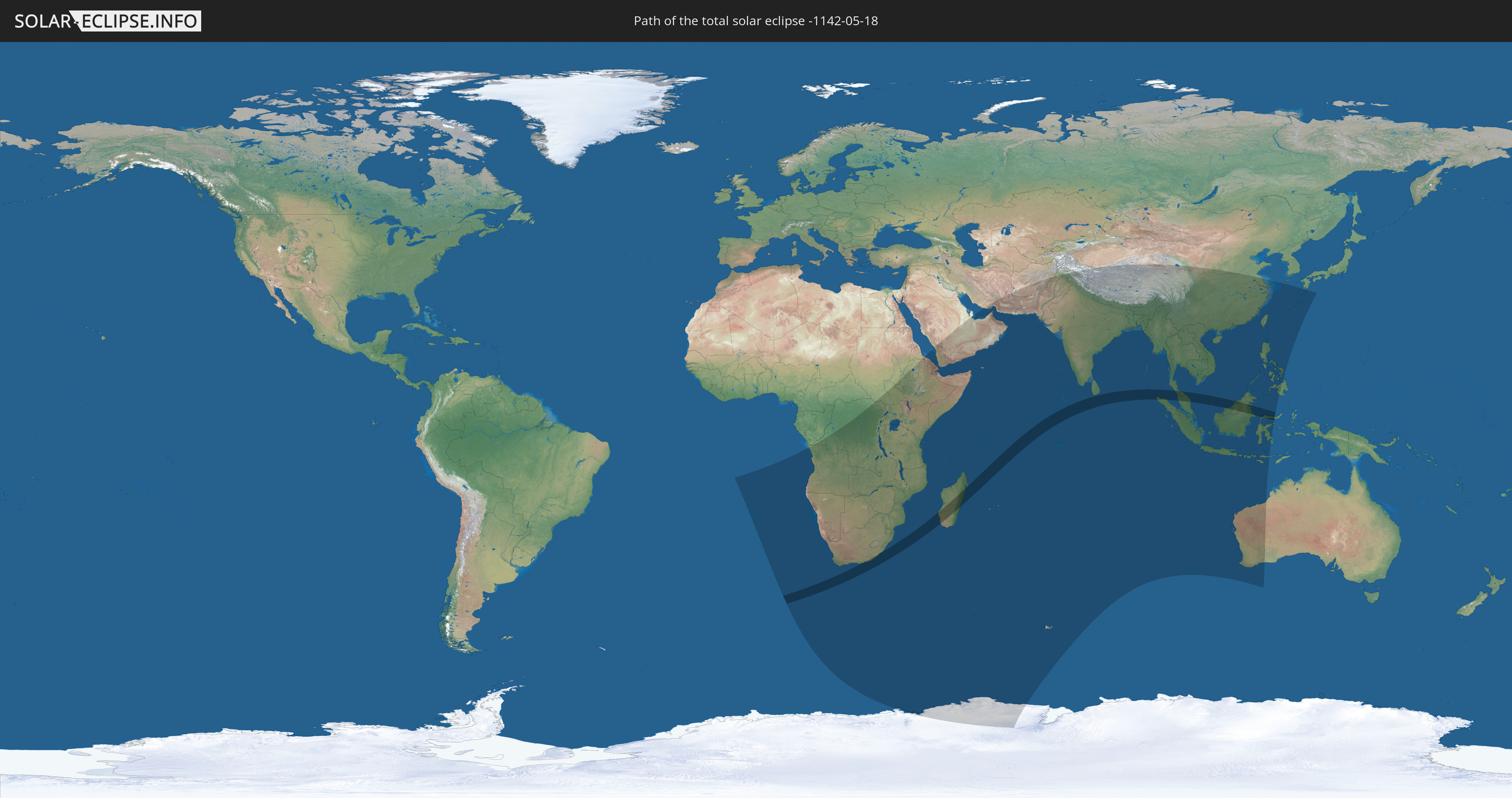
Die Sonnenfinsternis am 05/18/-1142 kann man in 62 Ländern als partielle Sonnenfinsternis beobachten.
Der Finsternispfad verläuft durch 9 Länder. Nur in diesen Ländern ist sie als total Sonnenfinsternis zu sehen.
In den folgenden Ländern ist die Sonnenfinsternis total zu sehen
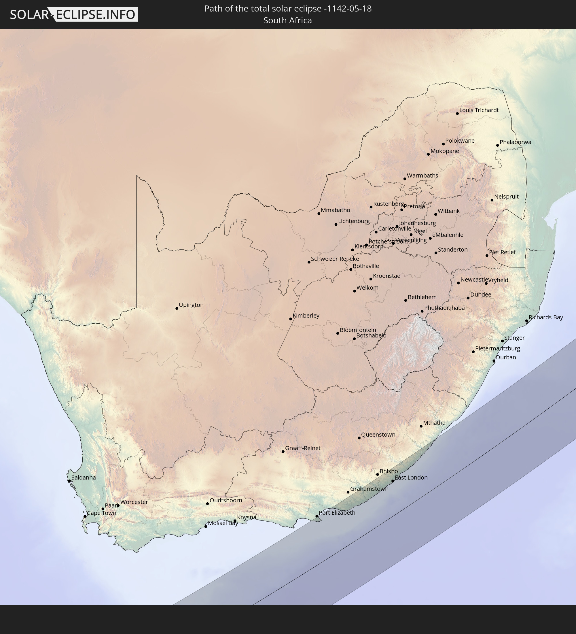 South Africa
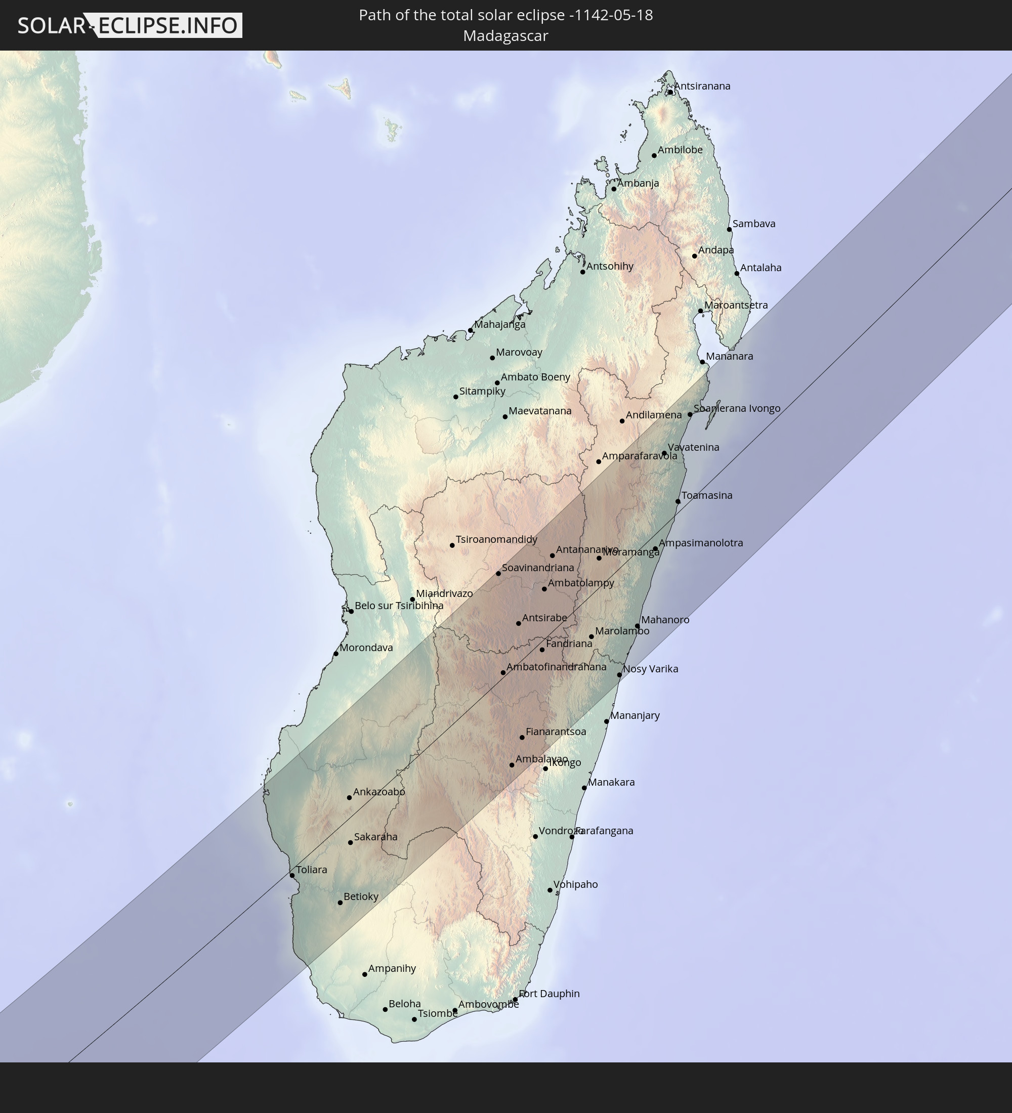 Madagascar
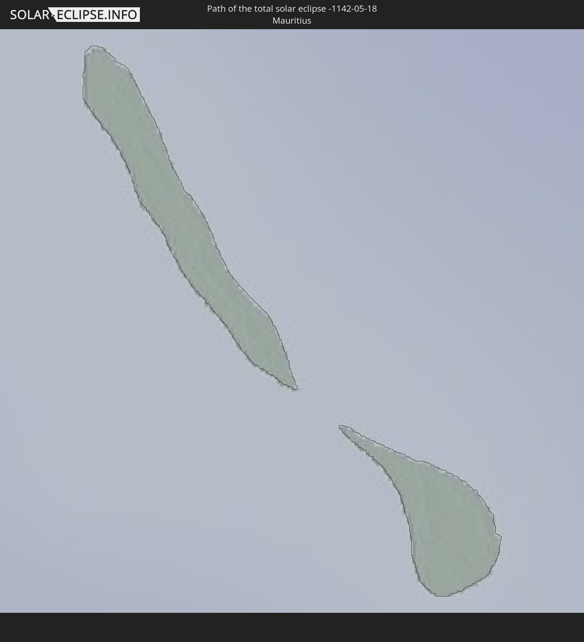 Mauritius
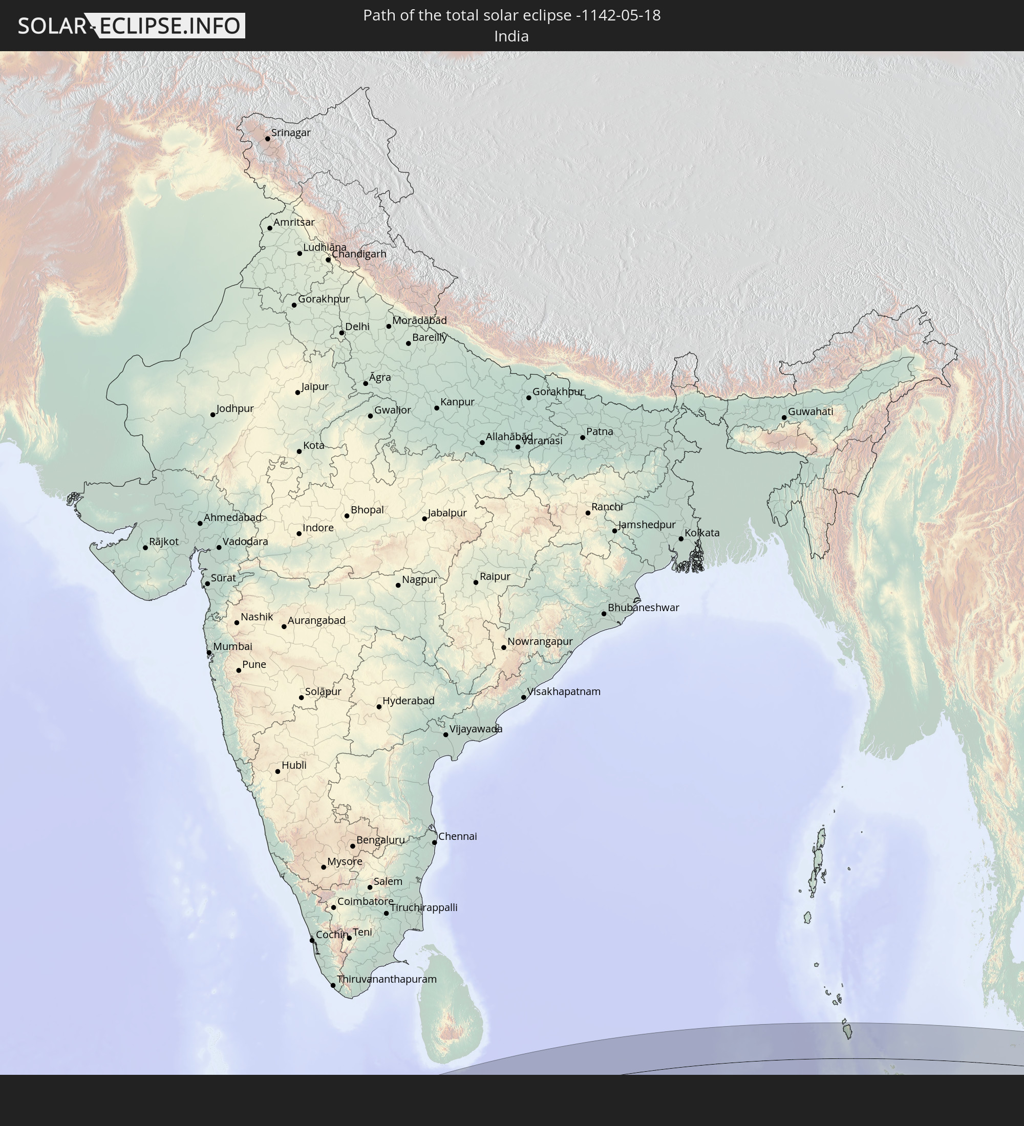 India
India
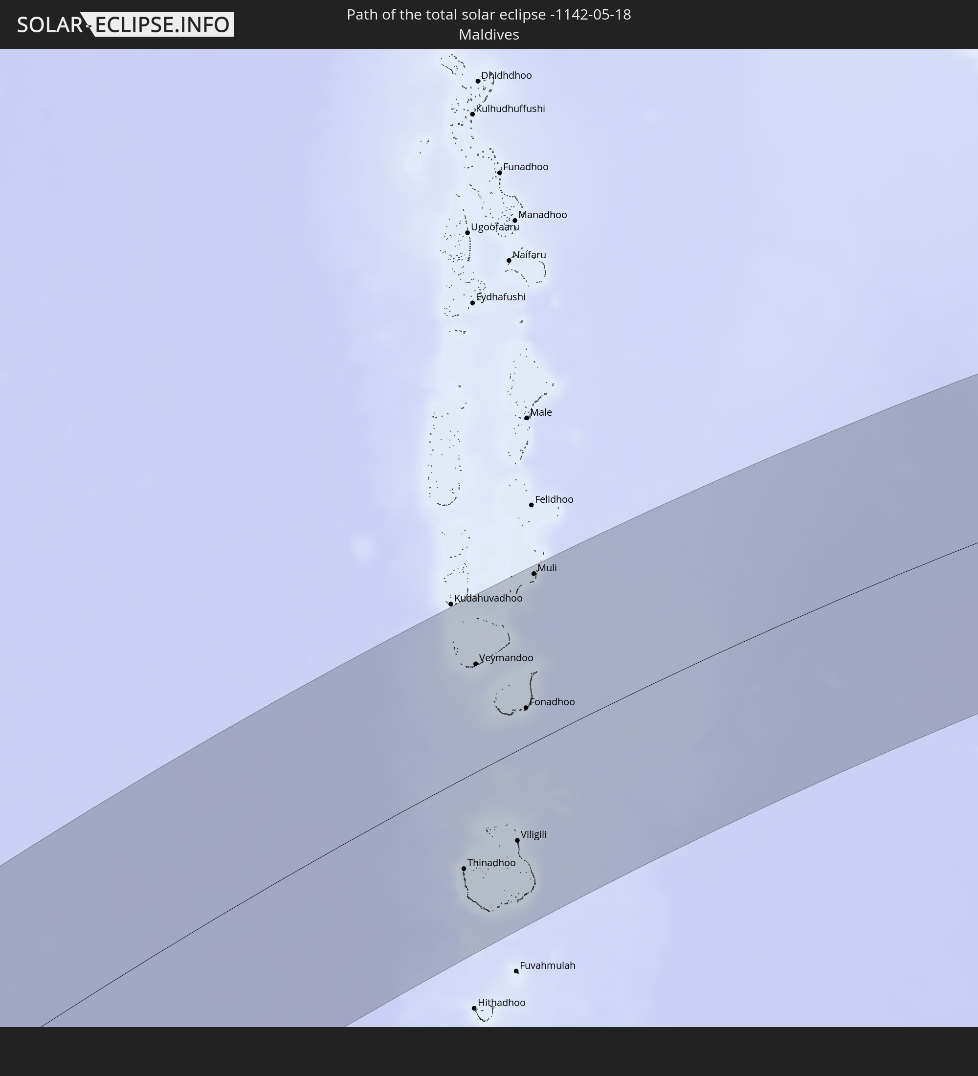 Maldives
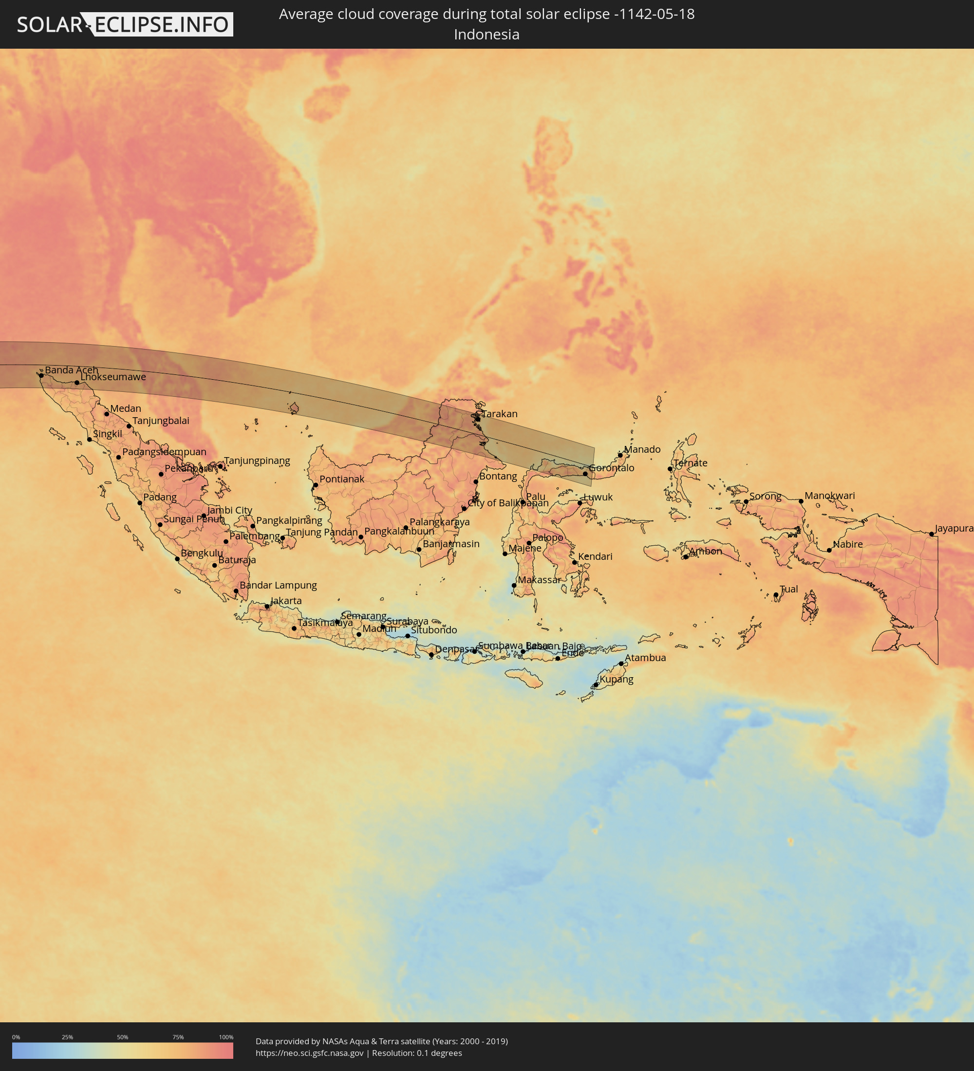
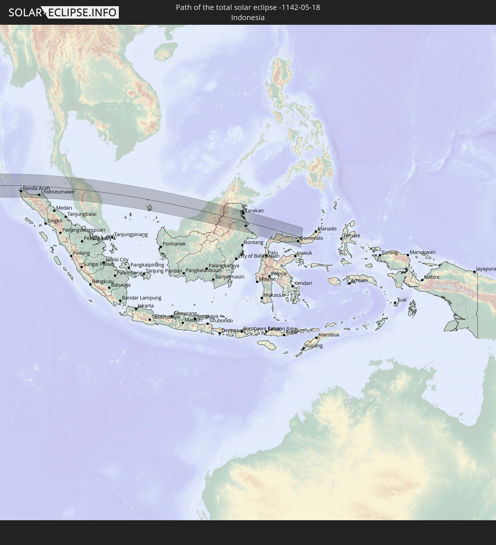 Indonesia
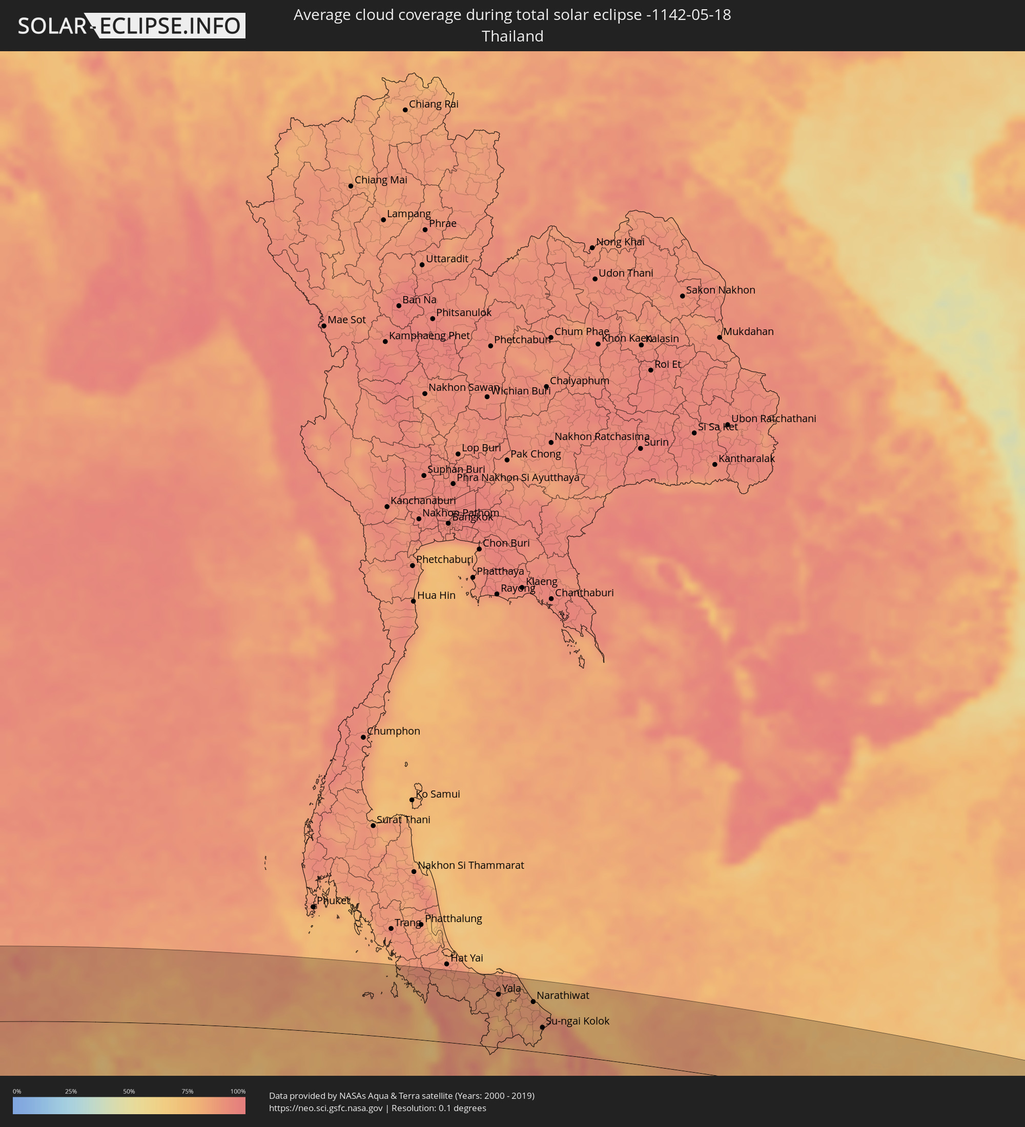
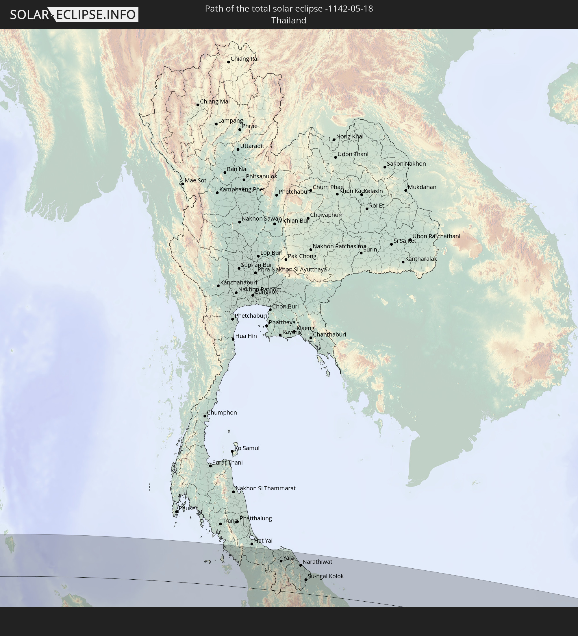 Thailand
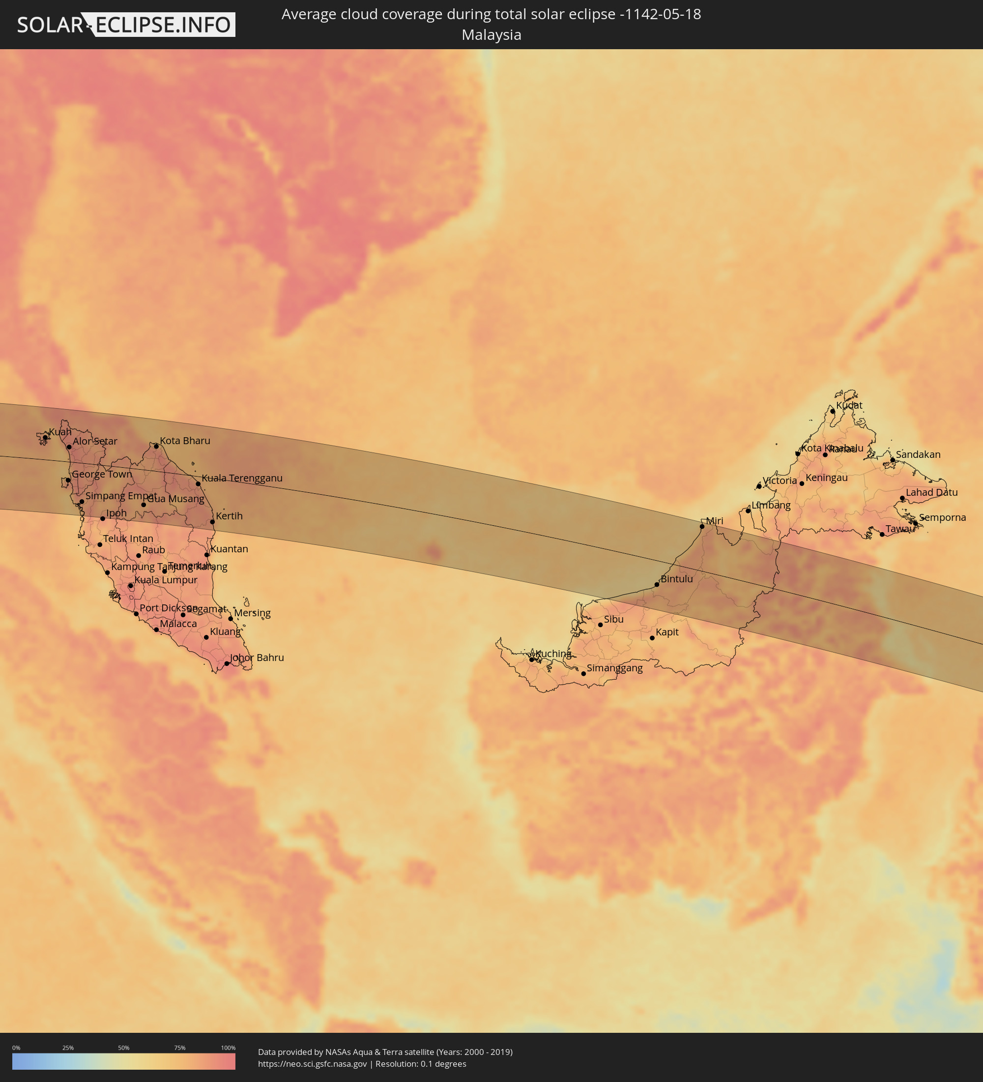
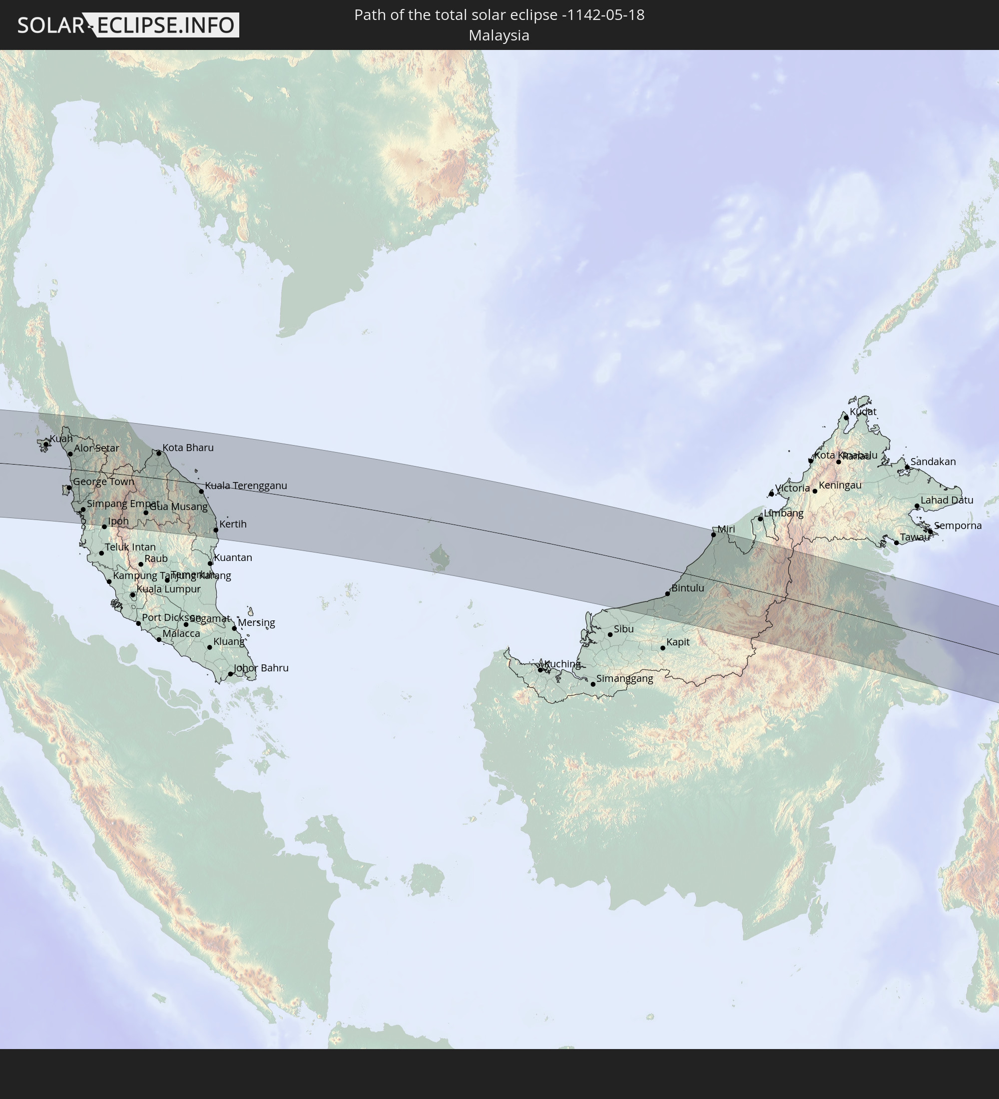 Malaysia
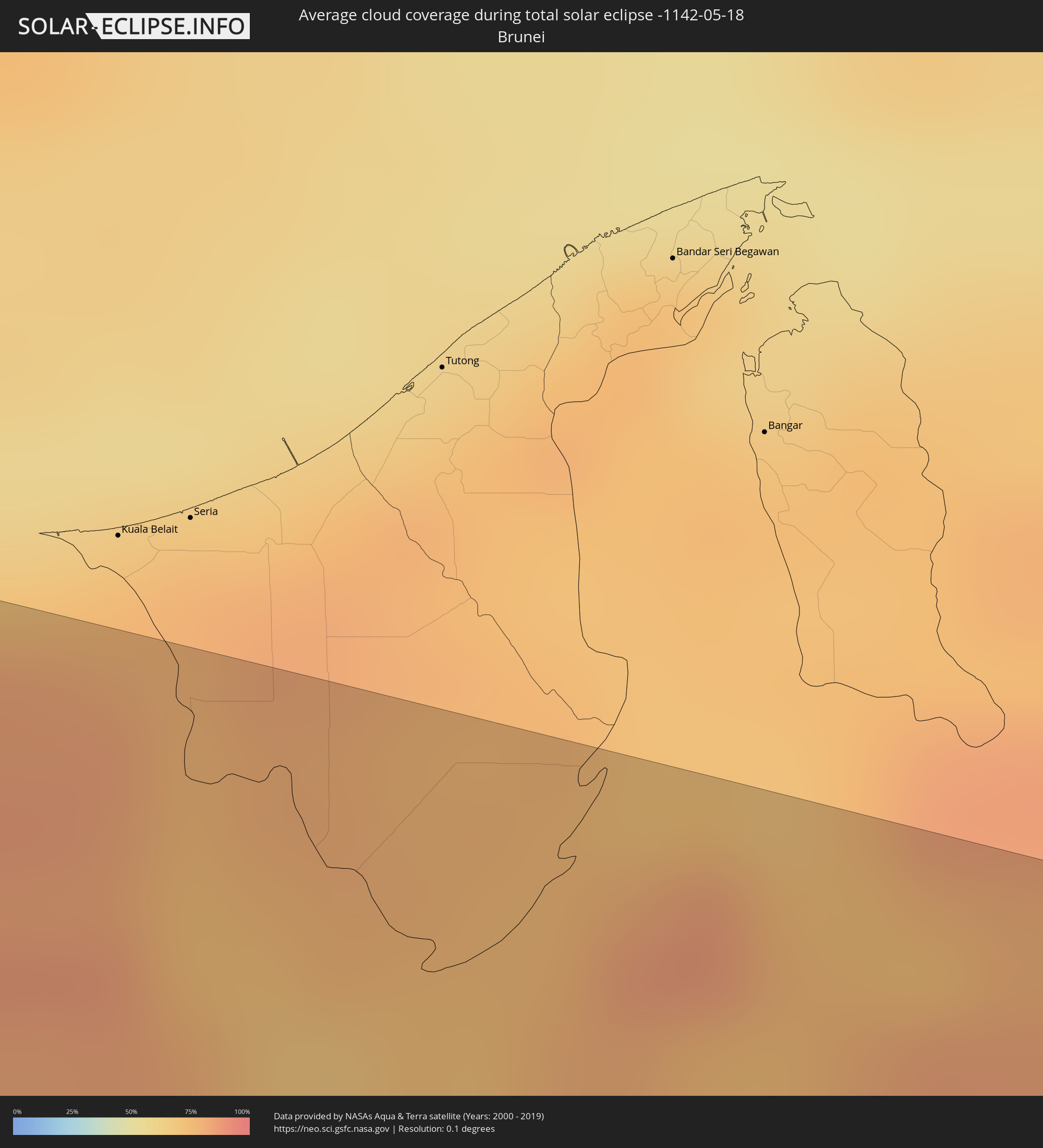
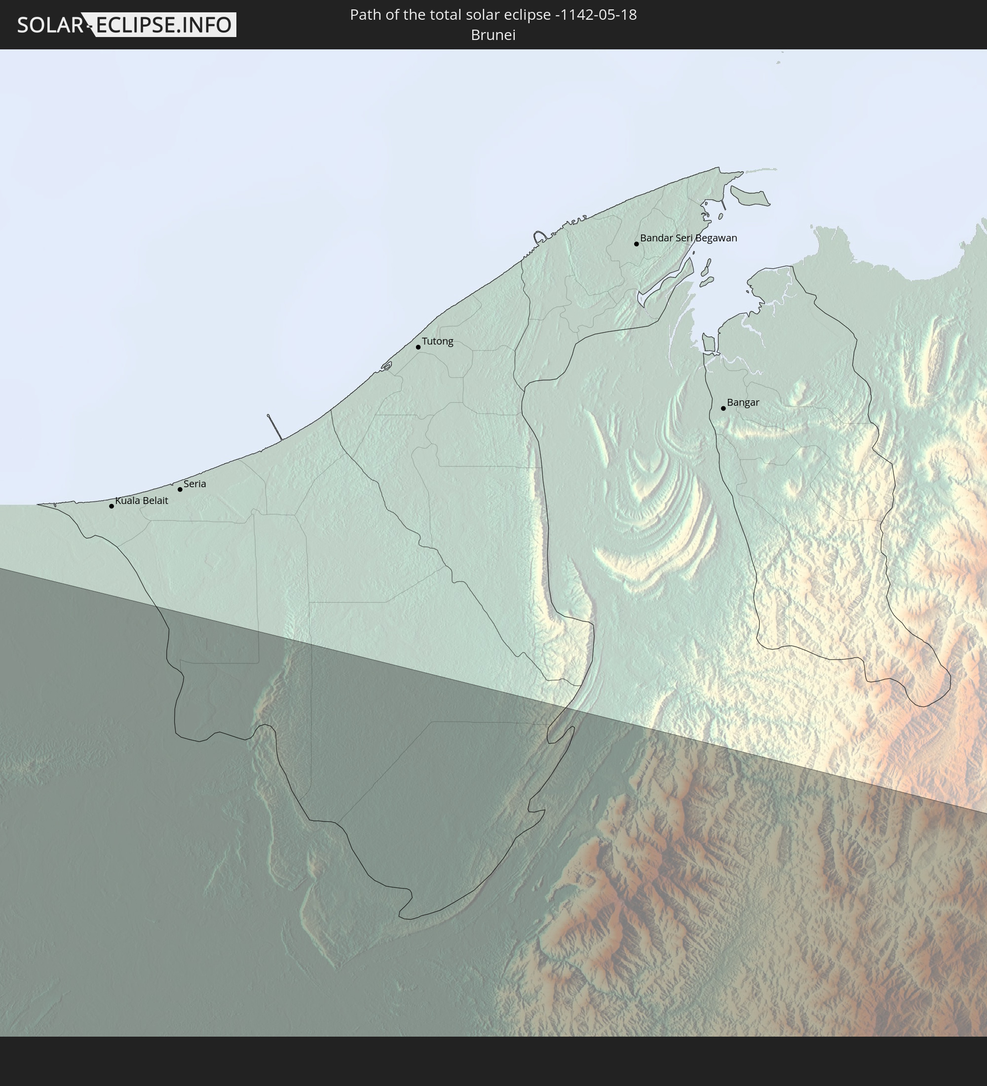 Brunei
In den folgenden Ländern ist die Sonnenfinsternis partiell zu sehen
 Antarctica
 Angola
 Namibia
 Democratic Republic of the Congo
 South Africa
 Botswana
 Zambia
 Zimbabwe
 Lesotho
 Rwanda
 Burundi
 Tanzania
 Uganda
 Mozambique
 Swaziland
 Malawi
 Ethiopia
 Kenya
Kenya
 Saudi Arabia
 Eritrea
 French Southern and Antarctic Lands
 Somalia
 Djibouti
 Yemen
Yemen
 Madagascar
 Comoros
 Iran
Iran
 Mayotte
 Seychelles
 Qatar
Qatar
 United Arab Emirates
 Oman
Oman
 Réunion
 Mauritius
 Afghanistan
 Pakistan
 India
India
 British Indian Ocean Territory
 Heard Island and McDonald Islands
 Maldives
 China
China
 Sri Lanka
 Nepal
Nepal
 Bangladesh
 Bhutan
 Myanmar
 Indonesia
 Cocos Islands
 Thailand
 Malaysia
 Laos
Laos
 Vietnam
 Cambodia
 Singapore
 Christmas Island
 Australia
 Macau
Macau
 Hong Kong
 Brunei
 Taiwan
 Philippines
 Japan
Japan
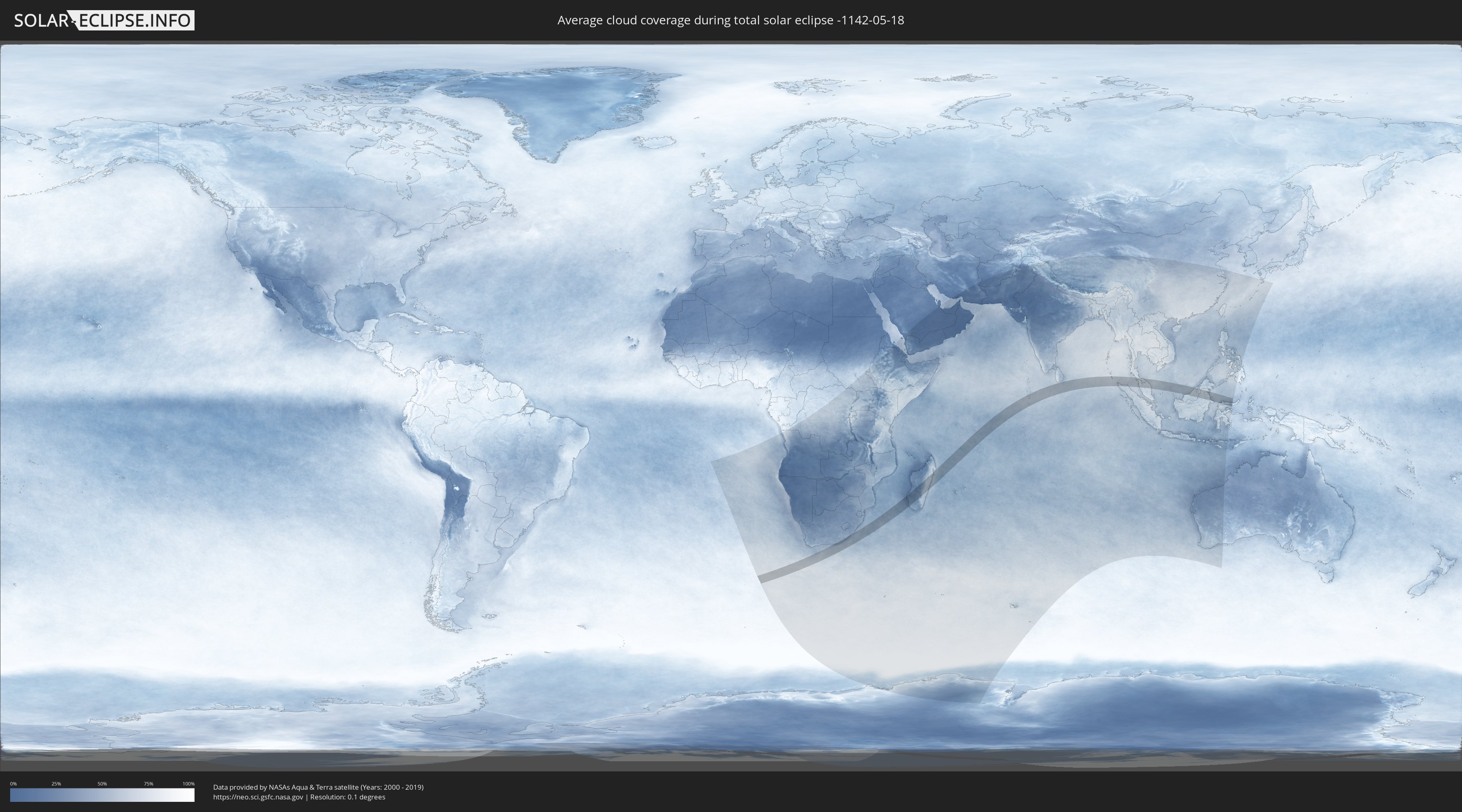
How will be the weather during the total solar eclipse on 05/18/-1142?
Where is the best place to see the total solar eclipse of 05/18/-1142?
The following maps show the average cloud coverage for the day of the total solar eclipse.
With the help of these maps, it is possible to find the place along the eclipse path, which has the best
chance of a cloudless sky.
Nevertheless, you should consider local circumstances and inform about the weather of your chosen
observation site.
The data is provided by NASAs satellites
AQUA and TERRA.
The cloud maps are averaged over a period of 19 years (2000 - 2019).

Detailed country maps
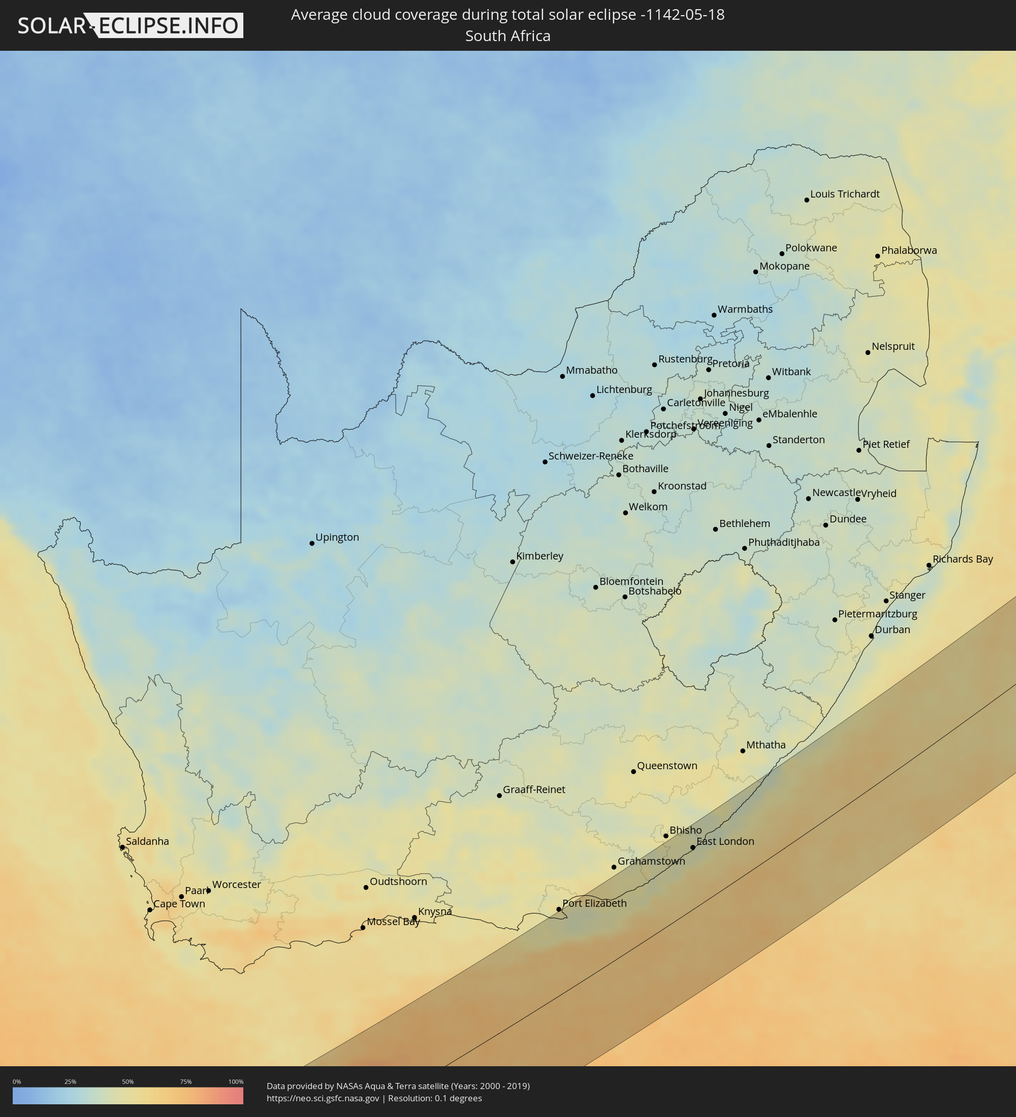 South Africa
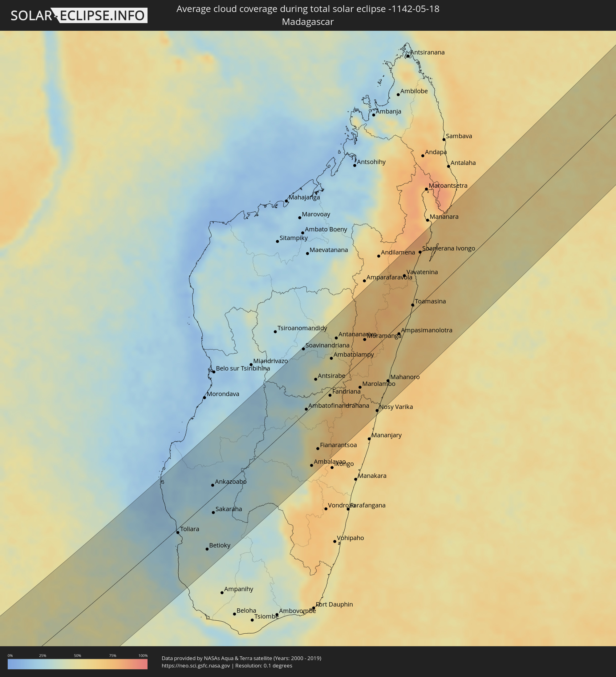 Madagascar
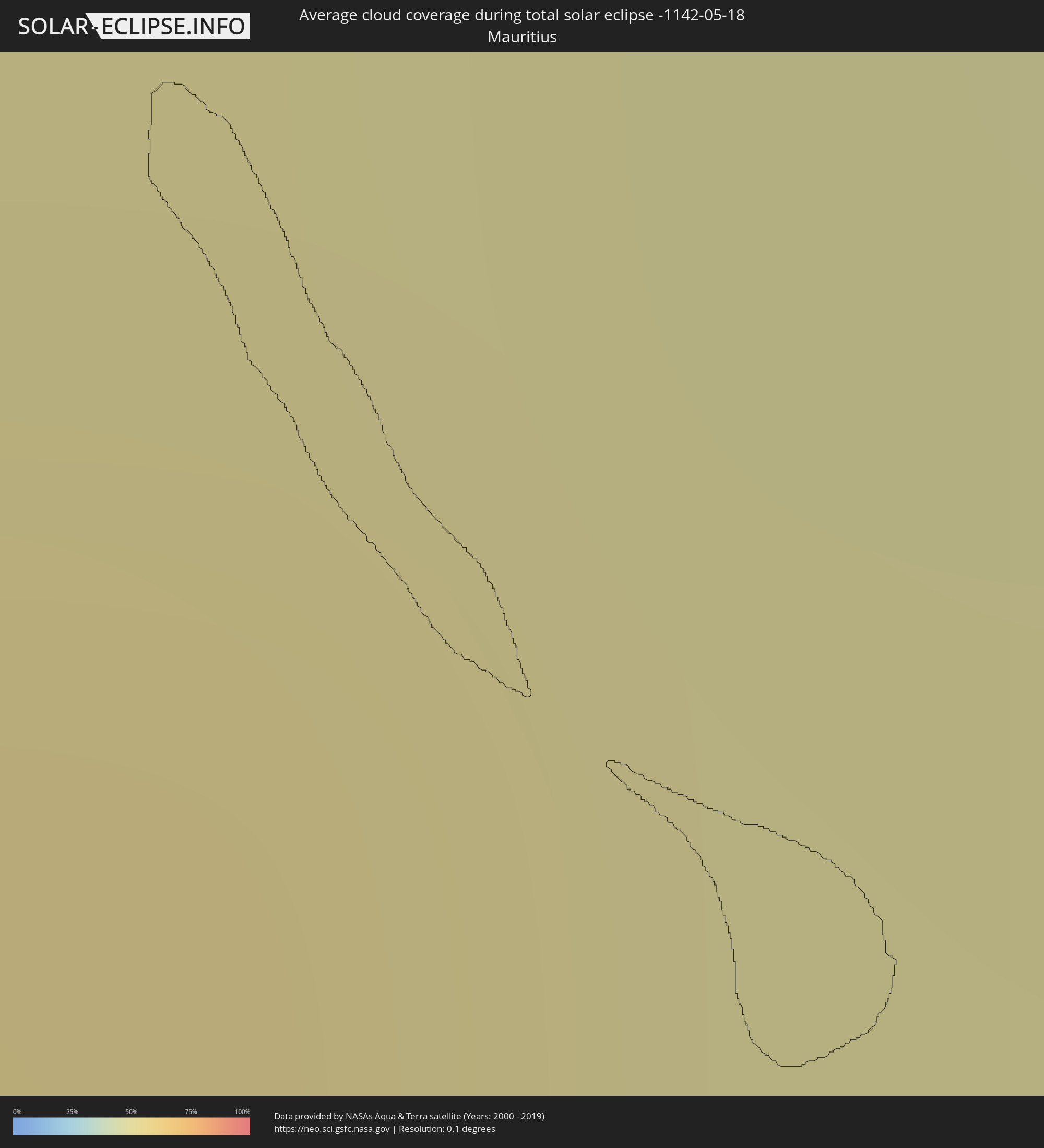 Mauritius
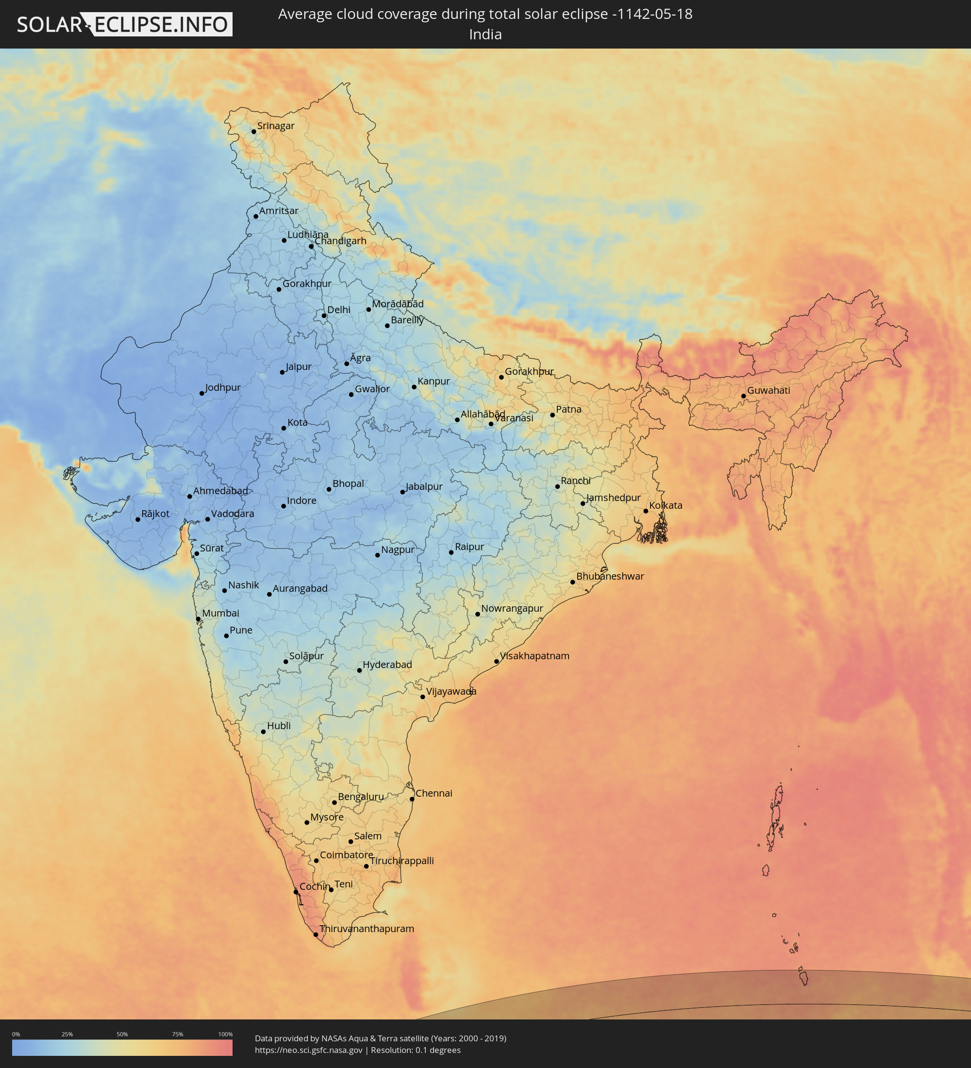 India
India
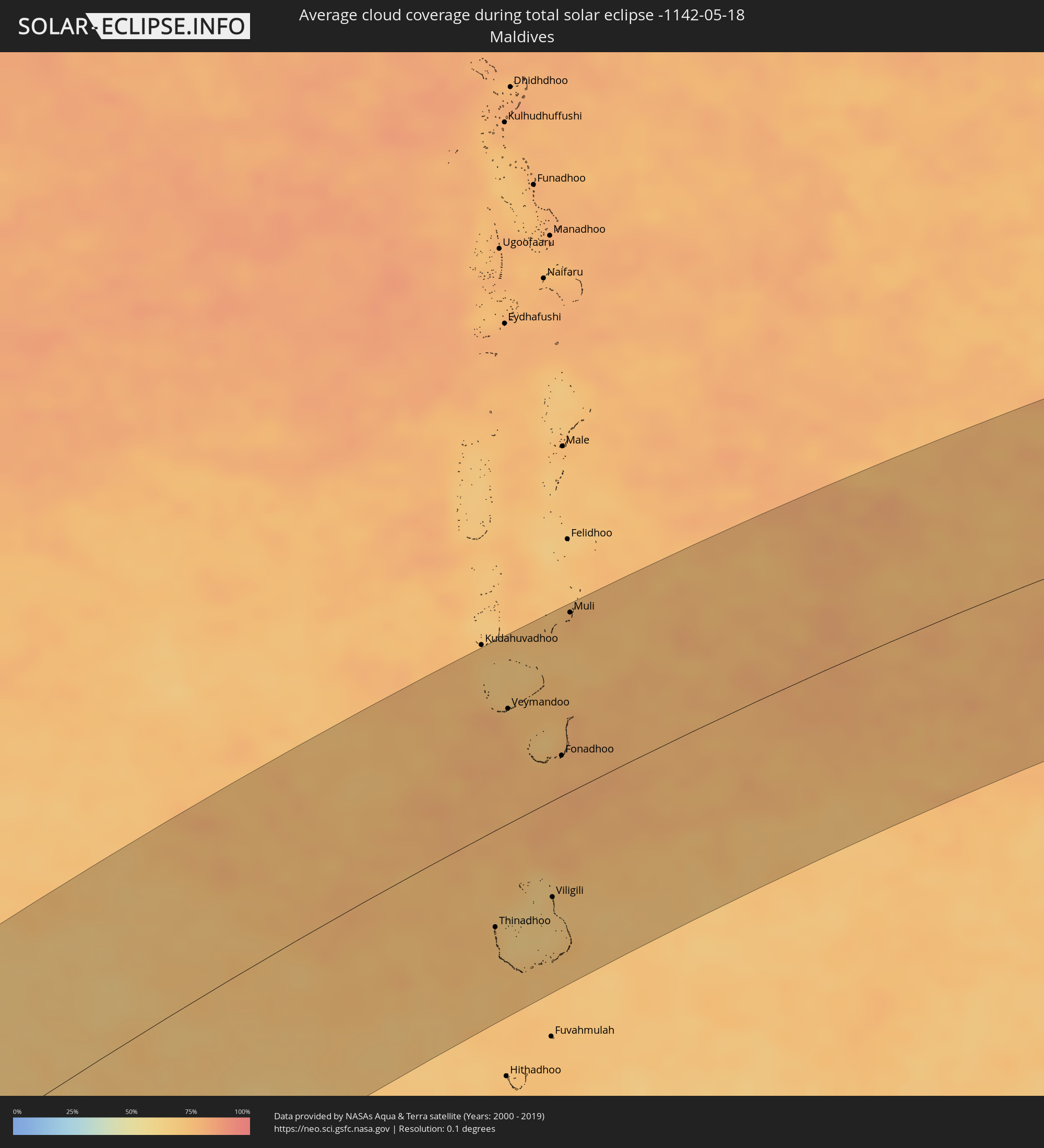 Maldives
 Indonesia
 Thailand
 Malaysia
 Brunei
Cities inside the path of the eclipse
The following table shows all locations with a population of more than 5,000 inside the eclipse path. Cities which have more than 100,000 inhabitants are marked bold. A click at the locations opens a detailed map.
| City | Type | Eclipse duration | Local time of max. eclipse | Distance to central line | Ø Cloud coverage |
|
Port Alfred, Eastern Cape
|
total | - | 08:04:01 UTC+01:30 | 82 km | 47% |
|
East London, Eastern Cape
|
total | - | 08:04:47 UTC+01:30 | 83 km | 44% |
|
Toliara, Atsimo-Andrefana
|
total | - | 09:22:16 UTC+02:27 | 8 km | 31% |
|
Betioky, Atsimo-Andrefana
|
total | - | 09:22:56 UTC+02:27 | 88 km | 35% |
|
Ankazoabo, Atsimo-Andrefana
|
total | - | 09:24:19 UTC+02:27 | 22 km | 22% |
|
Sakaraha, Atsimo-Andrefana
|
total | - | 09:23:49 UTC+02:27 | 30 km | 31% |
|
Beroroha, Atsimo-Andrefana
|
total | - | 09:25:47 UTC+02:27 | 28 km | 22% |
|
Soavinandriana, Itasy
|
total | - | 09:30:33 UTC+02:27 | 122 km | 28% |
|
Miandrarivo, Vakinankaratra
|
total | - | 09:30:18 UTC+02:27 | 99 km | 32% |
|
Ambatofinandrahana, Amoron'i Mania
|
total | - | 09:29:14 UTC+02:27 | 4 km | 43% |
|
Betafo, Vakinankaratra
|
total | - | 09:30:02 UTC+02:27 | 59 km | 33% |
|
Ambalavao, Upper Matsiatra
|
total | - | 09:28:11 UTC+02:27 | 109 km | 46% |
|
Faratsiho, Vakinankaratra
|
total | - | 09:30:38 UTC+02:27 | 88 km | 35% |
|
Antsirabe, Vakinankaratra
|
total | - | 09:30:17 UTC+02:27 | 44 km | 38% |
|
Fianarantsoa, Upper Matsiatra
|
total | - | 09:28:46 UTC+02:27 | 89 km | 68% |
|
Arivonimamo, Itasy
|
total | - | 09:31:24 UTC+02:27 | 102 km | 31% |
|
Soanindrariny, Vakinankaratra
|
total | - | 09:30:33 UTC+02:27 | 27 km | 45% |
|
Ambositra, Amoron'i Mania
|
total | - | 09:29:55 UTC+02:27 | 25 km | 57% |
|
Antanifotsy, Vakinankaratra
|
total | - | 09:30:56 UTC+02:27 | 41 km | 43% |
|
Fandriana, Amoron'i Mania
|
total | - | 09:30:26 UTC+02:27 | 11 km | 55% |
|
Ambatolampy, Vakinankaratra
|
total | - | 09:31:22 UTC+02:27 | 56 km | 46% |
|
Antananarivo, Analamanga
|
total | - | 09:32:03 UTC+02:27 | 85 km | 48% |
|
Manjakandriana, Analamanga
|
total | - | 09:32:28 UTC+02:27 | 66 km | 62% |
|
Anjozorobe, Analamanga
|
total | - | 09:33:08 UTC+02:27 | 103 km | 66% |
|
Marolambo, Atsinanana
|
total | - | 09:31:45 UTC+02:27 | 49 km | 68% |
|
Moramanga, Alaotra Mangoro
|
total | - | 09:33:06 UTC+02:27 | 32 km | 73% |
|
Sahavato, Vatovavy Fitovinany
|
total | - | 09:31:31 UTC+02:27 | 109 km | 67% |
|
Ambatondrazaka, Alaotra Mangoro
|
total | - | 09:34:39 UTC+02:27 | 109 km | 63% |
|
Nosy Varika, Vatovavy Fitovinany
|
total | - | 09:31:50 UTC+02:27 | 122 km | 56% |
|
Mahanoro, Atsinanana
|
total | - | 09:32:58 UTC+02:27 | 86 km | 57% |
|
Vohibinany, Atsinanana
|
total | - | 09:36:13 UTC+02:27 | 103 km | 73% |
|
Ampasimanolotra, Atsinanana
|
total | - | 09:34:35 UTC+02:27 | 18 km | 58% |
|
Vavatenina, Analanjirofo
|
total | - | 09:36:21 UTC+02:27 | 81 km | 73% |
|
Toamasina, Atsinanana
|
total | - | 09:35:53 UTC+02:27 | 11 km | 57% |
|
Fenoarivo Atsinanana, Analanjirofo
|
total | - | 09:36:47 UTC+02:27 | 73 km | 64% |
|
Soanierana Ivongo, Analanjirofo
|
total | - | 09:37:38 UTC+02:27 | 97 km | 64% |
|
Thinadhoo, Gaafu Dhaalu Atholhu
|
total | - | 13:22:42 UTC+04:54 | 72 km | 73% |
|
Veymandoo, Thaa Atholhu
|
total | - | 13:25:29 UTC+04:54 | 86 km | 75% |
|
Viligili, Gaafu Alifu Atholhu
|
total | - | 13:24:07 UTC+04:54 | 72 km | 67% |
|
Fonadhoo, Laamu
|
total | - | 13:25:55 UTC+04:54 | 30 km | 76% |
|
Muli, Meemu Atholhu
|
total | - | 13:27:42 UTC+04:54 | 135 km | 77% |
|
Sabang, Aceh
|
total | - | 16:27:37 UTC+07:07 | 25 km | 70% |
|
Banda Aceh, Aceh
|
total | - | 16:27:24 UTC+07:07 | 64 km | 73% |
|
Sigli, Aceh
|
total | - | 16:28:11 UTC+07:07 | 79 km | 74% |
|
Reuleuet, Aceh
|
total | - | 16:28:31 UTC+07:07 | 97 km | 80% |
|
Bireun, Aceh
|
total | - | 16:29:05 UTC+07:07 | 97 km | 78% |
|
Lhokseumawe, Aceh
|
total | - | 16:29:40 UTC+07:07 | 97 km | 78% |
|
Kuah, Kedah
|
total | - | 16:21:58 UTC+06:55 | 51 km | 84% |
|
Satun, Satun
|
total | - | 16:09:02 UTC+06:42 | 86 km | 82% |
|
Kangar, Perlis
|
total | - | 16:22:26 UTC+06:55 | 68 km | 88% |
|
Kuala Kedah, Kedah
|
total | - | 16:22:21 UTC+06:55 | 31 km | 75% |
|
Tanjung Tokong, Penang
|
total | - | 16:21:59 UTC+06:55 | 40 km | 84% |
|
George Town, Penang
|
total | - | 16:22:00 UTC+06:55 | 45 km | 86% |
|
Alor Setar, Kedah
|
total | - | 16:22:26 UTC+06:55 | 34 km | 91% |
|
Butterworth, Penang
|
total | - | 16:22:01 UTC+06:55 | 46 km | 86% |
|
Permatang Kuching, Penang
|
total | - | 16:22:05 UTC+06:55 | 39 km | 87% |
|
Perai, Penang
|
total | - | 16:22:02 UTC+06:55 | 48 km | 86% |
|
Jitra, Kedah
|
total | - | 16:22:35 UTC+06:55 | 51 km | 92% |
|
Sadao, Songkhla
|
total | - | 16:09:27 UTC+06:42 | 92 km | 87% |
|
Kepala Batas, Penang
|
total | - | 16:22:10 UTC+06:55 | 32 km | 87% |
|
Bukit Mertajam, Penang
|
total | - | 16:22:07 UTC+06:55 | 49 km | 91% |
|
Gurun, Kedah
|
total | - | 16:22:23 UTC+06:55 | 1 km | 89% |
|
Nibong Tebal, Penang
|
total | - | 16:22:01 UTC+06:55 | 71 km | 89% |
|
Sungai Petani, Kedah
|
total | - | 16:22:18 UTC+06:55 | 17 km | 90% |
|
Parit Buntar, Perak
|
total | - | 16:22:00 UTC+06:55 | 75 km | 83% |
|
Bedong, Kedah
|
total | - | 16:22:23 UTC+06:55 | 8 km | 89% |
|
Bagan Serai, Perak
|
total | - | 16:21:59 UTC+06:55 | 87 km | 76% |
|
Simpang Empat, Perak
|
total | - | 16:22:03 UTC+06:55 | 93 km | 82% |
|
Taiping, Perak
|
total | - | 16:22:07 UTC+06:55 | 103 km | 86% |
|
Kuala Kangsar, Perak
|
total | - | 16:22:17 UTC+06:55 | 110 km | 83% |
|
Betong, Yala
|
total | - | 16:09:41 UTC+06:42 | 3 km | 80% |
|
Nong Chik, Pattani
|
total | - | 16:10:23 UTC+06:42 | 123 km | 89% |
|
Yala, Yala
|
total | - | 16:10:20 UTC+06:42 | 90 km | 84% |
|
Sai Buri, Pattani
|
total | - | 16:10:47 UTC+06:42 | 112 km | 82% |
|
Ra-ngae, Narathiwat
|
total | - | 16:10:41 UTC+06:42 | 69 km | 84% |
|
Narathiwat, Narathiwat
|
total | - | 16:10:51 UTC+06:42 | 84 km | 85% |
|
Ban Su-ngai Pa Di, Narathiwat
|
total | - | 16:10:43 UTC+06:42 | 46 km | 84% |
|
Gua Musang, Kelantan
|
total | - | 16:23:29 UTC+06:55 | 85 km | 82% |
|
Su-ngai Kolok, Narathiwat
|
total | - | 16:10:47 UTC+06:42 | 42 km | 81% |
|
Tak Bai, Narathiwat
|
total | - | 16:11:00 UTC+06:42 | 69 km | 80% |
|
Pasir Mas, Kelantan
|
total | - | 16:24:20 UTC+06:55 | 47 km | 83% |
|
Tanah Merah, Kelantan
|
total | - | 16:24:12 UTC+06:55 | 19 km | 82% |
|
Kampong Pangkal Kalong, Kelantan
|
total | - | 16:24:20 UTC+06:55 | 33 km | 84% |
|
Kota Bharu, Kelantan
|
total | - | 16:24:29 UTC+06:55 | 57 km | 87% |
|
Kampong Kadok, Kelantan
|
total | - | 16:24:25 UTC+06:55 | 43 km | 92% |
|
Peringat, Kelantan
|
total | - | 16:24:28 UTC+06:55 | 47 km | 92% |
|
Kuala Terengganu, Terengganu
|
total | - | 16:24:58 UTC+06:55 | 19 km | 88% |
|
Marang, Terengganu
|
total | - | 16:24:58 UTC+06:55 | 32 km | 86% |
|
Paka, Terengganu
|
total | - | 16:24:52 UTC+06:55 | 91 km | 85% |
|
Kertih, Terengganu
|
total | - | 16:24:49 UTC+06:55 | 105 km | 84% |
|
Bintulu, Sarawak
|
total | - | 16:57:21 UTC+07:21 | 57 km | 72% |
|
Miri, Sarawak
|
total | - | 16:58:24 UTC+07:21 | 103 km | 77% |
|
Tanjung Selor, North Kalimantan
|
total | - | 17:35:23 UTC+07:57 | 23 km | 80% |
|
Tarakan, North Kalimantan
|
total | - | 17:35:41 UTC+07:57 | 80 km | 68% |
|
Gorontalo, Gorontalo
|
total | - | 17:35:47 UTC+07:57 | 52 km | 55% |