Total solar eclipse of 10/30/-1244
| Day of week: | Monday |
| Maximum duration of eclipse: | 02m48s |
| Maximum width of eclipse path: | 165 km |
| Saros cycle: | 23 |
| Coverage: | 100% |
| Magnitude: | 1.0377 |
| Gamma: | -0.6452 |
Wo kann man die Sonnenfinsternis vom 10/30/-1244 sehen?
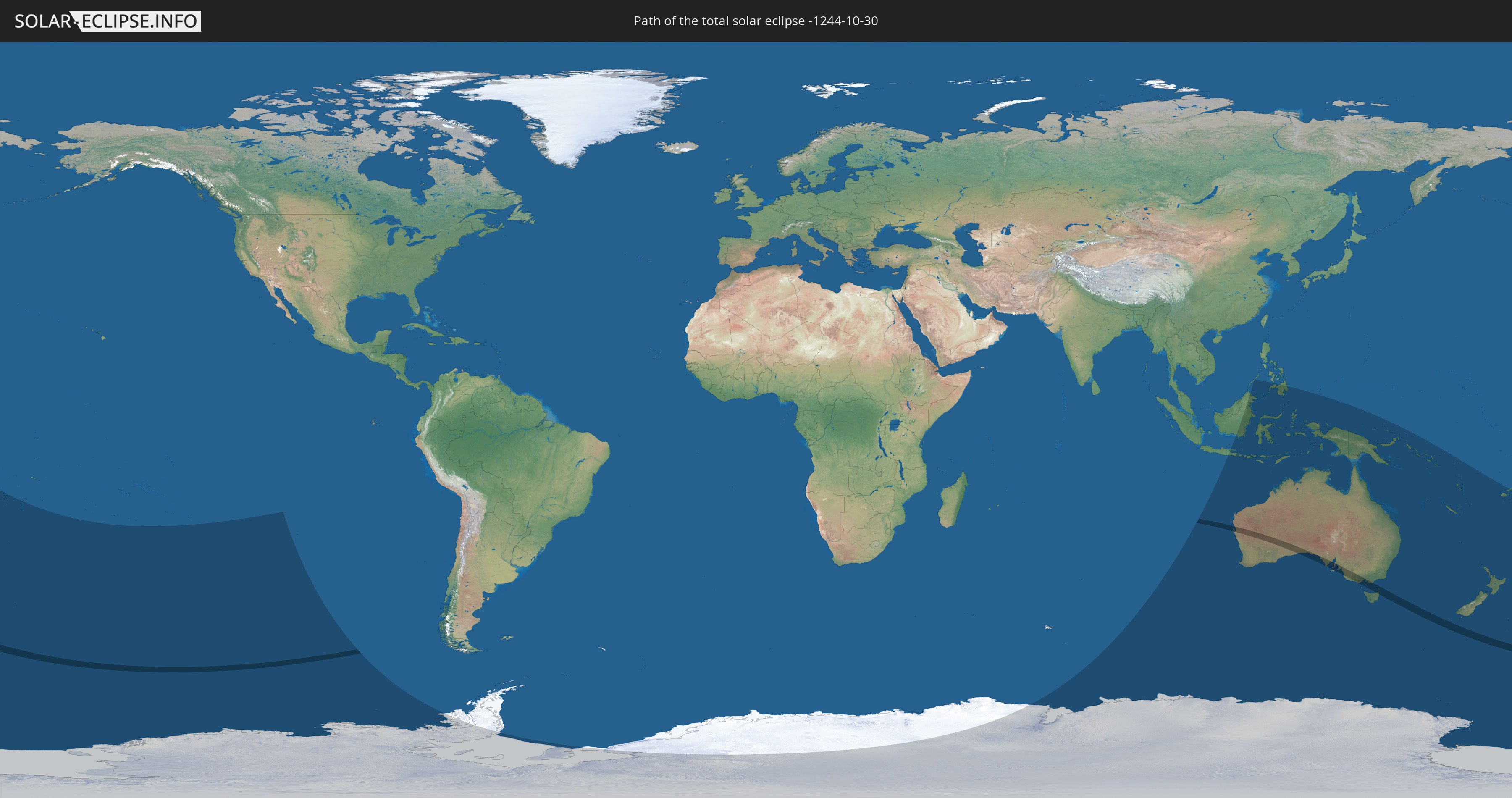
Die Sonnenfinsternis am 10/30/-1244 kann man in 17 Ländern als partielle Sonnenfinsternis beobachten.
Der Finsternispfad verläuft durch ein Land. Nur in diesem Land ist sie als total Sonnenfinsternis zu sehen.
In den folgenden Ländern ist die Sonnenfinsternis total zu sehen
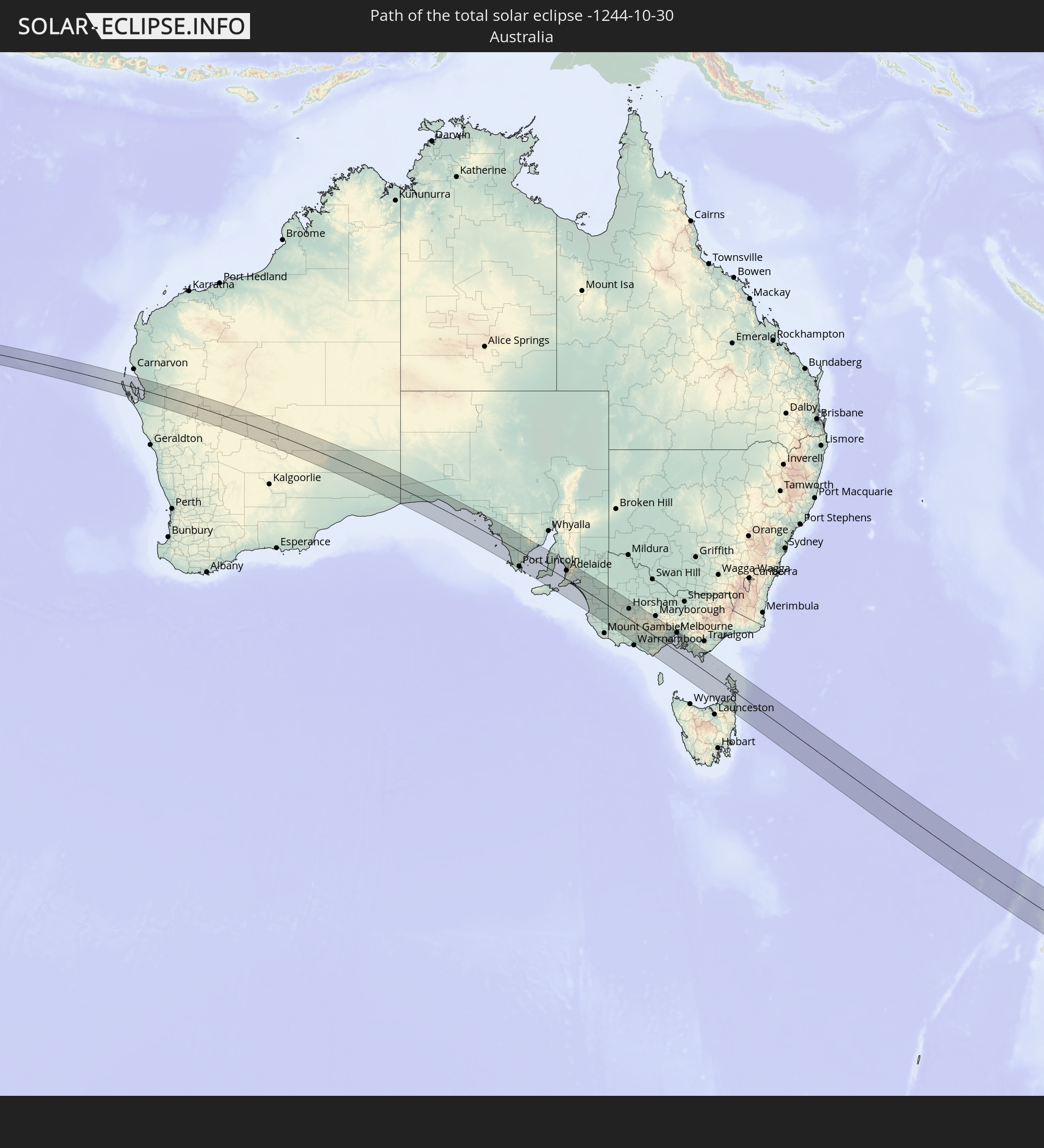 Australia
In den folgenden Ländern ist die Sonnenfinsternis partiell zu sehen


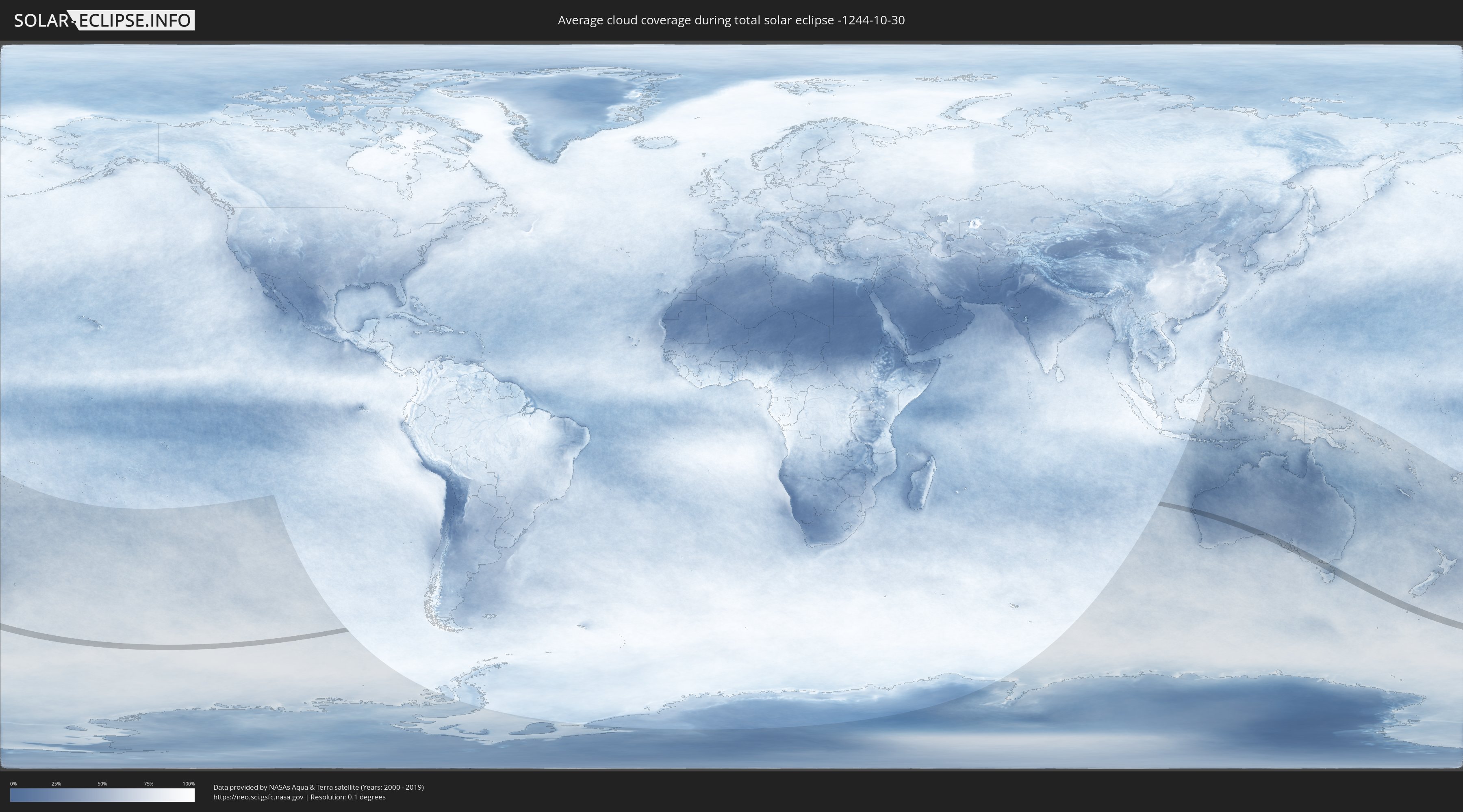
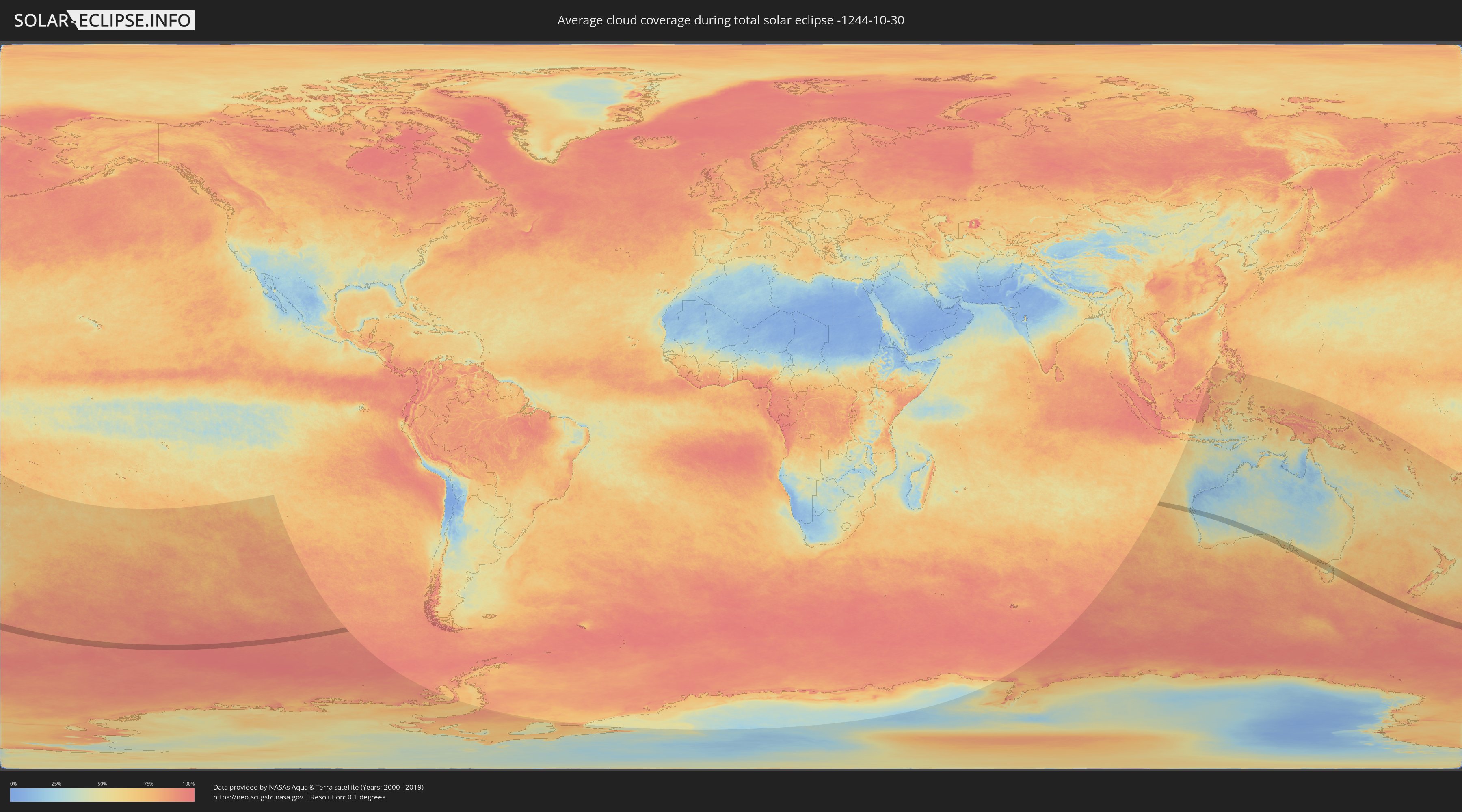
How will be the weather during the total solar eclipse on 10/30/-1244?
Where is the best place to see the total solar eclipse of 10/30/-1244?
The following maps show the average cloud coverage for the day of the total solar eclipse.
With the help of these maps, it is possible to find the place along the eclipse path, which has the best
chance of a cloudless sky.
Nevertheless, you should consider local circumstances and inform about the weather of your chosen
observation site.
The data is provided by NASAs satellites
AQUA and TERRA.
The cloud maps are averaged over a period of 19 years (2000 - 2019).
Detailed country maps
 Australia
Cities inside the path of the eclipse
The following table shows all locations with a population of more than 5,000 inside the eclipse path. Cities which have more than 100,000 inhabitants are marked bold. A click at the locations opens a detailed map.
| City | Type | Eclipse duration | Local time of max. eclipse | Distance to central line | Ø Cloud coverage |
 Port Lincoln, South Australia
|
total | - | 08:24:26 UTC+09:30 | 70 km | 66% |
|
Aldinga, South Australia
|
total | - | 08:27:29 UTC+09:30 | 1 km | 62% |
|
Grange, South Australia
|
total | - | 08:26:50 UTC+09:30 | 36 km | 57% |
|
Henley Beach, South Australia
|
total | - | 08:26:52 UTC+09:30 | 34 km | 57% |
|
Seaton, South Australia
|
total | - | 08:26:51 UTC+09:30 | 37 km | 57% |
|
Morphett Vale, South Australia
|
total | - | 08:27:15 UTC+09:30 | 15 km | 59% |
|
Findon, South Australia
|
total | - | 08:26:52 UTC+09:30 | 38 km | 57% |
|
Happy Valley, South Australia
|
total | - | 08:27:11 UTC+09:30 | 21 km | 59% |
|
North Adelaide, South Australia
|
total | - | 08:26:56 UTC+09:30 | 40 km | 57% |
|
Prospect, South Australia
|
total | - | 08:26:54 UTC+09:30 | 43 km | 57% |
|
Adelaide, South Australia
|
total | - | 08:26:59 UTC+09:30 | 39 km | 57% |
|
Victor Harbor, South Australia
|
total | - | 08:28:04 UTC+09:30 | 19 km | 65% |
|
Salisbury, South Australia
|
total | - | 08:26:44 UTC+09:30 | 56 km | 55% |
|
Ingle Farm, South Australia
|
total | - | 08:26:51 UTC+09:30 | 49 km | 55% |
|
Klemzig, South Australia
|
total | - | 08:26:55 UTC+09:30 | 45 km | 57% |
|
Campbelltown, South Australia
|
total | - | 08:26:57 UTC+09:30 | 46 km | 56% |
|
Paradise, South Australia
|
total | - | 08:26:57 UTC+09:30 | 47 km | 56% |
|
Modbury, South Australia
|
total | - | 08:26:53 UTC+09:30 | 52 km | 53% |
|
Athelstone, South Australia
|
total | - | 08:26:58 UTC+09:30 | 49 km | 56% |
|
Hope Valley, South Australia
|
total | - | 08:26:54 UTC+09:30 | 53 km | 53% |
|
Adelaide Hills, South Australia
|
total | - | 08:27:02 UTC+09:30 | 45 km | 56% |
|
Golden Grove, South Australia
|
total | - | 08:26:51 UTC+09:30 | 59 km | 53% |
|
Gawler, South Australia
|
total | - | 08:26:33 UTC+09:30 | 77 km | 55% |
|
Mount Barker, South Australia
|
total | - | 08:27:27 UTC+09:30 | 38 km | 58% |
|
Murray Bridge, South Australia
|
total | - | 08:27:53 UTC+09:30 | 53 km | 55% |
|
Naracoorte, South Australia
|
total | - | 08:32:23 UTC+09:30 | 50 km | 71% |
|
Hamilton, Victoria
|
total | - | 09:04:58 UTC+10:00 | 60 km | 71% |
|
Horsham, Victoria
|
total | - | 09:03:21 UTC+10:00 | 45 km | 57% |
|
Stawell, Victoria
|
total | - | 09:04:31 UTC+10:00 | 41 km | 59% |
|
Ararat, Victoria
|
total | - | 09:05:04 UTC+10:00 | 27 km | 64% |
|
Colac, Victoria
|
total | - | 09:07:34 UTC+10:00 | 38 km | 72% |
|
Sebastopol, Victoria
|
total | - | 09:06:31 UTC+10:00 | 44 km | 67% |
|
Ballarat, Victoria
|
total | - | 09:06:29 UTC+10:00 | 46 km | 67% |
|
Ballarat Central, Victoria
|
total | - | 09:06:29 UTC+10:00 | 46 km | 67% |
|
Hamlyn Heights, Victoria
|
total | - | 09:07:57 UTC+10:00 | 18 km | 71% |
|
Bell Park, Victoria
|
total | - | 09:07:56 UTC+10:00 | 20 km | 71% |
|
Geelong West, Victoria
|
total | - | 09:08:00 UTC+10:00 | 18 km | 71% |
|
Geelong, Victoria
|
total | - | 09:08:02 UTC+10:00 | 17 km | 70% |
|
Lara, Victoria
|
total | - | 09:07:52 UTC+10:00 | 31 km | 70% |
|
Bacchus Marsh, Victoria
|
total | - | 09:07:17 UTC+10:00 | 65 km | 70% |
|
Leopold, Victoria
|
total | - | 09:08:13 UTC+10:00 | 19 km | 71% |
|
Wyndham Vale, Victoria
|
total | - | 09:07:41 UTC+10:00 | 54 km | 71% |
|
Clifton Springs, Victoria
|
total | - | 09:08:15 UTC+10:00 | 26 km | 70% |
|
Melton West, Victoria
|
total | - | 09:07:26 UTC+10:00 | 71 km | 70% |
|
Melton South, Victoria
|
total | - | 09:07:30 UTC+10:00 | 69 km | 70% |
|
Melton, Victoria
|
total | - | 09:07:28 UTC+10:00 | 71 km | 70% |
|
Kurunjang, Victoria
|
total | - | 09:07:28 UTC+10:00 | 73 km | 70% |
|
Werribee, Victoria
|
total | - | 09:07:55 UTC+10:00 | 55 km | 70% |
|
Tarneit, Victoria
|
total | - | 09:07:52 UTC+10:00 | 58 km | 70% |
|
Hoppers Crossing, Victoria
|
total | - | 09:07:56 UTC+10:00 | 59 km | 70% |
|
Caroline Springs, Victoria
|
total | - | 09:07:43 UTC+10:00 | 73 km | 71% |
|
Hillside, Victoria
|
total | - | 09:07:38 UTC+10:00 | 78 km | 71% |
|
Truganina, Victoria
|
total | - | 09:07:52 UTC+10:00 | 67 km | 70% |
|
Point Cook, Victoria
|
total | - | 09:08:02 UTC+10:00 | 58 km | 65% |
|
Taylors Hill, Victoria
|
total | - | 09:07:41 UTC+10:00 | 77 km | 70% |
|
Sydenham, Victoria
|
total | - | 09:07:41 UTC+10:00 | 79 km | 70% |
|
Derrimut, Victoria
|
total | - | 09:07:51 UTC+10:00 | 70 km | 70% |
|
Delahey, Victoria
|
total | - | 09:07:44 UTC+10:00 | 77 km | 70% |
|
Deer Park, Victoria
|
total | - | 09:07:49 UTC+10:00 | 73 km | 70% |
|
Altona Meadows, Victoria
|
total | - | 09:08:01 UTC+10:00 | 62 km | 65% |
|
Taylors Lakes, Victoria
|
total | - | 09:07:42 UTC+10:00 | 80 km | 70% |
|
Cairnlea, Victoria
|
total | - | 09:07:49 UTC+10:00 | 74 km | 70% |
|
Saint Albans, Victoria
|
total | - | 09:07:47 UTC+10:00 | 77 km | 70% |
|
St Albans, Victoria
|
total | - | 09:07:48 UTC+10:00 | 76 km | 70% |
|
Keilor Downs, Victoria
|
total | - | 09:07:46 UTC+10:00 | 79 km | 70% |
|
Sunshine West, Victoria
|
total | - | 09:07:54 UTC+10:00 | 73 km | 70% |
|
Rye, Victoria
|
total | - | 09:08:54 UTC+10:00 | 20 km | 69% |
|
Sunshine North, Victoria
|
total | - | 09:07:52 UTC+10:00 | 75 km | 70% |
|
Altona, Victoria
|
total | - | 09:08:03 UTC+10:00 | 66 km | 65% |
|
Keilor, Victoria
|
total | - | 09:07:47 UTC+10:00 | 80 km | 70% |
|
Altona North, Victoria
|
total | - | 09:08:00 UTC+10:00 | 70 km | 70% |
|
Braybrook, Victoria
|
total | - | 09:07:56 UTC+10:00 | 75 km | 68% |
|
Keilor East, Victoria
|
total | - | 09:07:51 UTC+10:00 | 80 km | 69% |
|
Maidstone, Victoria
|
total | - | 09:07:56 UTC+10:00 | 76 km | 68% |
|
West Footscray, Victoria
|
total | - | 09:07:58 UTC+10:00 | 75 km | 68% |
|
Airport West, Victoria
|
total | - | 09:07:51 UTC+10:00 | 82 km | 69% |
|
Maribyrnong, Victoria
|
total | - | 09:07:57 UTC+10:00 | 77 km | 68% |
|
Newport, Victoria
|
total | - | 09:08:04 UTC+10:00 | 71 km | 68% |
|
Williamstown, Victoria
|
total | - | 09:08:06 UTC+10:00 | 71 km | 65% |
|
Footscray, Victoria
|
total | - | 09:08:00 UTC+10:00 | 76 km | 68% |
|
Yarraville, Victoria
|
total | - | 09:08:02 UTC+10:00 | 74 km | 68% |
|
Rosebud, Victoria
|
total | - | 09:08:58 UTC+10:00 | 25 km | 68% |
|
Moonee Ponds, Victoria
|
total | - | 09:07:58 UTC+10:00 | 80 km | 68% |
|
Essendon, Victoria
|
total | - | 09:07:58 UTC+10:00 | 80 km | 68% |
|
Ascot Vale, Victoria
|
total | - | 09:07:59 UTC+10:00 | 78 km | 68% |
|
Flemington, Victoria
|
total | - | 09:08:01 UTC+10:00 | 79 km | 68% |
|
Kensington, Victoria
|
total | - | 09:08:00 UTC+10:00 | 79 km | 68% |
|
Port Melbourne, Victoria
|
total | - | 09:08:07 UTC+10:00 | 74 km | 68% |
|
Brunswick West, Victoria
|
total | - | 09:07:59 UTC+10:00 | 81 km | 68% |
|
North Melbourne, Victoria
|
total | - | 09:08:03 UTC+10:00 | 78 km | 68% |
|
Parkville, Victoria
|
total | - | 09:08:01 UTC+10:00 | 80 km | 70% |
|
Docklands, Victoria
|
total | - | 09:08:05 UTC+10:00 | 77 km | 70% |
|
Melbourne, Victoria
|
total | - | 09:08:05 UTC+10:00 | 78 km | 70% |
|
Southbank, Victoria
|
total | - | 09:08:06 UTC+10:00 | 77 km | 70% |
|
Dromana, Victoria
|
total | - | 09:09:00 UTC+10:00 | 30 km | 68% |
|
Carlton North, Victoria
|
total | - | 09:08:02 UTC+10:00 | 81 km | 70% |
|
South Melbourne, Victoria
|
total | - | 09:08:08 UTC+10:00 | 76 km | 70% |
|
North Melbourne, Victoria
|
total | - | 09:08:04 UTC+10:00 | 79 km | 70% |
|
Carlton, Victoria
|
total | - | 09:08:04 UTC+10:00 | 79 km | 70% |
|
Brunswick, Victoria
|
total | - | 09:08:01 UTC+10:00 | 82 km | 70% |
|
Brunswick East, Victoria
|
total | - | 09:08:02 UTC+10:00 | 82 km | 70% |
|
Fitzroy, Victoria
|
total | - | 09:08:05 UTC+10:00 | 80 km | 70% |
|
North Fitzroy, Victoria
|
total | - | 09:08:04 UTC+10:00 | 81 km | 70% |
|
Saint Kilda, Victoria
|
total | - | 09:08:12 UTC+10:00 | 74 km | 66% |
|
Elwood, Victoria
|
total | - | 09:08:14 UTC+10:00 | 72 km | 66% |
|
Collingwood, Victoria
|
total | - | 09:08:05 UTC+10:00 | 80 km | 70% |
|
Windsor, Victoria
|
total | - | 09:08:11 UTC+10:00 | 76 km | 66% |
|
Clifton Hill, Victoria
|
total | - | 09:08:06 UTC+10:00 | 81 km | 70% |
|
Albert Park, Victoria
|
total | - | 09:08:10 UTC+10:00 | 78 km | 70% |
|
Hampton, Victoria
|
total | - | 09:08:22 UTC+10:00 | 67 km | 67% |
|
Balaclava, Victoria
|
total | - | 09:08:13 UTC+10:00 | 75 km | 66% |
|
St Kilda East, Victoria
|
total | - | 09:08:13 UTC+10:00 | 75 km | 66% |
|
Richmond, Victoria
|
total | - | 09:08:08 UTC+10:00 | 79 km | 70% |
|
Elsternwick, Victoria
|
total | - | 09:08:15 UTC+10:00 | 73 km | 66% |
|
Toorak, Victoria
|
total | - | 09:08:12 UTC+10:00 | 78 km | 70% |
|
Black Rock, Victoria
|
total | - | 09:08:25 UTC+10:00 | 66 km | 67% |
|
Mount Martha, Victoria
|
total | - | 09:08:56 UTC+10:00 | 39 km | 68% |
|
Brighton East, Victoria
|
total | - | 09:08:18 UTC+10:00 | 72 km | 66% |
|
Caulfield North, Victoria
|
total | - | 09:08:15 UTC+10:00 | 75 km | 66% |
|
Caulfield North, Victoria
|
total | - | 09:08:16 UTC+10:00 | 75 km | 66% |
|
Caulfield South, Victoria
|
total | - | 09:08:18 UTC+10:00 | 73 km | 66% |
|
Kew, Victoria
|
total | - | 09:08:09 UTC+10:00 | 82 km | 70% |
|
Ormond, Victoria
|
total | - | 09:08:19 UTC+10:00 | 73 km | 66% |
|
Beaumaris, Victoria
|
total | - | 09:08:28 UTC+10:00 | 65 km | 67% |
|
Moorabbin, Victoria
|
total | - | 09:08:23 UTC+10:00 | 70 km | 66% |
|
Bentleigh, Victoria
|
total | - | 09:08:21 UTC+10:00 | 72 km | 66% |
|
Mornington, Victoria
|
total | - | 09:08:52 UTC+10:00 | 44 km | 67% |
|
Malvern East, Victoria
|
total | - | 09:08:17 UTC+10:00 | 76 km | 66% |
|
Hawthorn East, Victoria
|
total | - | 09:08:12 UTC+10:00 | 81 km | 70% |
|
Cheltenham, Victoria
|
total | - | 09:08:27 UTC+10:00 | 68 km | 67% |
|
Highett, Victoria
|
total | - | 09:08:25 UTC+10:00 | 70 km | 69% |
|
Hawthorn South, Victoria
|
total | - | 09:08:13 UTC+10:00 | 80 km | 72% |
|
Glenferrie, Victoria
|
total | - | 09:08:13 UTC+10:00 | 80 km | 72% |
|
McKinnon, Victoria
|
total | - | 09:08:22 UTC+10:00 | 73 km | 71% |
|
Glen Iris, Victoria
|
total | - | 09:08:16 UTC+10:00 | 78 km | 71% |
|
Parkdale, Victoria
|
total | - | 09:08:30 UTC+10:00 | 67 km | 69% |
|
Carnegie, Victoria
|
total | - | 09:08:19 UTC+10:00 | 77 km | 71% |
|
Balwyn, Victoria
|
total | - | 09:08:12 UTC+10:00 | 83 km | 72% |
|
Murrumbeena, Victoria
|
total | - | 09:08:21 UTC+10:00 | 75 km | 71% |
|
Mentone, Victoria
|
total | - | 09:08:30 UTC+10:00 | 67 km | 69% |
|
Camberwell, Victoria
|
total | - | 09:08:15 UTC+10:00 | 80 km | 72% |
|
Ashburton, Victoria
|
total | - | 09:08:19 UTC+10:00 | 79 km | 71% |
|
Mount Eliza, Victoria
|
total | - | 09:08:52 UTC+10:00 | 50 km | 67% |
|
Mordialloc, Victoria
|
total | - | 09:08:33 UTC+10:00 | 67 km | 69% |
|
Hughesdale, Victoria
|
total | - | 09:08:22 UTC+10:00 | 76 km | 71% |
|
Canterbury, Victoria
|
total | - | 09:08:14 UTC+10:00 | 83 km | 72% |
|
Oakleigh South, Victoria
|
total | - | 09:08:25 UTC+10:00 | 74 km | 71% |
|
Chadstone, Victoria
|
total | - | 09:08:22 UTC+10:00 | 78 km | 71% |
|
Aspendale, Victoria
|
total | - | 09:08:37 UTC+10:00 | 65 km | 69% |
|
Ashwood, Victoria
|
total | - | 09:08:20 UTC+10:00 | 80 km | 71% |
|
Edithvale, Victoria
|
total | - | 09:08:38 UTC+10:00 | 64 km | 69% |
|
Clayton South, Victoria
|
total | - | 09:08:28 UTC+10:00 | 74 km | 71% |
|
Clarinda, Victoria
|
total | - | 09:08:28 UTC+10:00 | 74 km | 71% |
|
Chelsea, Victoria
|
total | - | 09:08:40 UTC+10:00 | 64 km | 69% |
|
Clayton, Victoria
|
total | - | 09:08:26 UTC+10:00 | 76 km | 71% |
|
Aspendale Gardens, Victoria
|
total | - | 09:08:37 UTC+10:00 | 66 km | 69% |
|
Burwood, Victoria
|
total | - | 09:08:19 UTC+10:00 | 82 km | 72% |
|
Bonbeach, Victoria
|
total | - | 09:08:42 UTC+10:00 | 63 km | 69% |
|
Frankston, Victoria
|
total | - | 09:08:50 UTC+10:00 | 55 km | 69% |
|
Frankston East, Victoria
|
total | - | 09:08:50 UTC+10:00 | 57 km | 69% |
|
Chelsea Heights, Victoria
|
total | - | 09:08:39 UTC+10:00 | 66 km | 69% |
|
Seaford, Victoria
|
total | - | 09:08:46 UTC+10:00 | 60 km | 69% |
|
Dingley Village, Victoria
|
total | - | 09:08:34 UTC+10:00 | 71 km | 69% |
|
Frankston South, Victoria
|
total | - | 09:08:53 UTC+10:00 | 54 km | 67% |
|
Patterson Lakes, Victoria
|
total | - | 09:08:44 UTC+10:00 | 63 km | 69% |
|
Frankston North, Victoria
|
total | - | 09:08:50 UTC+10:00 | 58 km | 69% |
|
Springvale South, Victoria
|
total | - | 09:08:33 UTC+10:00 | 73 km | 73% |
|
Springvale, Victoria
|
total | - | 09:08:32 UTC+10:00 | 75 km | 73% |
|
Noble Park, Victoria
|
total | - | 09:08:34 UTC+10:00 | 74 km | 73% |
|
Somerville, Victoria
|
total | - | 09:09:00 UTC+10:00 | 51 km | 69% |
|
Langwarrin, Victoria
|
total | - | 09:08:55 UTC+10:00 | 55 km | 69% |
|
Carrum Downs, Victoria
|
total | - | 09:08:49 UTC+10:00 | 62 km | 70% |
|
Keysborough, Victoria
|
total | - | 09:08:37 UTC+10:00 | 72 km | 73% |
|
Hastings, Victoria
|
total | - | 09:09:10 UTC+10:00 | 44 km | 67% |
|
Noble Park North, Victoria
|
total | - | 09:08:34 UTC+10:00 | 77 km | 73% |
|
Mulgrave, Victoria
|
total | - | 09:08:31 UTC+10:00 | 80 km | 73% |
|
Dandenong, Victoria
|
total | - | 09:08:38 UTC+10:00 | 74 km | 73% |
|
Dandenong North, Victoria
|
total | - | 09:08:37 UTC+10:00 | 76 km | 73% |
|
Skye, Victoria
|
total | - | 09:08:52 UTC+10:00 | 63 km | 70% |
|
Phillip Island, Victoria
|
total | - | 09:09:32 UTC+10:00 | 29 km | 67% |
|
Rowville, Victoria
|
total | - | 09:08:35 UTC+10:00 | 80 km | 73% |
|
Scoresby, Victoria
|
total | - | 09:08:32 UTC+10:00 | 83 km | 73% |
|
Doveton, Victoria
|
total | - | 09:08:42 UTC+10:00 | 75 km | 73% |
|
Hampton Park, Victoria
|
total | - | 09:08:47 UTC+10:00 | 72 km | 74% |
|
Lynbrook, Victoria
|
total | - | 09:08:50 UTC+10:00 | 70 km | 71% |
|
Endeavour Hills, Victoria
|
total | - | 09:08:41 UTC+10:00 | 77 km | 74% |
|
Hallam, Victoria
|
total | - | 09:08:46 UTC+10:00 | 74 km | 74% |
|
Cranbourne West, Victoria
|
total | - | 09:08:54 UTC+10:00 | 67 km | 71% |
|
Cranbourne North, Victoria
|
total | - | 09:08:54 UTC+10:00 | 69 km | 71% |
|
Cranbourne, Victoria
|
total | - | 09:08:57 UTC+10:00 | 66 km | 71% |
|
Cranbourne, Victoria
|
total | - | 09:08:56 UTC+10:00 | 67 km | 71% |
|
Narre Warren South, Victoria
|
total | - | 09:08:51 UTC+10:00 | 73 km | 74% |
|
Cranbourne East, Victoria
|
total | - | 09:08:58 UTC+10:00 | 67 km | 71% |
|
Narre Warren, Victoria
|
total | - | 09:08:50 UTC+10:00 | 74 km | 74% |
|
Narre Warren North, Victoria
|
total | - | 09:08:46 UTC+10:00 | 80 km | 74% |
|
Berwick, Victoria
|
total | - | 09:08:53 UTC+10:00 | 77 km | 73% |
|
Pakenham South, Victoria
|
total | - | 09:09:14 UTC+10:00 | 76 km | 72% |
|
North Wonthaggi, Victoria
|
total | - | 09:10:08 UTC+10:00 | 37 km | 67% |