Total solar eclipse of 03/04/-1249
| Day of week: | Saturday |
| Maximum duration of eclipse: | 04m14s |
| Maximum width of eclipse path: | 265 km |
| Saros cycle: | 39 |
| Coverage: | 100% |
| Magnitude: | 1.0542 |
| Gamma: | 0.7504 |
Wo kann man die Sonnenfinsternis vom 03/04/-1249 sehen?
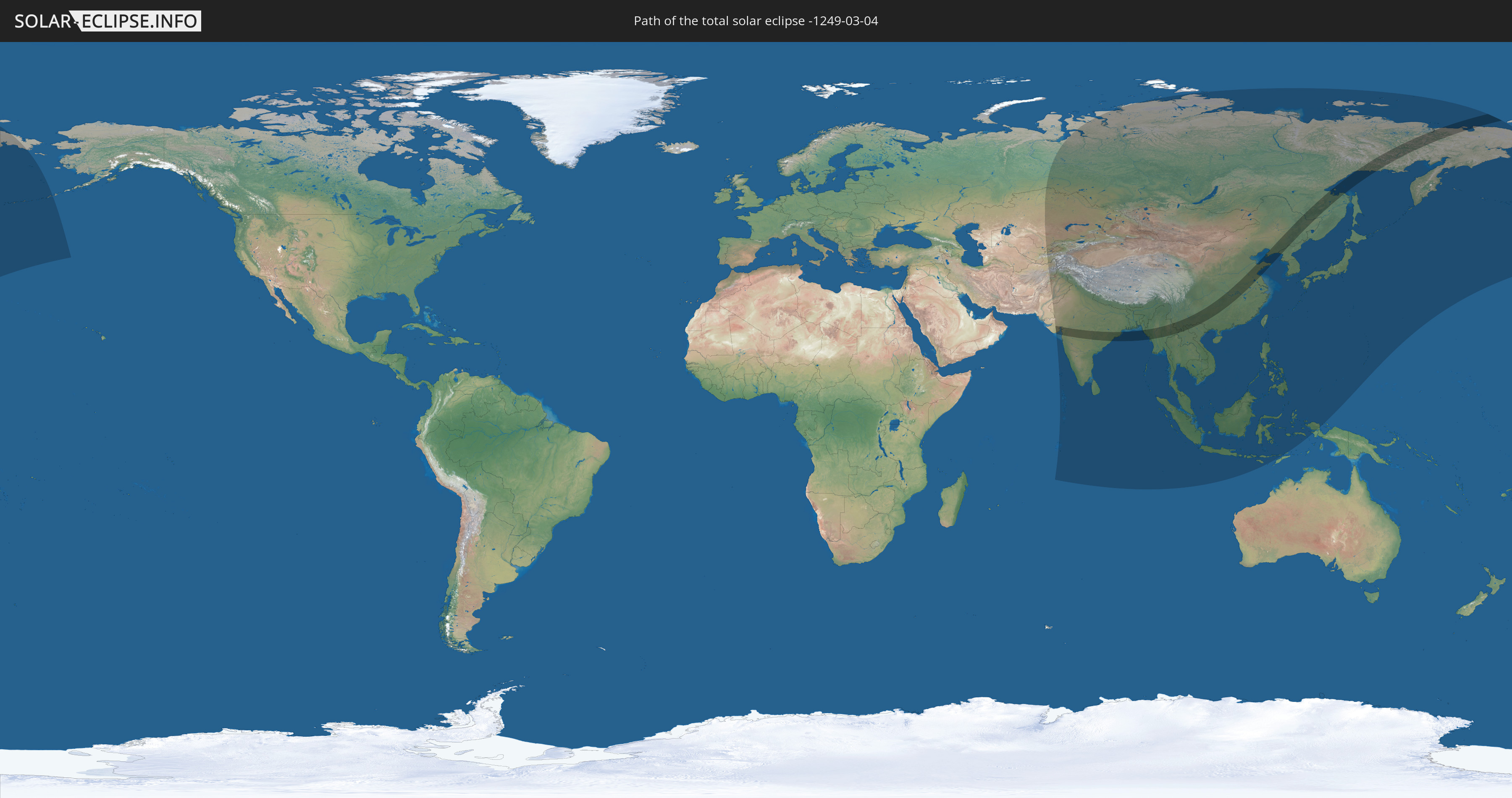
Die Sonnenfinsternis am 03/04/-1249 kann man in 40 Ländern als partielle Sonnenfinsternis beobachten.
Der Finsternispfad verläuft durch 8 Länder. Nur in diesen Ländern ist sie als total Sonnenfinsternis zu sehen.
In den folgenden Ländern ist die Sonnenfinsternis total zu sehen
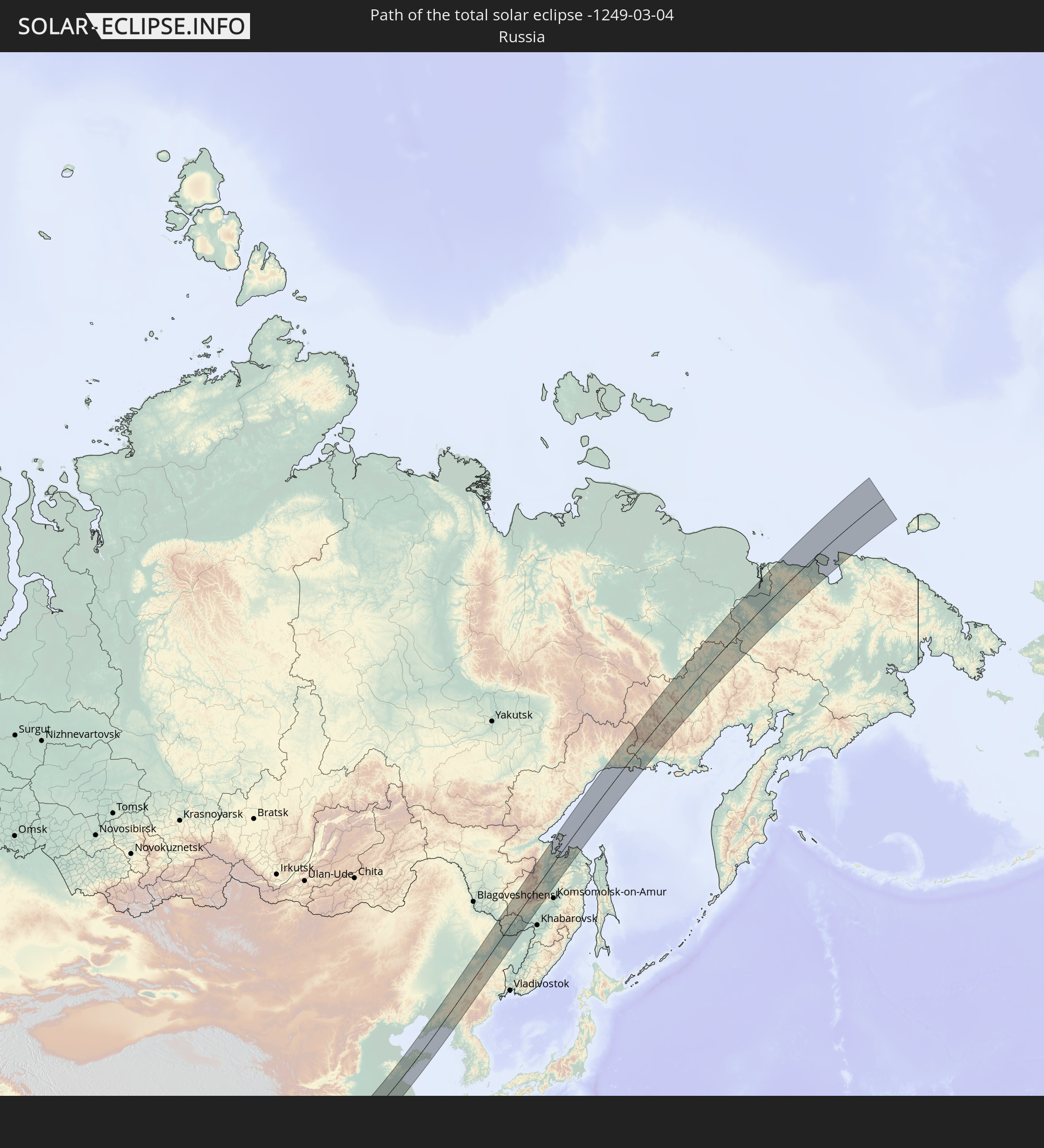 Russia
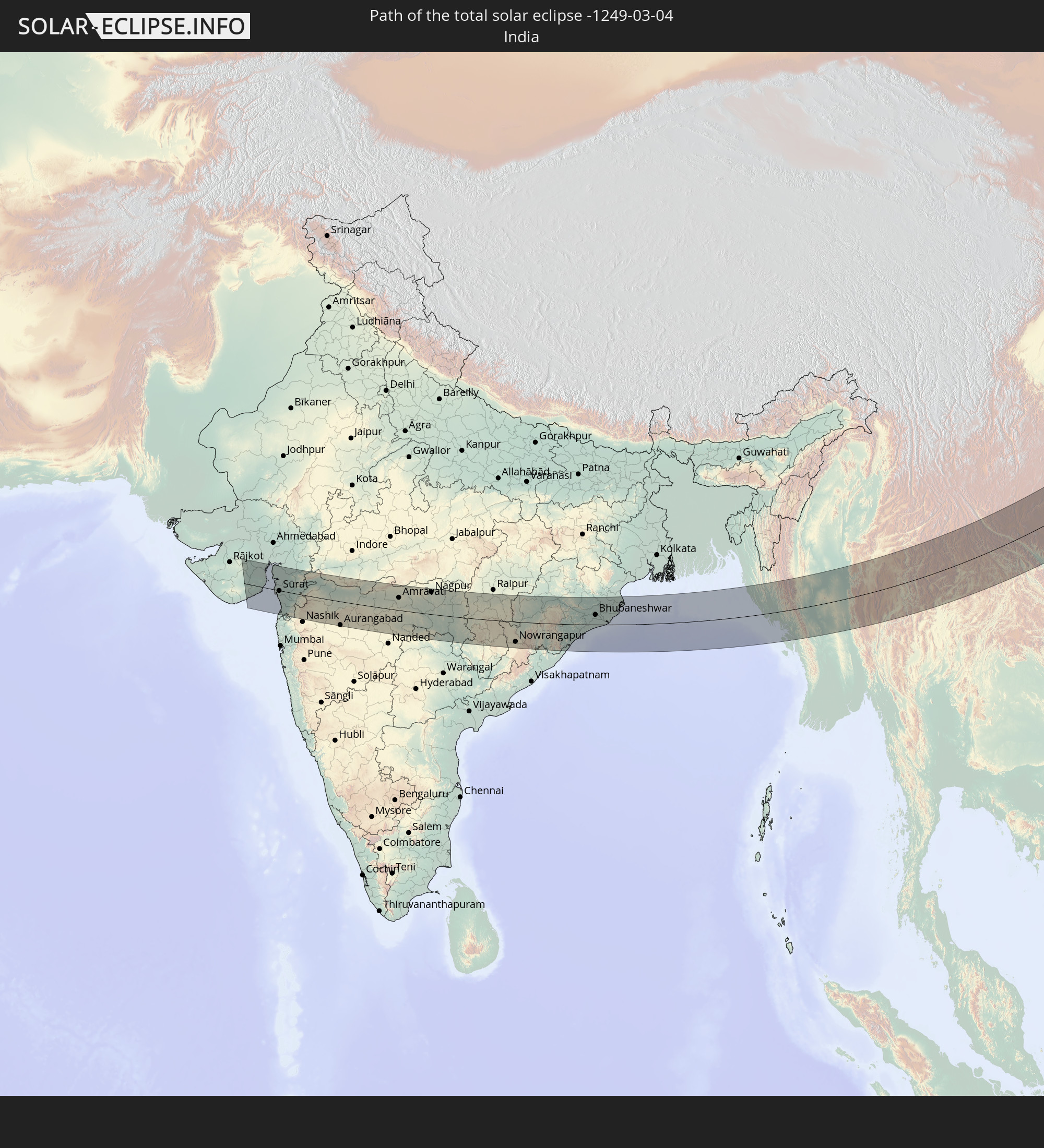 India
India
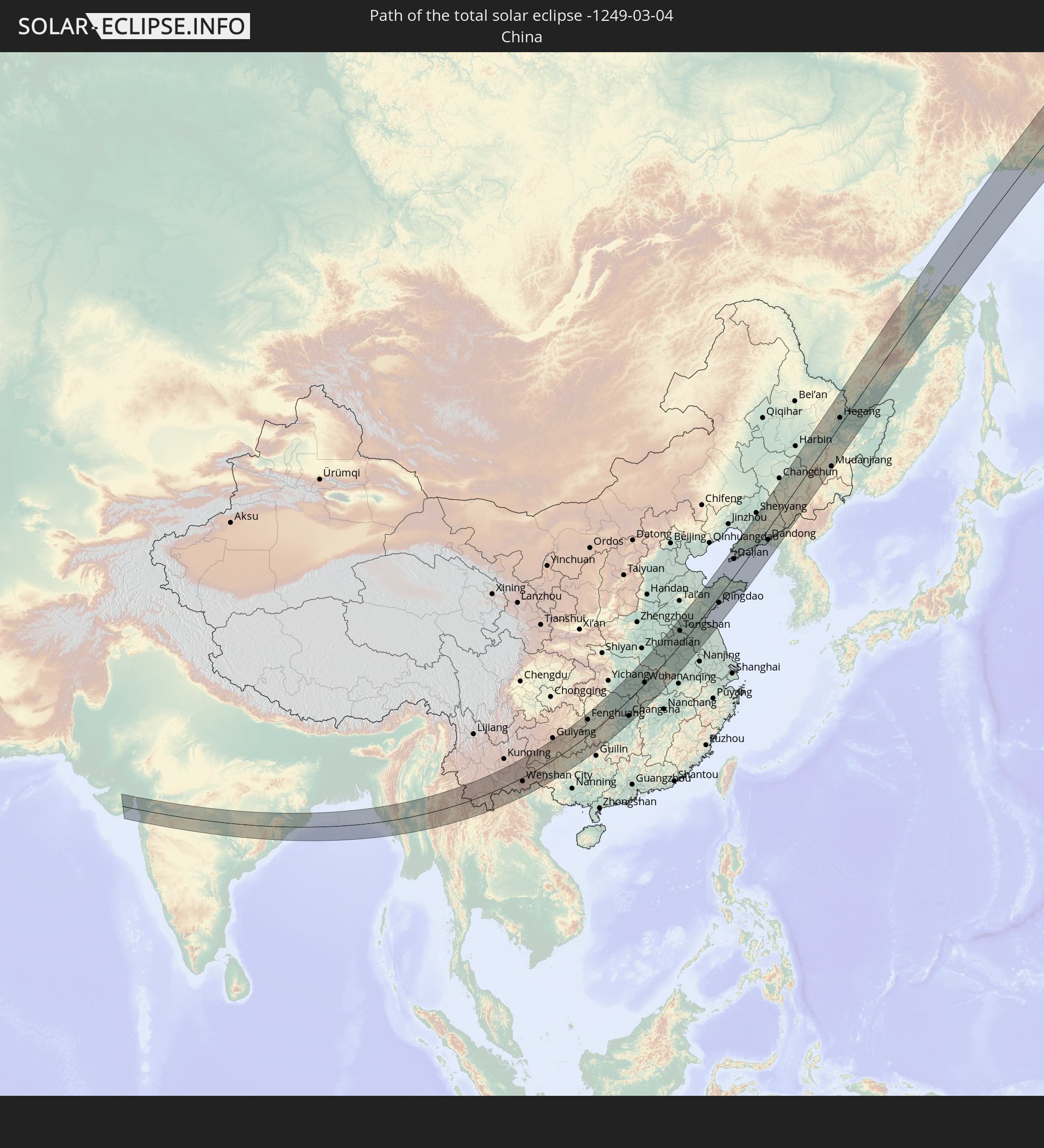 China
China
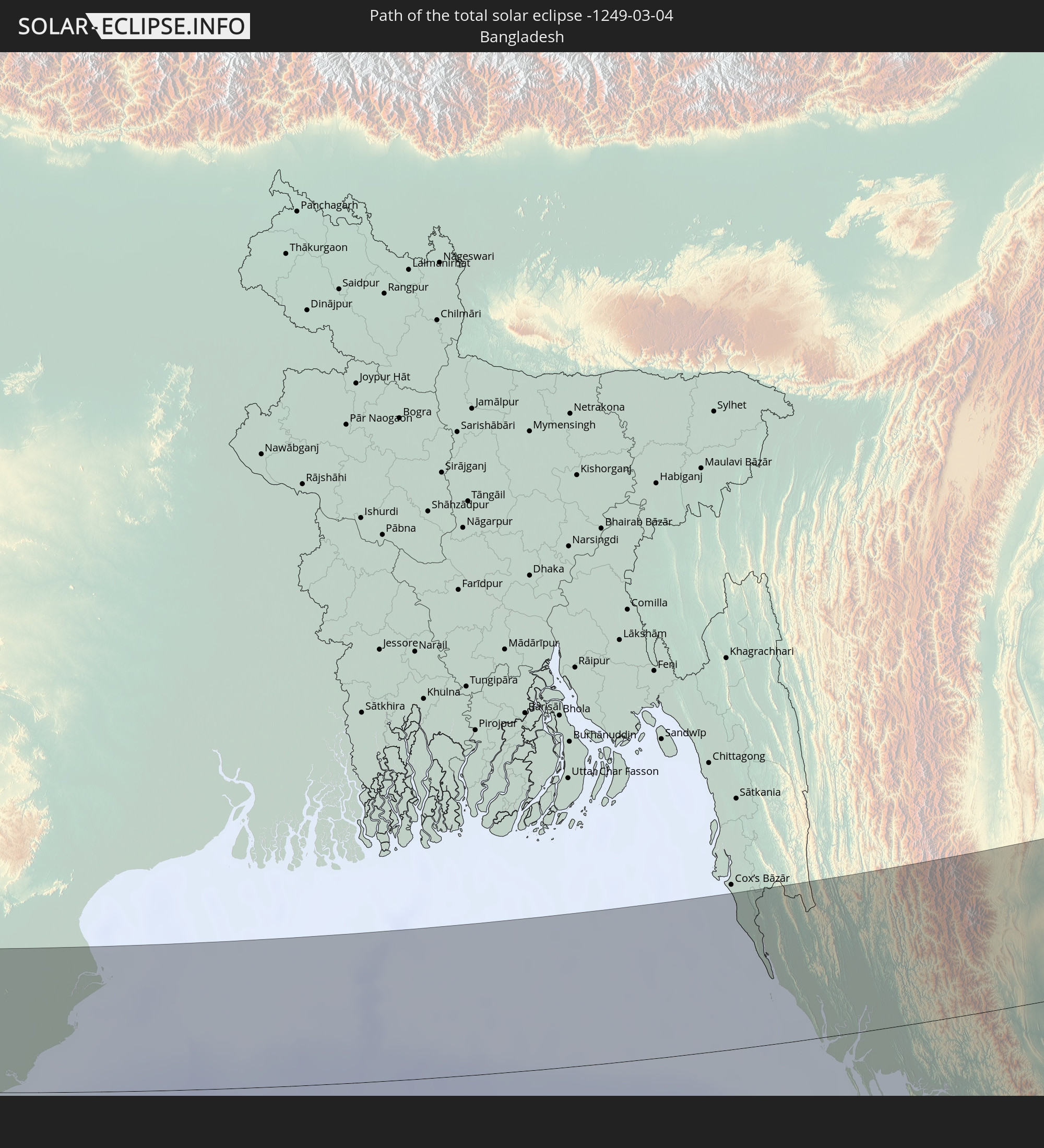 Bangladesh
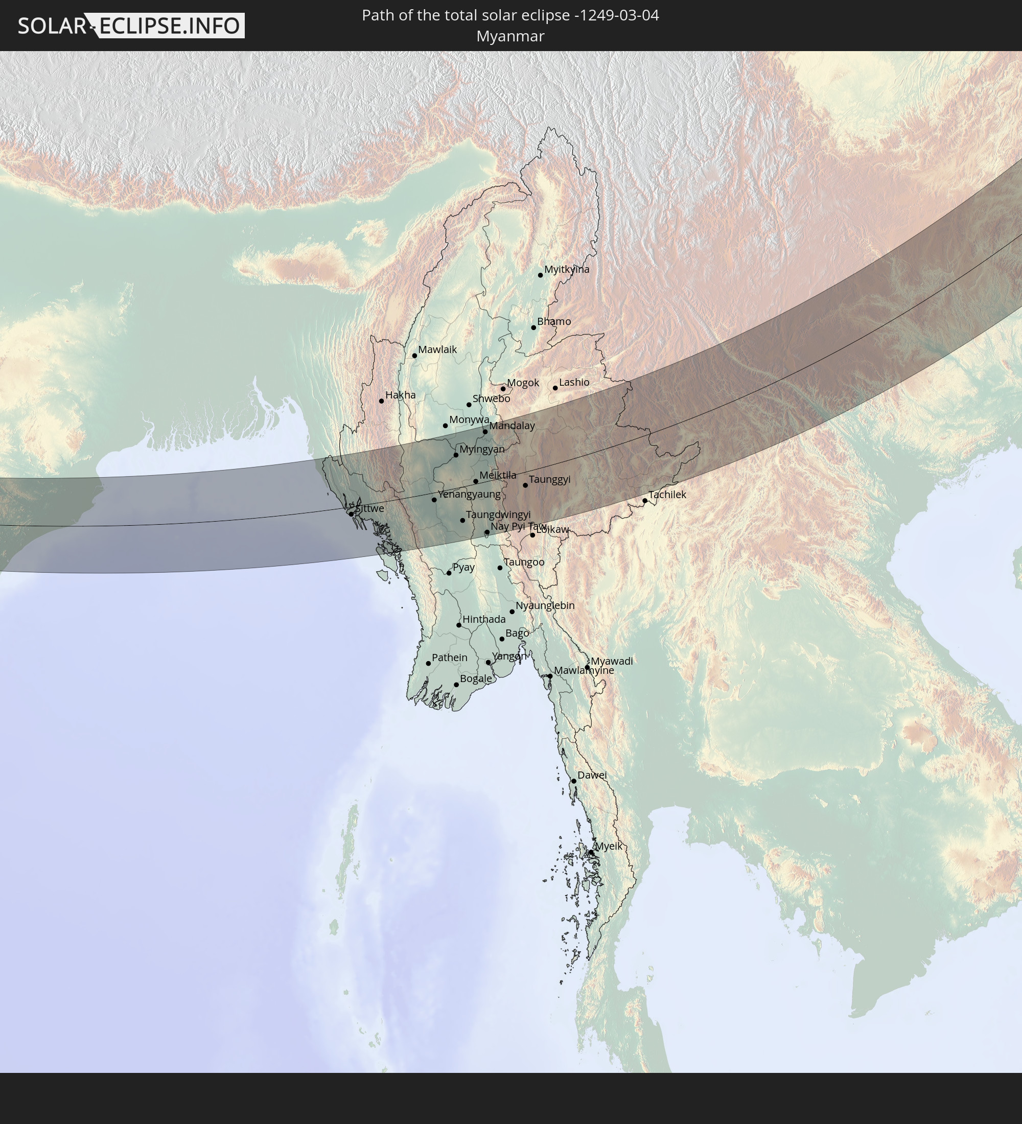 Myanmar
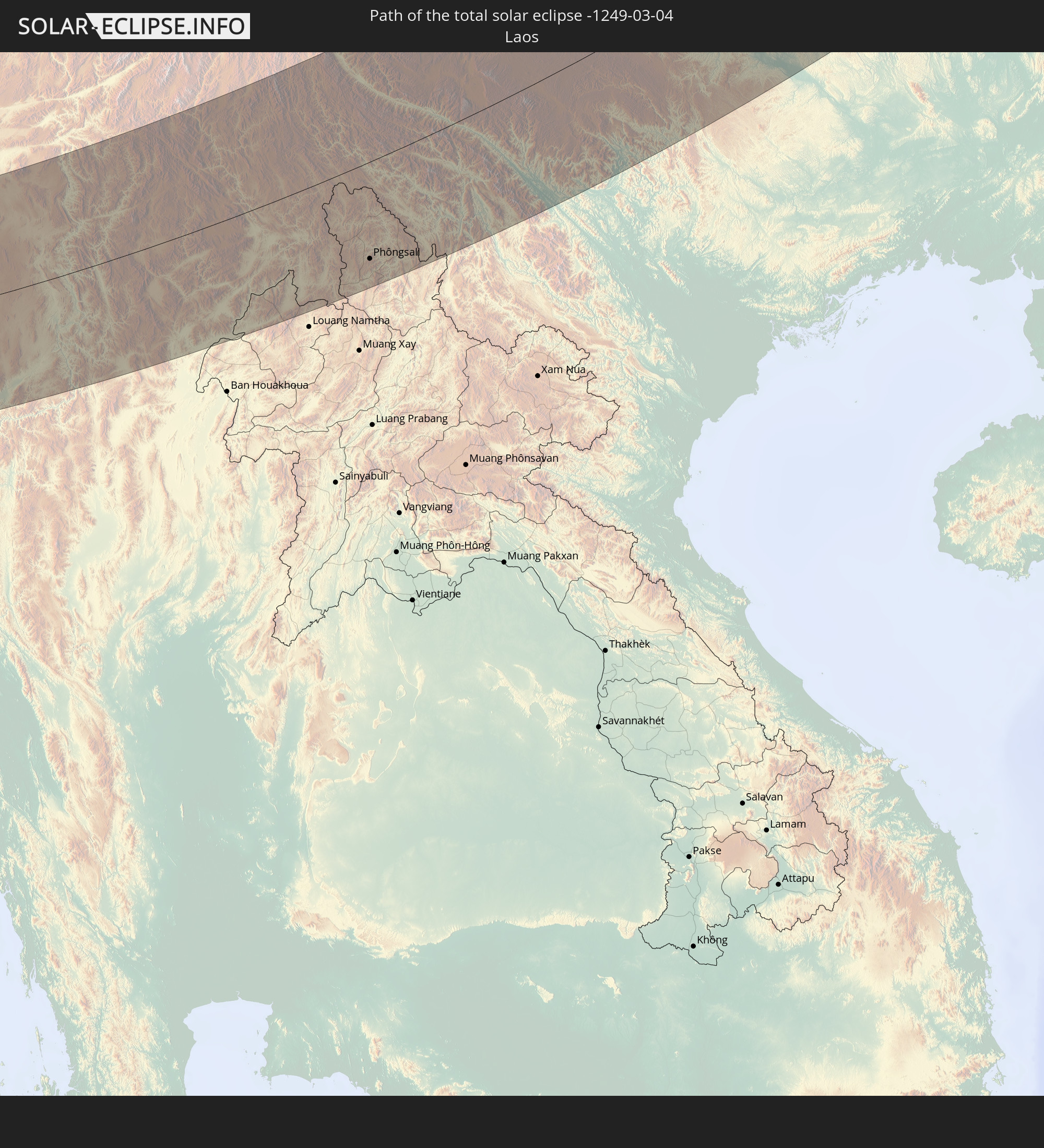 Laos
Laos
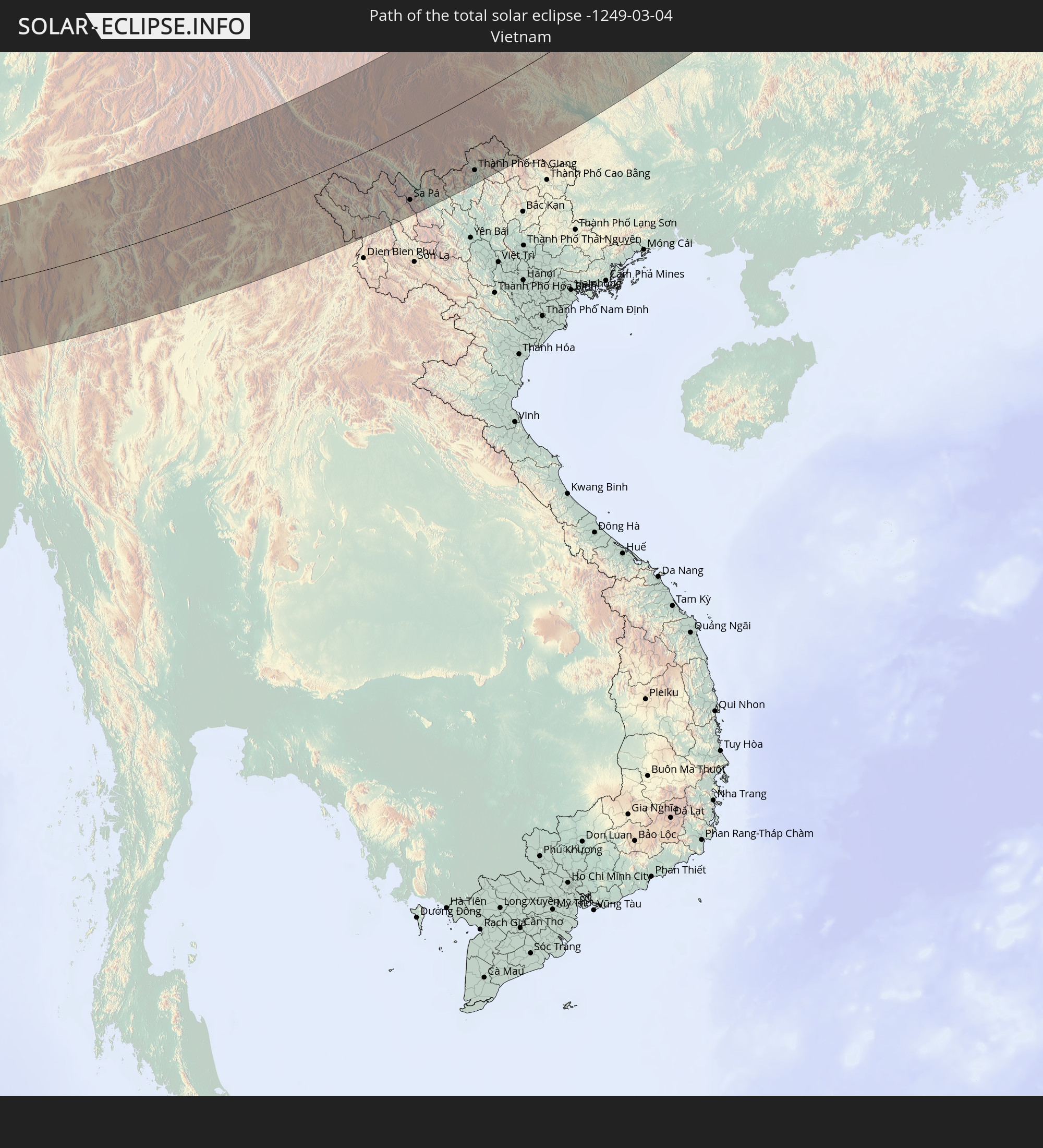 Vietnam
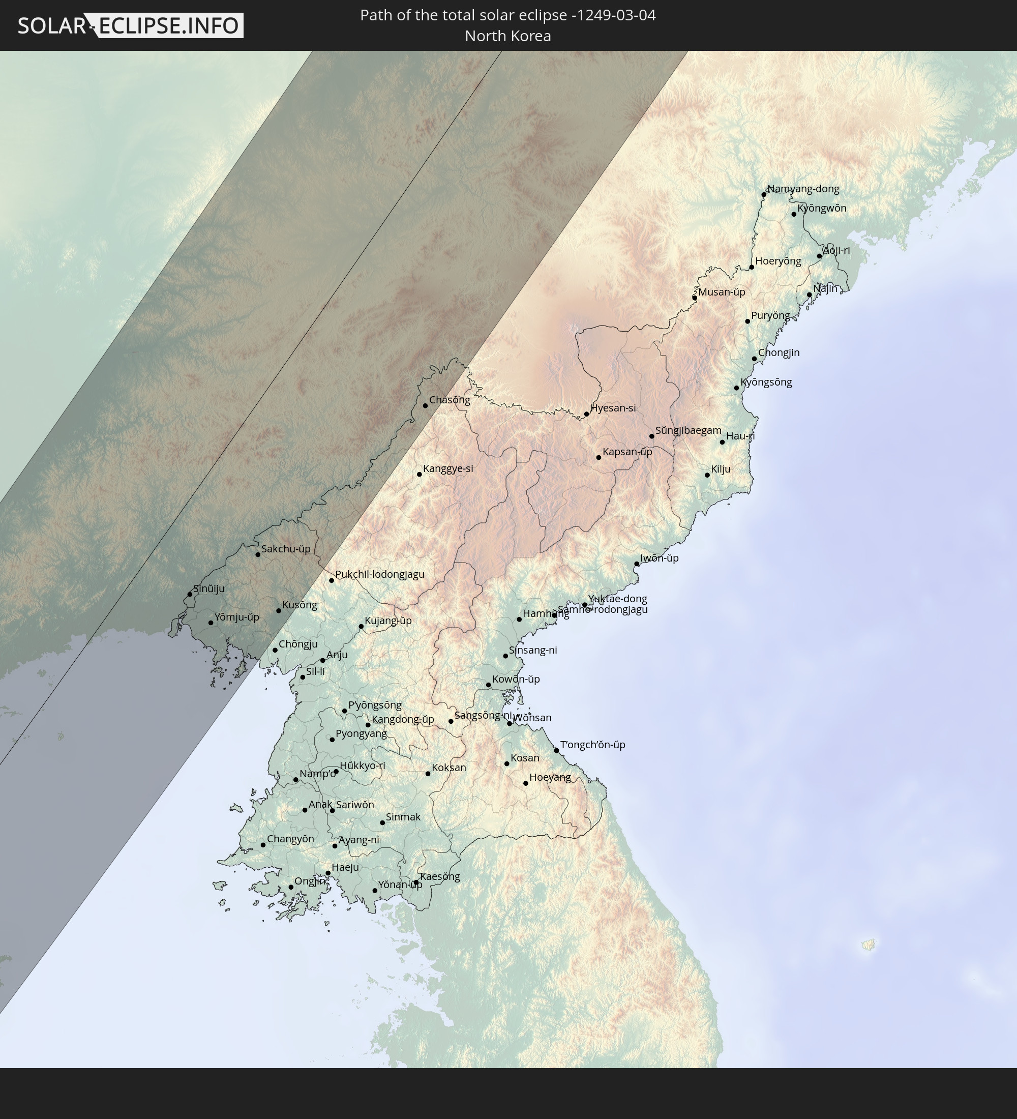 North Korea
In den folgenden Ländern ist die Sonnenfinsternis partiell zu sehen
 Russia
 United States
 Kazakhstan
 Uzbekistan
 Afghanistan
 Pakistan
 Tajikistan
 India
India
 Kyrgyzstan
 British Indian Ocean Territory
 Maldives
 China
China
 Sri Lanka
 Nepal
Nepal
 Mongolia
 Bangladesh
 Bhutan
 Myanmar
 Indonesia
 Cocos Islands
 Thailand
 Malaysia
 Laos
Laos
 Vietnam
 Cambodia
 Singapore
 Christmas Island
 Macau
Macau
 Hong Kong
 Brunei
 Taiwan
 Philippines
 Japan
Japan
 East Timor
 North Korea
 South Korea
 Palau
Palau
 Federated States of Micronesia
 Guam
Guam
 Northern Mariana Islands
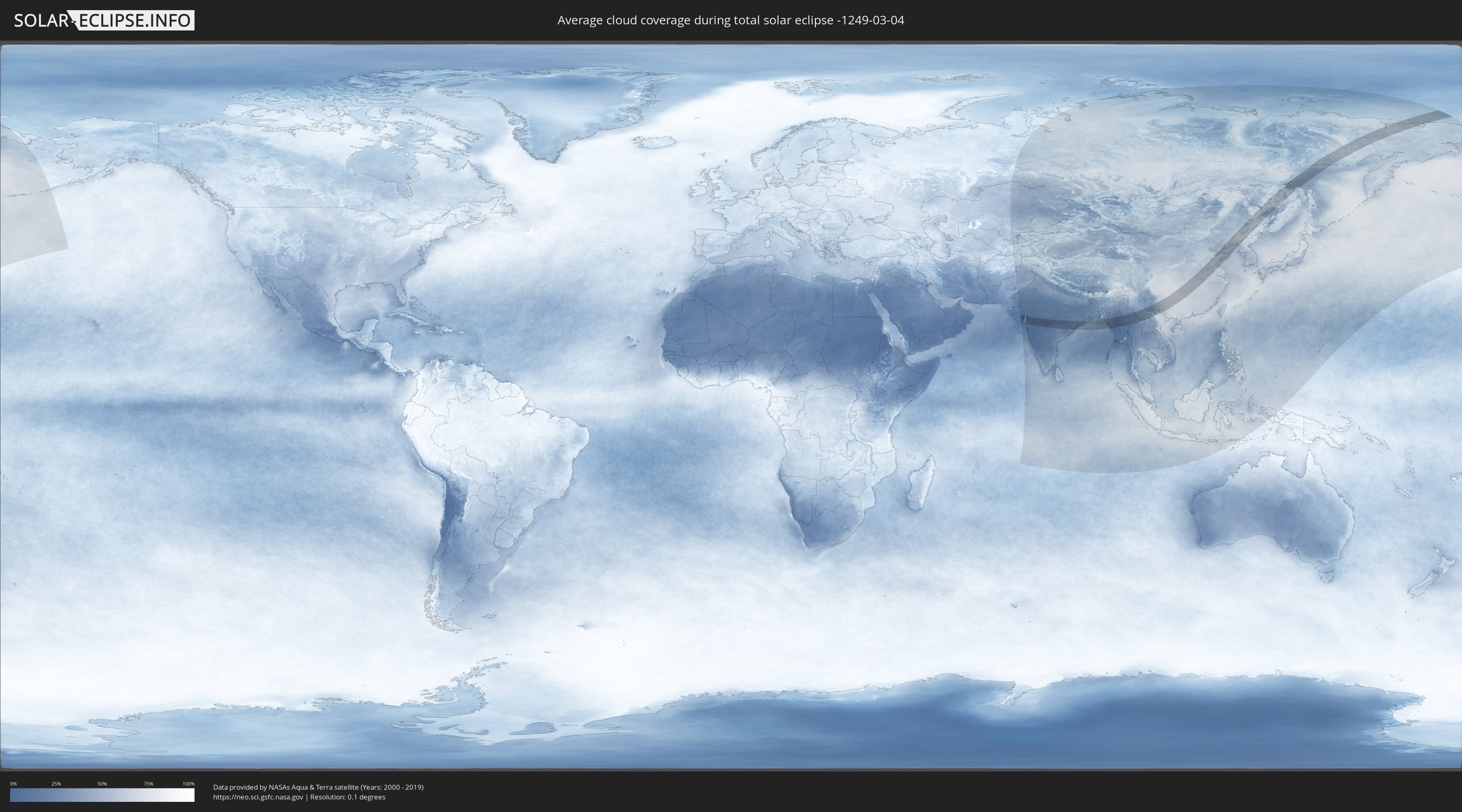
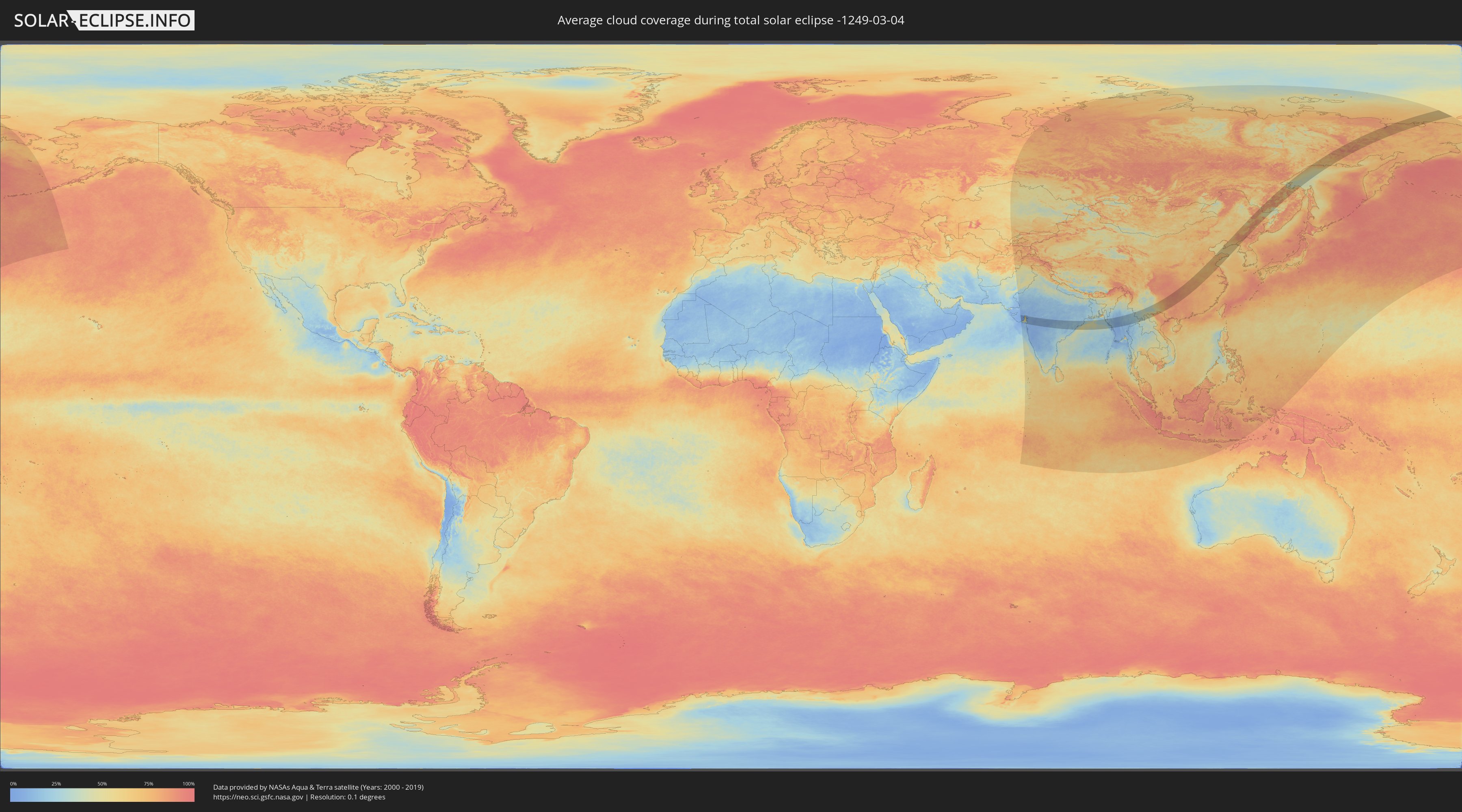
How will be the weather during the total solar eclipse on 03/04/-1249?
Where is the best place to see the total solar eclipse of 03/04/-1249?
The following maps show the average cloud coverage for the day of the total solar eclipse.
With the help of these maps, it is possible to find the place along the eclipse path, which has the best
chance of a cloudless sky.
Nevertheless, you should consider local circumstances and inform about the weather of your chosen
observation site.
The data is provided by NASAs satellites
AQUA and TERRA.
The cloud maps are averaged over a period of 19 years (2000 - 2019).
Detailed country maps
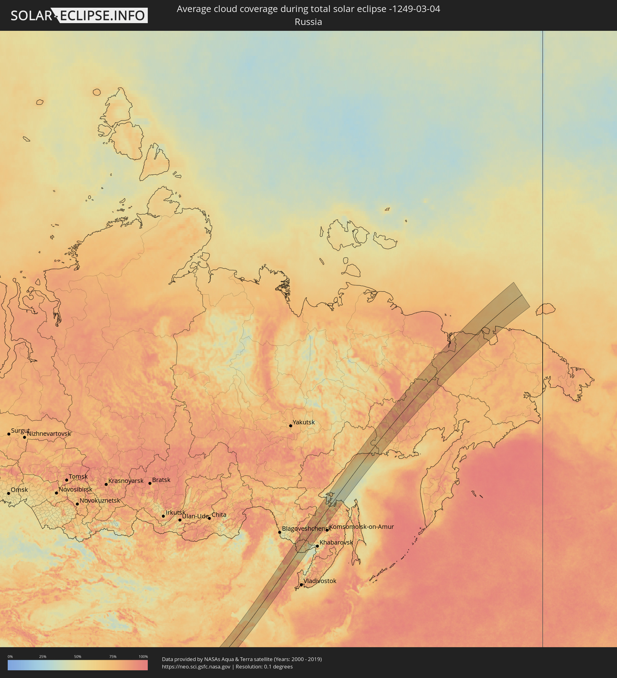 Russia
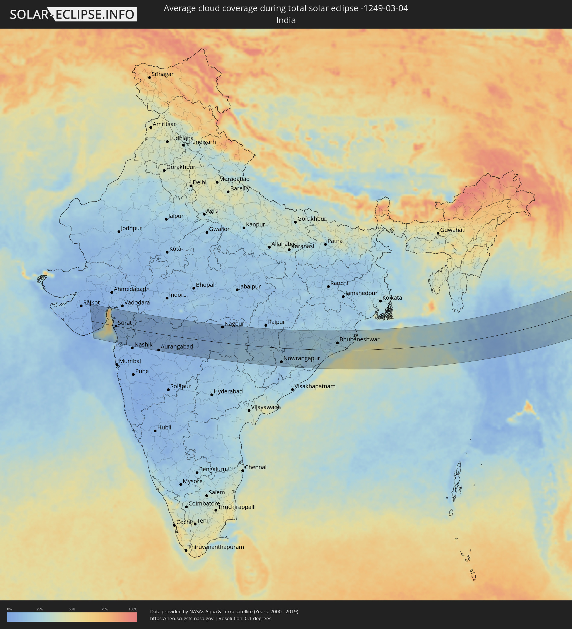 India
India
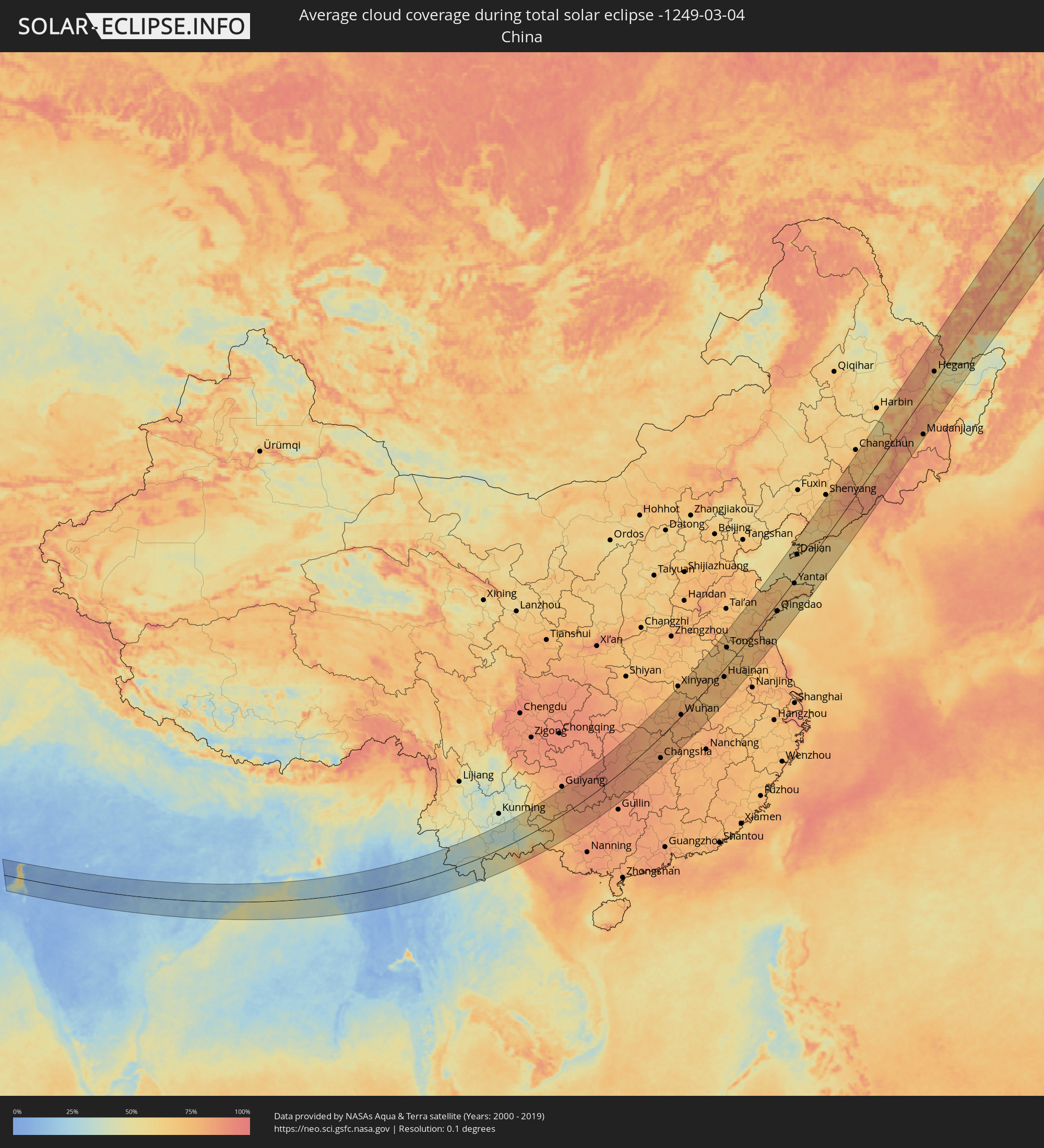 China
China
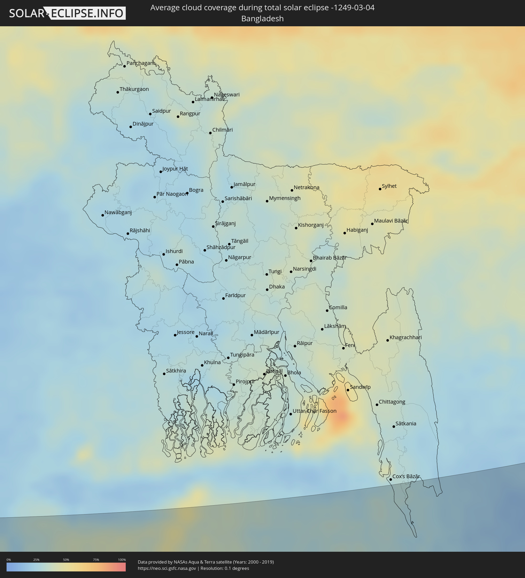 Bangladesh
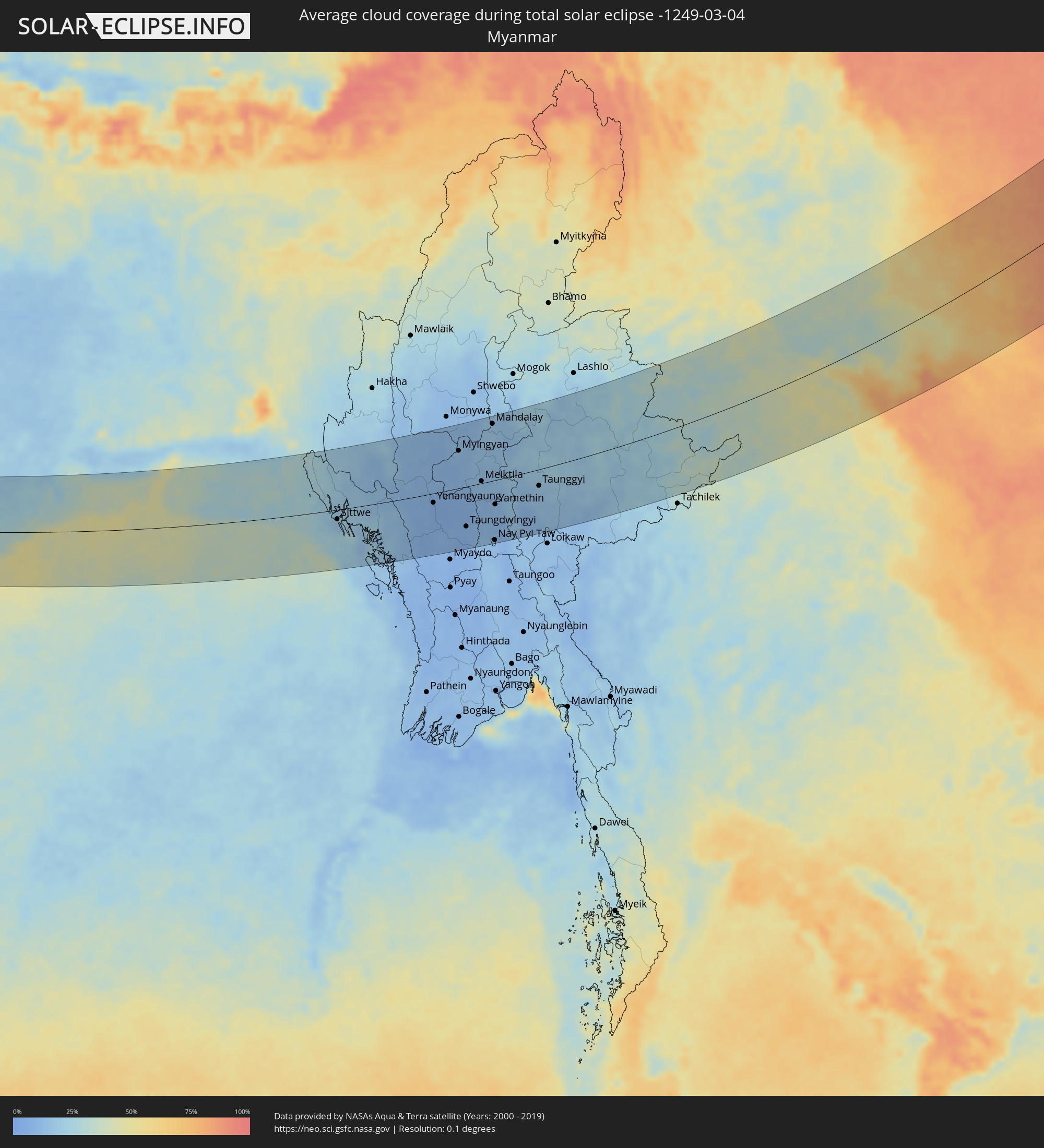 Myanmar
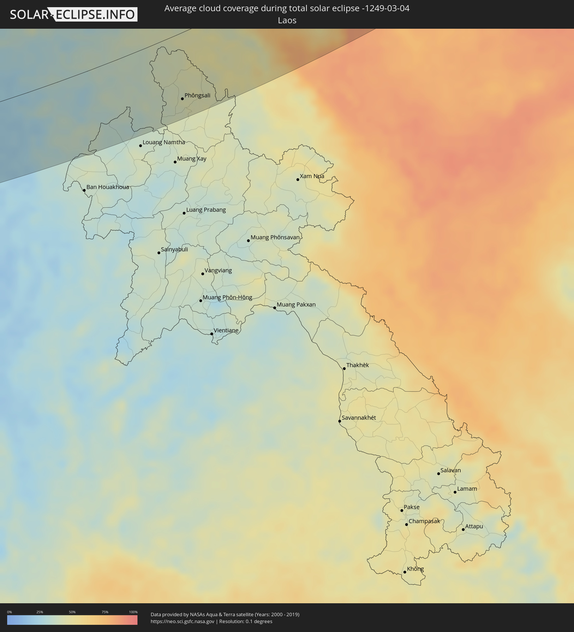 Laos
Laos
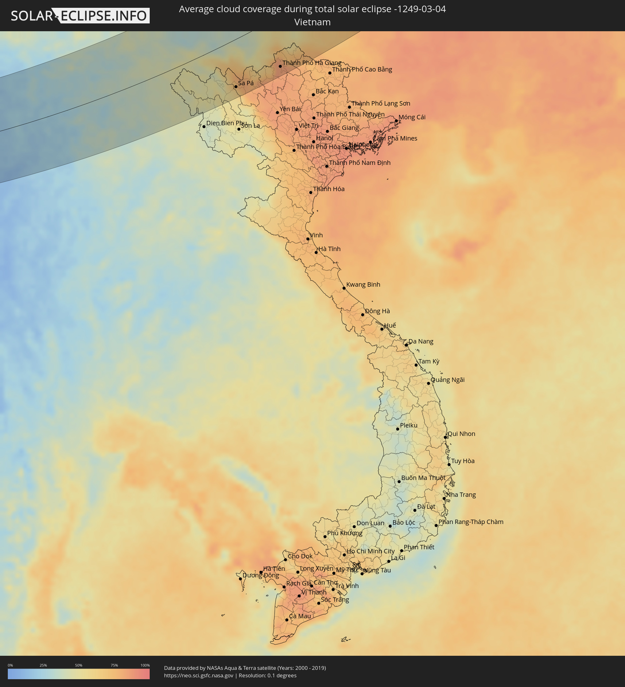 Vietnam
 North Korea
Cities inside the path of the eclipse
The following table shows all locations with a population of more than 5,000 inside the eclipse path. Cities which have more than 100,000 inhabitants are marked bold. A click at the locations opens a detailed map.
| City | Type | Eclipse duration | Local time of max. eclipse | Distance to central line | Ø Cloud coverage |
|
Botād, Gujarat
|
total | - | 07:11:33 UTC+05:21 | 81 km | 3% |
|
Bhāvnagar, Gujarat
|
total | - | 07:11:09 UTC+05:21 | 48 km | 13% |
|
Sūrat, Gujarat
|
total | - | 07:10:35 UTC+05:21 | 2 km | 7% |
|
Bilimora, Gujarat
|
total | - | 07:10:03 UTC+05:21 | 46 km | 9% |
|
Bharūch, Gujarat
|
total | - | 07:11:18 UTC+05:21 | 56 km | 6% |
|
Mālegaon, Maharashtra
|
total | - | 07:10:17 UTC+05:21 | 40 km | 6% |
|
Dhūlia, Maharashtra
|
total | - | 07:10:51 UTC+05:21 | 3 km | 5% |
|
Aurangabad, Maharashtra
|
total | - | 07:09:40 UTC+05:21 | 100 km | 8% |
|
Jalgaon, Maharashtra
|
total | - | 07:11:18 UTC+05:21 | 27 km | 8% |
|
Bhusāval, Maharashtra
|
total | - | 07:11:26 UTC+05:21 | 35 km | 8% |
|
Jālna, Maharashtra
|
total | - | 07:09:50 UTC+05:21 | 95 km | 8% |
|
Burhānpur, Madhya Pradesh
|
total | - | 07:12:00 UTC+05:21 | 72 km | 10% |
|
Akola, Maharashtra
|
total | - | 07:11:30 UTC+05:21 | 18 km | 8% |
|
Amrāvati, Maharashtra
|
total | - | 07:12:10 UTC+05:21 | 53 km | 8% |
|
Yavatmāl, Maharashtra
|
total | - | 07:11:36 UTC+05:21 | 2 km | 9% |
|
Ādilābād, Telangana
|
total | - | 07:10:48 UTC+05:21 | 76 km | 12% |
|
Wardha, Maharashtra
|
total | - | 07:12:19 UTC+05:21 | 43 km | 10% |
|
Nagpur, Maharashtra
|
total | - | 07:13:09 UTC+05:21 | 94 km | 9% |
|
Chānda, Maharashtra
|
total | - | 07:11:34 UTC+05:21 | 36 km | 13% |
|
Rāj-Nāndgaon, Chhattisgarh
|
total | - | 07:14:12 UTC+05:21 | 109 km | 14% |
|
Nowrangapur, Odisha
|
total | - | 07:12:28 UTC+05:21 | 86 km | 17% |
|
Brahmapur, Odisha
|
total | - | 07:14:09 UTC+05:21 | 67 km | 23% |
|
Puri, Odisha
|
total | - | 07:15:39 UTC+05:21 | 11 km | 32% |
|
Bhubaneshwar, Odisha
|
total | - | 07:16:22 UTC+05:21 | 42 km | 25% |
|
Cuttack, Odisha
|
total | - | 07:16:42 UTC+05:21 | 63 km | 22% |
|
Teknāf, Chittagong
|
total | - | 07:55:30 UTC+05:53 | 67 km | 25% |
|
Sittwe, Rakhine
|
total | - | 08:26:27 UTC+06:24 | 20 km | 15% |
|
Chauk, Magway
|
total | - | 08:29:51 UTC+06:24 | 29 km | 11% |
|
Yenangyaung, Magway
|
total | - | 08:29:12 UTC+06:24 | 19 km | 6% |
|
Minbu, Magway
|
total | - | 08:28:45 UTC+06:24 | 51 km | 7% |
|
Magway, Magway
|
total | - | 08:28:46 UTC+06:24 | 55 km | 7% |
|
Pakokku, Magway
|
total | - | 08:30:53 UTC+06:24 | 71 km | 9% |
|
Myingyan, Mandalay
|
total | - | 08:31:27 UTC+06:24 | 78 km | 12% |
|
Taungdwingyi, Magway
|
total | - | 08:29:16 UTC+06:24 | 83 km | 9% |
|
Meiktila, Mandalay
|
total | - | 08:31:04 UTC+06:24 | 4 km | 12% |
|
Sagaing, Sagain
|
total | - | 08:32:53 UTC+06:24 | 110 km | 16% |
|
Mandalay, Mandalay
|
total | - | 08:33:10 UTC+06:24 | 118 km | 16% |
|
Nay Pyi Taw, Nay Pyi Taw
|
total | - | 08:29:33 UTC+06:24 | 125 km | 11% |
|
Kyaukse, Mandalay
|
total | - | 08:32:37 UTC+06:24 | 77 km | 13% |
|
Yamethin, Mandalay
|
total | - | 08:30:41 UTC+06:24 | 50 km | 11% |
|
Pyinmana, Nay Pyi Taw
|
total | - | 08:29:38 UTC+06:24 | 127 km | 9% |
|
Pyin Oo Lwin, Mandalay
|
total | - | 08:33:44 UTC+06:24 | 115 km | 16% |
|
Taunggyi, Shan
|
total | - | 08:32:23 UTC+06:24 | 34 km | 16% |
|
Phôngsali, Phôngsali
|
total | - | 08:58:07 UTC+06:42 | 106 km | 41% |
|
Lai Châu, Lai Châu
|
total | - | 09:25:59 UTC+07:06 | 91 km | 46% |
|
Sa Pá, Lào Cai
|
total | - | 09:26:28 UTC+07:06 | 113 km | 59% |
|
Lào Cai, Lào Cai
|
total | - | 09:26:55 UTC+07:06 | 105 km | 79% |
|
Thành Phố Hà Giang, Hà Giang
|
total | - | 09:29:05 UTC+07:06 | 118 km | 83% |
|
Xiangtan, Hunan
|
total | - | 10:44:29 UTC+08:00 | 121 km | 82% |
|
Changsha, Hunan
|
total | - | 10:45:13 UTC+08:00 | 97 km | 83% |
|
Yueyang, Hunan
|
total | - | 10:47:28 UTC+08:00 | 10 km | 80% |
|
Wuhan, Hubei
|
total | - | 10:51:33 UTC+08:00 | 5 km | 81% |
|
Huangshi, Hubei
|
total | - | 10:52:20 UTC+08:00 | 75 km | 79% |
|
Huaibei, Anhui
|
total | - | 11:01:26 UTC+08:00 | 80 km | 76% |
|
Huainan, Anhui
|
total | - | 10:59:38 UTC+08:00 | 32 km | 75% |
|
Tongshan, Jiangsu
|
total | - | 11:02:22 UTC+08:00 | 68 km | 71% |
|
Hefei, Anhui
|
total | - | 10:58:53 UTC+08:00 | 108 km | 81% |
|
Bengbu, Anhui
|
total | - | 11:00:45 UTC+08:00 | 35 km | 76% |
|
Huai'an, Jiangsu
|
total | - | 11:04:36 UTC+08:00 | 106 km | 79% |
|
Zhu Cheng City, Shandong
|
total | - | 11:08:53 UTC+08:00 | 34 km | 74% |
|
Qingdao, Shandong
|
total | - | 11:10:35 UTC+08:00 | 30 km | 66% |
|
Yantai, Shandong
|
total | - | 11:14:20 UTC+08:00 | 11 km | 70% |
|
Dalian, Liaoning
|
total | - | 11:16:33 UTC+08:00 | 73 km | 62% |
|
Anshan, Liaoning
|
total | - | 11:21:31 UTC+08:00 | 117 km | 72% |
|
Liaoyang, Liaoning
|
total | - | 11:21:59 UTC+08:00 | 114 km | 72% |
|
Benxi, Liaoning
|
total | - | 11:22:54 UTC+08:00 | 75 km | 75% |
|
Fushun, Liaoning
|
total | - | 11:23:48 UTC+08:00 | 100 km | 71% |
|
Dandong, Liaoning
|
total | - | 11:22:28 UTC+08:00 | 43 km | 68% |
|
Sinŭiju, P'yŏngan-bukto
|
total | - | 11:45:27 UTC+08:23 | 45 km | 68% |
|
Ŭiju, P'yŏngan-bukto
|
total | - | 11:45:46 UTC+08:23 | 48 km | 71% |
|
Yŏmju-ŭp, P'yŏngan-bukto
|
total | - | 11:45:30 UTC+08:23 | 73 km | 69% |
|
Sakchu-ŭp, P'yŏngan-bukto
|
total | - | 11:46:47 UTC+08:23 | 71 km | 76% |
|
Kwaksan, P'yŏngan-bukto
|
total | - | 11:46:00 UTC+08:23 | 120 km | 71% |
|
Panghyŏn-dong, P'yŏngan-bukto
|
total | - | 11:46:29 UTC+08:23 | 118 km | 73% |
|
Kusŏng, P'yŏngan-bukto
|
total | - | 11:46:36 UTC+08:23 | 112 km | 73% |
|
Jilin, Jilin
|
total | - | 11:29:52 UTC+08:00 | 47 km | 79% |
|
Chasŏng, Chagang-do
|
total | - | 11:50:26 UTC+08:23 | 111 km | 85% |
|
Mudanjiang, Heilongjiang
|
total | - | 11:34:52 UTC+08:00 | 106 km | 75% |
|
Hegang, Heilongjiang
|
total | - | 11:38:08 UTC+08:00 | 25 km | 76% |
|
Jiamusi, Heilongjiang
|
total | - | 11:37:43 UTC+08:00 | 11 km | 70% |
|
Amurzet, Jewish Autonomous Oblast
|
total | - | 12:26:56 UTC+08:47 | 3 km | 52% |
|
Shuangyashan, Heilongjiang
|
total | - | 11:38:42 UTC+08:00 | 73 km | 80% |
|
Leninskoye, Jewish Autonomous Oblast
|
total | - | 12:29:04 UTC+08:47 | 81 km | 58% |
|
Birobidzhan, Jewish Autonomous Oblast
|
total | - | 12:30:01 UTC+08:47 | 44 km | 56% |
|
Chegdomyn, Khabarovsk Krai
|
total | - | 12:31:29 UTC+08:47 | 98 km | 62% |
|
Smidovich, Jewish Autonomous Oblast
|
total | - | 12:30:59 UTC+08:47 | 110 km | 41% |
|
Berëzovyy, Khabarovsk Krai
|
total | - | 12:34:50 UTC+08:47 | 20 km | 77% |
|
Okhotsk, Khabarovsk Krai
|
total | - | 12:43:46 UTC+08:47 | 96 km | 72% |