Total solar eclipse of 01/30/-1303
| Day of week: | Thursday |
| Maximum duration of eclipse: | 03m44s |
| Maximum width of eclipse path: | 294 km |
| Saros cycle: | 39 |
| Coverage: | 100% |
| Magnitude: | 1.0459 |
| Gamma: | 0.8578 |
Wo kann man die Sonnenfinsternis vom 01/30/-1303 sehen?
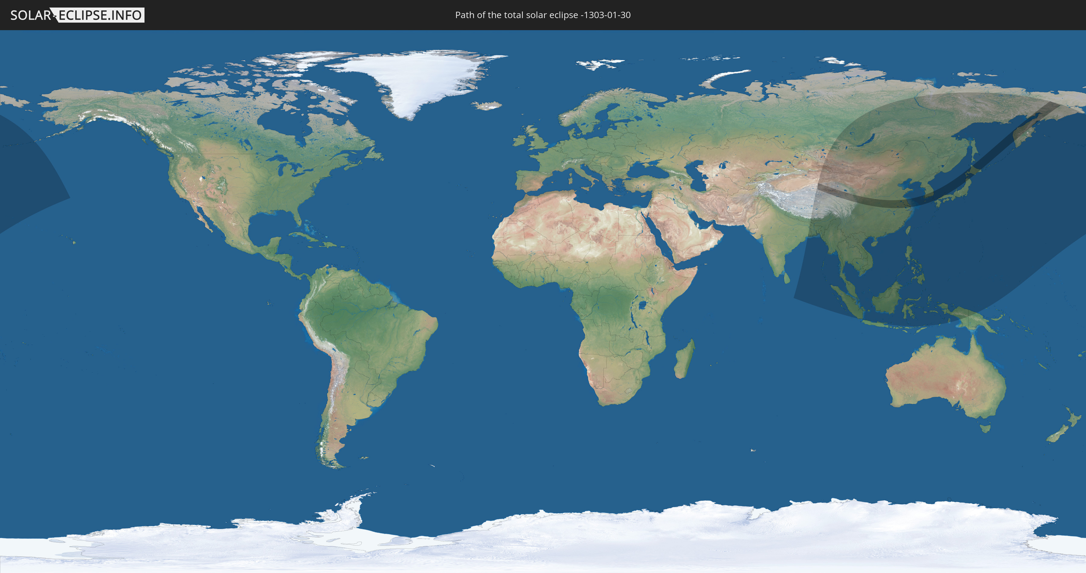
Die Sonnenfinsternis am 01/30/-1303 kann man in 30 Ländern als partielle Sonnenfinsternis beobachten.
Der Finsternispfad verläuft durch 4 Länder. Nur in diesen Ländern ist sie als total Sonnenfinsternis zu sehen.
In den folgenden Ländern ist die Sonnenfinsternis total zu sehen
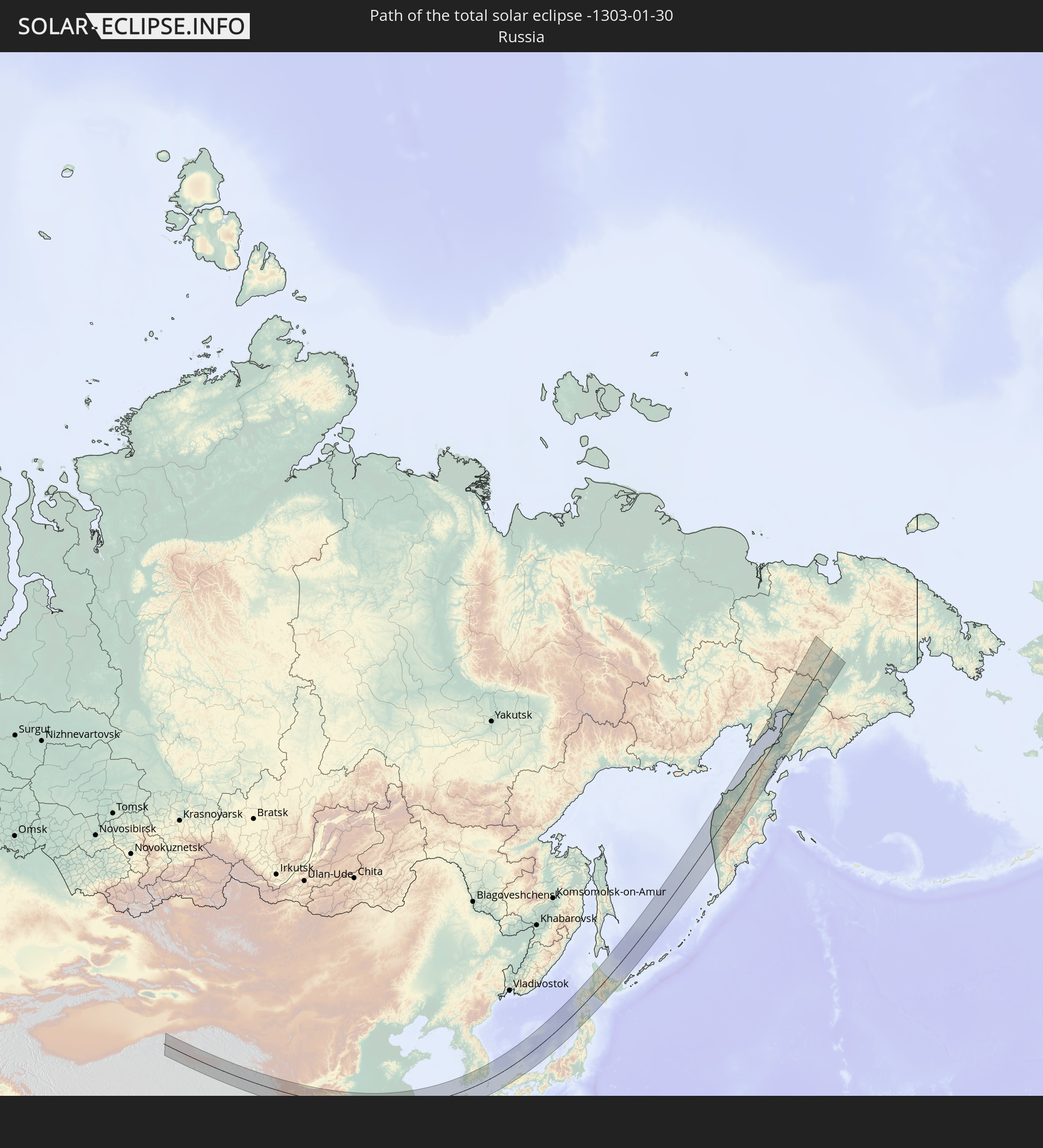 Russia
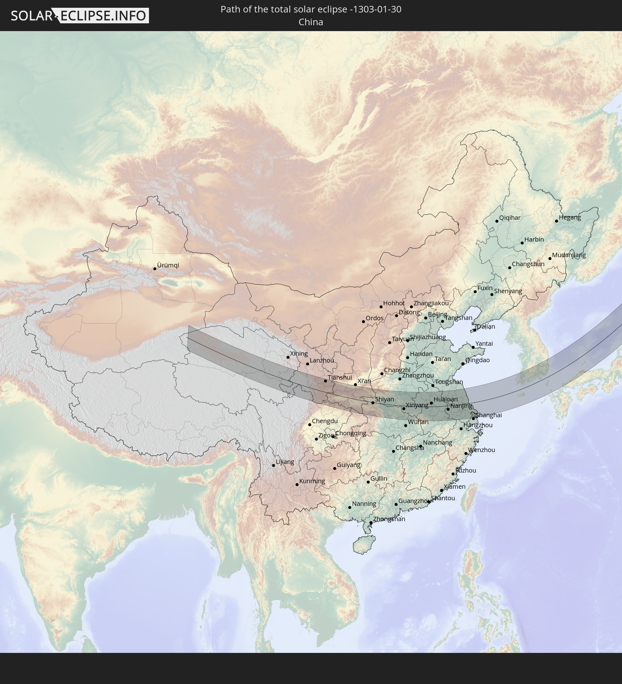 China
China
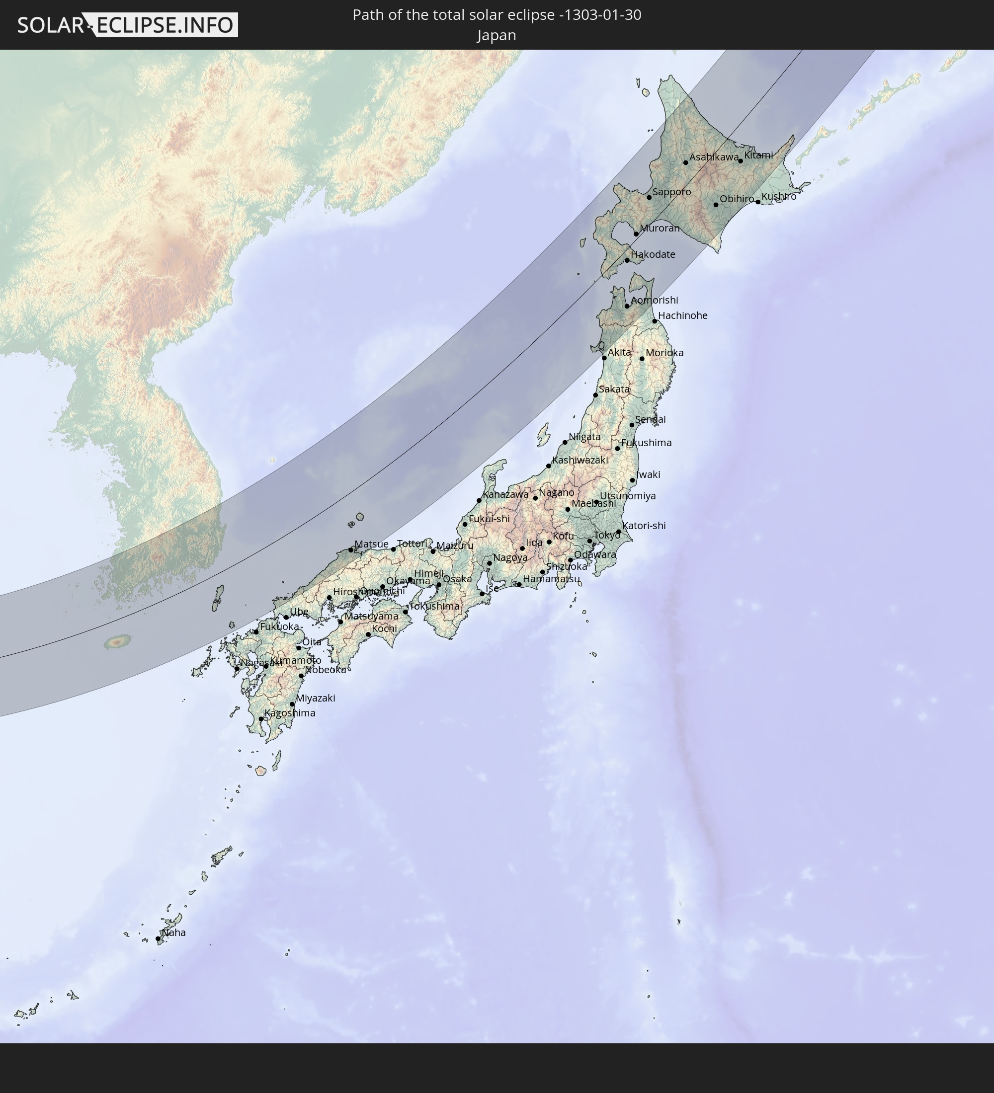 Japan
Japan
 South Korea
In den folgenden Ländern ist die Sonnenfinsternis partiell zu sehen
 Russia
 United States
 United States Minor Outlying Islands
 India
India
 China
China
 Mongolia
 Bangladesh
 Bhutan
 Myanmar
 Indonesia
 Thailand
 Malaysia
 Laos
Laos
 Vietnam
 Cambodia
 Singapore
 Macau
Macau
 Hong Kong
 Brunei
 Taiwan
 Philippines
 Japan
Japan
 North Korea
 South Korea
 Palau
Palau
 Federated States of Micronesia
 Papua New Guinea
 Guam
Guam
 Northern Mariana Islands
 Marshall Islands
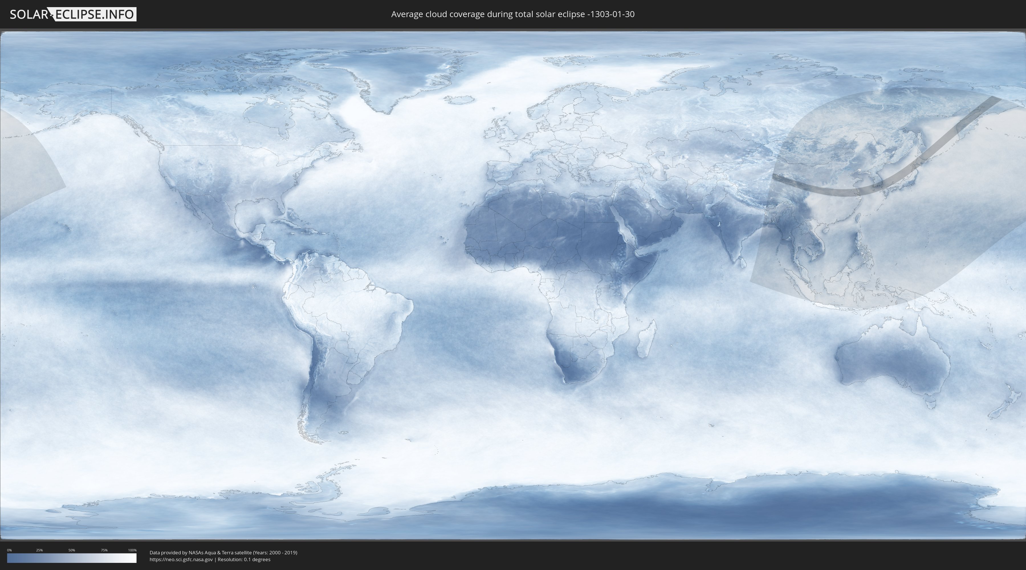
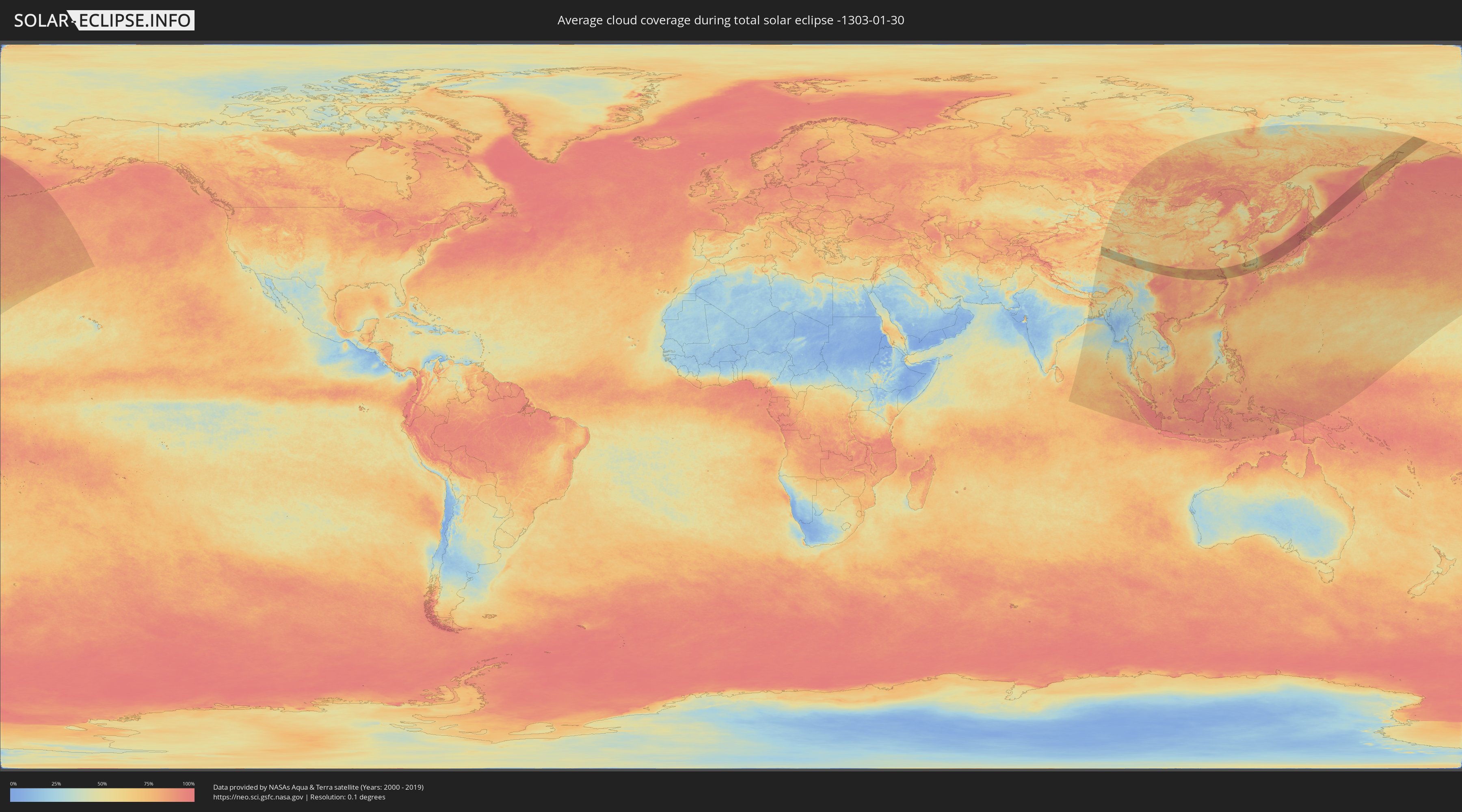
How will be the weather during the total solar eclipse on 01/30/-1303?
Where is the best place to see the total solar eclipse of 01/30/-1303?
The following maps show the average cloud coverage for the day of the total solar eclipse.
With the help of these maps, it is possible to find the place along the eclipse path, which has the best
chance of a cloudless sky.
Nevertheless, you should consider local circumstances and inform about the weather of your chosen
observation site.
The data is provided by NASAs satellites
AQUA and TERRA.
The cloud maps are averaged over a period of 19 years (2000 - 2019).
Detailed country maps
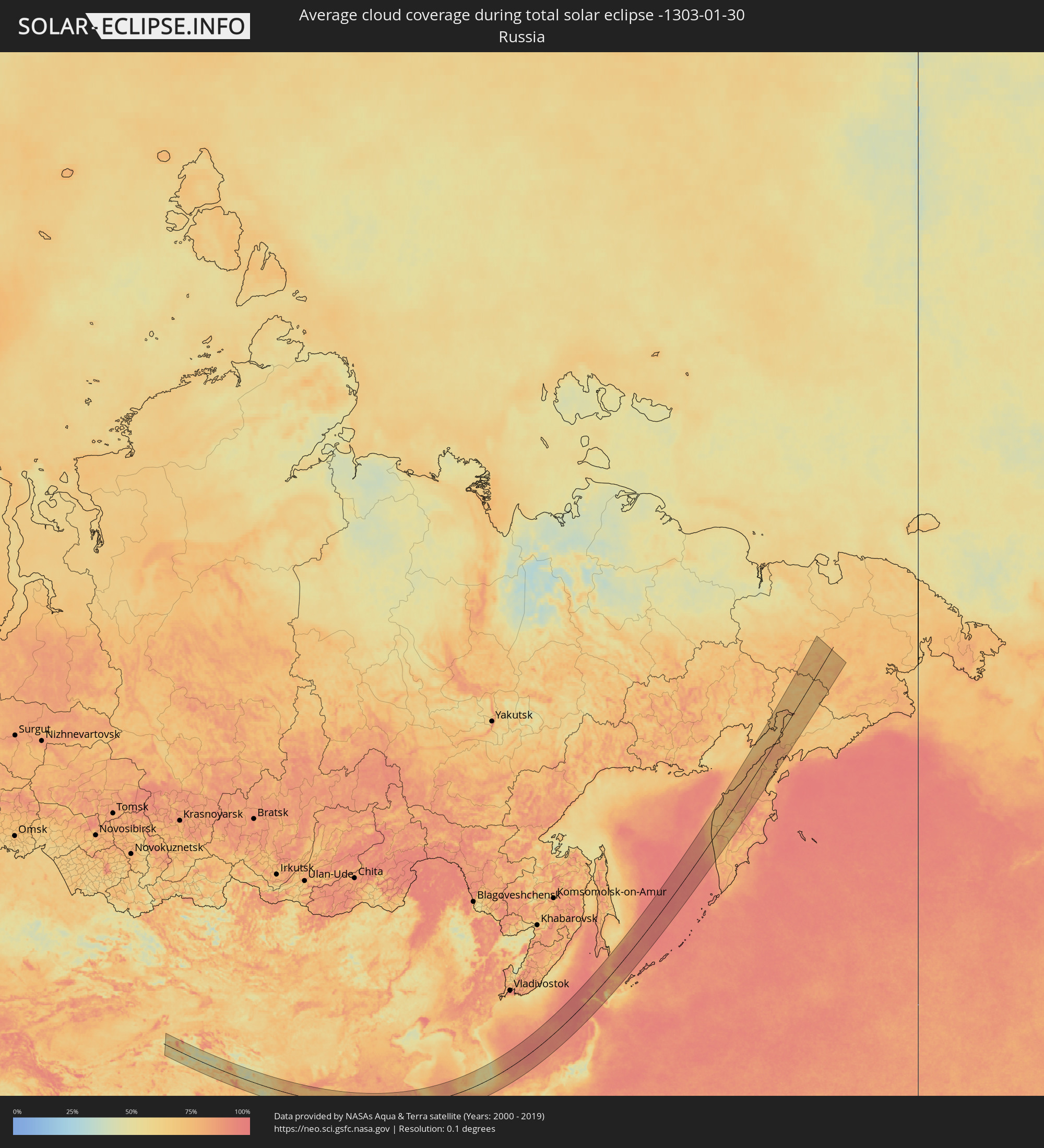 Russia
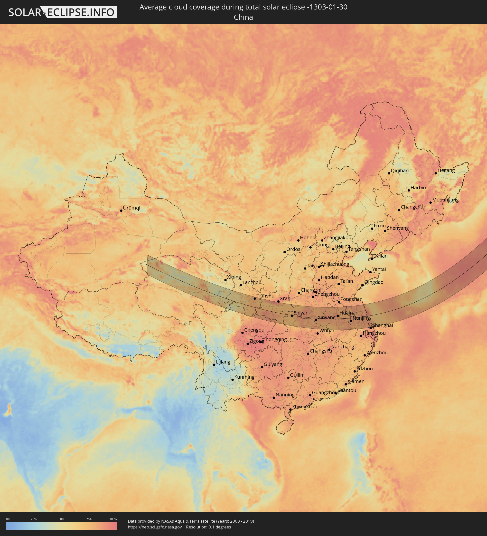 China
China
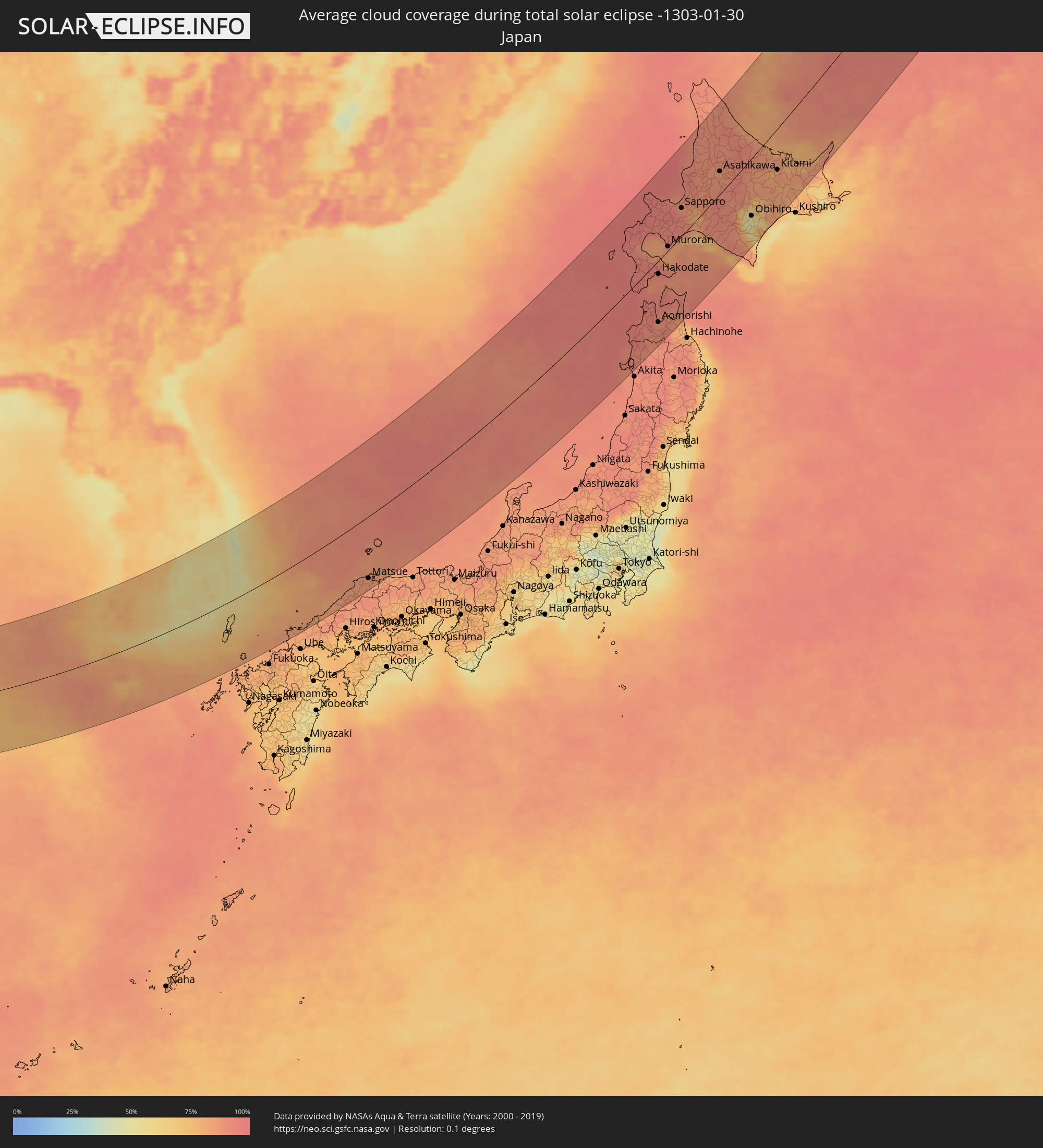 Japan
Japan
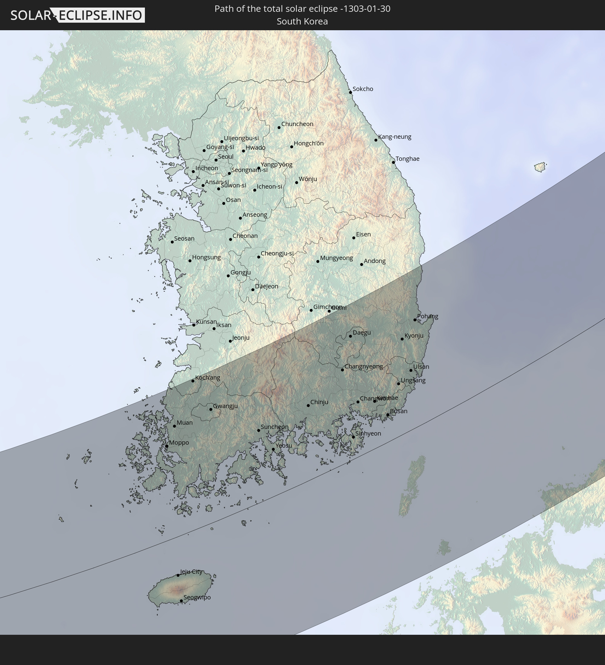
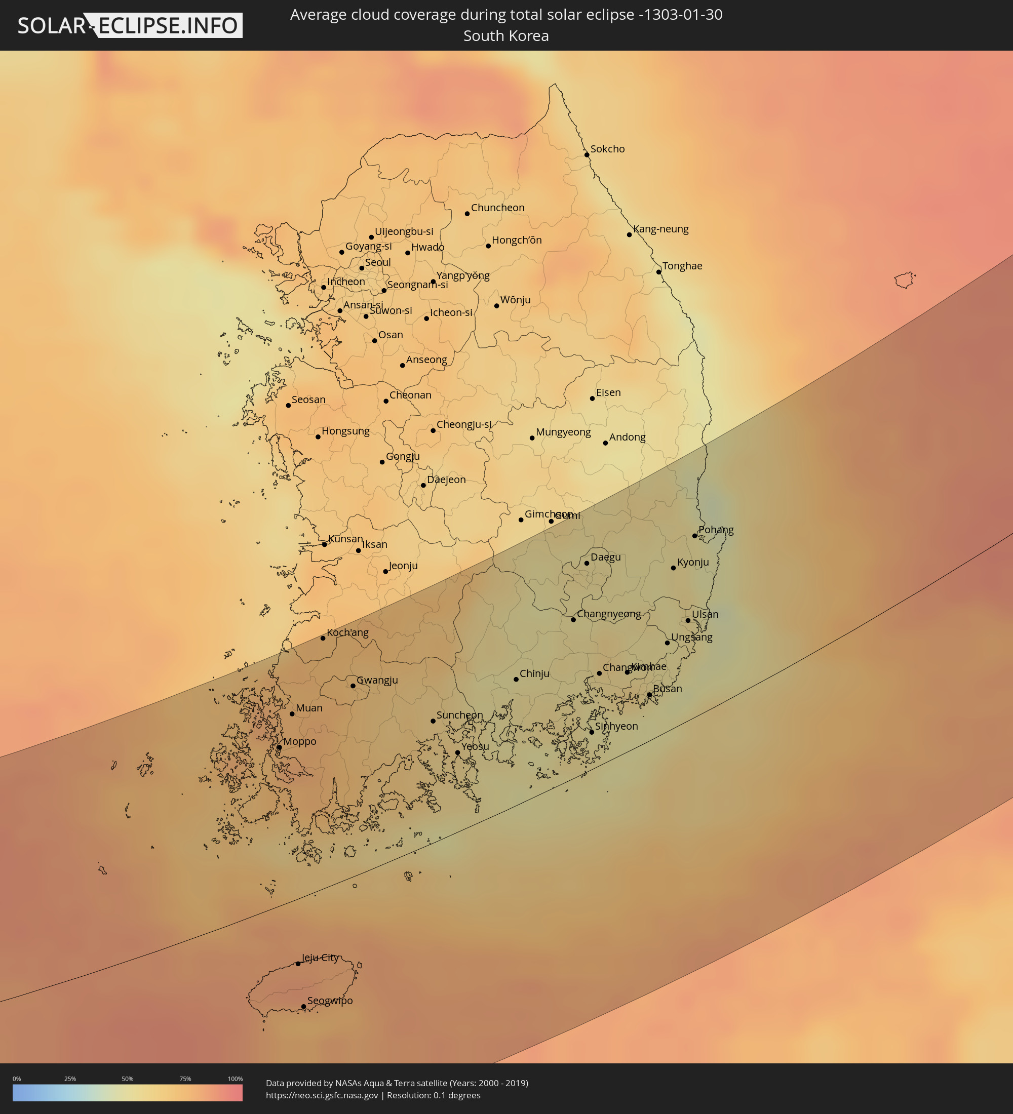 South Korea
Cities inside the path of the eclipse
The following table shows all locations with a population of more than 5,000 inside the eclipse path. Cities which have more than 100,000 inhabitants are marked bold. A click at the locations opens a detailed map.
| City | Type | Eclipse duration | Local time of max. eclipse | Distance to central line | Ø Cloud coverage |
|
Tianshui, Gansu
|
total | - | 09:30:59 UTC+08:00 | 104 km | 78% |
|
Beidao, Gansu
|
total | - | 09:31:09 UTC+08:00 | 106 km | 81% |
|
Hanzhong, Shaanxi
|
total | - | 09:30:23 UTC+08:00 | 29 km | 90% |
|
Guozhen, Shaanxi
|
total | - | 09:32:40 UTC+08:00 | 118 km | 86% |
|
Ankang, Shaanxi
|
total | - | 09:32:25 UTC+08:00 | 32 km | 86% |
|
Shiyan, Hubei
|
total | - | 09:34:48 UTC+08:00 | 7 km | 76% |
|
Shiyan, Hubei
|
total | - | 09:34:42 UTC+08:00 | 16 km | 76% |
|
Danjiangkou, Hubei
|
total | - | 09:35:43 UTC+08:00 | 9 km | 82% |
|
Gucheng Chengguanzhen, Hubei
|
total | - | 09:35:30 UTC+08:00 | 38 km | 84% |
|
Laohekou, Hubei
|
total | - | 09:35:43 UTC+08:00 | 24 km | 85% |
|
Nanzhang Chengguanzhen, Hubei
|
total | - | 09:35:07 UTC+08:00 | 88 km | 82% |
|
Xiangyang, Hubei
|
total | - | 09:35:57 UTC+08:00 | 56 km | 84% |
|
Nanyang, Henan
|
total | - | 09:37:52 UTC+08:00 | 53 km | 90% |
|
Yunyang, Henan
|
total | - | 09:38:47 UTC+08:00 | 105 km | 88% |
|
Zaoyang, Hubei
|
total | - | 09:36:59 UTC+08:00 | 41 km | 81% |
|
Binhe, Henan
|
total | - | 09:37:53 UTC+08:00 | 22 km | 86% |
|
Suizhou, Hubei
|
total | - | 09:37:20 UTC+08:00 | 81 km | 81% |
|
Xihe, Hubei
|
total | - | 09:37:28 UTC+08:00 | 83 km | 81% |
|
Anlu, Hubei
|
total | - | 09:37:12 UTC+08:00 | 129 km | 83% |
|
Guangshui, Hubei
|
total | - | 09:38:12 UTC+08:00 | 87 km | 84% |
|
Zhumadian, Henan
|
total | - | 09:40:09 UTC+08:00 | 64 km | 79% |
|
Luohe, Henan
|
total | - | 09:41:00 UTC+08:00 | 129 km | 83% |
|
Xinyang, Henan
|
total | - | 09:39:01 UTC+08:00 | 30 km | 80% |
|
Zhoukou, Henan
|
total | - | 09:42:02 UTC+08:00 | 141 km | 81% |
|
Macheng, Hubei
|
total | - | 09:39:15 UTC+08:00 | 130 km | 79% |
|
Huaidian, Henan
|
total | - | 09:42:24 UTC+08:00 | 120 km | 82% |
|
Dingcheng, Henan
|
total | - | 09:40:35 UTC+08:00 | 25 km | 79% |
|
Jieshou, Anhui
|
total | - | 09:42:41 UTC+08:00 | 102 km | 83% |
|
Fuyang, Anhui
|
total | - | 09:42:56 UTC+08:00 | 63 km | 87% |
|
Wuyang, Anhui
|
total | - | 09:42:23 UTC+08:00 | 38 km | 81% |
|
Mengcheng Chengguanzhen, Anhui
|
total | - | 09:44:41 UTC+08:00 | 104 km | 80% |
|
Suzhou, Anhui
|
total | - | 09:45:54 UTC+08:00 | 145 km | 82% |
|
Huainan, Anhui
|
total | - | 09:44:32 UTC+08:00 | 32 km | 81% |
|
Lucheng, Anhui
|
total | - | 09:43:06 UTC+08:00 | 123 km | 83% |
|
Hefei, Anhui
|
total | - | 09:43:58 UTC+08:00 | 53 km | 85% |
|
Bengbu, Anhui
|
total | - | 09:45:35 UTC+08:00 | 66 km | 81% |
|
Chaohu, Anhui
|
total | - | 09:44:38 UTC+08:00 | 85 km | 80% |
|
Chuzhou, Anhui
|
total | - | 09:46:22 UTC+08:00 | 7 km | 83% |
|
Wuhu, Anhui
|
total | - | 09:45:10 UTC+08:00 | 117 km | 81% |
|
Nanjing, Jiangsu
|
total | - | 09:46:52 UTC+08:00 | 39 km | 83% |
|
Huai'an, Jiangsu
|
total | - | 09:49:22 UTC+08:00 | 128 km | 85% |
|
Zhenzhou, Jiangsu
|
total | - | 09:47:52 UTC+08:00 | 18 km | 82% |
|
Baoying, Jiangsu
|
total | - | 09:49:24 UTC+08:00 | 86 km | 80% |
|
Yangzhou, Jiangsu
|
total | - | 09:48:30 UTC+08:00 | 7 km | 81% |
|
Gaoyou, Jiangsu
|
total | - | 09:49:03 UTC+08:00 | 36 km | 76% |
|
Zhenjiang, Jiangsu
|
total | - | 09:48:17 UTC+08:00 | 28 km | 82% |
|
Licheng, Jiangsu
|
total | - | 09:47:17 UTC+08:00 | 115 km | 77% |
|
Xiannü, Jiangsu
|
total | - | 09:48:46 UTC+08:00 | 5 km | 79% |
|
Yicheng, Jiangsu
|
total | - | 09:47:48 UTC+08:00 | 126 km | 80% |
|
Xinghua, Jiangsu
|
total | - | 09:49:57 UTC+08:00 | 48 km | 81% |
|
Taizhou, Jiangsu
|
total | - | 09:49:29 UTC+08:00 | 2 km | 84% |
|
Changzhou, Jiangsu
|
total | - | 09:48:36 UTC+08:00 | 82 km | 84% |
|
Taixing, Jiangsu
|
total | - | 09:49:15 UTC+08:00 | 39 km | 83% |
|
Jiangyan, Jiangsu
|
total | - | 09:49:56 UTC+08:00 | 3 km | 84% |
|
Yancheng, Jiangsu
|
total | - | 09:51:06 UTC+08:00 | 91 km | 84% |
|
Hede, Jiangsu
|
total | - | 09:51:51 UTC+08:00 | 135 km | 79% |
|
Jiangyin, Jiangsu
|
total | - | 09:49:21 UTC+08:00 | 70 km | 82% |
|
Wuxi, Jiangsu
|
total | - | 09:48:57 UTC+08:00 | 108 km | 84% |
|
Dongtai, Jiangsu
|
total | - | 09:50:42 UTC+08:00 | 33 km | 84% |
|
Dazhong, Jiangsu
|
total | - | 09:51:27 UTC+08:00 | 69 km | 80% |
|
Suzhou, Jiangsu
|
total | - | 09:49:10 UTC+08:00 | 141 km | 83% |
|
Changshu City, Jiangsu
|
total | - | 09:49:53 UTC+08:00 | 106 km | 82% |
|
Nantong, Jiangsu
|
total | - | 09:50:39 UTC+08:00 | 65 km | 83% |
|
Kunshan, Jiangsu
|
total | - | 09:49:56 UTC+08:00 | 138 km | 85% |
|
Jinsha, Jiangsu
|
total | - | 09:51:06 UTC+08:00 | 61 km | 85% |
|
Juegang, Jiangsu
|
total | - | 09:51:37 UTC+08:00 | 38 km | 80% |
|
Huilong, Jiangsu
|
total | - | 09:51:49 UTC+08:00 | 101 km | 86% |
|
Sinan, Jeollanam-do
|
total | - | 10:32:12 UTC+08:27 | 110 km | 77% |
|
Gaigeturi, Jeju-do
|
total | - | 10:30:56 UTC+08:27 | 39 km | 83% |
|
Moppo, Jeollanam-do
|
total | - | 10:32:43 UTC+08:27 | 97 km | 78% |
|
Muan, Jeollanam-do
|
total | - | 10:33:08 UTC+08:27 | 114 km | 76% |
|
Reiko, Jeollanam-do
|
total | - | 10:33:32 UTC+08:27 | 142 km | 76% |
|
Jeju City, Jeju-do
|
total | - | 10:31:24 UTC+08:27 | 41 km | 85% |
|
Seogwipo, Jeju-do
|
total | - | 10:31:09 UTC+08:27 | 69 km | 77% |
|
Haenam, Jeollanam-do
|
total | - | 10:32:51 UTC+08:27 | 66 km | 76% |
|
Koch'ang, Jeollabuk-do
|
total | - | 10:34:06 UTC+08:27 | 151 km | 73% |
|
Naju, Jeollanam-do
|
total | - | 10:33:39 UTC+08:27 | 109 km | 77% |
|
Gwangju, Gwangju
|
total | - | 10:34:12 UTC+08:27 | 115 km | 70% |
|
Hwasun, Jeollanam-do
|
total | - | 10:34:13 UTC+08:27 | 103 km | 68% |
|
Imsil, Jeollabuk-do
|
total | - | 10:35:28 UTC+08:27 | 148 km | 70% |
|
Beolgyo, Jeollanam-do
|
total | - | 10:34:40 UTC+08:27 | 68 km | 66% |
|
Nangen, Jeollabuk-do
|
total | - | 10:35:26 UTC+08:27 | 123 km | 68% |
|
Kurye, Jeollanam-do
|
total | - | 10:35:21 UTC+08:27 | 100 km | 62% |
|
Suncheon, Jeollanam-do
|
total | - | 10:35:05 UTC+08:27 | 73 km | 62% |
|
Changsu, Jeollabuk-do
|
total | - | 10:35:58 UTC+08:27 | 142 km | 67% |
|
Kwangyang, Jeollanam-do
|
total | - | 10:35:19 UTC+08:27 | 72 km | 60% |
|
Yeosu, Jeollanam-do
|
total | - | 10:35:13 UTC+08:27 | 47 km | 58% |
|
Chinju, Gyeongsangnam-do
|
total | - | 10:36:34 UTC+08:27 | 74 km | 53% |
|
Goseong, Gyeongsangnam-do
|
total | - | 10:36:47 UTC+08:27 | 43 km | 56% |
|
Waegwan, Gyeongsangbuk-do
|
total | - | 10:38:07 UTC+08:27 | 141 km | 52% |
|
Changnyeong, Gyeongsangnam-do
|
total | - | 10:37:47 UTC+08:27 | 92 km | 54% |
|
Hwawŏn, Daegu
|
total | - | 10:38:06 UTC+08:27 | 118 km | 52% |
|
Naesŏ, Gyeongsangnam-do
|
total | - | 10:37:30 UTC+08:27 | 62 km | 53% |
|
Kyosai, Gyeongsangnam-do
|
total | - | 10:37:10 UTC+08:27 | 20 km | 53% |
|
Daegu, Daegu
|
total | - | 10:38:22 UTC+08:27 | 121 km | 54% |
|
Sinhyeon, Gyeongsangnam-do
|
total | - | 10:37:17 UTC+08:27 | 21 km | 53% |
|
Changwon, Gyeongsangnam-do
|
total | - | 10:37:48 UTC+08:27 | 54 km | 55% |
|
Gyeongsan-si, Gyeongsangbuk-do
|
total | - | 10:38:36 UTC+08:27 | 110 km | 52% |
|
Miryang, Gyeongsangnam-do
|
total | - | 10:38:14 UTC+08:27 | 77 km | 59% |
|
Hayang, Gyeongsangbuk-do
|
total | - | 10:38:52 UTC+08:27 | 115 km | 52% |
|
Kimhae, Gyeongsangnam-do
|
total | - | 10:38:12 UTC+08:27 | 46 km | 61% |
|
Eisen, Gyeongsangbuk-do
|
total | - | 10:39:09 UTC+08:27 | 116 km | 53% |
|
Yangsan, Gyeongsangnam-do
|
total | - | 10:38:38 UTC+08:27 | 50 km | 56% |
|
Busan, Busan
|
total | - | 10:38:22 UTC+08:27 | 26 km | 53% |
|
Ungsang, Gyeongsangnam-do
|
total | - | 10:38:59 UTC+08:27 | 51 km | 53% |
|
Kyonju, Gyeongsangbuk-do
|
total | - | 10:39:34 UTC+08:27 | 92 km | 54% |
|
Gijang, Busan
|
total | - | 10:38:53 UTC+08:27 | 33 km | 49% |
|
Ulsan, Ulsan
|
total | - | 10:39:26 UTC+08:27 | 57 km | 54% |
|
Heunghae, Gyeongsangbuk-do
|
total | - | 10:40:08 UTC+08:27 | 112 km | 53% |
|
Yeonil, Gyeongsangbuk-do
|
total | - | 10:40:01 UTC+08:27 | 100 km | 51% |
|
Pohang, Gyeongsangbuk-do
|
total | - | 10:40:05 UTC+08:27 | 103 km | 51% |
|
Nagato, Yamaguchi
|
total | - | 11:14:05 UTC+09:00 | 138 km | 82% |
|
Hagi, Yamaguchi
|
total | - | 11:14:33 UTC+09:00 | 147 km | 84% |
|
Masuda, Shimane
|
total | - | 11:15:44 UTC+09:00 | 141 km | 83% |
|
Hamada, Shimane
|
total | - | 11:16:27 UTC+09:00 | 131 km | 84% |
|
Gōtsuchō, Shimane
|
total | - | 11:16:52 UTC+09:00 | 126 km | 83% |
|
Ōdachō-ōda, Shimane
|
total | - | 11:17:39 UTC+09:00 | 123 km | 85% |
|
Izumo, Shimane
|
total | - | 11:18:21 UTC+09:00 | 119 km | 85% |
|
Hiratachō, Shimane
|
total | - | 11:18:32 UTC+09:00 | 115 km | 85% |
|
Matsue, Shimane
|
total | - | 11:19:03 UTC+09:00 | 122 km | 85% |
|
Sakaiminato, Shimane
|
total | - | 11:19:30 UTC+09:00 | 125 km | 84% |
|
Yasugichō, Shimane
|
total | - | 11:19:23 UTC+09:00 | 137 km | 86% |
|
Yonago, Tottori
|
total | - | 11:19:35 UTC+09:00 | 141 km | 85% |
|
Tennō, Akita
|
total | - | 11:36:32 UTC+09:00 | 122 km | 90% |
|
Noshiro, Akita
|
total | - | 11:36:52 UTC+09:00 | 101 km | 92% |
|
Takanosu, Akita
|
total | - | 11:37:30 UTC+09:00 | 120 km | 90% |
|
Shimokizukuri, Aomori
|
total | - | 11:37:56 UTC+09:00 | 74 km | 92% |
|
Goshogawara, Aomori
|
total | - | 11:38:02 UTC+09:00 | 78 km | 92% |
|
Hirosaki, Aomori
|
total | - | 11:37:57 UTC+09:00 | 97 km | 89% |
|
Iwanai, Hokkaido
|
total | - | 11:39:33 UTC+09:00 | 85 km | 96% |
|
Ōdate, Akita
|
total | - | 11:37:53 UTC+09:00 | 127 km | 88% |
|
Kuroishi, Aomori
|
total | - | 11:38:11 UTC+09:00 | 99 km | 90% |
|
Namioka, Aomori
|
total | - | 11:38:15 UTC+09:00 | 95 km | 90% |
|
Kamiiso, Hokkaido
|
total | - | 11:39:05 UTC+09:00 | 11 km | 91% |
|
Nanae, Hokkaido
|
total | - | 11:39:11 UTC+09:00 | 9 km | 93% |
|
Aomorishi, Aomori
|
total | - | 11:38:35 UTC+09:00 | 95 km | 91% |
|
Hakodate, Hokkaido
|
total | - | 11:39:13 UTC+09:00 | 20 km | 90% |
|
Yoichi, Hokkaido
|
total | - | 11:40:09 UTC+09:00 | 86 km | 94% |
|
Date, Hokkaido
|
total | - | 11:39:53 UTC+09:00 | 25 km | 91% |
|
Muroran, Hokkaido
|
total | - | 11:40:00 UTC+09:00 | 6 km | 82% |
|
Otaru, Hokkaido
|
total | - | 11:40:33 UTC+09:00 | 71 km | 93% |
|
Mutsu, Aomori
|
total | - | 11:39:46 UTC+09:00 | 87 km | 91% |
|
Shiraoi, Hokkaido
|
total | - | 11:40:46 UTC+09:00 | 2 km | 82% |
|
Sapporo, Hokkaido
|
total | - | 11:41:05 UTC+09:00 | 41 km | 86% |
|
Ishikari, Hokkaido
|
total | - | 11:41:11 UTC+09:00 | 54 km | 87% |
|
Tōbetsu, Hokkaido
|
total | - | 11:41:27 UTC+09:00 | 42 km | 86% |
|
Ebetsu, Hokkaido
|
total | - | 11:41:27 UTC+09:00 | 32 km | 83% |
|
Kitahiroshima, Hokkaido
|
total | - | 11:41:24 UTC+09:00 | 21 km | 82% |
|
Tomakomai, Hokkaido
|
total | - | 11:41:16 UTC+09:00 | 6 km | 69% |
|
Rumoi, Hokkaido
|
total | - | 11:42:04 UTC+09:00 | 88 km | 92% |
|
Chitose, Hokkaido
|
total | - | 11:41:27 UTC+09:00 | 5 km | 85% |
|
Iwamizawa, Hokkaido
|
total | - | 11:41:52 UTC+09:00 | 27 km | 84% |
|
Bibai, Hokkaido
|
total | - | 11:42:06 UTC+09:00 | 30 km | 87% |
|
Sunagawa, Hokkaido
|
total | - | 11:42:16 UTC+09:00 | 39 km | 88% |
|
Takikawa, Hokkaido
|
total | - | 11:42:18 UTC+09:00 | 44 km | 89% |
|
Fukagawa, Hokkaido
|
total | - | 11:42:37 UTC+09:00 | 48 km | 88% |
|
Utashinai, Hokkaido
|
total | - | 11:42:32 UTC+09:00 | 33 km | 89% |
|
Akabira, Hokkaido
|
total | - | 11:42:33 UTC+09:00 | 35 km | 88% |
|
Ashibetsu, Hokkaido
|
total | - | 11:42:46 UTC+09:00 | 24 km | 90% |
|
Asahikawa, Hokkaido
|
total | - | 11:43:12 UTC+09:00 | 33 km | 87% |
|
Shizunai-furukawachō, Hokkaido
|
total | - | 11:42:25 UTC+09:00 | 75 km | 77% |
|
Shimo-furano, Hokkaido
|
total | - | 11:43:01 UTC+09:00 | 1 km | 91% |
|
Nayoro, Hokkaido
|
total | - | 11:43:39 UTC+09:00 | 69 km | 90% |
|
Kamikawa, Hokkaido
|
total | - | 11:43:55 UTC+09:00 | 13 km | 91% |
|
Otofuke, Hokkaido
|
total | - | 11:44:13 UTC+09:00 | 76 km | 55% |
|
Obihiro, Hokkaido
|
total | - | 11:44:11 UTC+09:00 | 82 km | 47% |
|
Mombetsu, Hokkaido
|
total | - | 11:45:09 UTC+09:00 | 16 km | 84% |
|
Kitami, Hokkaido
|
total | - | 11:45:47 UTC+09:00 | 57 km | 85% |
|
Bihoro, Hokkaido
|
total | - | 11:46:09 UTC+09:00 | 68 km | 82% |
|
Abashiri, Hokkaido
|
total | - | 11:46:31 UTC+09:00 | 64 km | 80% |