Total solar eclipse of 09/15/-1362
| Day of week: | Thursday |
| Maximum duration of eclipse: | 02m10s |
| Maximum width of eclipse path: | 82 km |
| Saros cycle: | 32 |
| Coverage: | 100% |
| Magnitude: | 1.024 |
| Gamma: | -0.0924 |
Wo kann man die Sonnenfinsternis vom 09/15/-1362 sehen?
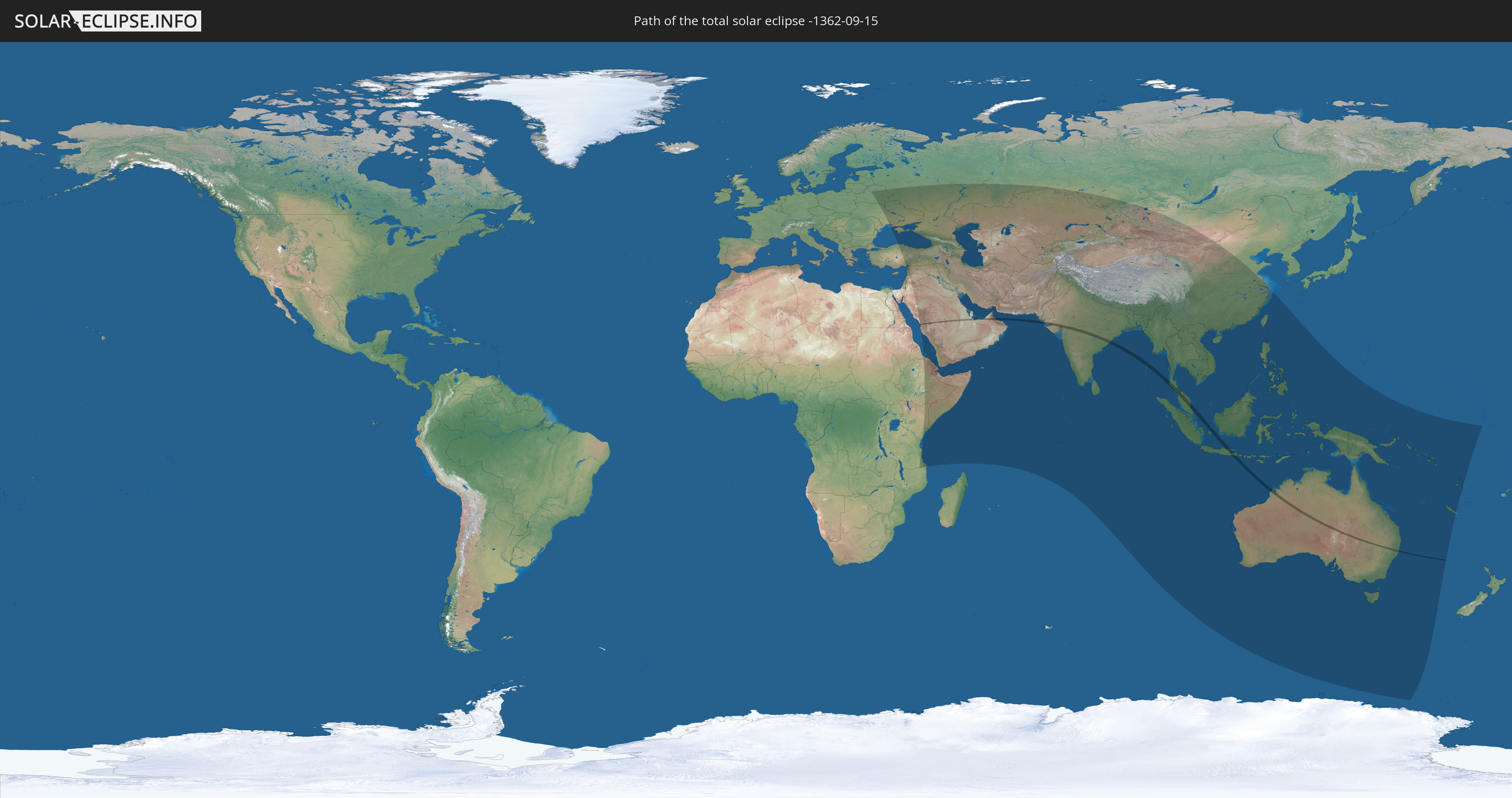
Die Sonnenfinsternis am 09/15/-1362 kann man in 69 Ländern als partielle Sonnenfinsternis beobachten.
Der Finsternispfad verläuft durch 9 Länder. Nur in diesen Ländern ist sie als total Sonnenfinsternis zu sehen.
In den folgenden Ländern ist die Sonnenfinsternis total zu sehen
 Saudi Arabia
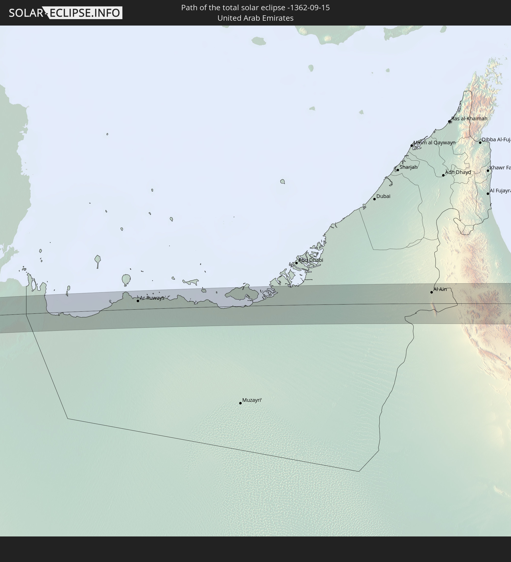 United Arab Emirates
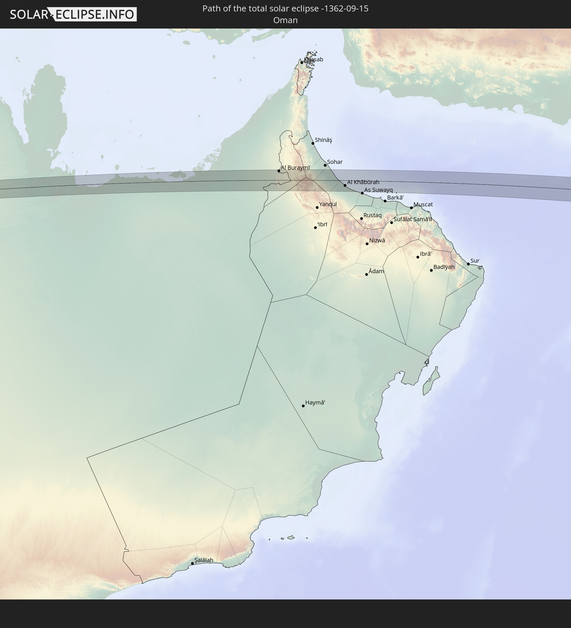 Oman
Oman
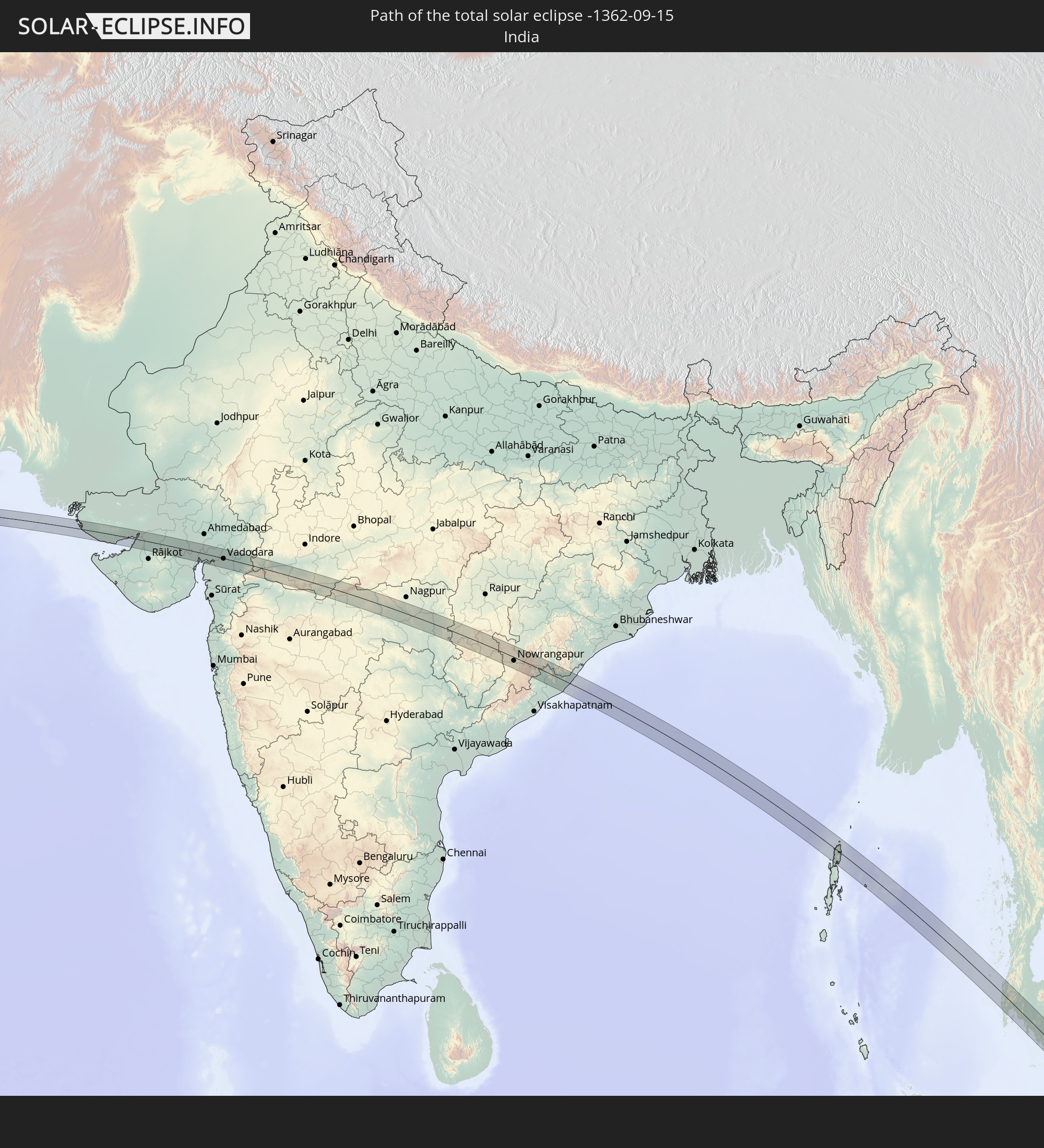 India
India
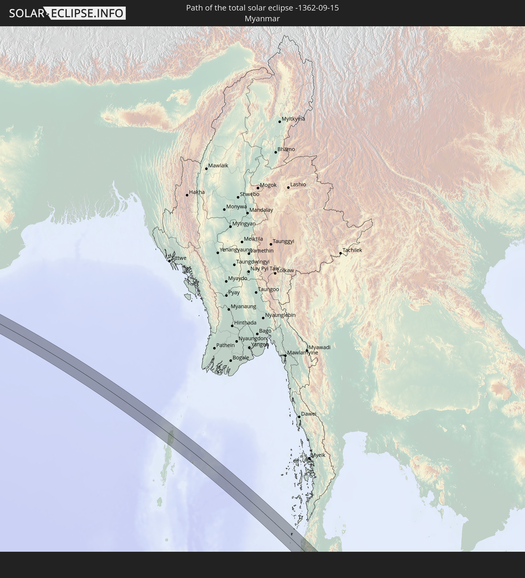 Myanmar
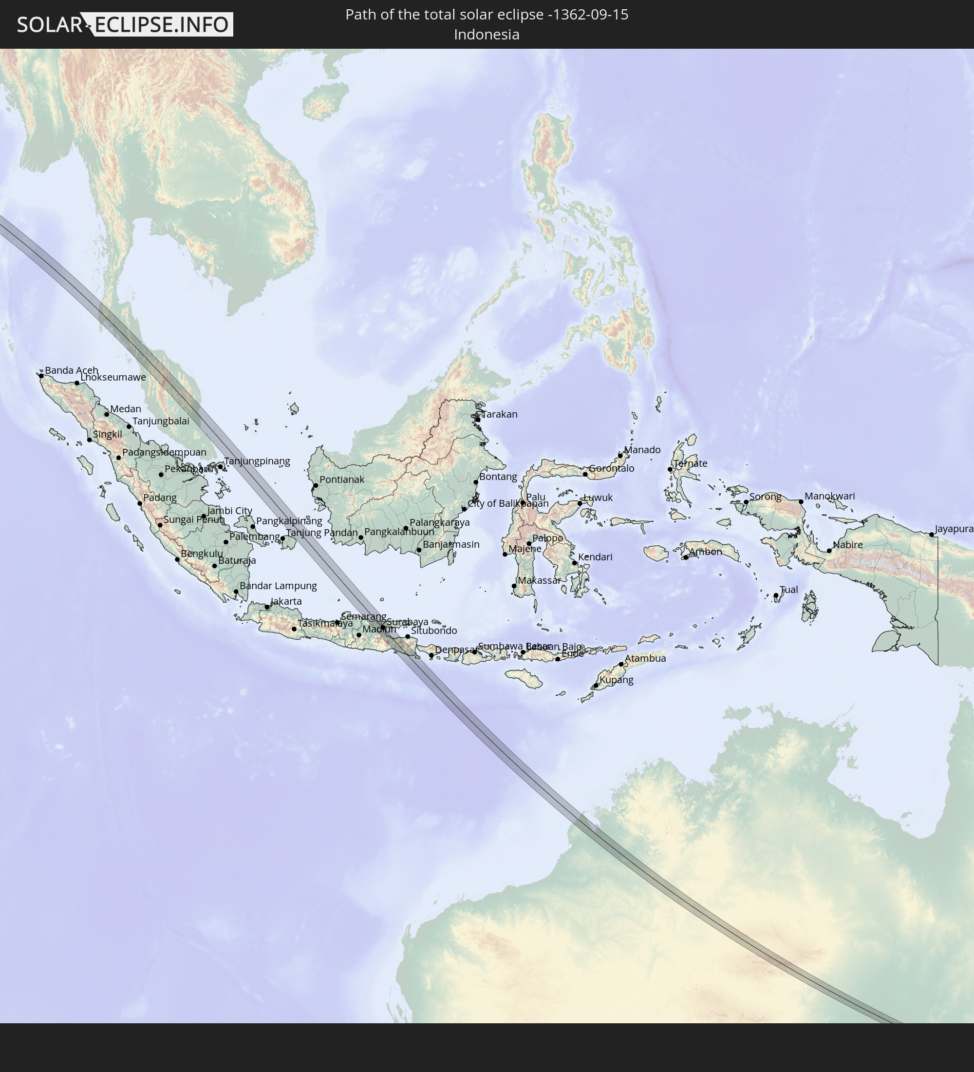 Indonesia
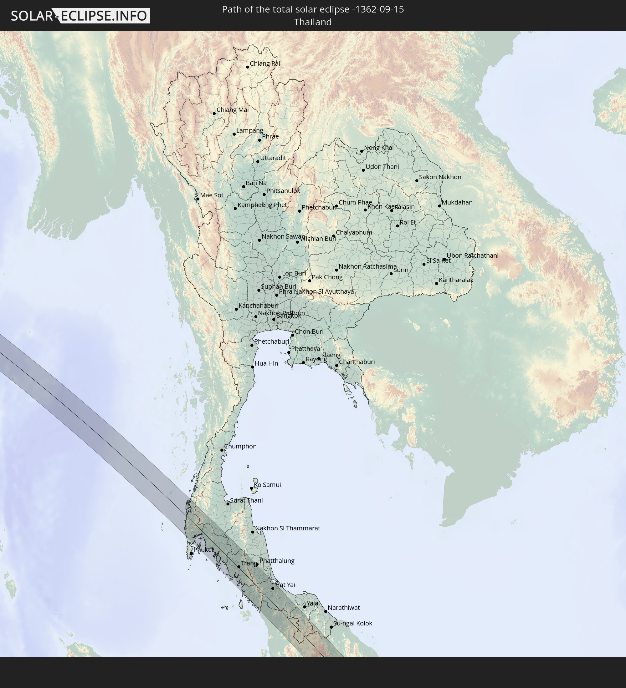 Thailand
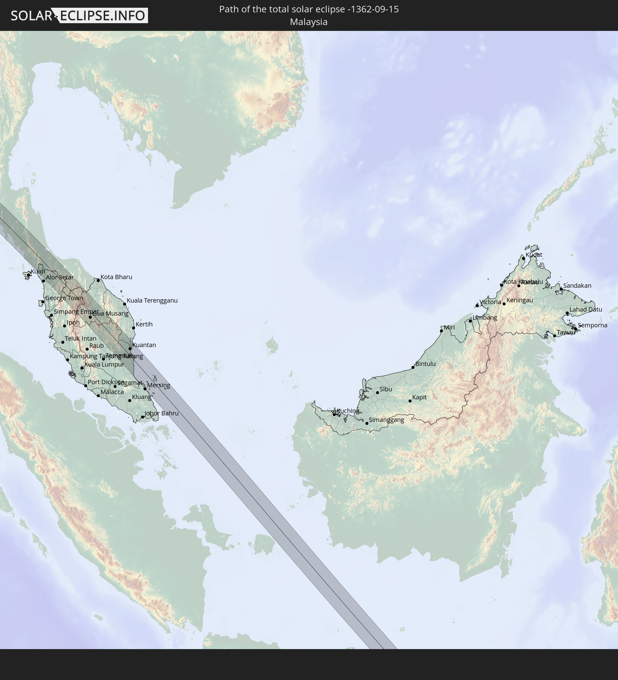 Malaysia
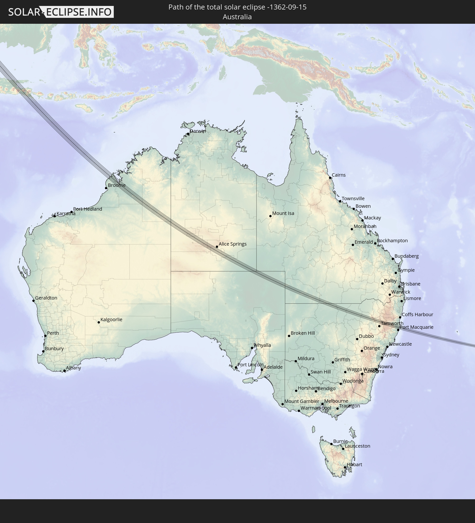 Australia
In den folgenden Ländern ist die Sonnenfinsternis partiell zu sehen
 Russia
 Ukraine
 Belarus
 Turkey
 Tanzania
 Mozambique
 Ethiopia
 Kenya
Kenya
 Saudi Arabia
 Jordan
 Lebanon
 Syria
Syria
 Eritrea
 Iraq
Iraq
 Georgia
 Somalia
 Djibouti
 Yemen
Yemen
 Armenia
 Iran
Iran
 Azerbaijan
 Seychelles
 Kazakhstan
 Kuwait
 Bahrain
 Qatar
Qatar
 United Arab Emirates
 Oman
Oman
 Turkmenistan
 Uzbekistan
 Mauritius
 Afghanistan
 Pakistan
 Tajikistan
 India
India
 Kyrgyzstan
 British Indian Ocean Territory
 Maldives
 China
China
 Sri Lanka
 Nepal
Nepal
 Mongolia
 Bangladesh
 Bhutan
 Myanmar
 Indonesia
 Cocos Islands
 Thailand
 Malaysia
 Laos
Laos
 Vietnam
 Cambodia
 Singapore
 Christmas Island
 Australia
 Macau
Macau
 Hong Kong
 Brunei
 Taiwan
 Philippines
 Japan
Japan
 East Timor
 Palau
Palau
 Federated States of Micronesia
 Papua New Guinea
 Solomon Islands
 New Caledonia
 Vanuatu
 Nauru
Nauru
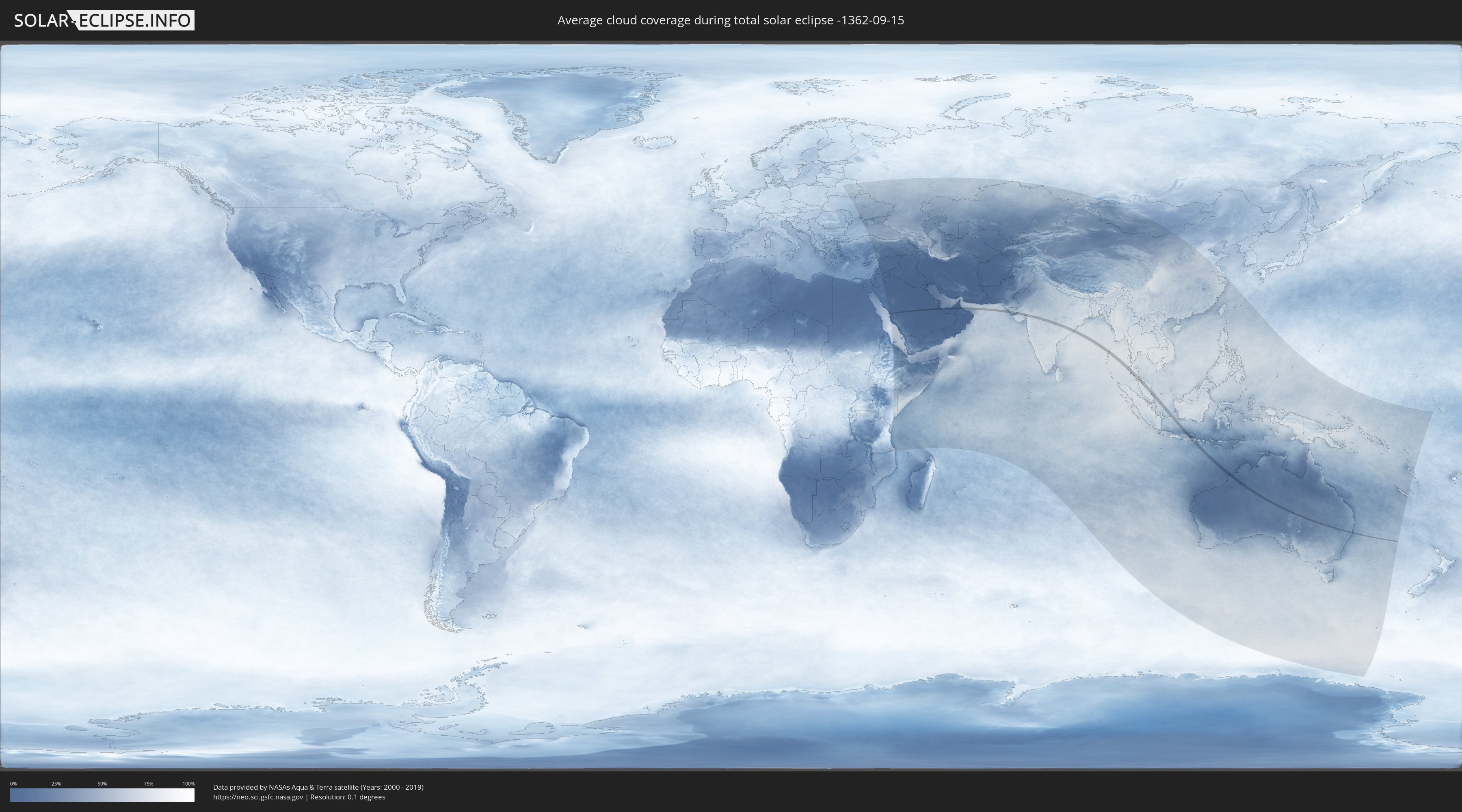
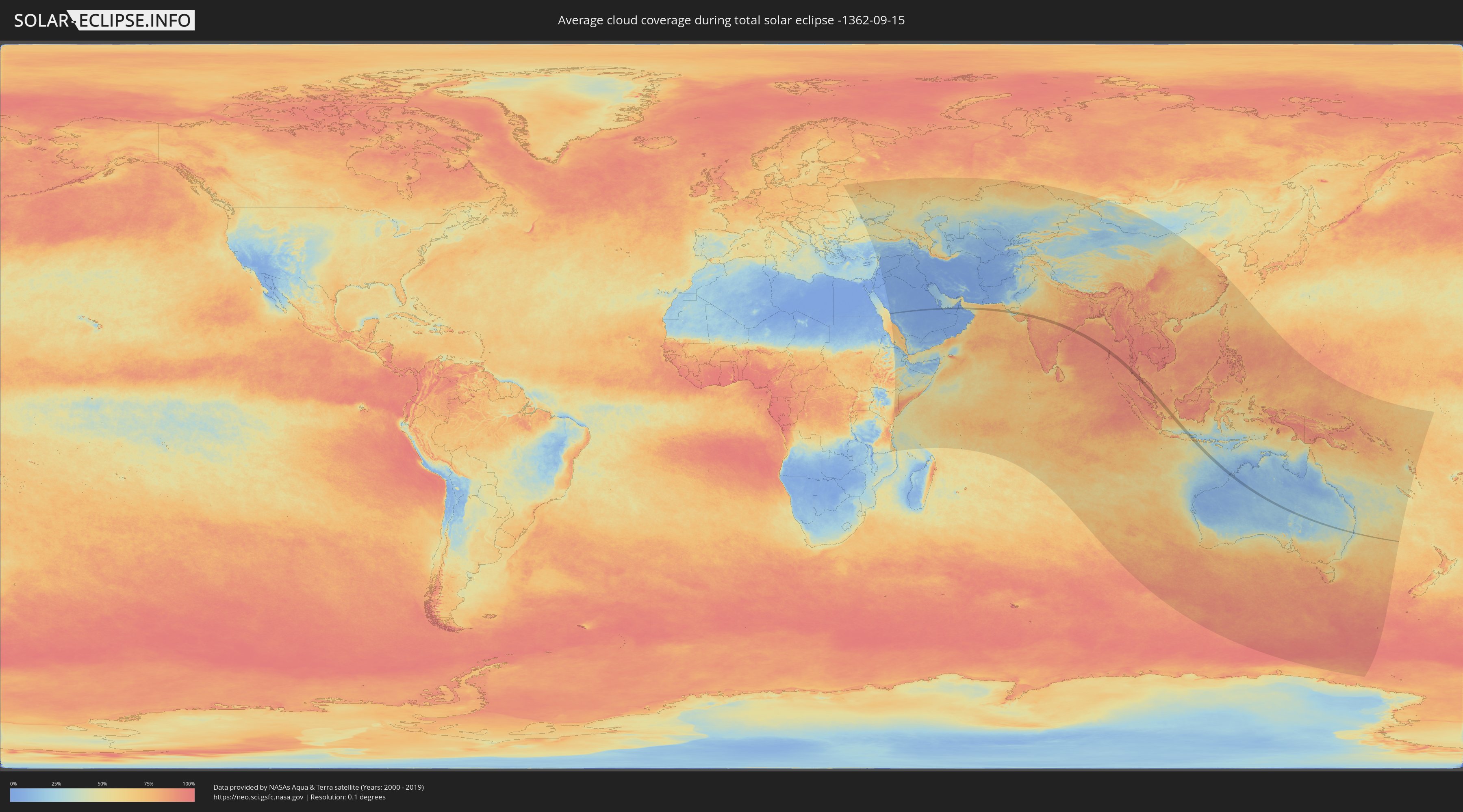
How will be the weather during the total solar eclipse on 09/15/-1362?
Where is the best place to see the total solar eclipse of 09/15/-1362?
The following maps show the average cloud coverage for the day of the total solar eclipse.
With the help of these maps, it is possible to find the place along the eclipse path, which has the best
chance of a cloudless sky.
Nevertheless, you should consider local circumstances and inform about the weather of your chosen
observation site.
The data is provided by NASAs satellites
AQUA and TERRA.
The cloud maps are averaged over a period of 19 years (2000 - 2019).
Detailed country maps
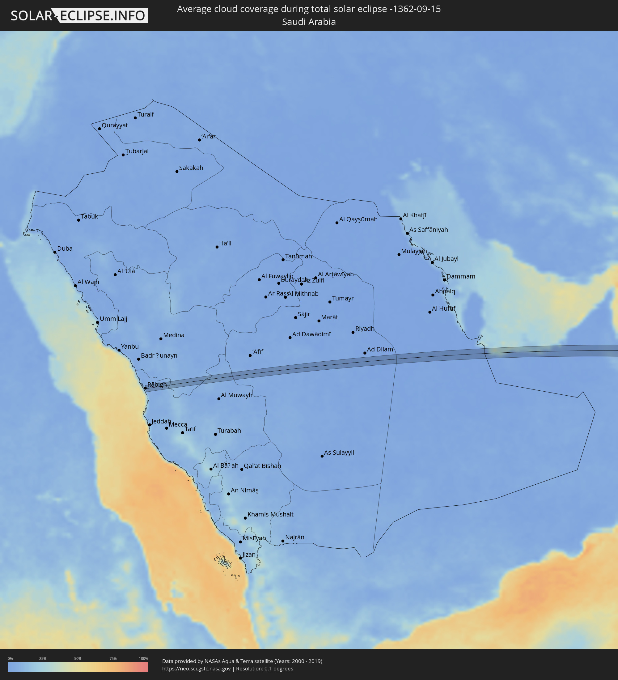 Saudi Arabia
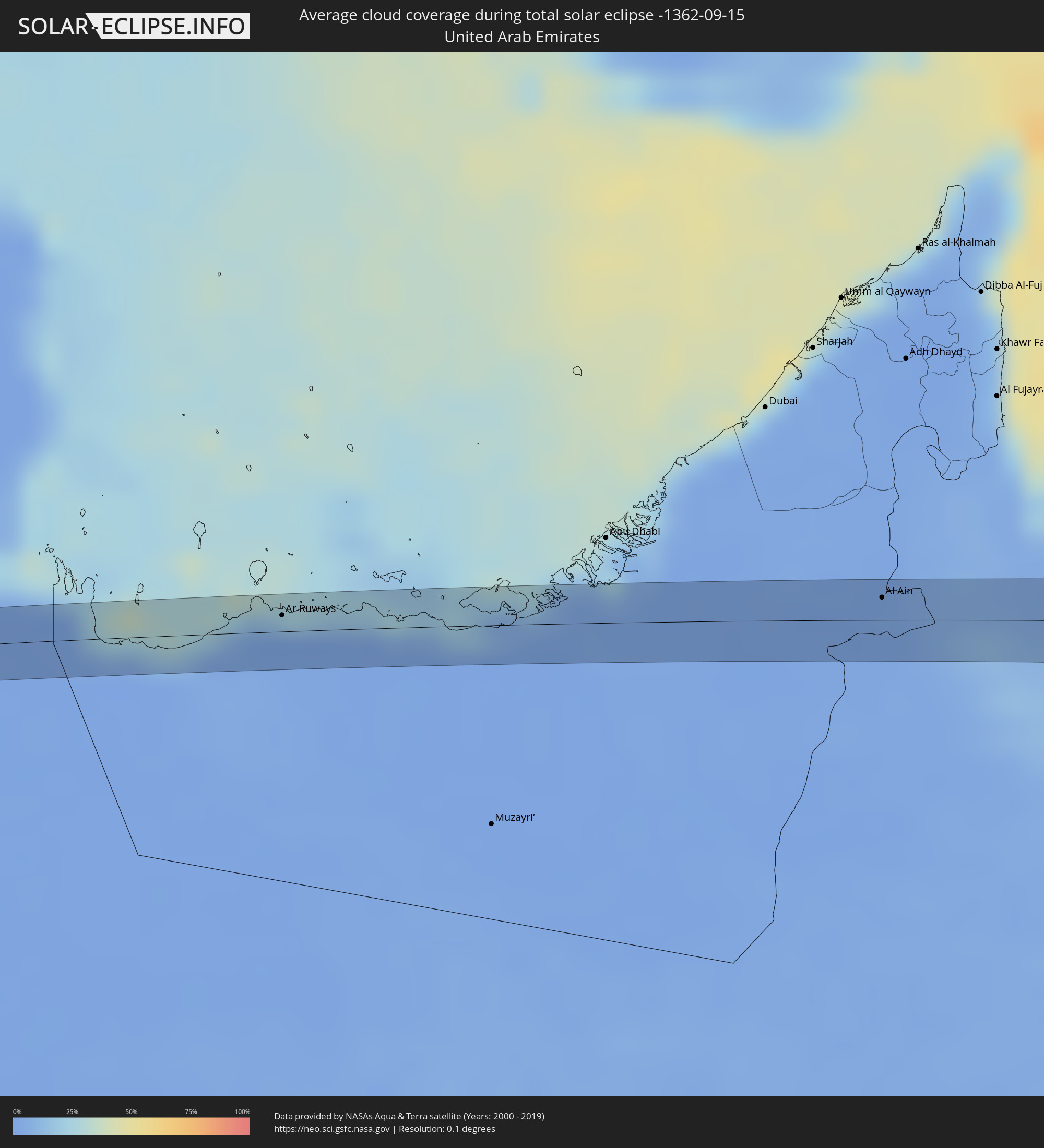 United Arab Emirates
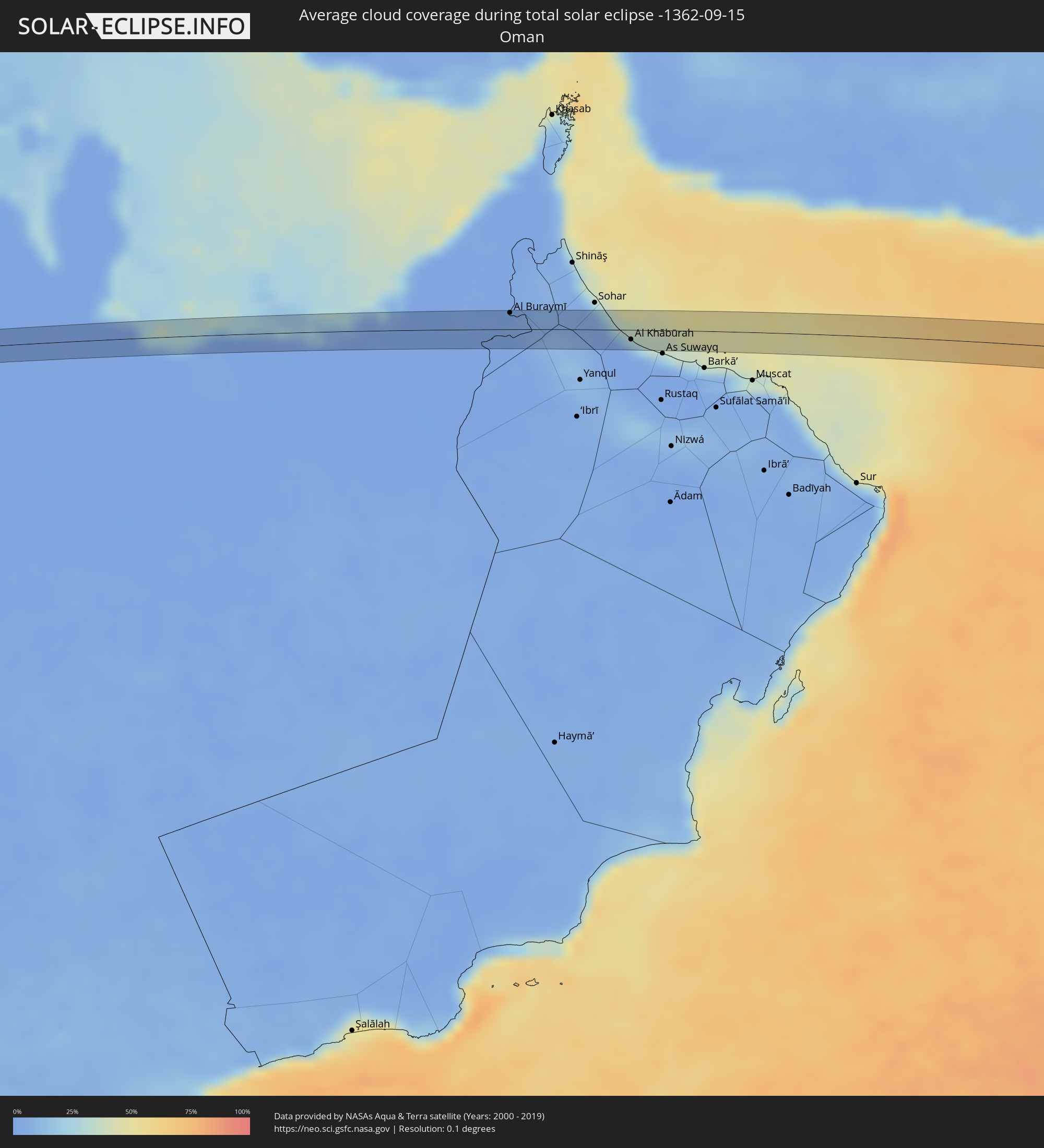 Oman
Oman
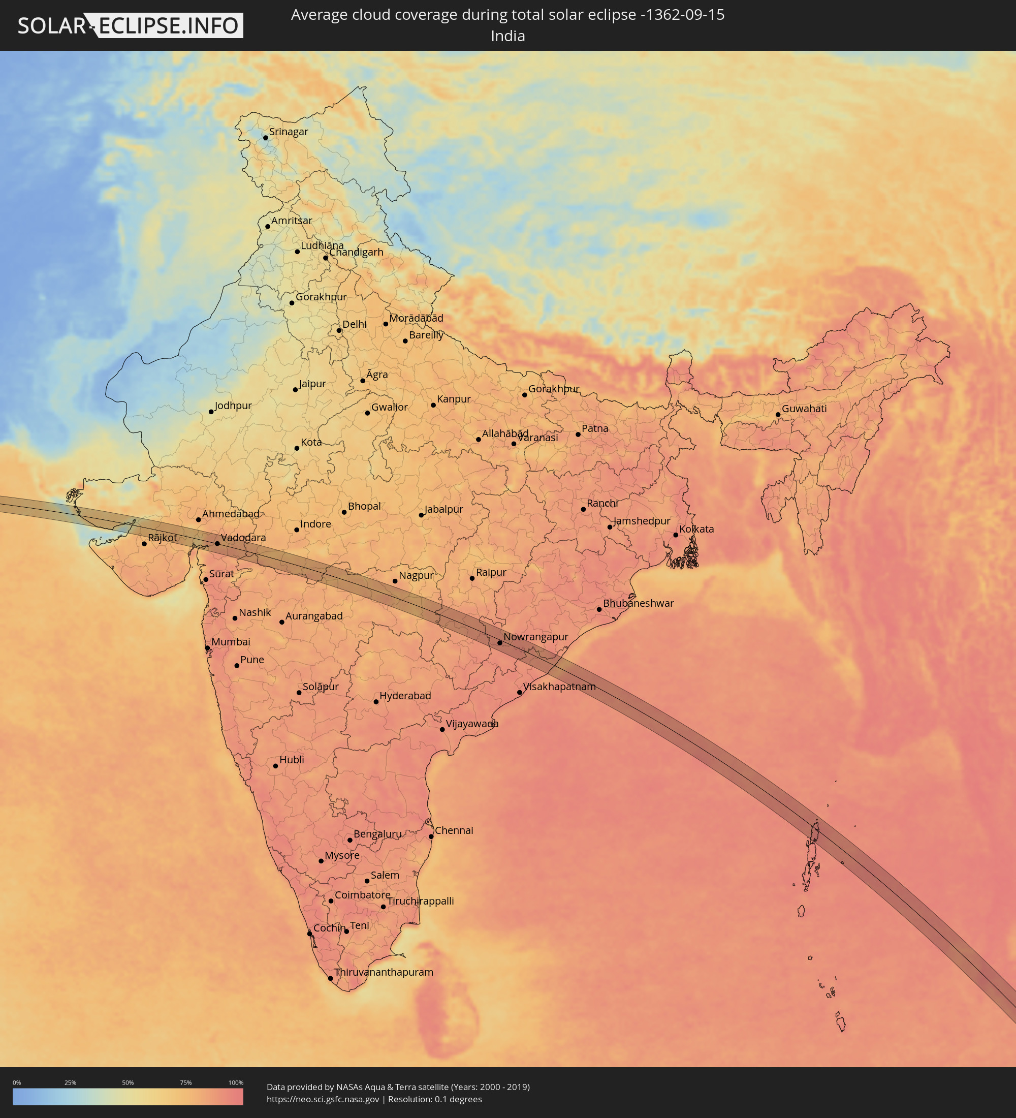 India
India
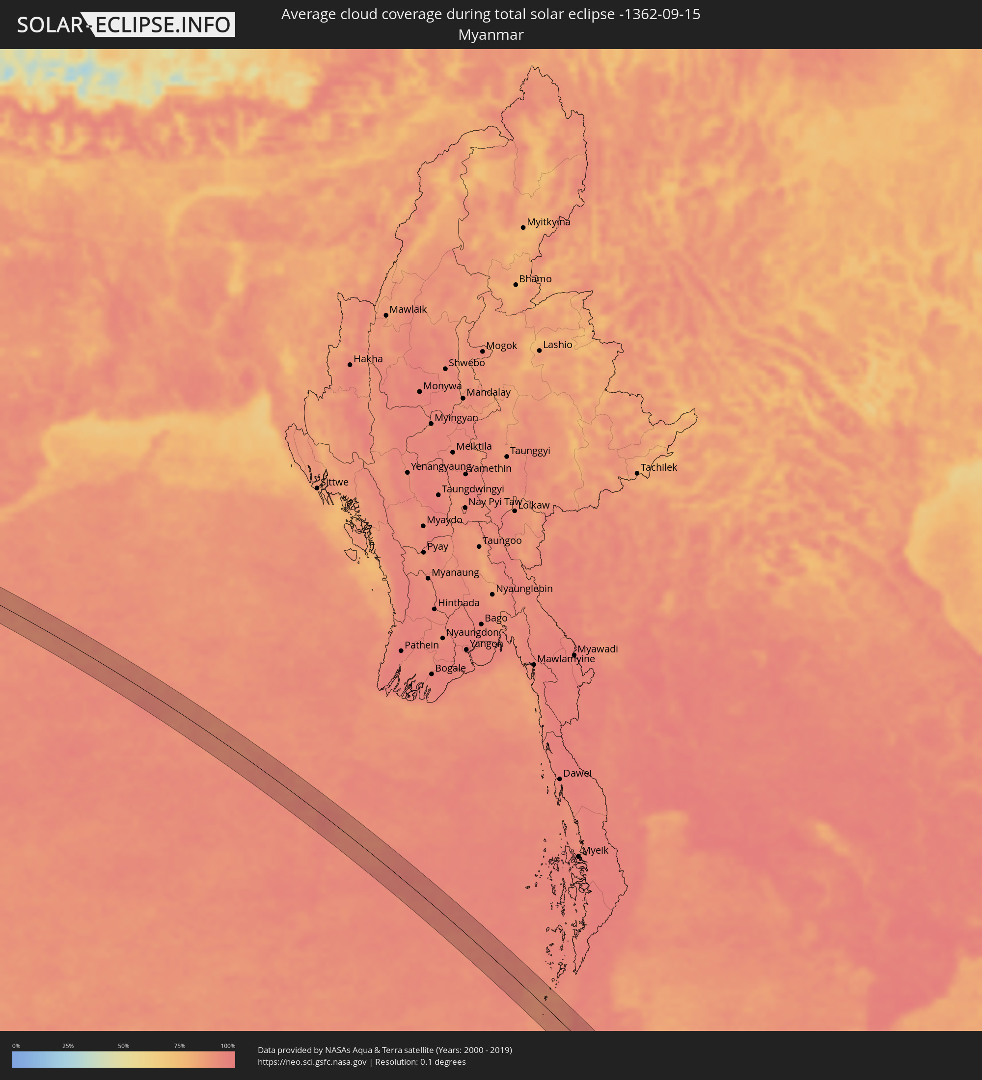 Myanmar
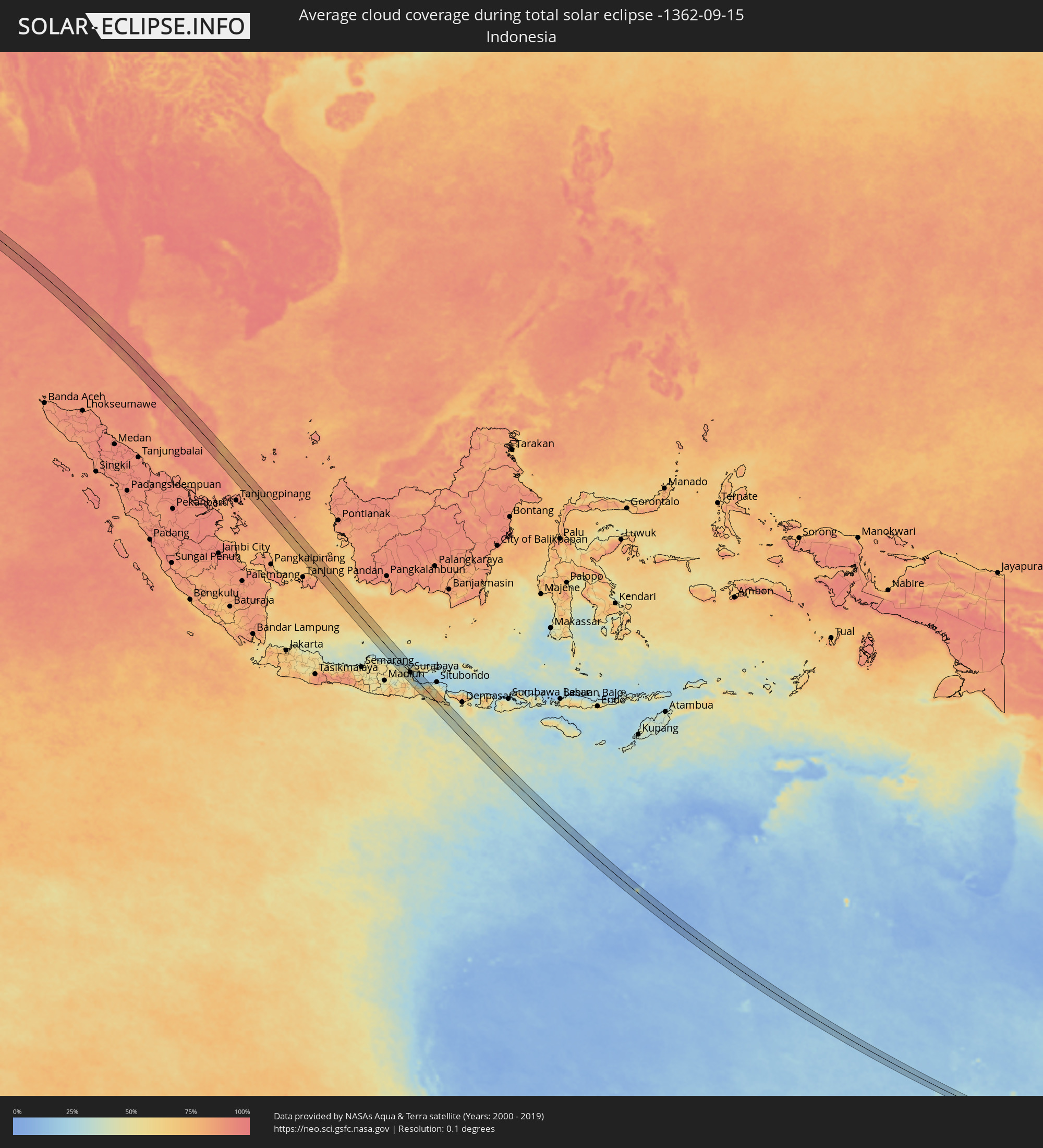 Indonesia
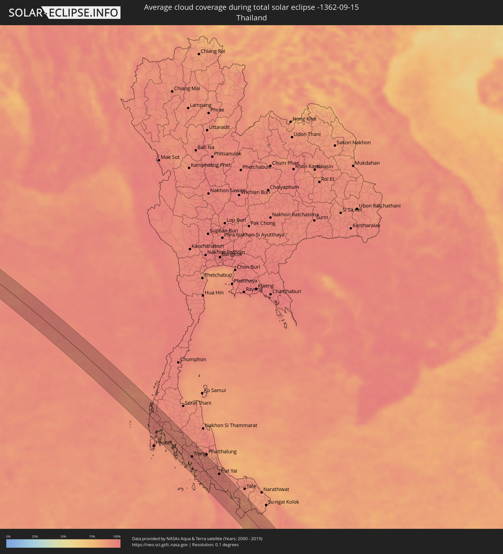 Thailand
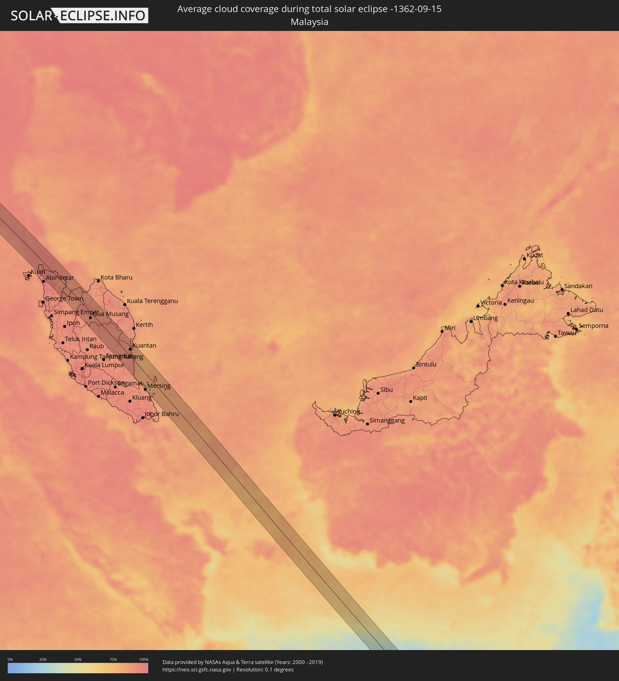 Malaysia
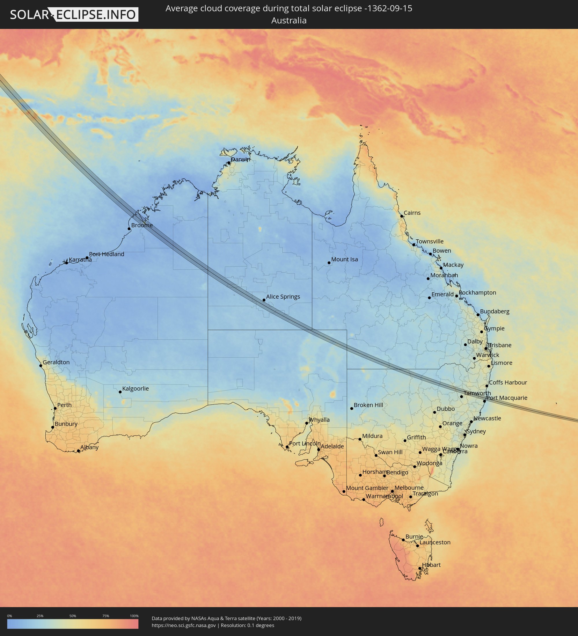 Australia
Cities inside the path of the eclipse
The following table shows all locations with a population of more than 5,000 inside the eclipse path. Cities which have more than 100,000 inhabitants are marked bold. A click at the locations opens a detailed map.
| City | Type | Eclipse duration | Local time of max. eclipse | Distance to central line | Ø Cloud coverage |
|
Ar Ruways, Abu Dhabi
|
total | - | 06:54:14 UTC+03:41 | 8 km | 1% |
|
Al Ain, Abu Dhabi
|
total | - | 06:55:43 UTC+03:41 | 12 km | 2% |
|
Al Buraymī, Al Buraimi
|
total | - | 06:55:43 UTC+03:41 | 18 km | 2% |
|
Şaḩam, Al Batinah North Governorate
|
total | - | 06:56:21 UTC+03:41 | 10 km | 19% |
|
Al Khābūrah, Al Batinah North Governorate
|
total | - | 06:56:31 UTC+03:41 | 10 km | 11% |
|
Māndvi, Gujarat
|
total | - | 08:47:12 UTC+05:21 | 25 km | 39% |
|
Bhuj, Gujarat
|
total | - | 08:47:19 UTC+05:21 | 27 km | 68% |
|
Gāndhīdhām, Gujarat
|
total | - | 08:47:55 UTC+05:21 | 17 km | 59% |
|
Morbi, Gujarat
|
total | - | 08:48:52 UTC+05:21 | 2 km | 73% |
|
Wānkāner, Gujarat
|
total | - | 08:49:06 UTC+05:21 | 18 km | 75% |
|
Thān, Gujarat
|
total | - | 08:49:25 UTC+05:21 | 17 km | 74% |
|
Surendranagar, Gujarat
|
total | - | 08:49:51 UTC+05:21 | 9 km | 75% |
|
Dholka, Gujarat
|
total | - | 08:50:48 UTC+05:21 | 27 km | 68% |
|
Khambhāt, Gujarat
|
total | - | 08:51:17 UTC+05:21 | 13 km | 76% |
|
Borsad, Gujarat
|
total | - | 08:51:34 UTC+05:21 | 3 km | 78% |
|
Ānand, Gujarat
|
total | - | 08:51:32 UTC+05:21 | 20 km | 85% |
|
Vadodara, Gujarat
|
total | - | 08:52:01 UTC+05:21 | 1 km | 85% |
|
Dabhoi, Gujarat
|
total | - | 08:52:23 UTC+05:21 | 8 km | 86% |
|
Hālol, Gujarat
|
total | - | 08:52:13 UTC+05:21 | 27 km | 77% |
|
Barwāni, Madhya Pradesh
|
total | - | 08:54:22 UTC+05:21 | 14 km | 79% |
|
Sendhwa, Madhya Pradesh
|
total | - | 08:54:53 UTC+05:21 | 18 km | 79% |
|
Khargone, Madhya Pradesh
|
total | - | 08:55:28 UTC+05:21 | 12 km | 80% |
|
Burhānpur, Madhya Pradesh
|
total | - | 08:56:43 UTC+05:21 | 25 km | 82% |
|
Akot, Maharashtra
|
total | - | 08:58:03 UTC+05:21 | 22 km | 78% |
|
Anjangaon, Maharashtra
|
total | - | 08:58:21 UTC+05:21 | 7 km | 79% |
|
Achalpur, Maharashtra
|
total | - | 08:58:34 UTC+05:21 | 10 km | 78% |
|
Amrāvati, Maharashtra
|
total | - | 08:59:11 UTC+05:21 | 17 km | 77% |
|
Wardha, Maharashtra
|
total | - | 09:00:36 UTC+05:21 | 8 km | 82% |
|
Hinganghāt, Maharashtra
|
total | - | 09:01:08 UTC+05:21 | 20 km | 82% |
|
Umred, Maharashtra
|
total | - | 09:01:34 UTC+05:21 | 29 km | 79% |
|
Nowrangapur, Odisha
|
total | - | 09:08:19 UTC+05:21 | 11 km | 90% |
|
Pārvatipuram, Andhra Pradesh
|
total | - | 09:10:18 UTC+05:21 | 18 km | 89% |
|
Parlākimidi, Andhra Pradesh
|
total | - | 09:11:25 UTC+05:21 | 12 km | 87% |
|
Palāsa, Andhra Pradesh
|
total | - | 09:11:58 UTC+05:21 | 26 km | 87% |
|
Phang Nga, Phangnga
|
total | - | 11:17:27 UTC+06:42 | 12 km | 95% |
|
Ao Luek, Krabi
|
total | - | 11:17:59 UTC+06:42 | 3 km | 91% |
|
Ban Ao Nang, Phangnga
|
total | - | 11:18:51 UTC+06:42 | 22 km | 89% |
|
Krabi, Krabi
|
total | - | 11:19:00 UTC+06:42 | 12 km | 91% |
|
Nuea Khlong, Krabi
|
total | - | 11:19:11 UTC+06:42 | 5 km | 92% |
|
Saladan, Krabi
|
total | - | 11:20:12 UTC+06:42 | 39 km | 86% |
|
Chai Buri, Surat Thani
|
total | - | 11:18:31 UTC+06:42 | 32 km | 91% |
|
Ko Lanta, Krabi
|
total | - | 11:20:28 UTC+06:42 | 41 km | 87% |
|
Kantang, Trang
|
total | - | 11:21:36 UTC+06:42 | 17 km | 89% |
|
Trang, Trang
|
total | - | 11:21:29 UTC+06:42 | 2 km | 94% |
|
Huai Yot, Trang
|
total | - | 11:21:02 UTC+06:42 | 22 km | 93% |
|
Satun, Satun
|
total | - | 11:24:22 UTC+06:42 | 35 km | 90% |
|
Kangar, Perlis
|
total | - | 11:38:22 UTC+06:55 | 38 km | 94% |
|
Jitra, Kedah
|
total | - | 11:39:11 UTC+06:55 | 34 km | 97% |
|
Sadao, Songkhla
|
total | - | 11:25:03 UTC+06:42 | 5 km | 94% |
|
Hat Yai, Songkhla
|
total | - | 11:24:22 UTC+06:42 | 28 km | 95% |
|
Na Mom, Songkhla
|
total | - | 11:24:38 UTC+06:42 | 30 km | 94% |
|
Betong, Yala
|
total | - | 11:28:12 UTC+06:42 | 19 km | 91% |
|
Gua Musang, Kelantan
|
total | - | 11:45:15 UTC+06:55 | 14 km | 89% |
|
Kuantan, Pahang
|
total | - | 11:50:16 UTC+06:55 | 18 km | 92% |
|
Pekan, Pahang
|
total | - | 11:51:07 UTC+06:55 | 0 km | 91% |
|
Tuban, East Java
|
total | - | 12:40:58 UTC+07:07 | 28 km | 45% |
|
Babat, East Java
|
total | - | 12:41:33 UTC+07:07 | 36 km | 52% |
|
Paciran, East Java
|
total | - | 12:41:27 UTC+07:07 | 1 km | 43% |
|
Lamongan, East Java
|
total | - | 12:42:00 UTC+07:07 | 15 km | 47% |
|
Krian, East Java
|
total | - | 12:42:50 UTC+07:07 | 24 km | 42% |
|
Driyorejo, East Java
|
total | - | 12:42:50 UTC+07:07 | 17 km | 42% |
|
Kebomas, East Java
|
total | - | 12:42:28 UTC+07:07 | 1 km | 41% |
|
Tulangan Utara, East Java
|
total | - | 12:43:05 UTC+07:07 | 23 km | 38% |
|
Gresik, East Java
|
total | - | 12:42:28 UTC+07:07 | 2 km | 33% |
|
Pandaan, East Java
|
total | - | 12:43:30 UTC+07:07 | 33 km | 46% |
|
Tanggulangin, East Java
|
total | - | 12:43:13 UTC+07:07 | 21 km | 38% |
|
Sidoarjo, East Java
|
total | - | 12:43:09 UTC+07:07 | 15 km | 41% |
|
Kamal, East Java
|
total | - | 12:42:36 UTC+07:07 | 6 km | 33% |
|
Buduran, East Java
|
total | - | 12:43:07 UTC+07:07 | 13 km | 41% |
|
Gedangan, East Java
|
total | - | 12:43:03 UTC+07:07 | 10 km | 41% |
|
Bangkalan, East Java
|
total | - | 12:42:24 UTC+07:07 | 16 km | 45% |
|
Surabaya, East Java
|
total | - | 12:42:49 UTC+07:07 | 2 km | 28% |
|
Bangil, East Java
|
total | - | 12:43:37 UTC+07:07 | 18 km | 35% |
|
Pasuruan, East Java
|
total | - | 12:43:51 UTC+07:07 | 14 km | 32% |
|
Probolinggo, East Java
|
total | - | 12:44:35 UTC+07:07 | 3 km | 34% |
|
Lumajang, East Java
|
total | - | 12:45:19 UTC+07:07 | 25 km | 60% |
|
Kencong, East Java
|
total | - | 12:45:51 UTC+07:07 | 25 km | 44% |
|
Kraksaan, East Java
|
total | - | 12:44:54 UTC+07:07 | 17 km | 48% |
|
Jember, East Java
|
total | - | 12:46:11 UTC+07:07 | 11 km | 60% |
|
Gambiran Satu, East Java
|
total | - | 12:47:21 UTC+07:07 | 30 km | 77% |
|
Genteng, East Java
|
total | - | 12:47:18 UTC+07:07 | 33 km | 74% |
|
Narrabri, New South Wales
|
total | - | 16:39:02 UTC+10:00 | 1 km | 31% |
|
Kempsey, New South Wales
|
total | - | 16:40:09 UTC+10:00 | 7 km | 35% |