Total solar eclipse of 11/28/-1385
| Day of week: | Sunday |
| Maximum duration of eclipse: | 03m43s |
| Maximum width of eclipse path: | 150 km |
| Saros cycle: | 20 |
| Coverage: | 100% |
| Magnitude: | 1.0404 |
| Gamma: | 0.4414 |
Wo kann man die Sonnenfinsternis vom 11/28/-1385 sehen?
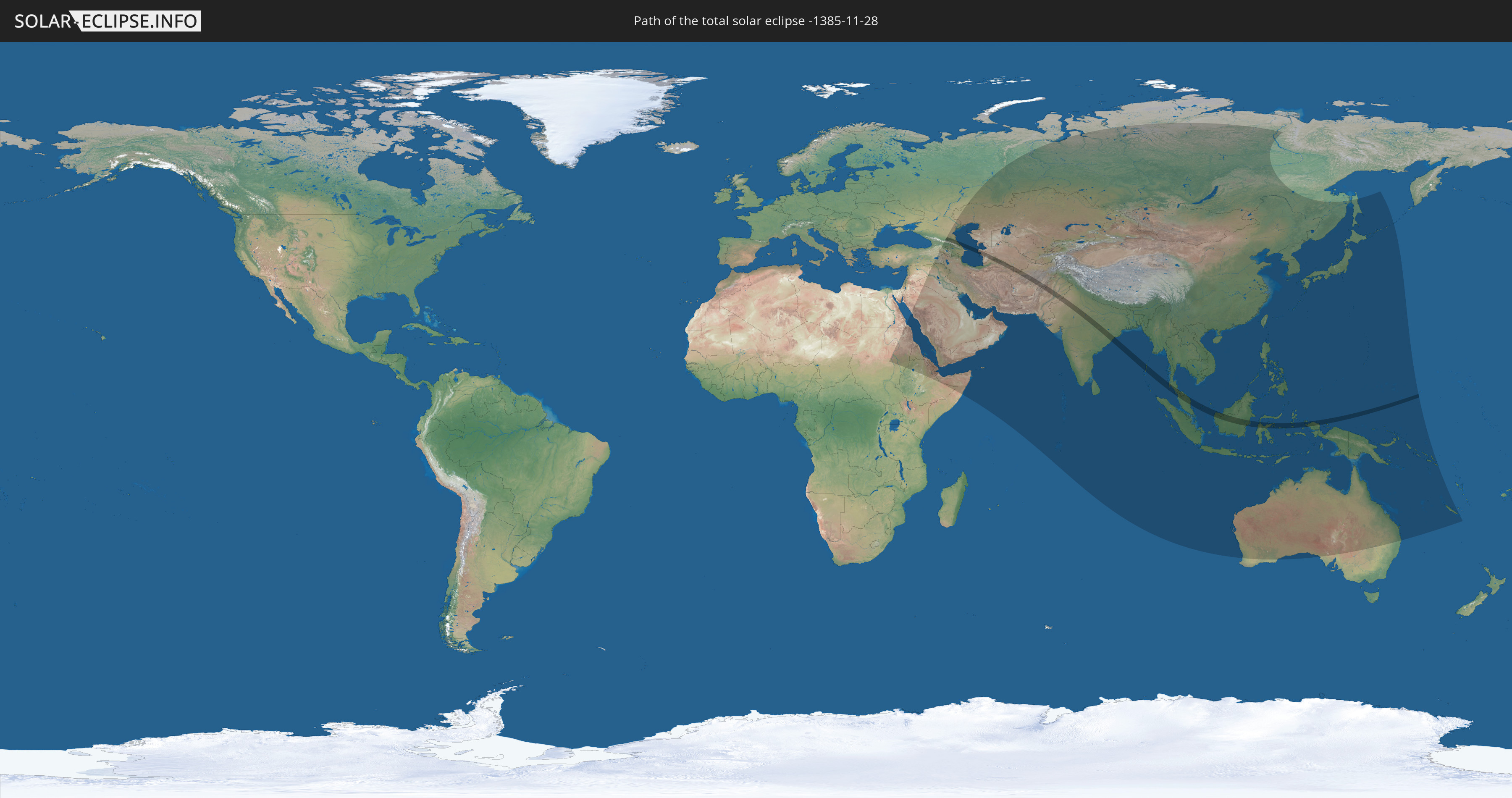
Die Sonnenfinsternis am 11/28/-1385 kann man in 64 Ländern als partielle Sonnenfinsternis beobachten.
Der Finsternispfad verläuft durch 12 Länder. Nur in diesen Ländern ist sie als total Sonnenfinsternis zu sehen.
In den folgenden Ländern ist die Sonnenfinsternis total zu sehen
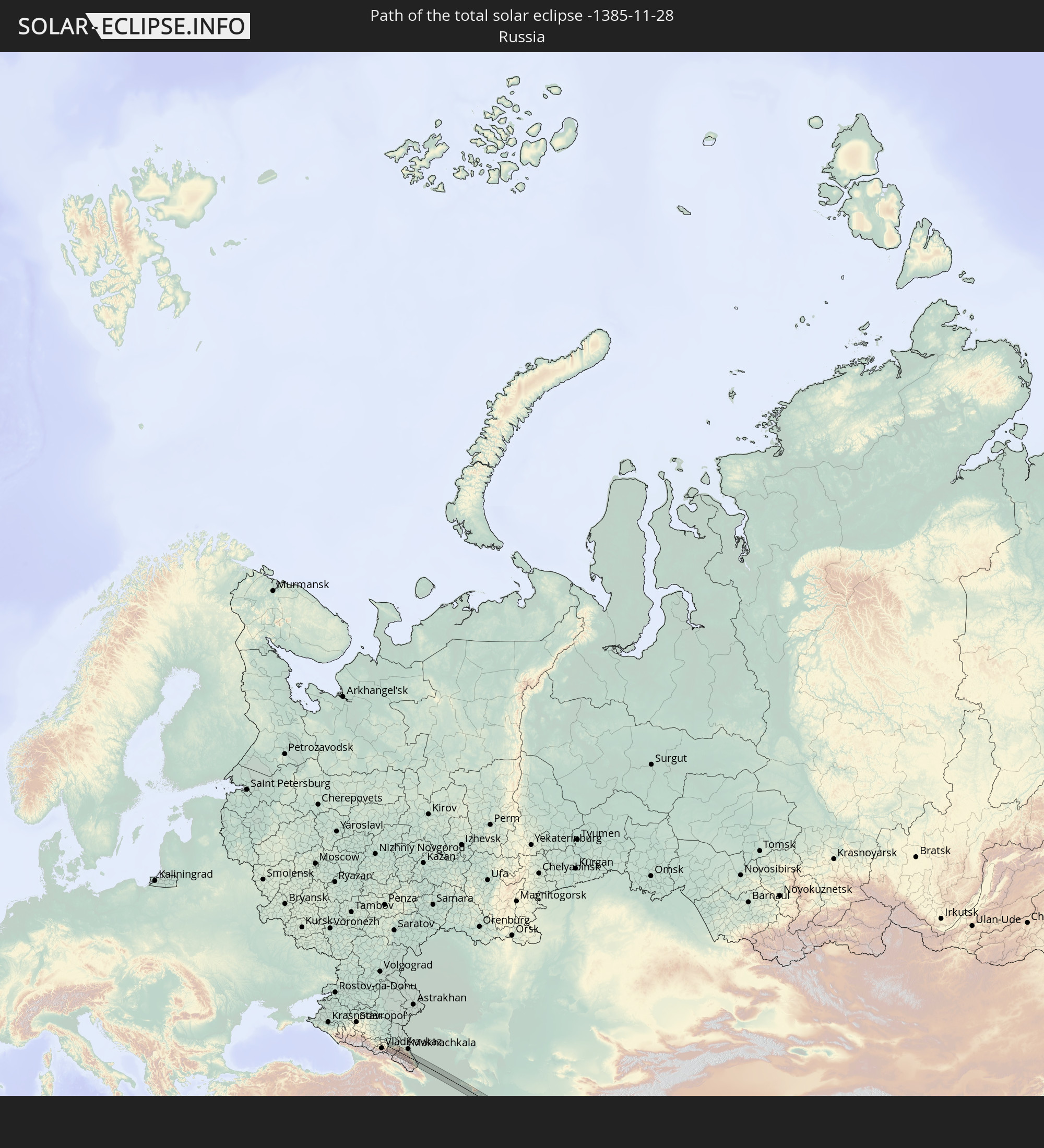 Russia
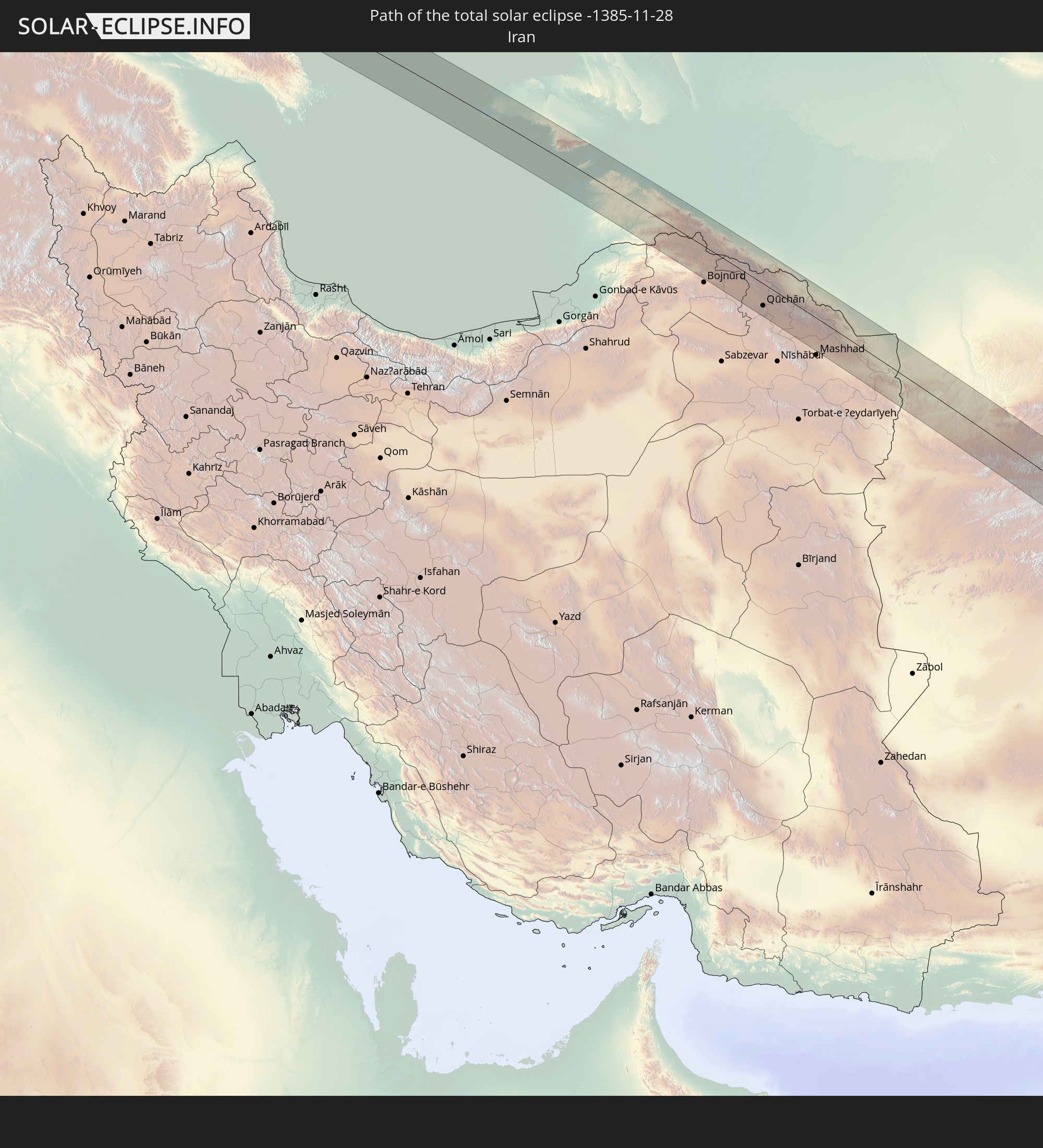 Iran
Iran
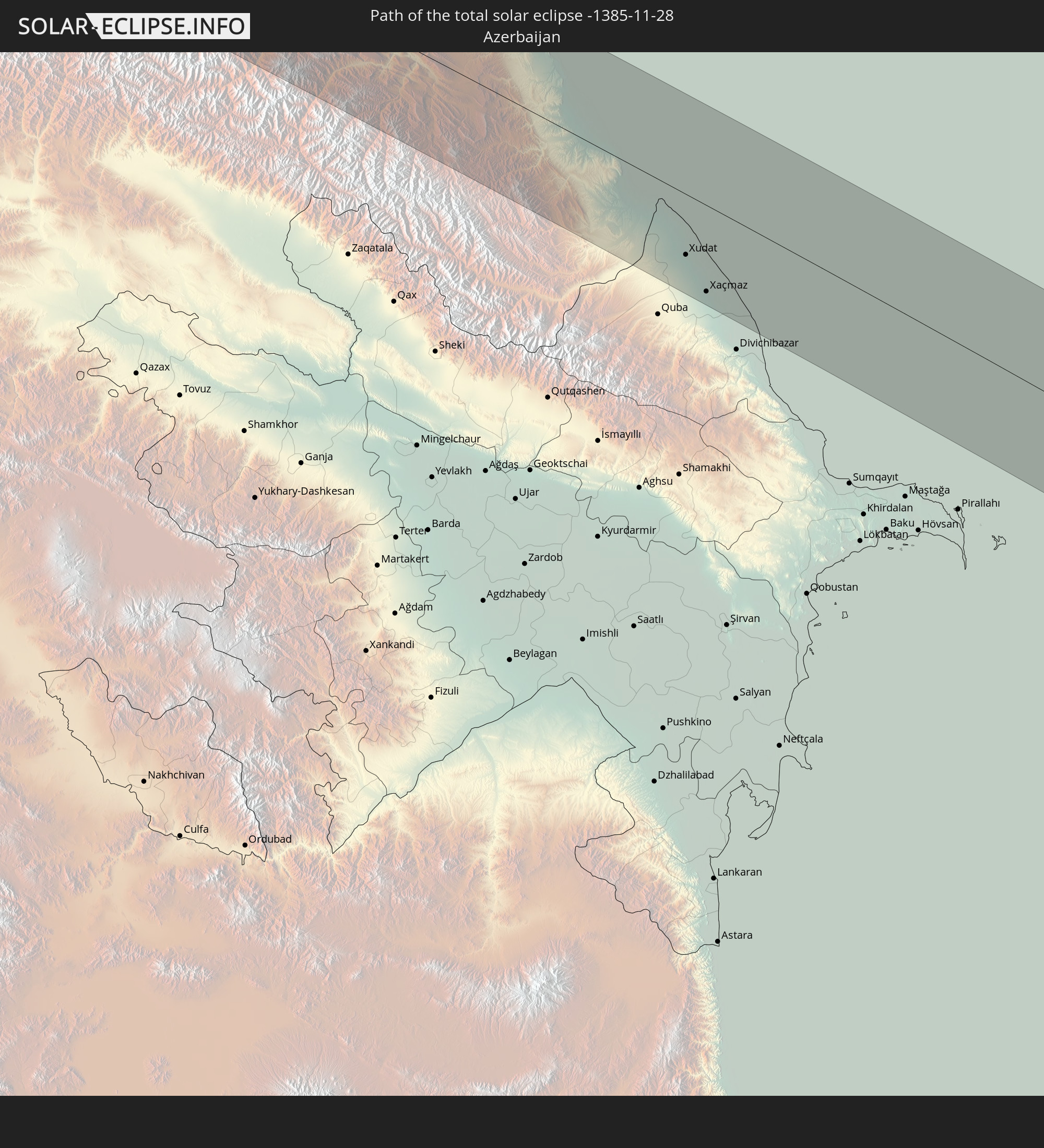 Azerbaijan
 Turkmenistan
 Afghanistan
 Pakistan
 India
India
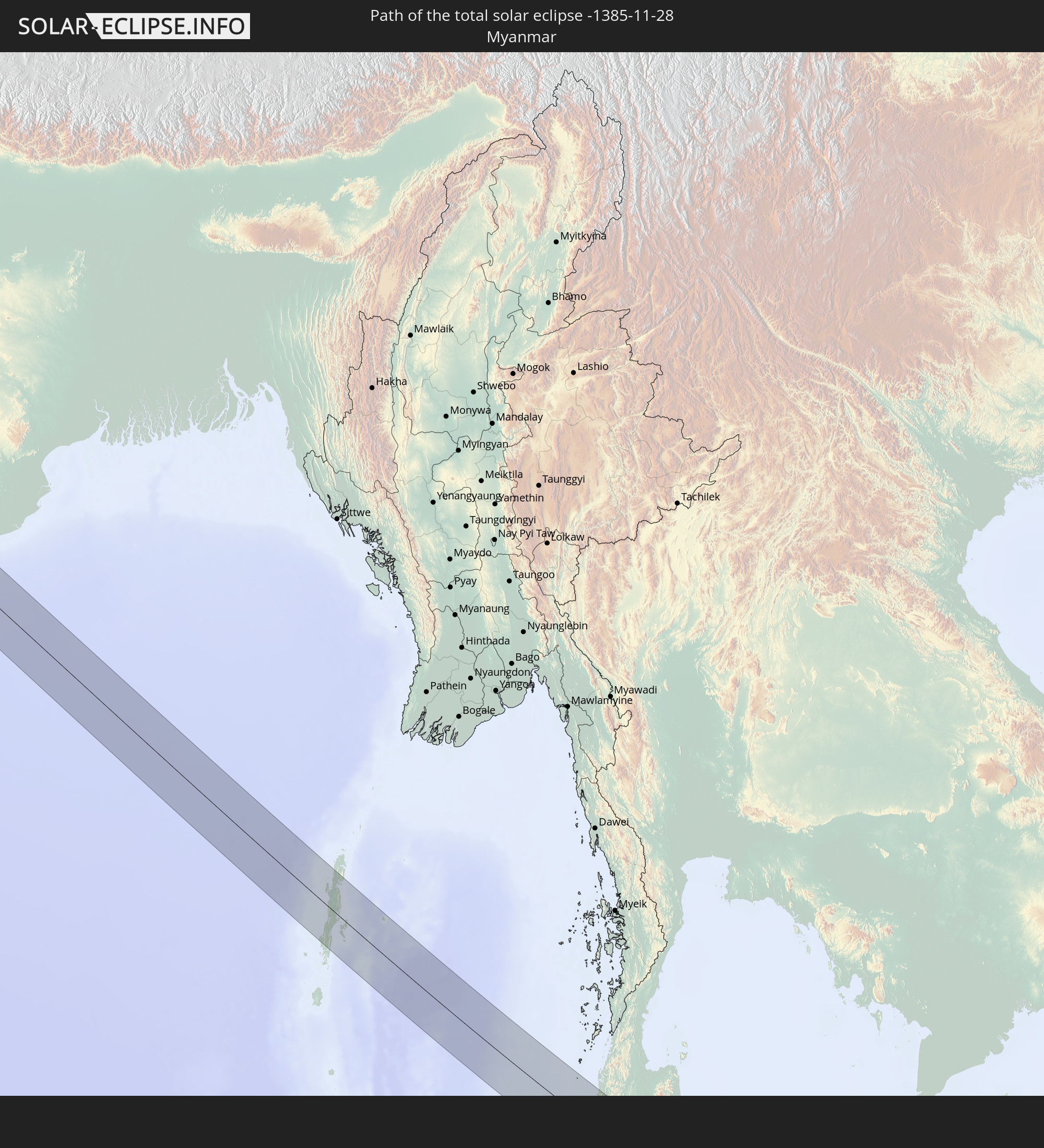 Myanmar
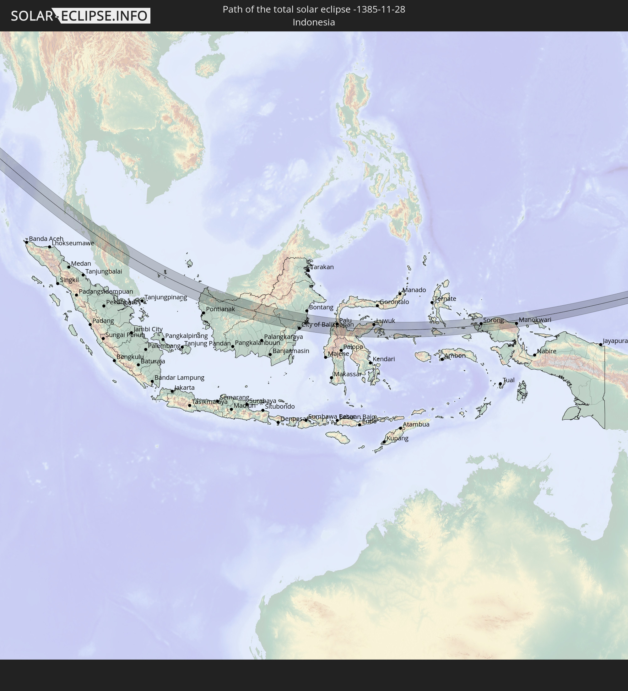 Indonesia
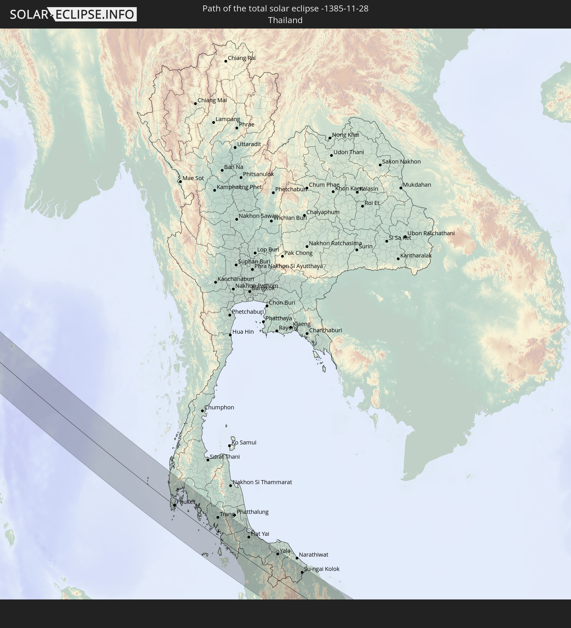 Thailand
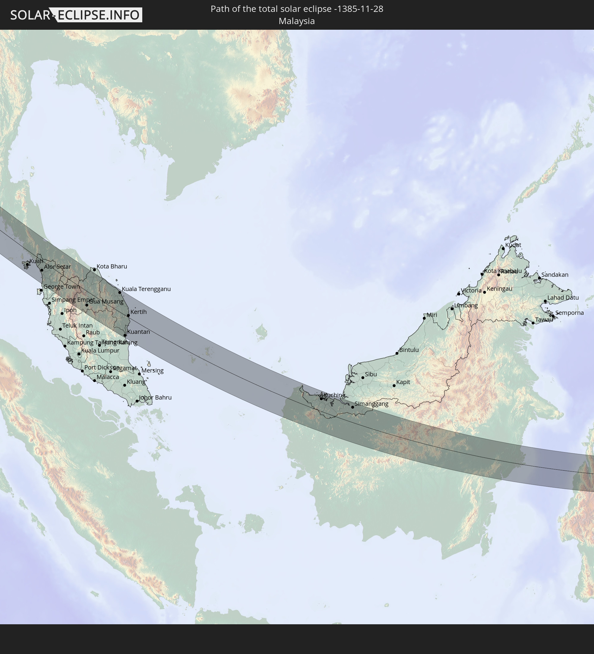 Malaysia
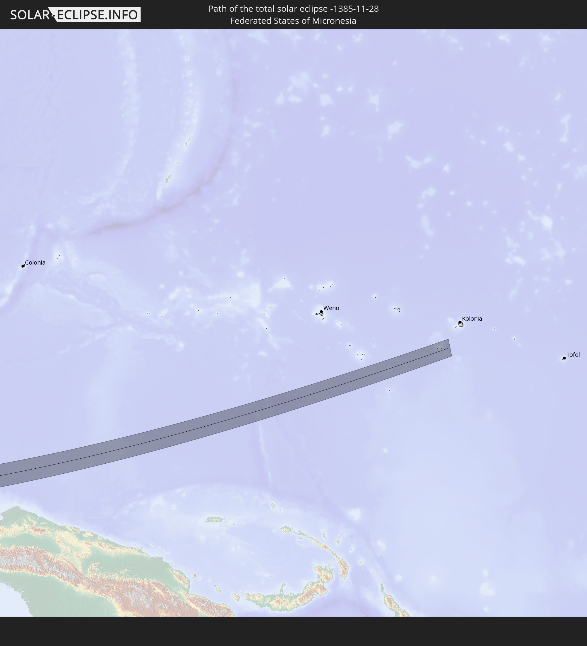 Federated States of Micronesia
In den folgenden Ländern ist die Sonnenfinsternis partiell zu sehen
 Russia
 Sudan
Sudan
 Egypt
Egypt
 Turkey
 Ethiopia
 Saudi Arabia
 Syria
Syria
 Eritrea
 Iraq
Iraq
 Georgia
 Somalia
 Djibouti
 Yemen
Yemen
 Armenia
 Iran
Iran
 Azerbaijan
 Kazakhstan
 Kuwait
 Bahrain
 Qatar
Qatar
 United Arab Emirates
 Oman
Oman
 Turkmenistan
 Uzbekistan
 Afghanistan
 Pakistan
 Tajikistan
 India
India
 Kyrgyzstan
 British Indian Ocean Territory
 Maldives
 China
China
 Sri Lanka
 Nepal
Nepal
 Mongolia
 Bangladesh
 Bhutan
 Myanmar
 Indonesia
 Cocos Islands
 Thailand
 Malaysia
 Laos
Laos
 Vietnam
 Cambodia
 Singapore
 Christmas Island
 Australia
 Macau
Macau
 Hong Kong
 Brunei
 Taiwan
 Philippines
 Japan
Japan
 East Timor
 North Korea
 South Korea
 Palau
Palau
 Federated States of Micronesia
 Papua New Guinea
 Guam
Guam
 Northern Mariana Islands
 Solomon Islands
 New Caledonia
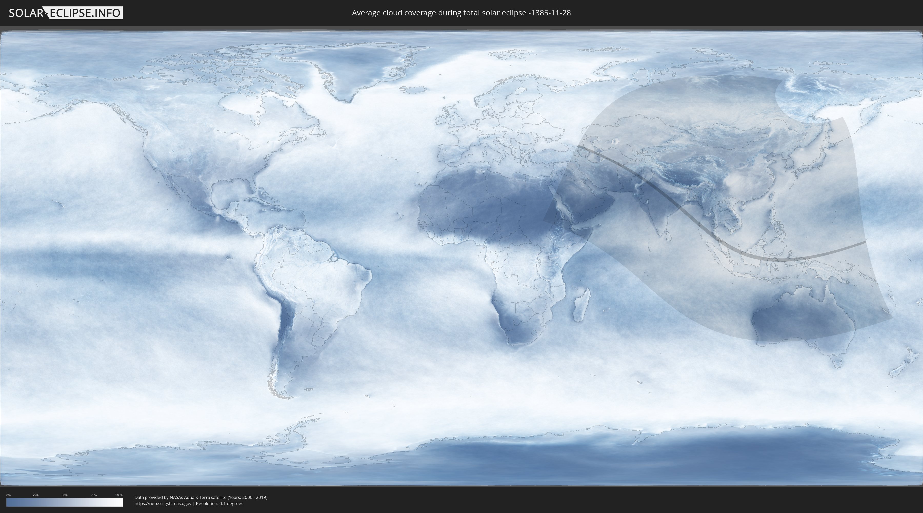
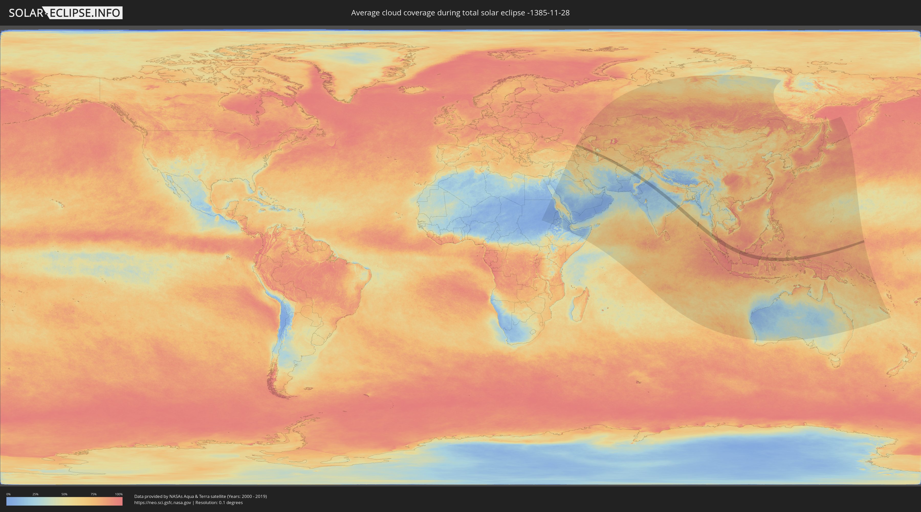
How will be the weather during the total solar eclipse on 11/28/-1385?
Where is the best place to see the total solar eclipse of 11/28/-1385?
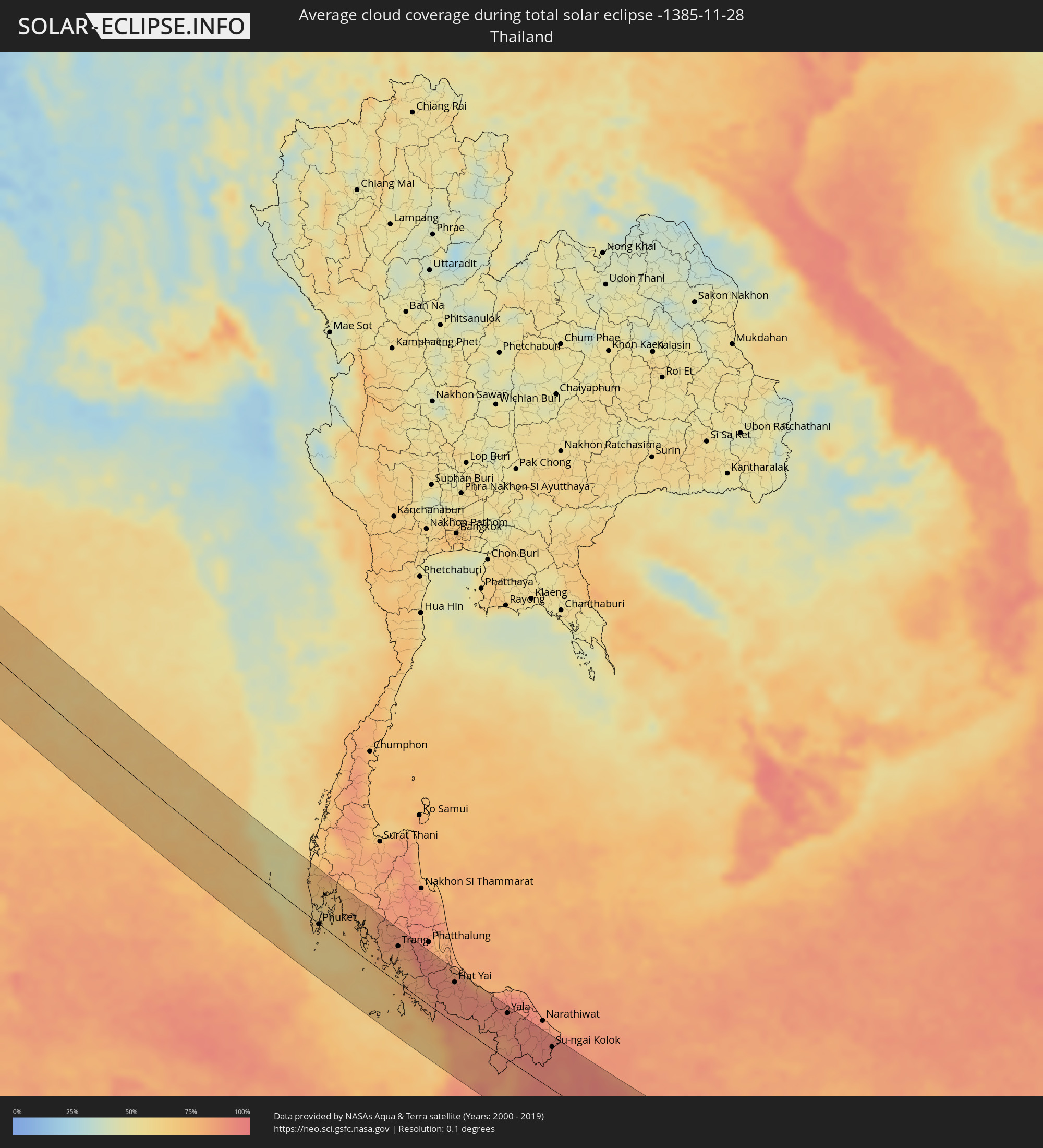
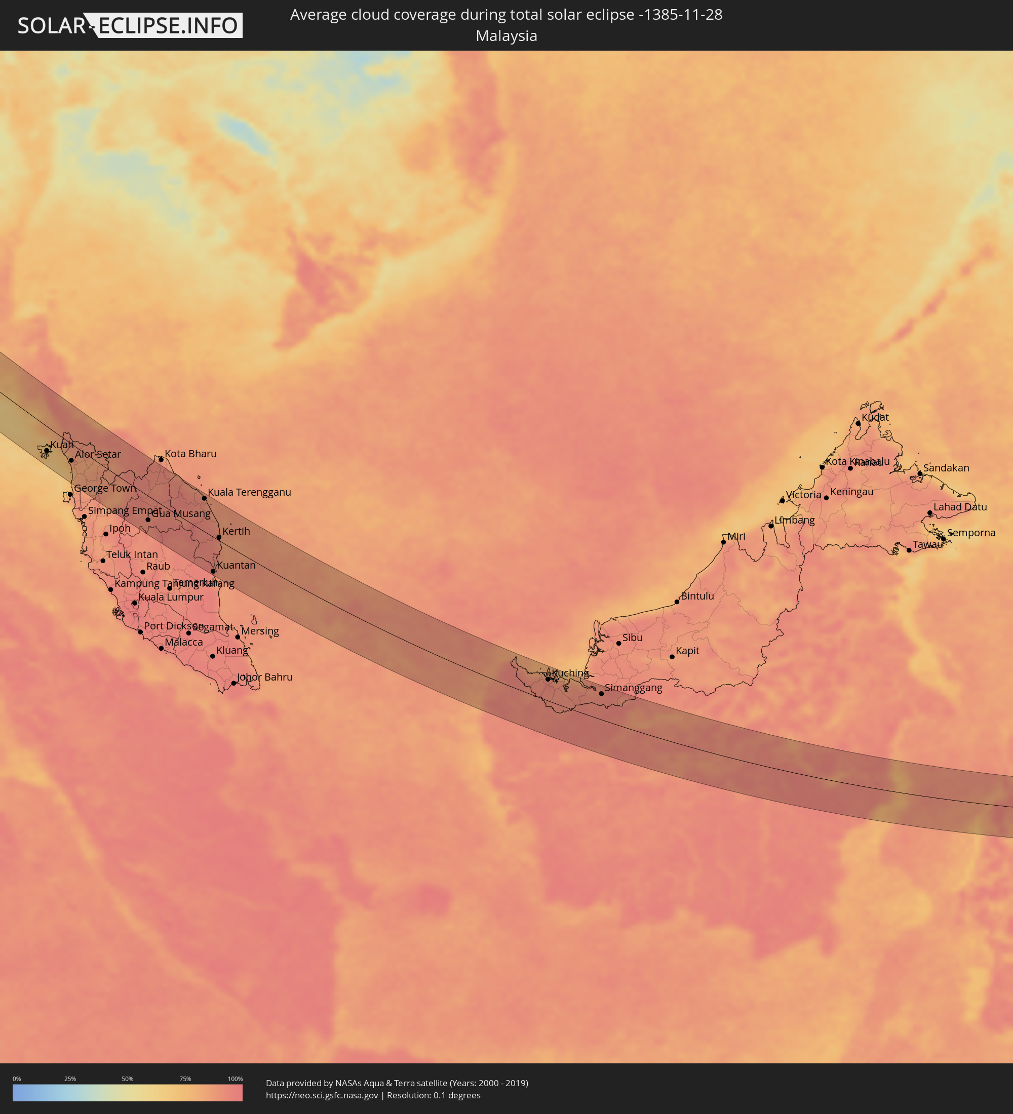
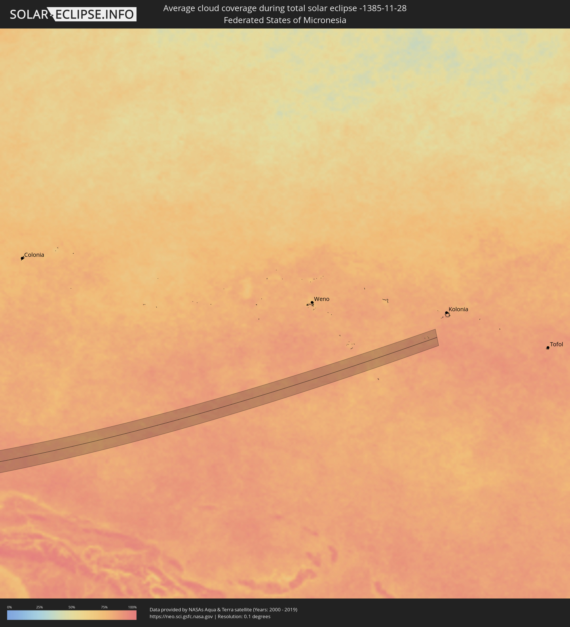
The following maps show the average cloud coverage for the day of the total solar eclipse.
With the help of these maps, it is possible to find the place along the eclipse path, which has the best
chance of a cloudless sky.
Nevertheless, you should consider local circumstances and inform about the weather of your chosen
observation site.
The data is provided by NASAs satellites
AQUA and TERRA.
The cloud maps are averaged over a period of 19 years (2000 - 2019).
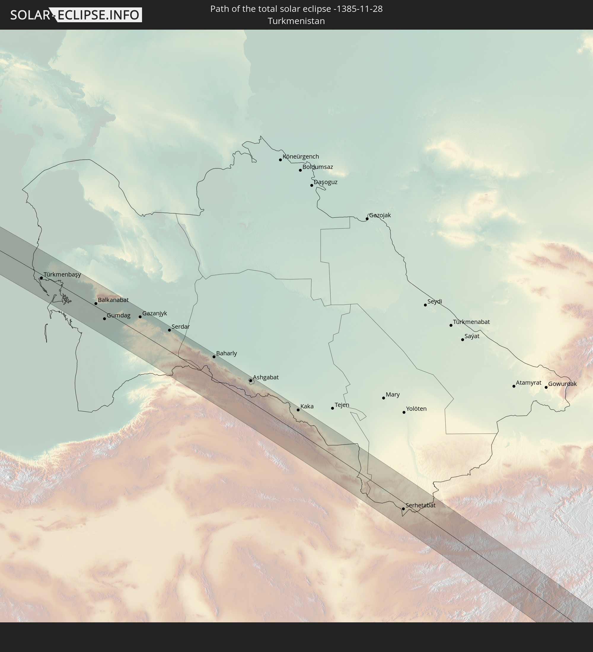
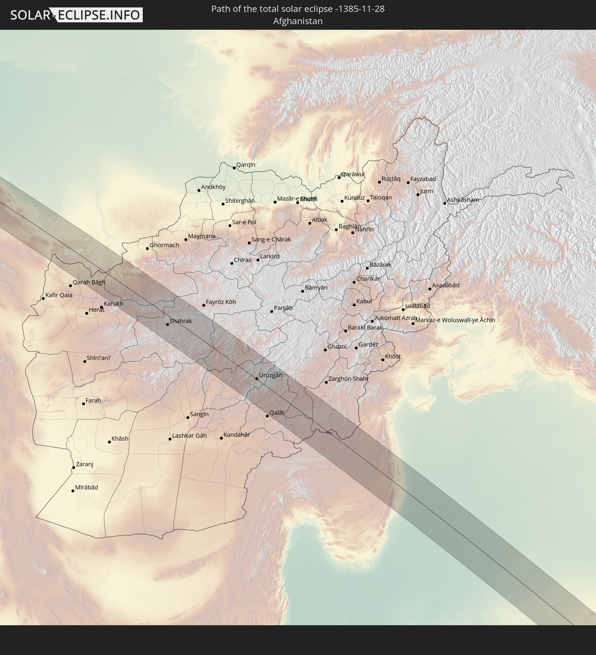
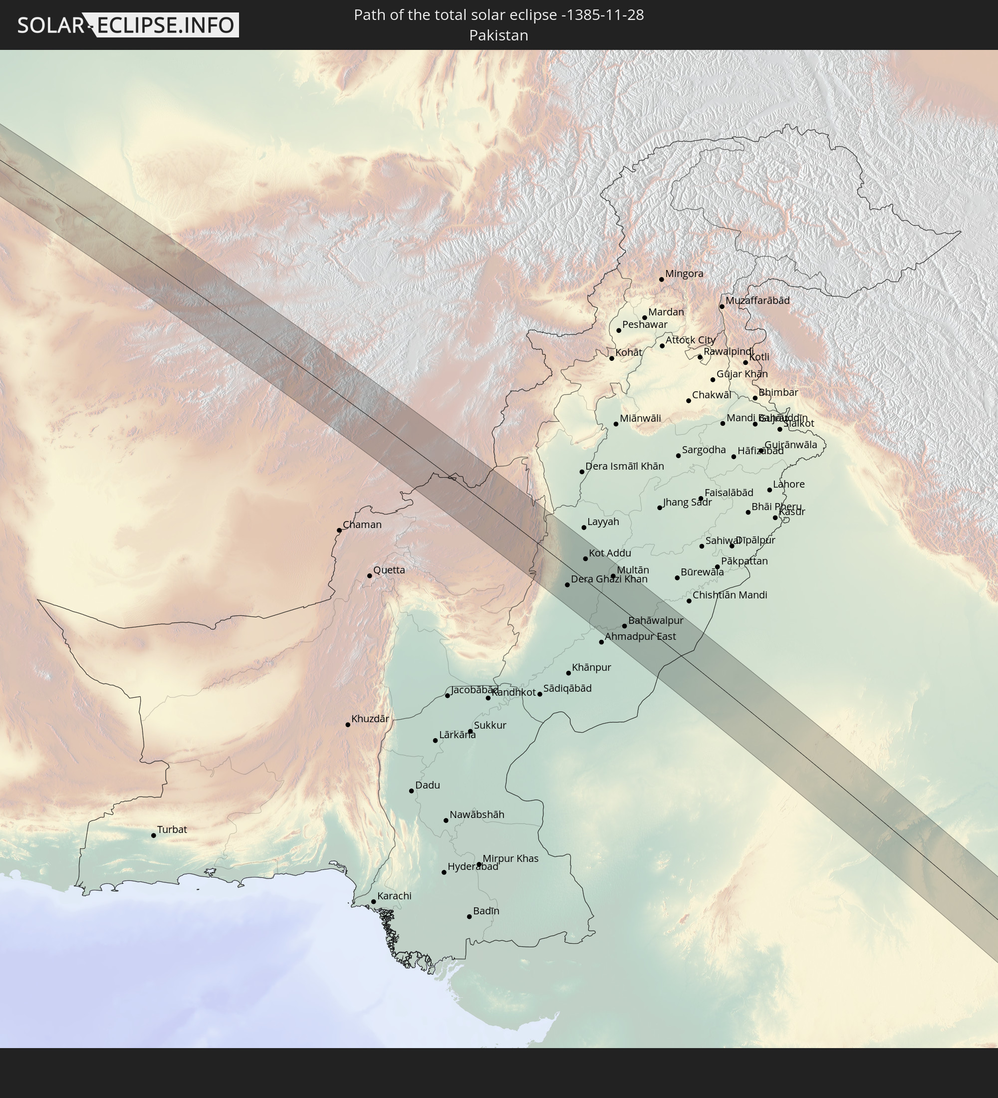
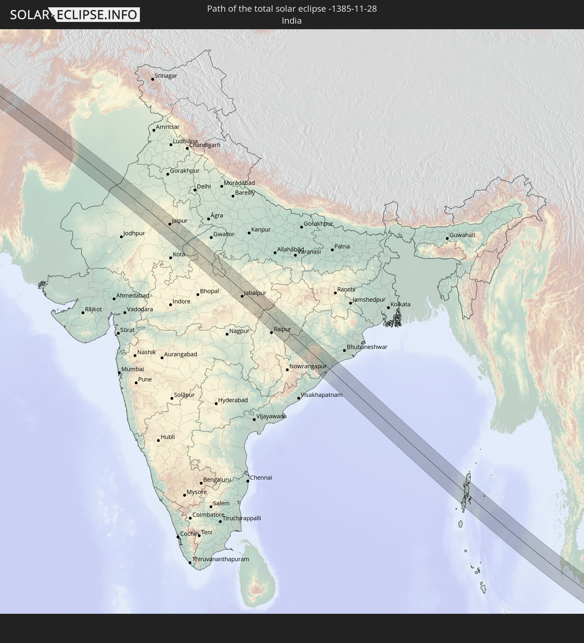
Detailed country maps
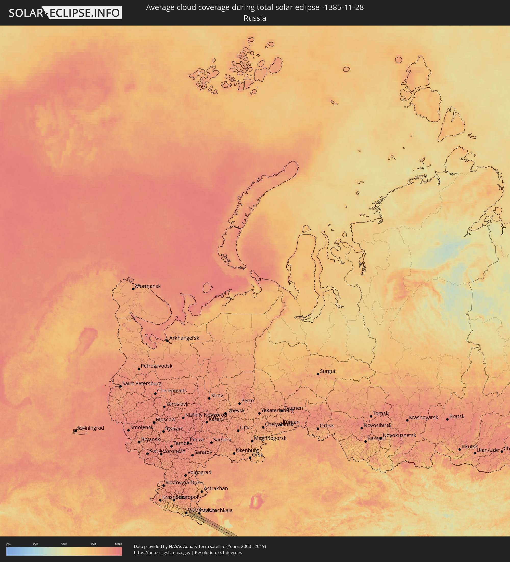 Russia
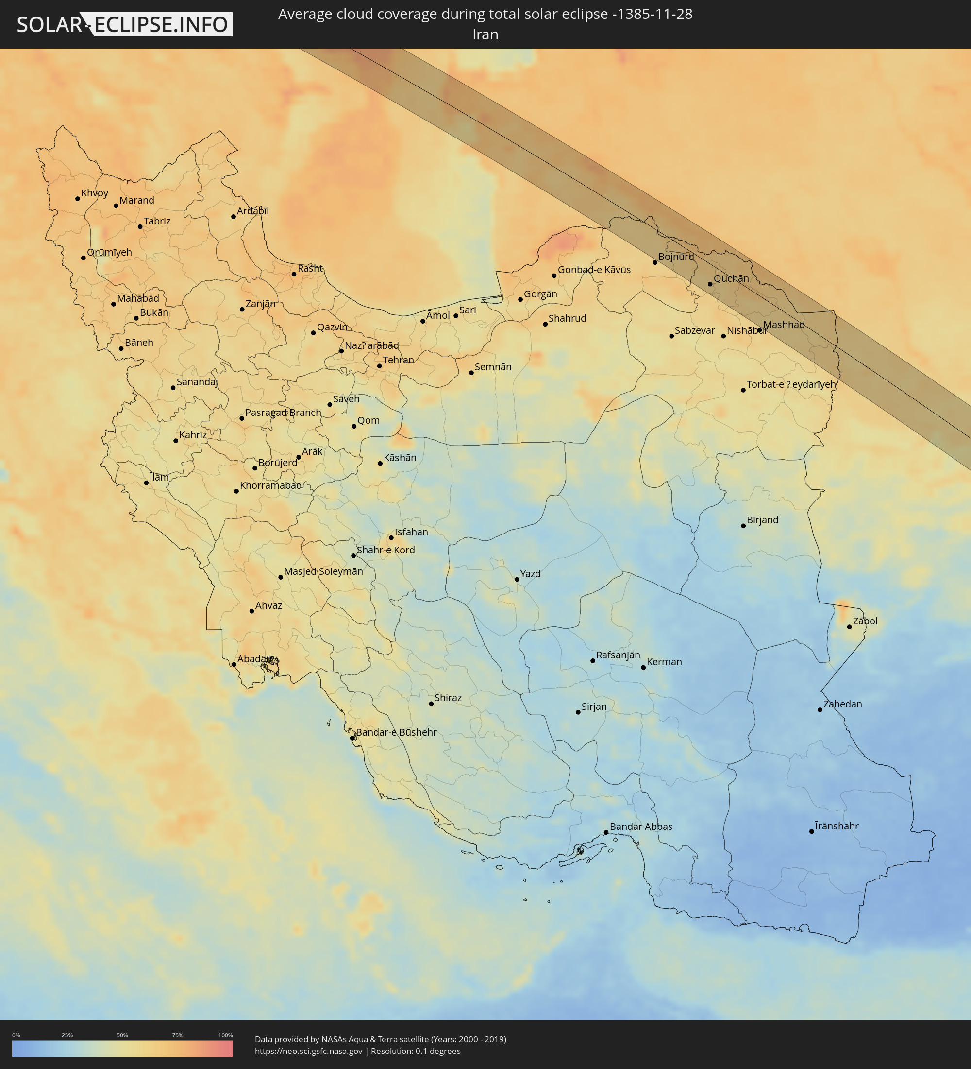 Iran
Iran
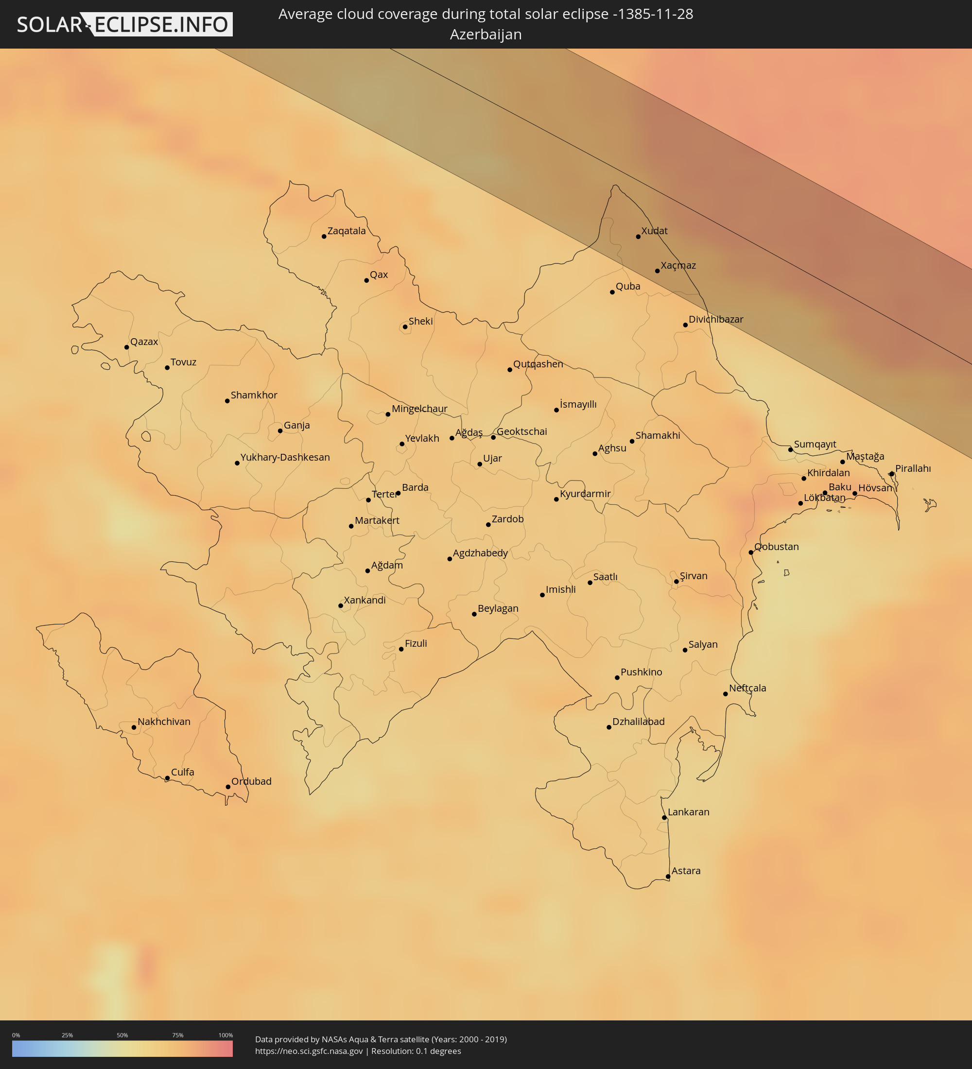 Azerbaijan
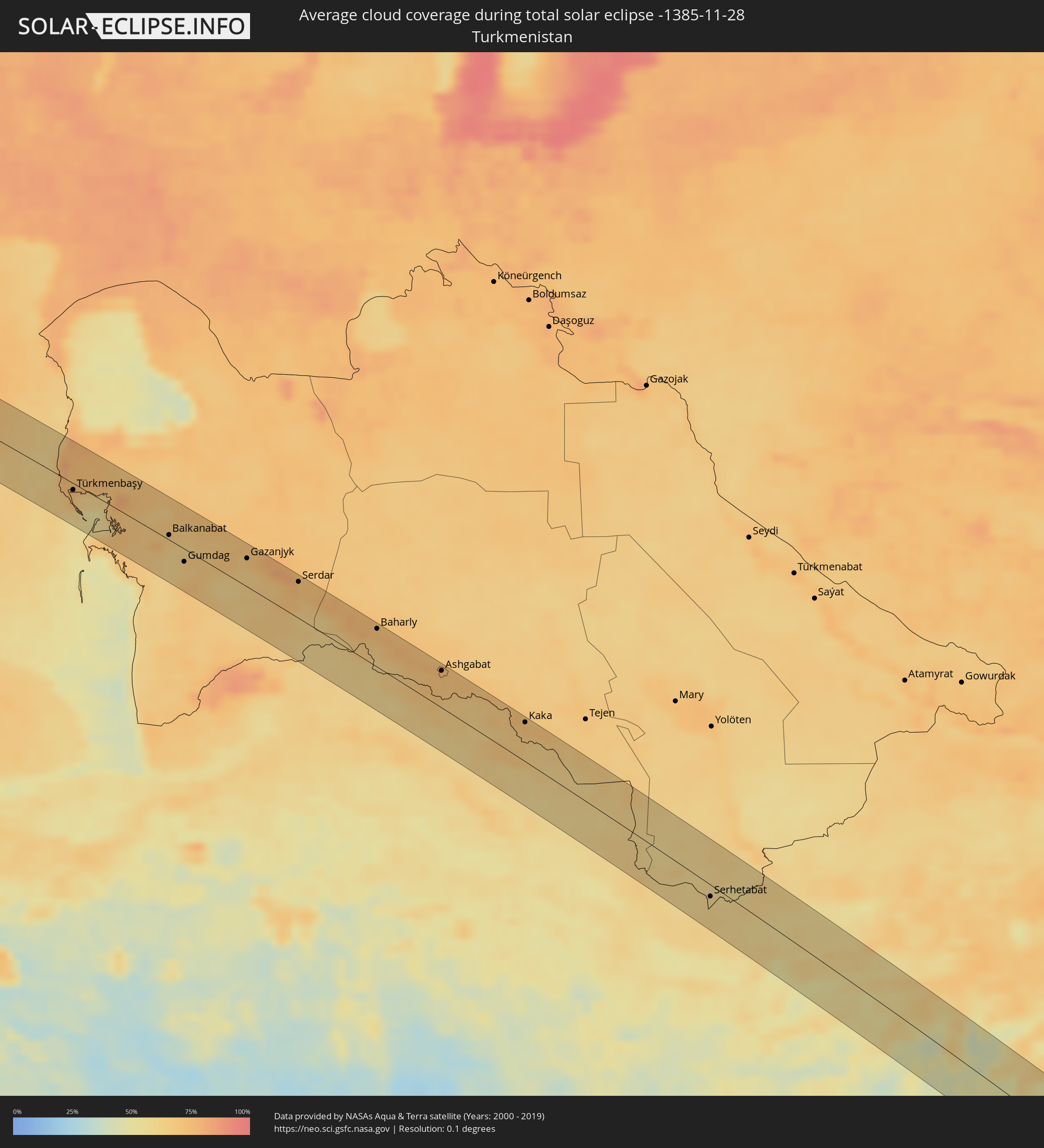 Turkmenistan
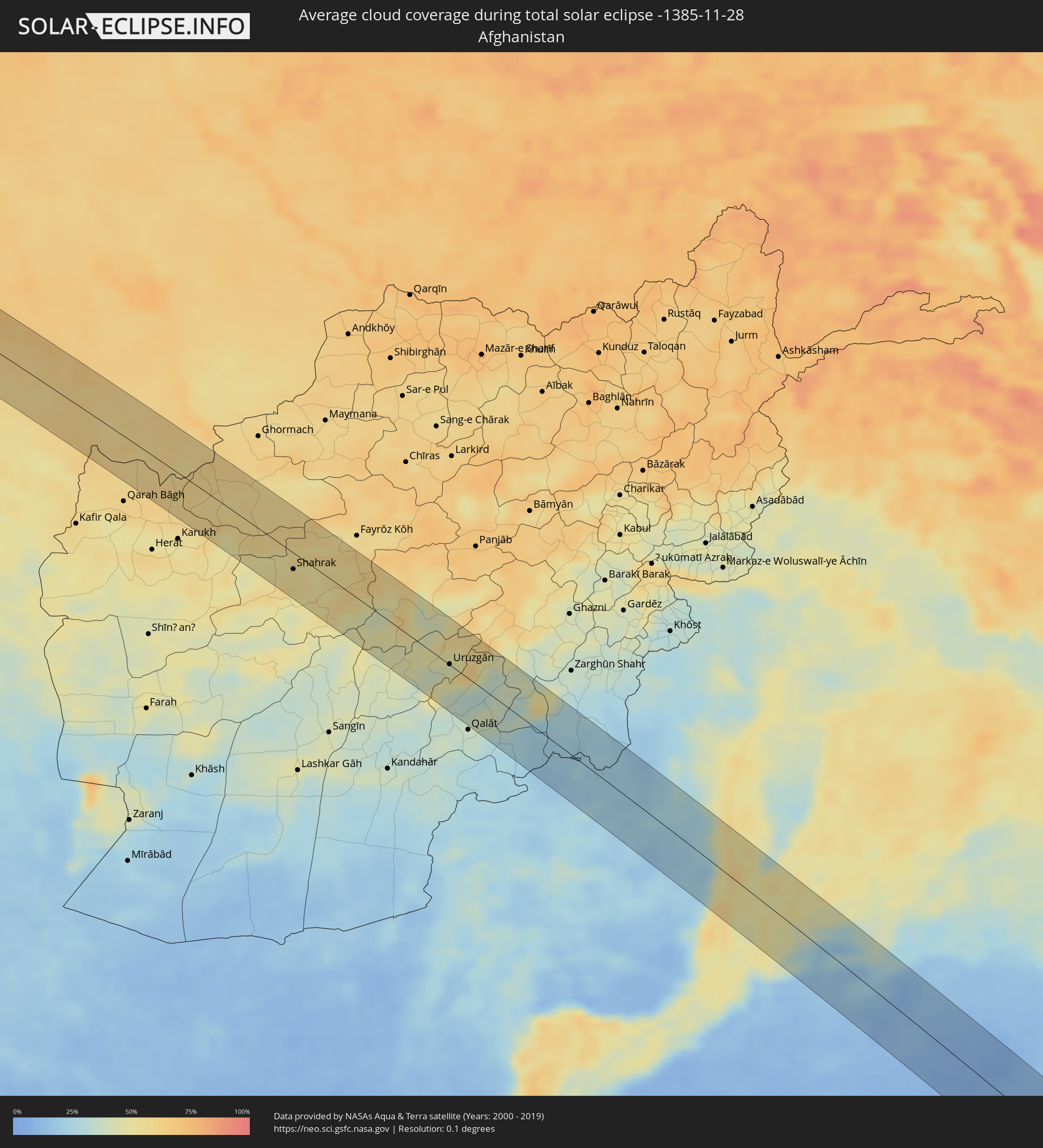 Afghanistan
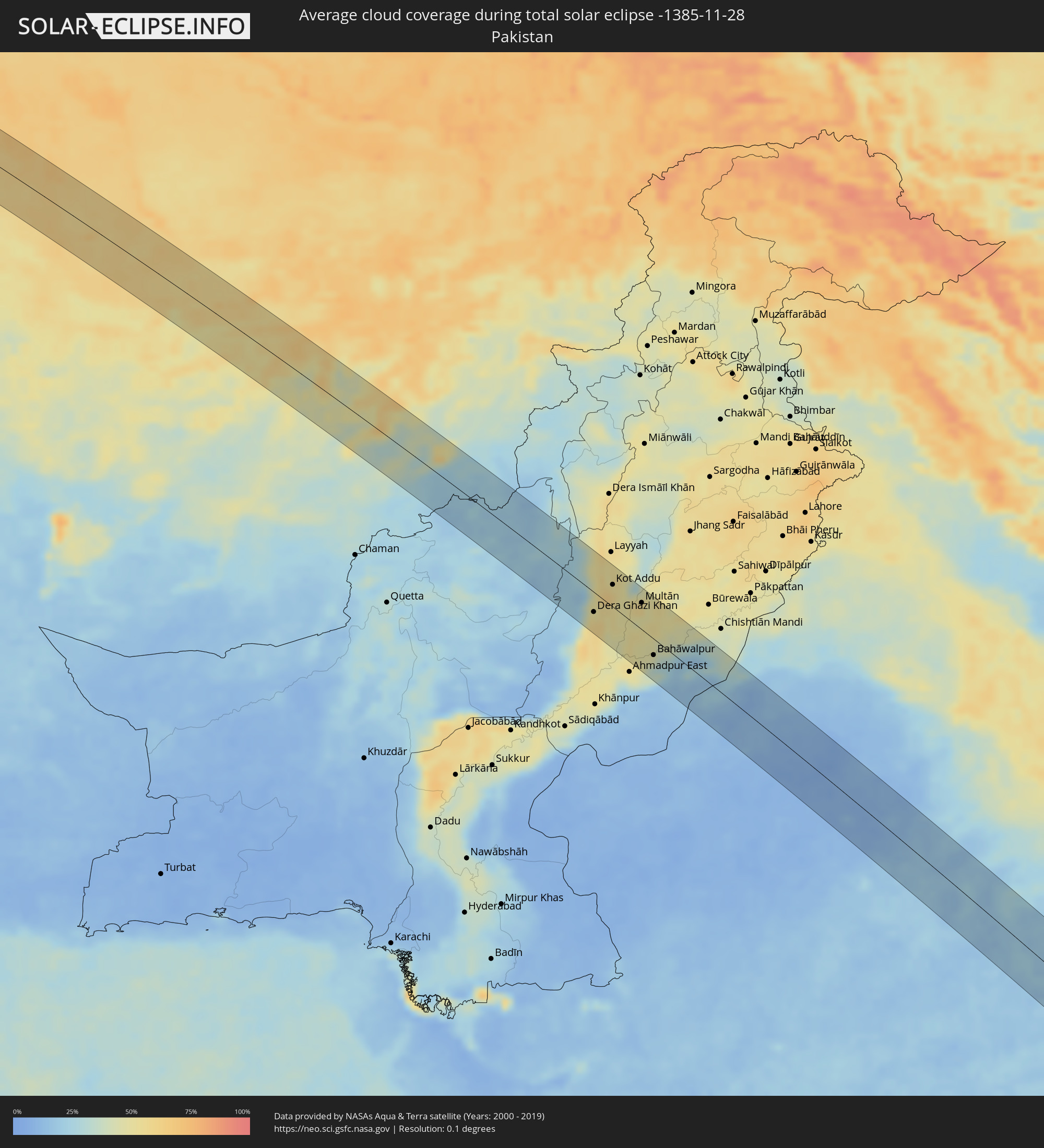 Pakistan
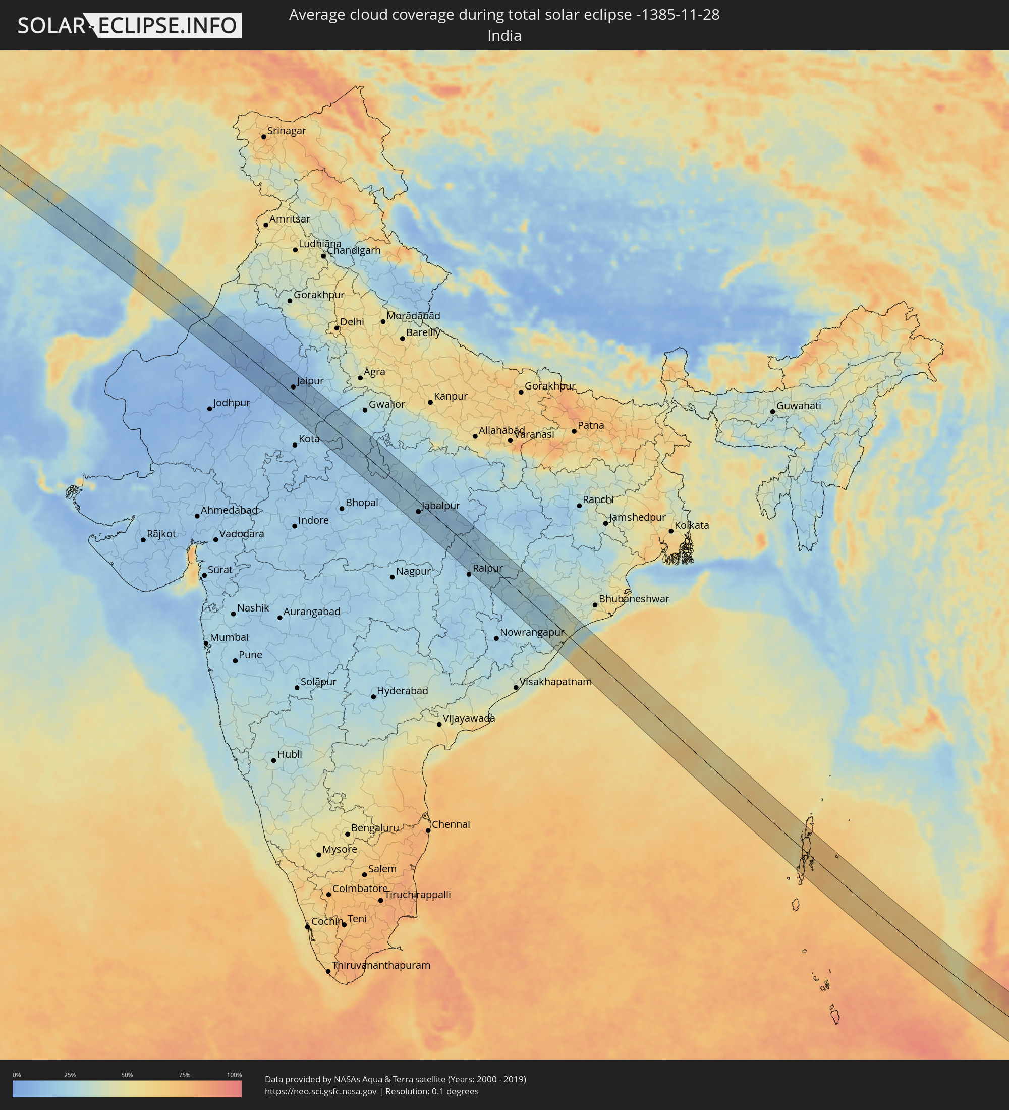 India
India
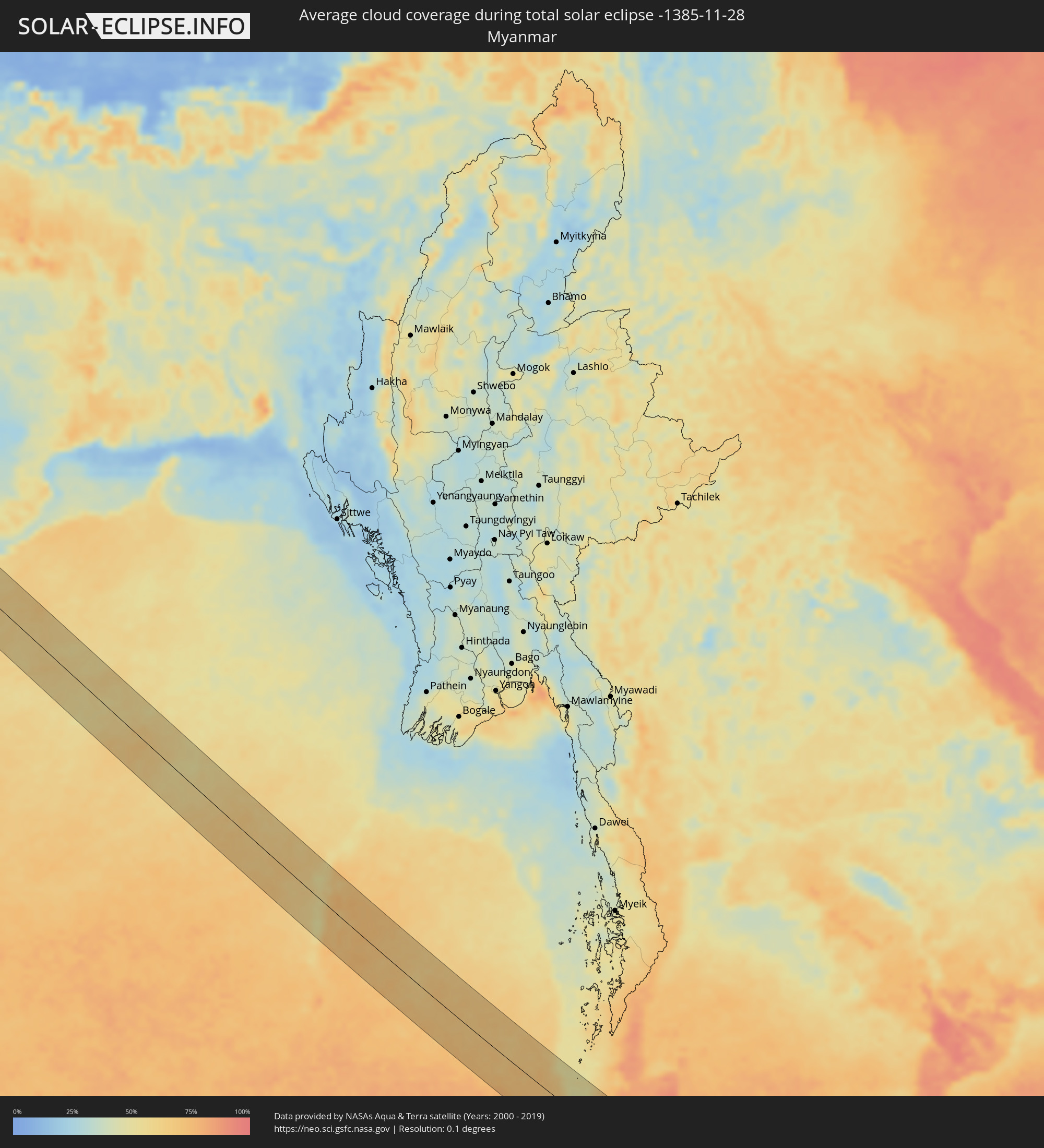 Myanmar
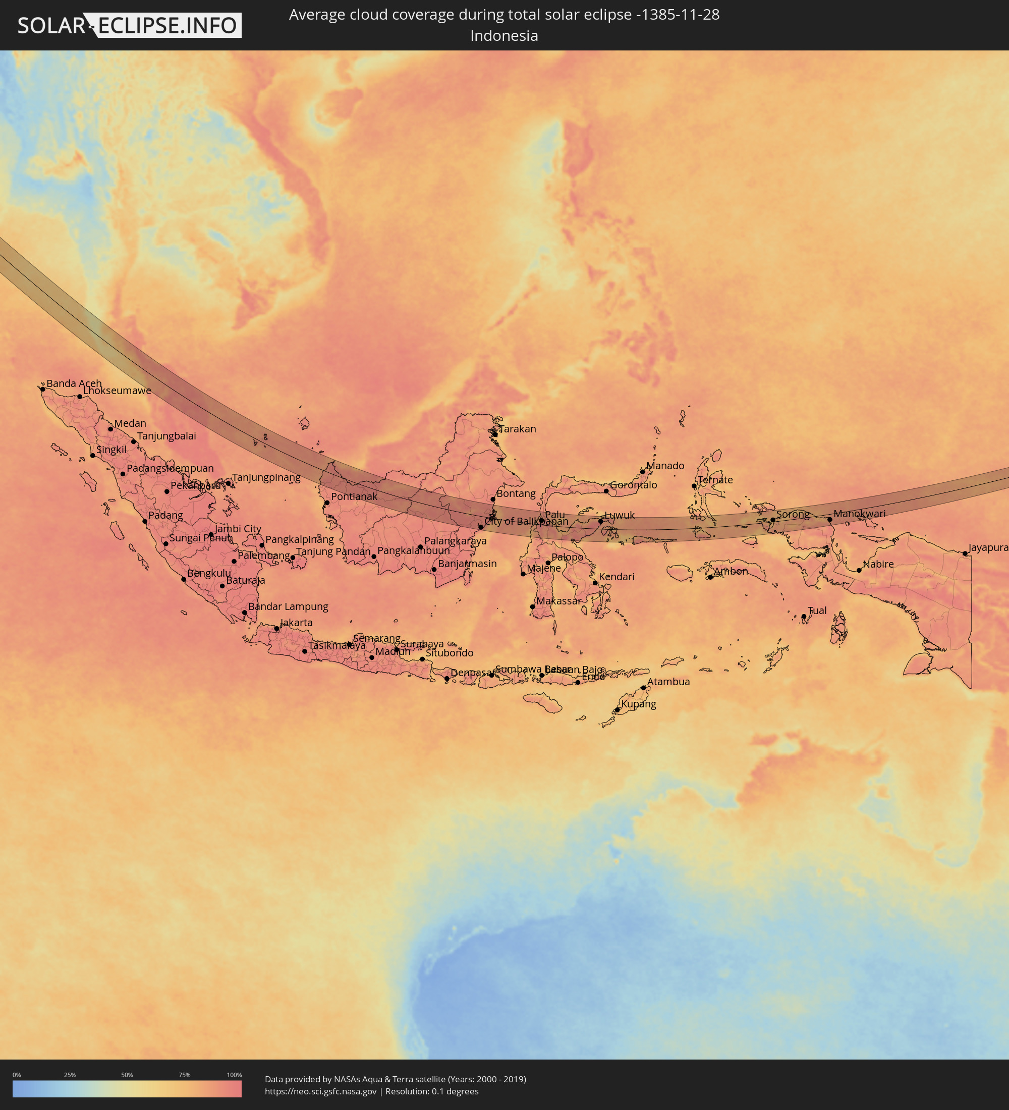 Indonesia
 Thailand
 Malaysia
 Federated States of Micronesia
Cities inside the path of the eclipse
The following table shows all locations with a population of more than 5,000 inside the eclipse path. Cities which have more than 100,000 inhabitants are marked bold. A click at the locations opens a detailed map.
| City | Type | Eclipse duration | Local time of max. eclipse | Distance to central line | Ø Cloud coverage |
|
Achkhoy-Martan, Chechnya
|
total | - | 06:38:25 UTC+02:30 | 3 km | 74% |
|
Urus-Martan, Chechnya
|
total | - | 06:38:26 UTC+02:30 | 3 km | 74% |
|
Groznyy, Chechnya
|
total | - | 06:38:34 UTC+02:30 | 25 km | 80% |
|
Tolstoy-Yurt, Chechnya
|
total | - | 06:38:39 UTC+02:30 | 41 km | 80% |
|
Argun, Chechnya
|
total | - | 06:38:36 UTC+02:30 | 30 km | 79% |
|
Shali, Chechnya
|
total | - | 06:38:31 UTC+02:30 | 16 km | 74% |
|
Kurchaloy, Chechnya
|
total | - | 06:38:35 UTC+02:30 | 28 km | 75% |
|
Alleroy, Chechnya
|
total | - | 06:38:38 UTC+02:30 | 37 km | 73% |
|
Dylym, Dagestan
|
total | - | 06:38:39 UTC+02:30 | 36 km | 70% |
|
Chirkey, Dagestan
|
total | - | 06:38:40 UTC+02:30 | 38 km | 72% |
|
Buynaksk, Dagestan
|
total | - | 06:38:38 UTC+02:30 | 29 km | 66% |
|
Levashi, Dagestan
|
total | - | 06:38:29 UTC+02:30 | 1 km | 62% |
|
Karabudakhkent, Dagestan
|
total | - | 06:38:41 UTC+02:30 | 36 km | 70% |
|
Sergokala, Dagestan
|
total | - | 06:38:35 UTC+02:30 | 14 km | 67% |
|
Izberbash, Dagestan
|
total | - | 06:38:41 UTC+02:30 | 34 km | 70% |
|
Kayakent, Dagestan
|
total | - | 06:38:36 UTC+02:30 | 17 km | 72% |
|
Mamedkala, Dagestan
|
total | - | 06:38:33 UTC+02:30 | 4 km | 73% |
|
Kasumkent, Dagestan
|
total | - | 06:38:20 UTC+02:30 | 43 km | 64% |
|
Derbent, Dagestan
|
total | - | 06:38:33 UTC+02:30 | 1 km | 73% |
|
Belidzhi, Dagestan
|
total | - | 06:38:30 UTC+02:30 | 12 km | 74% |
|
Xudat, Xaçmaz
|
total | - | 07:27:34 UTC+03:19 | 27 km | 74% |
|
Xaçmaz, Xaçmaz
|
total | - | 07:27:32 UTC+03:19 | 38 km | 74% |
|
Türkmenbaşy, Balkan
|
total | - | 08:02:27 UTC+03:53 | 7 km | 65% |
|
Balkanabat, Balkan
|
total | - | 08:02:50 UTC+03:53 | 5 km | 65% |
|
Gumdag, Balkan
|
total | - | 08:02:49 UTC+03:53 | 14 km | 65% |
|
Gazanjyk, Balkan
|
total | - | 08:03:14 UTC+03:53 | 31 km | 64% |
|
Serdar, Balkan
|
total | - | 08:03:30 UTC+03:53 | 40 km | 72% |
|
Baharly, Ahal
|
total | - | 08:03:55 UTC+03:53 | 42 km | 72% |
|
Shīrvān, Khorāsān-e Shomālī
|
total | - | 07:36:06 UTC+03:25 | 33 km | 60% |
|
Abadan, Ahal
|
total | - | 08:04:12 UTC+03:53 | 42 km | 74% |
|
Ashgabat, Ahal
|
total | - | 08:04:17 UTC+03:53 | 41 km | 73% |
|
Qūchān, Razavi Khorasan
|
total | - | 07:36:21 UTC+03:25 | 33 km | 59% |
|
Annau, Ahal
|
total | - | 08:04:20 UTC+03:53 | 41 km | 69% |
|
Chenārān, Razavi Khorasan
|
total | - | 07:36:36 UTC+03:25 | 46 km | 57% |
|
Kaka, Ahal
|
total | - | 08:04:49 UTC+03:53 | 43 km | 68% |
|
Sarakhs, Razavi Khorasan
|
total | - | 07:37:47 UTC+03:25 | 44 km | 64% |
|
Serhetabat, Mary
|
total | - | 08:06:11 UTC+03:53 | 13 km | 60% |
|
Qala i Naw, Badghis
|
total | - | 08:13:10 UTC+04:00 | 1 km | 57% |
|
Shahrak, Ghowr
|
total | - | 08:13:57 UTC+04:00 | 18 km | 55% |
|
Nīlī, Daykundi
|
total | - | 08:15:21 UTC+04:00 | 45 km | 47% |
|
Uruzgān, Oruzgan
|
total | - | 08:15:46 UTC+04:00 | 1 km | 48% |
|
Zhob, Balochistān
|
total | - | 08:46:36 UTC+04:28 | 18 km | 18% |
|
Dera Ghazi Khan, Punjab
|
total | - | 08:47:59 UTC+04:28 | 26 km | 51% |
|
Taunsa, Punjab
|
total | - | 08:47:52 UTC+04:28 | 31 km | 51% |
|
Kot Addu, Punjab
|
total | - | 08:48:13 UTC+04:28 | 29 km | 53% |
|
Shahr Sultān, Punjab
|
total | - | 08:48:30 UTC+04:28 | 46 km | 46% |
|
Khāngarh, Punjab
|
total | - | 08:48:33 UTC+04:28 | 7 km | 50% |
|
Muzaffargarh, Punjab
|
total | - | 08:48:32 UTC+04:28 | 8 km | 48% |
|
Jalālpur Pīrwāla, Punjab
|
total | - | 08:48:43 UTC+04:28 | 40 km | 49% |
|
Shujāābād, Punjab
|
total | - | 08:48:41 UTC+04:28 | 3 km | 50% |
|
Multān, Punjab
|
total | - | 08:48:48 UTC+04:28 | 36 km | 55% |
|
Lodhrān, Punjab
|
total | - | 08:49:07 UTC+04:28 | 12 km | 47% |
|
Qādirpur Rān, Punjab
|
total | - | 08:48:58 UTC+04:28 | 56 km | 49% |
|
Bahāwalpur, Punjab
|
total | - | 08:49:13 UTC+04:28 | 22 km | 40% |
|
Dunyāpur, Punjab
|
total | - | 08:49:09 UTC+04:28 | 16 km | 52% |
|
Yazman, Punjab
|
total | - | 08:49:22 UTC+04:28 | 42 km | 36% |
|
Dhanot, Punjab
|
total | - | 08:49:14 UTC+04:28 | 2 km | 41% |
|
Kohror Pakka, Punjab
|
total | - | 08:49:24 UTC+04:28 | 12 km | 43% |
|
Mailsi, Punjab
|
total | - | 08:49:37 UTC+04:28 | 43 km | 45% |
|
Khairpur, Punjab
|
total | - | 08:49:44 UTC+04:28 | 27 km | 32% |
|
Fort Abbās, Punjab
|
total | - | 08:50:30 UTC+04:28 | 31 km | 28% |
|
Bīkaner, Rajasthan
|
total | - | 09:44:22 UTC+05:21 | 43 km | 11% |
|
Sūjāngarh, Rajasthan
|
total | - | 09:45:48 UTC+05:21 | 2 km | 7% |
|
Makrāna, Rajasthan
|
total | - | 09:46:22 UTC+05:21 | 39 km | 9% |
|
Fatehpur, Rajasthan
|
total | - | 09:46:15 UTC+05:21 | 58 km | 7% |
|
Sīkar, Rajasthan
|
total | - | 09:46:37 UTC+05:21 | 36 km | 10% |
|
Jaipur, Rajasthan
|
total | - | 09:47:42 UTC+05:21 | 18 km | 13% |
|
Tonk, Rajasthan
|
total | - | 09:48:03 UTC+05:21 | 46 km | 18% |
|
Sawāi Mādhopur, Rajasthan
|
total | - | 09:48:49 UTC+05:21 | 23 km | 18% |
|
Gangāpur, Rajasthan
|
total | - | 09:49:03 UTC+05:21 | 39 km | 19% |
|
Shivpuri, Madhya Pradesh
|
total | - | 09:50:49 UTC+05:21 | 12 km | 18% |
|
Lalitpur, Uttar Pradesh
|
total | - | 09:52:15 UTC+05:21 | 0 km | 19% |
|
Saugor, Madhya Pradesh
|
total | - | 09:53:14 UTC+05:21 | 51 km | 17% |
|
Tīkamgarh, Madhya Pradesh
|
total | - | 09:52:47 UTC+05:21 | 31 km | 19% |
|
Damoh, Madhya Pradesh
|
total | - | 09:54:13 UTC+05:21 | 4 km | 20% |
|
Jabalpur, Madhya Pradesh
|
total | - | 09:55:24 UTC+05:21 | 26 km | 17% |
|
Murwāra, Madhya Pradesh
|
total | - | 09:55:34 UTC+05:21 | 60 km | 20% |
|
Bilāspur, Chhattisgarh
|
total | - | 09:59:30 UTC+05:21 | 34 km | 23% |
|
Balāngīr, Odisha
|
total | - | 10:02:47 UTC+05:21 | 13 km | 28% |
|
Brahmapur, Odisha
|
total | - | 10:06:15 UTC+05:21 | 10 km | 43% |
|
Port Blair, Andaman and Nicobar Islands
|
total | - | 10:30:59 UTC+05:21 | 69 km | 70% |
|
Patong, Phuket
|
total | - | 12:10:28 UTC+06:42 | 7 km | 68% |
|
Rawai, Phuket
|
total | - | 12:10:42 UTC+06:42 | 15 km | 64% |
|
Ban Chalong, Phuket
|
total | - | 12:10:39 UTC+06:42 | 8 km | 64% |
|
Ban Talat Nua, Phuket
|
total | - | 12:10:42 UTC+06:42 | 2 km | 67% |
|
Ban Ko Kaeo, Phuket
|
total | - | 12:10:39 UTC+06:42 | 4 km | 67% |
|
Phuket, Phuket
|
total | - | 12:10:43 UTC+06:42 | 0 km | 67% |
|
Phang Nga, Phangnga
|
total | - | 12:10:12 UTC+06:42 | 58 km | 72% |
|
Krabi, Krabi
|
total | - | 12:11:43 UTC+06:42 | 50 km | 78% |
|
Nuea Khlong, Krabi
|
total | - | 12:11:57 UTC+06:42 | 56 km | 78% |
|
Kantang, Trang
|
total | - | 12:14:16 UTC+06:42 | 30 km | 78% |
|
Trang, Trang
|
total | - | 12:14:17 UTC+06:42 | 50 km | 86% |
|
Huai Yot, Trang
|
total | - | 12:13:59 UTC+06:42 | 72 km | 88% |
|
Kuah, Kedah
|
total | - | 12:30:07 UTC+06:55 | 46 km | 71% |
|
Satun, Satun
|
total | - | 12:16:52 UTC+06:42 | 5 km | 80% |
|
Kangar, Perlis
|
total | - | 12:30:50 UTC+06:55 | 13 km | 77% |
|
Kuala Kedah, Kedah
|
total | - | 12:31:38 UTC+06:55 | 37 km | 76% |
|
Alor Setar, Kedah
|
total | - | 12:31:45 UTC+06:55 | 32 km | 81% |
|
Jitra, Kedah
|
total | - | 12:31:41 UTC+06:55 | 14 km | 86% |
|
Sadao, Songkhla
|
total | - | 12:17:46 UTC+06:42 | 20 km | 89% |
|
Hat Yai, Songkhla
|
total | - | 12:17:20 UTC+06:42 | 57 km | 91% |
|
Sungai Petani, Kedah
|
total | - | 12:32:48 UTC+06:55 | 67 km | 87% |
|
Bedong, Kedah
|
total | - | 12:32:44 UTC+06:55 | 58 km | 85% |
|
Betong, Yala
|
total | - | 12:20:46 UTC+06:42 | 19 km | 86% |
|
Yala, Yala
|
total | - | 12:20:08 UTC+06:42 | 65 km | 91% |
|
Ra-ngae, Narathiwat
|
total | - | 12:21:40 UTC+06:42 | 70 km | 92% |
|
Ban Su-ngai Pa Di, Narathiwat
|
total | - | 12:22:23 UTC+06:42 | 58 km | 94% |
|
Gua Musang, Kelantan
|
total | - | 12:37:49 UTC+06:55 | 47 km | 92% |
|
Su-ngai Kolok, Narathiwat
|
total | - | 12:22:42 UTC+06:42 | 60 km | 92% |
|
Pasir Mas, Kelantan
|
total | - | 12:36:29 UTC+06:55 | 72 km | 92% |
|
Tanah Merah, Kelantan
|
total | - | 12:36:53 UTC+06:55 | 50 km | 92% |
|
Kampong Pangkal Kalong, Kelantan
|
total | - | 12:36:53 UTC+06:55 | 65 km | 92% |
|
Kampong Kadok, Kelantan
|
total | - | 12:36:50 UTC+06:55 | 75 km | 94% |
|
Kuala Terengganu, Terengganu
|
total | - | 12:40:13 UTC+06:55 | 65 km | 92% |
|
Marang, Terengganu
|
total | - | 12:40:35 UTC+06:55 | 57 km | 89% |
|
Kuantan, Pahang
|
total | - | 12:43:01 UTC+06:55 | 69 km | 91% |
|
Cukai, Terengganu
|
total | - | 12:42:35 UTC+06:55 | 21 km | 93% |
|
Paka, Terengganu
|
total | - | 12:42:03 UTC+06:55 | 17 km | 91% |
|
Kertih, Terengganu
|
total | - | 12:42:16 UTC+06:55 | 6 km | 90% |
|
Pemangkat, West Kalimantan
|
total | - | 13:13:34 UTC+07:07 | 49 km | 90% |
|
Singkawang, West Kalimantan
|
total | - | 13:13:58 UTC+07:07 | 75 km | 91% |
|
Kuching, Sarawak
|
total | - | 13:30:46 UTC+07:21 | 46 km | 93% |
|
Simanggang, Sarawak
|
total | - | 13:34:06 UTC+07:21 | 56 km | 93% |
|
Balikpapan, East Kalimantan
|
total | - | 14:26:40 UTC+07:57 | 66 km | 86% |
|
City of Balikpapan, East Kalimantan
|
total | - | 14:26:47 UTC+07:57 | 62 km | 91% |
|
Loa Janan, East Kalimantan
|
total | - | 14:26:33 UTC+07:57 | 14 km | 94% |
|
Samarinda, East Kalimantan
|
total | - | 14:26:34 UTC+07:57 | 25 km | 92% |
|
Palu, Central Sulawesi
|
total | - | 14:33:11 UTC+07:57 | 20 km | 93% |
|
Poso, Central Sulawesi
|
total | - | 14:35:33 UTC+07:57 | 25 km | 79% |
|
Luwuk, Central Sulawesi
|
total | - | 14:39:23 UTC+07:57 | 38 km | 85% |
|
Sorong, West Papua
|
total | - | 16:19:24 UTC+09:22 | 7 km | 80% |
|
Manokwari, West Papua
|
total | - | 16:23:18 UTC+09:22 | 33 km | 88% |