Total solar eclipse of 04/01/-1390
| Day of week: | Friday |
| Maximum duration of eclipse: | 04m22s |
| Maximum width of eclipse path: | 337 km |
| Saros cycle: | 36 |
| Coverage: | 100% |
| Magnitude: | 1.0619 |
| Gamma: | -0.8002 |
Wo kann man die Sonnenfinsternis vom 04/01/-1390 sehen?
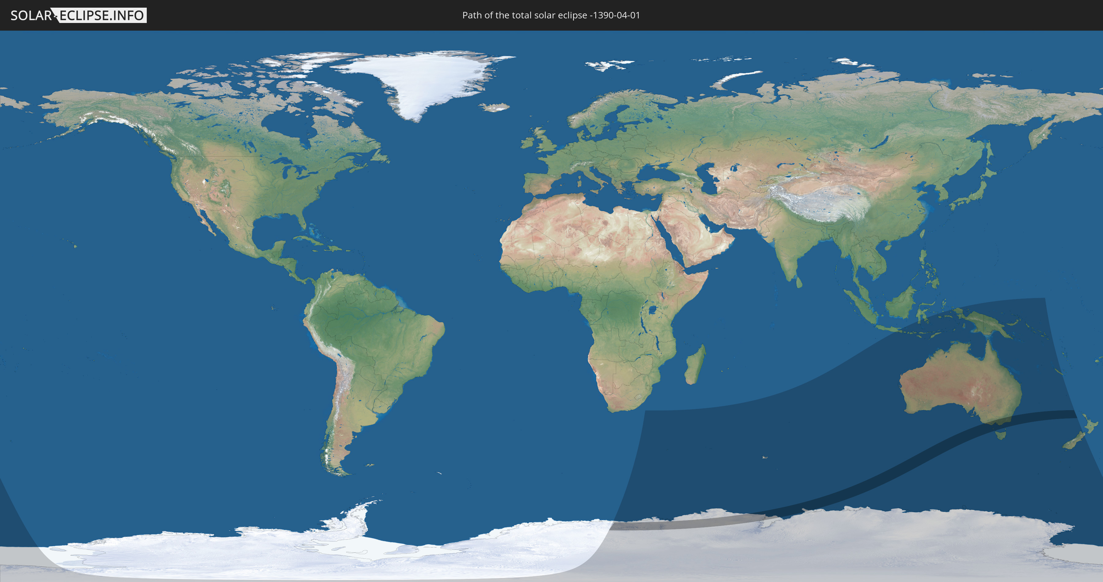
Die Sonnenfinsternis am 04/01/-1390 kann man in 11 Ländern als partielle Sonnenfinsternis beobachten.
Der Finsternispfad verläuft durch 2 Länder. Nur in diesen Ländern ist sie als total Sonnenfinsternis zu sehen.
In den folgenden Ländern ist die Sonnenfinsternis total zu sehen
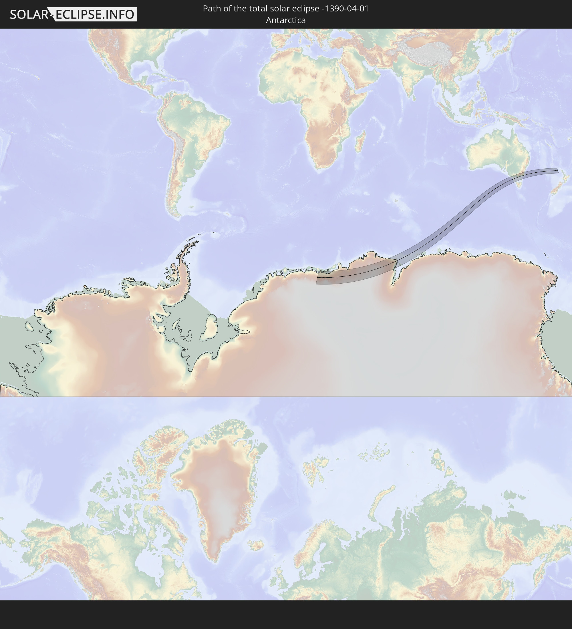 Antarctica
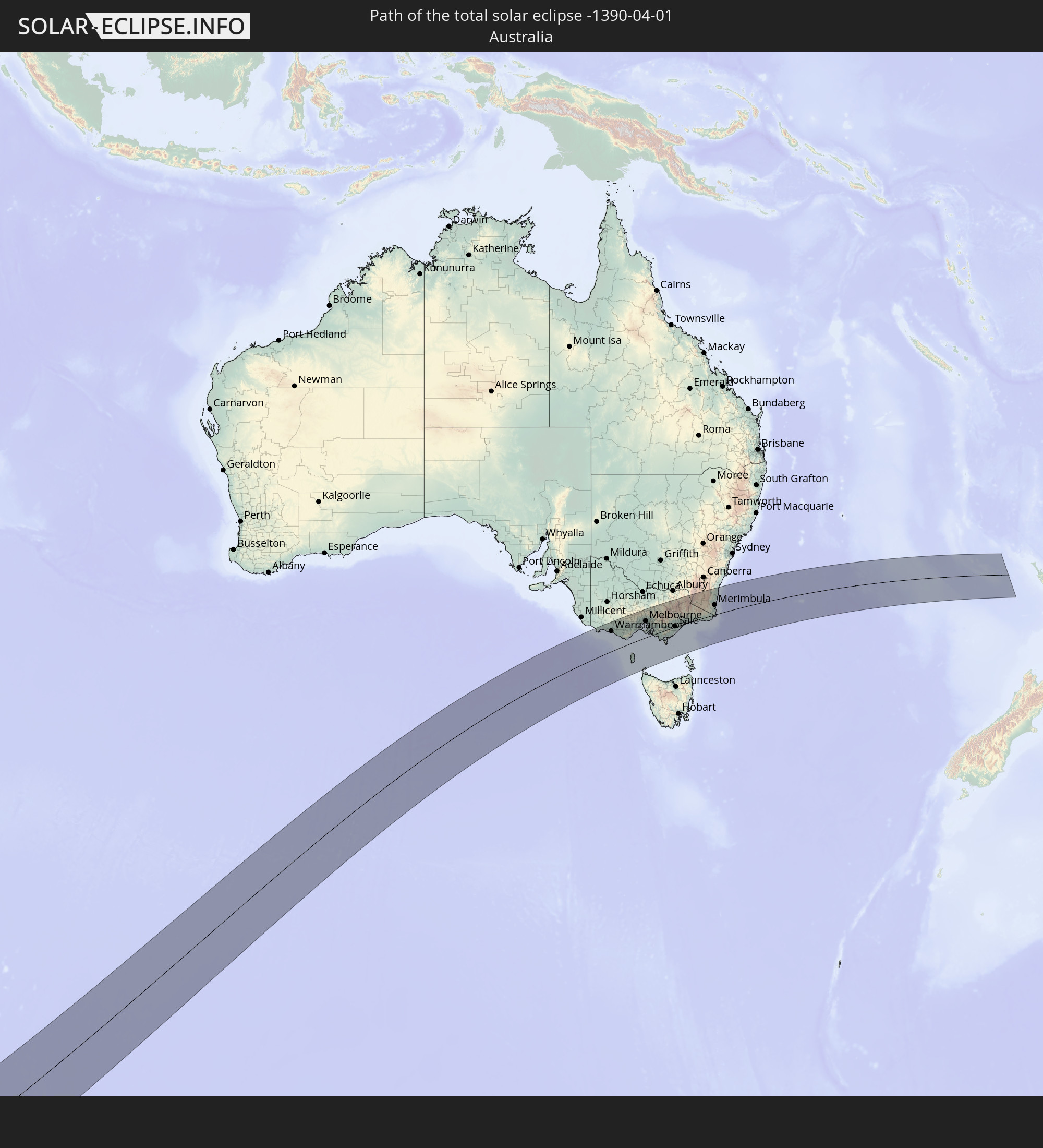 Australia
In den folgenden Ländern ist die Sonnenfinsternis partiell zu sehen


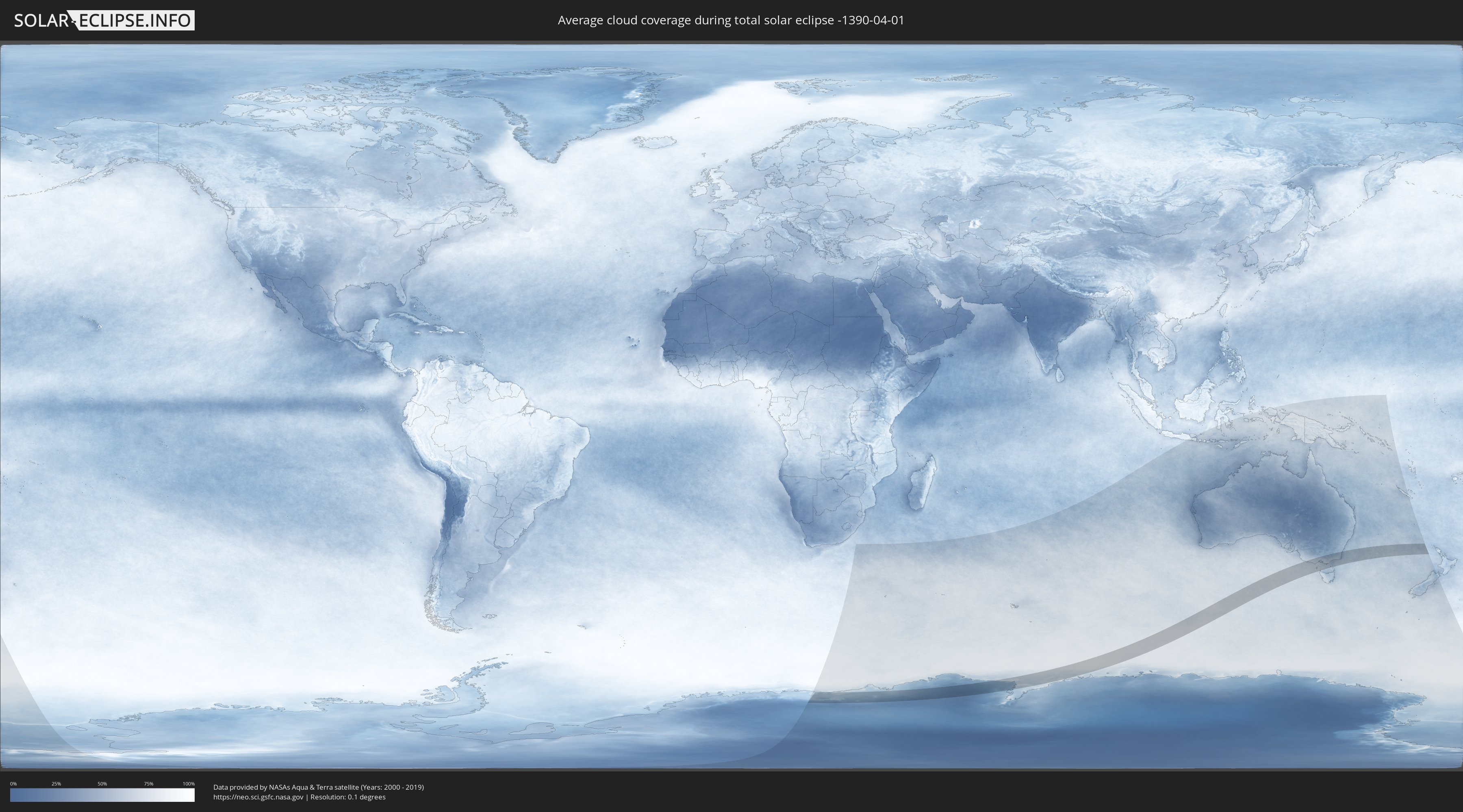
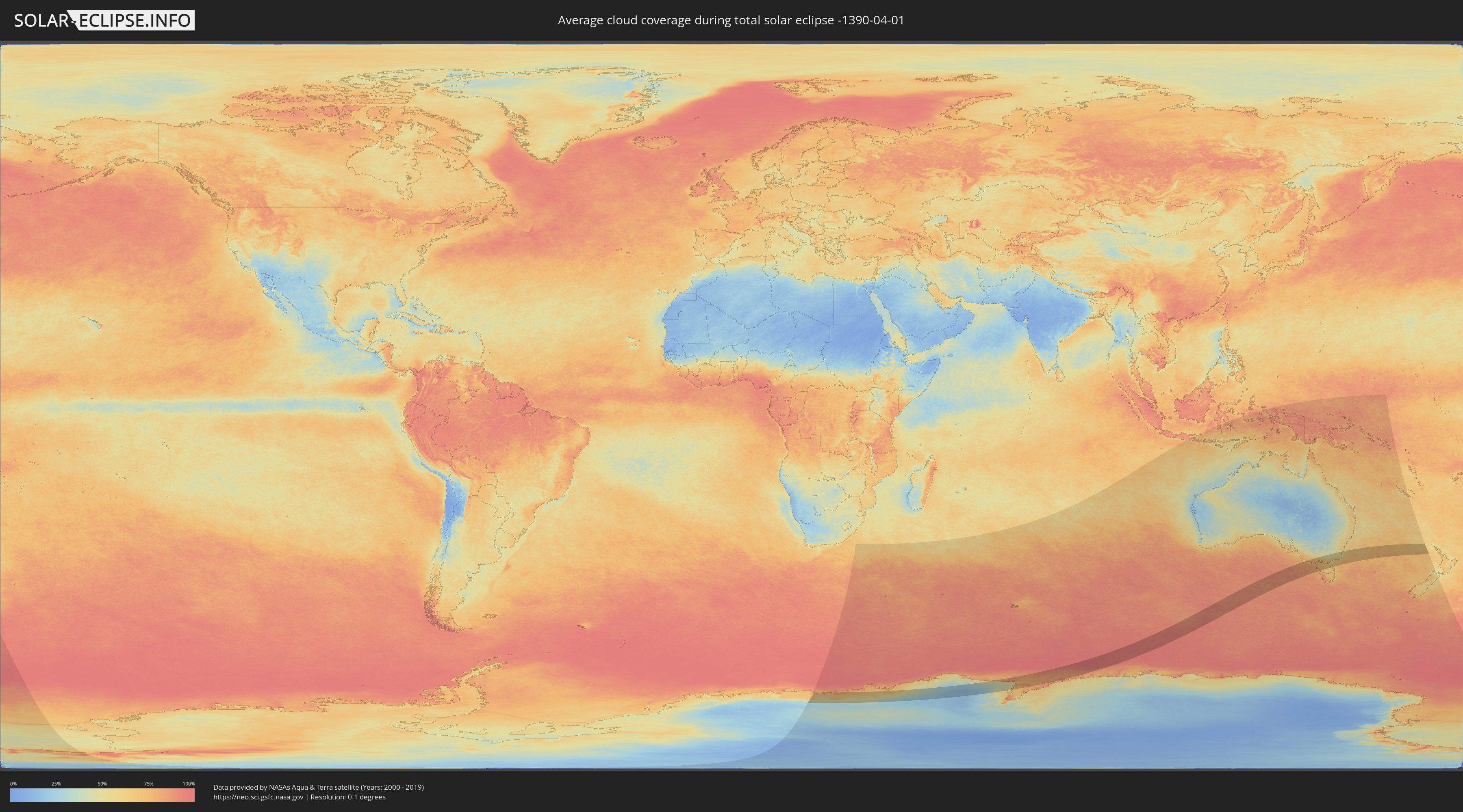
How will be the weather during the total solar eclipse on 04/01/-1390?
Where is the best place to see the total solar eclipse of 04/01/-1390?
The following maps show the average cloud coverage for the day of the total solar eclipse.
With the help of these maps, it is possible to find the place along the eclipse path, which has the best
chance of a cloudless sky.
Nevertheless, you should consider local circumstances and inform about the weather of your chosen
observation site.
The data is provided by NASAs satellites
AQUA and TERRA.
The cloud maps are averaged over a period of 19 years (2000 - 2019).
Detailed country maps
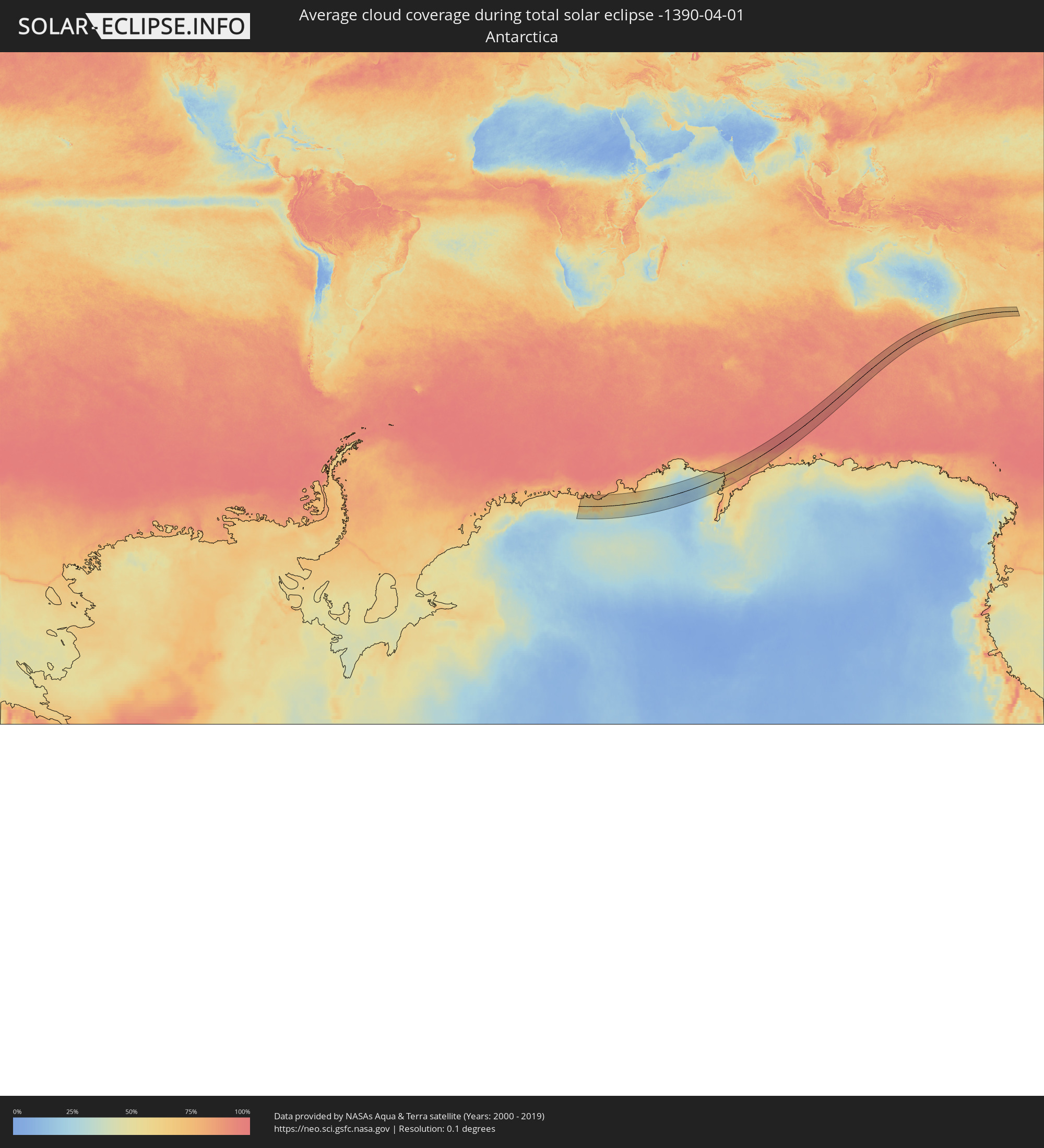 Antarctica
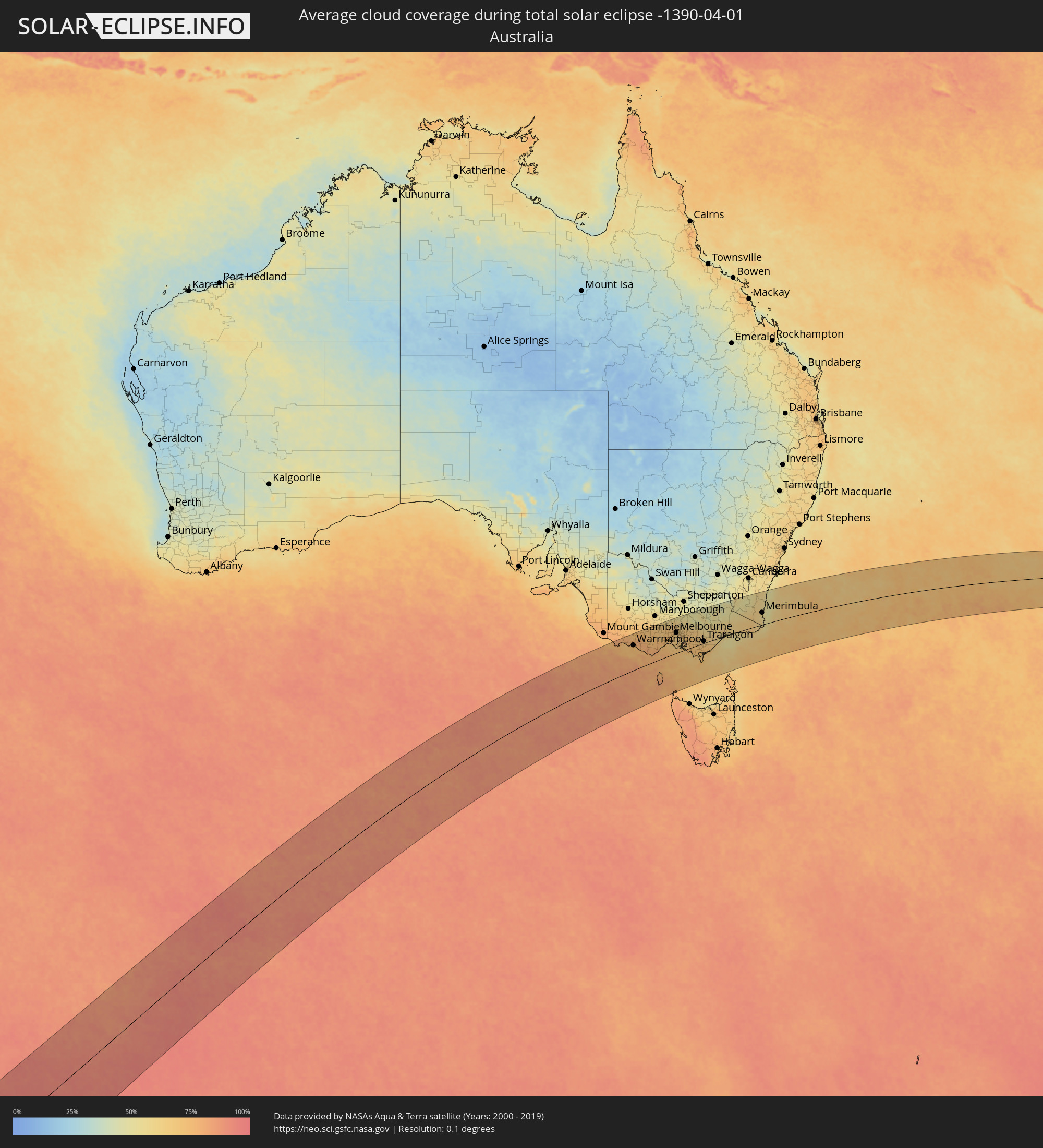 Australia
Cities inside the path of the eclipse
The following table shows all locations with a population of more than 5,000 inside the eclipse path. Cities which have more than 100,000 inhabitants are marked bold. A click at the locations opens a detailed map.
| City | Type | Eclipse duration | Local time of max. eclipse | Distance to central line | Ø Cloud coverage |
 Portland, Victoria
|
total | - | 16:28:14 UTC+10:00 | 150 km | 75% |
|
Warrnambool, Victoria
|
total | - | 16:28:55 UTC+10:00 | 115 km | 72% |
|
Colac, Victoria
|
total | - | 16:29:54 UTC+10:00 | 84 km | 74% |
|
Sebastopol, Victoria
|
total | - | 16:31:23 UTC+10:00 | 154 km | 70% |
|
Ballarat, Victoria
|
total | - | 16:31:26 UTC+10:00 | 156 km | 70% |
|
Ballarat Central, Victoria
|
total | - | 16:31:26 UTC+10:00 | 156 km | 68% |
|
Hamlyn Heights, Victoria
|
total | - | 16:30:51 UTC+10:00 | 84 km | 73% |
|
Geelong West, Victoria
|
total | - | 16:30:50 UTC+10:00 | 82 km | 73% |
|
Geelong, Victoria
|
total | - | 16:30:50 UTC+10:00 | 81 km | 72% |
|
Lara, Victoria
|
total | - | 16:31:05 UTC+10:00 | 93 km | 73% |
|
Bacchus Marsh, Victoria
|
total | - | 16:31:42 UTC+10:00 | 126 km | 69% |
|
Leopold, Victoria
|
total | - | 16:30:51 UTC+10:00 | 75 km | 69% |
|
Wyndham Vale, Victoria
|
total | - | 16:31:30 UTC+10:00 | 106 km | 72% |
|
Clifton Springs, Victoria
|
total | - | 16:30:58 UTC+10:00 | 74 km | 69% |
|
Melton West, Victoria
|
total | - | 16:31:48 UTC+10:00 | 122 km | 70% |
|
Melton South, Victoria
|
total | - | 16:31:45 UTC+10:00 | 119 km | 70% |
|
Melton, Victoria
|
total | - | 16:31:48 UTC+10:00 | 121 km | 70% |
|
Kurunjang, Victoria
|
total | - | 16:31:49 UTC+10:00 | 121 km | 70% |
|
Hoppers Crossing, Victoria
|
total | - | 16:31:33 UTC+10:00 | 97 km | 68% |
|
Sunbury, Victoria
|
total | - | 16:32:05 UTC+10:00 | 129 km | 71% |
|
Caroline Springs, Victoria
|
total | - | 16:31:49 UTC+10:00 | 111 km | 71% |
|
Hillside, Victoria
|
total | - | 16:31:54 UTC+10:00 | 117 km | 71% |
|
Truganina, Victoria
|
total | - | 16:31:42 UTC+10:00 | 103 km | 67% |
|
Taylors Hill, Victoria
|
total | - | 16:31:53 UTC+10:00 | 114 km | 72% |
|
Sydenham, Victoria
|
total | - | 16:31:55 UTC+10:00 | 115 km | 72% |
|
Derrimut, Victoria
|
total | - | 16:31:45 UTC+10:00 | 105 km | 67% |
|
Delahey, Victoria
|
total | - | 16:31:53 UTC+10:00 | 113 km | 72% |
|
Deer Park, Victoria
|
total | - | 16:31:49 UTC+10:00 | 108 km | 67% |
|
Taylors Lakes, Victoria
|
total | - | 16:31:56 UTC+10:00 | 115 km | 72% |
|
Cairnlea, Victoria
|
total | - | 16:31:50 UTC+10:00 | 108 km | 67% |
|
Saint Albans, Victoria
|
total | - | 16:31:53 UTC+10:00 | 111 km | 72% |
|
Keilor Downs, Victoria
|
total | - | 16:31:54 UTC+10:00 | 112 km | 72% |
|
Sunshine West, Victoria
|
total | - | 16:31:48 UTC+10:00 | 104 km | 67% |
|
Rye, Victoria
|
total | - | 16:30:48 UTC+10:00 | 42 km | 67% |
|
Sunshine North, Victoria
|
total | - | 16:31:50 UTC+10:00 | 107 km | 67% |
|
Altona, Victoria
|
total | - | 16:31:40 UTC+10:00 | 96 km | 64% |
|
Keilor, Victoria
|
total | - | 16:31:56 UTC+10:00 | 112 km | 72% |
|
Altona North, Victoria
|
total | - | 16:31:44 UTC+10:00 | 99 km | 67% |
|
Braybrook, Victoria
|
total | - | 16:31:50 UTC+10:00 | 104 km | 65% |
|
Keilor East, Victoria
|
total | - | 16:31:56 UTC+10:00 | 109 km | 69% |
|
Greenvale, Victoria
|
total | - | 16:32:06 UTC+10:00 | 118 km | 69% |
|
Maidstone, Victoria
|
total | - | 16:31:51 UTC+10:00 | 104 km | 65% |
|
West Footscray, Victoria
|
total | - | 16:31:50 UTC+10:00 | 102 km | 65% |
|
Tullamarine, Victoria
|
total | - | 16:32:00 UTC+10:00 | 111 km | 69% |
|
Airport West, Victoria
|
total | - | 16:31:57 UTC+10:00 | 109 km | 69% |
|
Maribyrnong, Victoria
|
total | - | 16:31:51 UTC+10:00 | 103 km | 65% |
|
Newport, Victoria
|
total | - | 16:31:45 UTC+10:00 | 97 km | 65% |
|
Gladstone Park, Victoria
|
total | - | 16:32:01 UTC+10:00 | 112 km | 69% |
|
Williamstown, Victoria
|
total | - | 16:31:44 UTC+10:00 | 96 km | 61% |
|
Footscray, Victoria
|
total | - | 16:31:50 UTC+10:00 | 101 km | 65% |
|
Yarraville, Victoria
|
total | - | 16:31:49 UTC+10:00 | 99 km | 65% |
|
Rosebud, Victoria
|
total | - | 16:30:54 UTC+10:00 | 41 km | 67% |
|
Ascot Vale, Victoria
|
total | - | 16:31:53 UTC+10:00 | 102 km | 65% |
|
Moonee Ponds, Victoria
|
total | - | 16:31:55 UTC+10:00 | 103 km | 65% |
|
Meadow Heights, Victoria
|
total | - | 16:32:07 UTC+10:00 | 115 km | 69% |
|
Broadmeadows, Victoria
|
total | - | 16:32:04 UTC+10:00 | 112 km | 69% |
|
Oak Park, Victoria
|
total | - | 16:32:00 UTC+10:00 | 108 km | 69% |
|
Flemington, Victoria
|
total | - | 16:31:53 UTC+10:00 | 101 km | 65% |
|
Kensington, Victoria
|
total | - | 16:31:54 UTC+10:00 | 101 km | 65% |
|
Pascoe Vale, Victoria
|
total | - | 16:31:59 UTC+10:00 | 106 km | 69% |
|
Port Melbourne, Victoria
|
total | - | 16:31:48 UTC+10:00 | 95 km | 65% |
|
Brunswick West, Victoria
|
total | - | 16:31:56 UTC+10:00 | 102 km | 65% |
|
Pascoe Vale South, Victoria
|
total | - | 16:31:59 UTC+10:00 | 105 km | 69% |
|
North Melbourne, Victoria
|
total | - | 16:31:52 UTC+10:00 | 98 km | 65% |
|
Parkville, Victoria
|
total | - | 16:31:54 UTC+10:00 | 100 km | 65% |
|
Docklands, Victoria
|
total | - | 16:31:51 UTC+10:00 | 97 km | 65% |
|
Coburg North, Victoria
|
total | - | 16:32:01 UTC+10:00 | 105 km | 66% |
|
Melbourne, Victoria
|
total | - | 16:31:52 UTC+10:00 | 97 km | 65% |
|
Southbank, Victoria
|
total | - | 16:31:51 UTC+10:00 | 96 km | 65% |
|
Fawkner, Victoria
|
total | - | 16:32:02 UTC+10:00 | 106 km | 66% |
|
South Melbourne, Victoria
|
total | - | 16:31:50 UTC+10:00 | 95 km | 65% |
|
Carlton, Victoria
|
total | - | 16:31:53 UTC+10:00 | 98 km | 65% |
|
North Melbourne, Victoria
|
total | - | 16:31:53 UTC+10:00 | 98 km | 65% |
|
Carlton North, Victoria
|
total | - | 16:31:55 UTC+10:00 | 100 km | 65% |
|
Brunswick East, Victoria
|
total | - | 16:31:57 UTC+10:00 | 100 km | 65% |
|
Fitzroy, Victoria
|
total | - | 16:31:54 UTC+10:00 | 98 km | 65% |
|
North Fitzroy, Victoria
|
total | - | 16:31:55 UTC+10:00 | 99 km | 65% |
|
Elwood, Victoria
|
total | - | 16:31:46 UTC+10:00 | 89 km | 61% |
|
Windsor, Victoria
|
total | - | 16:31:49 UTC+10:00 | 92 km | 61% |
|
Clifton Hill, Victoria
|
total | - | 16:31:55 UTC+10:00 | 97 km | 65% |
|
Albert Park, Victoria
|
total | - | 16:31:52 UTC+10:00 | 93 km | 65% |
|
Hampton, Victoria
|
total | - | 16:31:40 UTC+10:00 | 82 km | 60% |
|
Thornbury, Victoria
|
total | - | 16:32:00 UTC+10:00 | 102 km | 65% |
|
St Kilda East, Victoria
|
total | - | 16:31:48 UTC+10:00 | 90 km | 61% |
|
Elsternwick, Victoria
|
total | - | 16:31:46 UTC+10:00 | 88 km | 61% |
|
Toorak, Victoria
|
total | - | 16:31:51 UTC+10:00 | 92 km | 65% |
|
Black Rock, Victoria
|
total | - | 16:31:38 UTC+10:00 | 79 km | 60% |
|
Mount Martha, Victoria
|
total | - | 16:31:08 UTC+10:00 | 50 km | 69% |
|
Brighton East, Victoria
|
total | - | 16:31:45 UTC+10:00 | 86 km | 61% |
|
Fairfield, Victoria
|
total | - | 16:31:58 UTC+10:00 | 98 km | 65% |
|
Caulfield North, Victoria
|
total | - | 16:31:49 UTC+10:00 | 89 km | 61% |
|
Caulfield North, Victoria
|
total | - | 16:31:49 UTC+10:00 | 88 km | 61% |
|
Caulfield South, Victoria
|
total | - | 16:31:46 UTC+10:00 | 86 km | 61% |
|
Ormond, Victoria
|
total | - | 16:31:46 UTC+10:00 | 85 km | 61% |
|
Epping, Victoria
|
total | - | 16:32:12 UTC+10:00 | 111 km | 66% |
|
Beaumaris, Victoria
|
total | - | 16:31:37 UTC+10:00 | 77 km | 60% |
|
Bentleigh, Victoria
|
total | - | 16:31:44 UTC+10:00 | 84 km | 61% |
|
Hawthorn East, Victoria
|
total | - | 16:31:55 UTC+10:00 | 92 km | 65% |
|
Cheltenham, Victoria
|
total | - | 16:31:40 UTC+10:00 | 78 km | 60% |
|
McKinnon, Victoria
|
total | - | 16:31:45 UTC+10:00 | 83 km | 65% |
|
Highett, Victoria
|
total | - | 16:31:42 UTC+10:00 | 80 km | 63% |
|
Kew East, Victoria
|
total | - | 16:31:58 UTC+10:00 | 95 km | 66% |
|
Heidelberg Heights, Victoria
|
total | - | 16:32:03 UTC+10:00 | 100 km | 65% |
|
Murrumbeena, Victoria
|
total | - | 16:31:48 UTC+10:00 | 84 km | 65% |
|
Carnegie, Victoria
|
total | - | 16:31:49 UTC+10:00 | 86 km | 65% |
|
Macleod, Victoria
|
total | - | 16:32:05 UTC+10:00 | 101 km | 65% |
|
Mentone, Victoria
|
total | - | 16:31:39 UTC+10:00 | 76 km | 63% |
|
Heidelberg, Victoria
|
total | - | 16:32:03 UTC+10:00 | 99 km | 66% |
|
Rosanna, Victoria
|
total | - | 16:32:03 UTC+10:00 | 99 km | 66% |
|
Parkdale, Victoria
|
total | - | 16:31:39 UTC+10:00 | 76 km | 63% |
|
Balwyn, Victoria
|
total | - | 16:31:56 UTC+10:00 | 92 km | 66% |
|
Mount Eliza, Victoria
|
total | - | 16:31:19 UTC+10:00 | 57 km | 67% |
|
Hughesdale, Victoria
|
total | - | 16:31:48 UTC+10:00 | 83 km | 65% |
|
Bulleen, Victoria
|
total | - | 16:32:02 UTC+10:00 | 97 km | 66% |
|
Mordialloc, Victoria
|
total | - | 16:31:38 UTC+10:00 | 73 km | 63% |
|
Ashburton, Victoria
|
total | - | 16:31:52 UTC+10:00 | 87 km | 65% |
|
Canterbury, Victoria
|
total | - | 16:31:56 UTC+10:00 | 91 km | 66% |
|
Oakleigh South, Victoria
|
total | - | 16:31:46 UTC+10:00 | 81 km | 65% |
|
Viewbank, Victoria
|
total | - | 16:32:05 UTC+10:00 | 99 km | 65% |
|
Chadstone, Victoria
|
total | - | 16:31:50 UTC+10:00 | 84 km | 65% |
|
Mernda, Victoria
|
total | - | 16:32:20 UTC+10:00 | 114 km | 66% |
|
Surrey Hills, Victoria
|
total | - | 16:31:58 UTC+10:00 | 91 km | 66% |
|
Aspendale, Victoria
|
total | - | 16:31:36 UTC+10:00 | 70 km | 63% |
|
Ashwood, Victoria
|
total | - | 16:31:53 UTC+10:00 | 86 km | 65% |
|
Clayton, Victoria
|
total | - | 16:31:48 UTC+10:00 | 80 km | 65% |
|
Montmorency, Victoria
|
total | - | 16:32:09 UTC+10:00 | 101 km | 65% |
|
Clayton South, Victoria
|
total | - | 16:31:47 UTC+10:00 | 79 km | 65% |
|
Templestowe Lower, Victoria
|
total | - | 16:32:04 UTC+10:00 | 96 km | 66% |
|
Clarinda, Victoria
|
total | - | 16:31:47 UTC+10:00 | 79 km | 65% |
|
Chelsea, Victoria
|
total | - | 16:31:35 UTC+10:00 | 67 km | 64% |
|
Aspendale Gardens, Victoria
|
total | - | 16:31:37 UTC+10:00 | 70 km | 63% |
|
Burwood, Victoria
|
total | - | 16:31:55 UTC+10:00 | 87 km | 66% |
|
Box Hill South, Victoria
|
total | - | 16:31:57 UTC+10:00 | 89 km | 66% |
|
Bonbeach, Victoria
|
total | - | 16:31:33 UTC+10:00 | 65 km | 64% |
|
Frankston, Victoria
|
total | - | 16:31:25 UTC+10:00 | 58 km | 64% |
|
Box Hill, Victoria
|
total | - | 16:31:59 UTC+10:00 | 90 km | 66% |
|
Box Hill North, Victoria
|
total | - | 16:32:00 UTC+10:00 | 92 km | 66% |
|
Seaford, Victoria
|
total | - | 16:31:30 UTC+10:00 | 62 km | 64% |
|
Dingley Village, Victoria
|
total | - | 16:31:42 UTC+10:00 | 73 km | 63% |
|
Frankston South, Victoria
|
total | - | 16:31:24 UTC+10:00 | 55 km | 67% |
|
Patterson Lakes, Victoria
|
total | - | 16:31:34 UTC+10:00 | 64 km | 64% |
|
Frankston North, Victoria
|
total | - | 16:31:28 UTC+10:00 | 59 km | 64% |
|
Doncaster East, Victoria
|
total | - | 16:32:03 UTC+10:00 | 93 km | 66% |
|
Eltham North, Victoria
|
total | - | 16:32:12 UTC+10:00 | 102 km | 66% |
|
Doreen, Victoria
|
total | - | 16:32:22 UTC+10:00 | 113 km | 64% |
|
Springvale South, Victoria
|
total | - | 16:31:45 UTC+10:00 | 74 km | 70% |
|
Diamond Creek, Victoria
|
total | - | 16:32:15 UTC+10:00 | 106 km | 66% |
|
Burwood East, Victoria
|
total | - | 16:31:57 UTC+10:00 | 86 km | 69% |
|
Blackburn North, Victoria
|
total | - | 16:32:01 UTC+10:00 | 90 km | 68% |
|
Blackburn, Victoria
|
total | - | 16:32:00 UTC+10:00 | 89 km | 68% |
|
Blackburn South, Victoria
|
total | - | 16:31:58 UTC+10:00 | 87 km | 68% |
|
Somerville, Victoria
|
total | - | 16:31:20 UTC+10:00 | 49 km | 66% |
|
Carrum Downs, Victoria
|
total | - | 16:31:32 UTC+10:00 | 60 km | 66% |
|
Nunawading, Victoria
|
total | - | 16:32:01 UTC+10:00 | 89 km | 68% |
|
Donvale, Victoria
|
total | - | 16:32:04 UTC+10:00 | 92 km | 68% |
|
Vermont South, Victoria
|
total | - | 16:31:57 UTC+10:00 | 84 km | 69% |
|
Forest Hill, Victoria
|
total | - | 16:32:00 UTC+10:00 | 87 km | 68% |
|
Hastings, Victoria
|
total | - | 16:31:12 UTC+10:00 | 41 km | 66% |
|
Noble Park North, Victoria
|
total | - | 16:31:48 UTC+10:00 | 74 km | 69% |
|
Vermont, Victoria
|
total | - | 16:32:00 UTC+10:00 | 86 km | 68% |
|
Mitcham, Victoria
|
total | - | 16:32:02 UTC+10:00 | 88 km | 68% |
|
Skye, Victoria
|
total | - | 16:31:33 UTC+10:00 | 58 km | 66% |
|
Wantirna, Victoria
|
total | - | 16:32:00 UTC+10:00 | 84 km | 69% |
|
Phillip Island, Victoria
|
total | - | 16:30:55 UTC+10:00 | 25 km | 69% |
|
Scoresby, Victoria
|
total | - | 16:31:55 UTC+10:00 | 79 km | 69% |
|
Rowville, Victoria
|
total | - | 16:31:52 UTC+10:00 | 75 km | 69% |
|
Doveton, Victoria
|
total | - | 16:31:46 UTC+10:00 | 68 km | 70% |
|
Knoxfield, Victoria
|
total | - | 16:31:57 UTC+10:00 | 79 km | 69% |
|
Heathmont, Victoria
|
total | - | 16:32:03 UTC+10:00 | 85 km | 67% |
|
Ringwood East, Victoria
|
total | - | 16:32:04 UTC+10:00 | 87 km | 67% |
|
Lynbrook, Victoria
|
total | - | 16:31:40 UTC+10:00 | 61 km | 68% |
|
Hallam, Victoria
|
total | - | 16:31:45 UTC+10:00 | 65 km | 69% |
|
Bayswater, Victoria
|
total | - | 16:32:02 UTC+10:00 | 83 km | 68% |
|
Cranbourne West, Victoria
|
total | - | 16:31:37 UTC+10:00 | 57 km | 68% |
|
Cranbourne North, Victoria
|
total | - | 16:31:38 UTC+10:00 | 58 km | 68% |
|
Cranbourne East, Victoria
|
total | - | 16:31:36 UTC+10:00 | 54 km | 68% |
|
Bayswater North, Victoria
|
total | - | 16:32:06 UTC+10:00 | 85 km | 67% |
|
Lysterfield, Victoria
|
total | - | 16:31:55 UTC+10:00 | 73 km | 68% |
|
Croydon North, Victoria
|
total | - | 16:32:10 UTC+10:00 | 90 km | 67% |
|
Chirnside Park, Victoria
|
total | - | 16:32:15 UTC+10:00 | 94 km | 66% |
|
Narre Warren North, Victoria
|
total | - | 16:31:50 UTC+10:00 | 68 km | 69% |
|
Kilsyth, Victoria
|
total | - | 16:32:09 UTC+10:00 | 88 km | 67% |
|
Upwey, Victoria
|
total | - | 16:32:00 UTC+10:00 | 76 km | 68% |
|
Montrose, Victoria
|
total | - | 16:32:09 UTC+10:00 | 85 km | 67% |
|
Lilydale, Victoria
|
total | - | 16:32:16 UTC+10:00 | 93 km | 67% |
|
Berwick, Victoria
|
total | - | 16:31:47 UTC+10:00 | 62 km | 68% |
|
Mount Evelyn, Victoria
|
total | - | 16:32:14 UTC+10:00 | 89 km | 67% |
|
Emerald, Victoria
|
total | - | 16:32:01 UTC+10:00 | 72 km | 68% |
|
Pakenham South, Victoria
|
total | - | 16:31:44 UTC+10:00 | 49 km | 71% |
|
Healesville, Victoria
|
total | - | 16:32:33 UTC+10:00 | 96 km | 66% |
|
North Wonthaggi, Victoria
|
total | - | 16:31:00 UTC+10:00 | 9 km | 70% |
|
Warragul, Victoria
|
total | - | 16:31:59 UTC+10:00 | 31 km | 70% |
|
Moe, Victoria
|
total | - | 16:32:12 UTC+10:00 | 25 km | 69% |
|
Morwell, Victoria
|
total | - | 16:32:12 UTC+10:00 | 11 km | 68% |
|
Traralgon, Victoria
|
total | - | 16:32:22 UTC+10:00 | 12 km | 66% |
|
Sale, Victoria
|
total | - | 16:32:53 UTC+10:00 | 8 km | 64% |
|
Bairnsdale, Victoria
|
total | - | 16:33:44 UTC+10:00 | 25 km | 62% |
|
Lakes Entrance, Victoria
|
total | - | 16:33:53 UTC+10:00 | 3 km | 57% |
|
Cooma, New South Wales
|
total | - | 16:37:23 UTC+10:00 | 149 km | 50% |
|
Merimbula, New South Wales
|
total | - | 16:36:46 UTC+10:00 | 60 km | 55% |