Total solar eclipse of 07/13/-1424
| Day of week: | Thursday |
| Maximum duration of eclipse: | 06m58s |
| Maximum width of eclipse path: | 256 km |
| Saros cycle: | 23 |
| Coverage: | 100% |
| Magnitude: | 1.0736 |
| Gamma: | -0.3564 |
Wo kann man die Sonnenfinsternis vom 07/13/-1424 sehen?
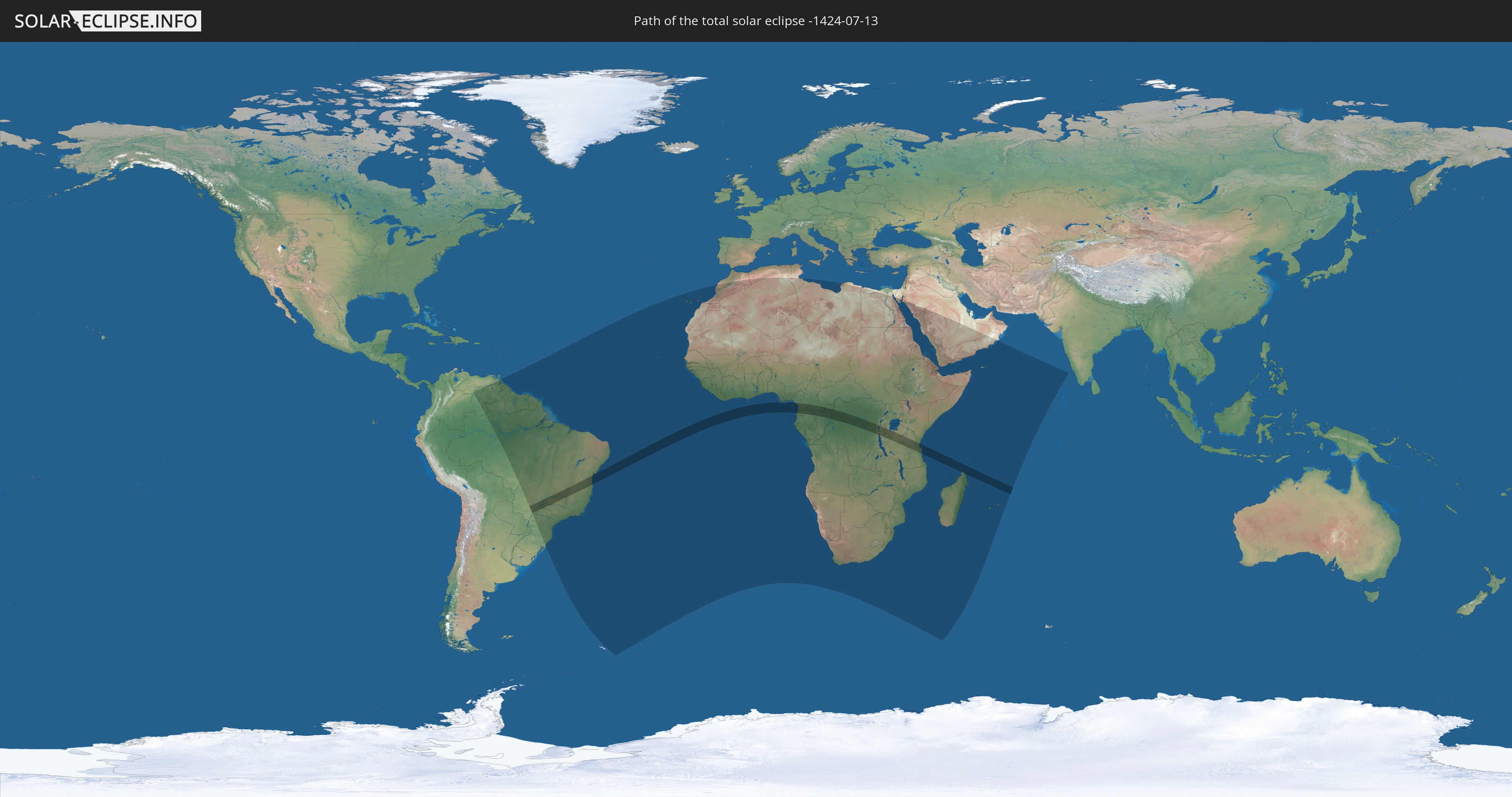
Die Sonnenfinsternis am 07/13/-1424 kann man in 68 Ländern als partielle Sonnenfinsternis beobachten.
Der Finsternispfad verläuft durch 14 Länder. Nur in diesen Ländern ist sie als total Sonnenfinsternis zu sehen.
In den folgenden Ländern ist die Sonnenfinsternis total zu sehen
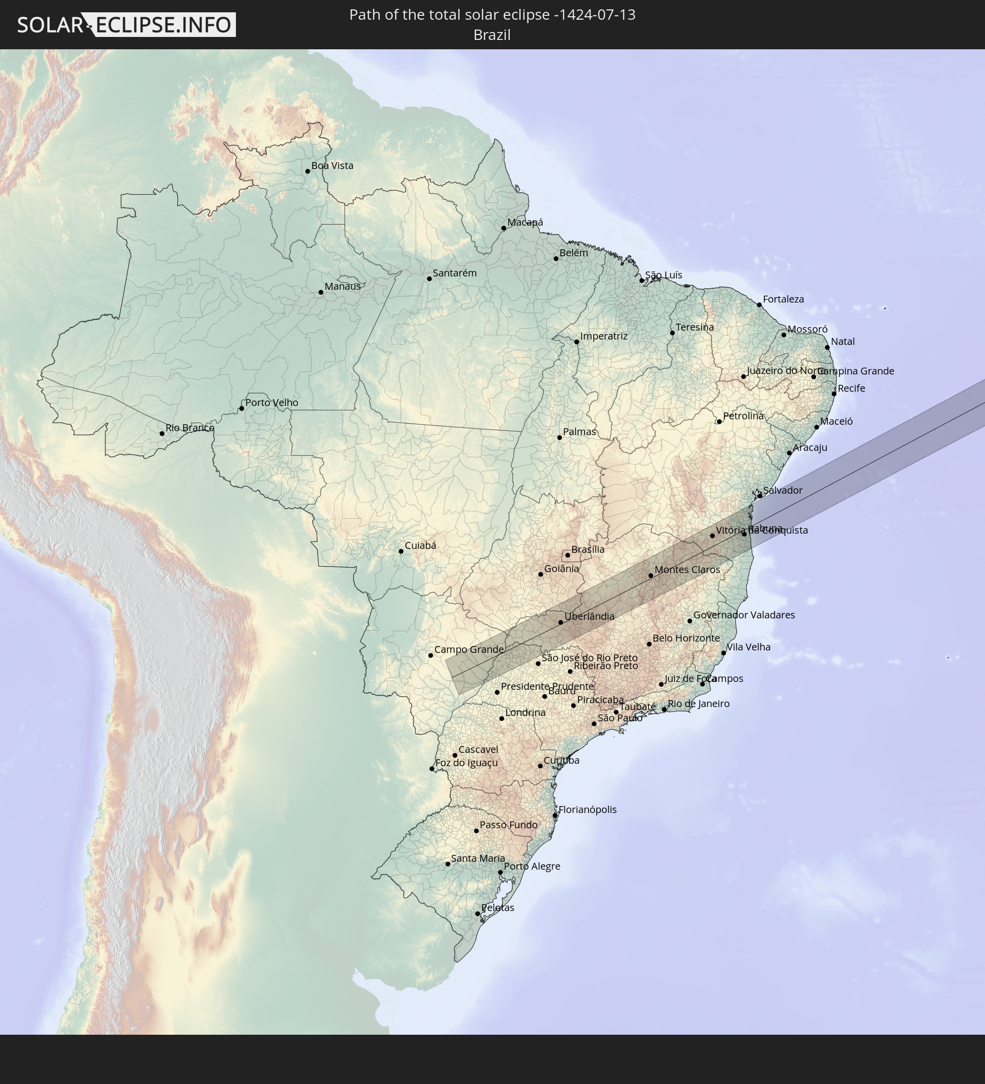 Brazil
 Equatorial Guinea
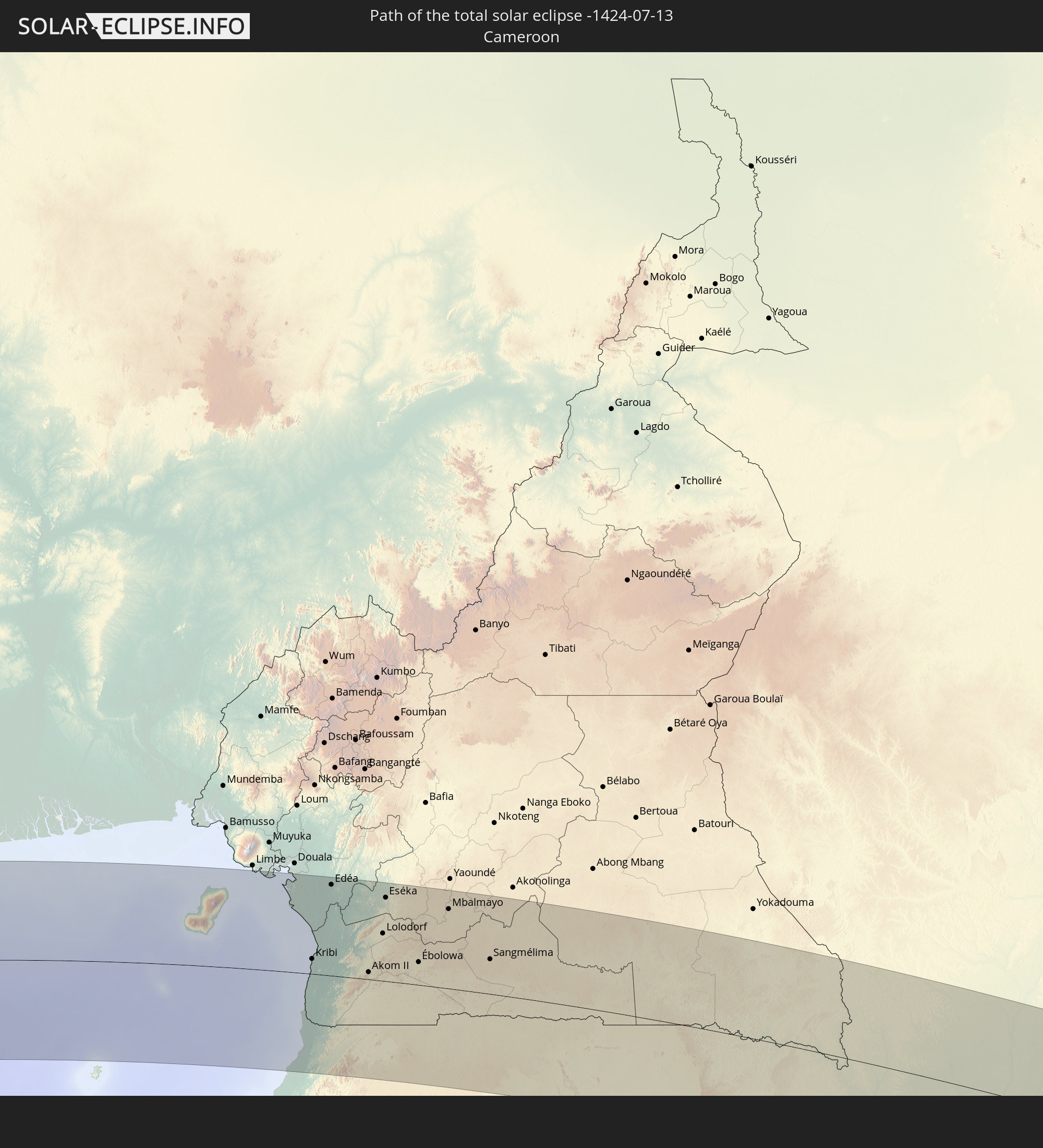 Cameroon
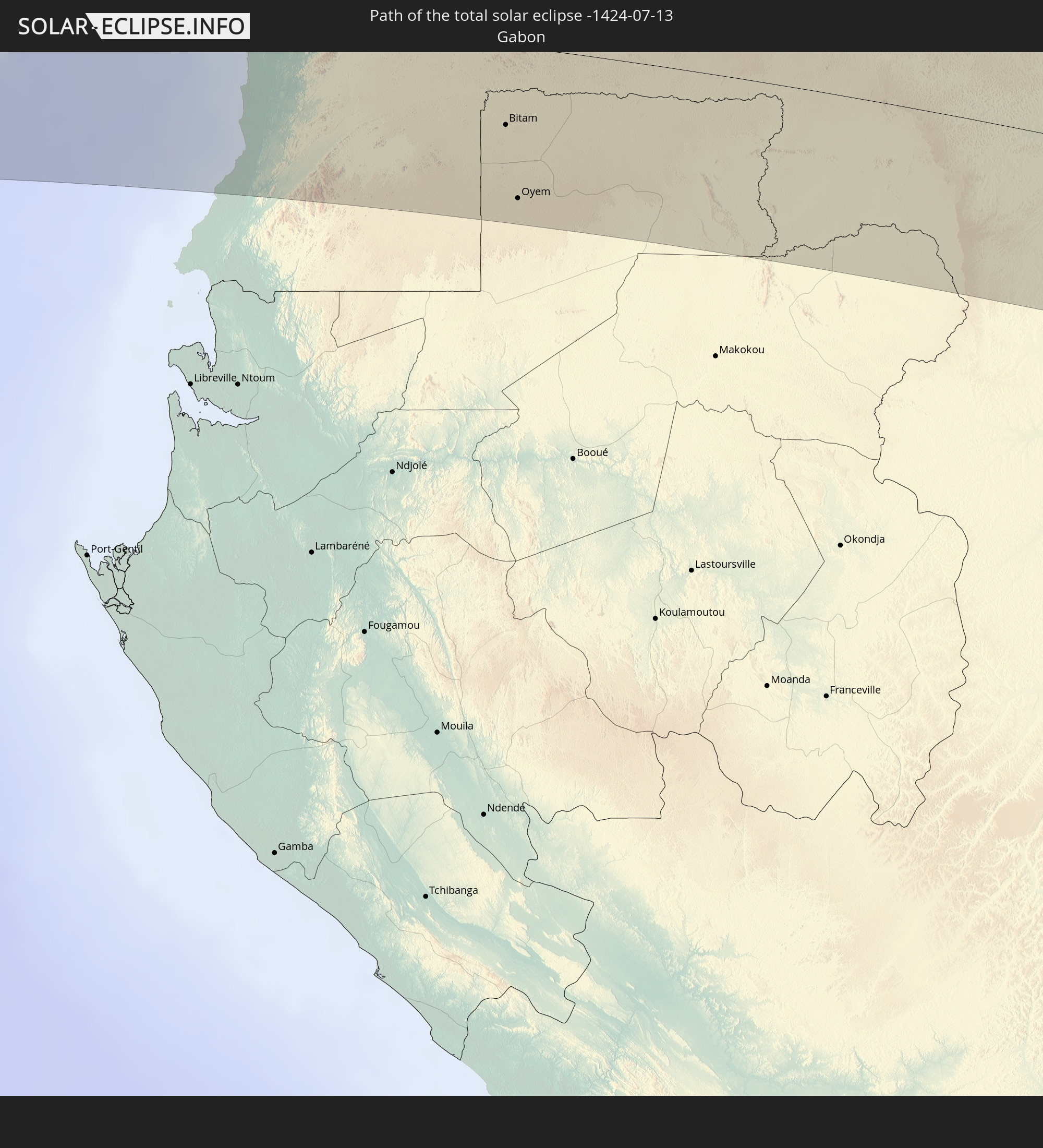 Gabon
Gabon
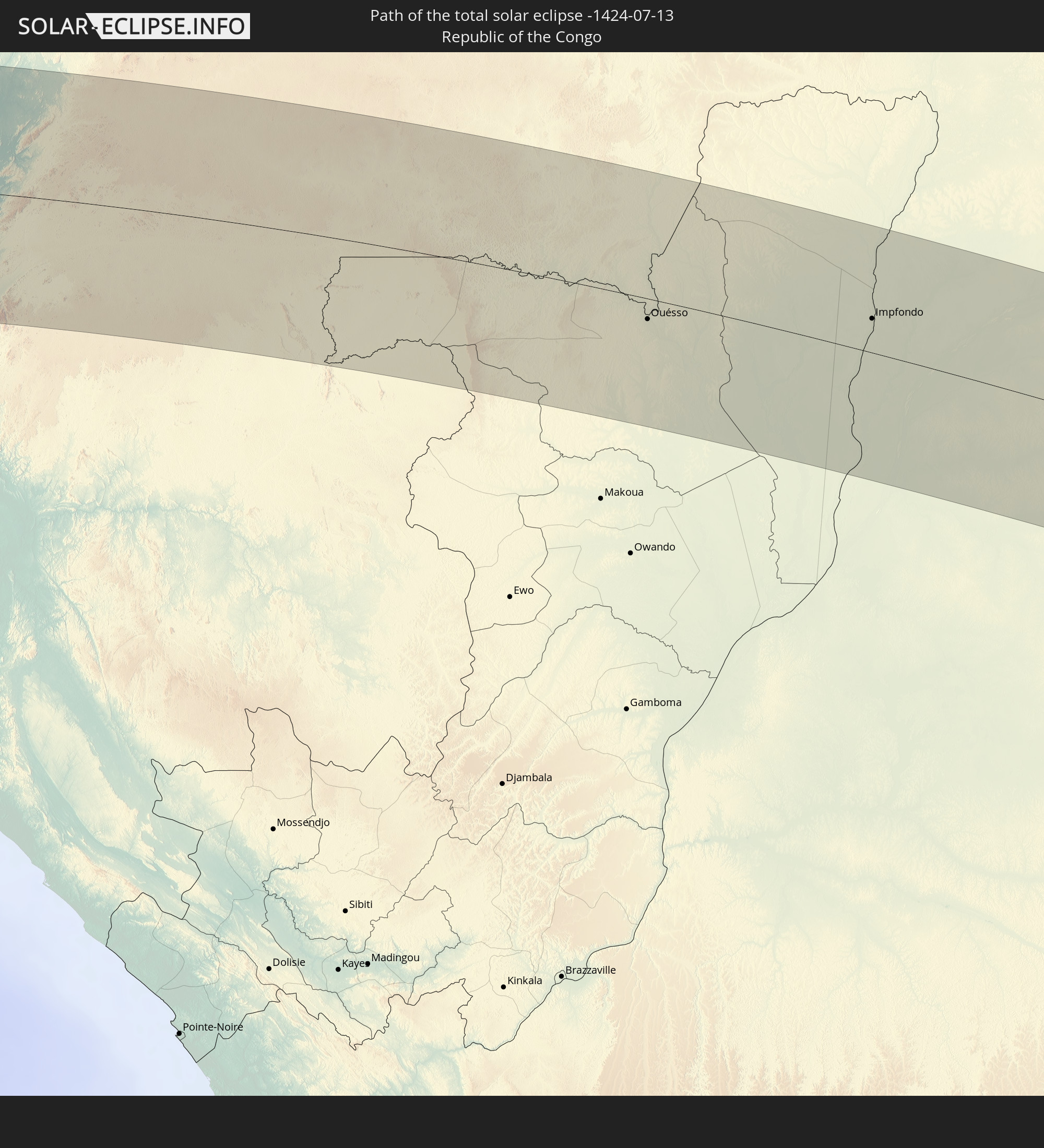 Republic of the Congo
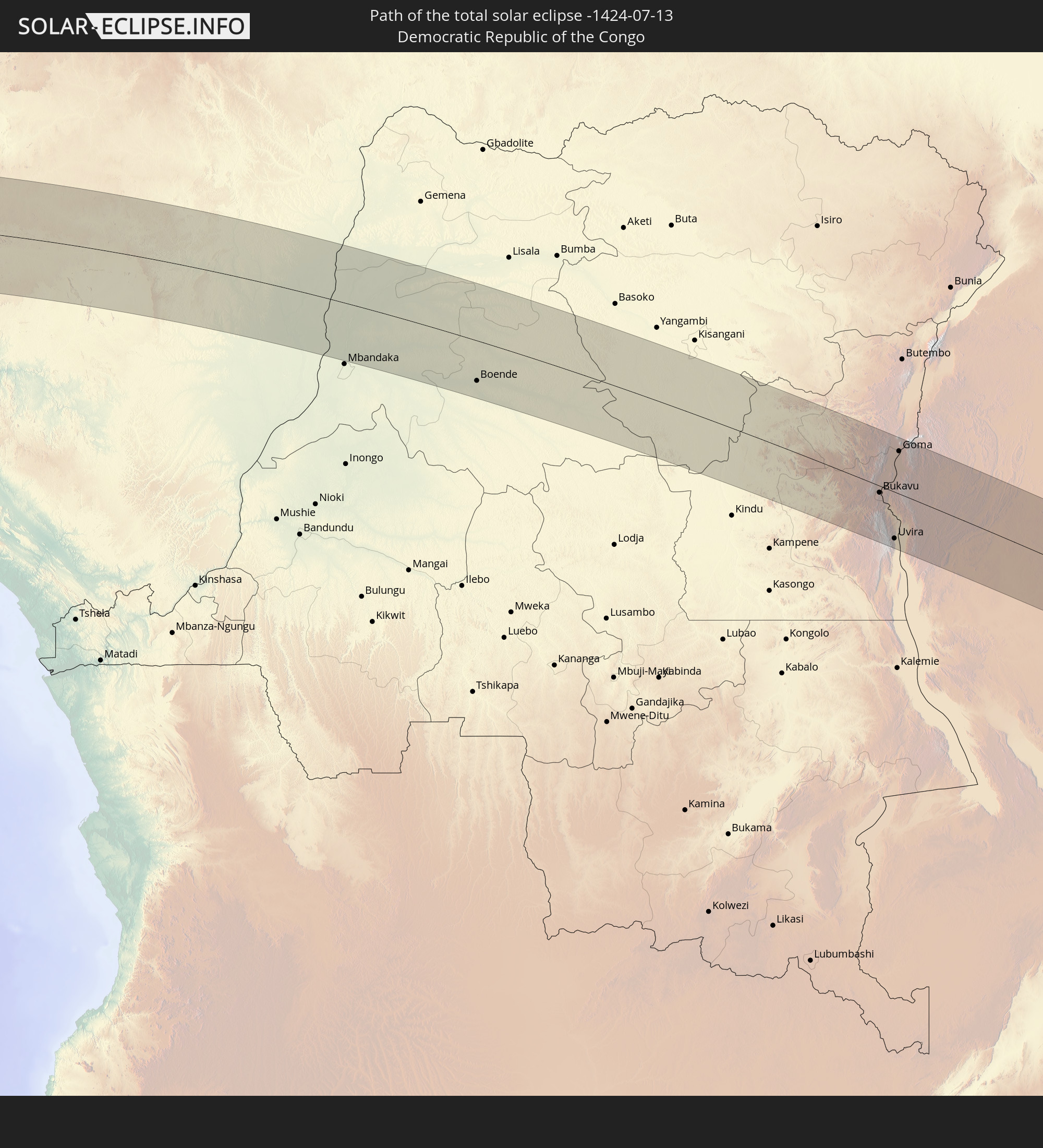 Democratic Republic of the Congo
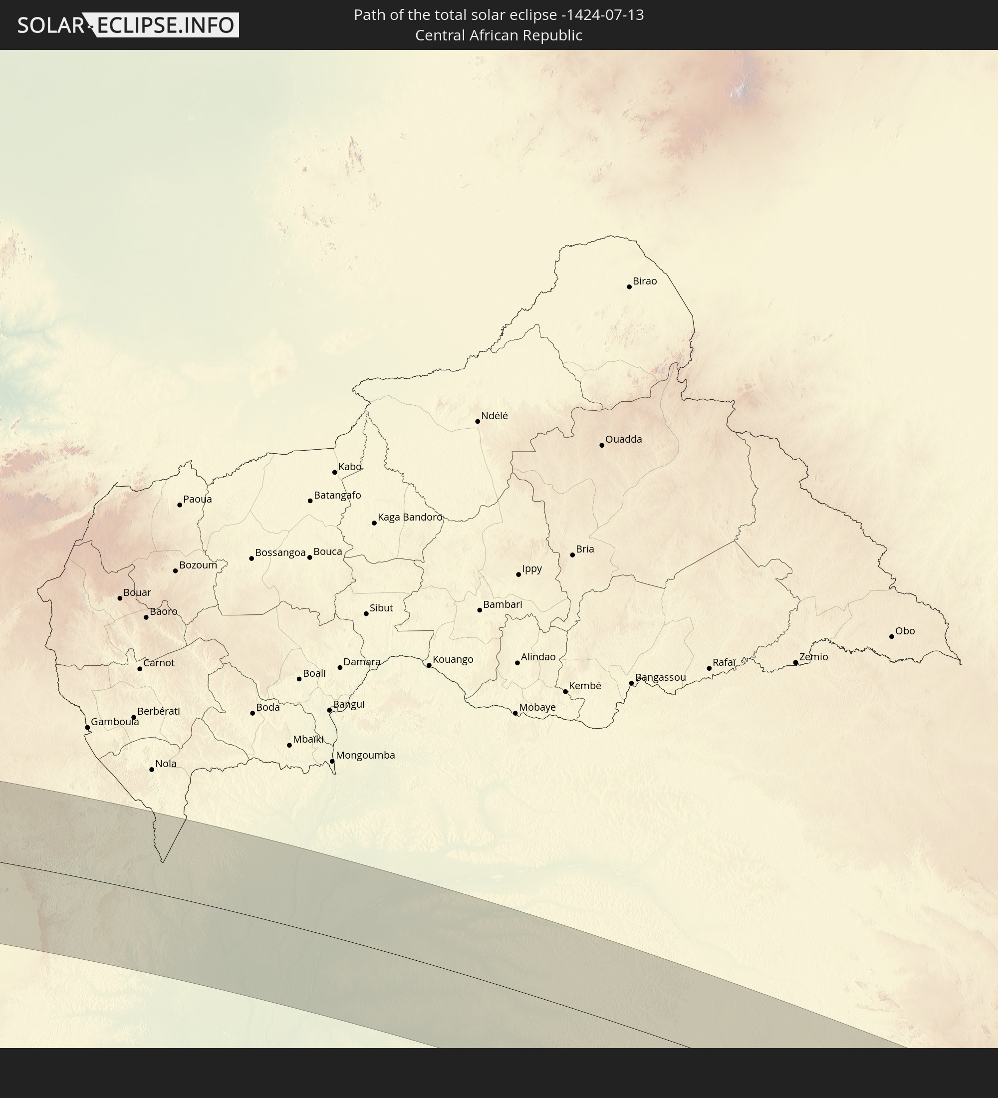 Central African Republic
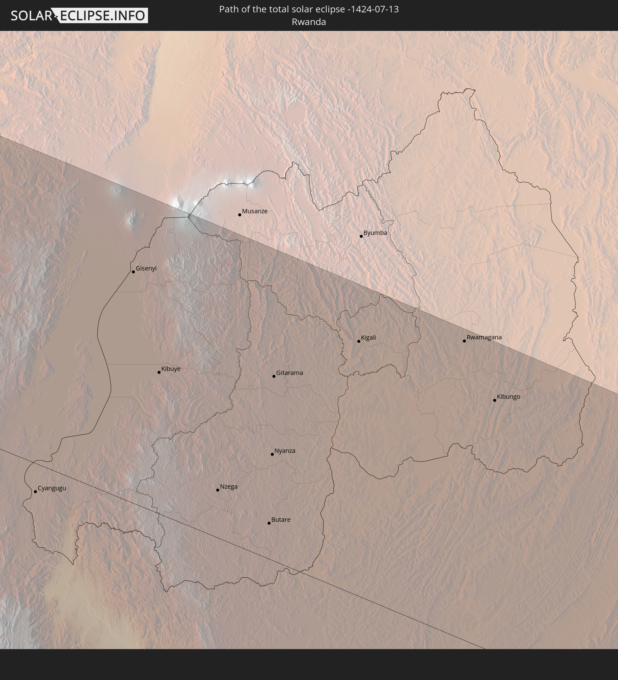 Rwanda
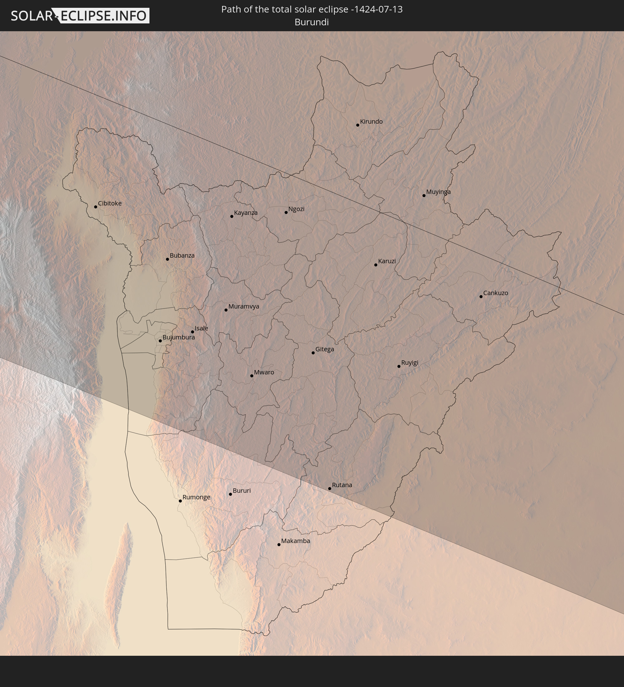 Burundi
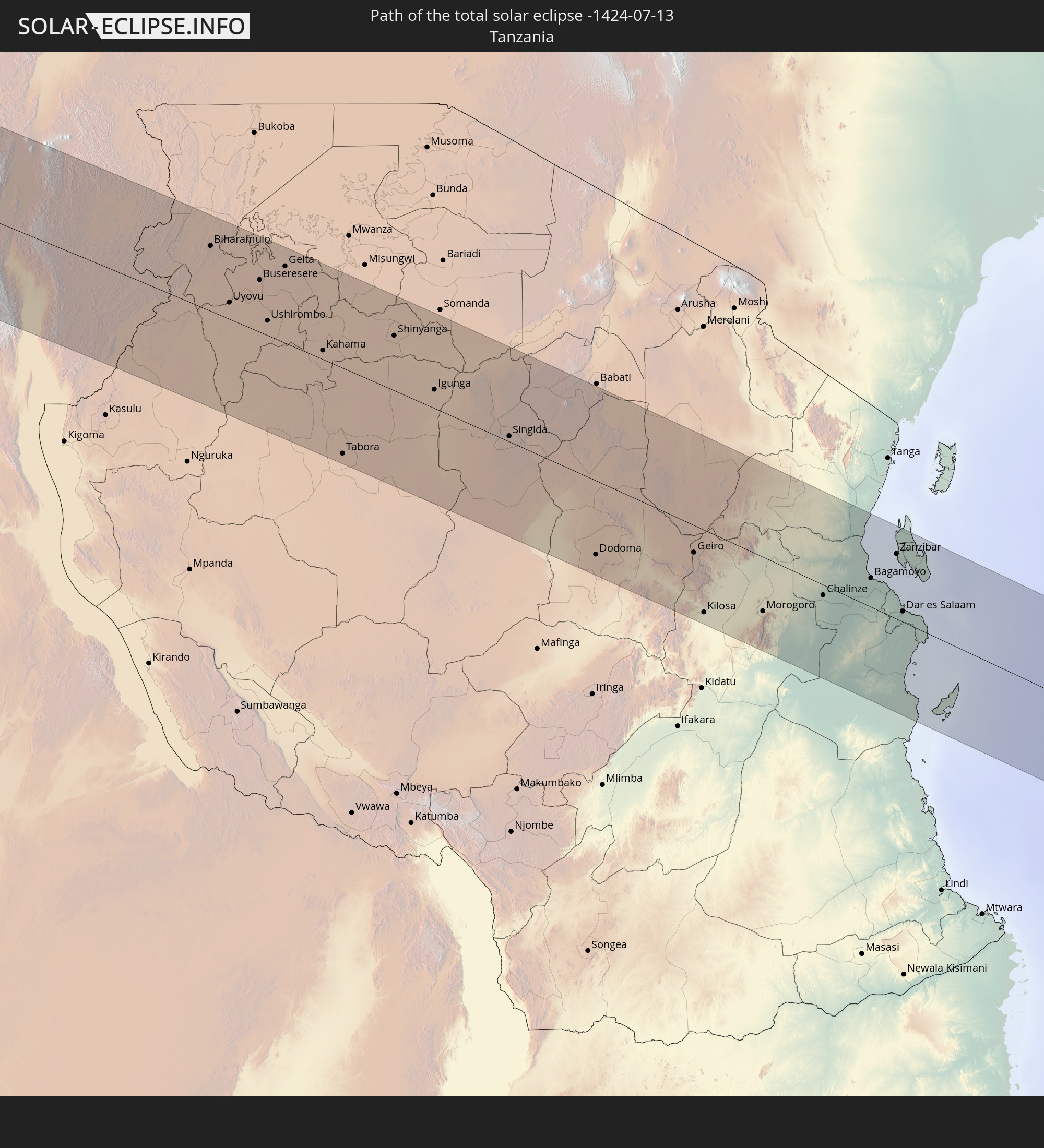 Tanzania
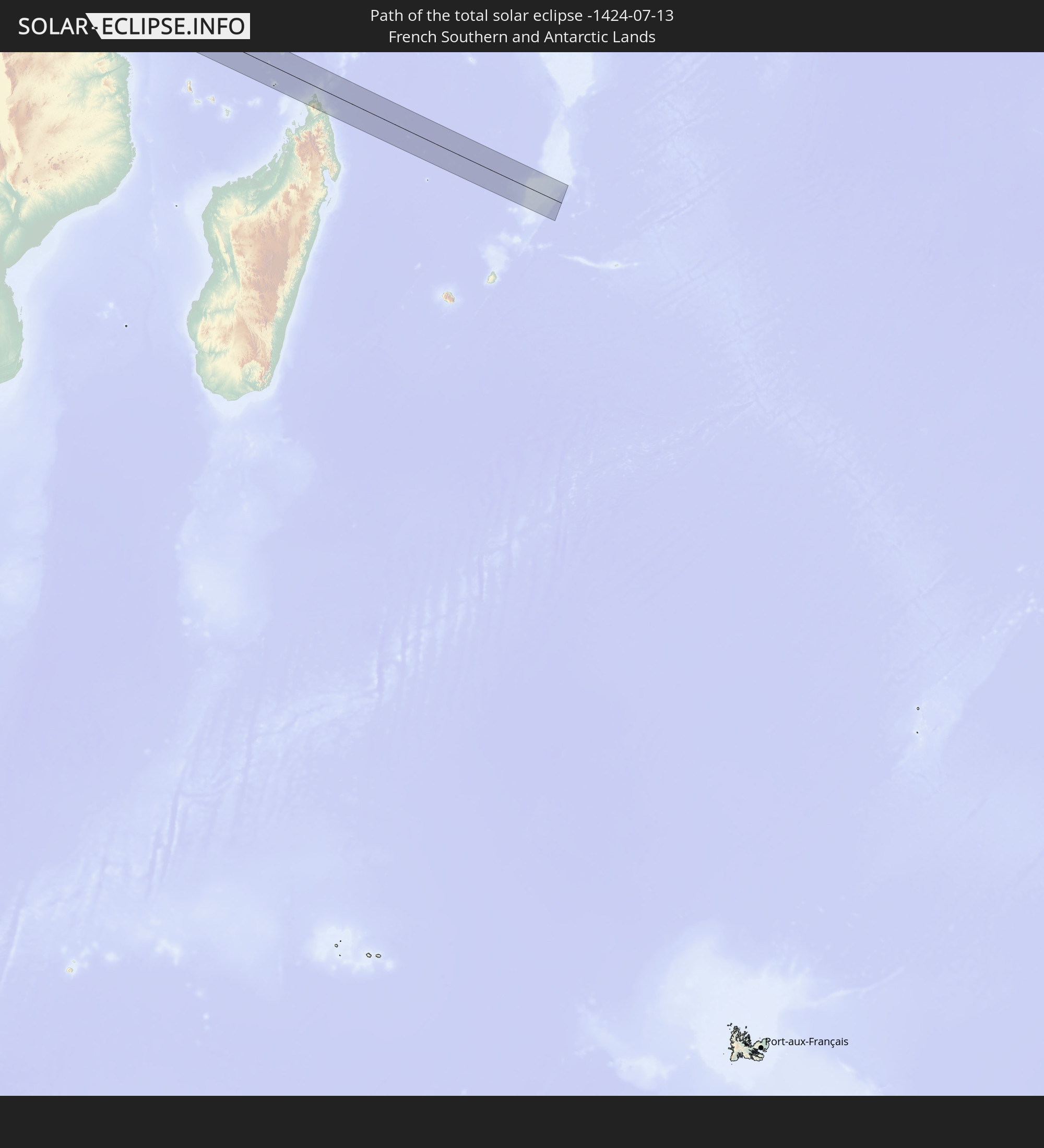 French Southern and Antarctic Lands
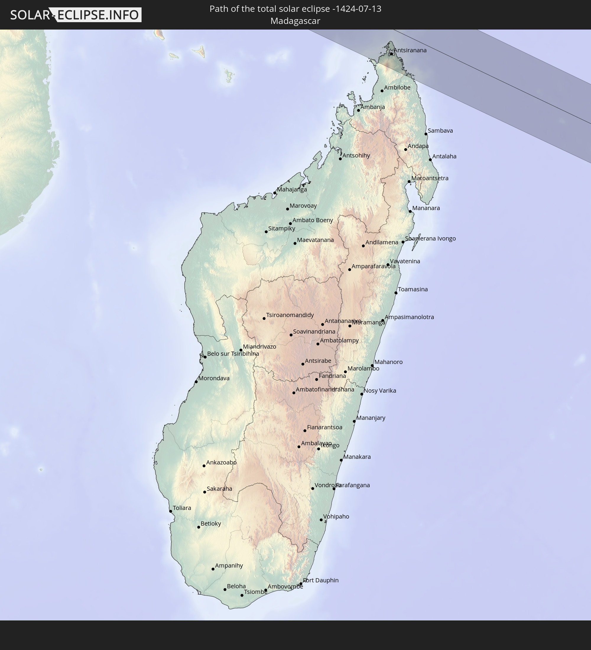 Madagascar
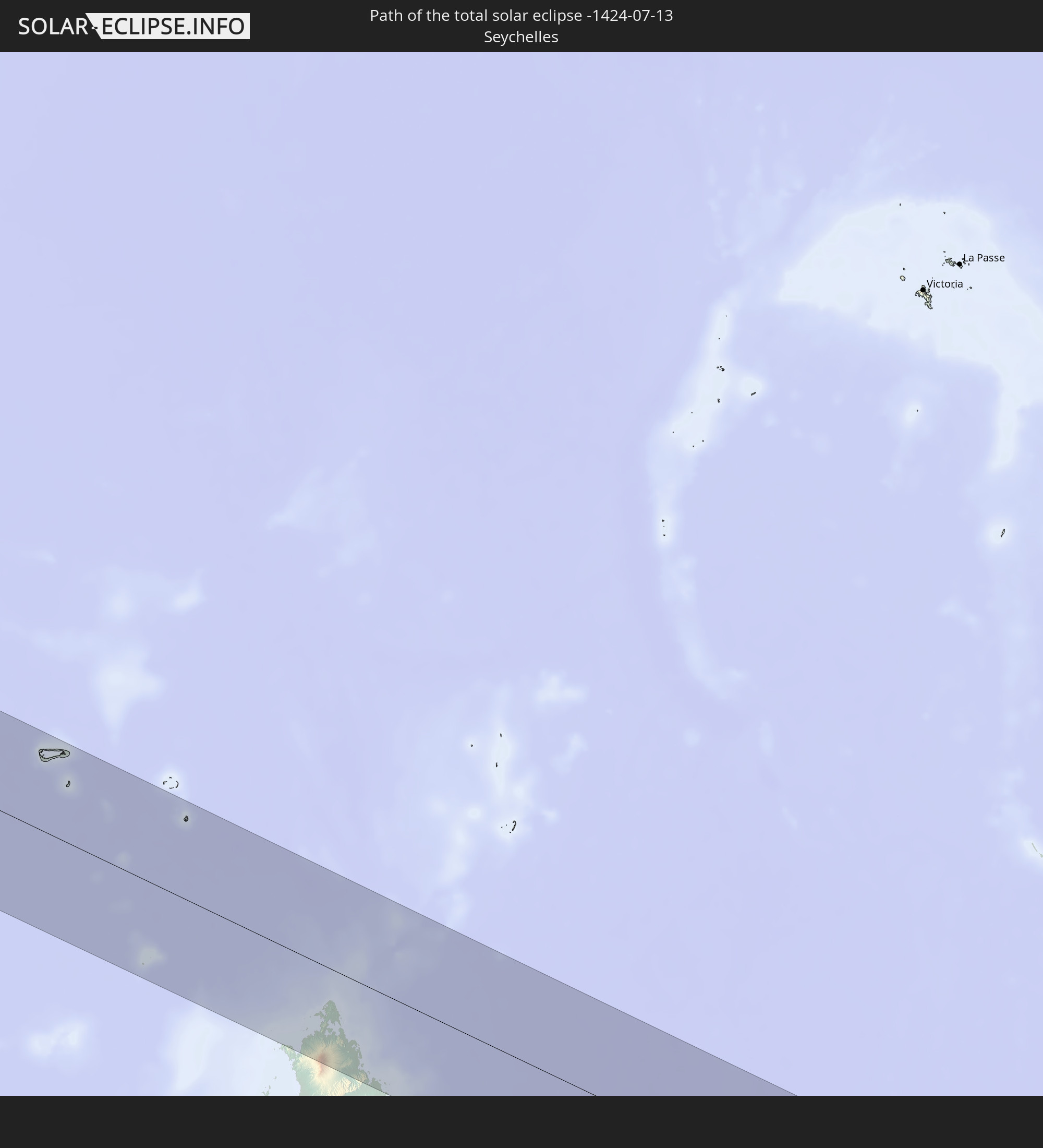 Seychelles
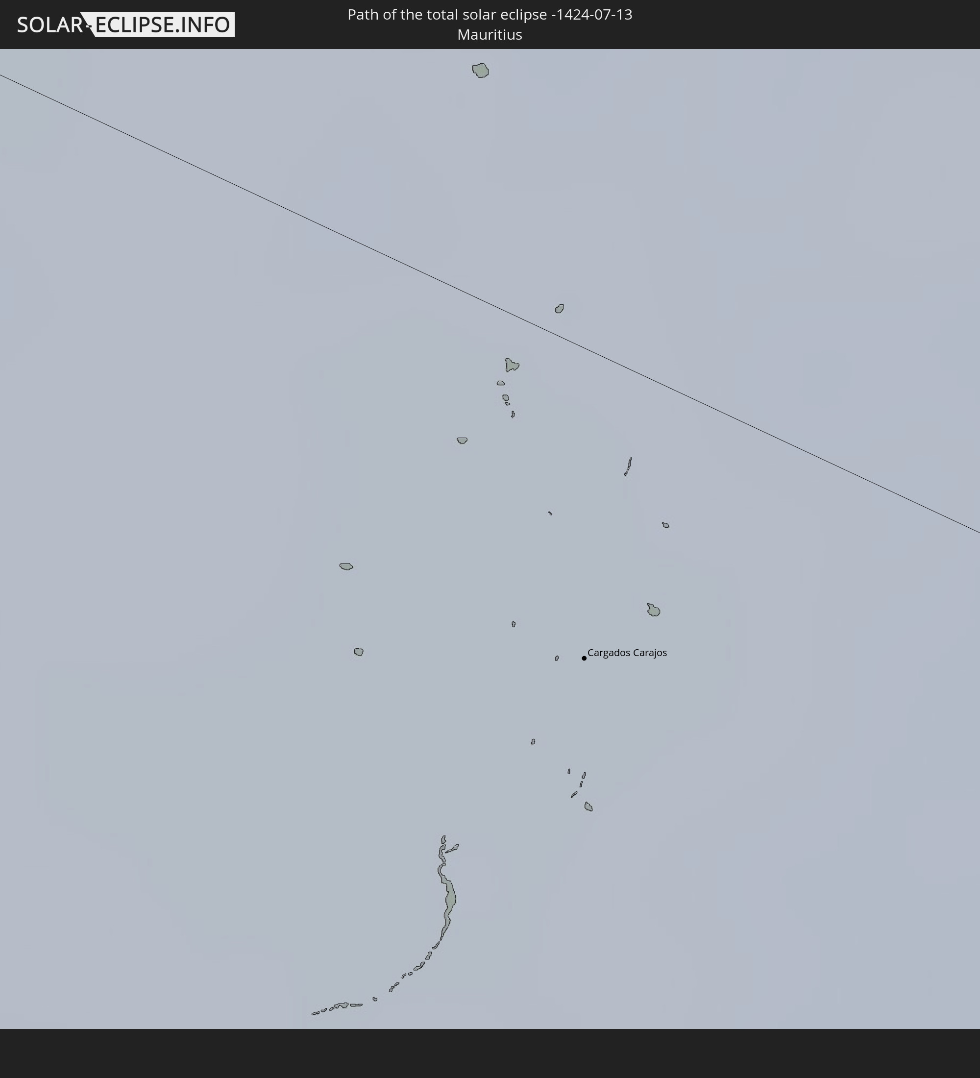 Mauritius
In den folgenden Ländern ist die Sonnenfinsternis partiell zu sehen
 Brazil
 Venezuela
 Guyana
 Suriname
 French Guiana
 South Georgia and the South Sandwich Islands
 Portugal
 Cabo Verde
 Spain
Spain
 Senegal
 Mauritania
 The Gambia
 Guinea-Bissau
 Guinea
 Saint Helena, Ascension and Tristan da Cunha
 Sierra Leone
 Morocco
 Mali
Mali
 Liberia
 Algeria
 Ivory Coast
 Burkina Faso
 Ghana
Ghana
 Togo
Togo
 Niger
Niger
 Benin
Benin
 Nigeria
 Equatorial Guinea
 São Tomé and Príncipe
 Tunisia
 Cameroon
 Gabon
Gabon
 Libya
Libya
 Republic of the Congo
 Angola
 Namibia
 Democratic Republic of the Congo
 Chad
Chad
 Central African Republic
 South Africa
 Botswana
 Sudan
Sudan
 Zambia
 Egypt
Egypt
 Zimbabwe
 Lesotho
 Rwanda
 Burundi
 Tanzania
 Uganda
 Mozambique
 Swaziland
 Malawi
 Ethiopia
 Kenya
Kenya
 Saudi Arabia
 Eritrea
 French Southern and Antarctic Lands
 Somalia
 Djibouti
 Yemen
Yemen
 Madagascar
 Comoros
 Mayotte
 Seychelles
 Oman
Oman
 Réunion
 Mauritius
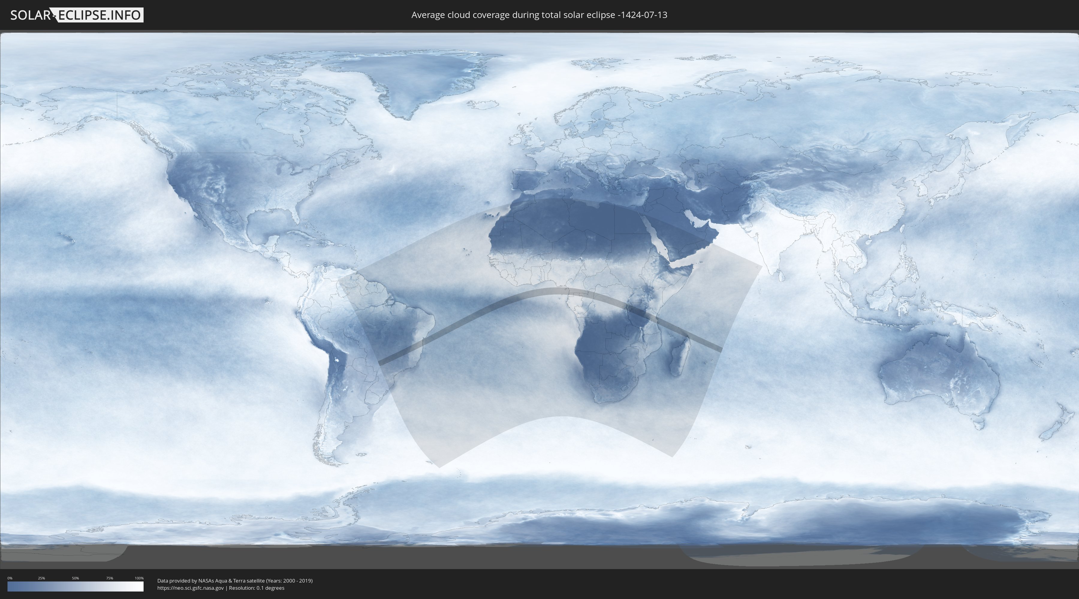
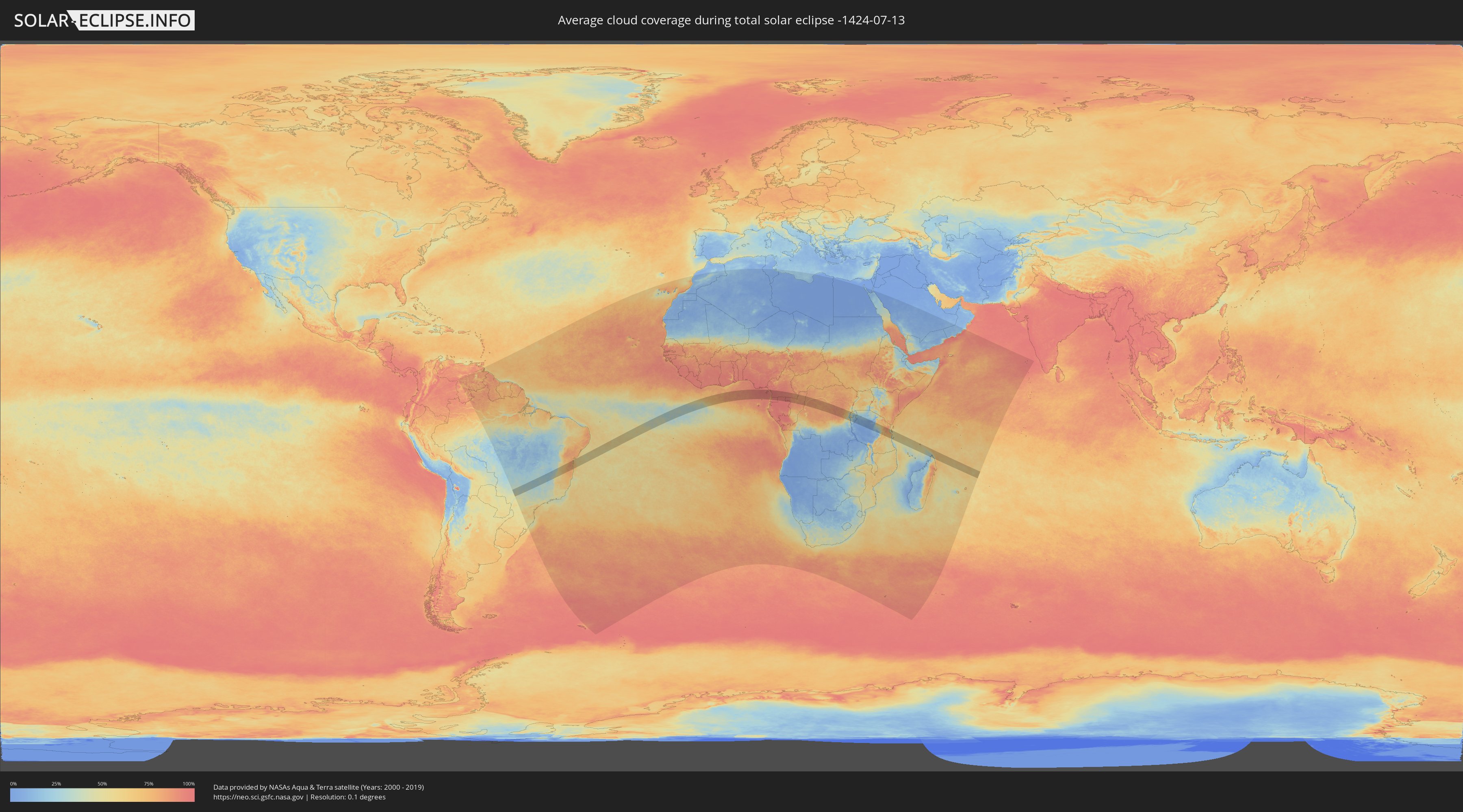
How will be the weather during the total solar eclipse on 07/13/-1424?
Where is the best place to see the total solar eclipse of 07/13/-1424?
The following maps show the average cloud coverage for the day of the total solar eclipse.
With the help of these maps, it is possible to find the place along the eclipse path, which has the best
chance of a cloudless sky.
Nevertheless, you should consider local circumstances and inform about the weather of your chosen
observation site.
The data is provided by NASAs satellites
AQUA and TERRA.
The cloud maps are averaged over a period of 19 years (2000 - 2019).
Detailed country maps
 Brazil
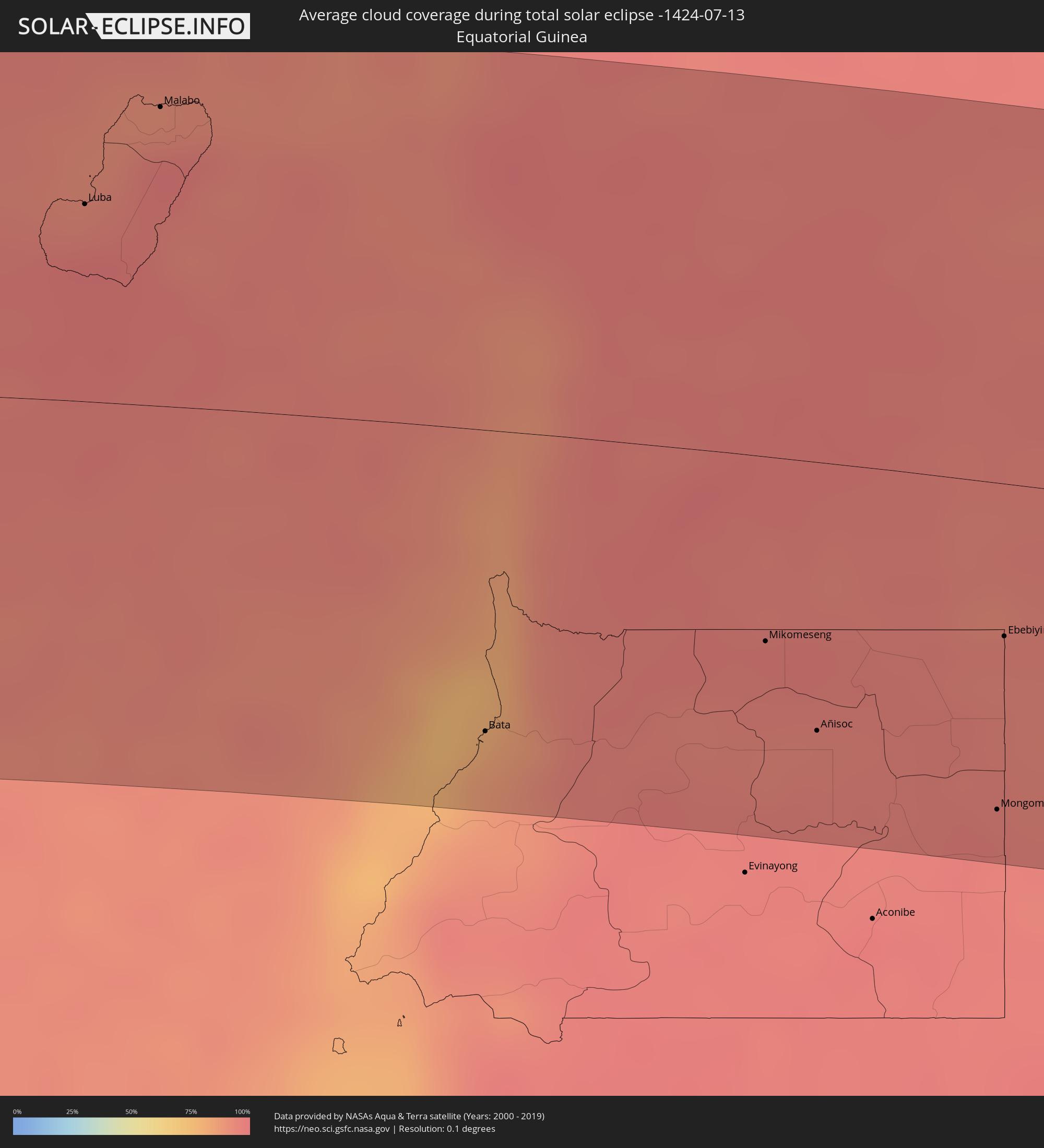 Equatorial Guinea
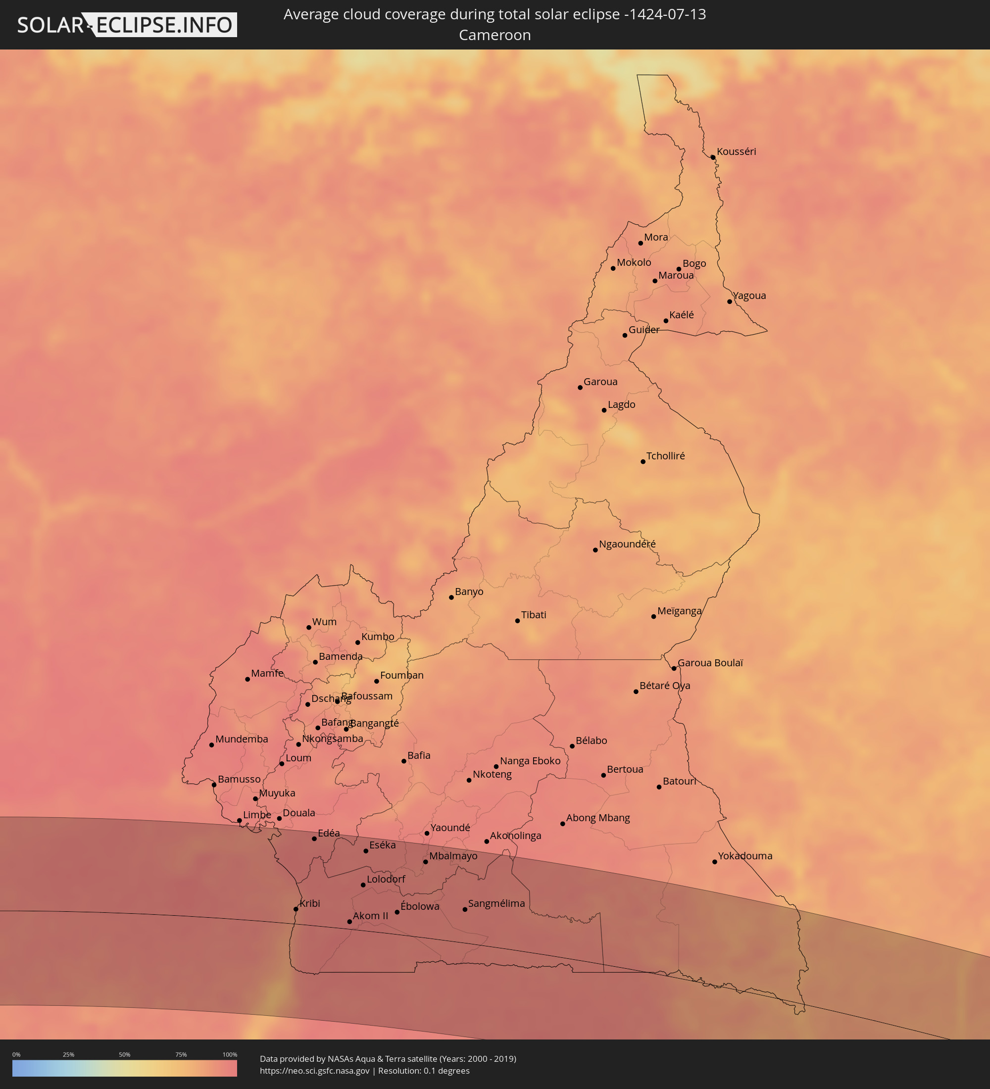 Cameroon
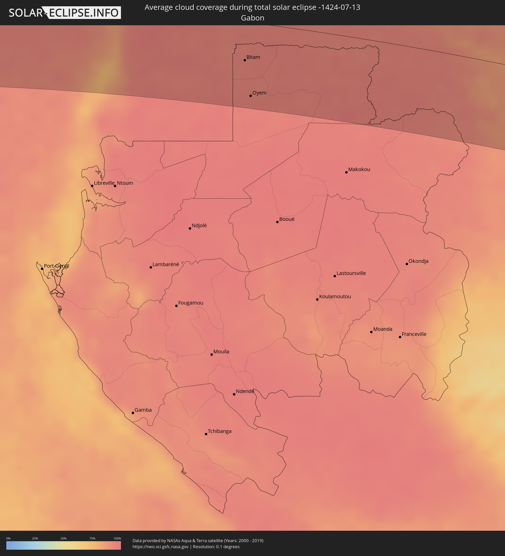 Gabon
Gabon
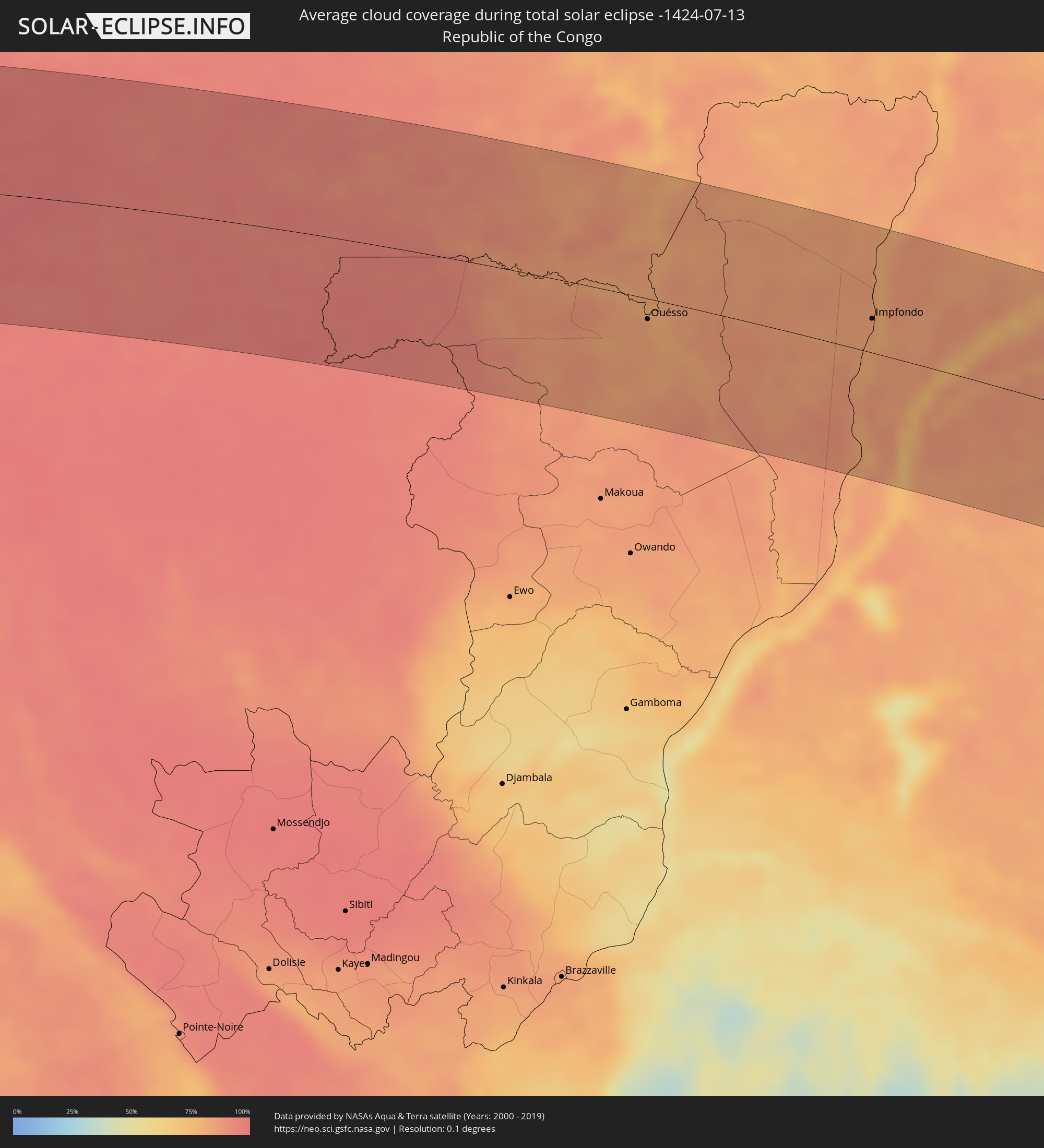 Republic of the Congo
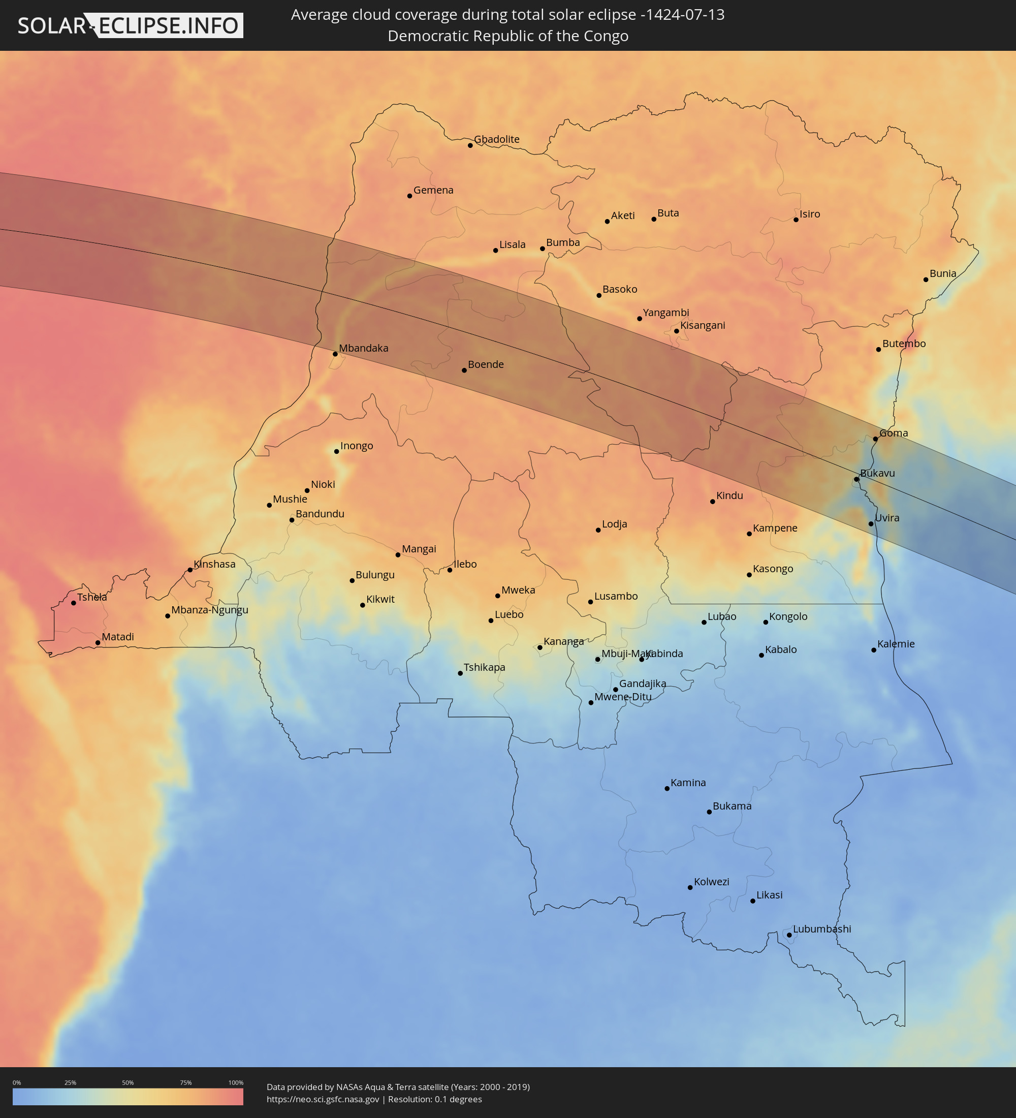 Democratic Republic of the Congo
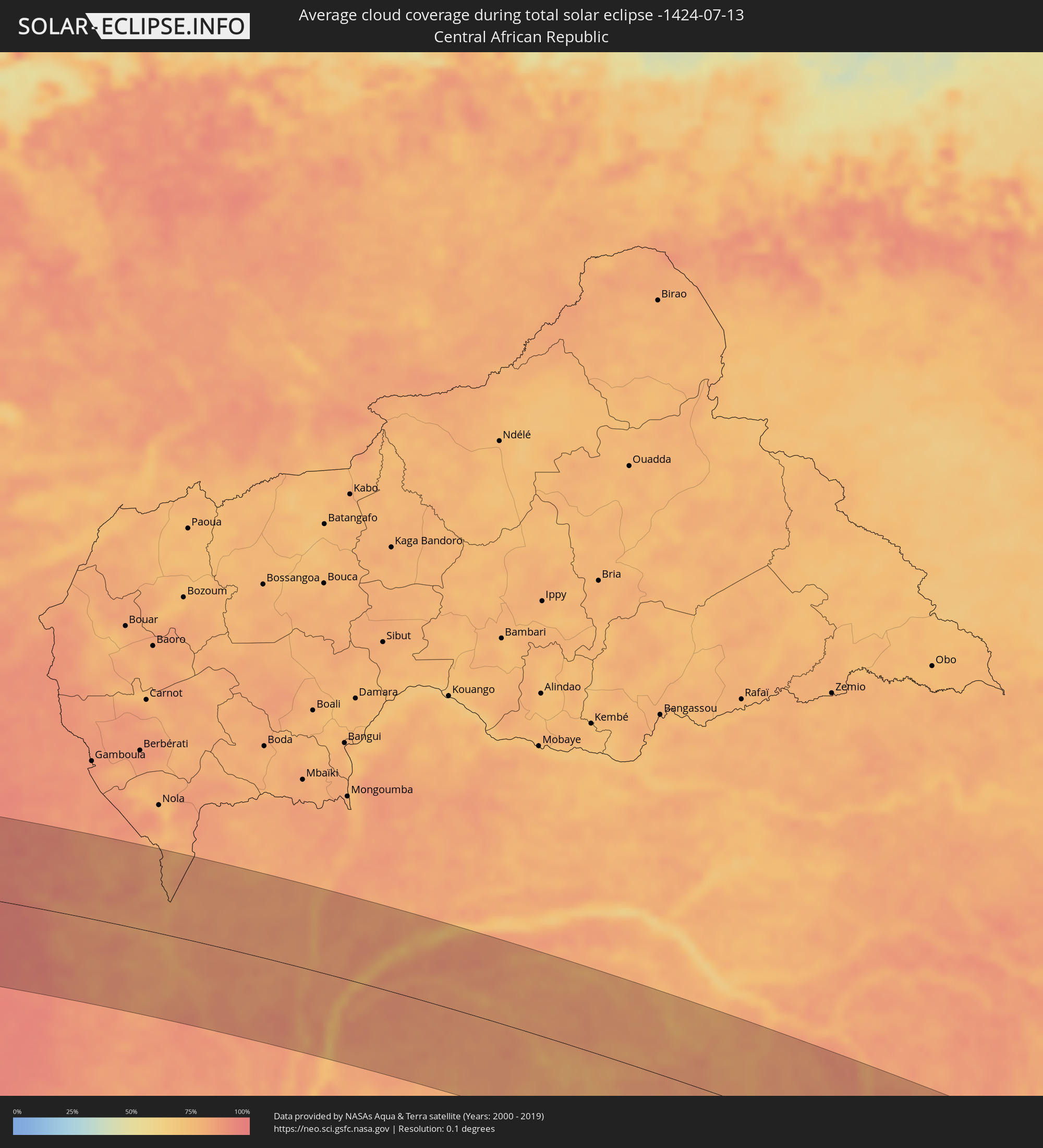 Central African Republic
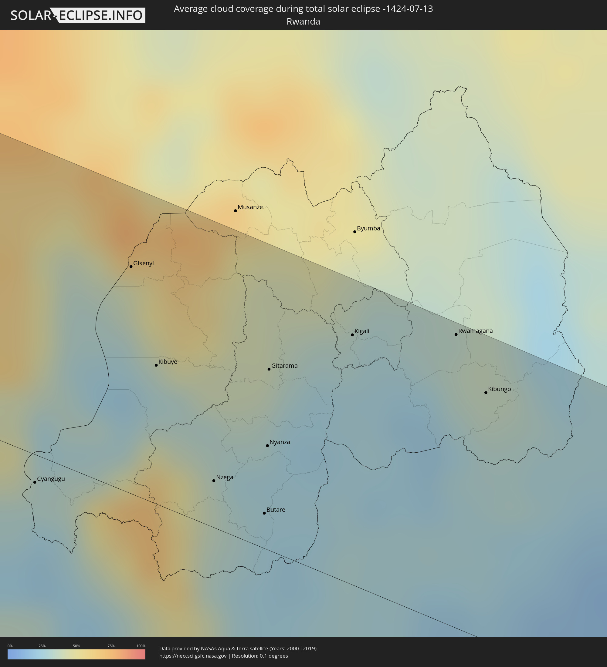 Rwanda
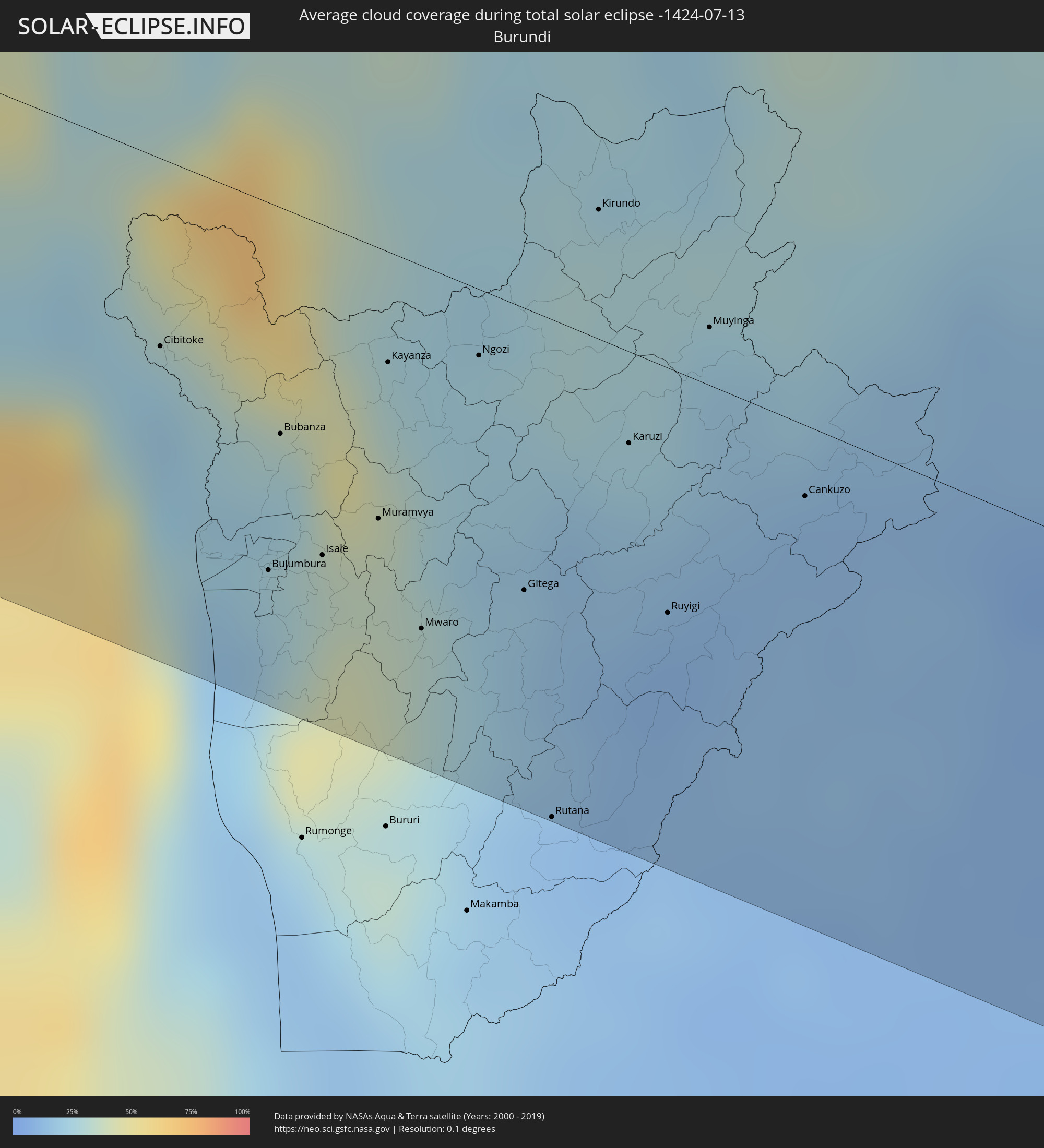 Burundi
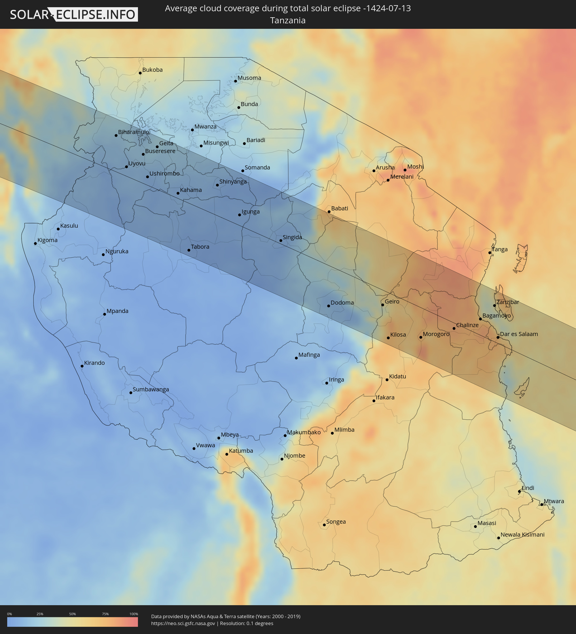 Tanzania
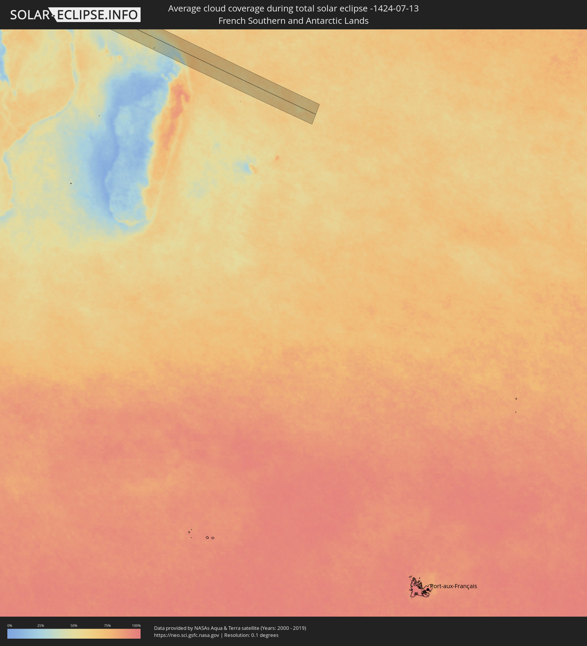 French Southern and Antarctic Lands
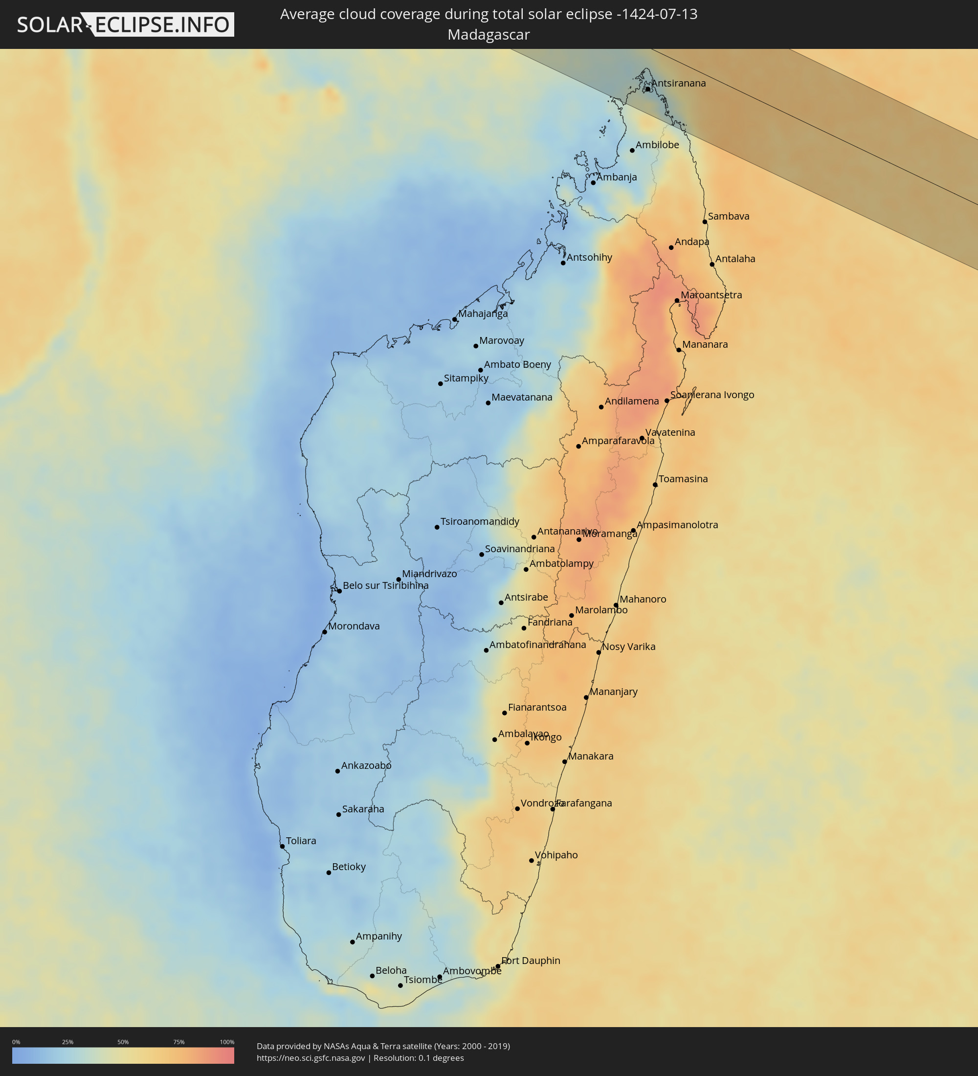 Madagascar
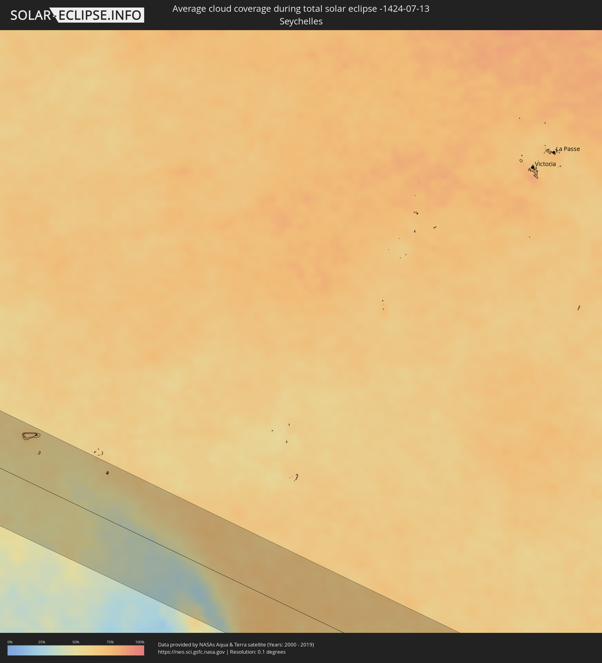 Seychelles
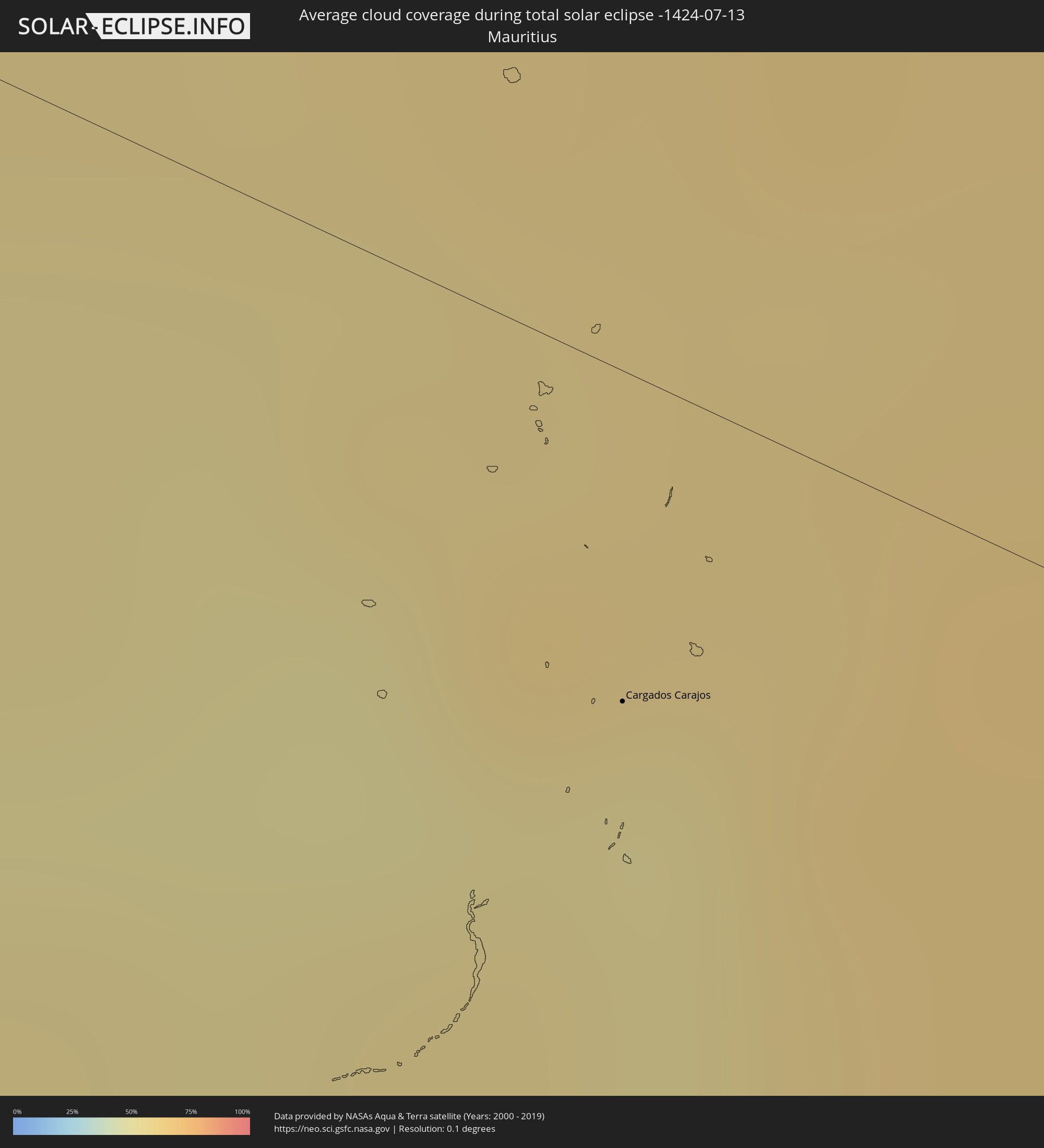 Mauritius
Cities inside the path of the eclipse
The following table shows all locations with a population of more than 5,000 inside the eclipse path. Cities which have more than 100,000 inhabitants are marked bold. A click at the locations opens a detailed map.
| City | Type | Eclipse duration | Local time of max. eclipse | Distance to central line | Ø Cloud coverage |
|
Três Lagoas, Mato Grosso do Sul
|
total | - | 06:32:58 UTC-03:38 | 24 km | 33% |
|
Andradina, São Paulo
|
total | - | 07:05:04 UTC-03:06 | 50 km | 38% |
|
Fernandópolis, São Paulo
|
total | - | 07:05:09 UTC-03:06 | 41 km | 31% |
|
Votuporanga, São Paulo
|
total | - | 07:05:16 UTC-03:06 | 67 km | 32% |
|
Ituiutaba, Minas Gerais
|
total | - | 07:05:02 UTC-03:06 | 53 km | 30% |
|
Uberlândia, Minas Gerais
|
total | - | 07:05:22 UTC-03:06 | 3 km | 27% |
|
Araguari, Minas Gerais
|
total | - | 07:05:20 UTC-03:06 | 26 km | 26% |
|
Catalão, Goiás
|
total | - | 07:05:19 UTC-03:06 | 63 km | 29% |
|
Uberaba, Minas Gerais
|
total | - | 07:05:41 UTC-03:06 | 95 km | 29% |
|
Monte Carmelo, Minas Gerais
|
total | - | 07:05:35 UTC-03:06 | 14 km | 27% |
|
Patrocínio, Minas Gerais
|
total | - | 07:05:49 UTC-03:06 | 60 km | 31% |
|
Patos de Minas, Minas Gerais
|
total | - | 07:05:54 UTC-03:06 | 46 km | 29% |
|
Pirapora, Minas Gerais
|
total | - | 07:06:20 UTC-03:06 | 1 km | 26% |
|
Montes Claros, Minas Gerais
|
total | - | 07:06:44 UTC-03:06 | 9 km | 33% |
|
Janaúba, Minas Gerais
|
total | - | 07:06:54 UTC-03:06 | 74 km | 32% |
|
Vitória da Conquista, Bahia
|
total | - | 07:40:41 UTC-02:34 | 45 km | 72% |
|
Itapetinga, Bahia
|
total | - | 07:41:04 UTC-02:34 | 22 km | 76% |
|
Itabuna, Bahia
|
total | - | 07:41:41 UTC-02:34 | 25 km | 80% |
|
Ilhéus, Bahia
|
total | - | 07:41:51 UTC-02:34 | 38 km | 63% |
|
Luba, Bioko Sur
|
total | - | 12:17:35 UTC+00:13 | 66 km | 95% |
|
Malabo, Bioko Norte
|
total | - | 12:18:18 UTC+00:13 | 100 km | 91% |
|
Rebola, Bioko Norte
|
total | - | 12:18:28 UTC+00:13 | 97 km | 97% |
|
Bata, Litoral
|
total | - | 12:21:22 UTC+00:13 | 101 km | 84% |
|
Kribi, South
|
total | - | 12:21:48 UTC+00:13 | 19 km | 88% |
|
Dizangué, Littoral
|
total | - | 12:22:01 UTC+00:13 | 112 km | 96% |
|
Edéa, Littoral
|
total | - | 12:22:29 UTC+00:13 | 117 km | 96% |
|
Akom II, South
|
total | - | 12:23:51 UTC+00:13 | 9 km | 97% |
|
Mikomeseng, Kié-Ntem
|
total | - | 12:24:01 UTC+00:13 | 62 km | 96% |
|
Lolodorf, South
|
total | - | 12:24:20 UTC+00:13 | 61 km | 97% |
|
Eséka, Centre
|
total | - | 12:24:25 UTC+00:13 | 108 km | 96% |
|
Añisoc, Wele-Nzas
|
total | - | 12:24:30 UTC+00:13 | 90 km | 94% |
|
Ébolowa, South
|
total | - | 12:25:38 UTC+00:13 | 29 km | 95% |
|
Ambam, South
|
total | - | 12:26:04 UTC+00:13 | 26 km | 94% |
|
Mongomo, Wele-Nzas
|
total | - | 12:26:12 UTC+00:13 | 109 km | 97% |
|
Ebebiyin, Kié-Ntem
|
total | - | 12:26:14 UTC+00:13 | 51 km | 95% |
|
Mbalmayo, Centre
|
total | - | 12:26:39 UTC+00:13 | 102 km | 94% |
|
Bitam, Woleu-Ntem
|
total | - | 12:26:45 UTC+00:13 | 57 km | 94% |
|
Oyem, Woleu-Ntem
|
total | - | 12:27:01 UTC+00:13 | 108 km | 96% |
|
Sangmélima, South
|
total | - | 12:28:09 UTC+00:13 | 45 km | 94% |
|
Ouésso, Sangha
|
total | - | 12:40:06 UTC+00:13 | 20 km | 80% |
|
Impfondo, Likouala
|
total | - | 12:45:31 UTC+00:13 | 33 km | 79% |
|
Boende, Équateur
|
total | - | 12:53:03 UTC+00:13 | 85 km | 81% |
|
Kabare, South Kivu
|
total | - | 15:07:00 UTC+02:10 | 17 km | 29% |
|
Bukavu, South Kivu
|
total | - | 15:07:06 UTC+02:10 | 14 km | 29% |
|
Cyangugu, Western Province
|
total | - | 15:07:13 UTC+02:10 | 11 km | 25% |
|
Sake, Nord Kivu
|
total | - | 15:07:15 UTC+02:10 | 89 km | 35% |
|
Cibitoke, Cibitoke
|
total | - | 15:07:41 UTC+02:10 | 43 km | 20% |
|
Uvira, South Kivu
|
total | - | 15:07:48 UTC+02:10 | 95 km | 41% |
|
Goma, Nord Kivu
|
total | - | 15:07:37 UTC+02:10 | 87 km | 37% |
|
Gisenyi, Western Province
|
total | - | 15:07:40 UTC+02:10 | 85 km | 50% |
|
Kibuye, Western Province
|
total | - | 15:07:54 UTC+02:10 | 52 km | 33% |
|
Bujumbura, Bujumbura Mairie
|
total | - | 15:08:12 UTC+02:10 | 84 km | 29% |
|
Bubanza, Bubanza
|
total | - | 15:08:12 UTC+02:10 | 52 km | 26% |
|
Isale, Bujumbura Rural
|
total | - | 15:08:24 UTC+02:10 | 75 km | 36% |
|
Nzega, Southern Province
|
total | - | 15:08:22 UTC+02:10 | 17 km | 31% |
|
Muramvya, Muramvya
|
total | - | 15:08:37 UTC+02:10 | 62 km | 35% |
|
Kayanza, Kayanza
|
total | - | 15:08:35 UTC+02:10 | 25 km | 31% |
|
Mwaro, Mwaro
|
total | - | 15:08:49 UTC+02:10 | 83 km | 30% |
|
Butare, Southern Province
|
total | - | 15:08:42 UTC+02:10 | 13 km | 26% |
|
Nyanza, Southern Province
|
total | - | 15:08:41 UTC+02:10 | 39 km | 26% |
|
Gitarama, Southern Province
|
total | - | 15:08:38 UTC+02:10 | 67 km | 26% |
|
Ngozi, Ngozi
|
total | - | 15:08:56 UTC+02:10 | 15 km | 24% |
|
Gitega, Gitega
|
total | - | 15:09:12 UTC+02:10 | 64 km | 18% |
|
Rutana, Rutana
|
total | - | 15:09:23 UTC+02:10 | 113 km | 12% |
|
Kigali, Kigali
|
total | - | 15:09:07 UTC+02:10 | 93 km | 27% |
|
Kirundo, Kirundo
|
total | - | 15:09:19 UTC+02:10 | 29 km | 28% |
|
Karuzi, Karuzi
|
total | - | 15:09:32 UTC+02:10 | 21 km | 19% |
|
Ruyigi, Ruyigi
|
total | - | 15:09:45 UTC+02:10 | 56 km | 9% |
|
Muyinga, Muyinga
|
total | - | 15:09:47 UTC+02:10 | 13 km | 21% |
|
Rwamagana, Eastern Province
|
total | - | 15:09:45 UTC+02:10 | 109 km | 35% |
|
Kibungo, Eastern Province
|
total | - | 15:09:59 UTC+02:10 | 92 km | 30% |
|
Cankuzo, Cankuzo
|
total | - | 15:10:13 UTC+02:10 | 16 km | 12% |
|
Biharamulo, Kagera
|
total | - | 15:28:17 UTC+02:27 | 77 km | 18% |
|
Uyovu, Geita
|
total | - | 15:28:45 UTC+02:27 | 19 km | 12% |
|
Buseresere, Geita
|
total | - | 15:29:16 UTC+02:27 | 61 km | 19% |
|
Ushirombo, Geita
|
total | - | 15:29:30 UTC+02:27 | 17 km | 8% |
|
Geita, Geita
|
total | - | 15:29:41 UTC+02:27 | 90 km | 18% |
|
Masumbwe, Geita
|
total | - | 15:29:52 UTC+02:27 | 12 km | 9% |
|
Kahama, Shinyanga
|
total | - | 15:30:32 UTC+02:27 | 10 km | 11% |
|
Tabora, Tabora
|
total | - | 15:31:03 UTC+02:27 | 100 km | 4% |
|
Shinyanga, Shinyanga
|
total | - | 15:31:44 UTC+02:27 | 64 km | 7% |
|
Igunga, Tabora
|
total | - | 15:32:31 UTC+02:27 | 22 km | 6% |
|
Singida, Singida
|
total | - | 15:33:48 UTC+02:27 | 6 km | 7% |
|
Dodoma, Dodoma
|
total | - | 15:35:18 UTC+02:27 | 86 km | 14% |
|
Geiro, Morogoro
|
total | - | 15:36:45 UTC+02:27 | 32 km | 48% |
|
Kilosa, Morogoro
|
total | - | 15:36:56 UTC+02:27 | 95 km | 73% |
|
Morogoro, Morogoro
|
total | - | 15:37:46 UTC+02:27 | 63 km | 76% |
|
Chalinze, Pwani
|
total | - | 15:38:34 UTC+02:27 | 12 km | 78% |
|
Bagamoyo, Pwani
|
total | - | 15:39:10 UTC+02:27 | 33 km | 74% |
|
Zanzibar, Zanzibar Urban/West
|
total | - | 15:39:29 UTC+02:27 | 75 km | 40% |
|
Dar es Salaam, Dar es Salaam
|
total | - | 15:39:36 UTC+02:27 | 12 km | 67% |
|
Antsiranana, Diana
|
total | - | 15:47:37 UTC+02:27 | 64 km | 34% |
|
Sadjoavato, Diana
|
total | - | 15:47:35 UTC+02:27 | 95 km | 54% |
|
Cargados Carajos, Cargados Carajos
|
total | - | 17:13:09 UTC+03:50 | 19 km | 52% |