Total solar eclipse of 01/26/-1517
| Day of week: | Sunday |
| Maximum duration of eclipse: | 02m56s |
| Maximum width of eclipse path: | 134 km |
| Saros cycle: | 26 |
| Coverage: | 100% |
| Magnitude: | 1.0364 |
| Gamma: | -0.4084 |
Wo kann man die Sonnenfinsternis vom 01/26/-1517 sehen?
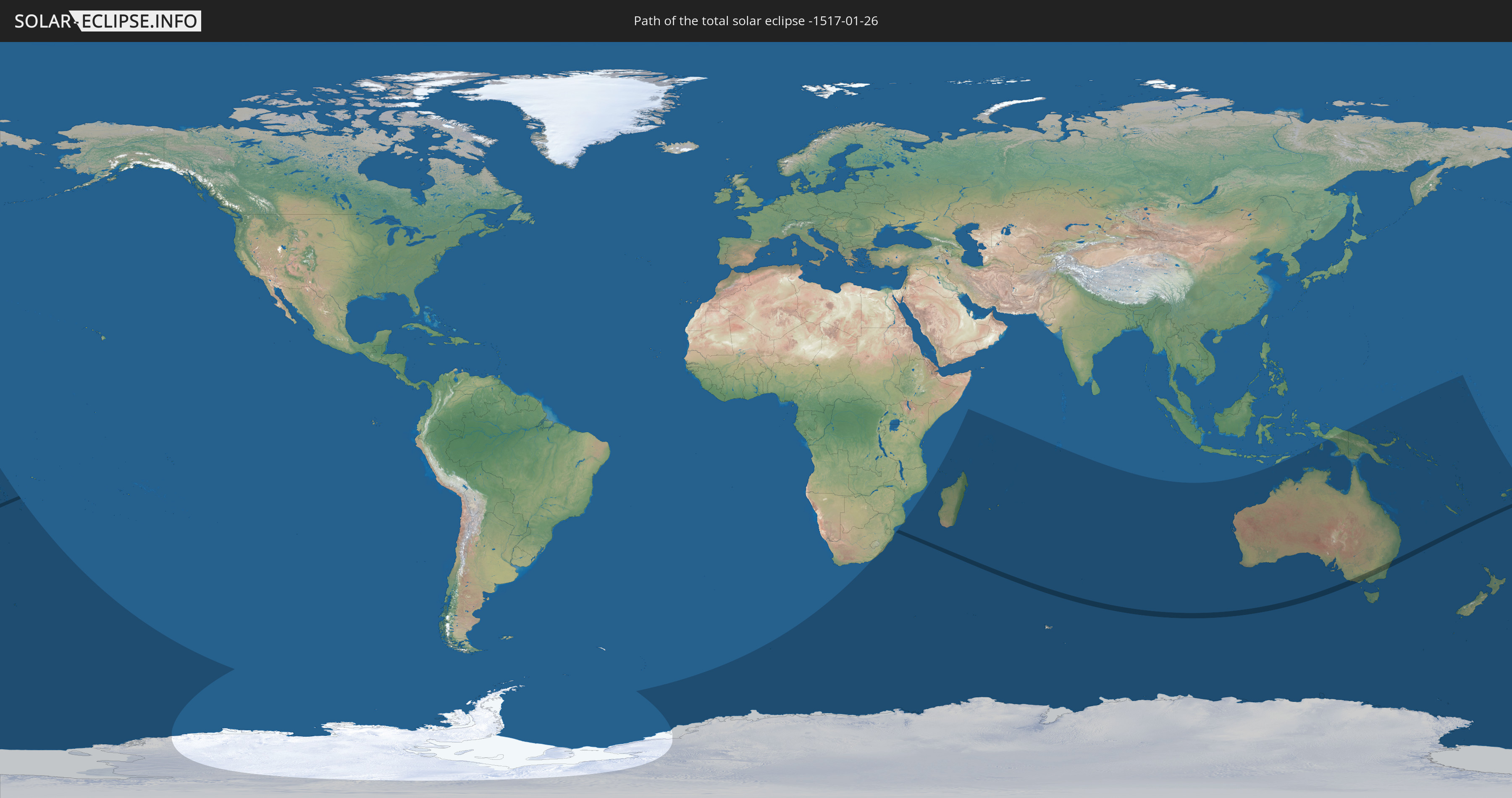
Die Sonnenfinsternis am 01/26/-1517 kann man in 29 Ländern als partielle Sonnenfinsternis beobachten.
Der Finsternispfad verläuft durch 2 Länder. Nur in diesen Ländern ist sie als total Sonnenfinsternis zu sehen.
In den folgenden Ländern ist die Sonnenfinsternis total zu sehen
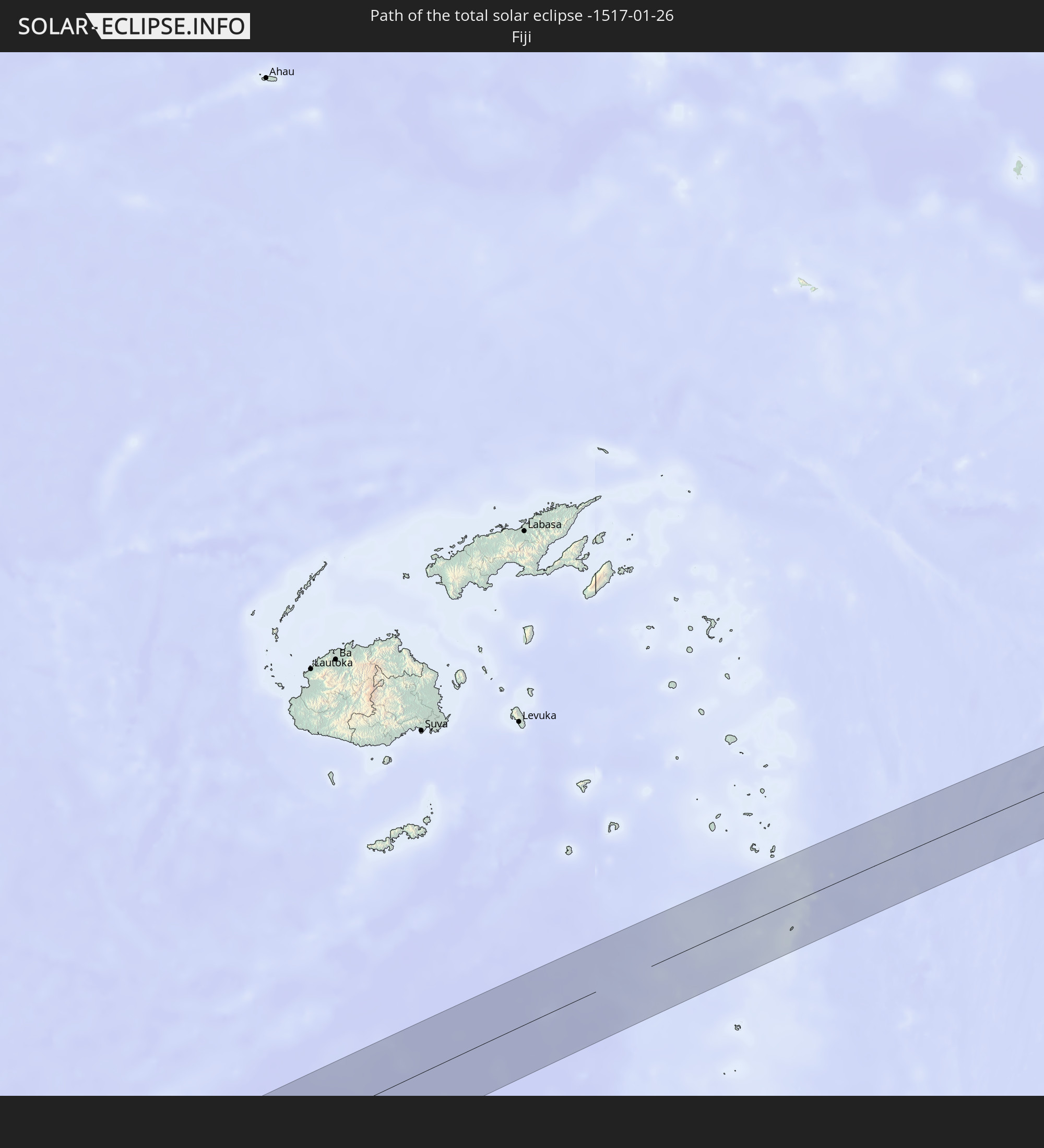 Fiji
Fiji
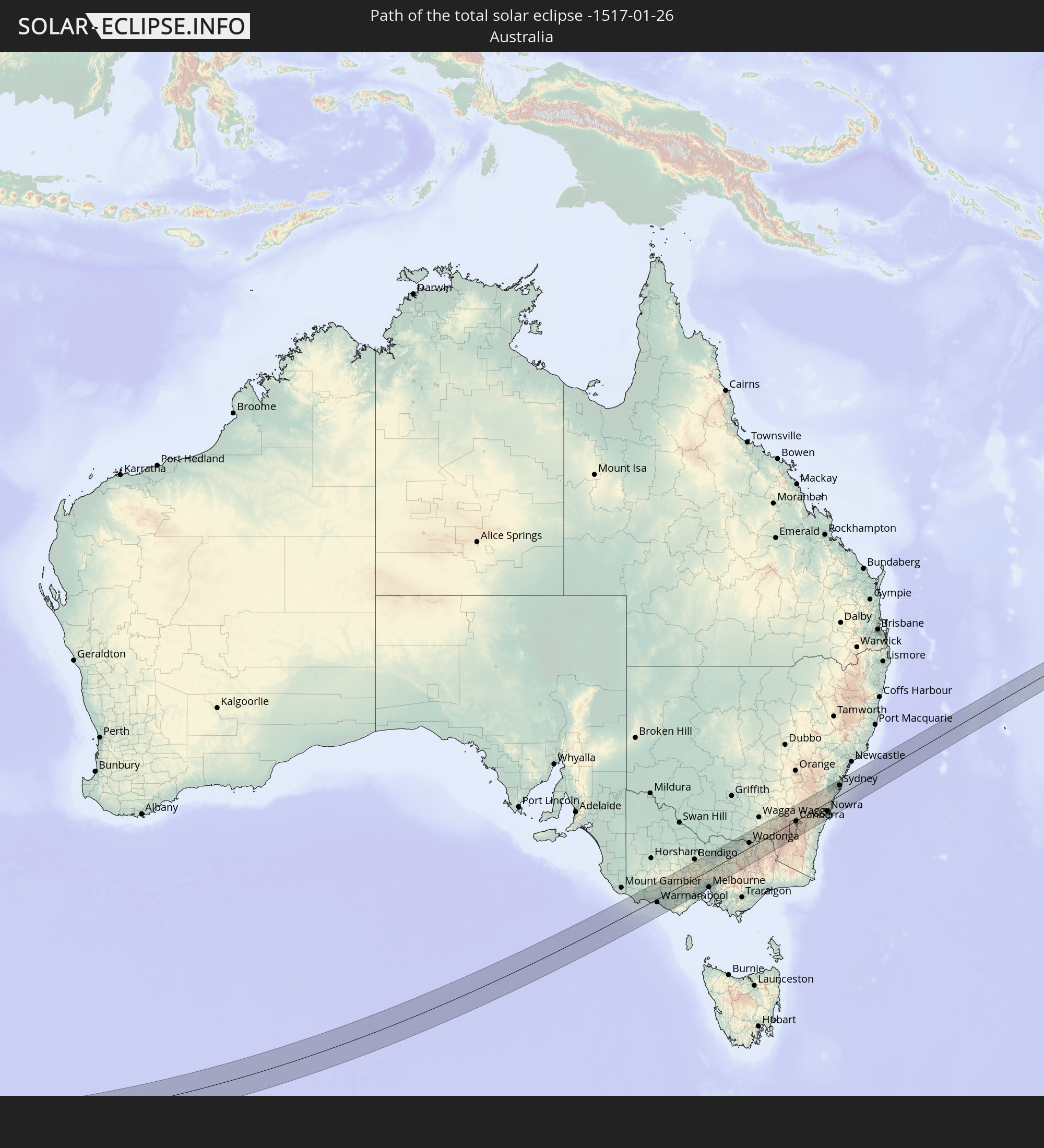 Australia
In den folgenden Ländern ist die Sonnenfinsternis partiell zu sehen
 Fiji
Fiji
 Antarctica
 New Zealand
 Wallis and Futuna
 Tonga
Tonga
 Kiribati
 Bouvet Island
 South Africa
 Mozambique
 French Southern and Antarctic Lands
 Madagascar
 Comoros
 Mayotte
 Seychelles
 Réunion
 Mauritius
 British Indian Ocean Territory
 Heard Island and McDonald Islands
 Indonesia
 Australia
 Federated States of Micronesia
 Papua New Guinea
 Solomon Islands
 New Caledonia
 Marshall Islands
 Vanuatu
 Nauru
Nauru
 Norfolk Island
 Tuvalu
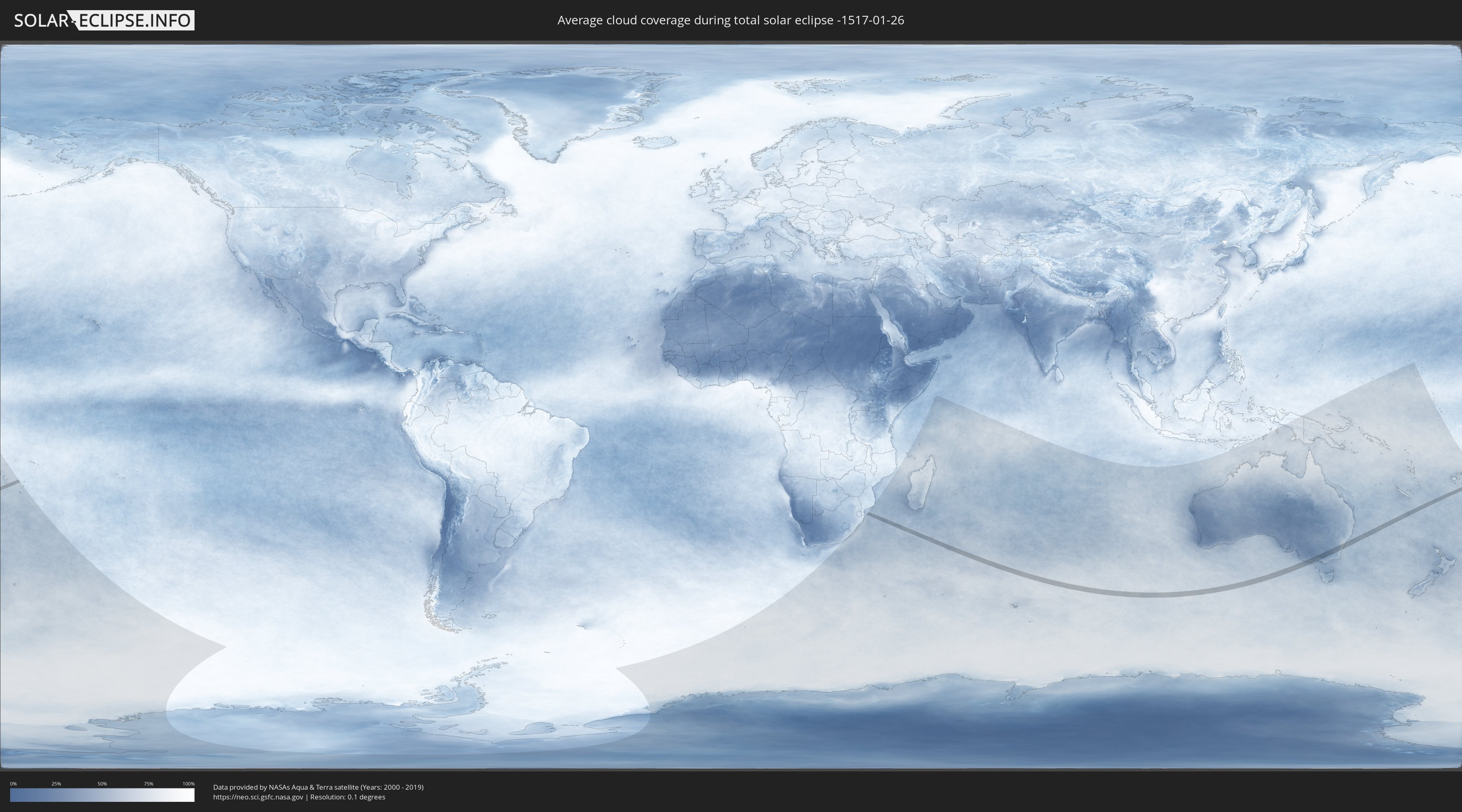
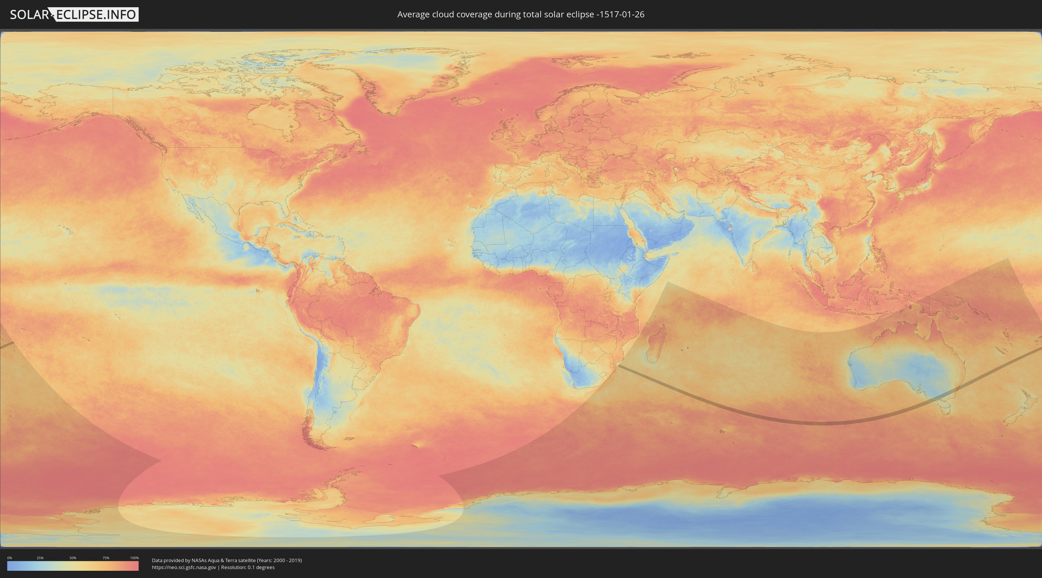
How will be the weather during the total solar eclipse on 01/26/-1517?
Where is the best place to see the total solar eclipse of 01/26/-1517?
The following maps show the average cloud coverage for the day of the total solar eclipse.
With the help of these maps, it is possible to find the place along the eclipse path, which has the best
chance of a cloudless sky.
Nevertheless, you should consider local circumstances and inform about the weather of your chosen
observation site.
The data is provided by NASAs satellites
AQUA and TERRA.
The cloud maps are averaged over a period of 19 years (2000 - 2019).
Detailed country maps
 Fiji
Fiji
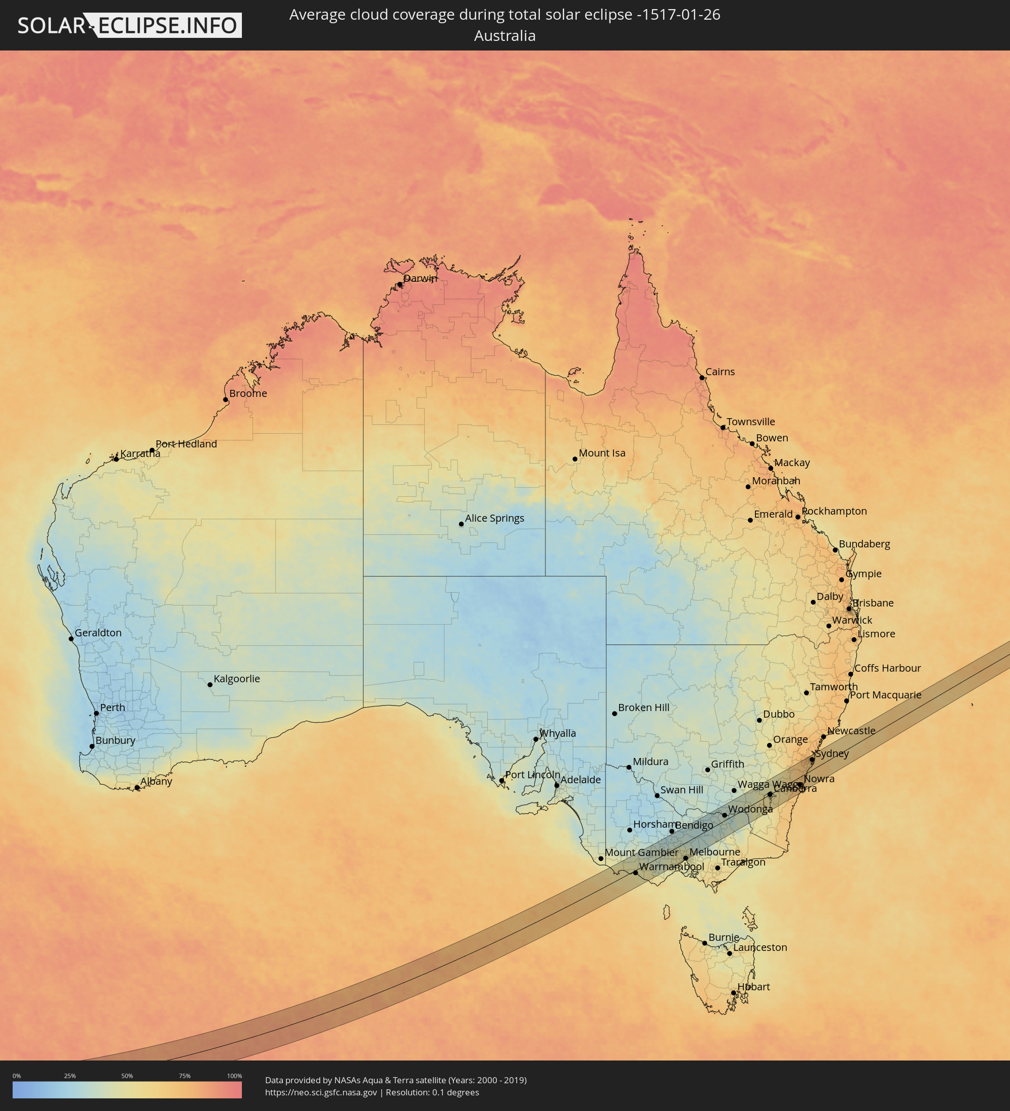 Australia
Cities inside the path of the eclipse
The following table shows all locations with a population of more than 5,000 inside the eclipse path. Cities which have more than 100,000 inhabitants are marked bold. A click at the locations opens a detailed map.
| City | Type | Eclipse duration | Local time of max. eclipse | Distance to central line | Ø Cloud coverage |
|
Portland, Victoria
|
total | - | 15:47:06 UTC+10:00 | 28 km | 57% |
|
Warrnambool, Victoria
|
total | - | 15:48:06 UTC+10:00 | 12 km | 48% |
|
Colac, Victoria
|
total | - | 15:49:26 UTC+10:00 | 54 km | 46% |
|
Sebastopol, Victoria
|
total | - | 15:50:52 UTC+10:00 | 8 km | 41% |
|
Ballarat, Victoria
|
total | - | 15:50:54 UTC+10:00 | 10 km | 41% |
|
Ballarat Central, Victoria
|
total | - | 15:50:55 UTC+10:00 | 10 km | 41% |
|
Castlemaine, Victoria
|
total | - | 15:52:04 UTC+10:00 | 43 km | 34% |
|
Lara, Victoria
|
total | - | 15:50:50 UTC+10:00 | 59 km | 47% |
|
Bacchus Marsh, Victoria
|
total | - | 15:51:24 UTC+10:00 | 26 km | 48% |
|
Melton West, Victoria
|
total | - | 15:51:32 UTC+10:00 | 32 km | 48% |
|
Melton South, Victoria
|
total | - | 15:51:30 UTC+10:00 | 35 km | 48% |
|
Melton, Victoria
|
total | - | 15:51:32 UTC+10:00 | 33 km | 48% |
|
Kurunjang, Victoria
|
total | - | 15:51:34 UTC+10:00 | 33 km | 48% |
|
Hoppers Crossing, Victoria
|
total | - | 15:51:22 UTC+10:00 | 57 km | 49% |
|
Sunbury, Victoria
|
total | - | 15:51:51 UTC+10:00 | 29 km | 48% |
|
Caroline Springs, Victoria
|
total | - | 15:51:37 UTC+10:00 | 45 km | 48% |
|
Hillside, Victoria
|
total | - | 15:51:42 UTC+10:00 | 41 km | 48% |
|
Truganina, Victoria
|
total | - | 15:51:31 UTC+10:00 | 53 km | 48% |
|
Taylors Hill, Victoria
|
total | - | 15:51:41 UTC+10:00 | 43 km | 49% |
|
Sydenham, Victoria
|
total | - | 15:51:43 UTC+10:00 | 43 km | 49% |
|
Derrimut, Victoria
|
total | - | 15:51:35 UTC+10:00 | 52 km | 48% |
|
Delahey, Victoria
|
total | - | 15:51:42 UTC+10:00 | 45 km | 49% |
|
Deer Park, Victoria
|
total | - | 15:51:38 UTC+10:00 | 50 km | 48% |
|
Taylors Lakes, Victoria
|
total | - | 15:51:44 UTC+10:00 | 43 km | 49% |
|
Cairnlea, Victoria
|
total | - | 15:51:39 UTC+10:00 | 49 km | 48% |
|
Saint Albans, Victoria
|
total | - | 15:51:42 UTC+10:00 | 47 km | 49% |
|
Keilor Downs, Victoria
|
total | - | 15:51:43 UTC+10:00 | 47 km | 49% |
|
Sunshine West, Victoria
|
total | - | 15:51:38 UTC+10:00 | 53 km | 48% |
|
Sunshine North, Victoria
|
total | - | 15:51:40 UTC+10:00 | 52 km | 48% |
|
Altona, Victoria
|
total | - | 15:51:31 UTC+10:00 | 62 km | 46% |
|
Keilor, Victoria
|
total | - | 15:51:46 UTC+10:00 | 47 km | 49% |
|
Altona North, Victoria
|
total | - | 15:51:36 UTC+10:00 | 59 km | 48% |
|
Braybrook, Victoria
|
total | - | 15:51:41 UTC+10:00 | 55 km | 48% |
|
Keilor East, Victoria
|
total | - | 15:51:46 UTC+10:00 | 50 km | 48% |
|
Greenvale, Victoria
|
total | - | 15:51:55 UTC+10:00 | 40 km | 49% |
|
Maidstone, Victoria
|
total | - | 15:51:42 UTC+10:00 | 55 km | 48% |
|
West Footscray, Victoria
|
total | - | 15:51:41 UTC+10:00 | 57 km | 48% |
|
Tullamarine, Victoria
|
total | - | 15:51:50 UTC+10:00 | 48 km | 48% |
|
Airport West, Victoria
|
total | - | 15:51:48 UTC+10:00 | 50 km | 48% |
|
Maribyrnong, Victoria
|
total | - | 15:51:43 UTC+10:00 | 56 km | 48% |
|
Newport, Victoria
|
total | - | 15:51:37 UTC+10:00 | 62 km | 48% |
|
Gladstone Park, Victoria
|
total | - | 15:51:52 UTC+10:00 | 46 km | 48% |
|
Westmeadows, Victoria
|
total | - | 15:51:53 UTC+10:00 | 45 km | 48% |
|
Footscray, Victoria
|
total | - | 15:51:42 UTC+10:00 | 58 km | 48% |
|
Yarraville, Victoria
|
total | - | 15:51:41 UTC+10:00 | 60 km | 48% |
|
Ascot Vale, Victoria
|
total | - | 15:51:45 UTC+10:00 | 57 km | 48% |
|
Moonee Ponds, Victoria
|
total | - | 15:51:46 UTC+10:00 | 55 km | 48% |
|
Meadow Heights, Victoria
|
total | - | 15:51:57 UTC+10:00 | 44 km | 48% |
|
Broadmeadows, Victoria
|
total | - | 15:51:54 UTC+10:00 | 47 km | 48% |
|
Oak Park, Victoria
|
total | - | 15:51:51 UTC+10:00 | 51 km | 48% |
|
Flemington, Victoria
|
total | - | 15:51:45 UTC+10:00 | 58 km | 48% |
|
Kensington, Victoria
|
total | - | 15:51:46 UTC+10:00 | 58 km | 48% |
|
Pascoe Vale, Victoria
|
total | - | 15:51:51 UTC+10:00 | 53 km | 48% |
|
Brunswick West, Victoria
|
total | - | 15:51:48 UTC+10:00 | 56 km | 48% |
|
Pascoe Vale South, Victoria
|
total | - | 15:51:51 UTC+10:00 | 54 km | 48% |
|
North Melbourne, Victoria
|
total | - | 15:51:45 UTC+10:00 | 60 km | 48% |
|
Parkville, Victoria
|
total | - | 15:51:47 UTC+10:00 | 59 km | 48% |
|
Docklands, Victoria
|
total | - | 15:51:44 UTC+10:00 | 62 km | 48% |
|
Coburg North, Victoria
|
total | - | 15:51:53 UTC+10:00 | 54 km | 47% |
|
Melbourne, Victoria
|
total | - | 15:51:45 UTC+10:00 | 62 km | 48% |
|
Southbank, Victoria
|
total | - | 15:51:44 UTC+10:00 | 63 km | 48% |
|
Fawkner, Victoria
|
total | - | 15:51:54 UTC+10:00 | 53 km | 47% |
|
Carlton North, Victoria
|
total | - | 15:51:48 UTC+10:00 | 59 km | 48% |
|
Carlton, Victoria
|
total | - | 15:51:47 UTC+10:00 | 61 km | 48% |
|
North Melbourne, Victoria
|
total | - | 15:51:47 UTC+10:00 | 61 km | 48% |
|
Brunswick East, Victoria
|
total | - | 15:51:49 UTC+10:00 | 58 km | 48% |
|
Fitzroy, Victoria
|
total | - | 15:51:48 UTC+10:00 | 61 km | 48% |
|
North Fitzroy, Victoria
|
total | - | 15:51:48 UTC+10:00 | 60 km | 48% |
|
Clifton Hill, Victoria
|
total | - | 15:51:49 UTC+10:00 | 62 km | 48% |
|
Fairfield, Victoria
|
total | - | 15:51:52 UTC+10:00 | 61 km | 48% |
|
Epping, Victoria
|
total | - | 15:52:05 UTC+10:00 | 49 km | 47% |
|
Heidelberg Heights, Victoria
|
total | - | 15:51:58 UTC+10:00 | 59 km | 48% |
|
Macleod, Victoria
|
total | - | 15:51:59 UTC+10:00 | 59 km | 48% |
|
Rosanna, Victoria
|
total | - | 15:51:58 UTC+10:00 | 60 km | 47% |
|
Heidelberg, Victoria
|
total | - | 15:51:58 UTC+10:00 | 60 km | 47% |
|
Bulleen, Victoria
|
total | - | 15:51:57 UTC+10:00 | 63 km | 47% |
|
Viewbank, Victoria
|
total | - | 15:52:00 UTC+10:00 | 60 km | 48% |
|
Mernda, Victoria
|
total | - | 15:52:13 UTC+10:00 | 47 km | 49% |
|
Montmorency, Victoria
|
total | - | 15:52:04 UTC+10:00 | 59 km | 48% |
|
Doreen, Victoria
|
total | - | 15:52:17 UTC+10:00 | 49 km | 48% |
|
Eltham North, Victoria
|
total | - | 15:52:08 UTC+10:00 | 59 km | 46% |
|
Diamond Creek, Victoria
|
total | - | 15:52:11 UTC+10:00 | 56 km | 46% |
|
Shepparton, Victoria
|
total | - | 15:54:24 UTC+10:00 | 58 km | 32% |
|
Benalla, Victoria
|
total | - | 15:54:45 UTC+10:00 | 16 km | 31% |
|
Wangaratta, Victoria
|
total | - | 15:55:24 UTC+10:00 | 20 km | 33% |
|
Albury, New South Wales
|
total | - | 15:56:26 UTC+10:00 | 20 km | 36% |
|
East Albury, New South Wales
|
total | - | 15:56:26 UTC+10:00 | 19 km | 36% |
|
North Albury, New South Wales
|
total | - | 15:56:28 UTC+10:00 | 22 km | 36% |
|
Lavington, New South Wales
|
total | - | 15:56:30 UTC+10:00 | 23 km | 36% |
|
Tumut, New South Wales
|
total | - | 15:58:52 UTC+10:00 | 37 km | 42% |
|
Yass, New South Wales
|
total | - | 16:00:12 UTC+10:00 | 50 km | 46% |
|
Kaleen, Australian Capital Territory
|
total | - | 15:59:49 UTC+10:00 | 5 km | 48% |
|
Canberra, Australian Capital Territory
|
total | - | 15:59:44 UTC+10:00 | 3 km | 49% |
|
Goulburn, New South Wales
|
total | - | 16:01:04 UTC+10:00 | 21 km | 54% |
|
Moss Vale, New South Wales
|
total | - | 16:01:56 UTC+10:00 | 10 km | 69% |
|
Bowral, New South Wales
|
total | - | 16:02:05 UTC+10:00 | 15 km | 66% |
|
Mittagong, New South Wales
|
total | - | 16:02:09 UTC+10:00 | 17 km | 66% |
|
Nowra, New South Wales
|
total | - | 16:01:38 UTC+10:00 | 32 km | 71% |
|
Bomaderry, New South Wales
|
total | - | 16:01:41 UTC+10:00 | 29 km | 69% |
|
Narellan, New South Wales
|
total | - | 16:03:01 UTC+10:00 | 44 km | 71% |
|
Narellan Vale, New South Wales
|
total | - | 16:03:00 UTC+10:00 | 41 km | 71% |
|
Dapto, New South Wales
|
total | - | 16:02:21 UTC+10:00 | 4 km | 69% |
|
Albion Park Rail, New South Wales
|
total | - | 16:02:17 UTC+10:00 | 10 km | 71% |
|
Campbelltown, New South Wales
|
total | - | 16:03:02 UTC+10:00 | 36 km | 70% |
|
Leumeah, New South Wales
|
total | - | 16:03:04 UTC+10:00 | 37 km | 70% |
|
Berkeley, New South Wales
|
total | - | 16:02:26 UTC+10:00 | 5 km | 64% |
|
Kiama, New South Wales
|
total | - | 16:02:10 UTC+10:00 | 23 km | 65% |
|
Barrack Heights, New South Wales
|
total | - | 16:02:19 UTC+10:00 | 13 km | 64% |
|
Ingleburn, New South Wales
|
total | - | 16:03:11 UTC+10:00 | 41 km | 69% |
|
Fairy Meadow, New South Wales
|
total | - | 16:02:37 UTC+10:00 | 2 km | 66% |
|
Wollongong, New South Wales
|
total | - | 16:02:34 UTC+10:00 | 2 km | 66% |
|
Glenfield, New South Wales
|
total | - | 16:03:15 UTC+10:00 | 42 km | 69% |
|
Corrimal, New South Wales
|
total | - | 16:02:38 UTC+10:00 | 2 km | 66% |
|
Cabramatta West, New South Wales
|
total | - | 16:03:22 UTC+10:00 | 48 km | 71% |
|
Fairfield Heights, New South Wales
|
total | - | 16:03:26 UTC+10:00 | 50 km | 71% |
|
Chipping Norton, New South Wales
|
total | - | 16:03:24 UTC+10:00 | 46 km | 70% |
|
Merrylands, New South Wales
|
total | - | 16:03:31 UTC+10:00 | 51 km | 72% |
|
Northmead, New South Wales
|
total | - | 16:03:36 UTC+10:00 | 56 km | 72% |
|
Helensburgh, New South Wales
|
total | - | 16:03:01 UTC+10:00 | 17 km | 69% |
|
Castle Hill, New South Wales
|
total | - | 16:03:41 UTC+10:00 | 60 km | 74% |
|
Heathcote, New South Wales
|
total | - | 16:03:10 UTC+10:00 | 26 km | 71% |
|
Menai, New South Wales
|
total | - | 16:03:17 UTC+10:00 | 32 km | 69% |
|
Bankstown, New South Wales
|
total | - | 16:03:26 UTC+10:00 | 41 km | 70% |
|
Berala, New South Wales
|
total | - | 16:03:30 UTC+10:00 | 45 km | 70% |
|
Lidcombe, New South Wales
|
total | - | 16:03:31 UTC+10:00 | 46 km | 70% |
|
Lugarno, New South Wales
|
total | - | 16:03:21 UTC+10:00 | 34 km | 69% |
|
West Pennant, New South Wales
|
total | - | 16:03:42 UTC+10:00 | 57 km | 74% |
|
Ermington, New South Wales
|
total | - | 16:03:37 UTC+10:00 | 50 km | 73% |
|
Jannali, New South Wales
|
total | - | 16:03:19 UTC+10:00 | 30 km | 67% |
|
Beecroft, New South Wales
|
total | - | 16:03:43 UTC+10:00 | 55 km | 75% |
|
Kirrawee, New South Wales
|
total | - | 16:03:17 UTC+10:00 | 27 km | 67% |
|
Oatley, New South Wales
|
total | - | 16:03:23 UTC+10:00 | 33 km | 67% |
|
Pennant Hills, New South Wales
|
total | - | 16:03:44 UTC+10:00 | 56 km | 75% |
|
West Ryde, New South Wales
|
total | - | 16:03:38 UTC+10:00 | 50 km | 73% |
|
Lakemba, New South Wales
|
total | - | 16:03:28 UTC+10:00 | 39 km | 70% |
|
Penshurst, New South Wales
|
total | - | 16:03:24 UTC+10:00 | 34 km | 67% |
|
Mortdale, New South Wales
|
total | - | 16:03:24 UTC+10:00 | 34 km | 67% |
|
Belfield, New South Wales
|
total | - | 16:03:30 UTC+10:00 | 40 km | 70% |
|
Gymea, New South Wales
|
total | - | 16:03:18 UTC+10:00 | 27 km | 67% |
|
Concord West, New South Wales
|
total | - | 16:03:35 UTC+10:00 | 45 km | 73% |
|
Gymea Bay, New South Wales
|
total | - | 16:03:17 UTC+10:00 | 25 km | 67% |
|
Earlwood, New South Wales
|
total | - | 16:03:27 UTC+10:00 | 34 km | 67% |
|
Miranda, New South Wales
|
total | - | 16:03:19 UTC+10:00 | 26 km | 67% |
|
Concord, New South Wales
|
total | - | 16:03:36 UTC+10:00 | 44 km | 73% |
|
Marsfield, New South Wales
|
total | - | 16:03:42 UTC+10:00 | 51 km | 73% |
|
Macquarie Park, New South Wales
|
total | - | 16:03:43 UTC+10:00 | 51 km | 73% |
|
Croydon, New South Wales
|
total | - | 16:03:33 UTC+10:00 | 40 km | 70% |
|
Mount Colah, New South Wales
|
total | - | 16:03:51 UTC+10:00 | 59 km | 75% |
|
Caringbah, New South Wales
|
total | - | 16:03:19 UTC+10:00 | 24 km | 67% |
|
Caringbah South, New South Wales
|
total | - | 16:03:18 UTC+10:00 | 23 km | 67% |
|
Gladesville, New South Wales
|
total | - | 16:03:39 UTC+10:00 | 44 km | 73% |
|
Summer Hill, New South Wales
|
total | - | 16:03:34 UTC+10:00 | 38 km | 70% |
|
Dulwich Hill, New South Wales
|
total | - | 16:03:33 UTC+10:00 | 37 km | 70% |
|
Pymble, New South Wales
|
total | - | 16:03:47 UTC+10:00 | 52 km | 75% |
|
Hunters Hill, New South Wales
|
total | - | 16:03:39 UTC+10:00 | 43 km | 73% |
|
Arncliffe, New South Wales
|
total | - | 16:03:30 UTC+10:00 | 34 km | 70% |
|
Cronulla, New South Wales
|
total | - | 16:03:19 UTC+10:00 | 21 km | 67% |
|
Brighton-Le-Sands, New South Wales
|
total | - | 16:03:28 UTC+10:00 | 31 km | 66% |
|
Drummoyne, New South Wales
|
total | - | 16:03:38 UTC+10:00 | 41 km | 68% |
|
Leichhardt, New South Wales
|
total | - | 16:03:35 UTC+10:00 | 38 km | 68% |
|
Killara, New South Wales
|
total | - | 16:03:46 UTC+10:00 | 49 km | 71% |
|
Lilyfield, New South Wales
|
total | - | 16:03:37 UTC+10:00 | 39 km | 68% |
|
Lane Cove North, New South Wales
|
total | - | 16:03:43 UTC+10:00 | 45 km | 71% |
|
Lindfield, New South Wales
|
total | - | 16:03:45 UTC+10:00 | 47 km | 71% |
|
Camperdown, New South Wales
|
total | - | 16:03:36 UTC+10:00 | 37 km | 68% |
|
Newtown, New South Wales
|
total | - | 16:03:35 UTC+10:00 | 36 km | 68% |
|
Balmain, New South Wales
|
total | - | 16:03:39 UTC+10:00 | 40 km | 68% |
|
Artarmon, New South Wales
|
total | - | 16:03:43 UTC+10:00 | 43 km | 71% |
|
Chatswood, New South Wales
|
total | - | 16:03:44 UTC+10:00 | 45 km | 71% |
|
Wollstonecraft, New South Wales
|
total | - | 16:03:42 UTC+10:00 | 42 km | 71% |
|
Mascot, New South Wales
|
total | - | 16:03:33 UTC+10:00 | 32 km | 68% |
|
Botany, New South Wales
|
total | - | 16:03:32 UTC+10:00 | 30 km | 68% |
|
Haberfield, New South Wales
|
total | - | 16:03:38 UTC+10:00 | 36 km | 68% |
|
Alexandria, New South Wales
|
total | - | 16:03:36 UTC+10:00 | 34 km | 68% |
|
Redfern, New South Wales
|
total | - | 16:03:37 UTC+10:00 | 35 km | 68% |
|
North Sydney, New South Wales
|
total | - | 16:03:42 UTC+10:00 | 40 km | 71% |
|
Sydney, New South Wales
|
total | - | 16:03:39 UTC+10:00 | 37 km | 68% |
|
Forestville, New South Wales
|
total | - | 16:03:48 UTC+10:00 | 47 km | 71% |
|
Cammeray, New South Wales
|
total | - | 16:03:44 UTC+10:00 | 41 km | 71% |
|
Neutral Bay, New South Wales
|
total | - | 16:03:43 UTC+10:00 | 40 km | 71% |
|
Darlinghurst, New South Wales
|
total | - | 16:03:39 UTC+10:00 | 36 km | 68% |
|
Kensington, New South Wales
|
total | - | 16:03:35 UTC+10:00 | 32 km | 68% |
|
Kingsford, New South Wales
|
total | - | 16:03:35 UTC+10:00 | 31 km | 68% |
|
Paddington, New South Wales
|
total | - | 16:03:39 UTC+10:00 | 35 km | 68% |
|
Matraville, New South Wales
|
total | - | 16:03:33 UTC+10:00 | 28 km | 66% |
|
Woollahra, New South Wales
|
total | - | 16:03:39 UTC+10:00 | 34 km | 68% |
|
Bondi Junction, New South Wales
|
total | - | 16:03:39 UTC+10:00 | 33 km | 68% |
|
Allambie Heights, New South Wales
|
total | - | 16:03:50 UTC+10:00 | 45 km | 71% |
|
Bellevue Hill, New South Wales
|
total | - | 16:03:40 UTC+10:00 | 34 km | 66% |
|
Coogee, New South Wales
|
total | - | 16:03:37 UTC+10:00 | 30 km | 66% |
|
Balgowlah, New South Wales
|
total | - | 16:03:48 UTC+10:00 | 42 km | 69% |
|
Bondi, New South Wales
|
total | - | 16:03:40 UTC+10:00 | 32 km | 66% |
|
Bronte, New South Wales
|
total | - | 16:03:39 UTC+10:00 | 31 km | 66% |
|
Bondi Beach, New South Wales
|
total | - | 16:03:40 UTC+10:00 | 32 km | 66% |
|
North Bondi, New South Wales
|
total | - | 16:03:41 UTC+10:00 | 33 km | 66% |
|
Freshwater, New South Wales
|
total | - | 16:03:51 UTC+10:00 | 42 km | 69% |
|
Manly, New South Wales
|
total | - | 16:03:50 UTC+10:00 | 40 km | 69% |
|
Narrabeen, New South Wales
|
total | - | 16:03:58 UTC+10:00 | 48 km | 70% |
|
Dee Why, New South Wales
|
total | - | 16:03:54 UTC+10:00 | 44 km | 69% |
|
Newport, New South Wales
|
total | - | 16:04:04 UTC+10:00 | 52 km | 70% |