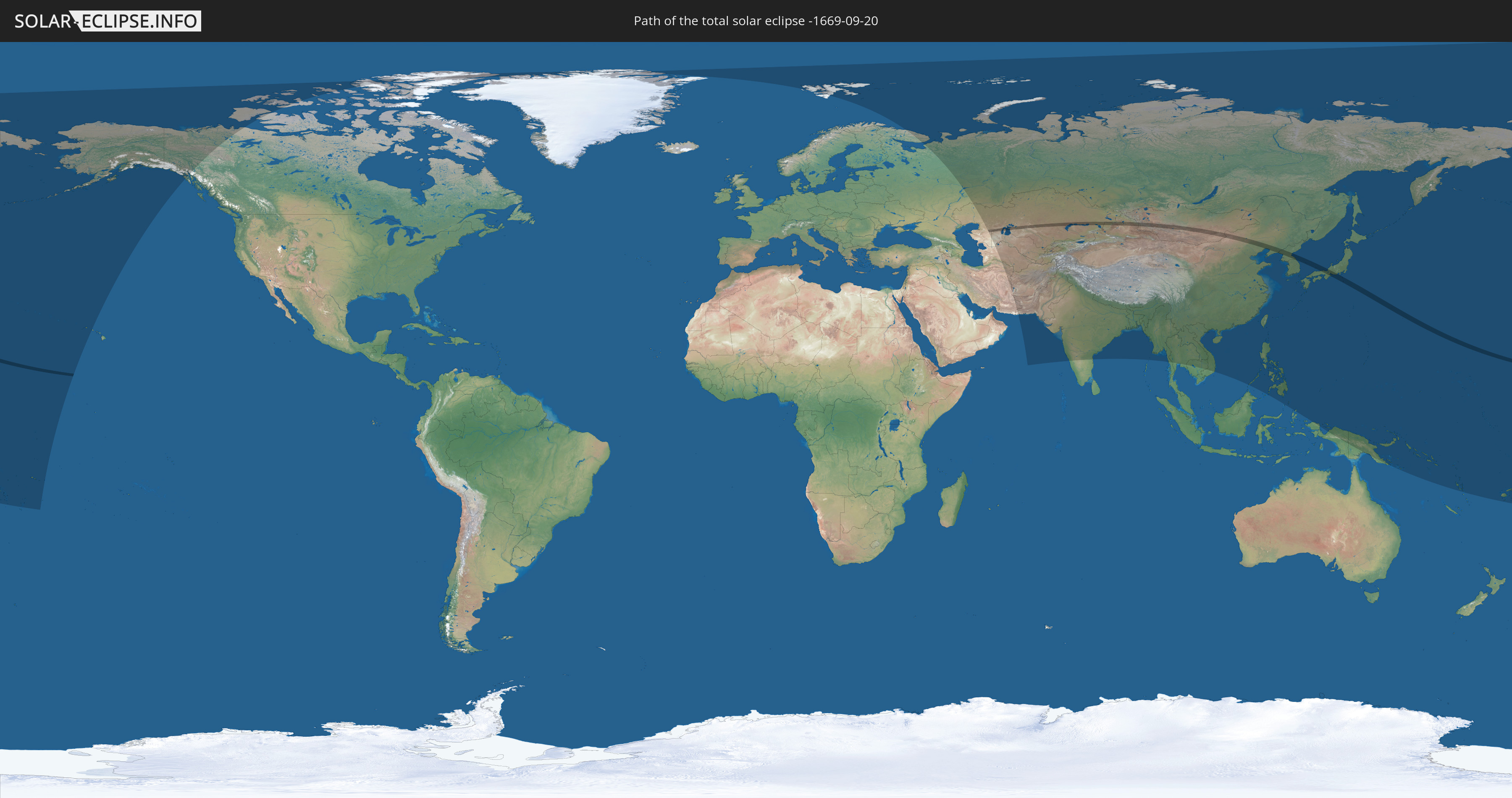
Total solar eclipse of 09/20/-1669
| Day of week: | Saturday |
| Maximum duration of eclipse: | 02m40s |
| Maximum width of eclipse path: | 119 km |
| Saros cycle: | 27 |
| Coverage: | 100% |
| Magnitude: | 1.0313 |
| Gamma: | 0.4697 |
Wo kann man die Sonnenfinsternis vom 09/20/-1669 sehen?
Die Sonnenfinsternis am 09/20/-1669 kann man in 50 Ländern als partielle Sonnenfinsternis beobachten.
Der Finsternispfad verläuft durch 8 Länder. Nur in diesen Ländern ist sie als total Sonnenfinsternis zu sehen.
In den folgenden Ländern ist die Sonnenfinsternis total zu sehen
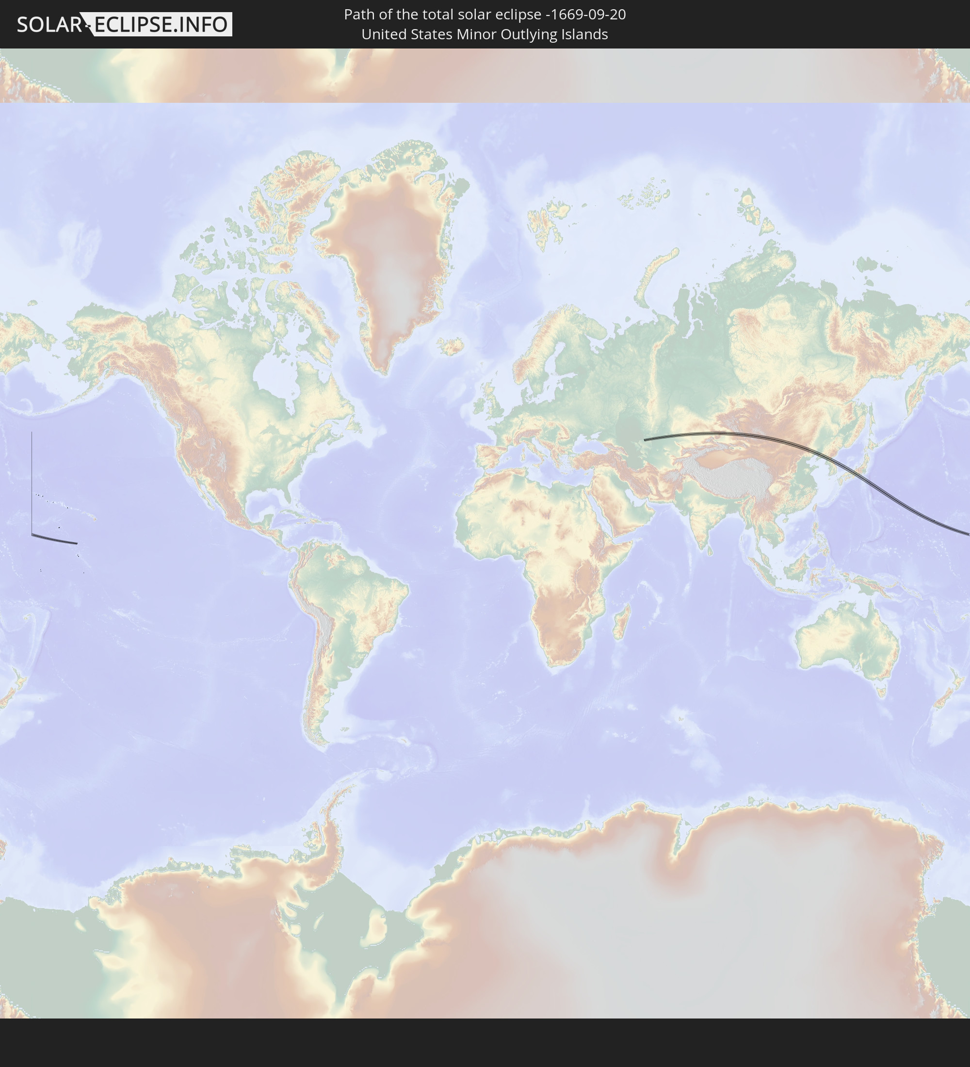 United States Minor Outlying Islands
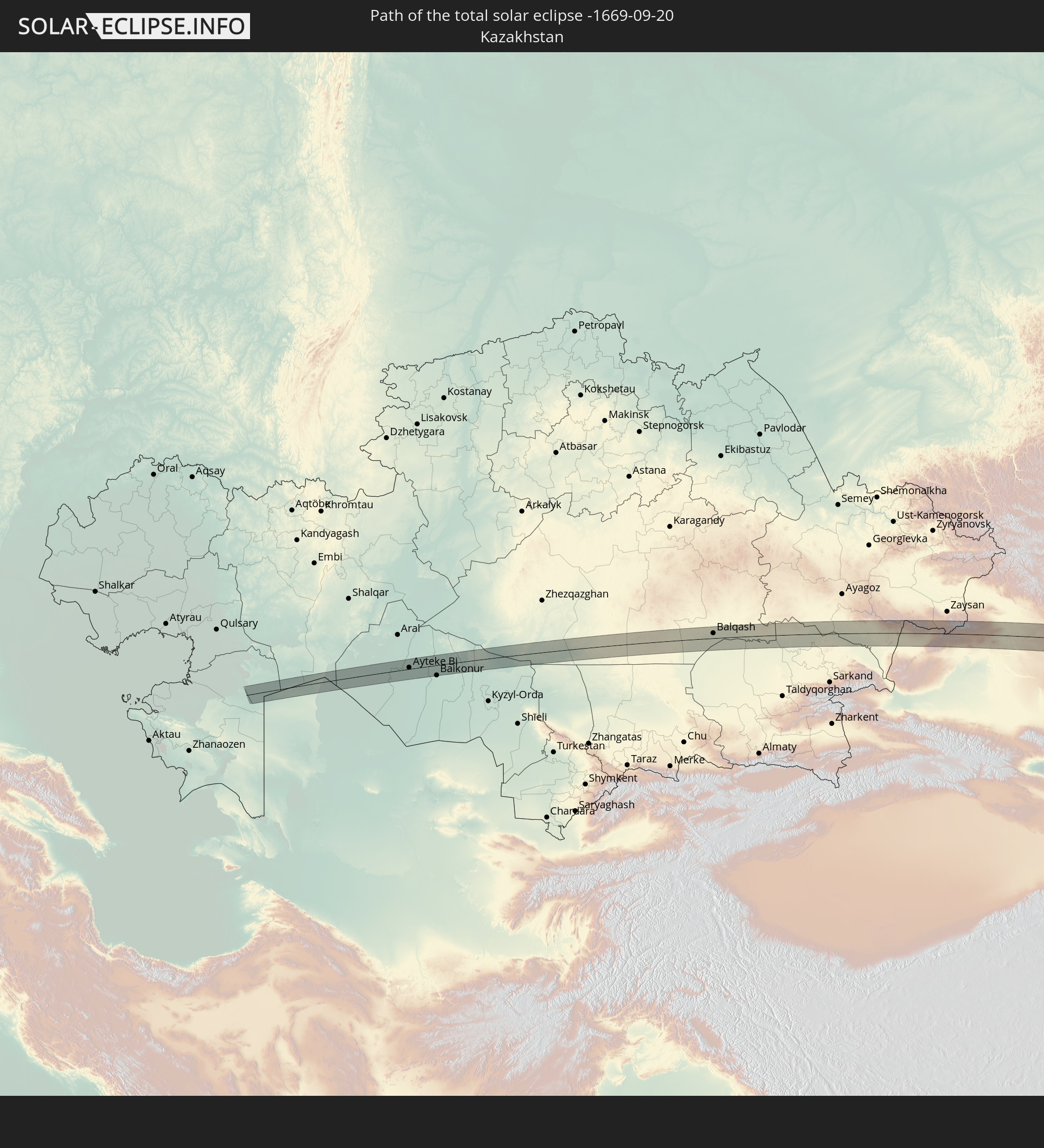 Kazakhstan
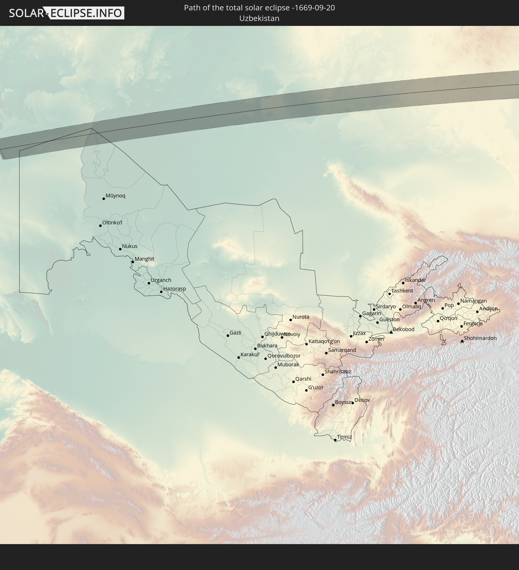 Uzbekistan
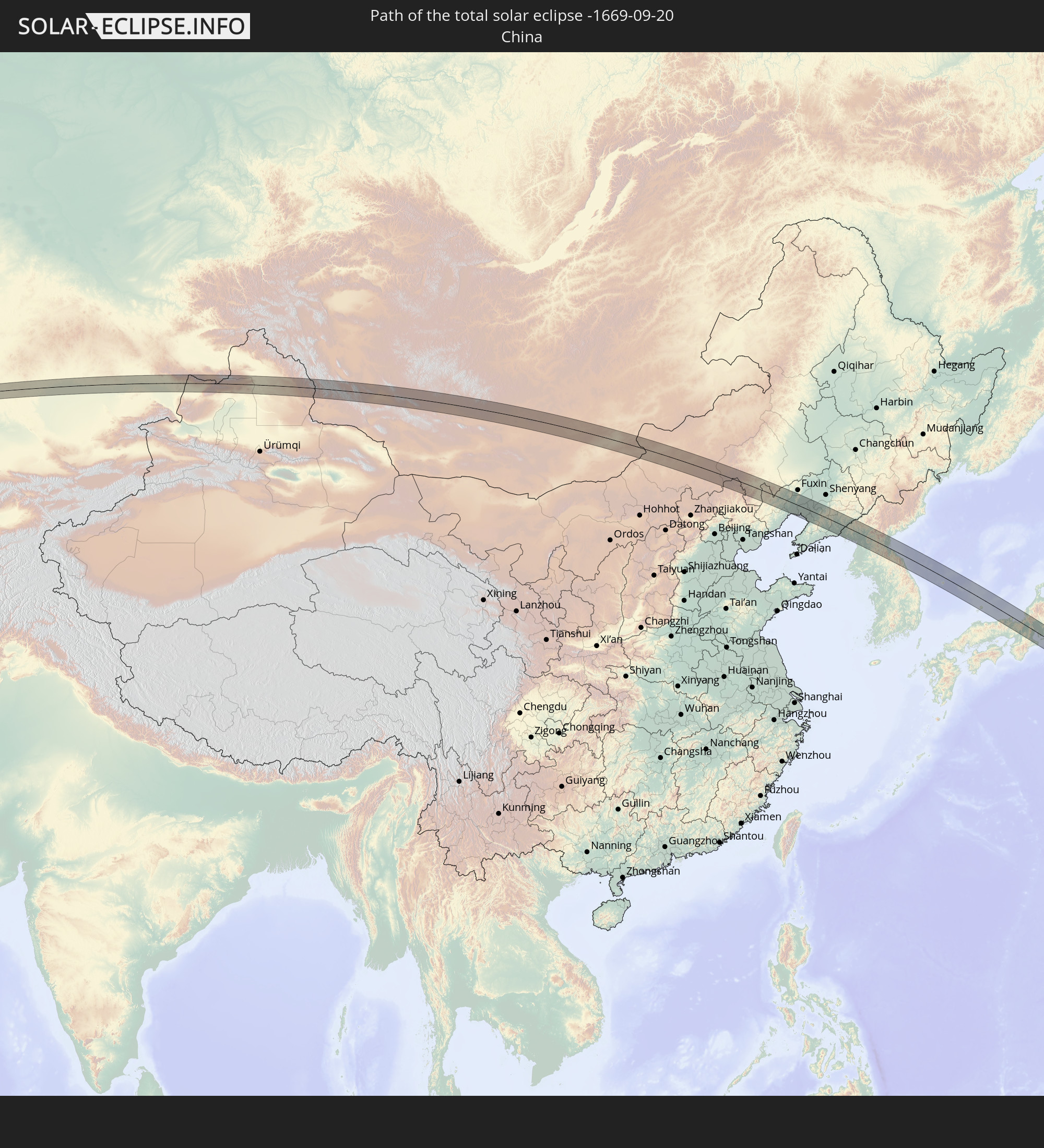 China
China
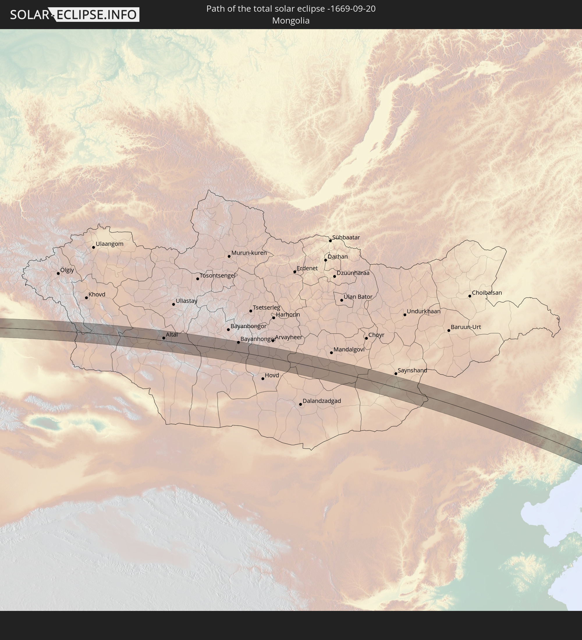 Mongolia
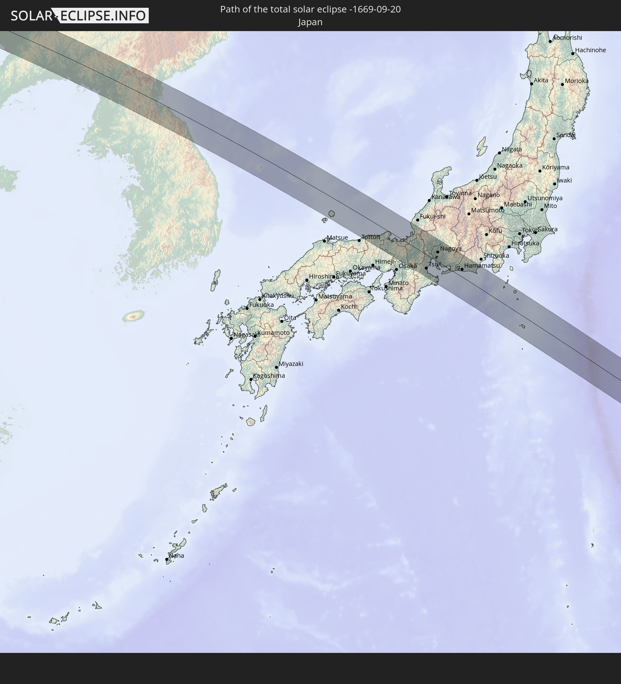 Japan
Japan
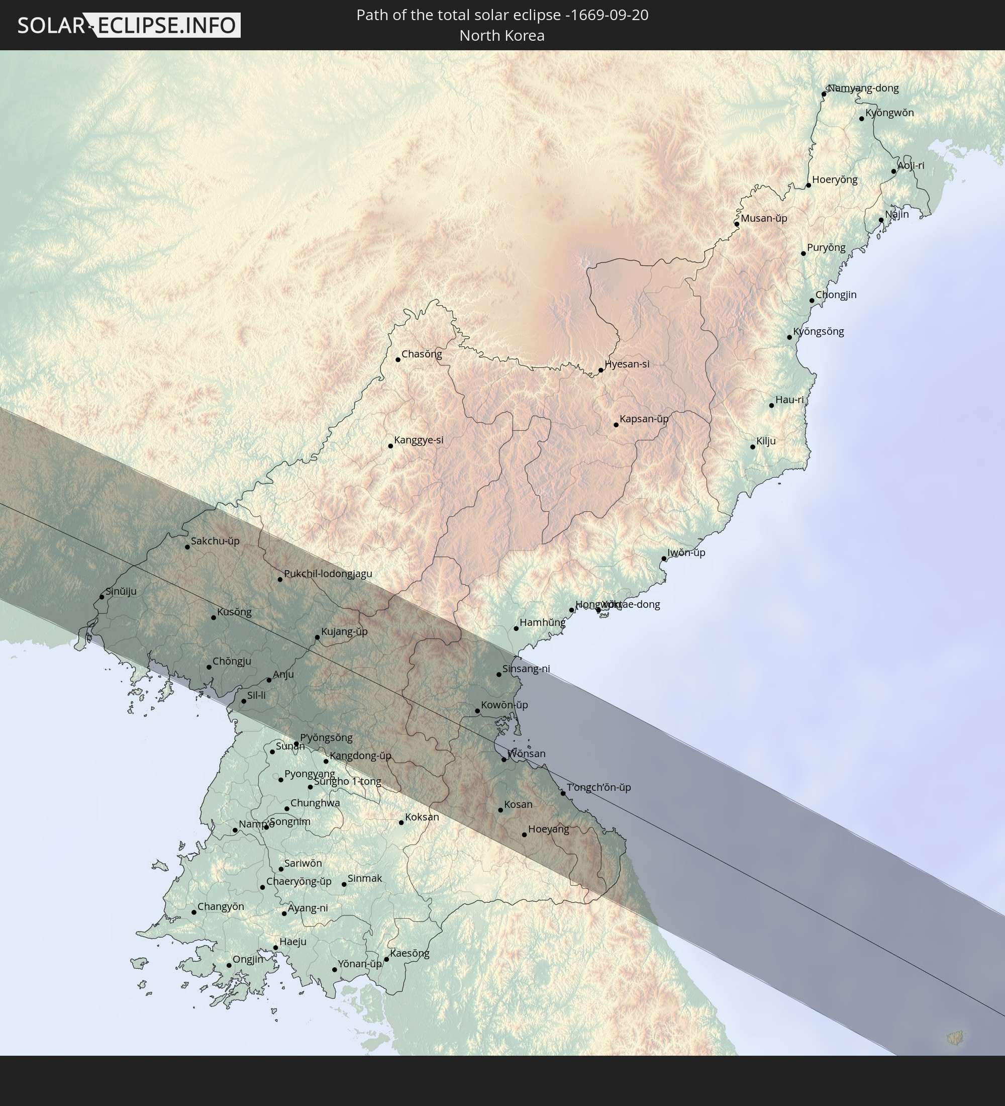 North Korea
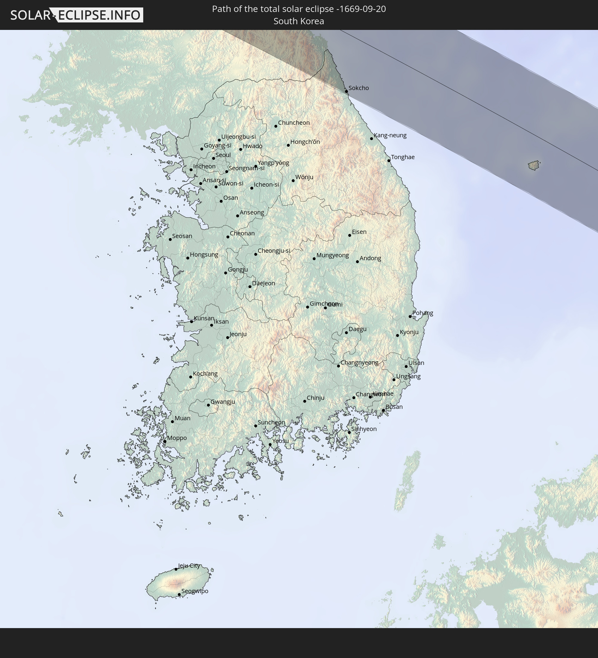 South Korea
In den folgenden Ländern ist die Sonnenfinsternis partiell zu sehen
 Fiji
Fiji
 Russia
 United States
 United States Minor Outlying Islands
 Wallis and Futuna
 Tonga
Tonga
 Kiribati
 Samoa
Samoa
 Tokelau
 American Samoa
 Canada
 Greenland
 Svalbard and Jan Mayen
 Iran
Iran
 Kazakhstan
 Turkmenistan
 Uzbekistan
 Afghanistan
 Pakistan
 Tajikistan
 India
India
 Kyrgyzstan
 China
China
 Nepal
Nepal
 Mongolia
 Bangladesh
 Bhutan
 Myanmar
 Indonesia
 Thailand
 Laos
Laos
 Vietnam
 Cambodia
 Macau
Macau
 Hong Kong
 Taiwan
 Philippines
 Japan
Japan
 North Korea
 South Korea
 Palau
Palau
 Federated States of Micronesia
 Papua New Guinea
 Guam
Guam
 Northern Mariana Islands
 Solomon Islands
 Marshall Islands
 Vanuatu
 Nauru
Nauru
 Tuvalu
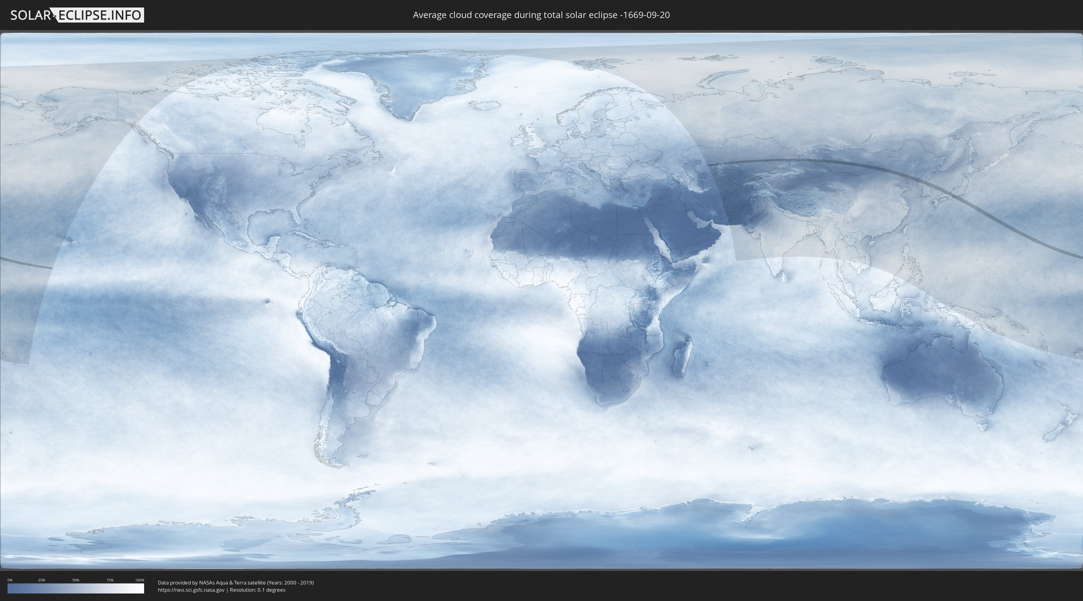
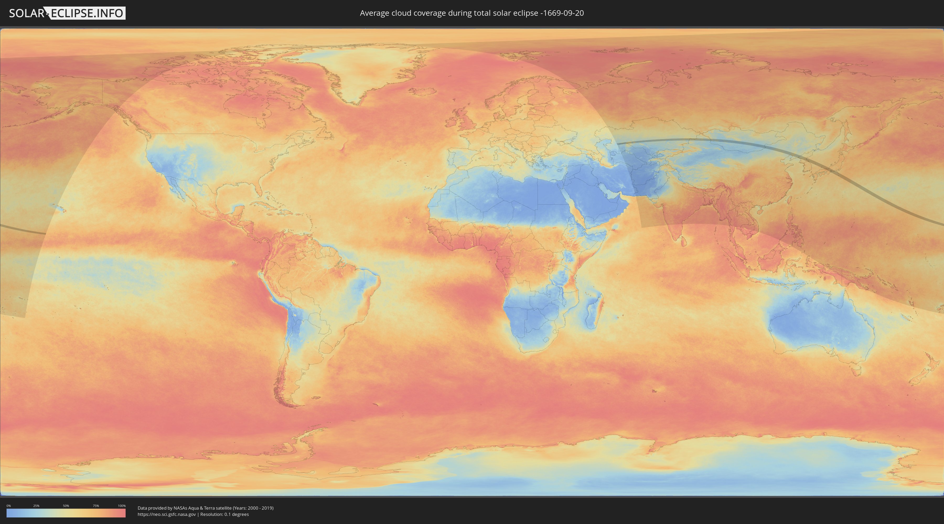
How will be the weather during the total solar eclipse on 09/20/-1669?
Where is the best place to see the total solar eclipse of 09/20/-1669?
The following maps show the average cloud coverage for the day of the total solar eclipse.
With the help of these maps, it is possible to find the place along the eclipse path, which has the best
chance of a cloudless sky.
Nevertheless, you should consider local circumstances and inform about the weather of your chosen
observation site.
The data is provided by NASAs satellites
AQUA and TERRA.
The cloud maps are averaged over a period of 19 years (2000 - 2019).
Detailed country maps
 United States Minor Outlying Islands
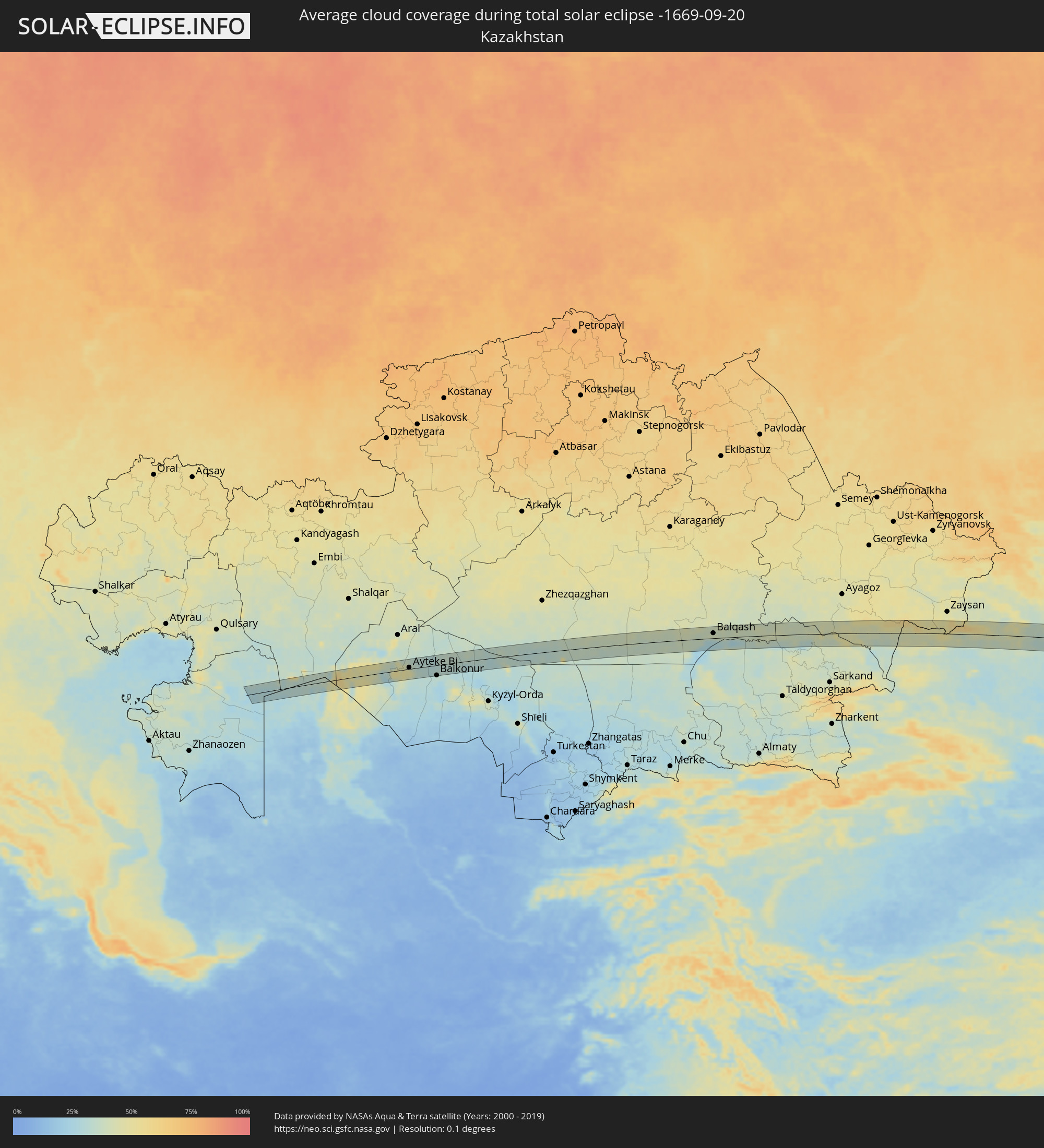 Kazakhstan
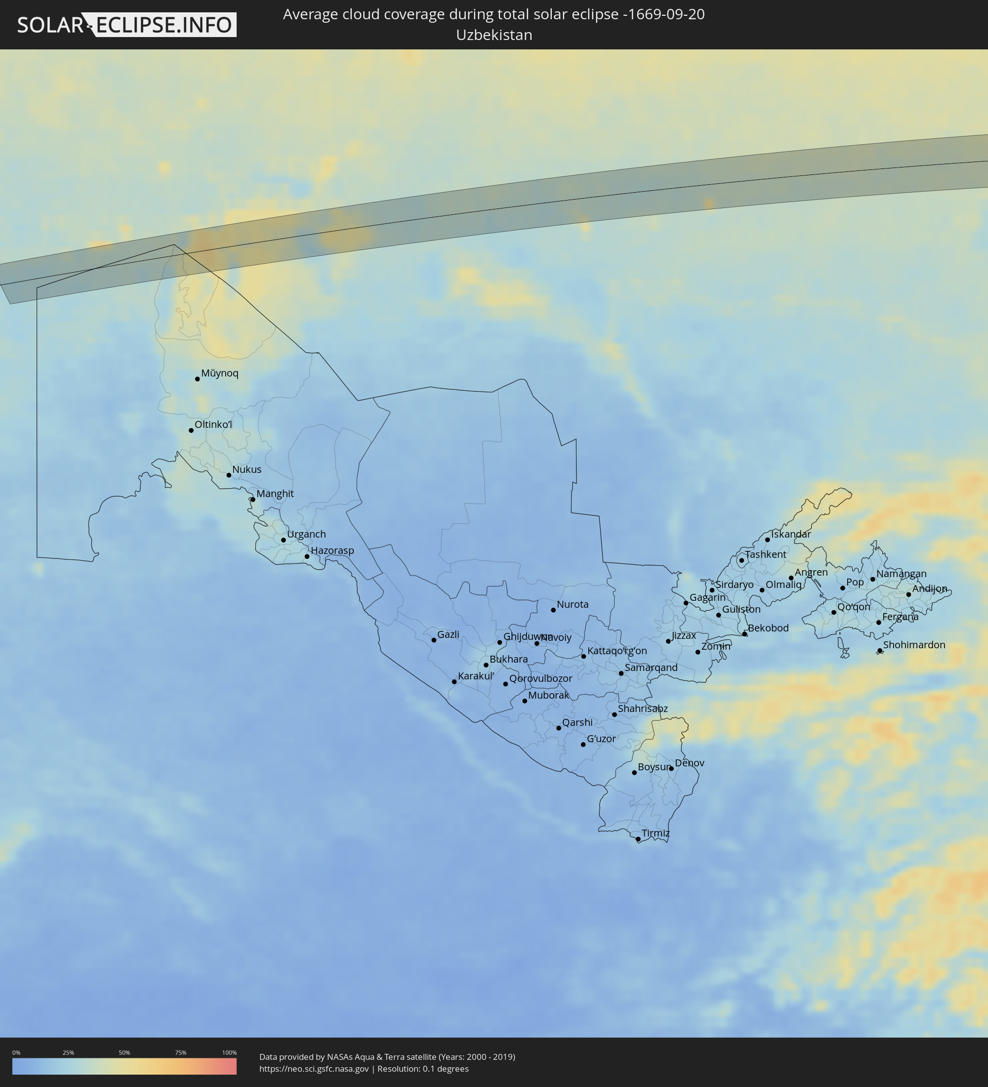 Uzbekistan
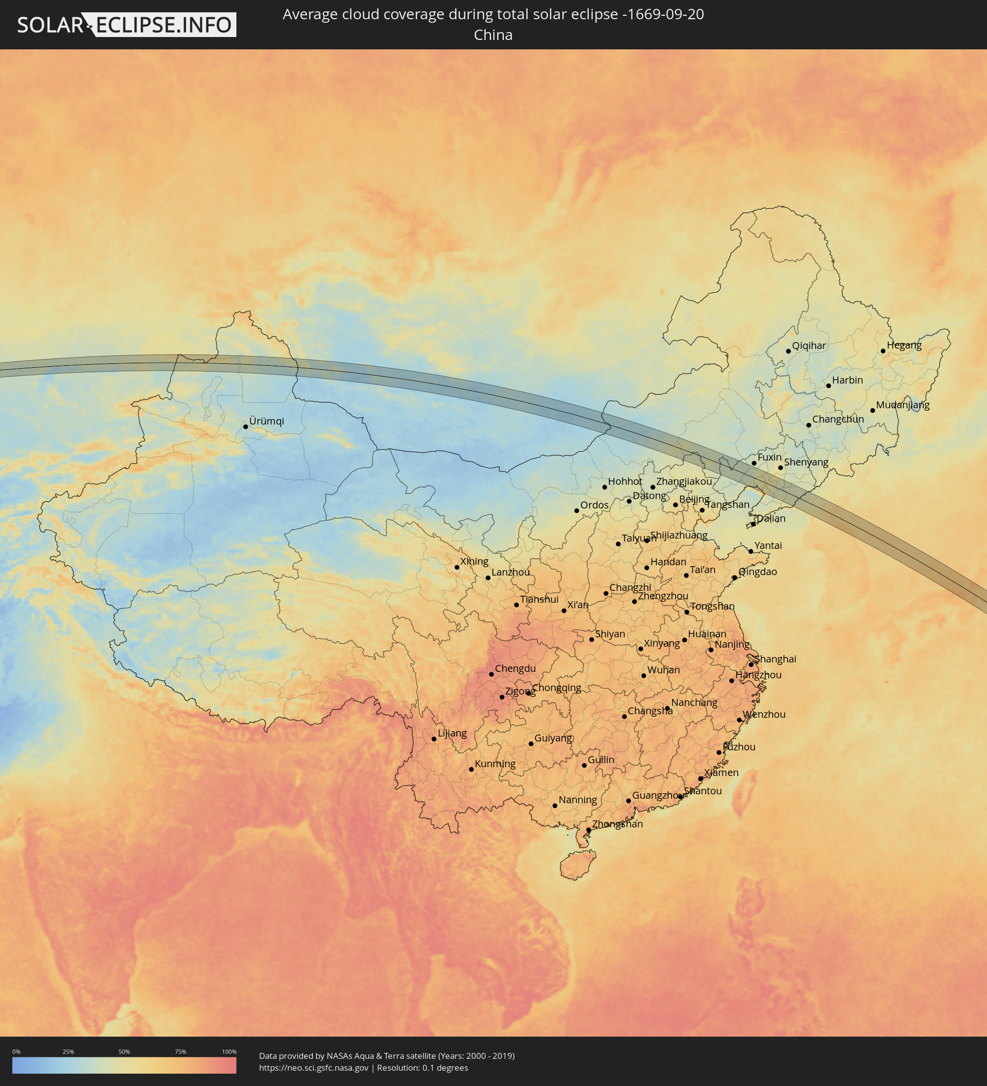 China
China
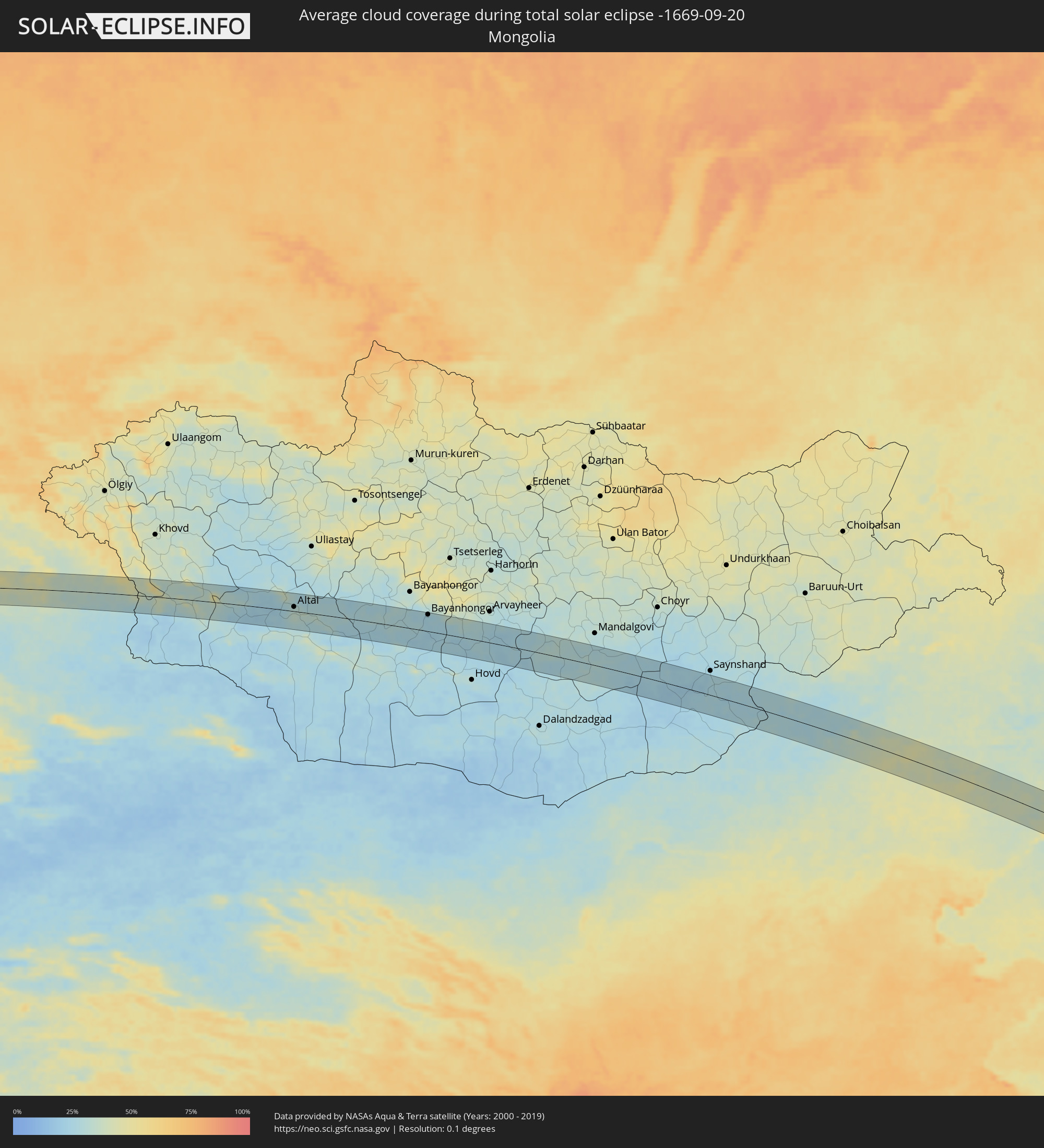 Mongolia
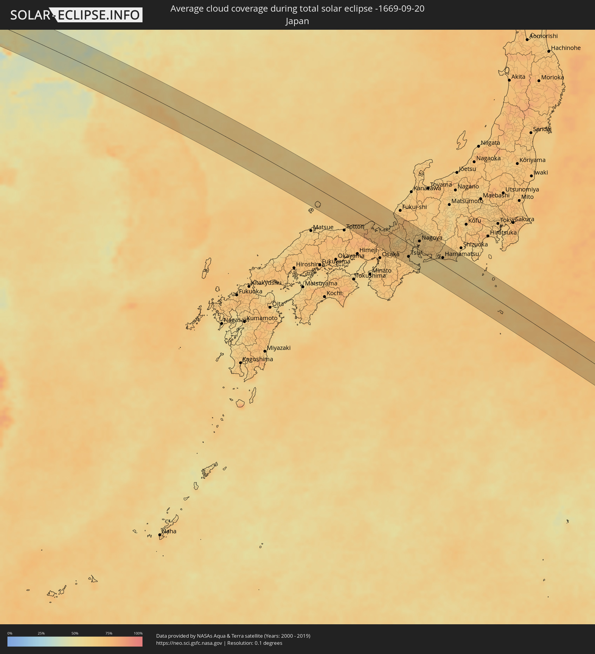 Japan
Japan
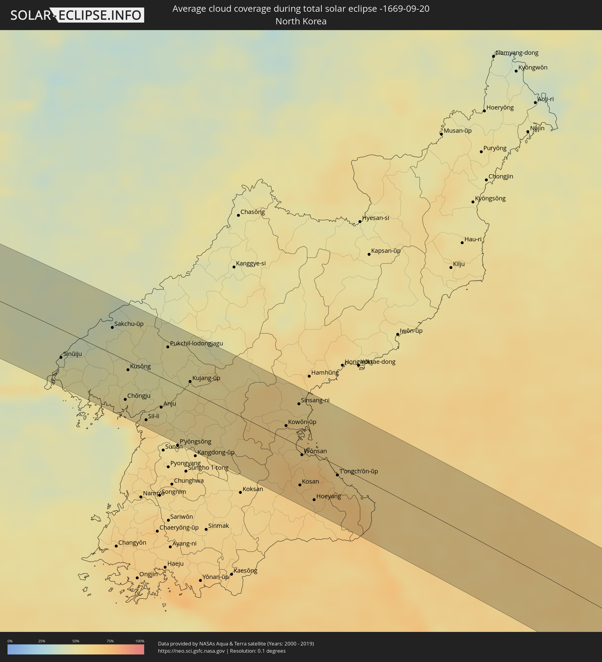 North Korea
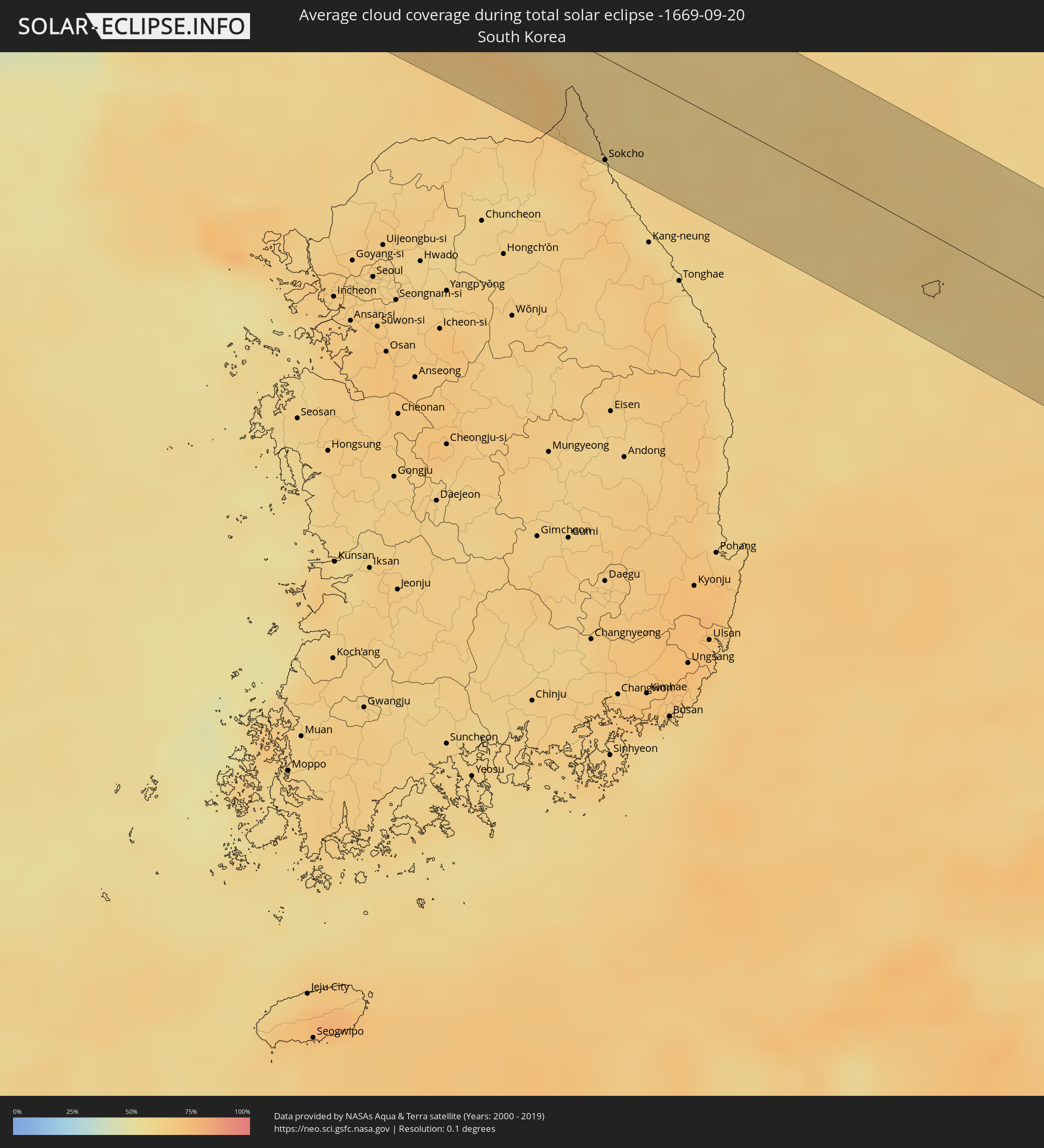 South Korea
Cities inside the path of the eclipse
The following table shows all locations with a population of more than 5,000 inside the eclipse path. Cities which have more than 100,000 inhabitants are marked bold. A click at the locations opens a detailed map.
| City | Type | Eclipse duration | Local time of max. eclipse | Distance to central line | Ø Cloud coverage |
|
Qazaly, Qyzylorda
|
total | - | 06:12:33 UTC+04:21 | 4 km | 47% |
|
Ayteke Bi, Qyzylorda
|
total | - | 06:12:37 UTC+04:21 | 4 km | 47% |
|
Tyuratam, Baikonur
|
total | - | 06:12:30 UTC+04:21 | 29 km | 33% |
|
Baikonur, Baikonur
|
total | - | 06:12:28 UTC+04:21 | 33 km | 32% |
|
Balqash, Qaraghandy
|
total | - | 06:16:03 UTC+04:21 | 16 km | 33% |
|
Urzhar, East Kazakhstan
|
total | - | 06:19:13 UTC+04:21 | 27 km | 44% |
|
Hoxtolgay, Xinjiang Uyghur Autonomous Region
|
total | - | 09:59:27 UTC+08:00 | 33 km | 32% |
|
Altai, Govĭ-Altay
|
total | - | 08:14:19 UTC+06:06 | 11 km | 31% |
|
Bayanhongor, Bayanhongor
|
total | - | 09:19:46 UTC+07:07 | 42 km | 25% |
|
Erenhot, Inner Mongolia
|
total | - | 10:26:02 UTC+08:00 | 29 km | 30% |
|
Mujiayingzi, Inner Mongolia
|
total | - | 10:37:02 UTC+08:00 | 7 km | 43% |
|
Chifeng, Inner Mongolia
|
total | - | 10:37:18 UTC+08:00 | 14 km | 42% |
|
Pingzhuang, Inner Mongolia
|
total | - | 10:37:55 UTC+08:00 | 0 km | 40% |
|
Chaoyang, Liaoning
|
total | - | 10:40:04 UTC+08:00 | 12 km | 41% |
|
Nanpiao, Liaoning
|
total | - | 10:40:45 UTC+08:00 | 51 km | 38% |
|
Beipiao, Liaoning
|
total | - | 10:40:33 UTC+08:00 | 21 km | 38% |
|
Jinzhou, Liaoning
|
total | - | 10:41:27 UTC+08:00 | 37 km | 42% |
|
Linghai, Liaoning
|
total | - | 10:41:50 UTC+08:00 | 24 km | 44% |
|
Panshan, Liaoning
|
total | - | 10:43:02 UTC+08:00 | 1 km | 50% |
|
Heishan, Liaoning
|
total | - | 10:42:56 UTC+08:00 | 54 km | 47% |
|
Yingkou, Liaoning
|
total | - | 10:43:35 UTC+08:00 | 46 km | 61% |
|
Dashiqiao, Liaoning
|
total | - | 10:44:06 UTC+08:00 | 40 km | 48% |
|
Haicheng, Liaoning
|
total | - | 10:44:26 UTC+08:00 | 10 km | 49% |
|
Nantai, Liaoning
|
total | - | 10:44:30 UTC+08:00 | 0 km | 47% |
|
Jiupu, Liaoning
|
total | - | 10:44:42 UTC+08:00 | 19 km | 46% |
|
Anshan, Liaoning
|
total | - | 10:44:45 UTC+08:00 | 26 km | 46% |
|
Liaoyang, Liaoning
|
total | - | 10:45:00 UTC+08:00 | 48 km | 47% |
|
Xiuyan, Liaoning
|
total | - | 10:45:41 UTC+08:00 | 48 km | 46% |
|
Gongchangling, Liaoning
|
total | - | 10:45:34 UTC+08:00 | 42 km | 42% |
|
Fengcheng, Liaoning
|
total | - | 10:47:03 UTC+08:00 | 3 km | 42% |
|
Langtou, Liaoning
|
total | - | 10:47:46 UTC+08:00 | 37 km | 48% |
|
Dandong, Liaoning
|
total | - | 10:47:50 UTC+08:00 | 25 km | 44% |
|
Sinŭiju, P'yŏngan-bukto
|
total | - | 11:10:52 UTC+08:23 | 27 km | 44% |
|
Ŭiju, P'yŏngan-bukto
|
total | - | 11:11:03 UTC+08:23 | 13 km | 42% |
|
Yŏmju-ŭp, P'yŏngan-bukto
|
total | - | 11:11:21 UTC+08:23 | 41 km | 49% |
|
Kuandian, Liaoning
|
total | - | 10:48:12 UTC+08:00 | 50 km | 44% |
|
Sakchu-ŭp, P'yŏngan-bukto
|
total | - | 11:11:53 UTC+08:23 | 25 km | 44% |
|
Kwaksan, P'yŏngan-bukto
|
total | - | 11:12:23 UTC+08:23 | 44 km | 55% |
|
Chŏngju, P'yŏngan-bukto
|
total | - | 11:12:37 UTC+08:23 | 39 km | 54% |
|
Panghyŏn-dong, P'yŏngan-bukto
|
total | - | 11:12:34 UTC+08:23 | 18 km | 50% |
|
Kusŏng, P'yŏngan-bukto
|
total | - | 11:12:30 UTC+08:23 | 8 km | 48% |
|
Sil-li, P'yŏngan-namdo
|
total | - | 11:13:15 UTC+08:23 | 49 km | 60% |
|
Sinanju, P'yŏngan-namdo
|
total | - | 11:13:26 UTC+08:23 | 33 km | 54% |
|
Anju, P'yŏngan-namdo
|
total | - | 11:13:32 UTC+08:23 | 29 km | 53% |
|
Pukchil-lodongjagu, P'yŏngan-bukto
|
total | - | 11:13:18 UTC+08:23 | 32 km | 50% |
|
Yŏngbyŏn, P'yŏngan-bukto
|
total | - | 11:13:40 UTC+08:23 | 4 km | 51% |
|
Kujang-ŭp, P'yŏngan-bukto
|
total | - | 11:14:03 UTC+08:23 | 9 km | 51% |
|
Sangsŏng-ni, P'yŏngan-namdo
|
total | - | 11:16:10 UTC+08:23 | 27 km | 63% |
|
Kowŏn-ŭp, Hamgyŏng-namdo
|
total | - | 11:16:39 UTC+08:23 | 13 km | 63% |
|
Sinsang-ni, Hamgyŏng-namdo
|
total | - | 11:16:48 UTC+08:23 | 41 km | 57% |
|
Kosan, Kangwŏn-do
|
total | - | 11:17:25 UTC+08:23 | 38 km | 67% |
|
Wŏnsan, Kangwŏn-do
|
total | - | 11:17:14 UTC+08:23 | 7 km | 62% |
|
Anbyŏn-ŭp, Kangwŏn-do
|
total | - | 11:17:29 UTC+08:23 | 15 km | 67% |
|
Hoeyang, Kangwŏn-do
|
total | - | 11:17:53 UTC+08:23 | 45 km | 65% |
|
T’ongch’ŏn-ŭp, Kangwŏn-do
|
total | - | 11:18:15 UTC+08:23 | 9 km | 62% |
|
Kosong, Gangwon-do
|
total | - | 11:24:42 UTC+08:27 | 43 km | 60% |
|
Sokcho, Gangwon-do
|
total | - | 11:25:05 UTC+08:27 | 55 km | 61% |
|
Toyooka, Hyōgo
|
total | - | 12:12:24 UTC+09:00 | 40 km | 75% |
|
Fukuchiyama, Kyoto
|
total | - | 12:13:18 UTC+09:00 | 49 km | 77% |
|
Maizuru, Kyoto
|
total | - | 12:13:33 UTC+09:00 | 25 km | 71% |
|
Kameoka, Kyoto
|
total | - | 12:14:37 UTC+09:00 | 56 km | 72% |
|
Kyoto, Kyoto
|
total | - | 12:14:56 UTC+09:00 | 46 km | 70% |
|
Uji, Kyoto
|
total | - | 12:15:12 UTC+09:00 | 56 km | 70% |
|
Kusatsu, Shiga Prefecture
|
total | - | 12:15:22 UTC+09:00 | 36 km | 70% |
|
Tsuruga, Fukui
|
total | - | 12:14:46 UTC+09:00 | 28 km | 70% |
|
Ōmihachiman, Shiga Prefecture
|
total | - | 12:15:30 UTC+09:00 | 19 km | 70% |
|
Ueno-ebisumachi, Mie
|
total | - | 12:16:02 UTC+09:00 | 52 km | 69% |
|
Takefu, Fukui
|
total | - | 12:14:40 UTC+09:00 | 58 km | 73% |
|
Youkaichi, Shiga Prefecture
|
total | - | 12:15:43 UTC+09:00 | 15 km | 69% |
|
Hikone, Shiga Prefecture
|
total | - | 12:15:39 UTC+09:00 | 0 km | 68% |
|
Tsu, Mie
|
total | - | 12:16:51 UTC+09:00 | 36 km | 64% |
|
Ōgaki, Gifu
|
total | - | 12:16:16 UTC+09:00 | 27 km | 65% |
|
Yokkaichi, Mie
|
total | - | 12:16:45 UTC+09:00 | 9 km | 64% |
|
Ise, Mie
|
total | - | 12:17:33 UTC+09:00 | 51 km | 66% |
|
Tsushima, Aichi
|
total | - | 12:16:42 UTC+09:00 | 14 km | 63% |
|
Gifu-shi, Gifu
|
total | - | 12:16:27 UTC+09:00 | 41 km | 66% |
|
Nagoya, Aichi
|
total | - | 12:17:03 UTC+09:00 | 25 km | 65% |
|
Taketoyo, Aichi
|
total | - | 12:17:30 UTC+09:00 | 6 km | 61% |
|
Handa, Aichi
|
total | - | 12:17:30 UTC+09:00 | 2 km | 61% |
|
Inuyama, Gifu
|
total | - | 12:16:53 UTC+09:00 | 45 km | 66% |
|
Anjō, Aichi
|
total | - | 12:17:42 UTC+09:00 | 12 km | 67% |
|
Seto, Aichi
|
total | - | 12:17:23 UTC+09:00 | 39 km | 67% |
|
Toyota, Aichi
|
total | - | 12:17:40 UTC+09:00 | 27 km | 67% |
|
Toki, Gifu
|
total | - | 12:17:24 UTC+09:00 | 54 km | 65% |
|
Gamagōri, Aichi
|
total | - | 12:18:10 UTC+09:00 | 8 km | 62% |
|
Mizunami, Gifu
|
total | - | 12:17:30 UTC+09:00 | 59 km | 66% |
|
Toyohashi, Aichi
|
total | - | 12:18:33 UTC+09:00 | 9 km | 64% |
|
Kosai-shi, Shizuoka
|
total | - | 12:18:55 UTC+09:00 | 12 km | 58% |
|
Hamamatsu, Shizuoka
|
total | - | 12:19:21 UTC+09:00 | 20 km | 59% |
|
Kakegawa, Shizuoka
|
total | - | 12:19:50 UTC+09:00 | 40 km | 67% |
|
Shimada, Shizuoka
|
total | - | 12:20:06 UTC+09:00 | 53 km | 63% |