Total solar eclipse of 01/12/-1703
| Day of week: | Sunday |
| Maximum duration of eclipse: | 03m01s |
| Maximum width of eclipse path: | 158 km |
| Saros cycle: | 4 |
| Coverage: | 100% |
| Magnitude: | 1.0318 |
| Gamma: | 0.7358 |
Wo kann man die Sonnenfinsternis vom 01/12/-1703 sehen?
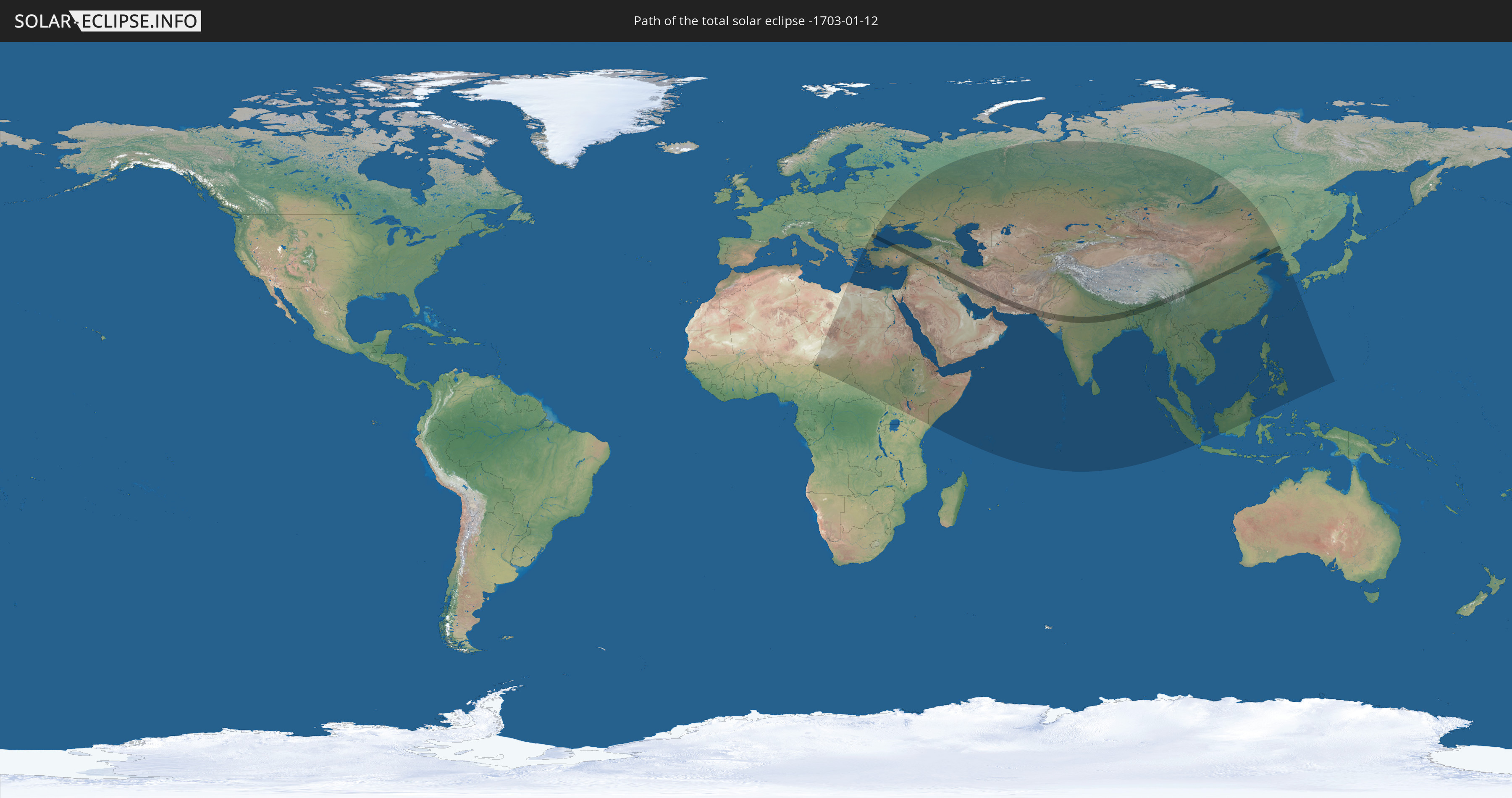
Die Sonnenfinsternis am 01/12/-1703 kann man in 73 Ländern als partielle Sonnenfinsternis beobachten.
Der Finsternispfad verläuft durch 12 Länder. Nur in diesen Ländern ist sie als total Sonnenfinsternis zu sehen.
In den folgenden Ländern ist die Sonnenfinsternis total zu sehen
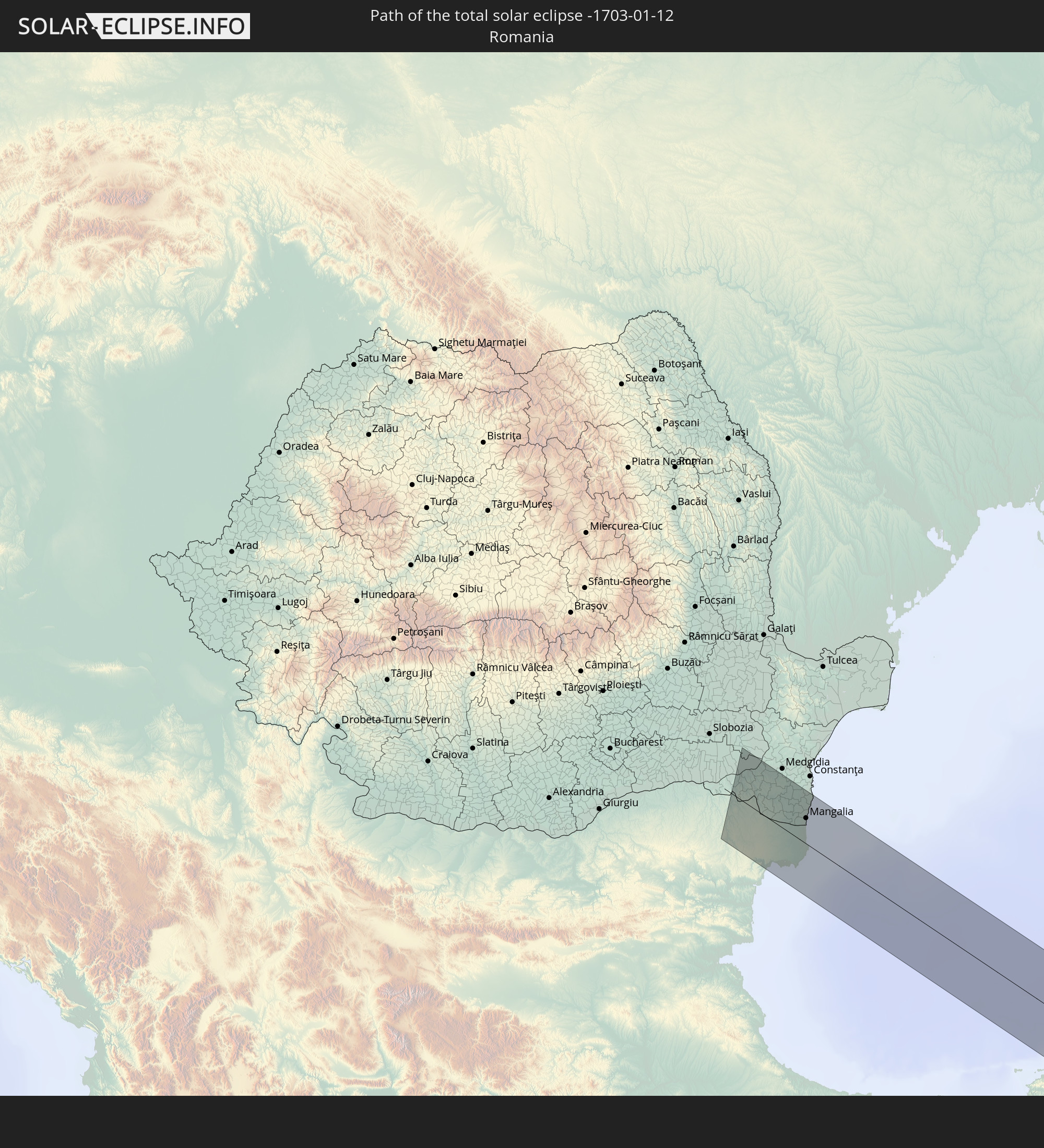 Romania
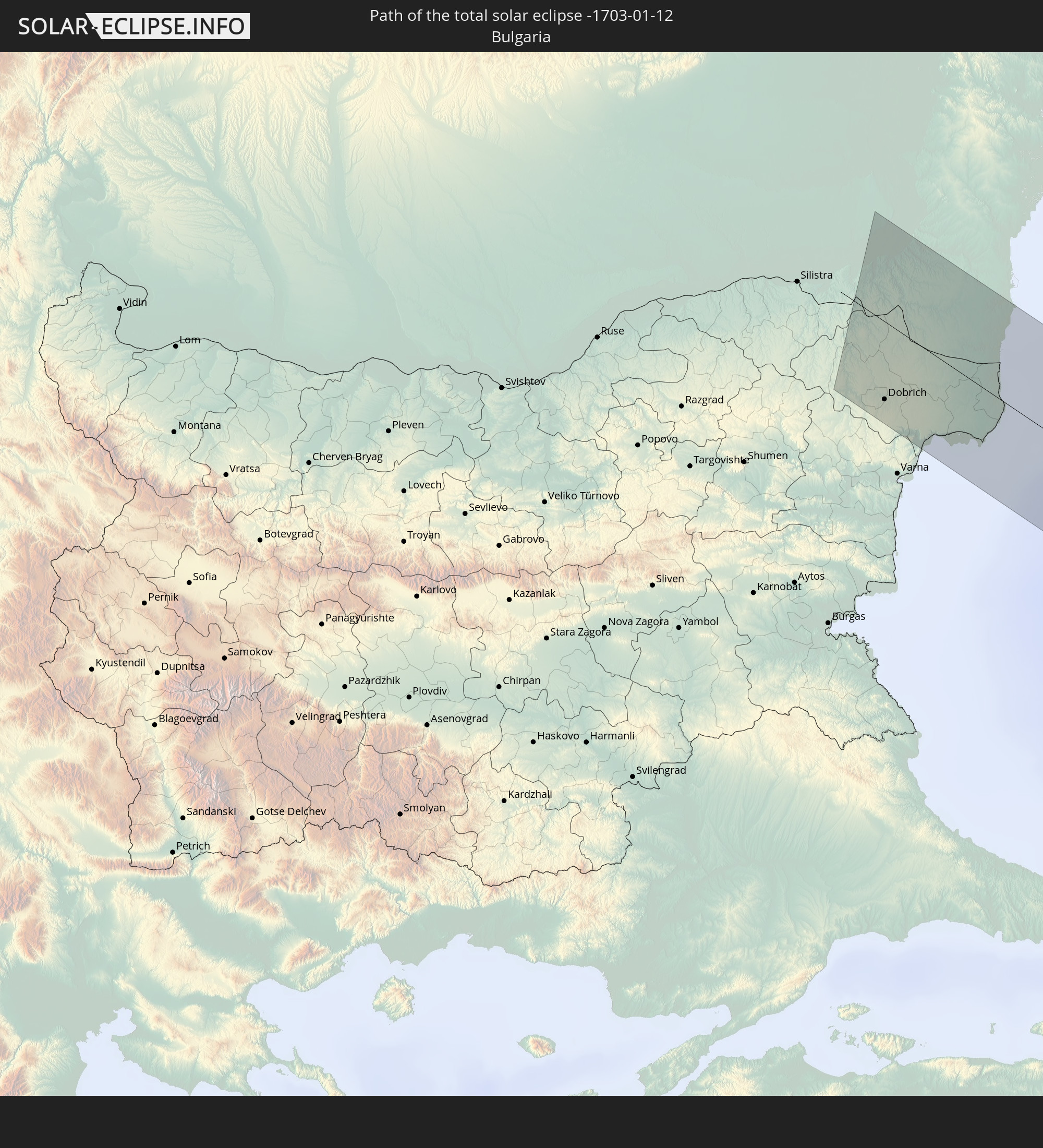 Bulgaria
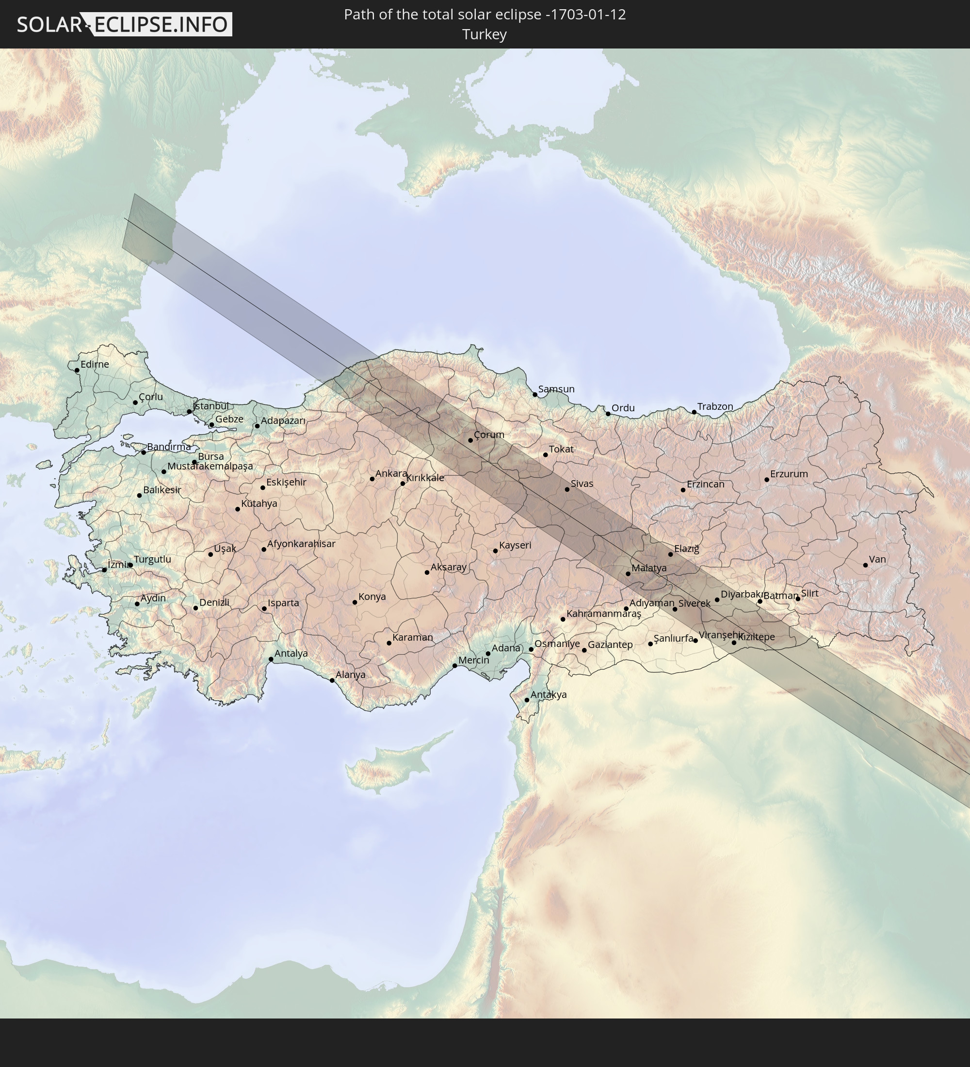 Turkey
 Syria
Syria
 Iraq
Iraq
 Iran
Iran
 Pakistan
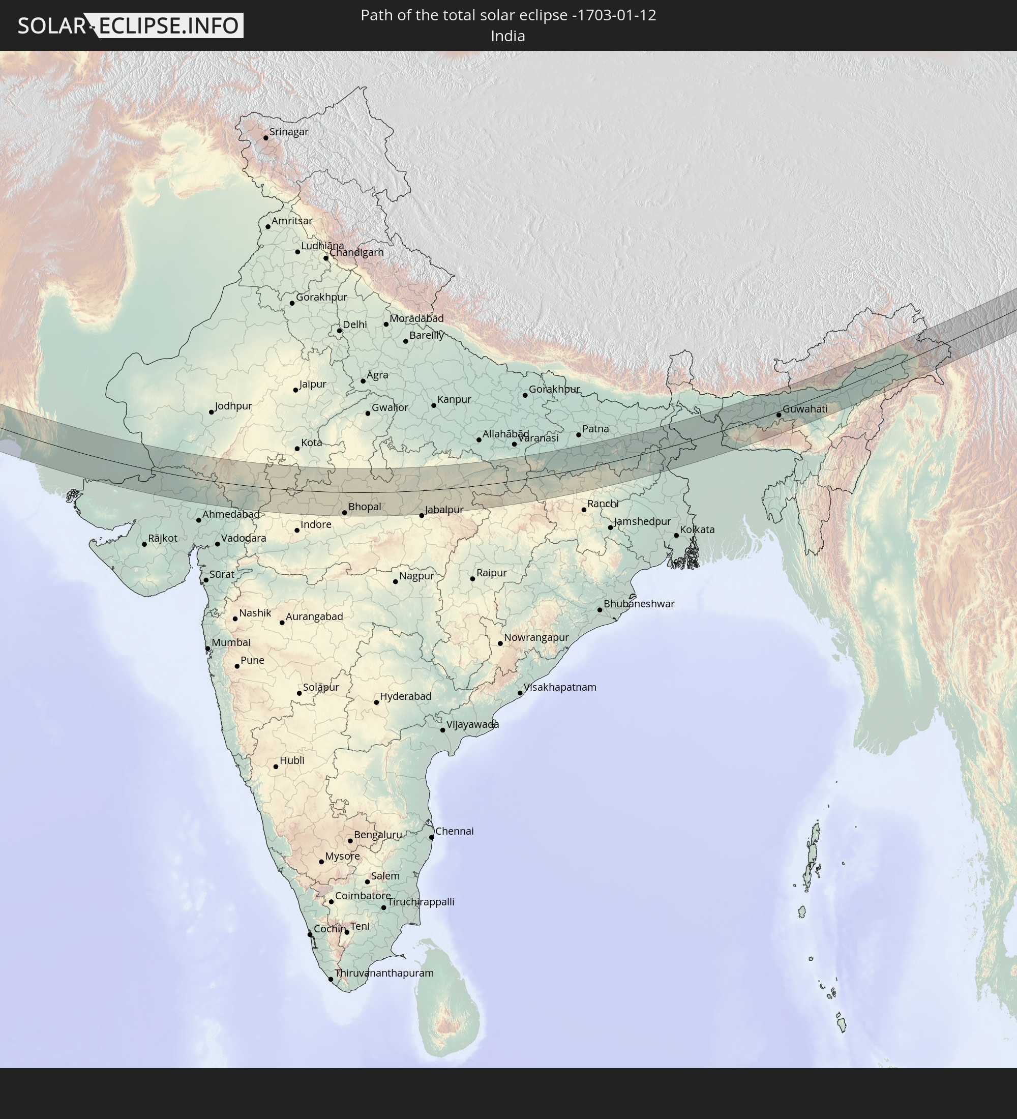 India
India
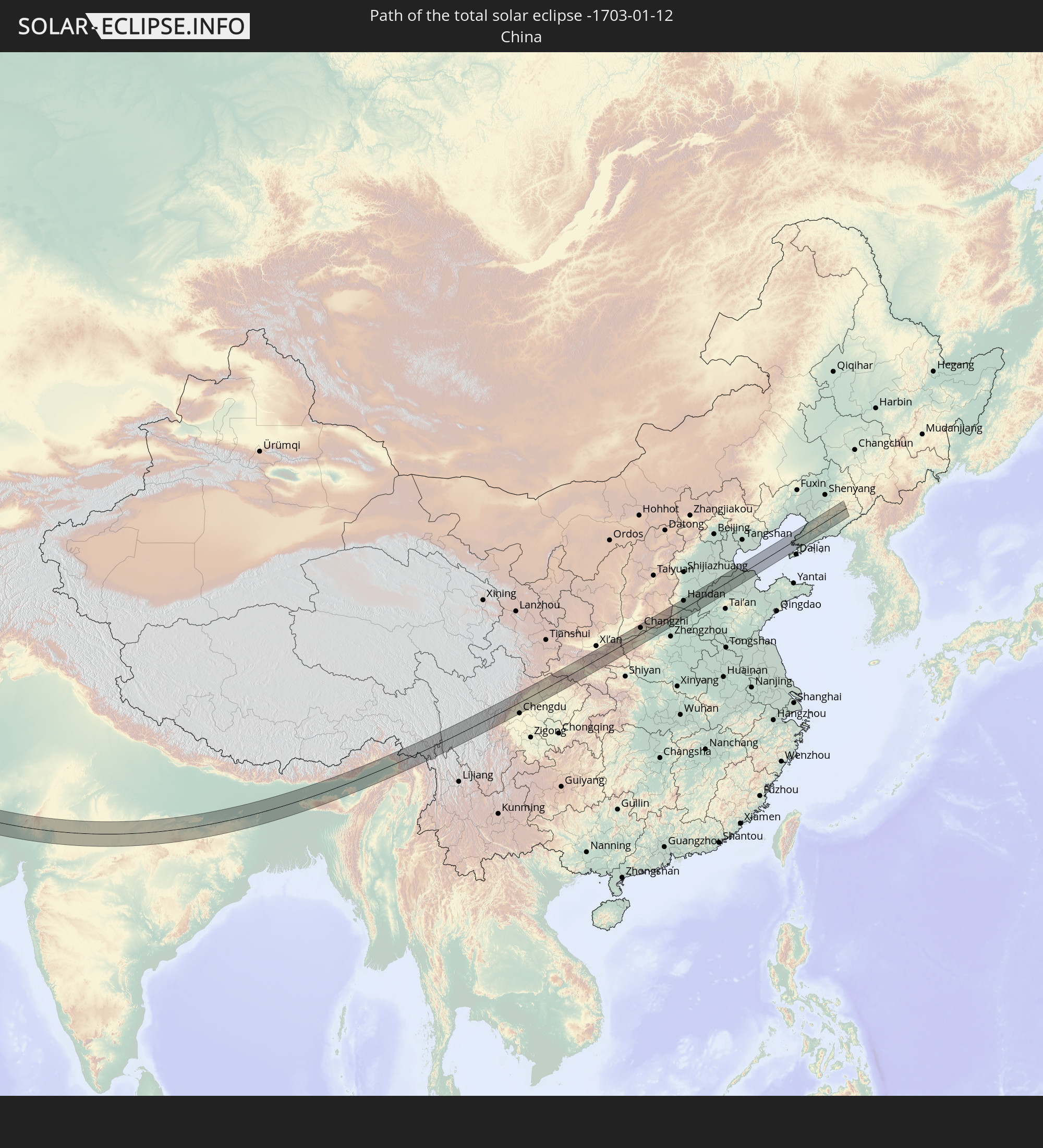 China
China
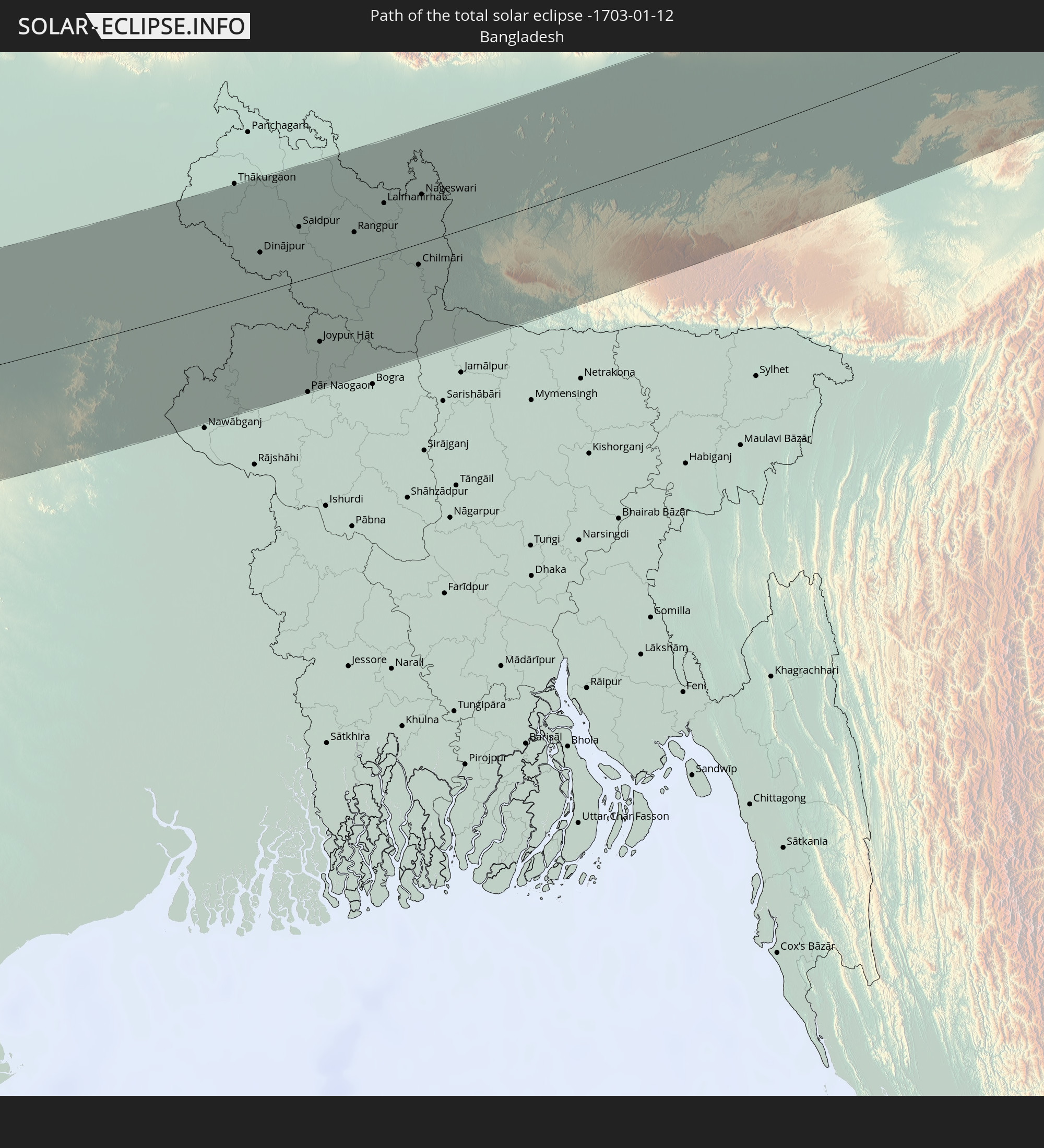 Bangladesh
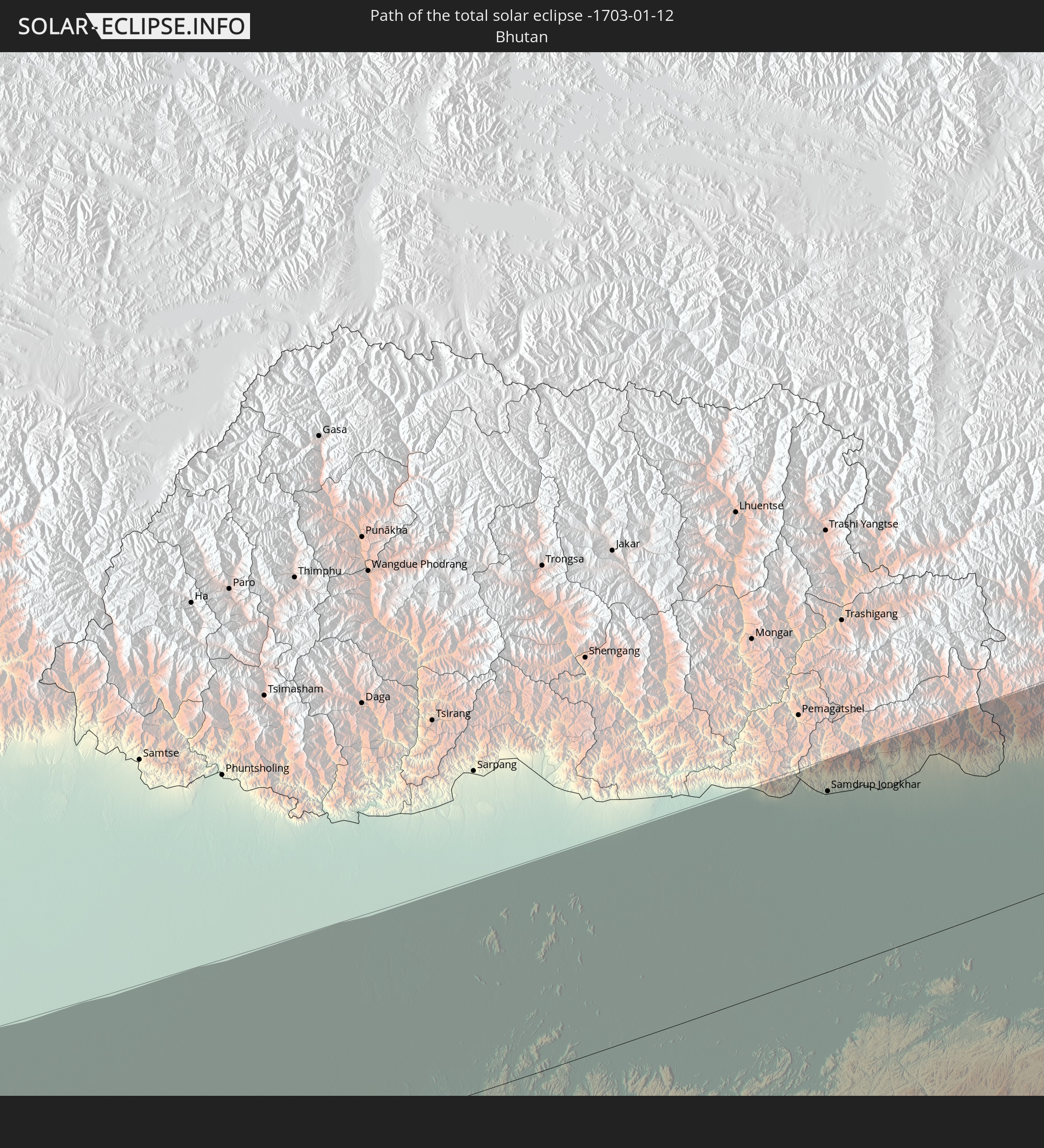 Bhutan
 Myanmar
In den folgenden Ländern ist die Sonnenfinsternis partiell zu sehen
 Russia
 Niger
Niger
 Nigeria
 Cameroon
 Libya
Libya
 Chad
Chad
 Central African Republic
 Greece
 Romania
 Sudan
Sudan
 Ukraine
 Bulgaria
 Egypt
Egypt
 Turkey
 Moldova
 Uganda
 Cyprus
 Ethiopia
 Kenya
Kenya
 State of Palestine
 Israel
 Saudi Arabia
 Jordan
 Lebanon
 Syria
Syria
 Eritrea
 Iraq
Iraq
 Georgia
 Somalia
 Djibouti
 Yemen
Yemen
 Armenia
 Iran
Iran
 Azerbaijan
 Seychelles
 Kazakhstan
 Kuwait
 Bahrain
 Qatar
Qatar
 United Arab Emirates
 Oman
Oman
 Turkmenistan
 Uzbekistan
 Afghanistan
 Pakistan
 Tajikistan
 India
India
 Kyrgyzstan
 British Indian Ocean Territory
 Maldives
 China
China
 Sri Lanka
 Nepal
Nepal
 Mongolia
 Bangladesh
 Bhutan
 Myanmar
 Indonesia
 Thailand
 Malaysia
 Laos
Laos
 Vietnam
 Cambodia
 Singapore
 Macau
Macau
 Hong Kong
 Brunei
 Taiwan
 Philippines
 Japan
Japan
 North Korea
 South Korea
 Palau
Palau
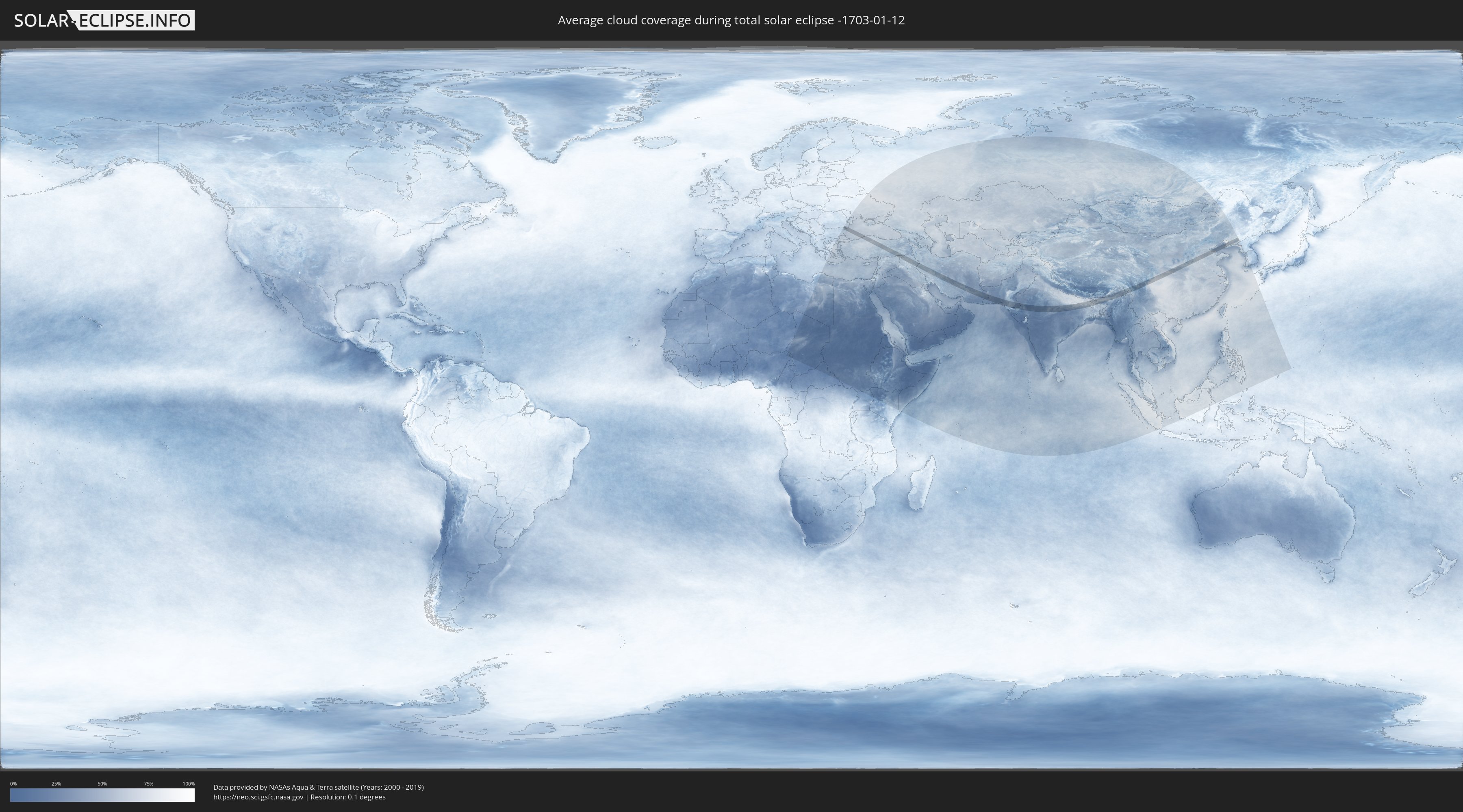
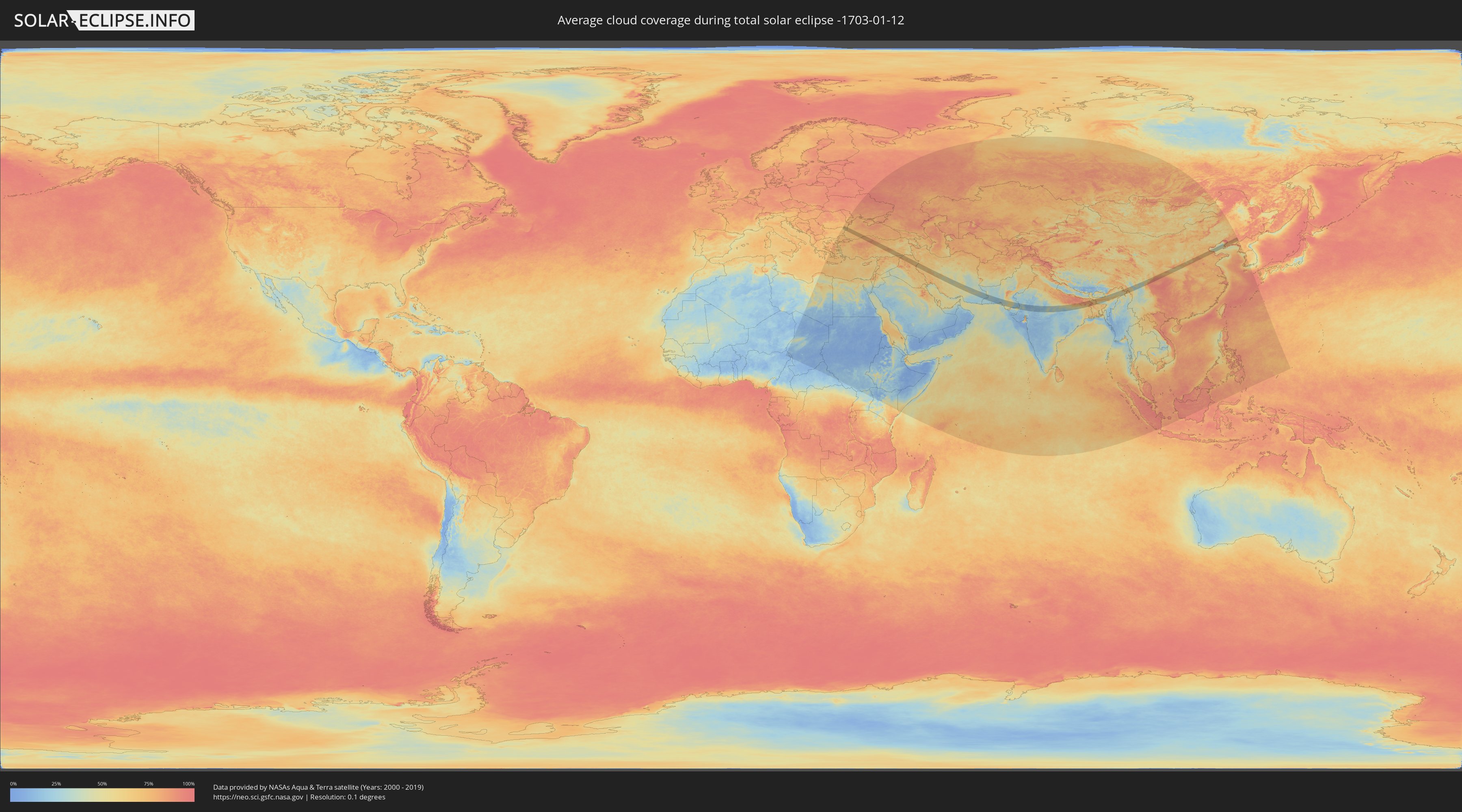
How will be the weather during the total solar eclipse on 01/12/-1703?
Where is the best place to see the total solar eclipse of 01/12/-1703?
The following maps show the average cloud coverage for the day of the total solar eclipse.
With the help of these maps, it is possible to find the place along the eclipse path, which has the best
chance of a cloudless sky.
Nevertheless, you should consider local circumstances and inform about the weather of your chosen
observation site.
The data is provided by NASAs satellites
AQUA and TERRA.
The cloud maps are averaged over a period of 19 years (2000 - 2019).
Detailed country maps
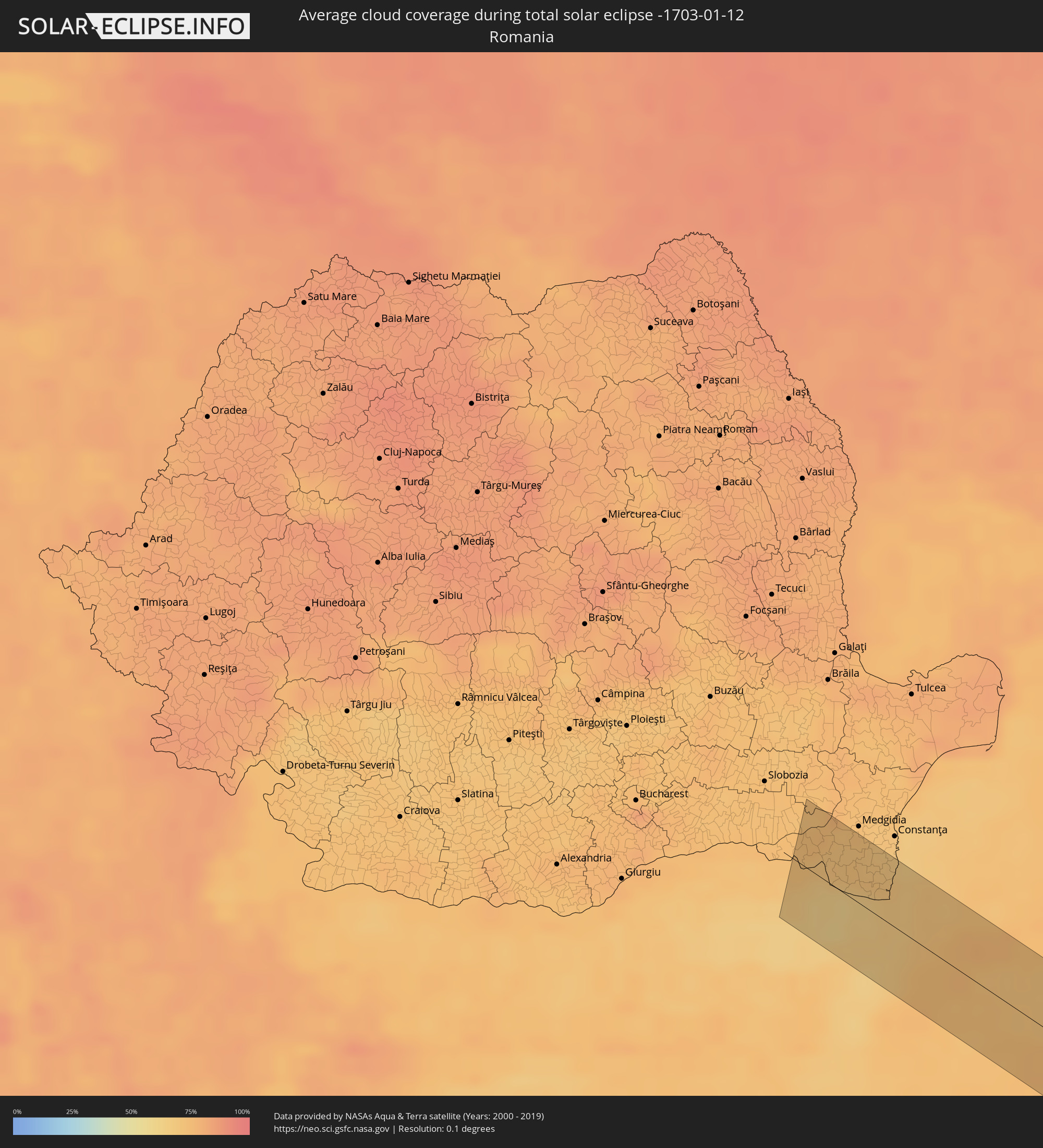 Romania
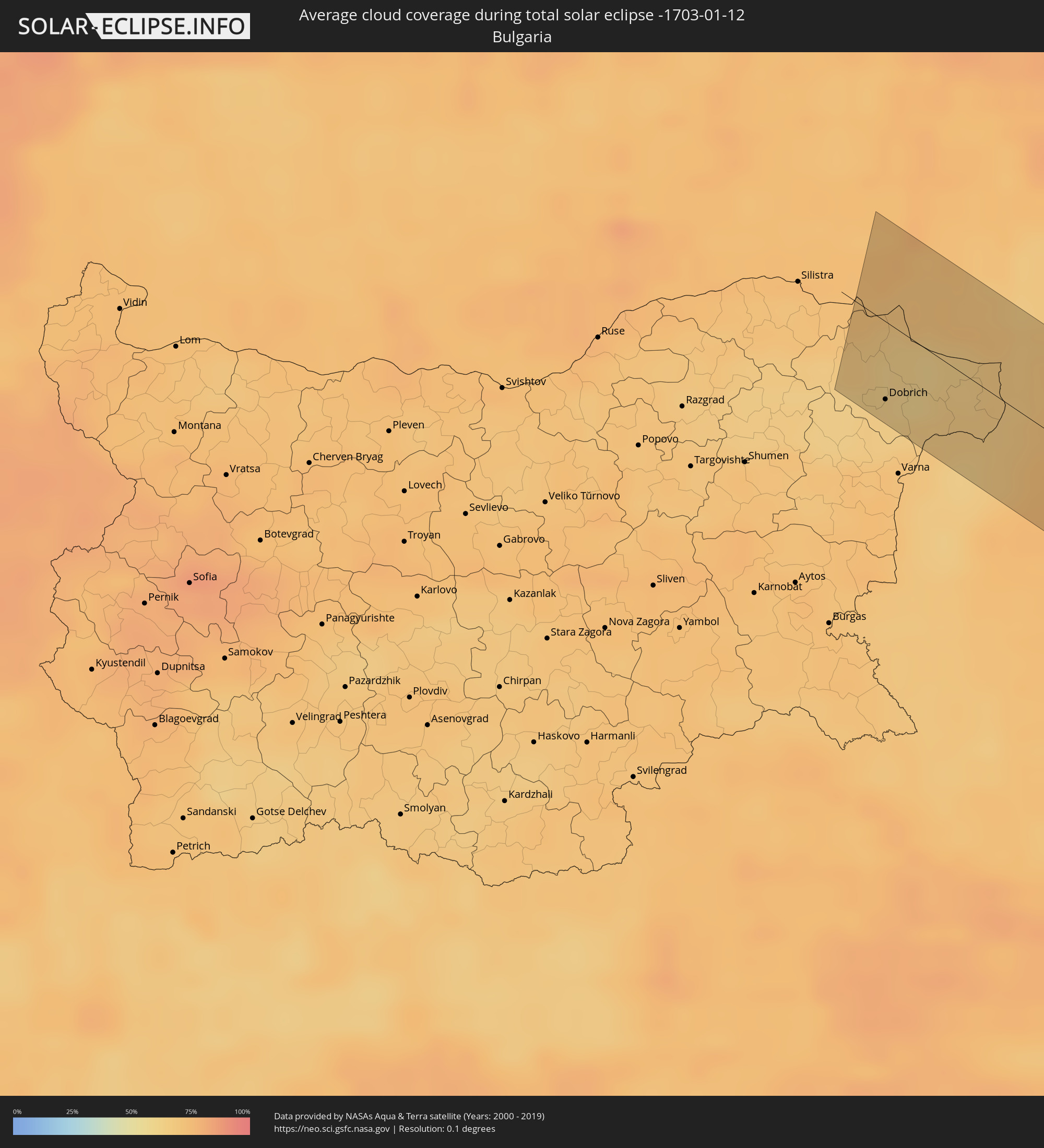 Bulgaria
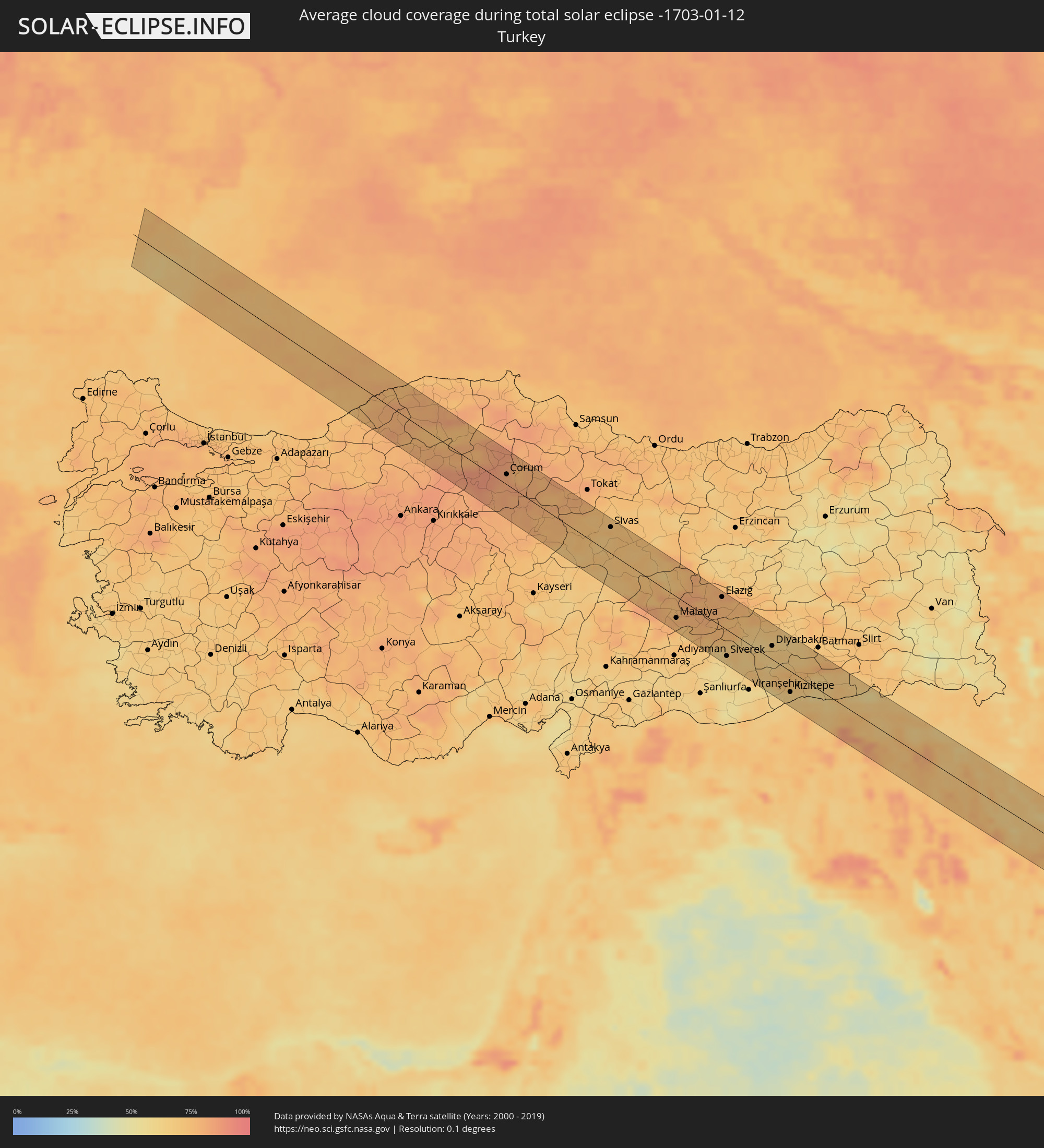 Turkey
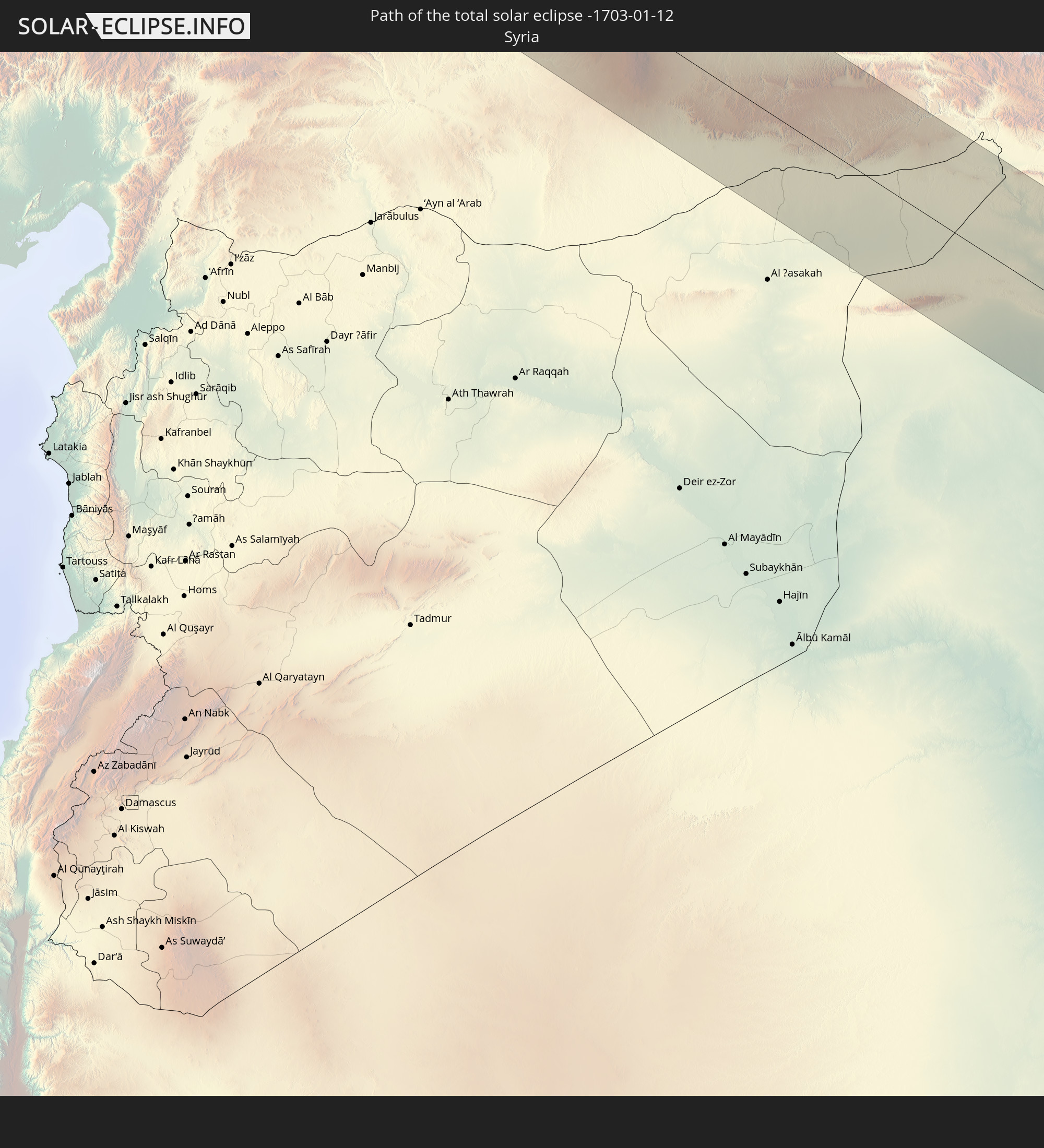
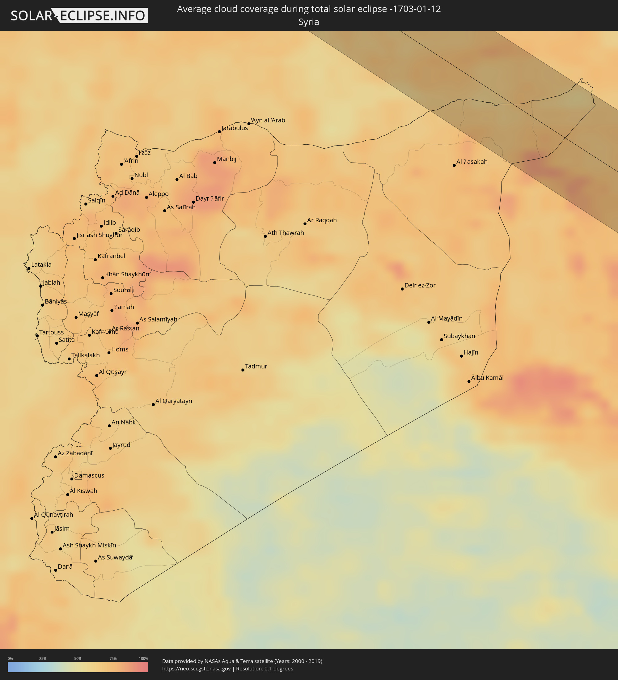 Syria
Syria
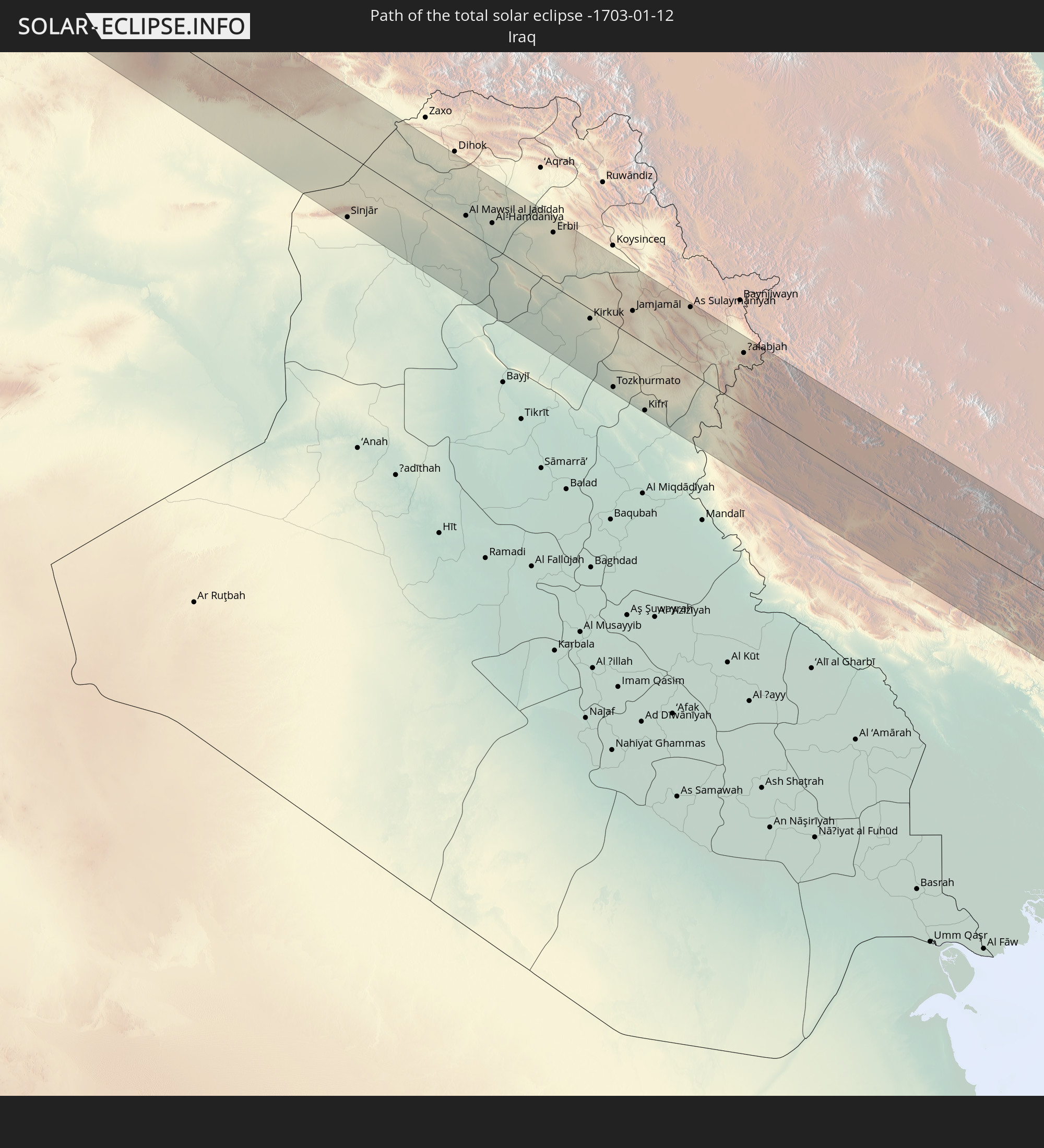
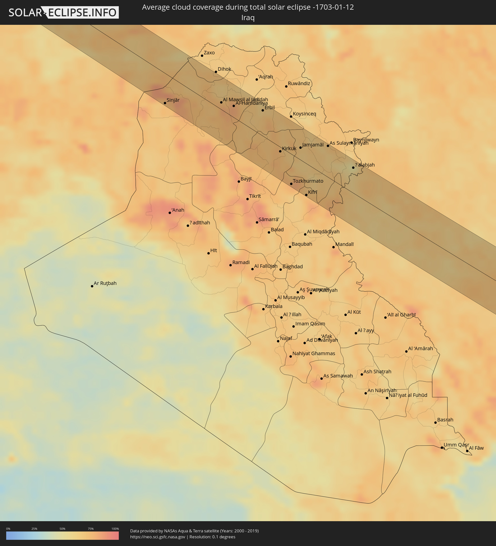 Iraq
Iraq
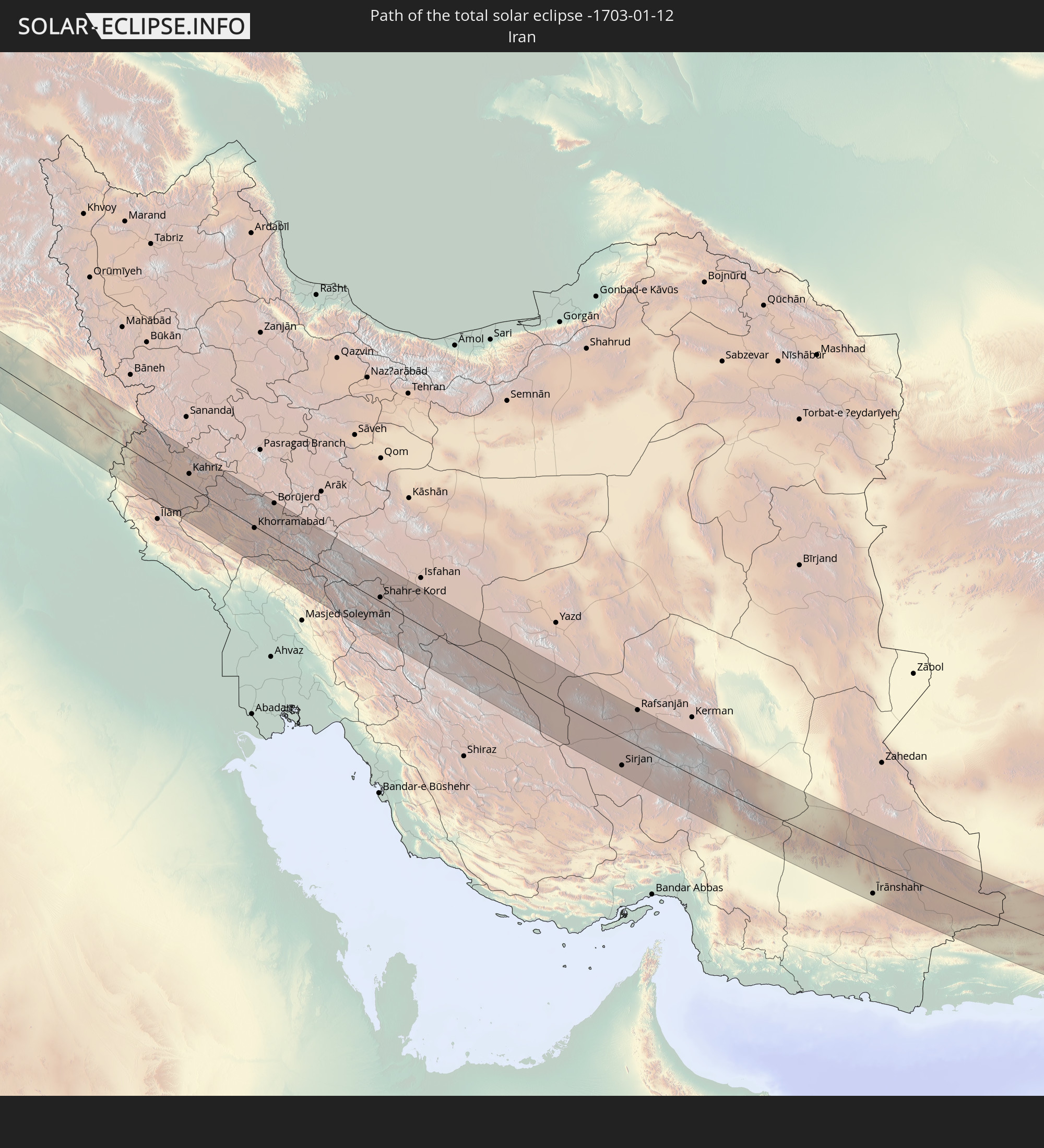
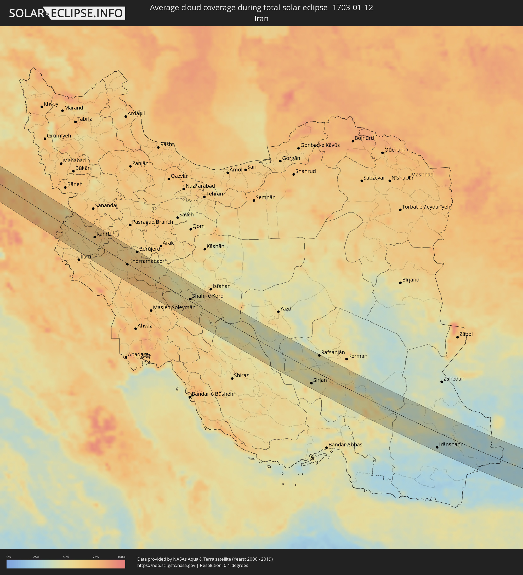 Iran
Iran
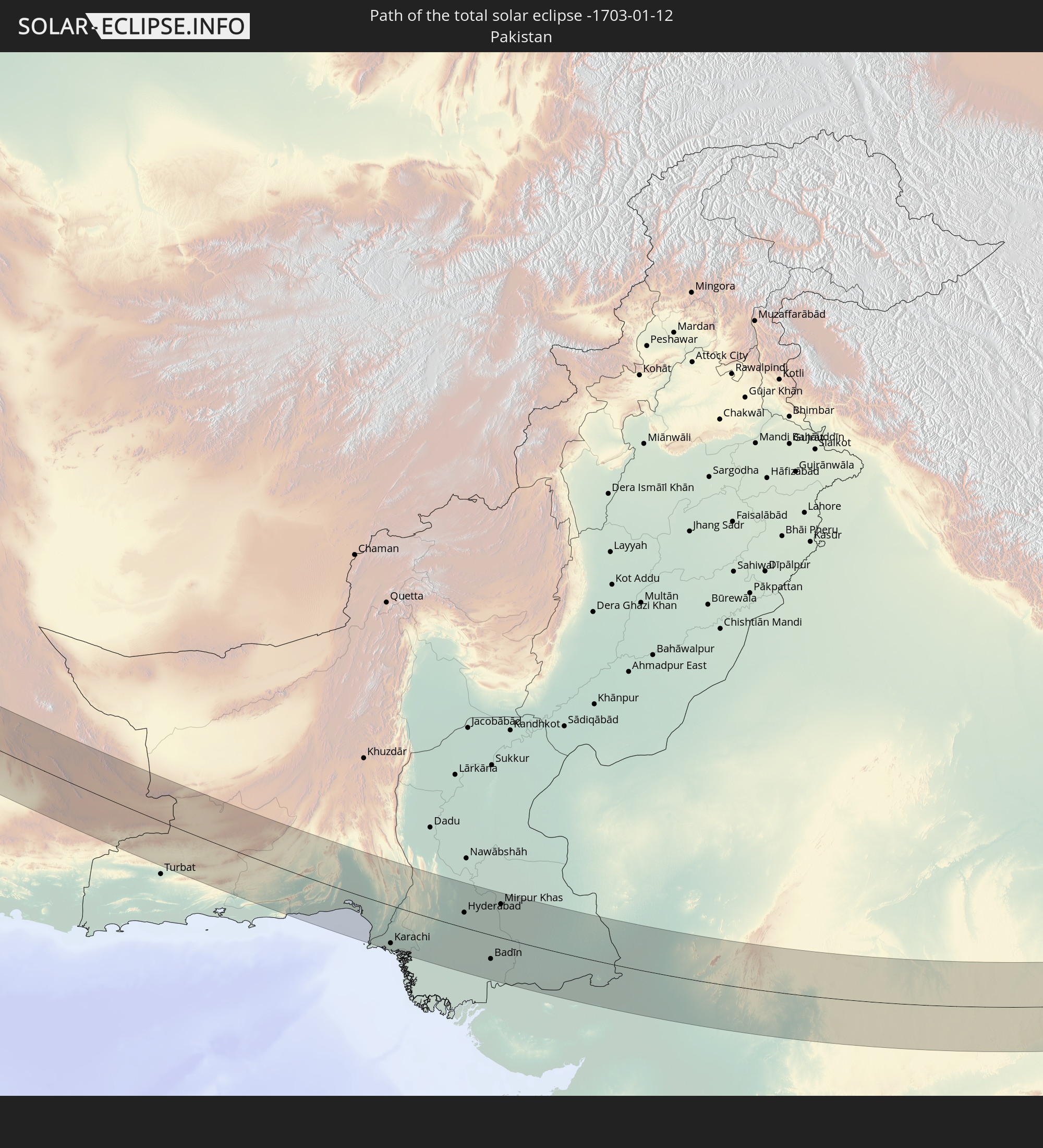
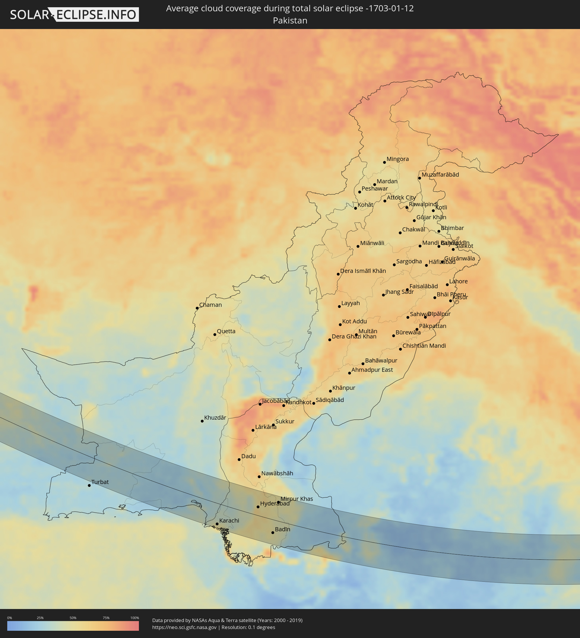 Pakistan
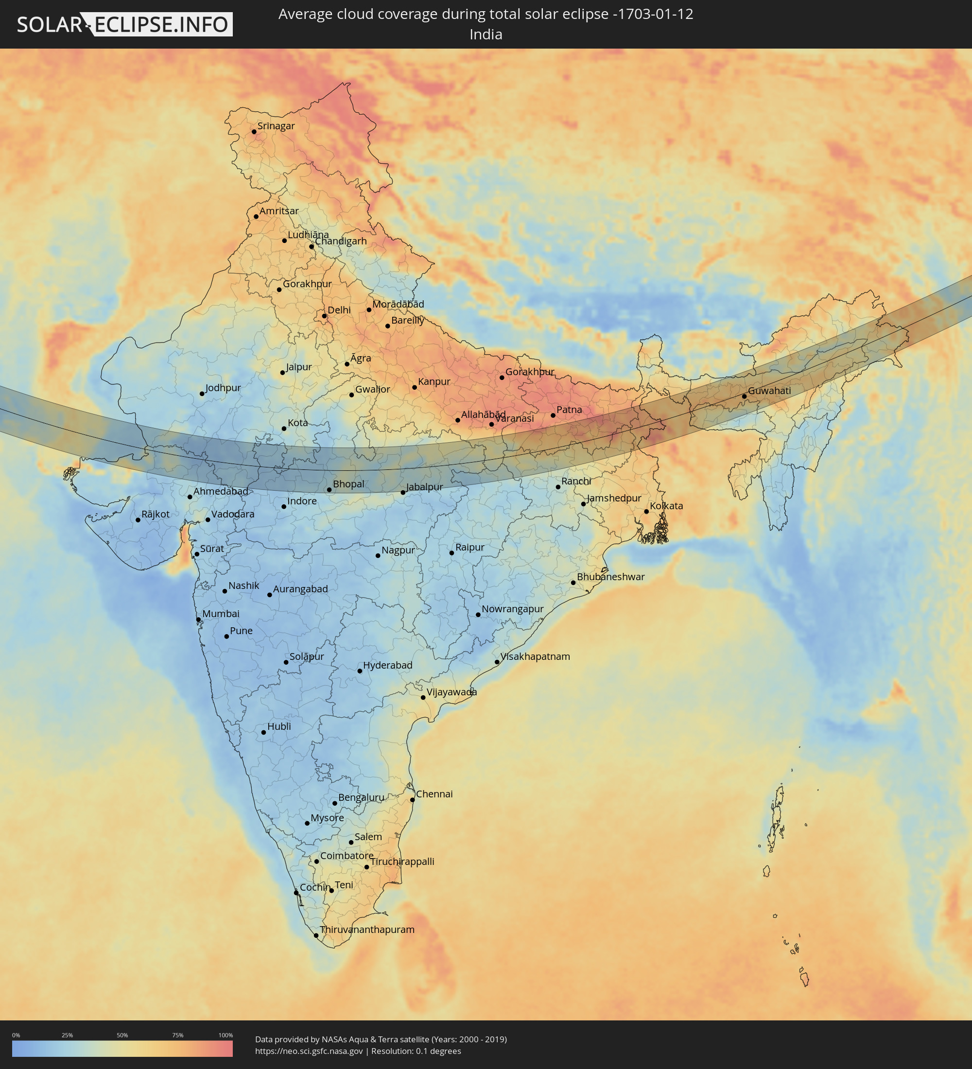 India
India
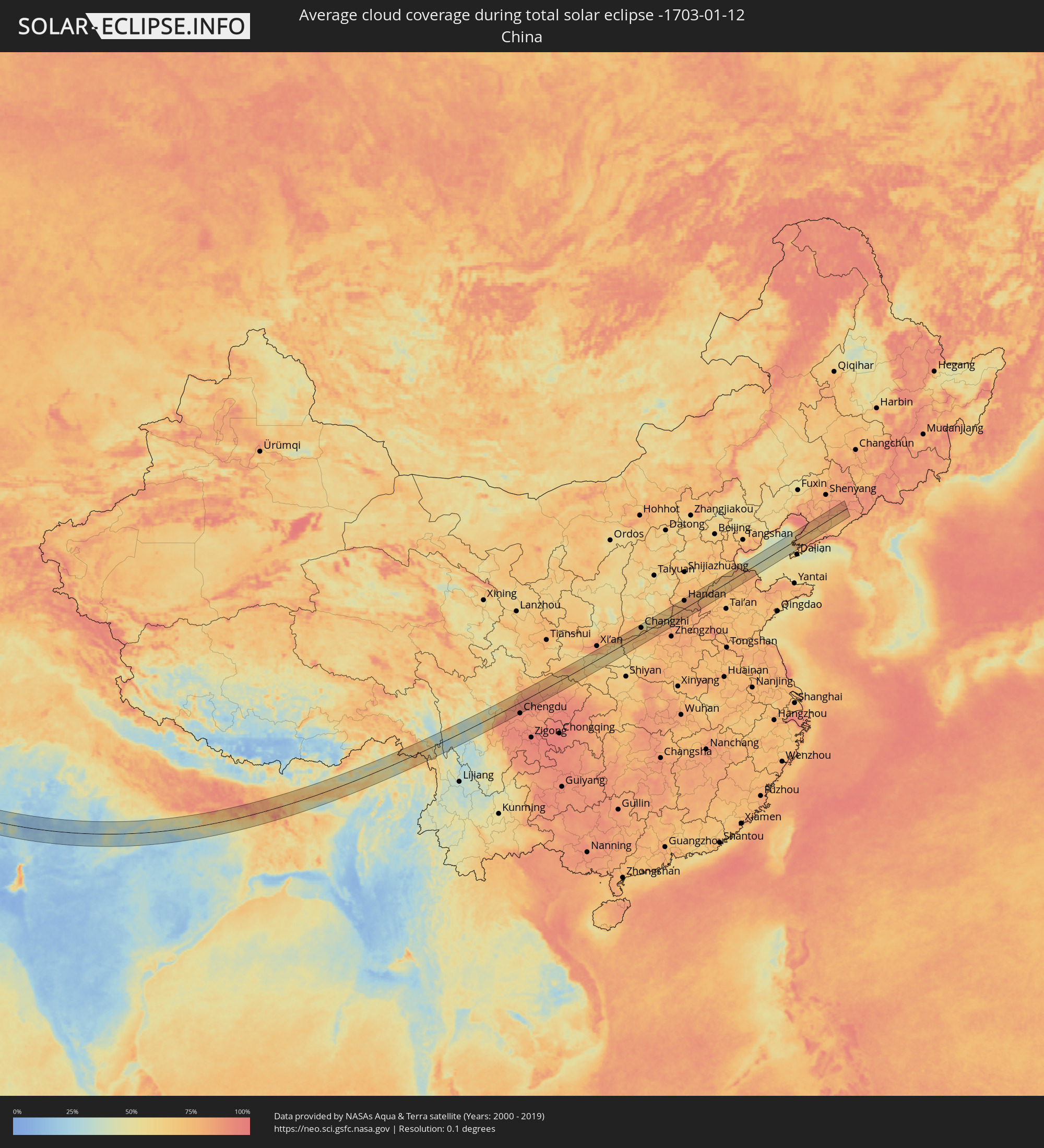 China
China
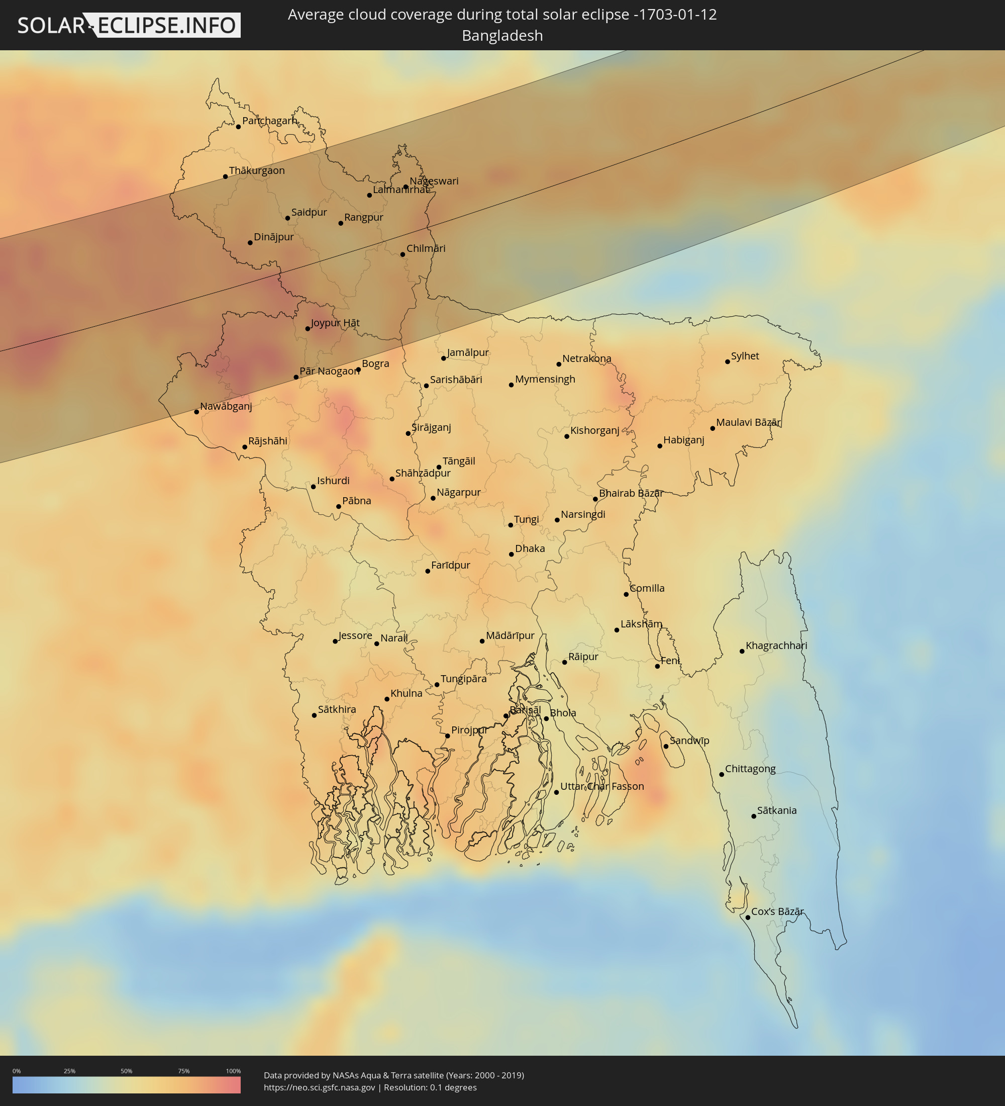 Bangladesh
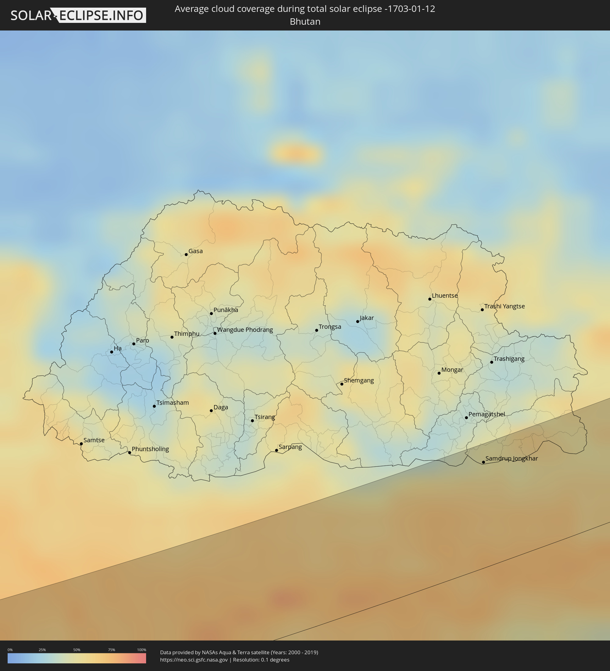 Bhutan
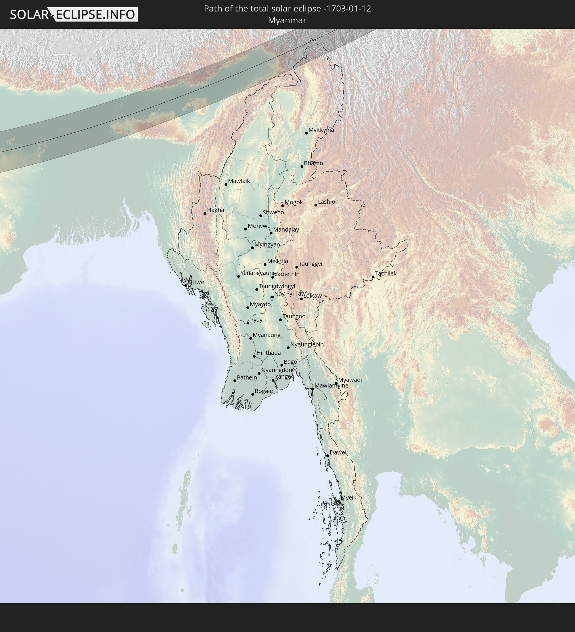
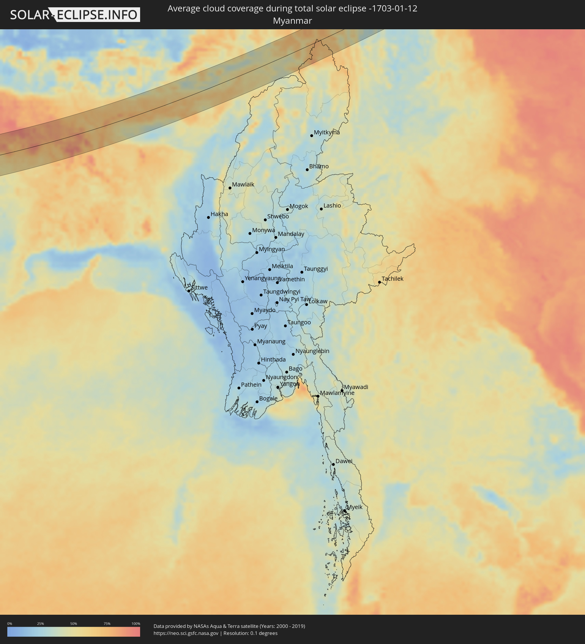 Myanmar
Cities inside the path of the eclipse
The following table shows all locations with a population of more than 5,000 inside the eclipse path. Cities which have more than 100,000 inhabitants are marked bold. A click at the locations opens a detailed map.
| City | Type | Eclipse duration | Local time of max. eclipse | Distance to central line | Ø Cloud coverage |
|
Băneasa, Constanța
|
total | - | 07:45:57 UTC+01:44 | 7 km | 72% |
|
Borcea, Călăraşi
|
total | - | 07:46:16 UTC+01:44 | 34 km | 74% |
|
Feteşti, Ialomiţa
|
total | - | 07:46:22 UTC+01:44 | 42 km | 72% |
|
Dobrich, Dobrich
|
total | - | 08:01:04 UTC+02:00 | 34 km | 63% |
|
General-Toshevo, Dobrich
|
total | - | 08:01:19 UTC+02:00 | 12 km | 61% |
|
Balchik, Dobrich
|
total | - | 08:01:05 UTC+02:00 | 33 km | 66% |
|
Negru Vodă, Constanța
|
total | - | 07:45:56 UTC+01:44 | 6 km | 64% |
|
Cobadin, Constanța
|
total | - | 07:46:15 UTC+01:44 | 31 km | 72% |
|
Kavarna, Dobrich
|
total | - | 08:01:12 UTC+02:00 | 24 km | 65% |
|
Topraisar, Constanța
|
total | - | 07:46:18 UTC+01:44 | 36 km | 70% |
|
Mangalia, Constanța
|
total | - | 07:46:08 UTC+01:44 | 22 km | 68% |
|
Tuzla, Constanța
|
total | - | 07:46:23 UTC+01:44 | 42 km | 70% |
|
Bartın, Bartın
|
total | - | 07:58:45 UTC+01:56 | 7 km | 78% |
|
Karabük, Karabük
|
total | - | 07:58:32 UTC+01:56 | 34 km | 79% |
|
Khanjarah, Çankırı
|
total | - | 07:58:39 UTC+01:56 | 44 km | 86% |
|
Kastamonu, Kastamonu
|
total | - | 07:59:32 UTC+01:56 | 36 km | 79% |
|
Osmancık, Çorum
|
total | - | 07:59:56 UTC+01:56 | 47 km | 85% |
|
Çorum, Çorum
|
total | - | 07:59:38 UTC+01:56 | 14 km | 83% |
|
Sorgun, Yozgat
|
total | - | 07:59:06 UTC+01:56 | 43 km | 77% |
|
Zile, Tokat
|
total | - | 08:00:09 UTC+01:56 | 35 km | 75% |
|
Sivas, Sivas
|
total | - | 08:00:35 UTC+01:56 | 37 km | 68% |
|
Malatya, Malatya
|
total | - | 08:00:30 UTC+01:56 | 31 km | 78% |
|
Elazığ, Elazığ
|
total | - | 08:01:39 UTC+01:56 | 43 km | 77% |
|
Siverek, Şanlıurfa
|
total | - | 08:00:57 UTC+01:56 | 38 km | 63% |
|
Ergani, Diyarbakır
|
total | - | 08:01:49 UTC+01:56 | 31 km | 68% |
|
Diyarbakır, Diyarbakır
|
total | - | 08:01:59 UTC+01:56 | 20 km | 66% |
|
Kızıltepe, Mardin
|
total | - | 08:01:45 UTC+01:56 | 31 km | 64% |
|
Ad Darbāsīyah, Al-Hasakah
|
total | - | 08:30:00 UTC+02:25 | 38 km | 67% |
|
Bismil, Diyarbakır
|
total | - | 08:02:23 UTC+01:56 | 35 km | 65% |
|
Mardin, Mardin
|
total | - | 08:02:01 UTC+01:56 | 11 km | 66% |
|
Nusaybin, Mardin
|
total | - | 08:02:19 UTC+01:56 | 11 km | 66% |
|
Midyat, Mardin
|
total | - | 08:02:44 UTC+01:56 | 28 km | 64% |
|
Sinjār, Nīnawá
|
total | - | 09:03:06 UTC+02:57 | 49 km | 72% |
|
Sīnah, Dahūk
|
total | - | 09:04:48 UTC+02:57 | 53 km | 68% |
|
Al Mawşil al Jadīdah, Nīnawá
|
total | - | 09:04:30 UTC+02:57 | 11 km | 80% |
|
Mosul, Nīnawá
|
total | - | 09:04:31 UTC+02:57 | 12 km | 80% |
|
Tallkayf, Nīnawá
|
total | - | 09:04:39 UTC+02:57 | 27 km | 69% |
|
Al-Hamdaniya, Nīnawá
|
total | - | 09:04:46 UTC+02:57 | 19 km | 79% |
|
Erbil, Arbīl
|
total | - | 09:05:28 UTC+02:57 | 42 km | 71% |
|
Kirkuk, At Taʼmīm
|
total | - | 09:05:23 UTC+02:57 | 7 km | 72% |
|
Tozkhurmato, Salah ad Din Governorate
|
total | - | 09:05:16 UTC+02:57 | 50 km | 75% |
|
Jamjamāl, As Sulaymānīyah
|
total | - | 09:05:59 UTC+02:57 | 20 km | 64% |
|
Kifrī, Diyālá
|
total | - | 09:05:32 UTC+02:57 | 53 km | 76% |
|
As Sulaymānīyah, As Sulaymānīyah
|
total | - | 09:06:45 UTC+02:57 | 52 km | 68% |
|
Sarpol-e Z̄ahāb, Kermānshāh
|
total | - | 09:34:40 UTC+03:25 | 31 km | 66% |
|
Ḩalabjah, As Sulaymānīyah
|
total | - | 09:07:12 UTC+02:57 | 43 km | 62% |
|
Kāmyārān, Kordestān
|
total | - | 09:36:19 UTC+03:25 | 53 km | 67% |
|
Kahrīz, Kermānshāh
|
total | - | 09:36:12 UTC+03:25 | 19 km | 69% |
|
Harsīn, Kermānshāh
|
total | - | 09:36:52 UTC+03:25 | 35 km | 64% |
|
Kūhdasht, Lorestān
|
total | - | 09:36:25 UTC+03:25 | 34 km | 64% |
|
Nūrābād, Lorestān
|
total | - | 09:37:16 UTC+03:25 | 34 km | 61% |
|
Khorramabad, Lorestān
|
total | - | 09:37:27 UTC+03:25 | 3 km | 64% |
|
Borūjerd, Lorestān
|
total | - | 09:38:17 UTC+03:25 | 55 km | 64% |
|
Alīgūdarz, Lorestān
|
total | - | 09:39:22 UTC+03:25 | 54 km | 54% |
|
Shahr-e Kord, Chahār Maḩāll va Bakhtīārī
|
total | - | 09:40:33 UTC+03:25 | 7 km | 55% |
|
Borūjen, Chahār Maḩāll va Bakhtīārī
|
total | - | 09:41:02 UTC+03:25 | 8 km | 54% |
|
Najafābād, Isfahan
|
total | - | 09:41:32 UTC+03:25 | 61 km | 63% |
|
Shāhreẕā, Isfahan
|
total | - | 09:42:02 UTC+03:25 | 27 km | 56% |
|
Ābādeh, Fars
|
total | - | 09:42:53 UTC+03:25 | 21 km | 45% |
|
Shahr-e Bābak, Kerman
|
total | - | 09:46:47 UTC+03:25 | 7 km | 50% |
|
Sirjan, Kerman
|
total | - | 09:47:34 UTC+03:25 | 47 km | 48% |
|
Rafsanjān, Kerman
|
total | - | 09:48:33 UTC+03:25 | 61 km | 47% |
|
Bam, Kerman
|
total | - | 09:52:45 UTC+03:25 | 38 km | 42% |
|
Īrānshahr, Sistan and Baluchestan
|
total | - | 09:57:11 UTC+03:25 | 55 km | 35% |
|
Bela, Balochistān
|
total | - | 11:12:57 UTC+04:28 | 52 km | 35% |
|
Karachi, Sindh
|
total | - | 11:14:49 UTC+04:28 | 64 km | 53% |
|
Thatta, Sindh
|
total | - | 11:17:01 UTC+04:28 | 56 km | 51% |
|
Hyderabad, Sindh
|
total | - | 11:18:15 UTC+04:28 | 25 km | 59% |
|
Hāla, Sindh
|
total | - | 11:18:24 UTC+04:28 | 72 km | 54% |
|
Tando Muhammad Khān, Sindh
|
total | - | 11:18:40 UTC+04:28 | 1 km | 53% |
|
Tando Jām, Sindh
|
total | - | 11:18:41 UTC+04:28 | 34 km | 52% |
|
Mātli, Sindh
|
total | - | 11:18:59 UTC+04:28 | 4 km | 50% |
|
Tando Ādam, Sindh
|
total | - | 11:19:02 UTC+04:28 | 73 km | 52% |
|
Tando Allāhyār, Sindh
|
total | - | 11:19:11 UTC+04:28 | 42 km | 53% |
|
Talhār, Sindh
|
total | - | 11:19:25 UTC+04:28 | 17 km | 49% |
|
Badīn, Sindh
|
total | - | 11:19:28 UTC+04:28 | 41 km | 49% |
|
Mirpur Khas, Sindh
|
total | - | 11:19:58 UTC+04:28 | 57 km | 46% |
|
Digri, Sindh
|
total | - | 11:20:13 UTC+04:28 | 20 km | 41% |
|
Naukot, Sindh
|
total | - | 11:21:00 UTC+04:28 | 5 km | 38% |
|
Kunri, Sindh
|
total | - | 11:21:27 UTC+04:28 | 34 km | 44% |
|
Dhoro Naro, Sindh
|
total | - | 11:21:28 UTC+04:28 | 69 km | 44% |
|
Umarkot, Sindh
|
total | - | 11:21:55 UTC+04:28 | 58 km | 37% |
|
Mithi, Sindh
|
total | - | 11:22:04 UTC+04:28 | 8 km | 23% |
|
Udaipur, Rajasthan
|
total | - | 12:25:53 UTC+05:21 | 47 km | 19% |
|
Ratlām, Madhya Pradesh
|
total | - | 12:29:51 UTC+05:21 | 75 km | 19% |
|
Bhopal, Madhya Pradesh
|
total | - | 12:36:39 UTC+05:21 | 71 km | 30% |
|
Saugor, Madhya Pradesh
|
total | - | 12:40:23 UTC+05:21 | 7 km | 27% |
|
Murwāra, Madhya Pradesh
|
total | - | 12:45:05 UTC+05:21 | 15 km | 31% |
|
Satna, Madhya Pradesh
|
total | - | 12:46:09 UTC+05:21 | 64 km | 47% |
|
Rewa, Madhya Pradesh
|
total | - | 12:47:27 UTC+05:21 | 54 km | 45% |
|
Singrauli, Madhya Pradesh
|
total | - | 12:51:22 UTC+05:21 | 1 km | 45% |
|
Gaya, Bihar
|
total | - | 12:57:29 UTC+05:21 | 25 km | 69% |
|
Hazārībāg, Jharkhand
|
total | - | 12:58:40 UTC+05:21 | 69 km | 38% |
|
Bihār Sharīf, Bihar
|
total | - | 12:58:44 UTC+05:21 | 58 km | 74% |
|
Monghyr, Bihar
|
total | - | 13:01:08 UTC+05:21 | 55 km | 84% |
|
Bhāgalpur, Bihar
|
total | - | 13:02:27 UTC+05:21 | 29 km | 83% |
|
Purnia, Bihar
|
total | - | 13:03:32 UTC+05:21 | 73 km | 80% |
|
Katihar, Bihar
|
total | - | 13:03:52 UTC+05:21 | 45 km | 82% |
|
Rāiganj, West Bengal
|
total | - | 13:05:13 UTC+05:21 | 38 km | 83% |
|
Ingrāj Bāzār, West Bengal
|
total | - | 13:05:29 UTC+05:21 | 28 km | 70% |
|
Shibganj, Rājshāhi
|
total | - | 13:37:48 UTC+05:53 | 62 km | 70% |
|
Pīrgaaj, Rangpur Division
|
total | - | 13:37:52 UTC+05:53 | 57 km | 74% |
|
Dinājpur, Rangpur Division
|
total | - | 13:38:39 UTC+05:53 | 25 km | 84% |
|
Bālurghāt, West Bengal
|
total | - | 13:06:58 UTC+05:21 | 22 km | 83% |
|
Saidpur, Rājshāhi
|
total | - | 13:39:12 UTC+05:53 | 34 km | 72% |
|
Parbatipur, Rangpur Division
|
total | - | 13:39:21 UTC+05:53 | 21 km | 81% |
|
Pār Naogaon, Rājshāhi
|
total | - | 13:39:42 UTC+05:53 | 72 km | 80% |
|
Joypur Hāt, Rājshāhi
|
total | - | 13:39:47 UTC+05:53 | 42 km | 71% |
|
Badarganj, Rangpur Division
|
total | - | 13:39:38 UTC+05:53 | 18 km | 69% |
|
Rangpur, Rangpur Division
|
total | - | 13:40:05 UTC+05:53 | 20 km | 61% |
|
Lalmanirhat, Rangpur Division
|
total | - | 13:40:29 UTC+05:53 | 32 km | 70% |
|
Chilmāri, Rangpur Division
|
total | - | 13:41:10 UTC+05:53 | 13 km | 75% |
|
Nageswari, Rangpur Division
|
total | - | 13:41:03 UTC+05:53 | 30 km | 69% |
|
Samdrup Jongkhar, Samdrup Jongkhar
|
total | - | 13:50:11 UTC+05:58 | 59 km | 56% |
|
Guwahati, Assam
|
total | - | 13:13:34 UTC+05:21 | 14 km | 63% |
|
Deyang, Sichuan
|
total | - | 16:12:53 UTC+08:00 | 28 km | 92% |
|
Mianyang, Sichuan
|
total | - | 16:13:04 UTC+08:00 | 8 km | 90% |
|
Jiangyou, Sichuan
|
total | - | 16:12:54 UTC+08:00 | 20 km | 88% |
|
Guangyuan, Sichuan
|
total | - | 16:13:56 UTC+08:00 | 36 km | 80% |
|
Hanzhong, Shaanxi
|
total | - | 16:15:02 UTC+08:00 | 42 km | 85% |
|
Huayin, Shaanxi
|
total | - | 16:17:28 UTC+08:00 | 46 km | 77% |
|
Yuncheng, Shanxi
|
total | - | 16:18:06 UTC+08:00 | 47 km | 76% |
|
Changzhi, Shanxi
|
total | - | 16:18:44 UTC+08:00 | 31 km | 72% |
|
Jincheng, Shanxi
|
total | - | 16:19:36 UTC+08:00 | 8 km | 69% |
|
Jiaozuo, Henan
|
total | - | 16:20:14 UTC+08:00 | 35 km | 80% |
|
Hebi, Henan
|
total | - | 16:20:33 UTC+08:00 | 17 km | 80% |
|
Linshui, Hebei
|
total | - | 16:20:04 UTC+08:00 | 33 km | 77% |
|
Anyang, Henan
|
total | - | 16:20:32 UTC+08:00 | 7 km | 80% |
|
Handan, Hebei
|
total | - | 16:20:08 UTC+08:00 | 37 km | 79% |
|
Qingnian, Shandong
|
total | - | 16:21:02 UTC+08:00 | 3 km | 74% |
|
Liaocheng, Shandong
|
total | - | 16:21:38 UTC+08:00 | 46 km | 77% |
|
Dezhou, Shandong
|
total | - | 16:20:57 UTC+08:00 | 33 km | 71% |
|
Wafangdian, Liaoning
|
total | - | 16:22:53 UTC+08:00 | 22 km | 73% |
|
Fengcheng, Liaoning
|
total | - | 16:23:12 UTC+08:00 | 36 km | 72% |