Total solar eclipse of 06/03/-1868
| Day of week: | Sunday |
| Maximum duration of eclipse: | 05m17s |
| Maximum width of eclipse path: | 227 km |
| Saros cycle: | 17 |
| Coverage: | 100% |
| Magnitude: | 1.0667 |
| Gamma: | 0.29 |
Wo kann man die Sonnenfinsternis vom 06/03/-1868 sehen?
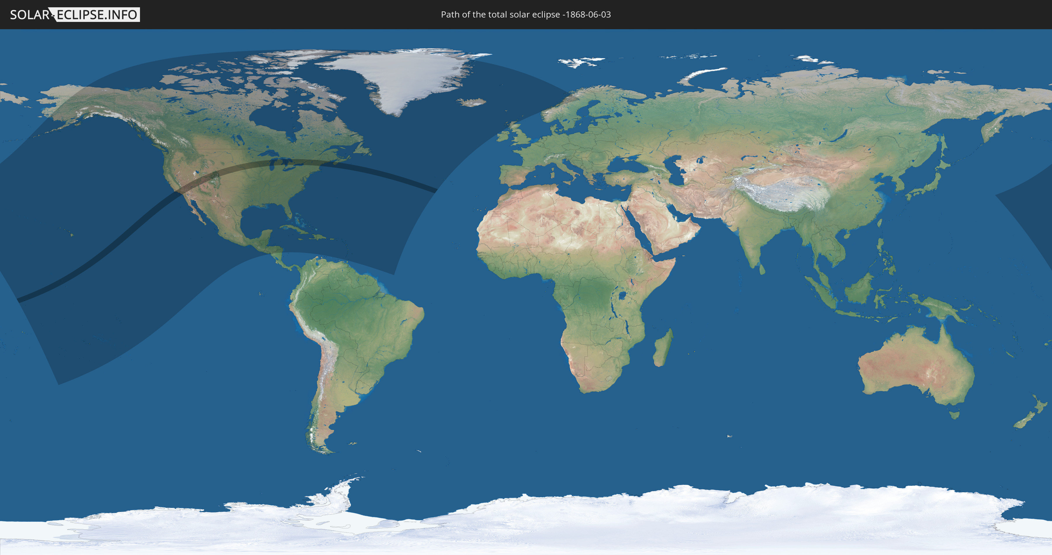
Die Sonnenfinsternis am 06/03/-1868 kann man in 48 Ländern als partielle Sonnenfinsternis beobachten.
Der Finsternispfad verläuft durch 3 Länder. Nur in diesen Ländern ist sie als total Sonnenfinsternis zu sehen.
In den folgenden Ländern ist die Sonnenfinsternis total zu sehen
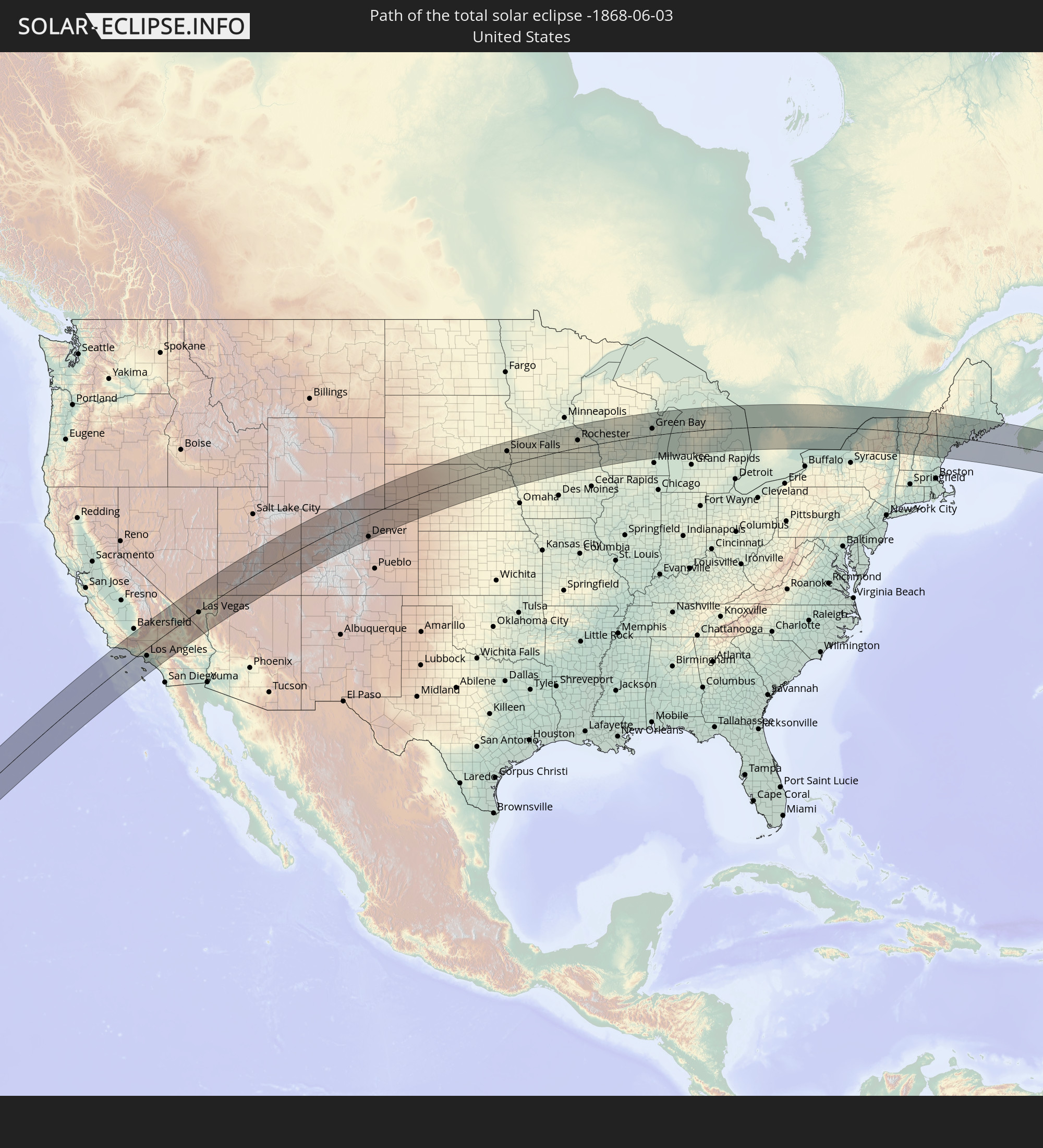 United States
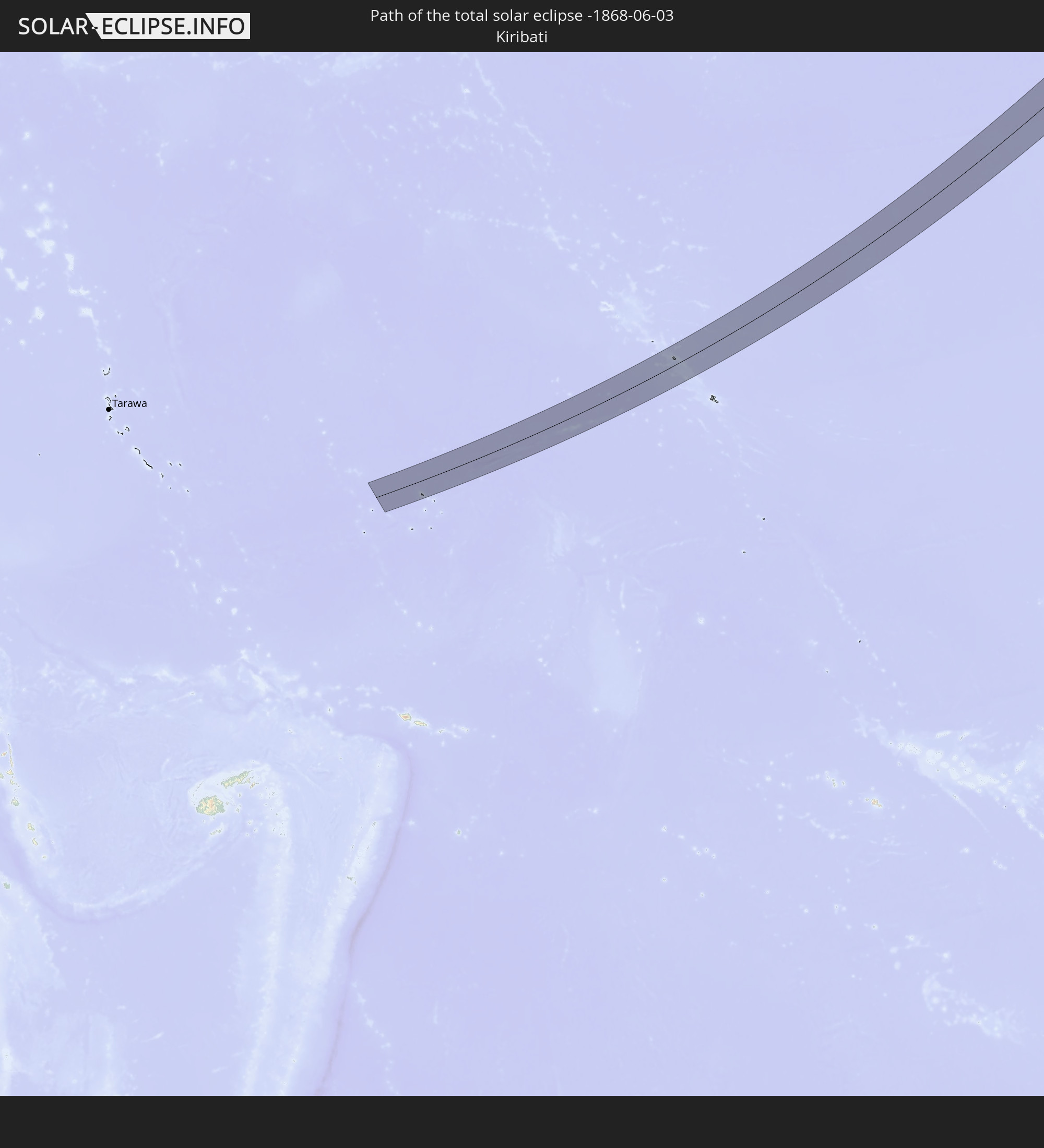 Kiribati
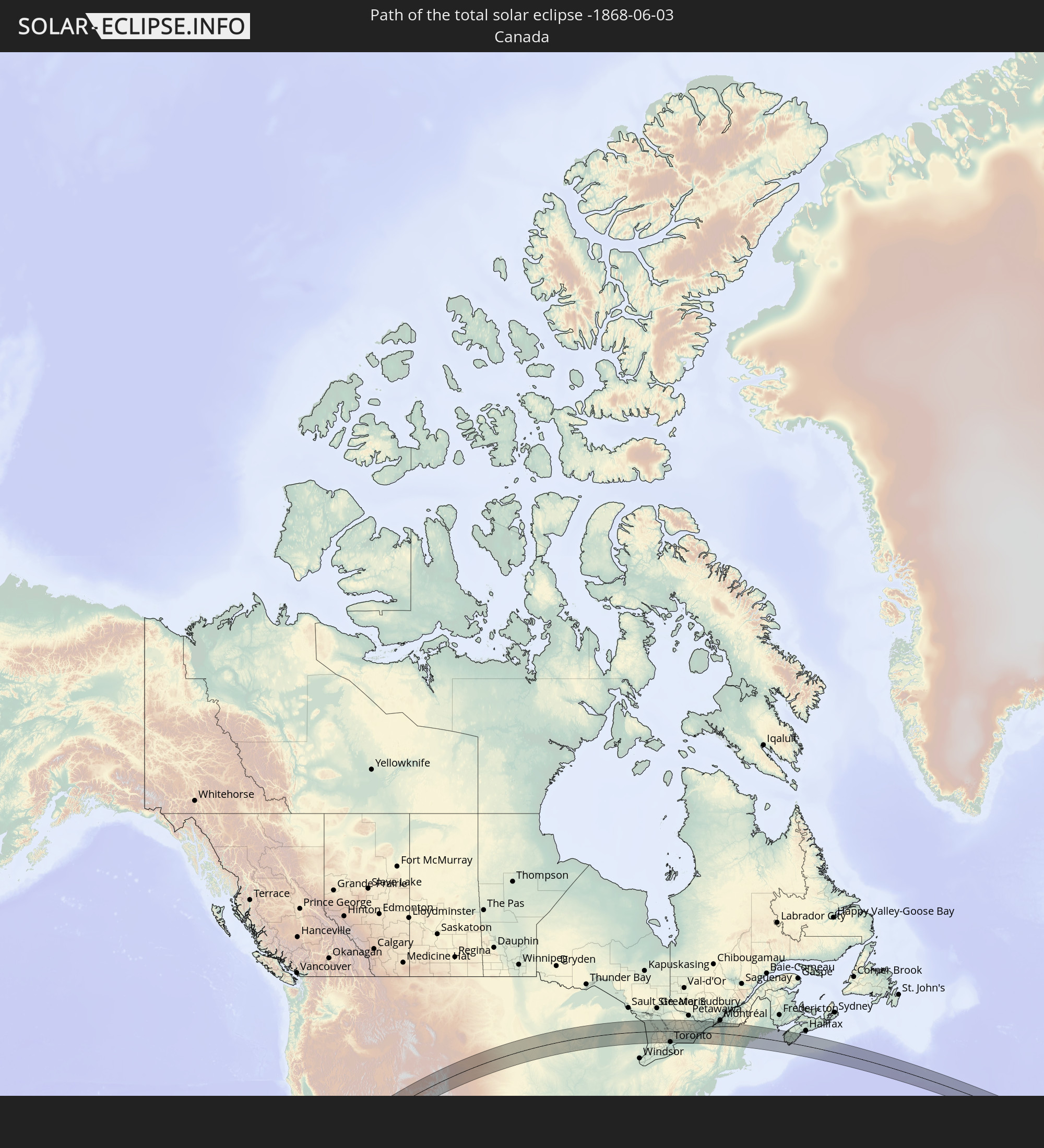 Canada
In den folgenden Ländern ist die Sonnenfinsternis partiell zu sehen
 United States
 United States Minor Outlying Islands
 Kiribati
 Cook Islands
 French Polynesia
 Canada
 Mexico
 Greenland
 Guatemala
 El Salvador
 Honduras
 Belize
 Nicaragua
 Cuba
Cuba
 Cayman Islands
 The Bahamas
 Jamaica
 Haiti
Haiti
 Venezuela
 Turks and Caicos Islands
 Dominican Republic
 Puerto Rico
 United States Virgin Islands
 Bermuda
 British Virgin Islands
 Anguilla
 Collectivity of Saint Martin
 Saint Barthélemy
 Saint Kitts and Nevis
 Antigua and Barbuda
 Montserrat
 Trinidad and Tobago
 Guadeloupe
 Grenada
 Dominica
 Saint Vincent and the Grenadines
 Martinique
 Saint Lucia
 Barbados
 Saint Pierre and Miquelon
 Portugal
 Iceland
 Republic of Ireland
 Svalbard and Jan Mayen
 United Kingdom
 Faroe Islands
 Norway
 Sweden
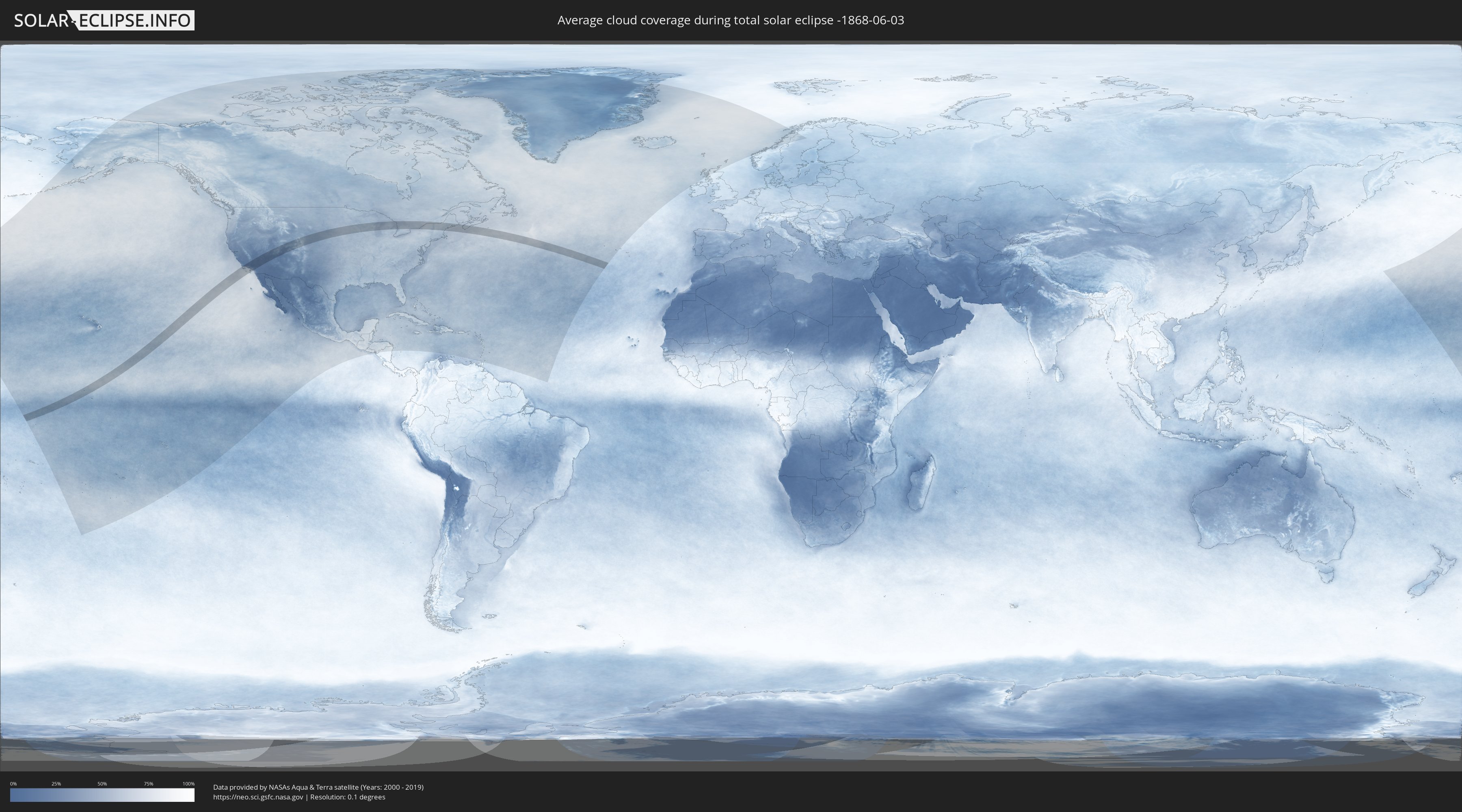
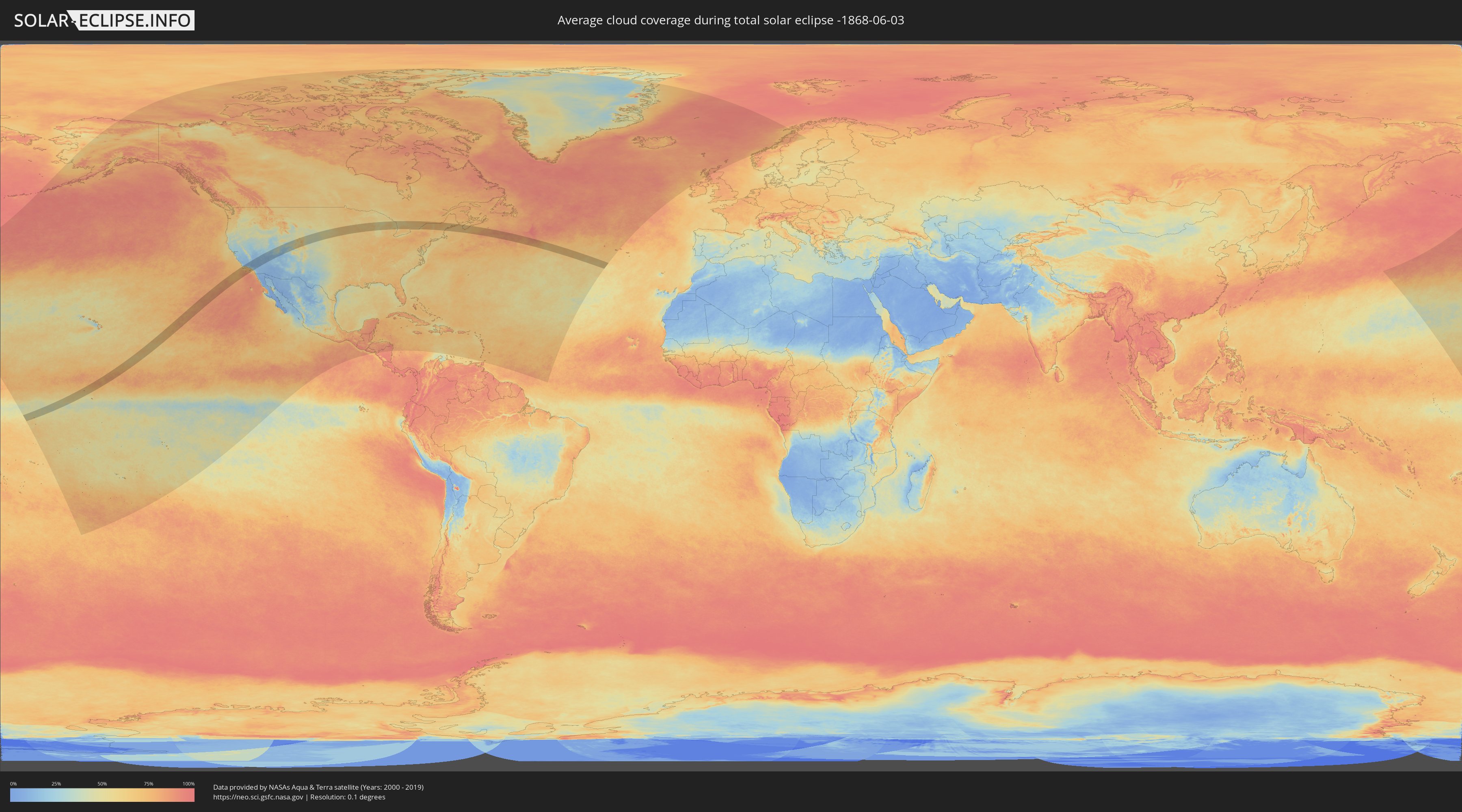
How will be the weather during the total solar eclipse on 06/03/-1868?
Where is the best place to see the total solar eclipse of 06/03/-1868?
The following maps show the average cloud coverage for the day of the total solar eclipse.
With the help of these maps, it is possible to find the place along the eclipse path, which has the best
chance of a cloudless sky.
Nevertheless, you should consider local circumstances and inform about the weather of your chosen
observation site.
The data is provided by NASAs satellites
AQUA and TERRA.
The cloud maps are averaged over a period of 19 years (2000 - 2019).
Detailed country maps
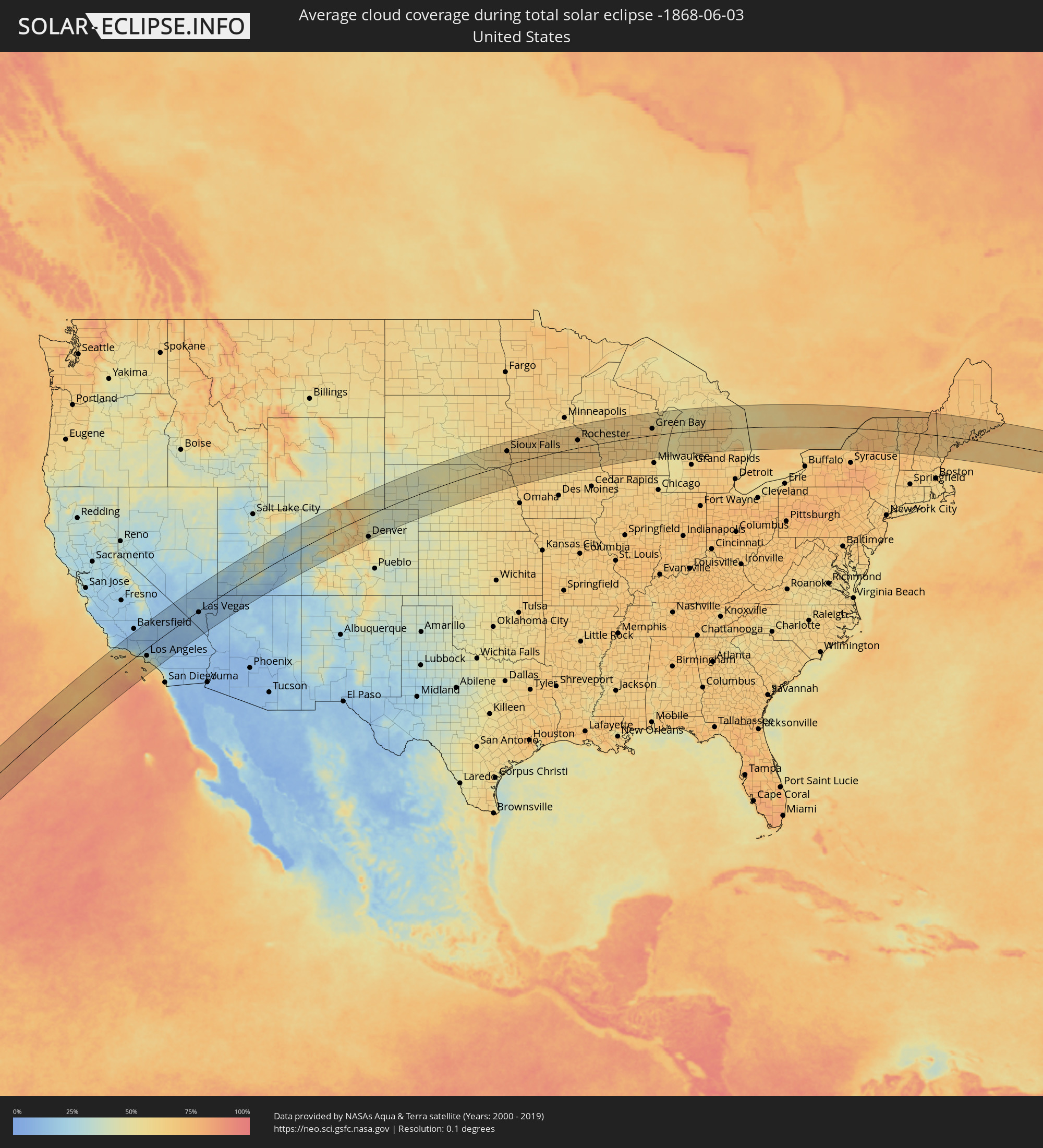 United States
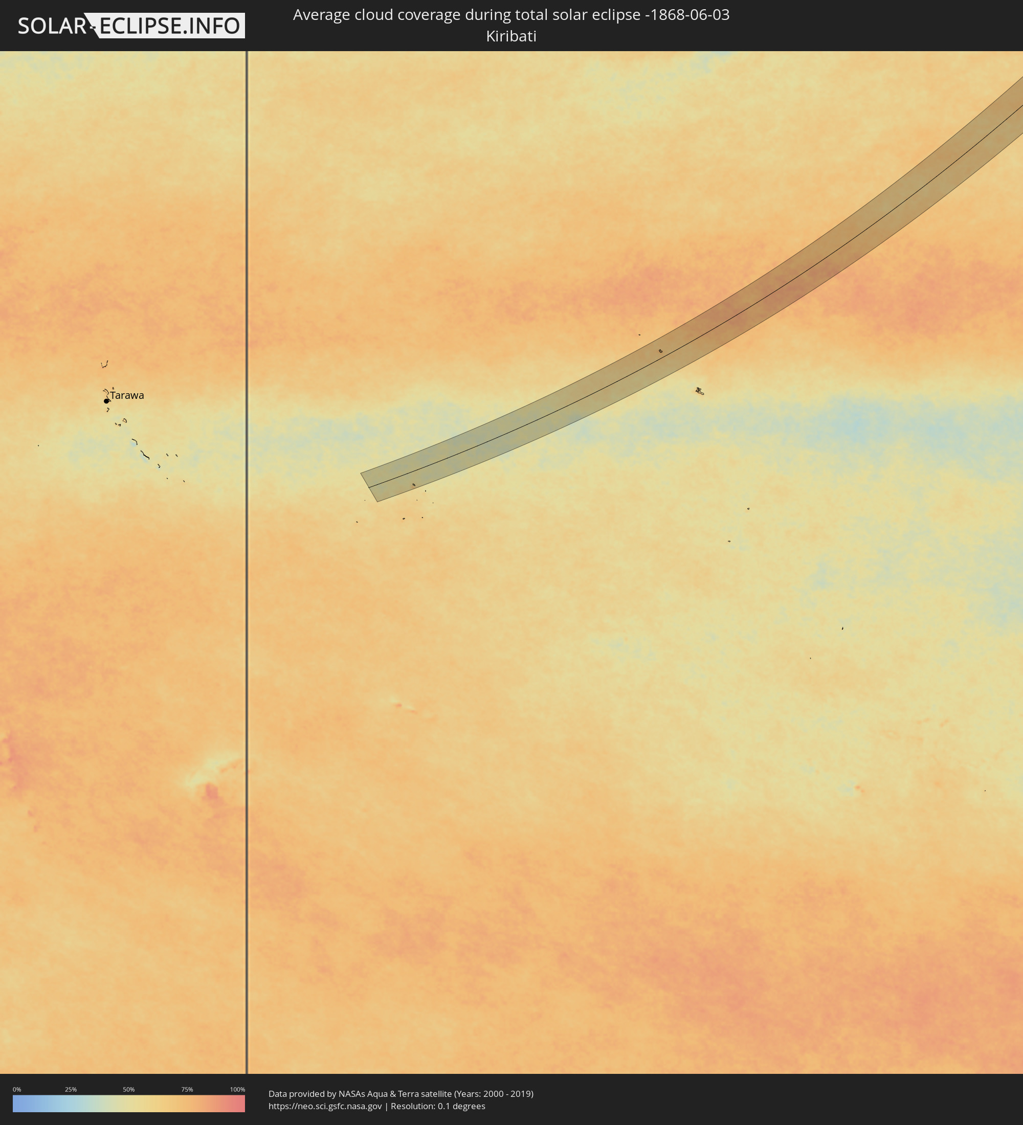 Kiribati
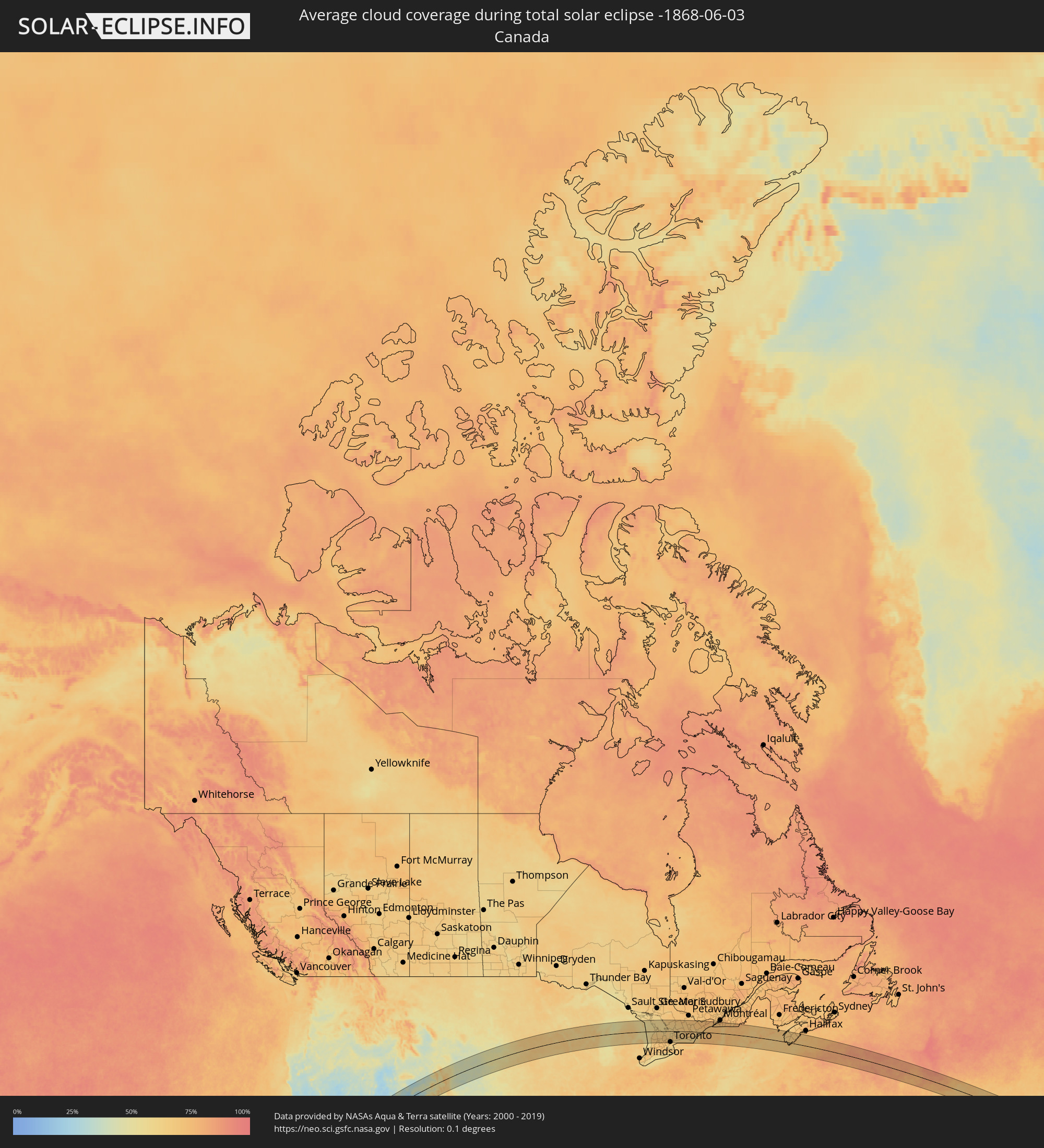 Canada
Cities inside the path of the eclipse
The following table shows all locations with a population of more than 5,000 inside the eclipse path. Cities which have more than 100,000 inhabitants are marked bold. A click at the locations opens a detailed map.
| City | Type | Eclipse duration | Local time of max. eclipse | Distance to central line | Ø Cloud coverage |
|
Santa Barbara, California
|
total | - | 11:02:15 UTC-08:00 | 81 km | 68% |
|
Oxnard, California
|
total | - | 11:02:48 UTC-08:00 | 32 km | 67% |
|
Santa Paula, California
|
total | - | 11:03:16 UTC-08:00 | 39 km | 35% |
|
Thousand Oaks, California
|
total | - | 11:03:22 UTC-08:00 | 11 km | 30% |
|
Arvin, California
|
total | - | 11:05:02 UTC-08:00 | 102 km | 14% |
|
West Hills, California
|
total | - | 11:03:45 UTC-08:00 | 2 km | 28% |
|
Santa Clarita, California
|
total | - | 11:04:15 UTC-08:00 | 14 km | 22% |
|
Santa Monica, California
|
total | - | 11:03:44 UTC-08:00 | 22 km | 61% |
|
Van Nuys, California
|
total | - | 11:04:05 UTC-08:00 | 10 km | 29% |
|
Torrance, California
|
total | - | 11:03:43 UTC-08:00 | 47 km | 55% |
|
Los Angeles, California
|
total | - | 11:04:14 UTC-08:00 | 33 km | 32% |
|
Long Beach, California
|
total | - | 11:03:52 UTC-08:00 | 61 km | 55% |
|
Rosamond, California
|
total | - | 11:05:40 UTC-08:00 | 35 km | 10% |
|
Lancaster, California
|
total | - | 11:05:27 UTC-08:00 | 19 km | 9% |
|
Downey, California
|
total | - | 11:04:15 UTC-08:00 | 49 km | 42% |
|
Altadena, California
|
total | - | 11:04:39 UTC-08:00 | 27 km | 28% |
|
Vincent, California
|
total | - | 11:05:11 UTC-08:00 | 0 km | 13% |
|
El Monte, California
|
total | - | 11:04:39 UTC-08:00 | 43 km | 31% |
|
Huntington Beach, California
|
total | - | 11:04:03 UTC-08:00 | 81 km | 60% |
|
Anaheim, California
|
total | - | 11:04:29 UTC-08:00 | 70 km | 41% |
|
Rowland Heights, California
|
total | - | 11:04:43 UTC-08:00 | 58 km | 34% |
|
Irvine, California
|
total | - | 11:04:23 UTC-08:00 | 90 km | 43% |
|
Pomona, California
|
total | - | 11:05:08 UTC-08:00 | 60 km | 27% |
|
Mission Viejo, California
|
total | - | 11:04:33 UTC-08:00 | 105 km | 45% |
|
Ridgecrest, California
|
total | - | 11:07:43 UTC-08:00 | 76 km | 13% |
|
Rancho Cucamonga, California
|
total | - | 11:05:30 UTC-08:00 | 64 km | 24% |
|
Corona, California
|
total | - | 11:05:11 UTC-08:00 | 86 km | 23% |
|
Riverside, California
|
total | - | 11:05:37 UTC-08:00 | 89 km | 20% |
|
Victorville, California
|
total | - | 11:06:43 UTC-08:00 | 42 km | 13% |
|
San Bernardino, California
|
total | - | 11:06:03 UTC-08:00 | 80 km | 16% |
|
Moreno Valley, California
|
total | - | 11:05:53 UTC-08:00 | 99 km | 14% |
|
Perris, California
|
total | - | 11:05:39 UTC-08:00 | 113 km | 13% |
|
Barstow Heights, California
|
total | - | 11:07:40 UTC-08:00 | 25 km | 12% |
|
Yucaipa, California
|
total | - | 11:06:23 UTC-08:00 | 101 km | 13% |
|
Pahrump, Nevada
|
total | - | 11:11:38 UTC-08:00 | 40 km | 13% |
|
Enterprise, Nevada
|
total | - | 11:12:43 UTC-08:00 | 15 km | 14% |
|
Las Vegas, Nevada
|
total | - | 11:13:07 UTC-08:00 | 6 km | 15% |
|
Henderson, Nevada
|
total | - | 11:13:13 UTC-08:00 | 27 km | 15% |
|
Mesquite, Nevada
|
total | - | 11:15:59 UTC-08:00 | 1 km | 14% |
|
Saint George, Utah
|
total | - | 12:17:17 UTC-07:00 | 3 km | 15% |
|
Cedar City, Utah
|
total | - | 12:19:00 UTC-07:00 | 32 km | 21% |
|
Grand Junction, Colorado
|
total | - | 12:29:00 UTC-07:00 | 32 km | 34% |
|
Laramie, Wyoming
|
total | - | 12:36:33 UTC-07:00 | 81 km | 52% |
|
Boulder, Colorado
|
total | - | 12:36:01 UTC-07:00 | 62 km | 57% |
|
Golden, Colorado
|
total | - | 12:35:53 UTC-07:00 | 90 km | 52% |
|
Longmont, Colorado
|
total | - | 12:36:28 UTC-07:00 | 52 km | 46% |
|
Broomfield, Colorado
|
total | - | 12:36:17 UTC-07:00 | 78 km | 47% |
|
Fort Collins, Colorado
|
total | - | 12:36:51 UTC-07:00 | 10 km | 50% |
|
Loveland, Colorado
|
total | - | 12:36:43 UTC-07:00 | 30 km | 47% |
|
Denver, Colorado
|
total | - | 12:36:19 UTC-07:00 | 100 km | 46% |
|
Windsor, Colorado
|
total | - | 12:37:06 UTC-07:00 | 28 km | 43% |
|
Brighton, Colorado
|
total | - | 12:36:50 UTC-07:00 | 80 km | 45% |
|
Cheyenne, Wyoming
|
total | - | 12:37:47 UTC-07:00 | 37 km | 46% |
|
Greeley, Colorado
|
total | - | 12:37:24 UTC-07:00 | 40 km | 41% |
|
North Platte, Nebraska
|
total | - | 13:45:05 UTC-06:00 | 92 km | 46% |
|
Norfolk, Nebraska
|
total | - | 13:51:27 UTC-06:00 | 83 km | 60% |
|
Sioux Falls, South Dakota
|
total | - | 13:53:11 UTC-06:00 | 63 km | 65% |
|
Sioux City, Iowa
|
total | - | 13:53:22 UTC-06:00 | 56 km | 64% |
|
Fort Dodge, Iowa
|
total | - | 13:57:07 UTC-06:00 | 101 km | 61% |
|
Mankato, Minnesota
|
total | - | 13:57:40 UTC-06:00 | 76 km | 64% |
|
Albert Lea, Minnesota
|
total | - | 13:58:37 UTC-06:00 | 9 km | 66% |
|
Faribault, Minnesota
|
total | - | 13:58:51 UTC-06:00 | 78 km | 63% |
|
Owatonna, Minnesota
|
total | - | 13:58:54 UTC-06:00 | 54 km | 65% |
|
Mason City, Iowa
|
total | - | 13:58:49 UTC-06:00 | 48 km | 64% |
|
Northfield, Minnesota
|
total | - | 13:59:02 UTC-06:00 | 94 km | 63% |
|
Austin, Minnesota
|
total | - | 13:59:15 UTC-06:00 | 4 km | 65% |
|
Red Wing, Minnesota
|
total | - | 14:00:01 UTC-06:00 | 95 km | 62% |
|
Rochester, Minnesota
|
total | - | 14:00:05 UTC-06:00 | 35 km | 66% |
|
Winona, Minnesota
|
total | - | 14:01:22 UTC-06:00 | 25 km | 64% |
|
Eau Claire, Wisconsin
|
total | - | 14:01:36 UTC-06:00 | 106 km | 60% |
|
La Crosse, Wisconsin
|
total | - | 14:01:59 UTC-06:00 | 8 km | 60% |
|
Marshfield, Wisconsin
|
total | - | 14:03:35 UTC-06:00 | 73 km | 66% |
|
Wisconsin Rapids, Wisconsin
|
total | - | 14:04:08 UTC-06:00 | 37 km | 60% |
|
Wausau, Wisconsin
|
total | - | 14:04:22 UTC-06:00 | 98 km | 63% |
|
Stevens Point, Wisconsin
|
total | - | 14:04:29 UTC-06:00 | 49 km | 61% |
|
Sun Prairie, Wisconsin
|
total | - | 14:05:07 UTC-06:00 | 103 km | 66% |
|
Beaver Dam, Wisconsin
|
total | - | 14:05:41 UTC-06:00 | 77 km | 65% |
|
Watertown, Wisconsin
|
total | - | 14:05:52 UTC-06:00 | 107 km | 65% |
|
Oshkosh, Wisconsin
|
total | - | 14:06:04 UTC-06:00 | 17 km | 59% |
|
Fond du Lac, Wisconsin
|
total | - | 14:06:15 UTC-06:00 | 46 km | 64% |
|
Appleton, Wisconsin
|
total | - | 14:06:13 UTC-06:00 | 7 km | 66% |
|
West Bend, Wisconsin
|
total | - | 14:06:40 UTC-06:00 | 87 km | 64% |
|
Green Bay, Wisconsin
|
total | - | 14:06:46 UTC-06:00 | 32 km | 66% |
|
Sheboygan, Wisconsin
|
total | - | 14:07:19 UTC-06:00 | 56 km | 59% |
|
Manitowoc, Wisconsin
|
total | - | 14:07:21 UTC-06:00 | 20 km | 61% |
|
Mount Pleasant, Michigan
|
total | - | 15:11:36 UTC-05:00 | 97 km | 65% |
|
Midland, Michigan
|
total | - | 15:12:19 UTC-05:00 | 98 km | 66% |
|
Bay City, Michigan
|
total | - | 15:12:49 UTC-05:00 | 102 km | 63% |
|
Goderich, Ontario
|
total | - | 15:15:41 UTC-05:00 | 94 km | 59% |
|
Kincardine, Ontario
|
total | - | 15:15:37 UTC-05:00 | 45 km | 63% |
|
Hanover, Ontario
|
total | - | 15:16:24 UTC-05:00 | 50 km | 65% |
|
North Perth, Ontario
|
total | - | 15:16:40 UTC-05:00 | 97 km | 68% |
|
Owen Sound, Ontario
|
total | - | 15:16:20 UTC-05:00 | 4 km | 62% |
|
Collingwood, Ontario
|
total | - | 15:17:16 UTC-05:00 | 14 km | 62% |
|
Orangeville, Ontario
|
total | - | 15:17:41 UTC-05:00 | 77 km | 70% |
|
Parry Sound, Ontario
|
total | - | 15:17:05 UTC-05:00 | 82 km | 62% |
|
Wasaga Beach, Ontario
|
total | - | 15:17:30 UTC-05:00 | 10 km | 63% |
|
Midland, Ontario
|
total | - | 15:17:33 UTC-05:00 | 16 km | 60% |
|
Angus, Ontario
|
total | - | 15:17:46 UTC-05:00 | 32 km | 65% |
|
Brampton, Ontario
|
total | - | 15:18:12 UTC-05:00 | 103 km | 71% |
|
Barrie, Ontario
|
total | - | 15:17:59 UTC-05:00 | 23 km | 66% |
|
Innisfil, Ontario
|
total | - | 15:18:03 UTC-05:00 | 34 km | 64% |
|
Vaughan, Ontario
|
total | - | 15:18:28 UTC-05:00 | 86 km | 68% |
|
Concord, Ontario
|
total | - | 15:18:30 UTC-05:00 | 90 km | 68% |
|
Keswick, Ontario
|
total | - | 15:18:18 UTC-05:00 | 40 km | 61% |
|
Newmarket, Ontario
|
total | - | 15:18:24 UTC-05:00 | 62 km | 68% |
|
Richmond Hill, Ontario
|
total | - | 15:18:31 UTC-05:00 | 82 km | 68% |
|
Orillia, Ontario
|
total | - | 15:18:11 UTC-05:00 | 0 km | 63% |
|
North York, Ontario
|
total | - | 15:18:36 UTC-05:00 | 94 km | 68% |
|
Toronto, Ontario
|
total | - | 15:18:38 UTC-05:00 | 101 km | 65% |
|
Willowdale, Ontario
|
total | - | 15:18:37 UTC-05:00 | 94 km | 68% |
|
Gravenhurst, Ontario
|
total | - | 15:18:06 UTC-05:00 | 34 km | 60% |
|
East York, Ontario
|
total | - | 15:18:44 UTC-05:00 | 102 km | 64% |
|
Bracebridge, Ontario
|
total | - | 15:18:06 UTC-05:00 | 47 km | 62% |
|
Markham, Ontario
|
total | - | 15:18:44 UTC-05:00 | 82 km | 66% |
|
Scarborough, Ontario
|
total | - | 15:18:47 UTC-05:00 | 93 km | 66% |
|
Huntsville, Ontario
|
total | - | 15:18:04 UTC-05:00 | 81 km | 65% |
|
Pickering, Ontario
|
total | - | 15:18:53 UTC-05:00 | 79 km | 64% |
|
Uxbridge, Ontario
|
total | - | 15:18:48 UTC-05:00 | 56 km | 68% |
|
Ajax, Ontario
|
total | - | 15:19:01 UTC-05:00 | 84 km | 63% |
|
Oshawa, Ontario
|
total | - | 15:19:13 UTC-05:00 | 78 km | 61% |
|
Peterborough, Ontario
|
total | - | 15:19:39 UTC-05:00 | 33 km | 66% |
|
Cobourg, Ontario
|
total | - | 15:20:01 UTC-05:00 | 71 km | 61% |
|
Quinte West, Ontario
|
total | - | 15:20:36 UTC-05:00 | 45 km | 67% |
|
Belleville, Ontario
|
total | - | 15:20:49 UTC-05:00 | 46 km | 68% |
|
Prince Edward, Ontario
|
total | - | 15:21:04 UTC-05:00 | 64 km | 62% |
|
Greater Napanee, Ontario
|
total | - | 15:21:16 UTC-05:00 | 36 km | 69% |
|
Renfrew, Ontario
|
total | - | 15:20:52 UTC-05:00 | 101 km | 73% |
|
Kingston, Ontario
|
total | - | 15:21:49 UTC-05:00 | 36 km | 63% |
|
Arnprior, Ontario
|
total | - | 15:21:15 UTC-05:00 | 98 km | 74% |
|
Perth, Ontario
|
total | - | 15:21:40 UTC-05:00 | 39 km | 69% |
|
Gananoque, Ontario
|
total | - | 15:22:06 UTC-05:00 | 24 km | 64% |
|
Carleton Place, Ontario
|
total | - | 15:21:38 UTC-05:00 | 65 km | 72% |
|
Smiths Falls, Ontario
|
total | - | 15:21:55 UTC-05:00 | 40 km | 70% |
|
Watertown, New York
|
total | - | 15:22:36 UTC-05:00 | 62 km | 73% |
|
Bells Corners, Ontario
|
total | - | 15:21:52 UTC-05:00 | 87 km | 75% |
|
le Plateau, Quebec
|
total | - | 15:21:51 UTC-05:00 | 100 km | 71% |
|
Ottawa, Ontario
|
total | - | 15:21:57 UTC-05:00 | 98 km | 72% |
|
Brockville, Ontario
|
total | - | 15:22:28 UTC-05:00 | 7 km | 65% |
|
Cornwall, Ontario
|
total | - | 15:23:14 UTC-05:00 | 59 km | 70% |
|
Saint-Zotique, Quebec
|
total | - | 15:23:34 UTC-05:00 | 88 km | 70% |
|
Les Coteaux, Quebec
|
total | - | 15:23:34 UTC-05:00 | 91 km | 70% |
|
Salaberry-de-Valleyfield, Quebec
|
total | - | 15:23:41 UTC-05:00 | 88 km | 69% |
|
Pincourt, Quebec
|
total | - | 15:23:45 UTC-05:00 | 104 km | 70% |
|
Notre-Dame-de-l'Île-Perrot, Quebec
|
total | - | 15:23:49 UTC-05:00 | 102 km | 69% |
|
Beauharnois, Quebec
|
total | - | 15:23:55 UTC-05:00 | 97 km | 71% |
|
Mercier, Quebec
|
total | - | 15:24:02 UTC-05:00 | 98 km | 74% |
|
Plattsburgh, New York
|
total | - | 15:24:45 UTC-05:00 | 31 km | 68% |
|
Saint-Jean-sur-Richelieu, Quebec
|
total | - | 15:24:31 UTC-05:00 | 100 km | 75% |
|
Burlington, Vermont
|
total | - | 15:25:08 UTC-05:00 | 8 km | 66% |
|
Farnham, Quebec
|
total | - | 15:24:49 UTC-05:00 | 99 km | 74% |
|
Rutland, Vermont
|
total | - | 15:25:58 UTC-05:00 | 86 km | 72% |
|
Cowansville, Quebec
|
total | - | 15:25:06 UTC-05:00 | 92 km | 75% |
|
Lac-Brome, Quebec
|
total | - | 15:25:19 UTC-05:00 | 96 km | 74% |
|
Coaticook, Quebec
|
total | - | 15:26:04 UTC-05:00 | 92 km | 76% |
|
Laconia, New Hampshire
|
total | - | 15:27:31 UTC-05:00 | 83 km | 68% |
|
Biddeford, Maine
|
total | - | 15:28:30 UTC-05:00 | 77 km | 68% |
|
Portland, Maine
|
total | - | 15:28:34 UTC-05:00 | 57 km | 66% |
|
Lewiston, Maine
|
total | - | 15:28:17 UTC-05:00 | 8 km | 68% |
|
Brunswick, Maine
|
total | - | 15:28:39 UTC-05:00 | 26 km | 71% |
|
Augusta, Maine
|
total | - | 15:28:31 UTC-05:00 | 20 km | 64% |
|
Waterville, Maine
|
total | - | 15:28:28 UTC-05:00 | 48 km | 64% |
|
Bangor, Maine
|
total | - | 15:29:01 UTC-05:00 | 85 km | 70% |
|
Yarmouth, Nova Scotia
|
total | - | 16:17:34 UTC-04:14 | 12 km | 70% |
|
Bridgewater, Nova Scotia
|
total | - | 16:18:19 UTC-04:14 | 95 km | 69% |