Annular solar eclipse of 07/02/0075
| Day of week: | Tuesday |
| Maximum duration of eclipse: | 06m10s |
| Maximum width of eclipse path: | 466 km |
| Saros cycle: | 86 |
| Coverage: | 94.5% |
| Magnitude: | 0.9446 |
| Gamma: | -0.8984 |
Wo kann man die Sonnenfinsternis vom 07/02/0075 sehen?
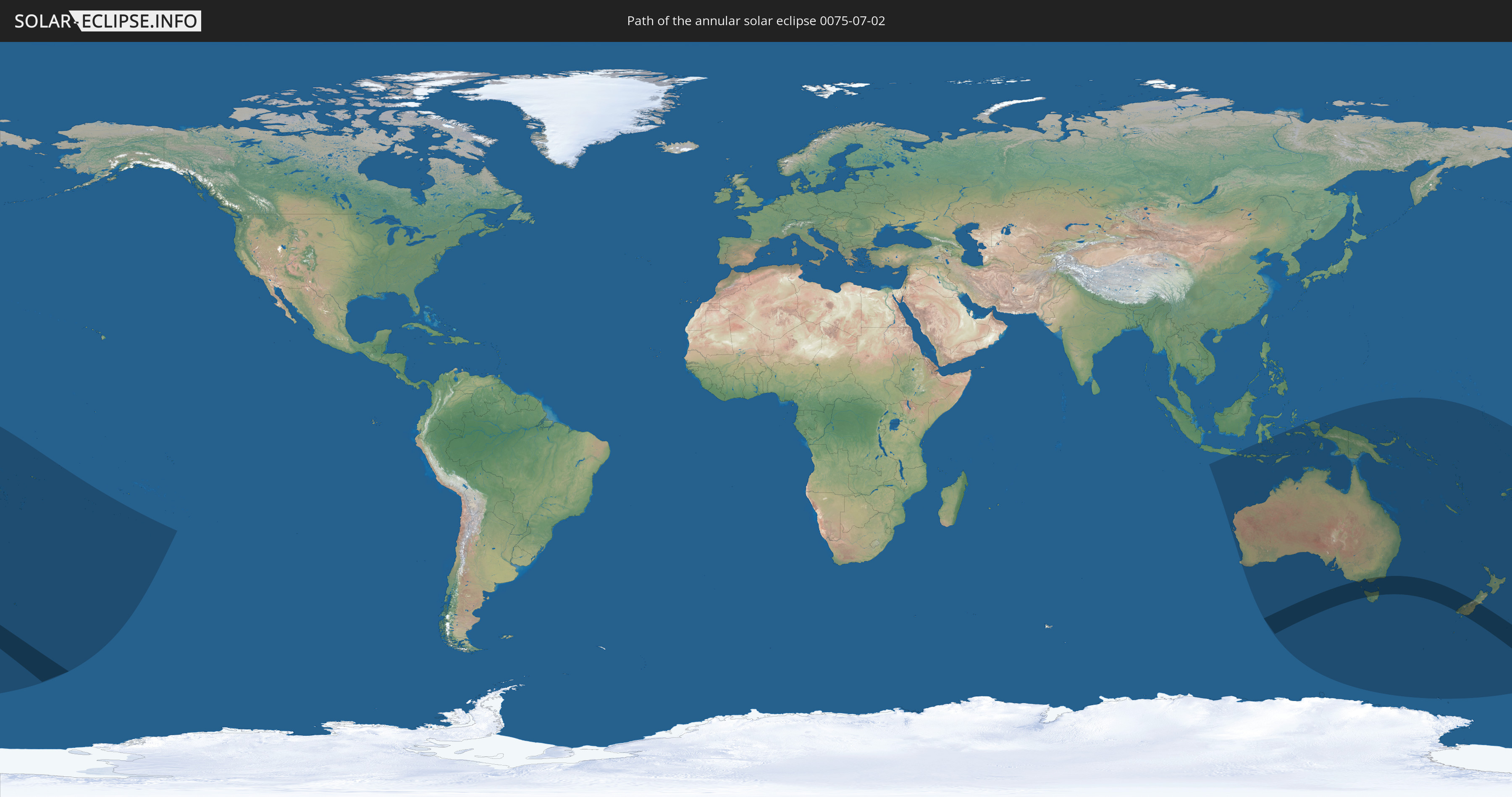
Die Sonnenfinsternis am 07/02/0075 kann man in 23 Ländern als partielle Sonnenfinsternis beobachten.
Der Finsternispfad verläuft durch 2 Länder. Nur in diesen Ländern ist sie als annular Sonnenfinsternis zu sehen.
In den folgenden Ländern ist die Sonnenfinsternis annular zu sehen
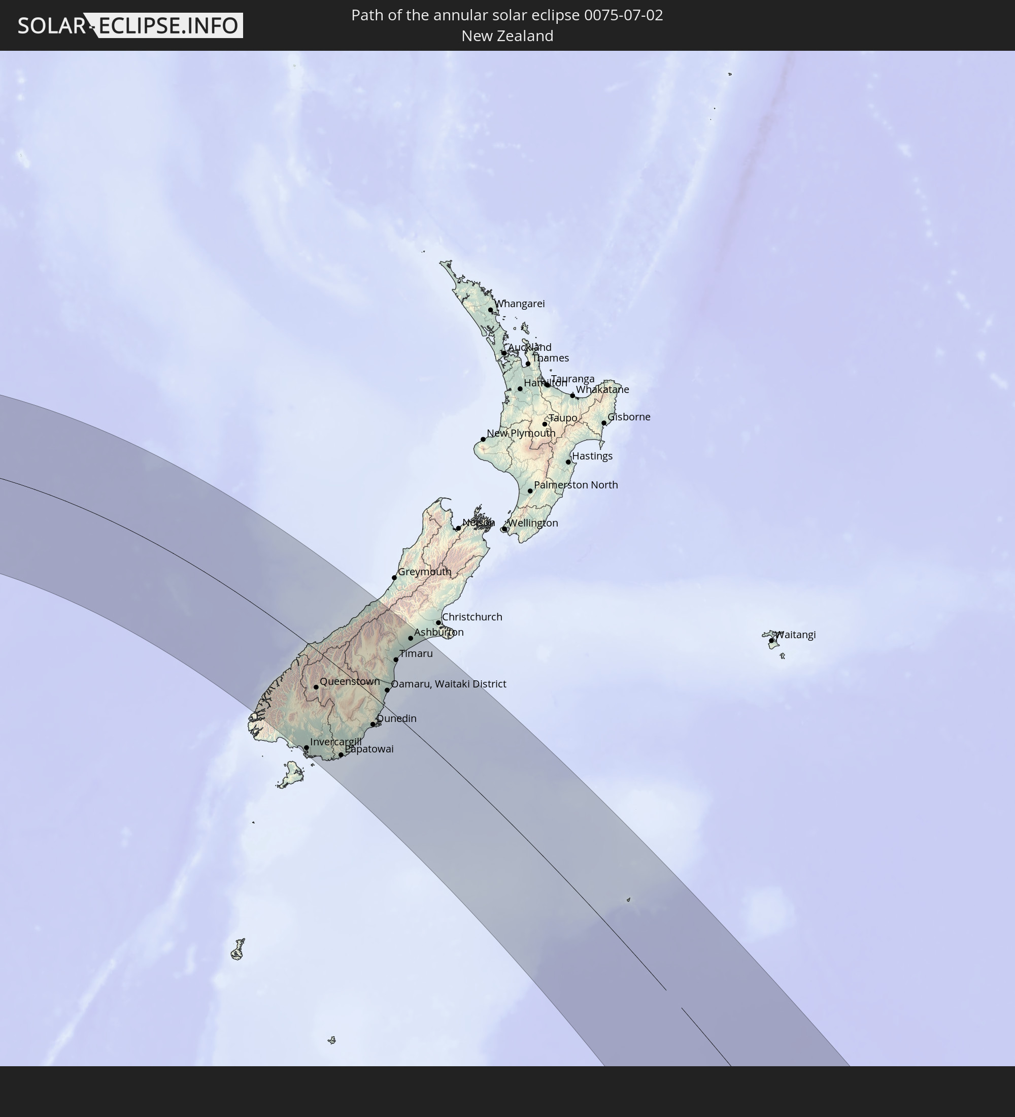 New Zealand
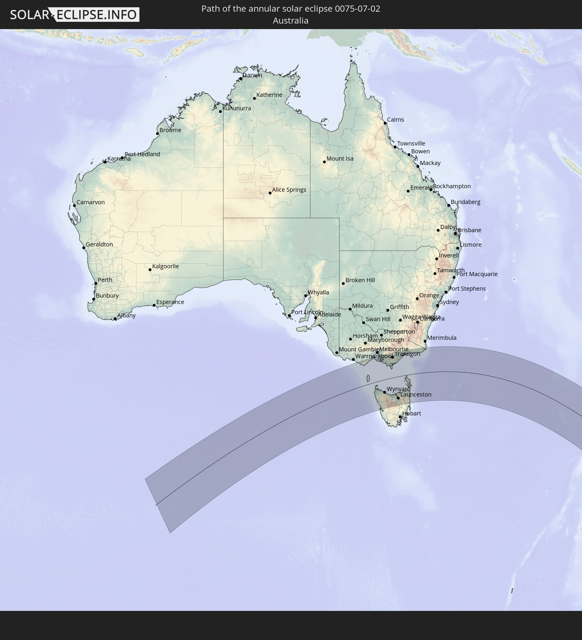 Australia
In den folgenden Ländern ist die Sonnenfinsternis partiell zu sehen


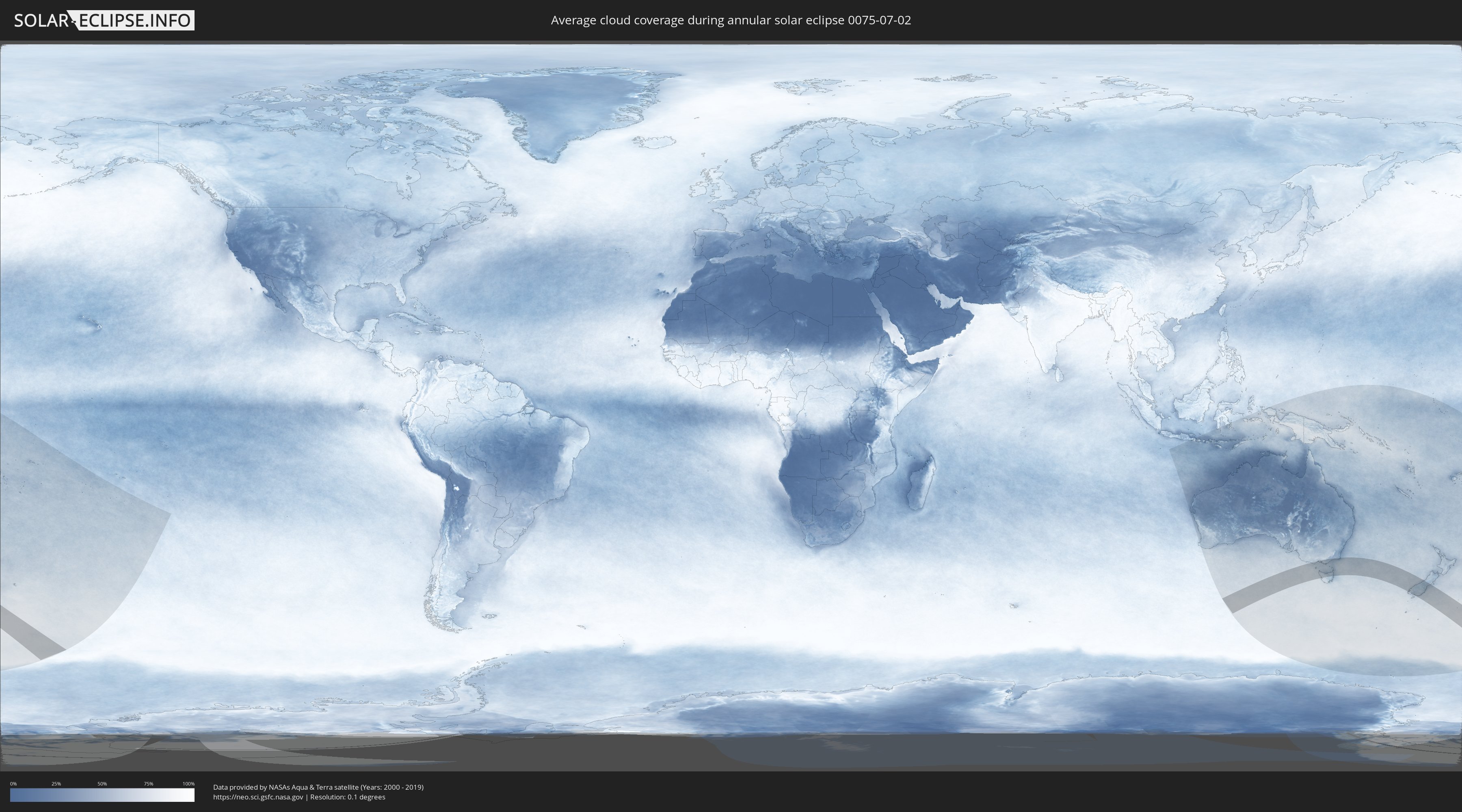
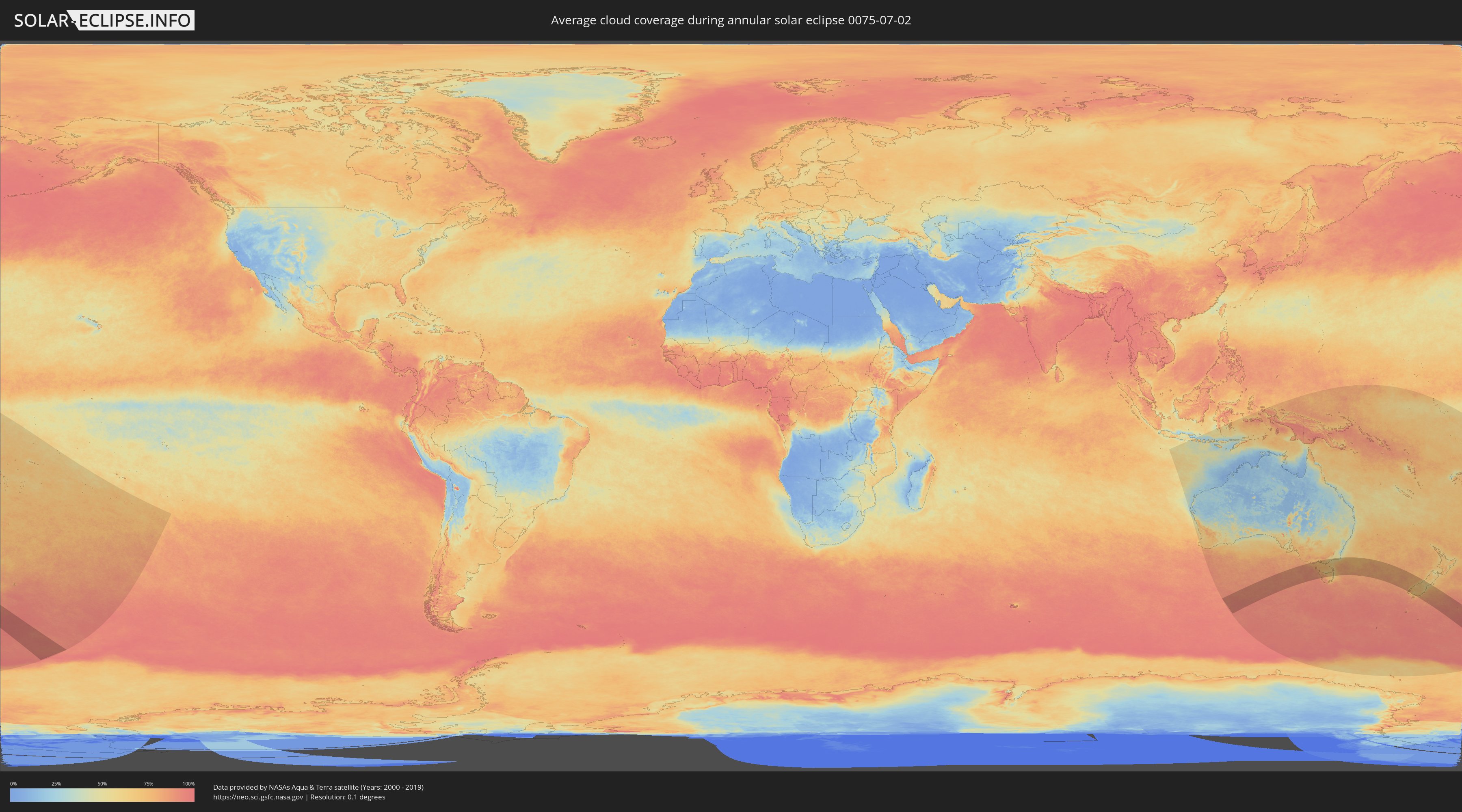
How will be the weather during the annular solar eclipse on 07/02/0075?
Where is the best place to see the annular solar eclipse of 07/02/0075?
The following maps show the average cloud coverage for the day of the annular solar eclipse.
With the help of these maps, it is possible to find the place along the eclipse path, which has the best
chance of a cloudless sky.
Nevertheless, you should consider local circumstances and inform about the weather of your chosen
observation site.
The data is provided by NASAs satellites
AQUA and TERRA.
The cloud maps are averaged over a period of 19 years (2000 - 2019).
Detailed country maps
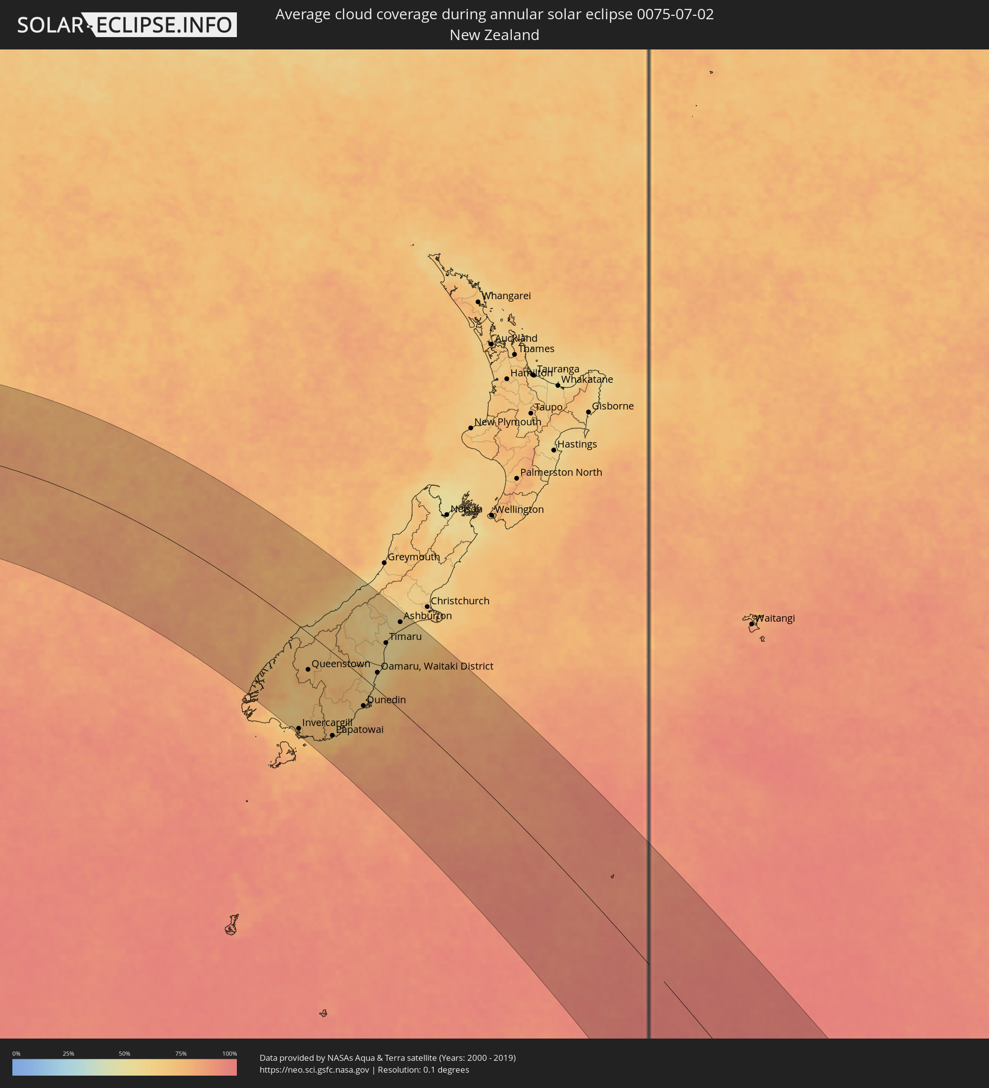 New Zealand
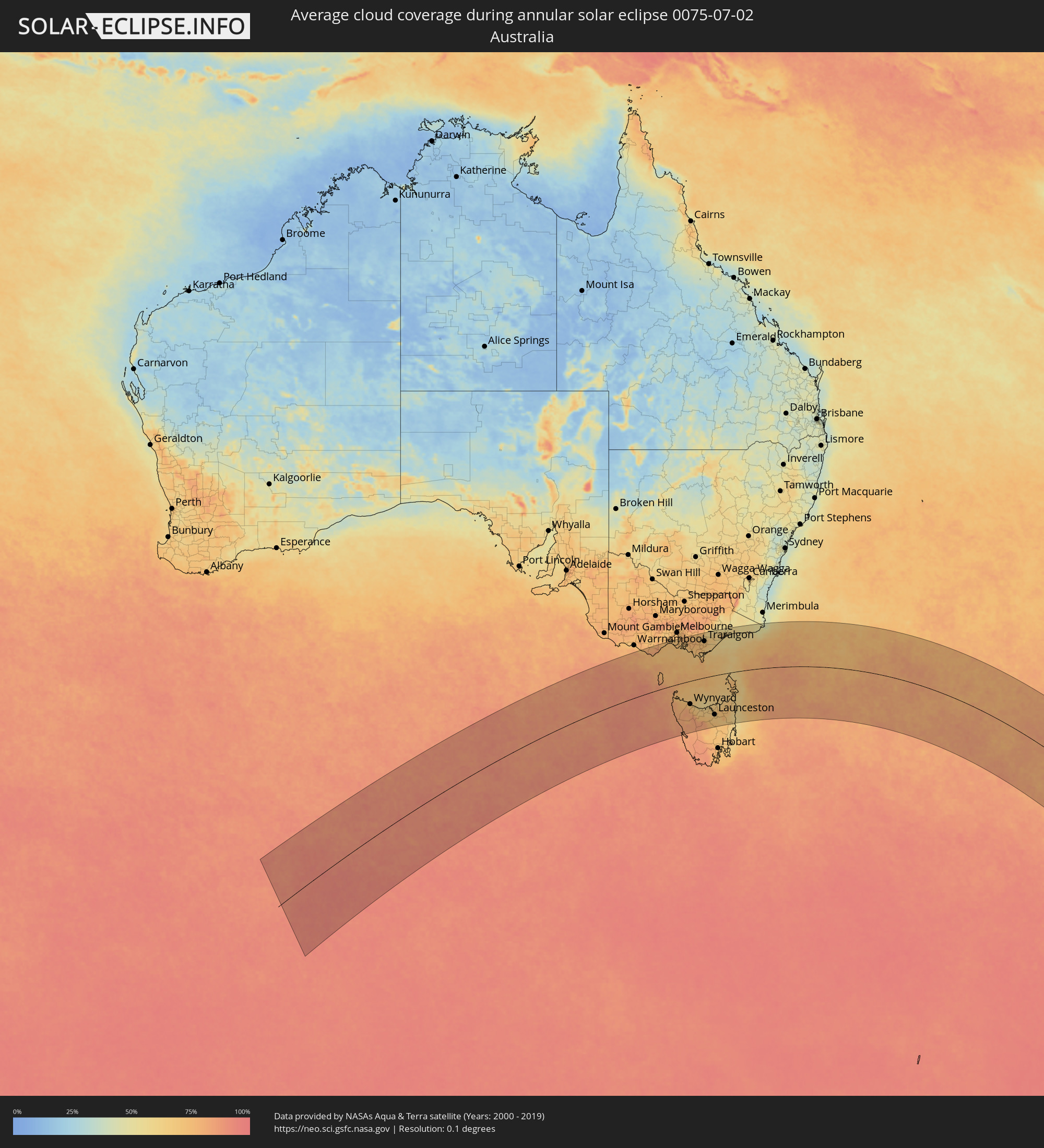 Australia
Cities inside the path of the eclipse
The following table shows all locations with a population of more than 5,000 inside the eclipse path. Cities which have more than 100,000 inhabitants are marked bold. A click at the locations opens a detailed map.
| City | Type | Eclipse duration | Local time of max. eclipse | Distance to central line | Ø Cloud coverage |
 Rye, Victoria
|
annular | - | 10:09:01 UTC+10:00 | 193 km | 73% |
|
Rosebud, Victoria
|
annular | - | 10:09:12 UTC+10:00 | 192 km | 73% |
|
Dromana, Victoria
|
annular | - | 10:09:18 UTC+10:00 | 193 km | 72% |
|
Mount Martha, Victoria
|
annular | - | 10:09:19 UTC+10:00 | 199 km | 72% |
|
Mornington, Victoria
|
annular | - | 10:09:19 UTC+10:00 | 204 km | 72% |
|
Mount Eliza, Victoria
|
annular | - | 10:09:22 UTC+10:00 | 207 km | 72% |
|
Bonbeach, Victoria
|
annular | - | 10:09:19 UTC+10:00 | 219 km | 74% |
|
Frankston, Victoria
|
annular | - | 10:09:24 UTC+10:00 | 210 km | 74% |
|
Seaford, Victoria
|
annular | - | 10:09:22 UTC+10:00 | 215 km | 74% |
|
Frankston East, Victoria
|
annular | - | 10:09:25 UTC+10:00 | 211 km | 74% |
|
Frankston South, Victoria
|
annular | - | 10:09:28 UTC+10:00 | 208 km | 72% |
|
Patterson Lakes, Victoria
|
annular | - | 10:09:21 UTC+10:00 | 218 km | 74% |
|
Frankston North, Victoria
|
annular | - | 10:09:26 UTC+10:00 | 212 km | 74% |
|
Langwarrin, Victoria
|
annular | - | 10:09:31 UTC+10:00 | 207 km | 70% |
|
Somerville, Victoria
|
annular | - | 10:09:35 UTC+10:00 | 201 km | 70% |
|
Carrum Downs, Victoria
|
annular | - | 10:09:27 UTC+10:00 | 214 km | 74% |
|
Hastings, Victoria
|
annular | - | 10:09:43 UTC+10:00 | 192 km | 68% |
|
Skye, Victoria
|
annular | - | 10:09:33 UTC+10:00 | 213 km | 74% |
|
Phillip Island, Victoria
|
annular | - | 10:10:02 UTC+10:00 | 171 km | 69% |
|
Lynbrook, Victoria
|
annular | - | 10:09:35 UTC+10:00 | 217 km | 74% |
|
Cranbourne West, Victoria
|
annular | - | 10:09:39 UTC+10:00 | 212 km | 74% |
|
Cranbourne North, Victoria
|
annular | - | 10:09:40 UTC+10:00 | 214 km | 74% |
|
Cranbourne, Victoria
|
annular | - | 10:09:43 UTC+10:00 | 210 km | 74% |
|
Cranbourne, Victoria
|
annular | - | 10:09:42 UTC+10:00 | 212 km | 74% |
|
Narre Warren South, Victoria
|
annular | - | 10:09:39 UTC+10:00 | 218 km | 78% |
|
Cranbourne East, Victoria
|
annular | - | 10:09:45 UTC+10:00 | 210 km | 74% |
|
Narre Warren, Victoria
|
annular | - | 10:09:39 UTC+10:00 | 219 km | 78% |
|
Berwick, Victoria
|
annular | - | 10:09:45 UTC+10:00 | 217 km | 74% |
|
Pakenham South, Victoria
|
annular | - | 10:10:14 UTC+10:00 | 203 km | 75% |
|
North Wonthaggi, Victoria
|
annular | - | 10:10:58 UTC+10:00 | 151 km | 69% |
|
Wynyard, Tasmania
|
annular | - | 10:14:05 UTC+10:00 | 110 km | 74% |
|
Burnie, Tasmania
|
annular | - | 10:14:32 UTC+10:00 | 121 km | 69% |
|
Warragul, Victoria
|
annular | - | 10:11:10 UTC+10:00 | 192 km | 77% |
|
Ulverstone, Tasmania
|
annular | - | 10:15:15 UTC+10:00 | 138 km | 66% |
|
Moe, Victoria
|
annular | - | 10:11:54 UTC+10:00 | 184 km | 72% |
|
Devonport, Tasmania
|
annular | - | 10:15:37 UTC+10:00 | 143 km | 67% |
|
Morwell, Victoria
|
annular | - | 10:12:16 UTC+10:00 | 176 km | 72% |
|
Traralgon, Victoria
|
annular | - | 10:12:33 UTC+10:00 | 177 km | 71% |
|
Sale, Victoria
|
annular | - | 10:13:37 UTC+10:00 | 178 km | 66% |
|
Newnham, Tasmania
|
annular | - | 10:17:32 UTC+10:00 | 182 km | 66% |
|
Launceston, Tasmania
|
annular | - | 10:17:35 UTC+10:00 | 186 km | 66% |
|
Bairnsdale, Victoria
|
annular | - | 10:14:31 UTC+10:00 | 201 km | 64% |
|
Lakes Entrance, Victoria
|
annular | - | 10:15:26 UTC+10:00 | 190 km | 55% |
 Invercargill, Southland
|
annular | - | 12:38:26 UTC+11:30 | 208 km | 70% |
|
Queenstown, Otago
|
annular | - | 12:39:01 UTC+11:30 | 76 km | 69% |
|
Gore, Southland
|
annular | - | 12:39:39 UTC+11:30 | 153 km | 70% |
|
Papatowai, Otago
|
annular | - | 12:40:44 UTC+11:30 | 165 km | 70% |
|
Dunedin, Otago
|
annular | - | 12:42:53 UTC+11:30 | 55 km | 65% |
|
Oamaru, Waitaki District, Otago
|
annular | - | 12:43:52 UTC+11:30 | 34 km | 55% |
|
Timaru, Canterbury
|
annular | - | 12:44:30 UTC+11:30 | 109 km | 55% |
|
Ashburton, Canterbury
|
annular | - | 12:45:31 UTC+11:30 | 176 km | 61% |