Total solar eclipse of 01/18/0120
| Day of week: | Thursday |
| Maximum duration of eclipse: | 03m16s |
| Maximum width of eclipse path: | 185 km |
| Saros cycle: | 62 |
| Coverage: | 100% |
| Magnitude: | 1.0359 |
| Gamma: | 0.7574 |
Wo kann man die Sonnenfinsternis vom 01/18/0120 sehen?
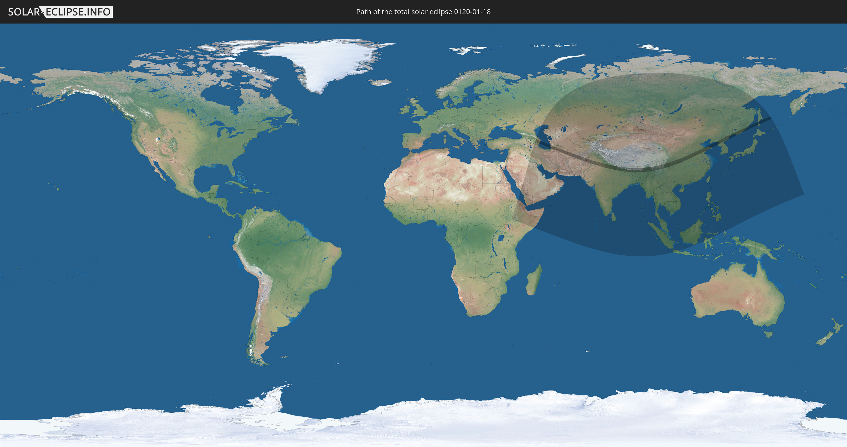
Die Sonnenfinsternis am 01/18/0120 kann man in 51 Ländern als partielle Sonnenfinsternis beobachten.
Der Finsternispfad verläuft durch 12 Länder. Nur in diesen Ländern ist sie als total Sonnenfinsternis zu sehen.
In den folgenden Ländern ist die Sonnenfinsternis total zu sehen
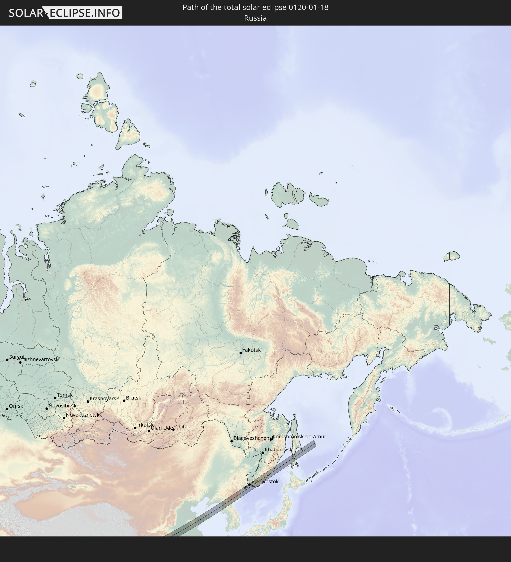 Russia
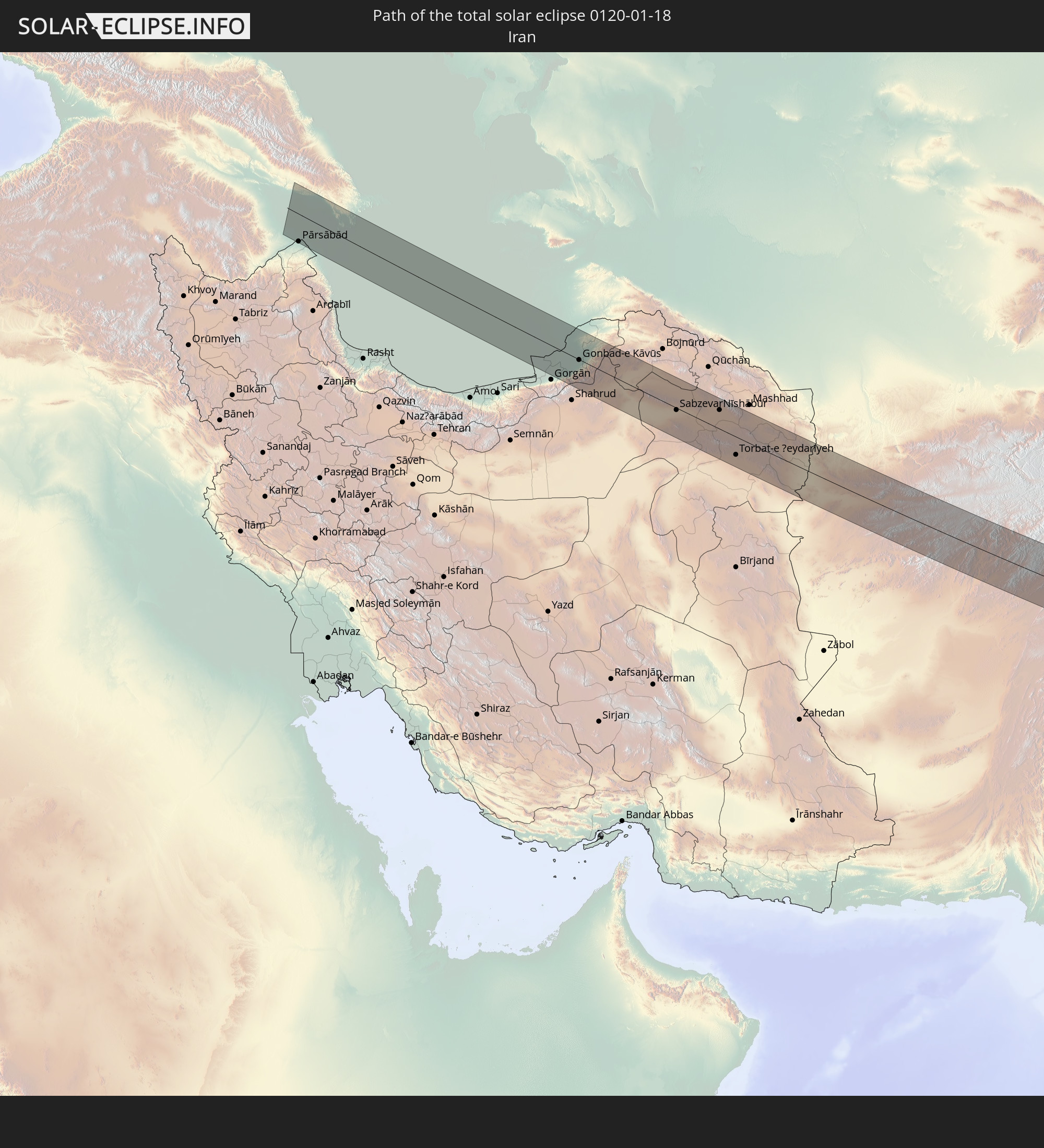 Iran
Iran
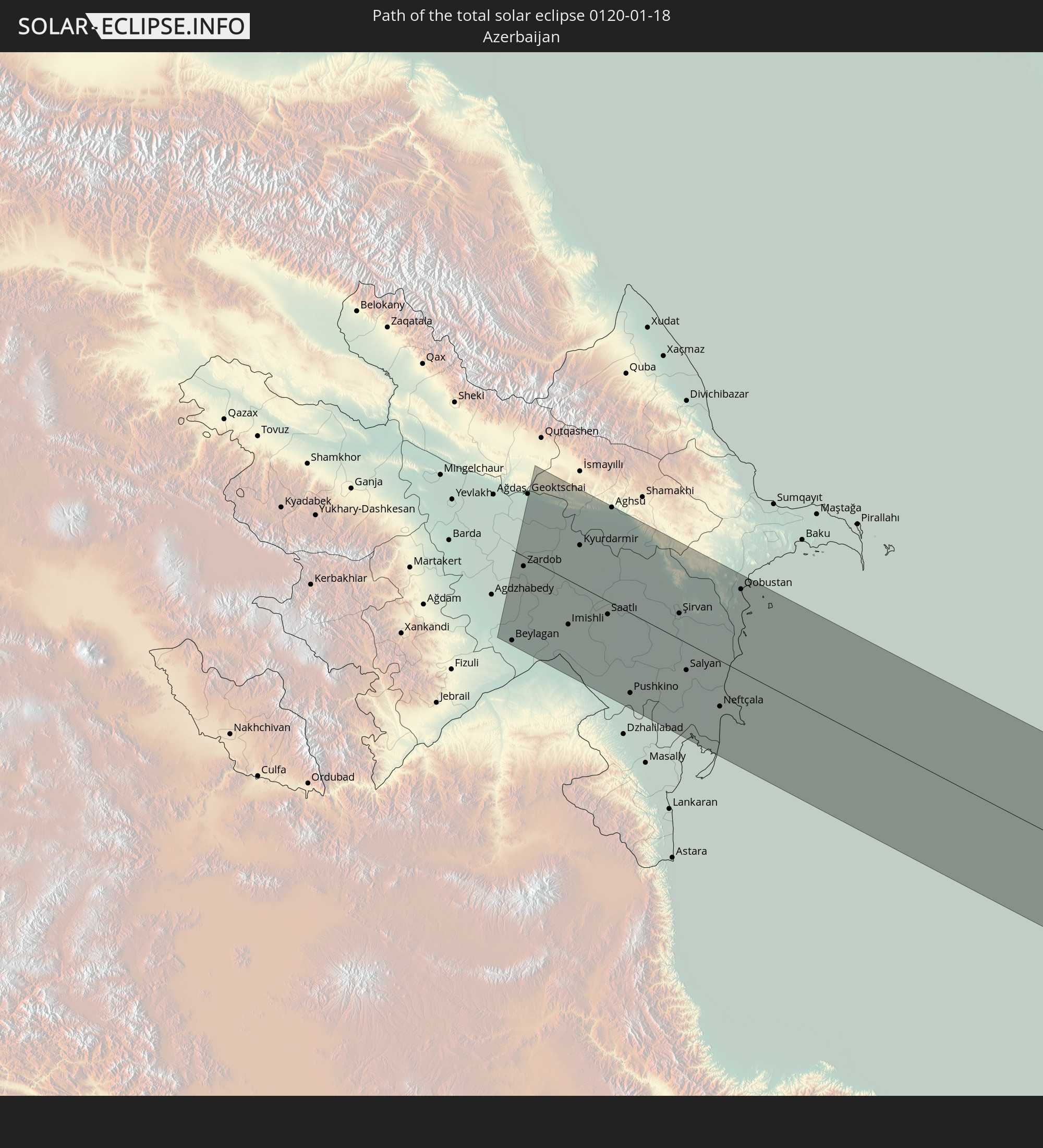 Azerbaijan
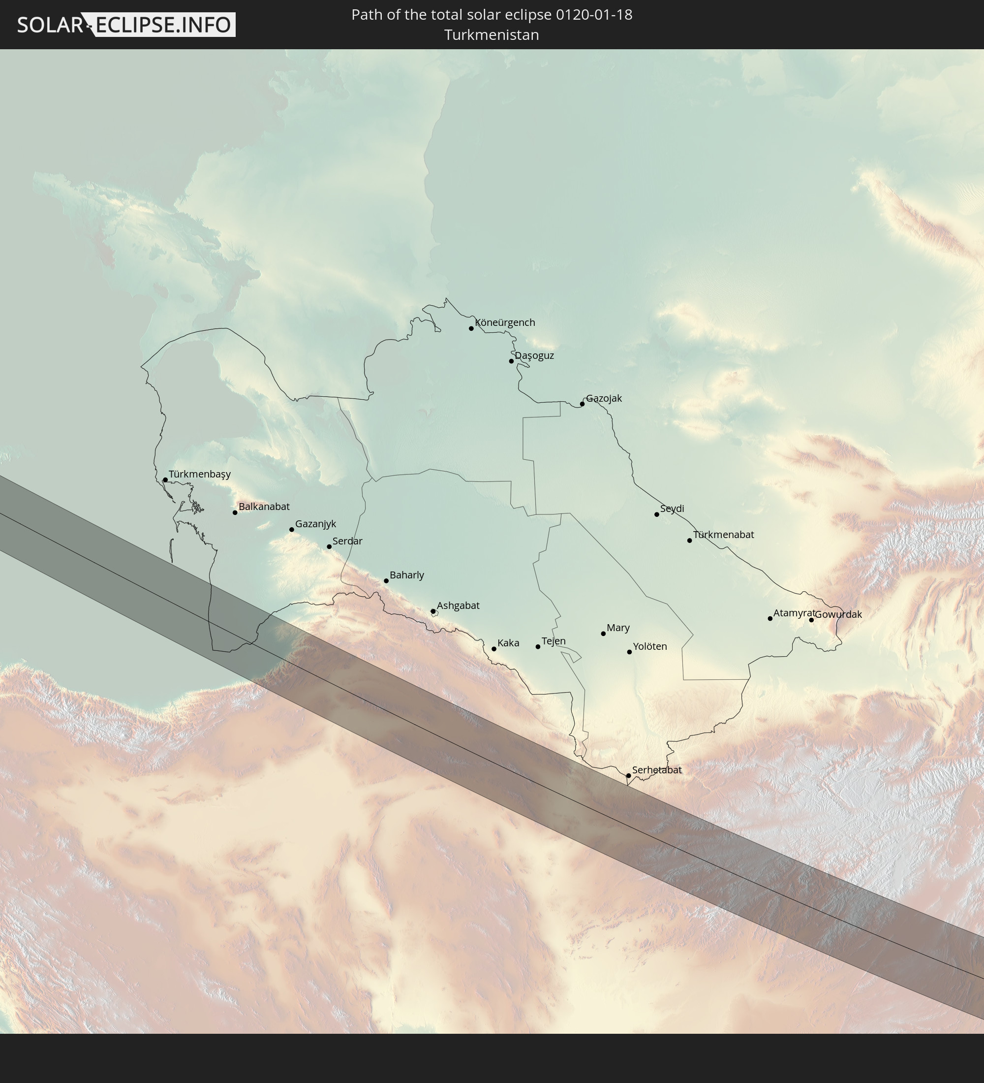 Turkmenistan
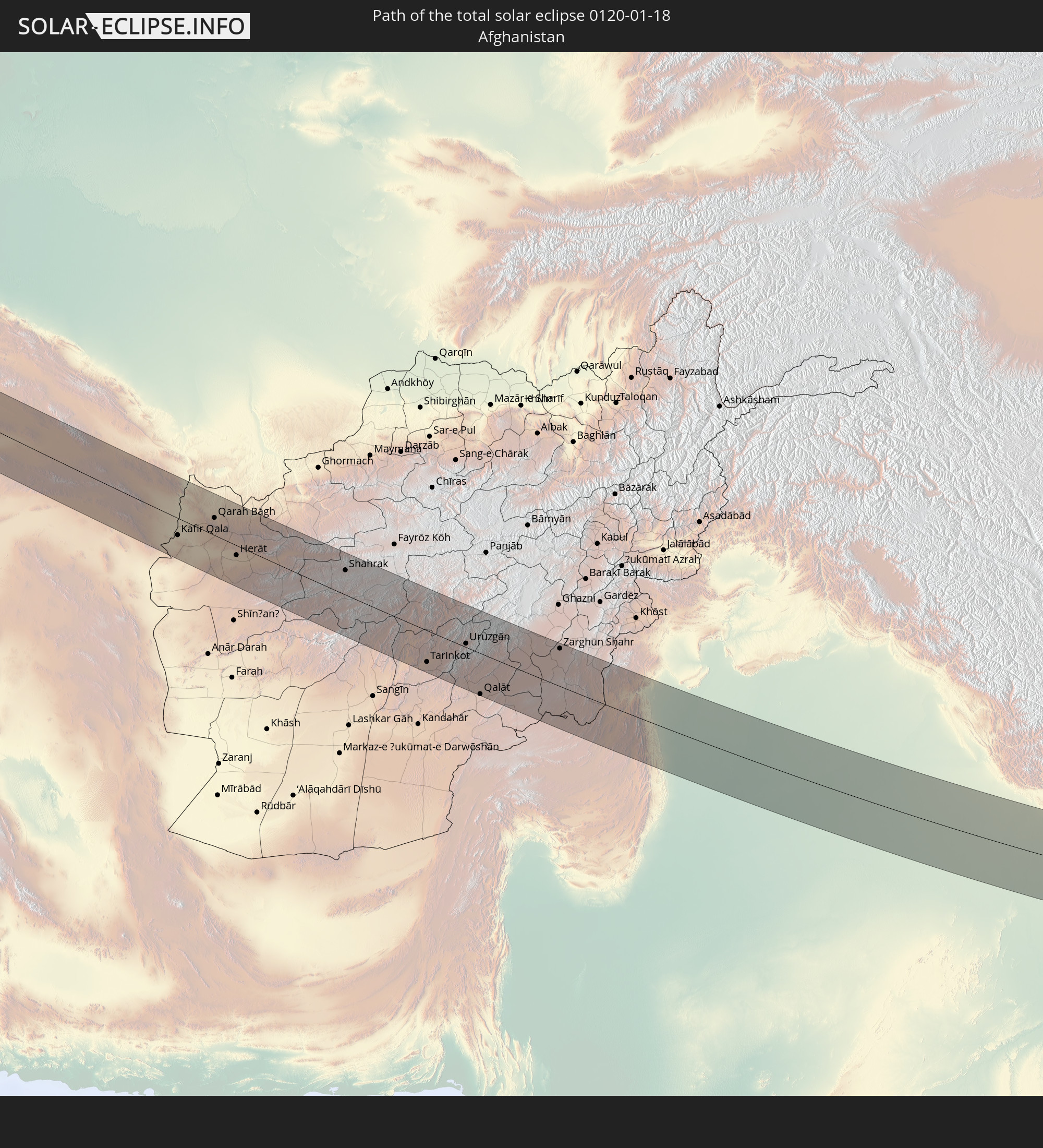 Afghanistan
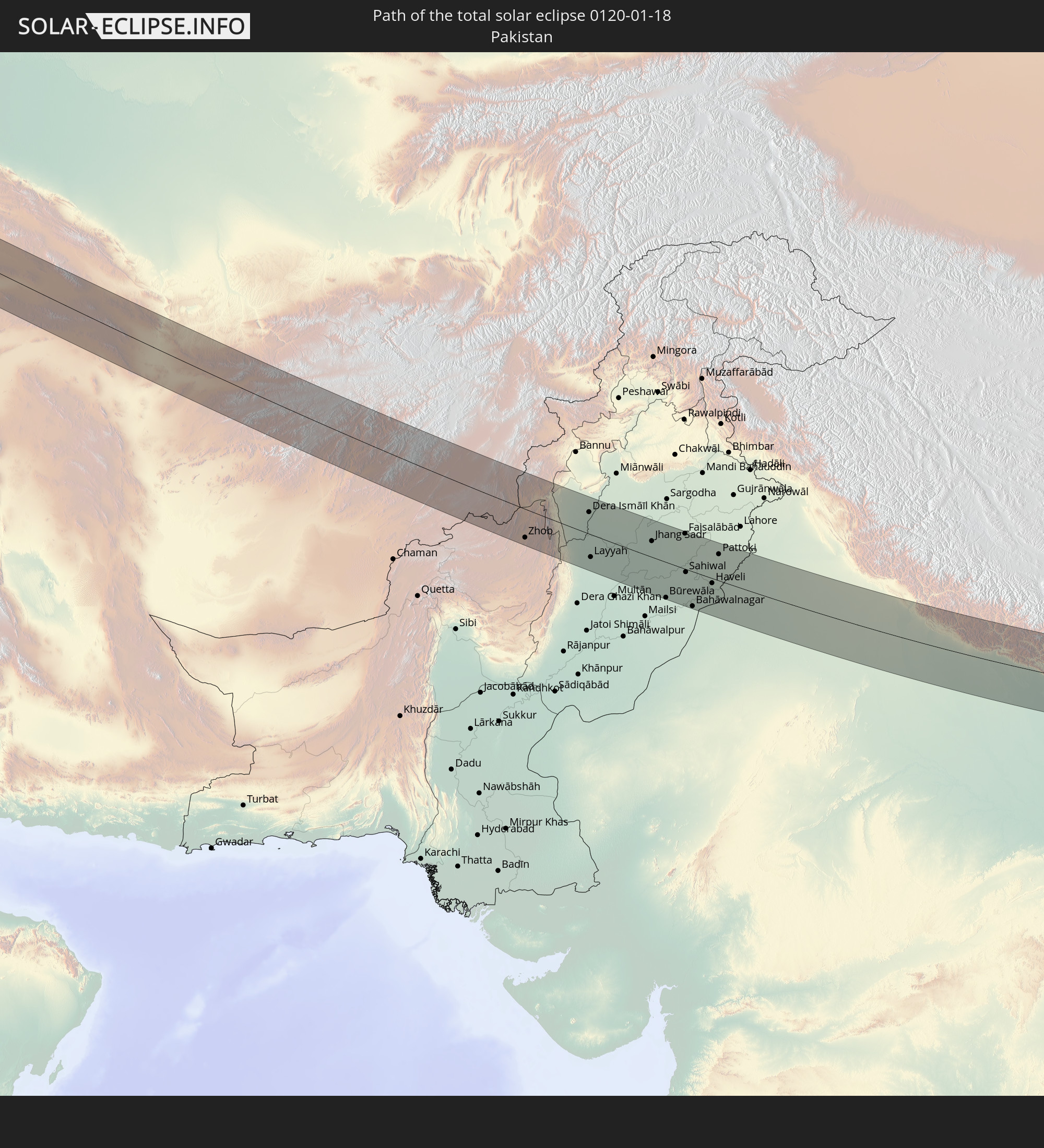 Pakistan
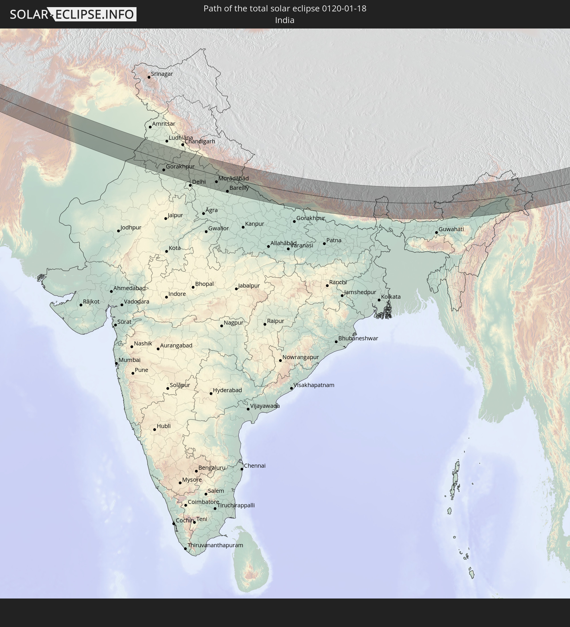 India
India
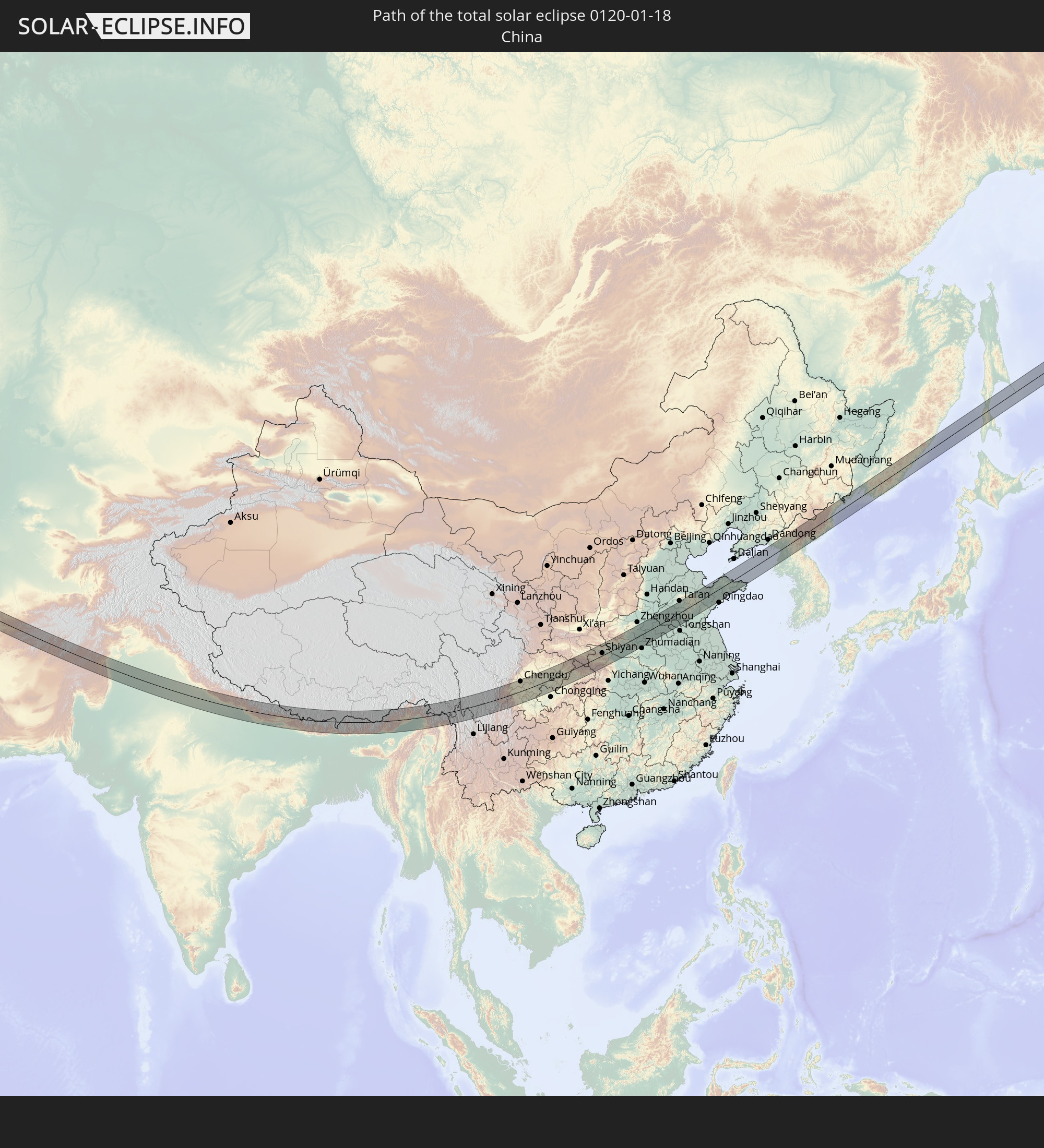 China
China
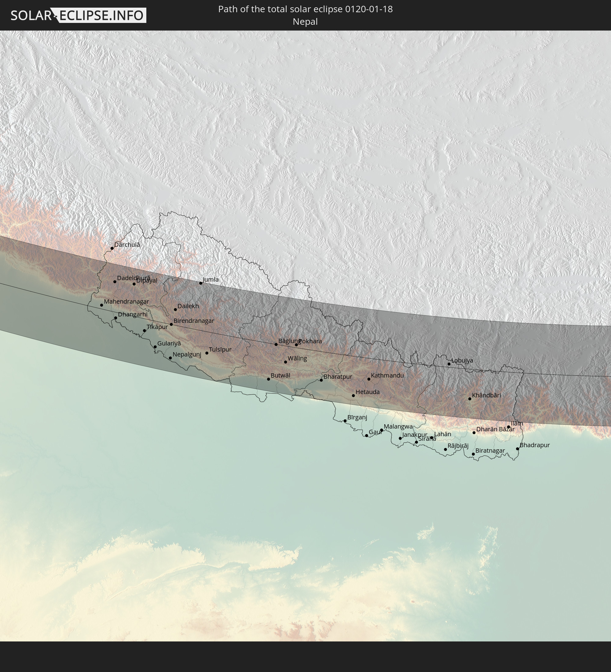 Nepal
Nepal
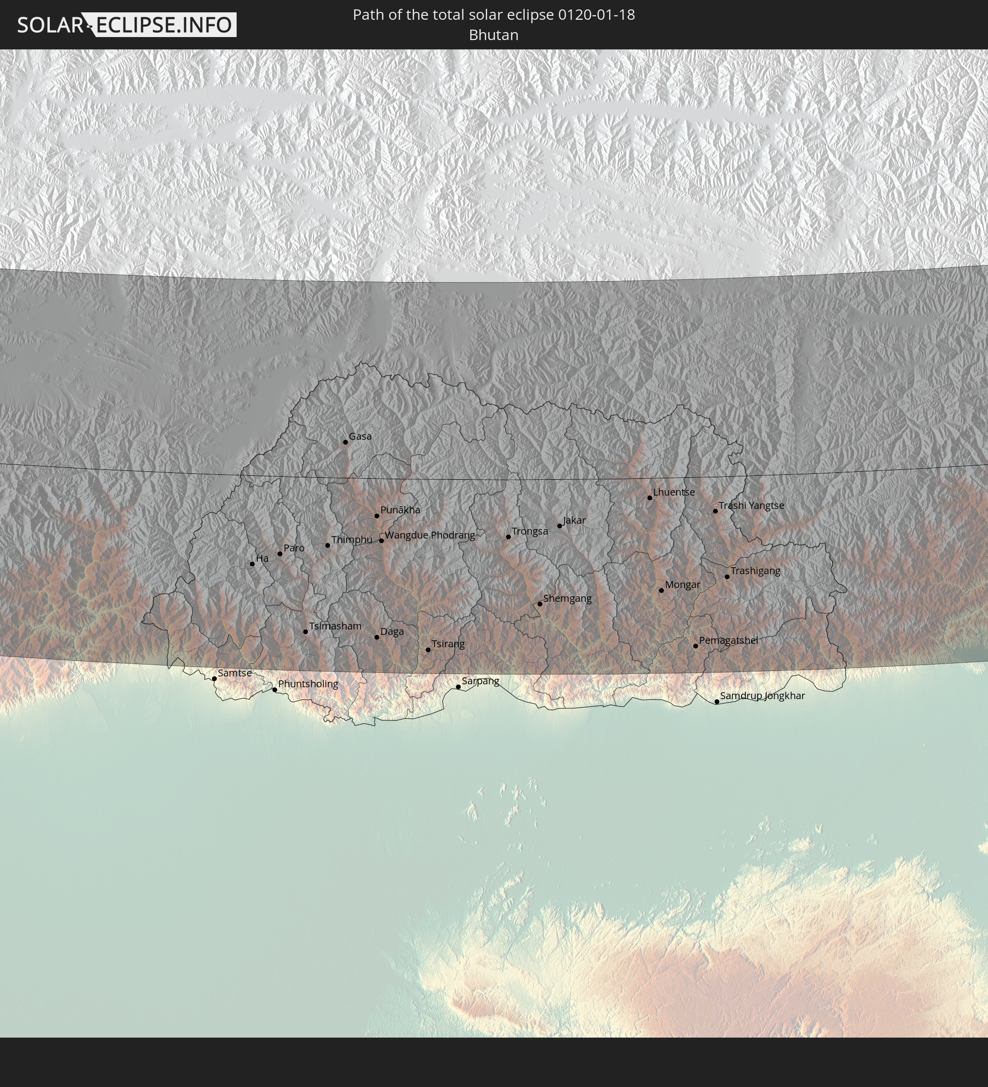 Bhutan
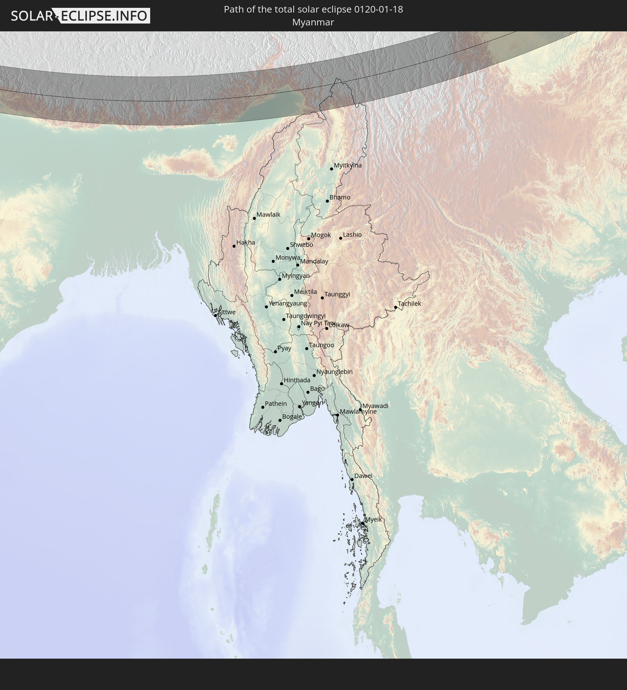 Myanmar
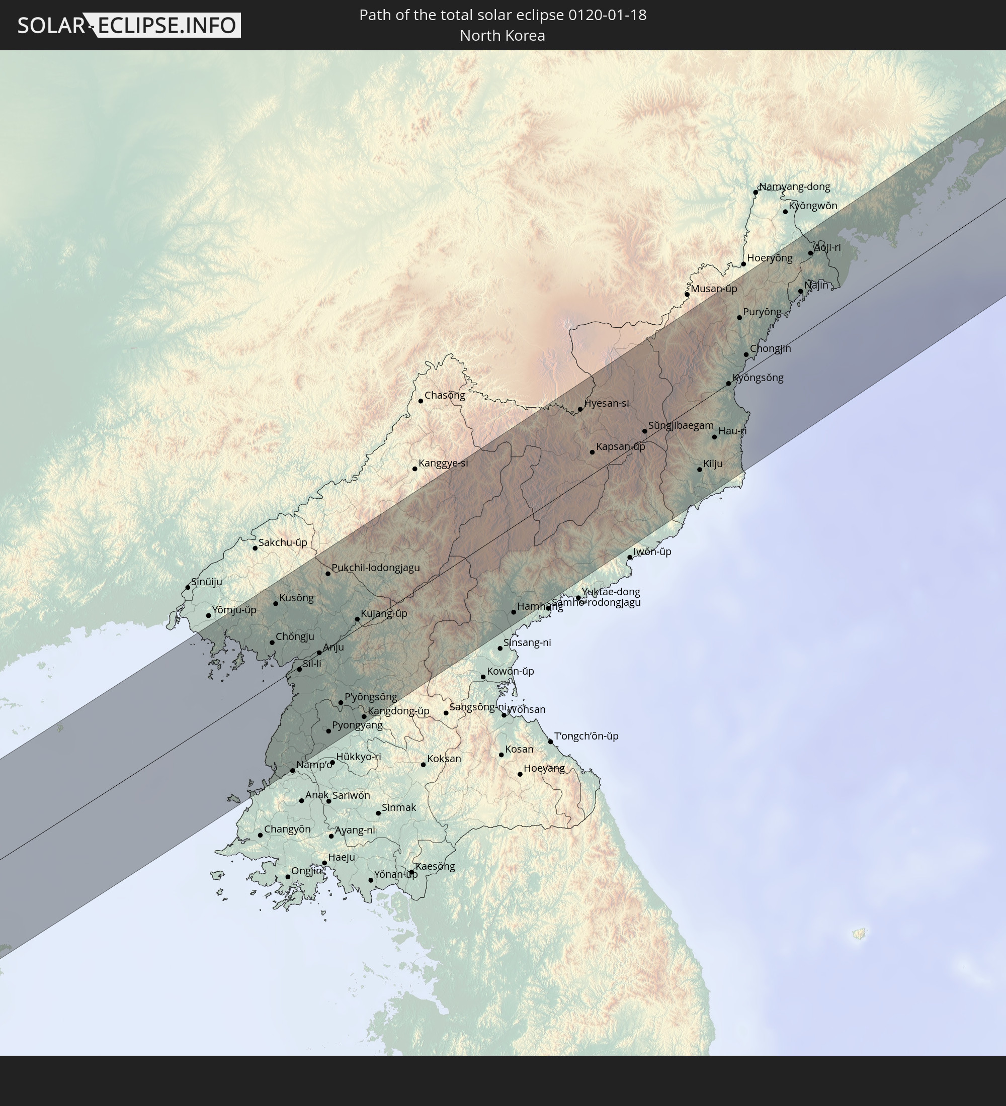 North Korea
In den folgenden Ländern ist die Sonnenfinsternis partiell zu sehen
 Russia
 Ethiopia
 Saudi Arabia
 Eritrea
 Iraq
Iraq
 Somalia
 Djibouti
 Yemen
Yemen
 Iran
Iran
 Azerbaijan
 Kazakhstan
 Kuwait
 Bahrain
 Qatar
Qatar
 United Arab Emirates
 Oman
Oman
 Turkmenistan
 Uzbekistan
 Afghanistan
 Pakistan
 Tajikistan
 India
India
 Kyrgyzstan
 British Indian Ocean Territory
 Maldives
 China
China
 Sri Lanka
 Nepal
Nepal
 Mongolia
 Bangladesh
 Bhutan
 Myanmar
 Indonesia
 Thailand
 Malaysia
 Laos
Laos
 Vietnam
 Cambodia
 Singapore
 Macau
Macau
 Hong Kong
 Brunei
 Taiwan
 Philippines
 Japan
Japan
 North Korea
 South Korea
 Palau
Palau
 Federated States of Micronesia
 Guam
Guam
 Northern Mariana Islands
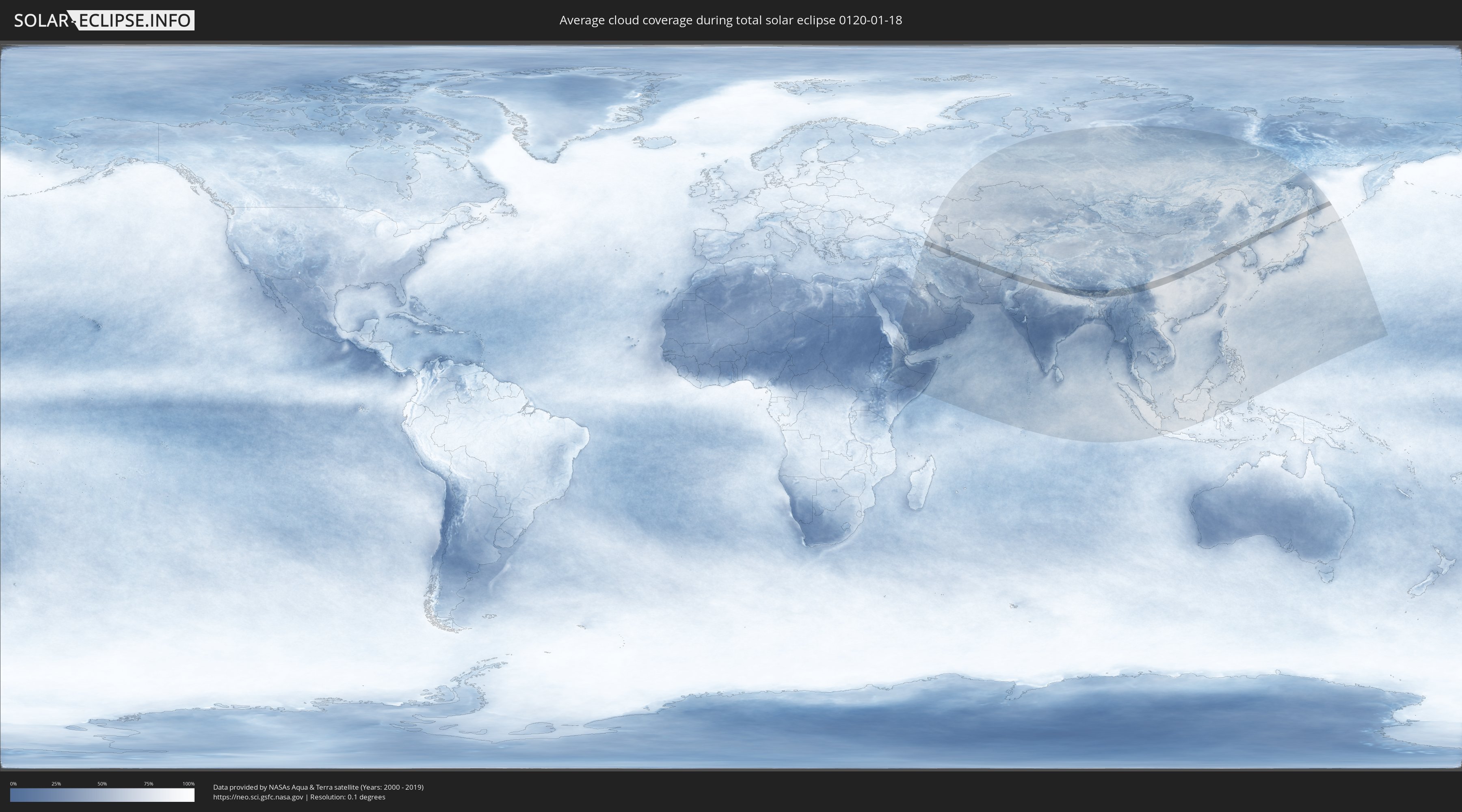
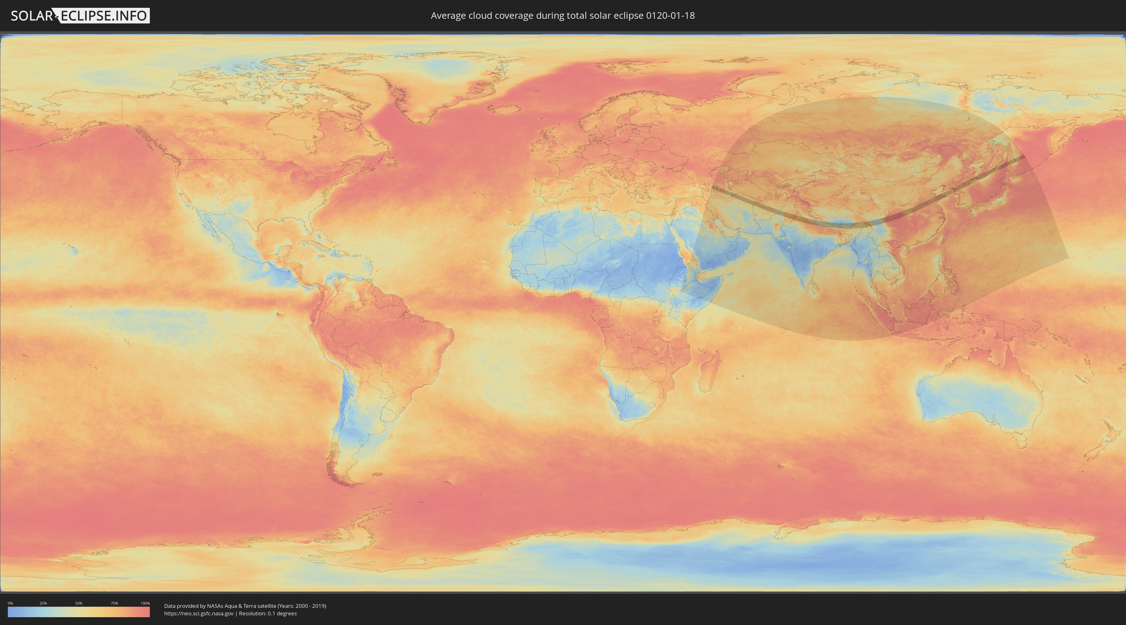
How will be the weather during the total solar eclipse on 01/18/0120?
Where is the best place to see the total solar eclipse of 01/18/0120?
The following maps show the average cloud coverage for the day of the total solar eclipse.
With the help of these maps, it is possible to find the place along the eclipse path, which has the best
chance of a cloudless sky.
Nevertheless, you should consider local circumstances and inform about the weather of your chosen
observation site.
The data is provided by NASAs satellites
AQUA and TERRA.
The cloud maps are averaged over a period of 19 years (2000 - 2019).
Detailed country maps
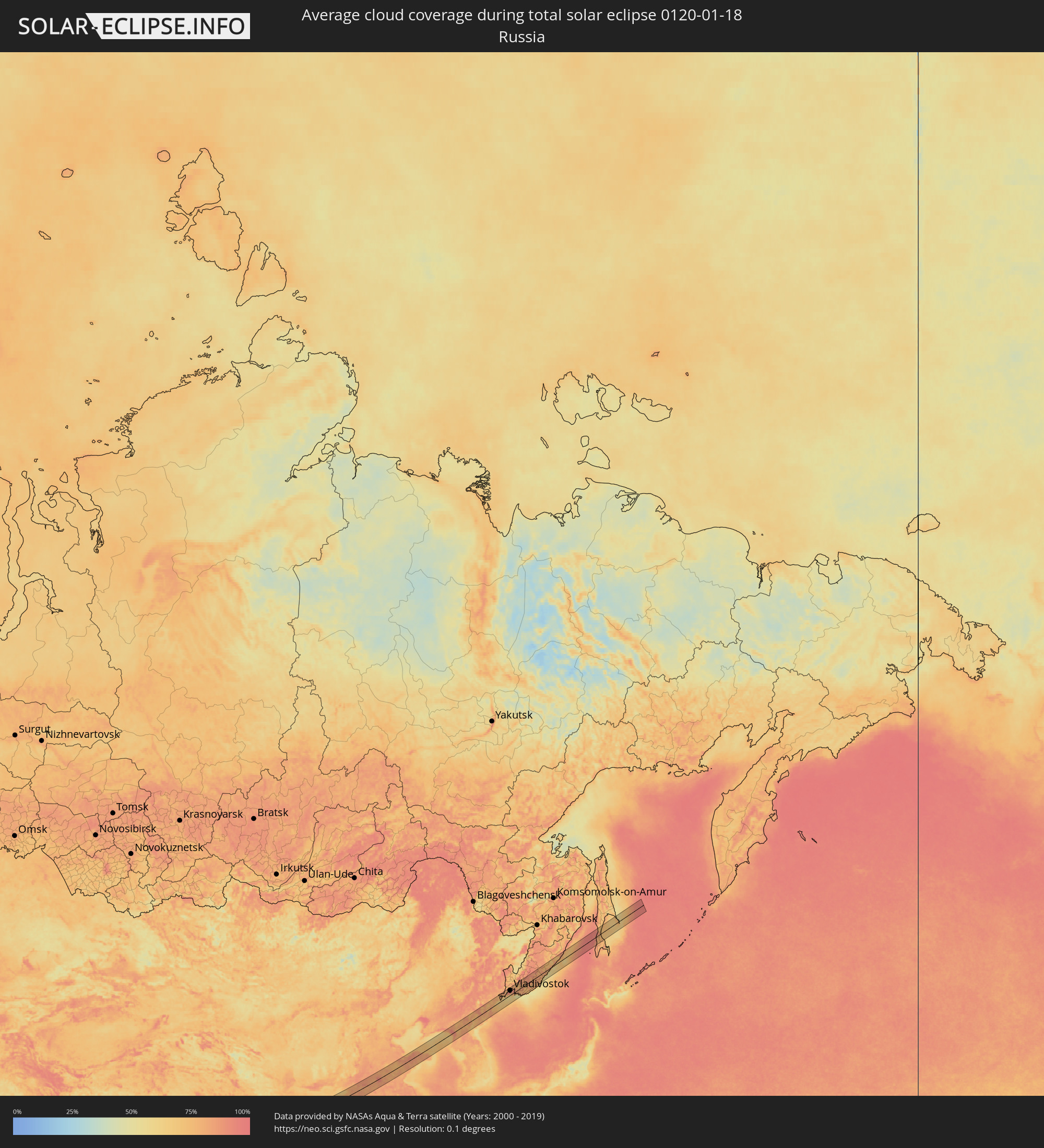 Russia
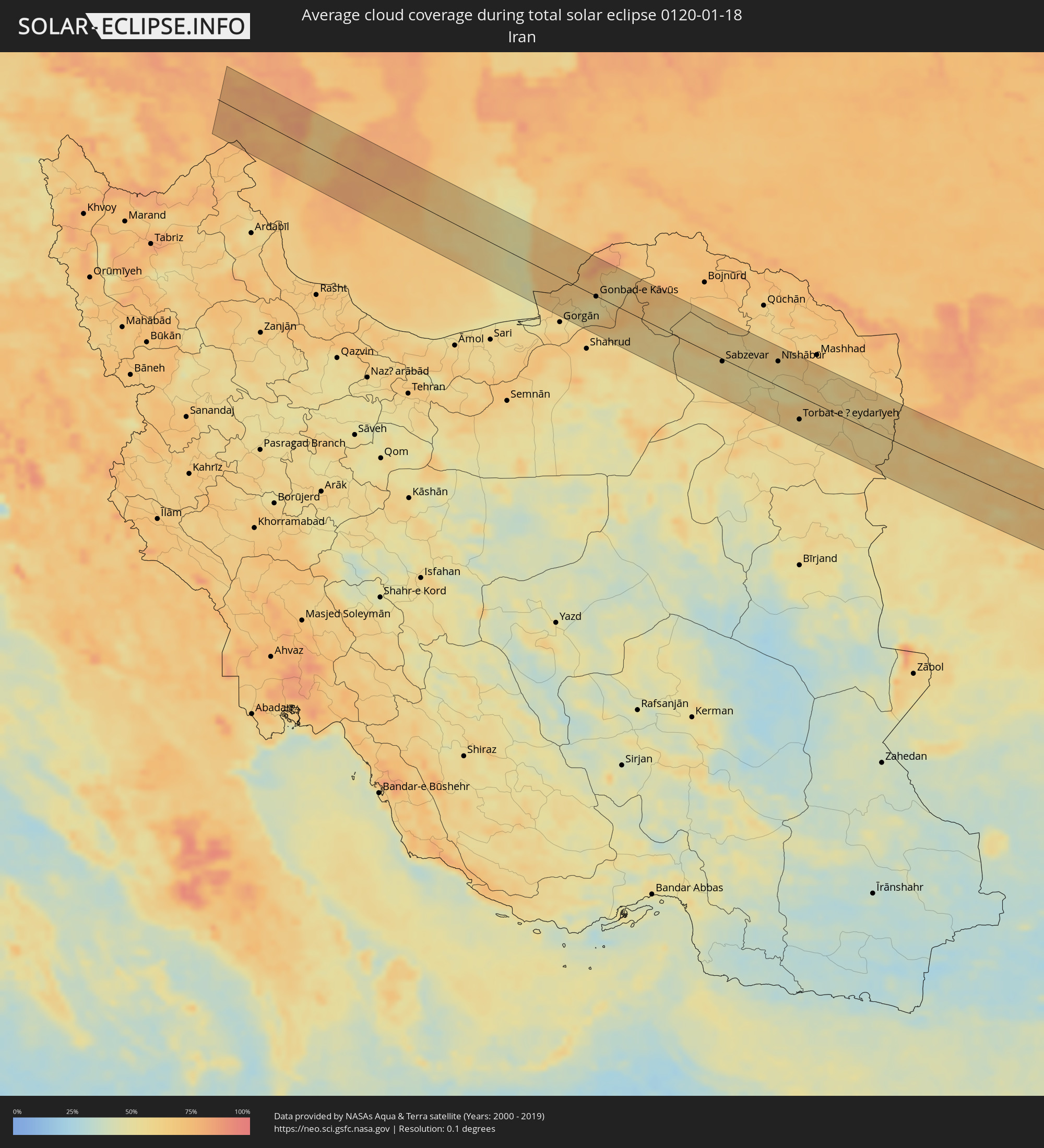 Iran
Iran
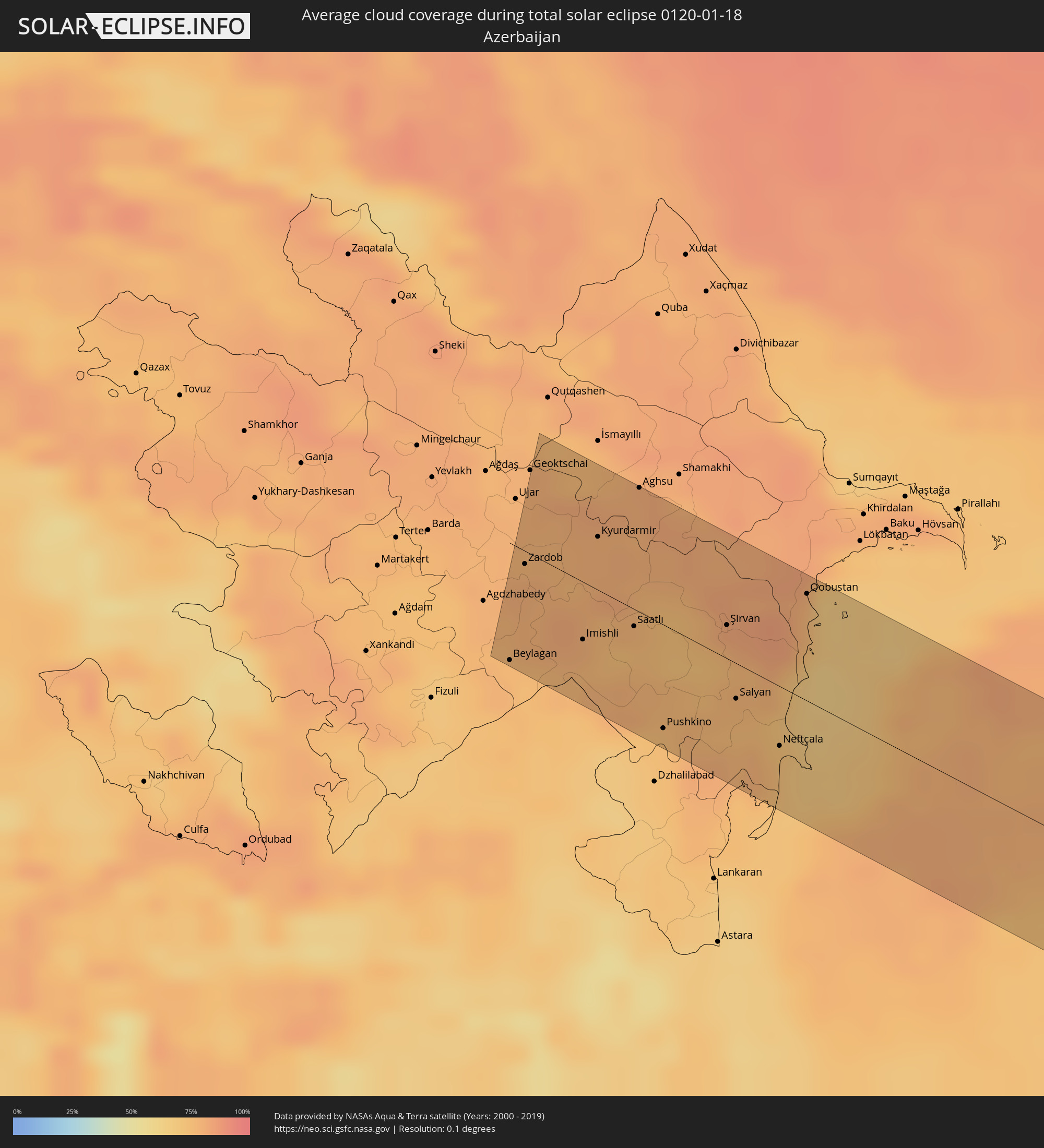 Azerbaijan
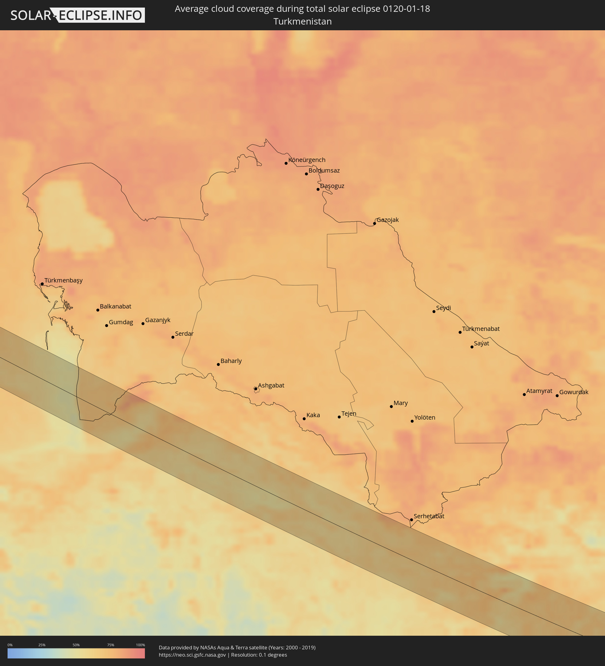 Turkmenistan
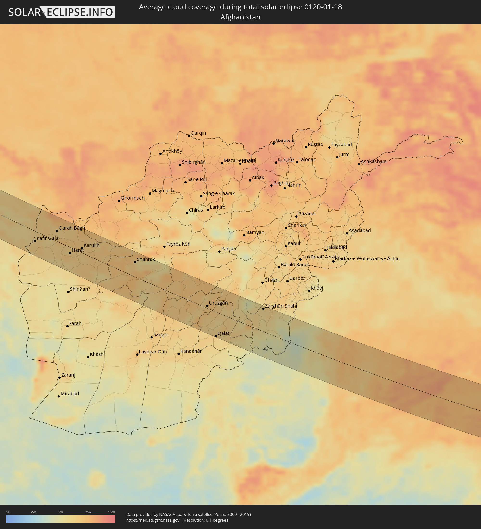 Afghanistan
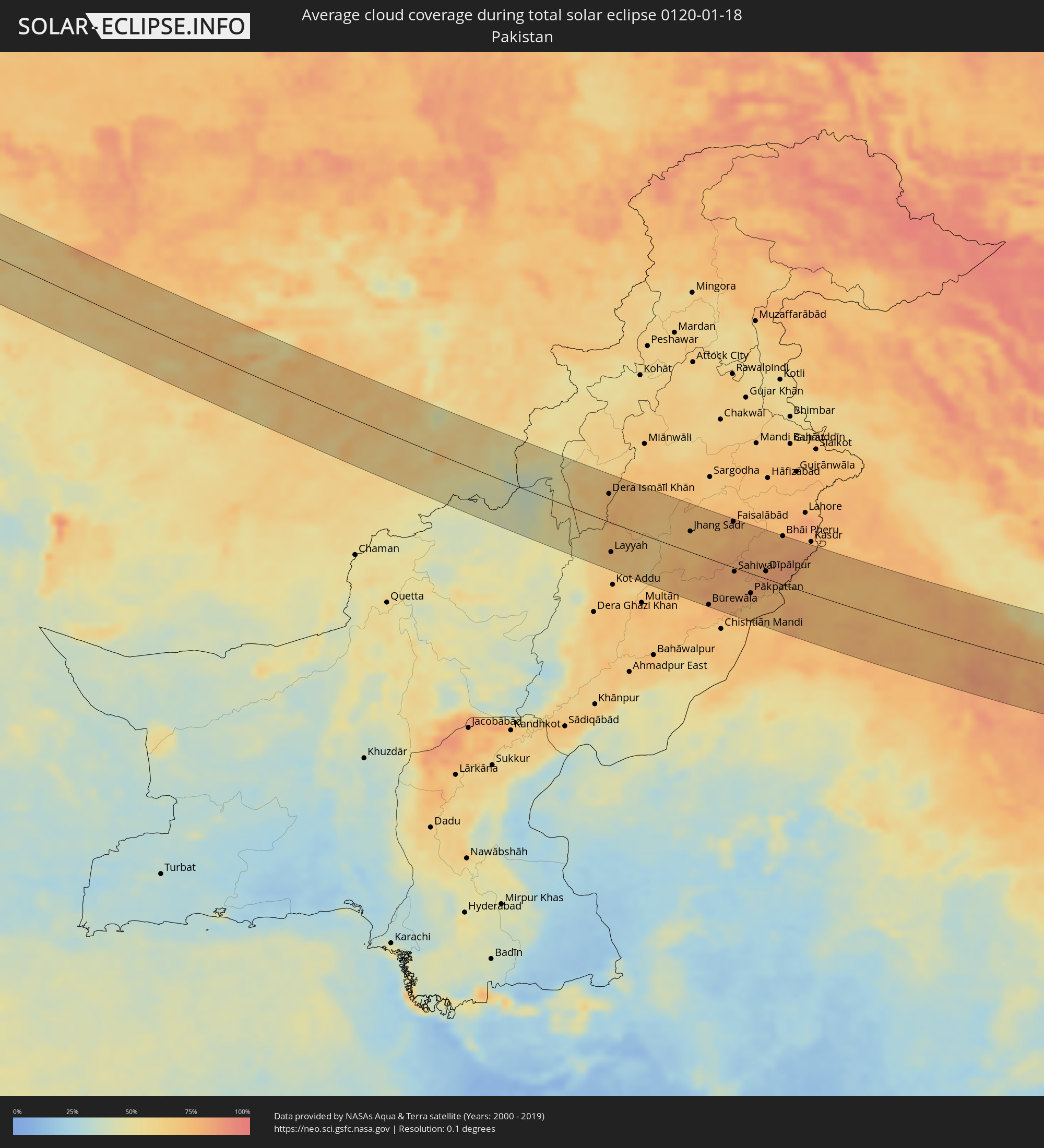 Pakistan
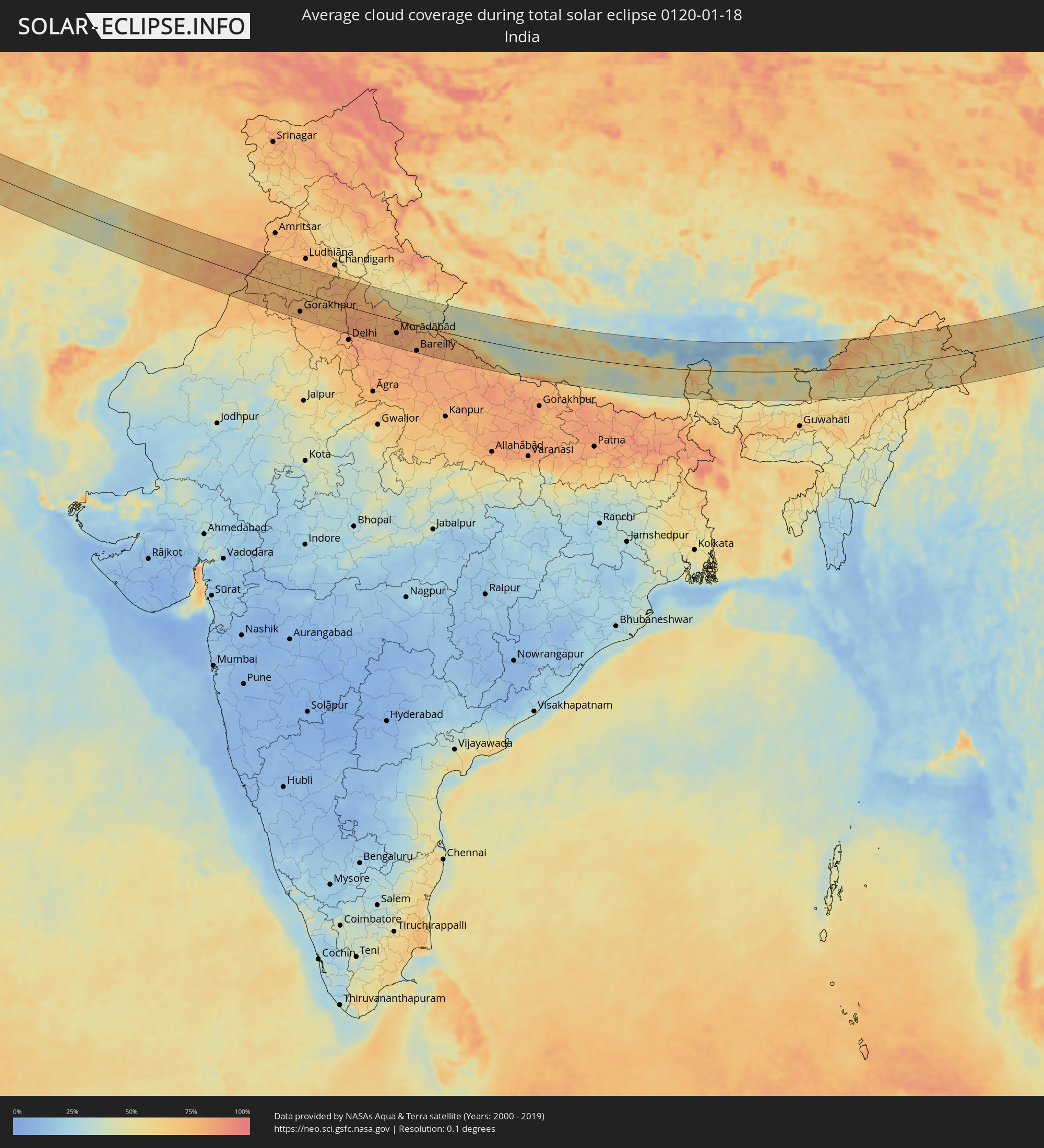 India
India
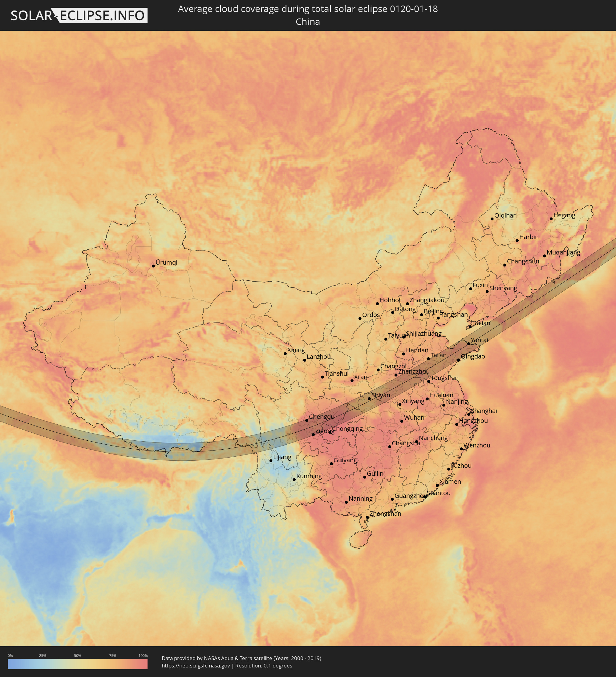 China
China
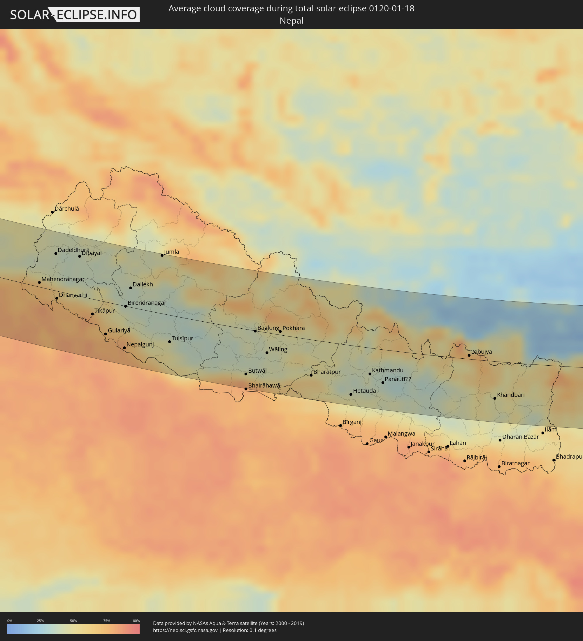 Nepal
Nepal
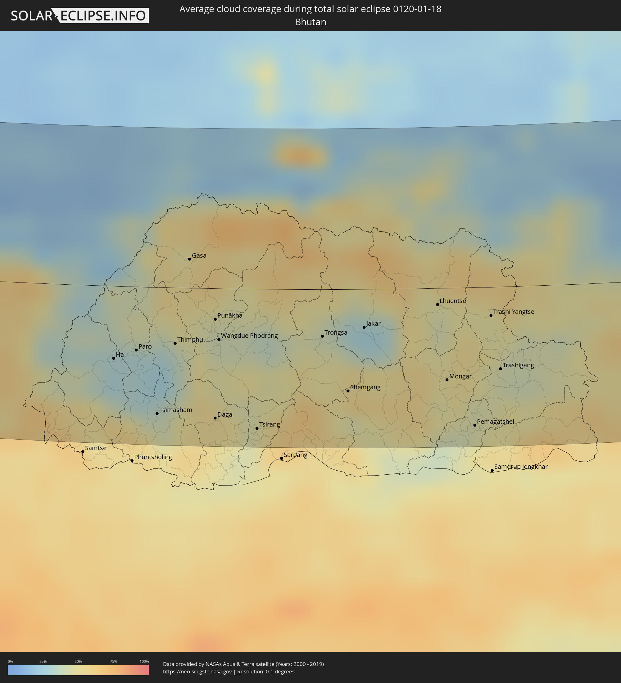 Bhutan
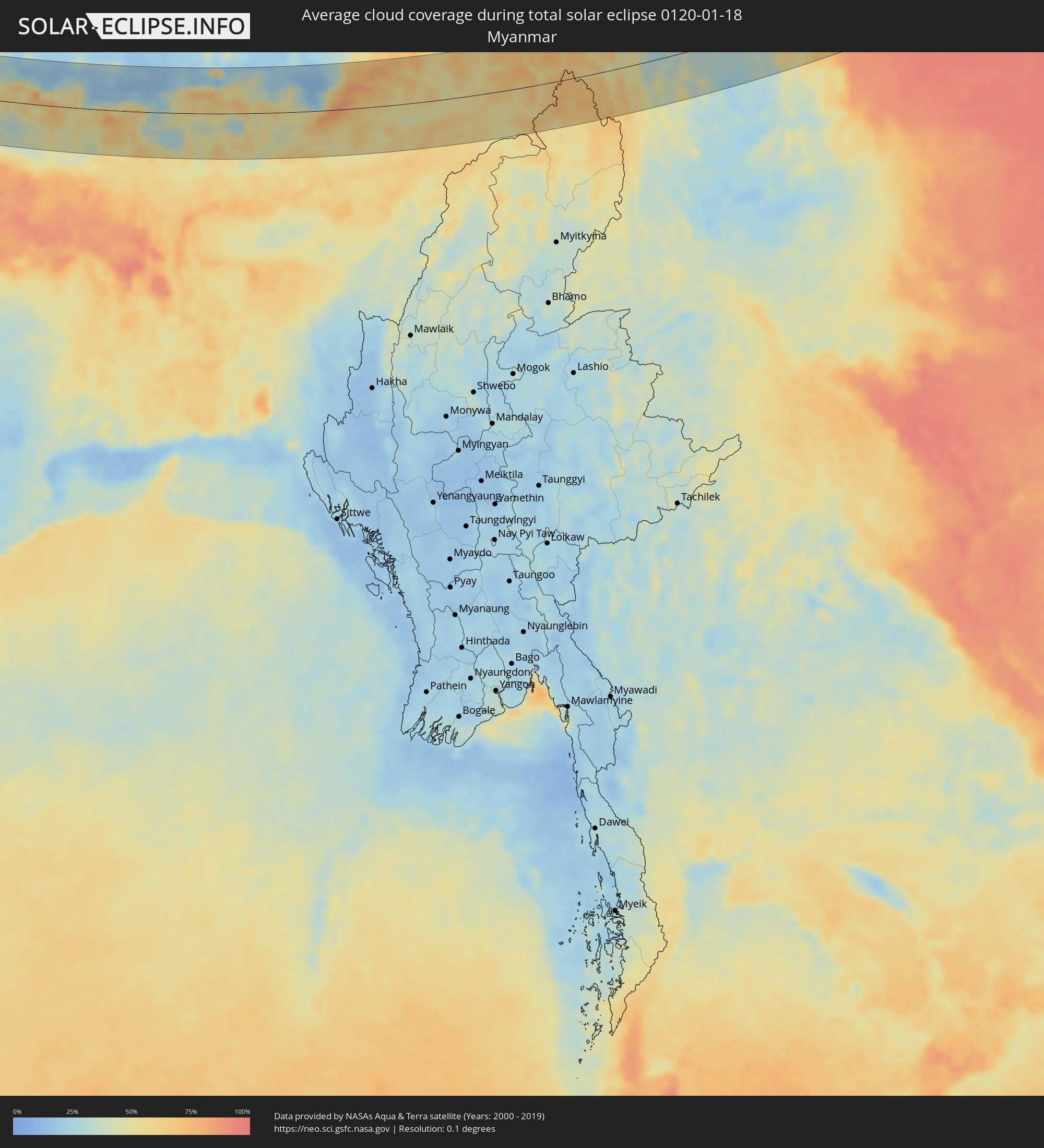 Myanmar
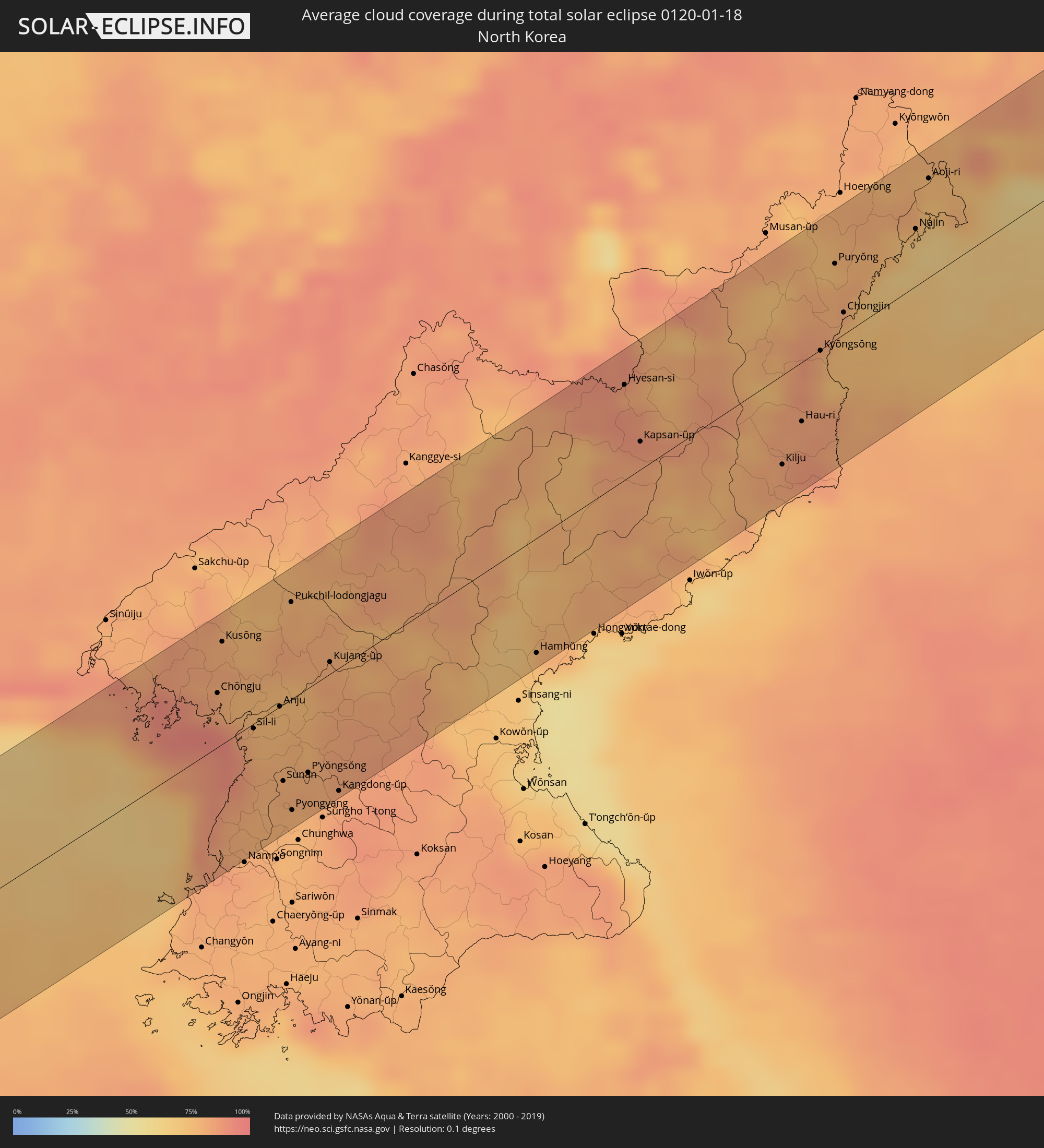 North Korea
Cities inside the path of the eclipse
The following table shows all locations with a population of more than 5,000 inside the eclipse path. Cities which have more than 100,000 inhabitants are marked bold. A click at the locations opens a detailed map.
| City | Type | Eclipse duration | Local time of max. eclipse | Distance to central line | Ø Cloud coverage |
|
Beylagan, Beyləqan
|
total | - | 07:38:40 UTC+03:19 | 53 km | 75% |
|
Zardob, Zərdab
|
total | - | 07:39:15 UTC+03:19 | 6 km | 80% |
|
Dünyamalılar, Beyləqan
|
total | - | 07:38:44 UTC+03:19 | 48 km | 76% |
|
Pārsābād, Ardabīl
|
total | - | 07:44:59 UTC+03:25 | 54 km | 73% |
|
Imishli, İmişli
|
total | - | 07:39:00 UTC+03:19 | 26 km | 78% |
|
Kyurdarmir, Kürdǝmir
|
total | - | 07:39:38 UTC+03:19 | 24 km | 79% |
|
Saatlı, Saatlı
|
total | - | 07:39:14 UTC+03:19 | 8 km | 75% |
|
Əhmədbəyli, Saatlı
|
total | - | 07:39:11 UTC+03:19 | 12 km | 75% |
|
Aghsu, Ağsu
|
total | - | 07:40:02 UTC+03:19 | 56 km | 79% |
|
Sabirabad, Sabirabad
|
total | - | 07:39:23 UTC+03:19 | 4 km | 75% |
|
Pushkino, Bilǝsuvar
|
total | - | 07:38:45 UTC+03:19 | 47 km | 74% |
|
Şirvan, Shirvan
|
total | - | 07:39:32 UTC+03:19 | 15 km | 76% |
|
Hacıqabul, Hacıqabul
|
total | - | 07:39:40 UTC+03:19 | 26 km | 81% |
|
Salyan, Salyan
|
total | - | 07:39:09 UTC+03:19 | 16 km | 76% |
|
Neftçala, Neftçala
|
total | - | 07:39:02 UTC+03:19 | 27 km | 74% |
|
Severo-Vostotchnyi Bank, Neftçala
|
total | - | 07:39:05 UTC+03:19 | 24 km | 74% |
|
Qobustan, Baki
|
total | - | 07:39:59 UTC+03:19 | 49 km | 79% |
|
Āq Qāyeh, Golestān
|
total | - | 07:46:48 UTC+03:25 | 1 km | 60% |
|
Gonbad-e Kāvūs, Golestān
|
total | - | 07:46:47 UTC+03:25 | 1 km | 60% |
|
Āzādshahr, Golestān
|
total | - | 07:46:36 UTC+03:25 | 17 km | 54% |
|
Kalāleh, Golestān
|
total | - | 07:47:11 UTC+03:25 | 25 km | 55% |
|
Sabzevar, Razavi Khorasan
|
total | - | 07:47:41 UTC+03:25 | 4 km | 60% |
|
Nīshābūr, Razavi Khorasan
|
total | - | 07:48:41 UTC+03:25 | 40 km | 58% |
|
Torbat-e Ḩeydarīyeh, Razavi Khorasan
|
total | - | 07:48:03 UTC+03:25 | 38 km | 61% |
|
Torbat-e Jām, Razavi Khorasan
|
total | - | 07:49:23 UTC+03:25 | 14 km | 59% |
|
Tāybād, Razavi Khorasan
|
total | - | 07:49:00 UTC+03:25 | 31 km | 60% |
|
Kafir Qala, Herat
|
total | - | 08:23:29 UTC+04:00 | 27 km | 62% |
|
Kuhsān, Herat
|
total | - | 08:23:37 UTC+04:00 | 23 km | 64% |
|
Tīr Pul, Herat
|
total | - | 08:23:37 UTC+04:00 | 27 km | 65% |
|
Zindah Jān, Herat
|
total | - | 08:23:51 UTC+04:00 | 34 km | 59% |
|
Qarah Bāgh, Herat
|
total | - | 08:24:31 UTC+04:00 | 28 km | 64% |
|
Chahār Burj, Herat
|
total | - | 08:24:14 UTC+04:00 | 26 km | 62% |
|
Herāt, Herat
|
total | - | 08:24:21 UTC+04:00 | 16 km | 65% |
|
Karukh, Herat
|
total | - | 08:24:55 UTC+04:00 | 13 km | 64% |
|
Shahrak, Ghowr
|
total | - | 08:26:29 UTC+04:00 | 40 km | 63% |
|
Tarinkot, Oruzgan
|
total | - | 08:26:55 UTC+04:00 | 52 km | 61% |
|
Nīlī, Daykundi
|
total | - | 08:28:20 UTC+04:00 | 69 km | 69% |
|
Uruzgān, Oruzgan
|
total | - | 08:28:11 UTC+04:00 | 6 km | 68% |
|
Qalāt, Zabul
|
total | - | 08:27:45 UTC+04:00 | 68 km | 61% |
|
Zarghūn Shahr, Paktika
|
total | - | 08:30:33 UTC+04:00 | 63 km | 58% |
|
Dera Ismāīl Khān, Khyber Pakhtunkhwa
|
total | - | 09:01:23 UTC+04:28 | 44 km | 73% |
|
Layyah, Punjab
|
total | - | 09:00:39 UTC+04:28 | 46 km | 72% |
|
Bhakkar, Punjab
|
total | - | 09:01:27 UTC+04:28 | 28 km | 74% |
|
Jhang Sadr, Punjab
|
total | - | 09:03:07 UTC+04:28 | 32 km | 72% |
|
Miān Channūn, Punjab
|
total | - | 09:02:25 UTC+04:28 | 54 km | 76% |
|
Būrewāla, Punjab
|
total | - | 09:02:40 UTC+04:28 | 73 km | 77% |
|
Kamālia, Punjab
|
total | - | 09:03:10 UTC+04:28 | 14 km | 80% |
|
Gojra, Punjab
|
total | - | 09:03:36 UTC+04:28 | 31 km | 73% |
|
Chīchāwatni, Punjab
|
total | - | 09:03:04 UTC+04:28 | 33 km | 83% |
|
Ārifwāla, Punjab
|
total | - | 09:03:28 UTC+04:28 | 46 km | 79% |
|
Faisalābād, Punjab
|
total | - | 09:04:29 UTC+04:28 | 72 km | 79% |
|
Sahiwal, Punjab
|
total | - | 09:03:51 UTC+04:28 | 6 km | 80% |
|
Bahāwalnagar, Punjab
|
total | - | 09:03:31 UTC+04:28 | 72 km | 74% |
|
Pākpattan, Punjab
|
total | - | 09:04:02 UTC+04:28 | 31 km | 76% |
|
Bahāwalnagar, Punjab
|
total | - | 09:04:14 UTC+04:28 | 9 km | 79% |
|
Jarānwāla, Punjab
|
total | - | 09:05:00 UTC+04:28 | 74 km | 77% |
|
Okāra, Punjab
|
total | - | 09:04:33 UTC+04:28 | 20 km | 79% |
|
Dīpālpur, Punjab
|
total | - | 09:04:47 UTC+04:28 | 12 km | 84% |
|
Pattoki, Punjab
|
total | - | 09:05:25 UTC+04:28 | 54 km | 79% |
|
Gangānagar, Rajasthan
|
total | - | 09:57:28 UTC+05:21 | 61 km | 74% |
|
Bhāi Pheru, Punjab
|
total | - | 09:05:45 UTC+04:28 | 77 km | 79% |
|
Bhatinda, Punjab
|
total | - | 09:59:34 UTC+05:21 | 2 km | 73% |
|
Sirsa, Haryana
|
total | - | 09:59:10 UTC+05:21 | 67 km | 74% |
|
Gorakhpur, Haryana
|
total | - | 10:00:15 UTC+05:21 | 57 km | 75% |
|
Jīnd, Haryana
|
total | - | 10:01:20 UTC+05:21 | 53 km | 77% |
|
Patiāla, Punjab
|
total | - | 10:02:19 UTC+05:21 | 58 km | 77% |
|
Pānīpat, Haryana
|
total | - | 10:02:37 UTC+05:21 | 27 km | 81% |
|
Karnāl, Haryana
|
total | - | 10:02:53 UTC+05:21 | 6 km | 79% |
|
Sonīpat, Haryana
|
total | - | 10:02:23 UTC+05:21 | 68 km | 81% |
|
Yamunānagar, Haryana
|
total | - | 10:03:49 UTC+05:21 | 61 km | 80% |
|
Sahāranpur, Uttar Pradesh
|
total | - | 10:04:11 UTC+05:21 | 51 km | 80% |
|
Muzaffarnagar, Uttar Pradesh
|
total | - | 10:04:05 UTC+05:21 | 2 km | 81% |
|
Meerut, Uttar Pradesh
|
total | - | 10:03:42 UTC+05:21 | 51 km | 83% |
|
Hāpur, Uttar Pradesh
|
total | - | 10:03:39 UTC+05:21 | 76 km | 83% |
|
Haridwar, Uttarakhand
|
total | - | 10:05:21 UTC+05:21 | 65 km | 70% |
|
Amroha, Uttar Pradesh
|
total | - | 10:05:08 UTC+05:21 | 40 km | 80% |
|
Sambhal, Uttar Pradesh
|
total | - | 10:05:05 UTC+05:21 | 71 km | 85% |
|
Morādābād, Uttar Pradesh
|
total | - | 10:05:42 UTC+05:21 | 39 km | 79% |
|
Rāmpur, Uttar Pradesh
|
total | - | 10:06:11 UTC+05:21 | 36 km | 80% |
|
Bareilly, Uttar Pradesh
|
total | - | 10:06:37 UTC+05:21 | 77 km | 84% |
|
Mahendranagar, Far Western
|
total | - | 10:29:02 UTC+05:41 | 6 km | 73% |
|
Dhangarhi, Far Western
|
total | - | 10:29:26 UTC+05:41 | 11 km | 76% |
|
Dipayal, Far Western
|
total | - | 10:30:34 UTC+05:41 | 57 km | 38% |
|
Tīkāpur, Far Western
|
total | - | 10:30:25 UTC+05:41 | 22 km | 79% |
|
Gulariyā, Mid Western
|
total | - | 10:30:39 UTC+05:41 | 47 km | 77% |
|
Nepalgunj, Mid Western
|
total | - | 10:31:07 UTC+05:41 | 61 km | 79% |
|
Birendranagar, Mid Western
|
total | - | 10:31:34 UTC+05:41 | 1 km | 46% |
|
Dailekh, Mid Western
|
total | - | 10:31:54 UTC+05:41 | 27 km | 36% |
|
Tulsīpur, Mid Western
|
total | - | 10:32:40 UTC+05:41 | 39 km | 51% |
|
Butwāl, Western Region
|
total | - | 10:34:56 UTC+05:41 | 66 km | 80% |
|
Tānsen, Western Region
|
total | - | 10:35:16 UTC+05:41 | 46 km | 41% |
|
Bāglung, Western Region
|
total | - | 10:35:39 UTC+05:41 | 1 km | 40% |
|
Wāling, Western Region
|
total | - | 10:35:51 UTC+05:41 | 30 km | 43% |
|
Pokhara, Western Region
|
total | - | 10:36:30 UTC+05:41 | 5 km | 46% |
|
Bharatpur, Central Region
|
total | - | 10:37:10 UTC+05:41 | 53 km | 62% |
|
Hetauda, Central Region
|
total | - | 10:38:24 UTC+05:41 | 73 km | 50% |
|
Kirtipur, Central Region
|
total | - | 10:39:08 UTC+05:41 | 42 km | 43% |
|
Kathmandu, Central Region
|
total | - | 10:39:15 UTC+05:41 | 39 km | 43% |
|
Panauti̇̄, Central Region
|
total | - | 10:39:38 UTC+05:41 | 49 km | 37% |
|
Khāndbāri, Eastern Region
|
total | - | 10:43:34 UTC+05:41 | 55 km | 47% |
|
Ha, Haa District
|
total | - | 11:06:03 UTC+05:58 | 42 km | 29% |
|
Paro, Paro
|
total | - | 11:06:25 UTC+05:58 | 37 km | 30% |
|
Tsimasham, Chukha District
|
total | - | 11:06:32 UTC+05:58 | 73 km | 53% |
|
Thimphu, Thimphu
|
total | - | 11:07:01 UTC+05:58 | 32 km | 31% |
|
Lungtenzampa, Thimphu
|
total | - | 11:07:01 UTC+05:58 | 32 km | 31% |
|
Gasa, Gasa District
|
total | - | 11:07:29 UTC+05:58 | 16 km | 53% |
|
Daga, Dagana District
|
total | - | 11:07:23 UTC+05:58 | 75 km | 53% |
|
Punākha, Punakha
|
total | - | 11:07:41 UTC+05:58 | 18 km | 41% |
|
Wangdue Phodrang, Wangdi Phodrang
|
total | - | 11:07:41 UTC+05:58 | 30 km | 42% |
|
Tsirang, Chirang
|
total | - | 11:07:59 UTC+05:58 | 81 km | 44% |
|
Trongsa, Tongsa
|
total | - | 11:09:14 UTC+05:58 | 27 km | 47% |
|
Shemgang, Shemgang
|
total | - | 11:09:28 UTC+05:58 | 59 km | 46% |
|
Jakar, Bumthang
|
total | - | 11:09:53 UTC+05:58 | 22 km | 33% |
|
Lhuentse, Lhuntse District
|
total | - | 11:11:03 UTC+05:58 | 10 km | 43% |
|
Mongar, Mongar District
|
total | - | 11:10:59 UTC+05:58 | 54 km | 47% |
|
Pemagatshel, Pemagatshel District
|
total | - | 11:11:17 UTC+05:58 | 80 km | 50% |
|
Trashi Yangtse, Trashi Yangste
|
total | - | 11:11:50 UTC+05:58 | 17 km | 47% |
|
Trashigang, Tashigang
|
total | - | 11:11:50 UTC+05:58 | 48 km | 48% |
|
Chengdu, Sichuan
|
total | - | 13:46:39 UTC+08:00 | 73 km | 94% |
|
Neijiang, Sichuan
|
total | - | 13:48:55 UTC+08:00 | 74 km | 94% |
|
Nanchong, Sichuan
|
total | - | 13:51:32 UTC+08:00 | 15 km | 92% |
|
Wanxian, Chongqing
|
total | - | 13:56:53 UTC+08:00 | 70 km | 96% |
|
Shiyan, Hubei
|
total | - | 14:02:11 UTC+08:00 | 16 km | 73% |
|
Laohekou, Hubei
|
total | - | 14:04:06 UTC+08:00 | 48 km | 85% |
|
Nanyang, Henan
|
total | - | 14:05:50 UTC+08:00 | 25 km | 86% |
|
Pingdingshan, Henan
|
total | - | 14:07:16 UTC+08:00 | 14 km | 83% |
|
Jiangguanchi, Henan
|
total | - | 14:08:12 UTC+08:00 | 30 km | 84% |
|
Luohe, Henan
|
total | - | 14:08:47 UTC+08:00 | 36 km | 86% |
|
Kaifeng, Henan
|
total | - | 14:09:02 UTC+08:00 | 72 km | 85% |
|
Zhoukou, Henan
|
total | - | 14:09:55 UTC+08:00 | 56 km | 83% |
|
Heze, Shandong
|
total | - | 14:11:08 UTC+08:00 | 62 km | 83% |
|
Jining, Shandong
|
total | - | 14:13:08 UTC+08:00 | 27 km | 84% |
|
Zoucheng, Shandong
|
total | - | 14:13:49 UTC+08:00 | 9 km | 82% |
|
Zaozhuang, Shandong
|
total | - | 14:15:03 UTC+08:00 | 69 km | 83% |
|
Xintai, Shandong
|
total | - | 14:15:03 UTC+08:00 | 21 km | 79% |
|
Weifang, Shandong
|
total | - | 14:17:03 UTC+08:00 | 35 km | 85% |
|
Zhu Cheng City, Shandong
|
total | - | 14:17:51 UTC+08:00 | 47 km | 81% |
|
Yantai, Shandong
|
total | - | 14:20:30 UTC+08:00 | 2 km | 84% |
|
Chŏngju, P'yŏngan-bukto
|
total | - | 14:47:45 UTC+08:23 | 28 km | 83% |
|
Kusŏng, P'yŏngan-bukto
|
total | - | 14:47:37 UTC+08:23 | 54 km | 81% |
|
Sil-li, P'yŏngan-namdo
|
total | - | 14:48:13 UTC+08:23 | 2 km | 78% |
|
Sinanju, P'yŏngan-namdo
|
total | - | 14:48:21 UTC+08:23 | 1 km | 76% |
|
Anju, P'yŏngan-namdo
|
total | - | 14:48:24 UTC+08:23 | 1 km | 76% |
|
Sunan, Pyongyang
|
total | - | 14:48:42 UTC+08:23 | 40 km | 81% |
|
Pyongyang, Pyongyang
|
total | - | 14:48:53 UTC+08:23 | 59 km | 78% |
|
P’yŏngsŏng, P'yŏngan-namdo
|
total | - | 14:48:55 UTC+08:23 | 44 km | 81% |
|
Kujang-ŭp, P'yŏngan-bukto
|
total | - | 14:48:44 UTC+08:23 | 6 km | 80% |
|
Kangdong-ŭp, Pyongyang
|
total | - | 14:49:16 UTC+08:23 | 65 km | 82% |
|
Yŏnggwang-ŭp, Hamgyŏng-namdo
|
total | - | 14:50:28 UTC+08:23 | 46 km | 72% |
|
Hamhŭng, Hamgyŏng-namdo
|
total | - | 14:50:38 UTC+08:23 | 59 km | 73% |
|
Hyesan-si, Yanggang-do
|
total | - | 14:50:24 UTC+08:23 | 48 km | 82% |
|
Kapsan-ŭp, Yanggang-do
|
total | - | 14:50:45 UTC+08:23 | 14 km | 87% |
|
Kilju, Hamgyŏng-bukto
|
total | - | 14:52:04 UTC+08:23 | 45 km | 81% |
|
Kyŏngsŏng, Hamgyŏng-bukto
|
total | - | 14:51:56 UTC+08:23 | 1 km | 82% |
|
Chongjin, Hamgyŏng-bukto
|
total | - | 14:51:59 UTC+08:23 | 11 km | 75% |
|
Najin, Rason
|
total | - | 14:52:13 UTC+08:23 | 29 km | 65% |
|
Aoji-ri, Hamgyŏng-bukto
|
total | - | 14:52:07 UTC+08:23 | 49 km | 75% |
|
Sŏnbong, Rason
|
total | - | 14:52:15 UTC+08:23 | 33 km | 65% |
|
Slavyanka, Primorskiy
|
total | - | 15:17:26 UTC+08:47 | 36 km | 86% |
|
Tavrichanka, Primorskiy
|
total | - | 15:17:33 UTC+08:47 | 56 km | 93% |
|
Vladivostok, Primorskiy
|
total | - | 15:17:45 UTC+08:47 | 36 km | 89% |
|
Vol’no-Nadezhdinskoye, Primorskiy
|
total | - | 15:17:39 UTC+08:47 | 55 km | 84% |
|
Trudovoye, Primorskiy
|
total | - | 15:17:47 UTC+08:47 | 45 km | 88% |
|
Uglovoye, Primorskiy
|
total | - | 15:17:47 UTC+08:47 | 46 km | 88% |
|
Artëm, Primorskiy
|
total | - | 15:17:52 UTC+08:47 | 45 km | 81% |
|
Zavodskoy, Primorskiy
|
total | - | 15:17:52 UTC+08:47 | 50 km | 80% |
|
Dunay, Primorskiy
|
total | - | 15:18:24 UTC+08:47 | 6 km | 76% |
|
Bol’shoy Kamen’, Primorskiy
|
total | - | 15:18:14 UTC+08:47 | 14 km | 82% |
|
Fokino, Primorskiy
|
total | - | 15:18:24 UTC+08:47 | 1 km | 82% |
|
Livadiya, Primorskiy
|
total | - | 15:18:46 UTC+08:47 | 23 km | 68% |
|
Nakhodka, Primorskiy
|
total | - | 15:19:01 UTC+08:47 | 37 km | 65% |
|
Vrangel’, Primorskiy
|
total | - | 15:19:17 UTC+08:47 | 54 km | 57% |
|
Partizansk, Primorskiy
|
total | - | 15:19:00 UTC+08:47 | 20 km | 80% |
|
Chuguyevka, Primorskiy
|
total | - | 15:18:50 UTC+08:47 | 43 km | 87% |
|
Kavalerovo, Primorskiy
|
total | - | 15:19:51 UTC+08:47 | 0 km | 83% |
|
Dal'negorsk, Primorskiy
|
total | - | 15:20:04 UTC+08:47 | 3 km | 80% |
|
Kholmsk, Sakhalin
|
total | - | 16:50:02 UTC+10:14 | 49 km | 84% |
|
Dolinsk, Sakhalin
|
total | - | 16:50:14 UTC+10:14 | 54 km | 75% |