Total solar eclipse of 01/14/0484
| Day of week: | Friday |
| Maximum duration of eclipse: | 03m04s |
| Maximum width of eclipse path: | 232 km |
| Saros cycle: | 97 |
| Coverage: | 100% |
| Magnitude: | 1.0366 |
| Gamma: | 0.8499 |
Wo kann man die Sonnenfinsternis vom 01/14/0484 sehen?
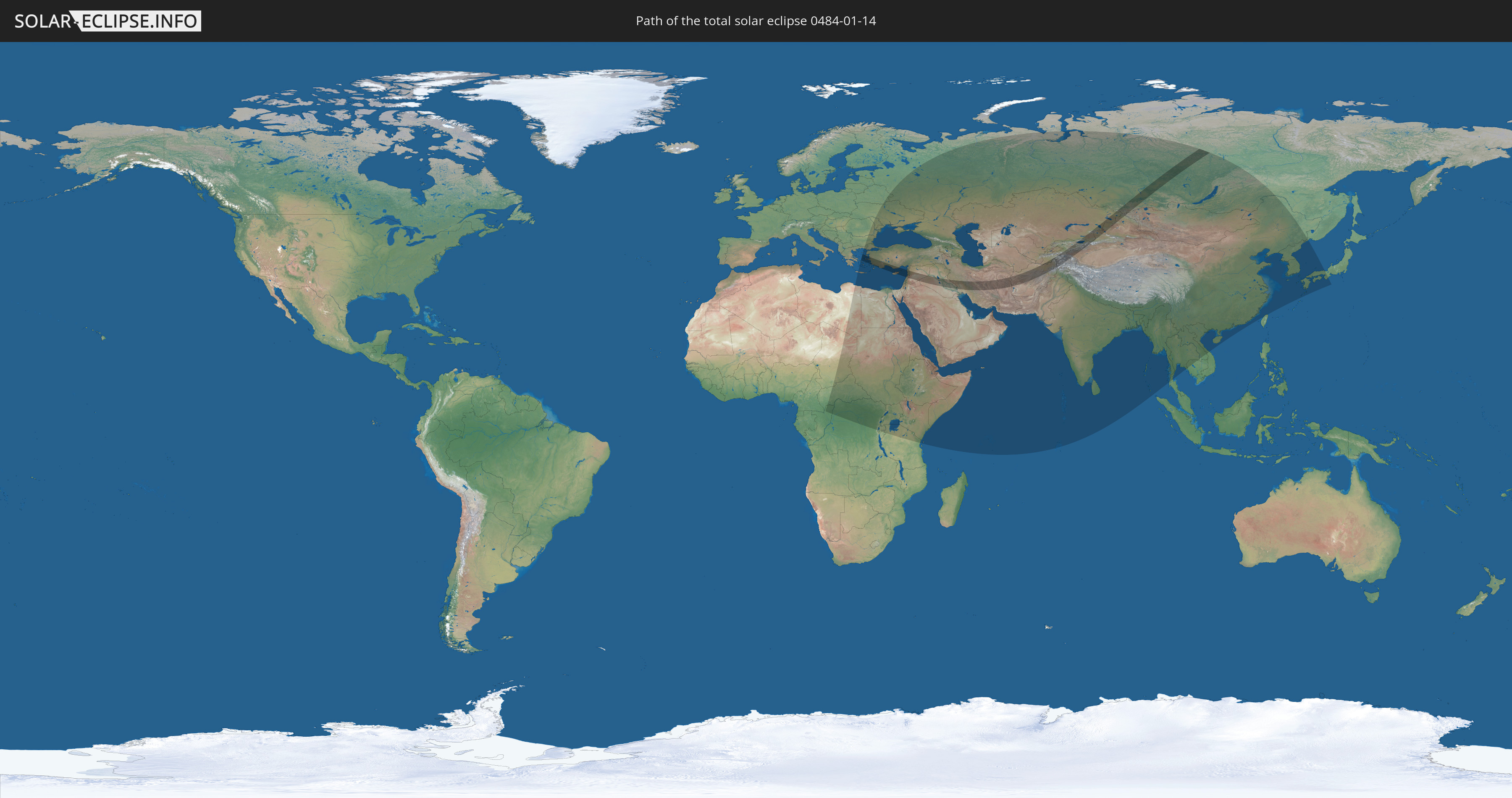
Die Sonnenfinsternis am 01/14/0484 kann man in 70 Ländern als partielle Sonnenfinsternis beobachten.
Der Finsternispfad verläuft durch 15 Länder. Nur in diesen Ländern ist sie als total Sonnenfinsternis zu sehen.
In den folgenden Ländern ist die Sonnenfinsternis total zu sehen
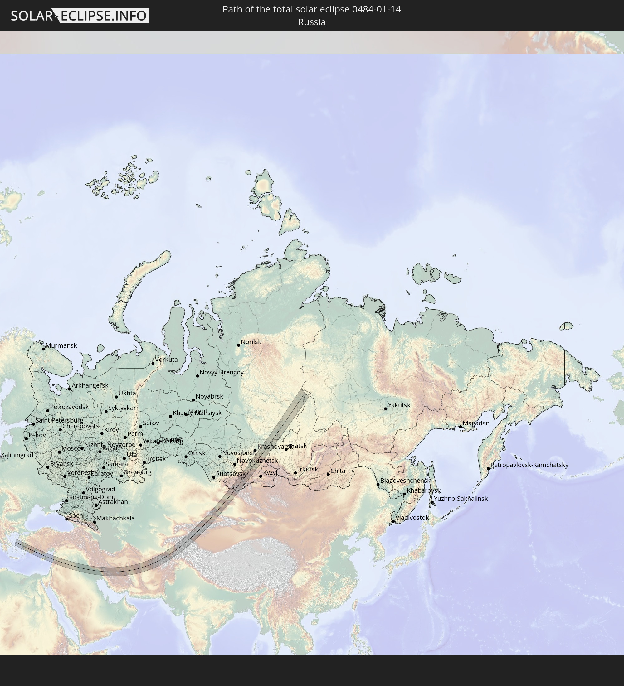 Russia
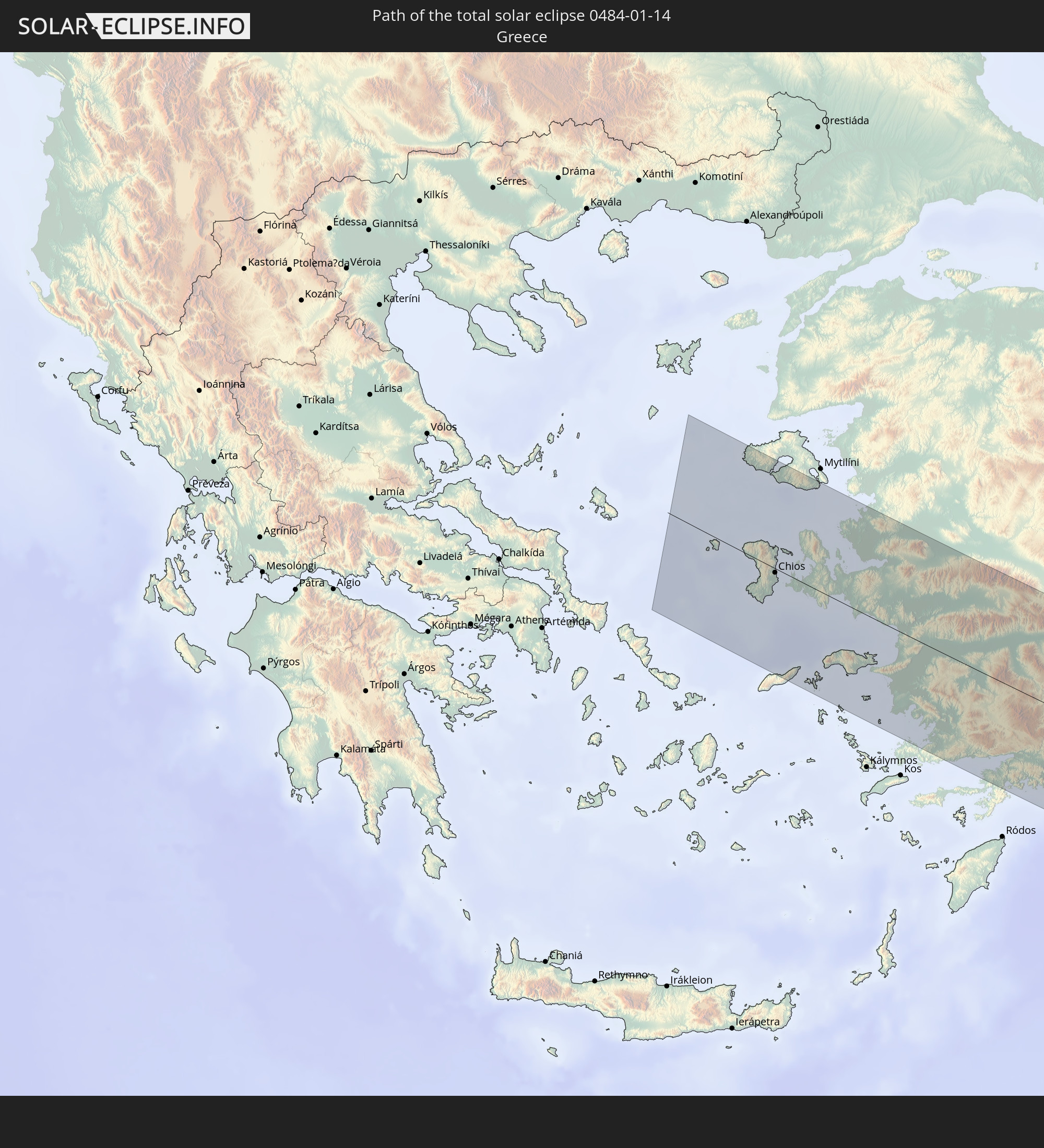 Greece
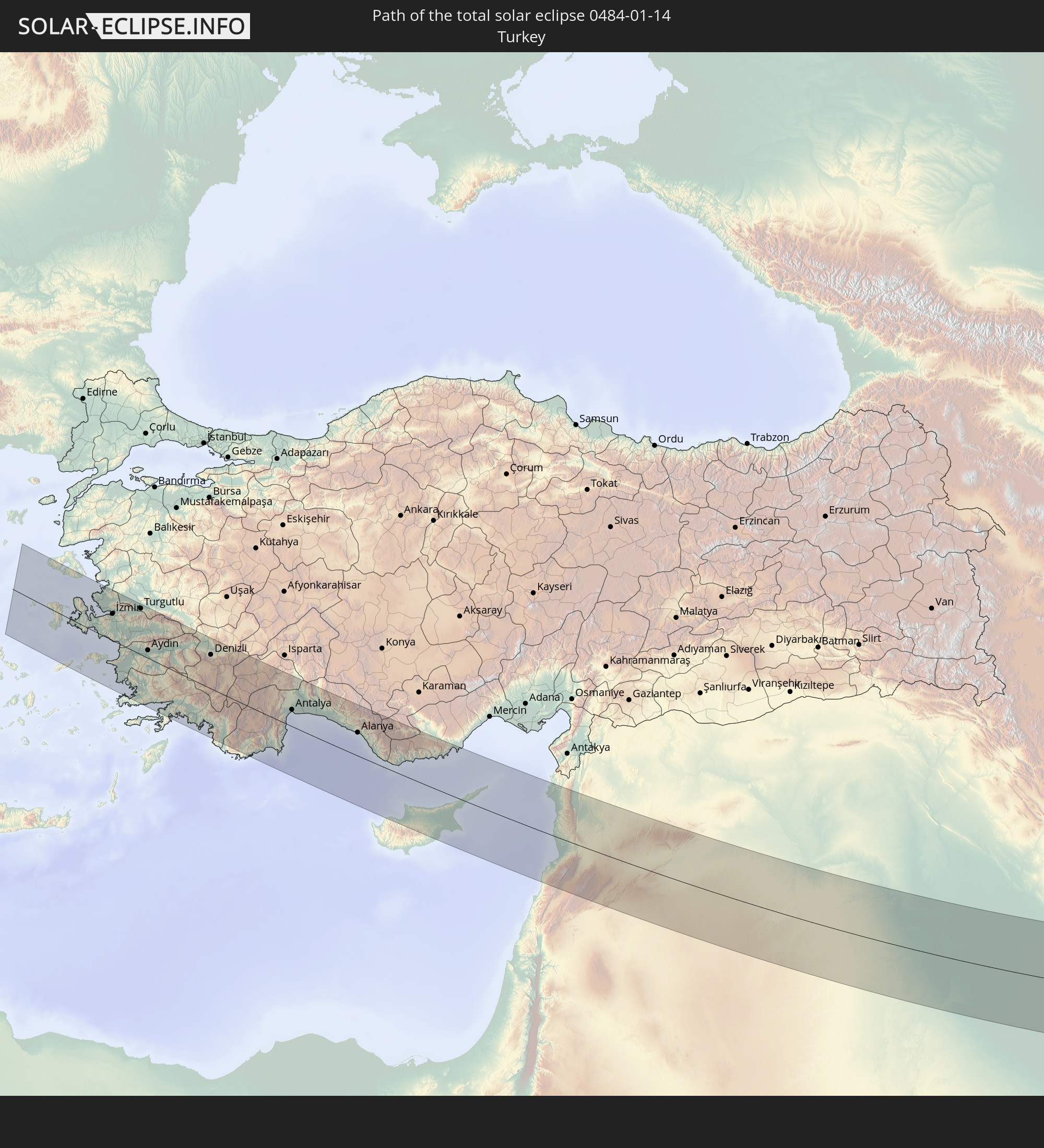 Turkey
 Cyprus
 Jordan
 Lebanon
 Syria
Syria
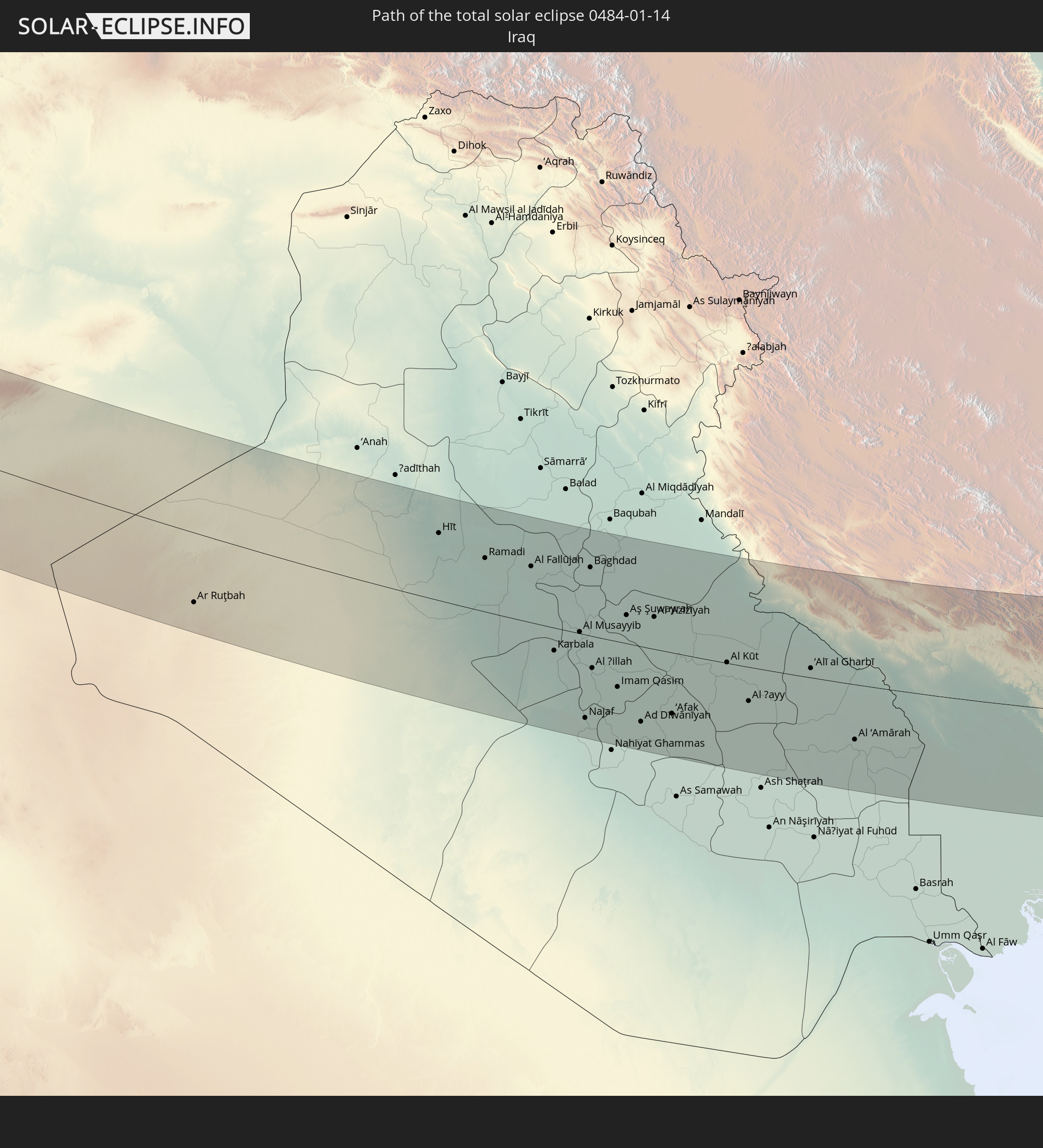 Iraq
Iraq
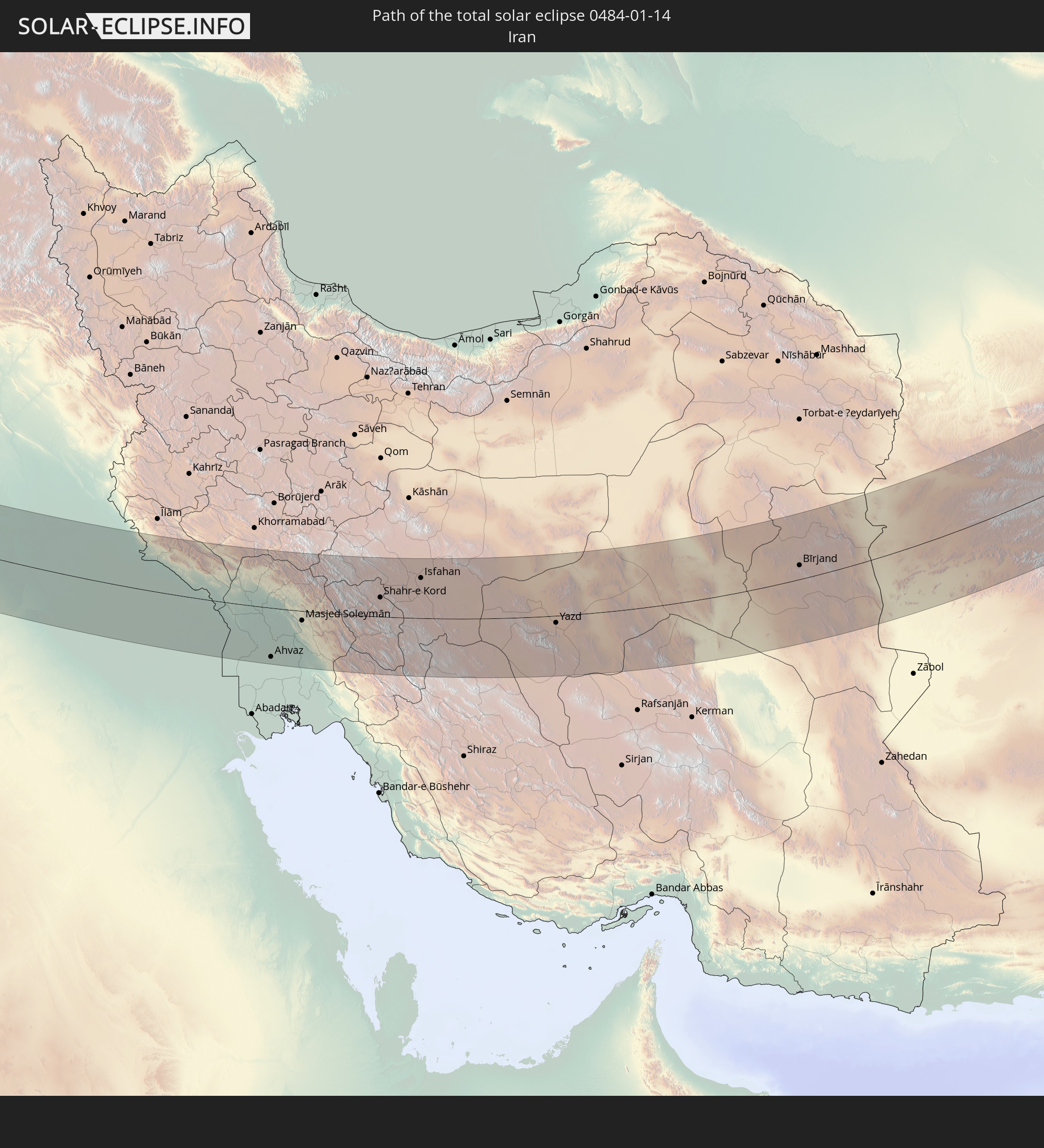 Iran
Iran
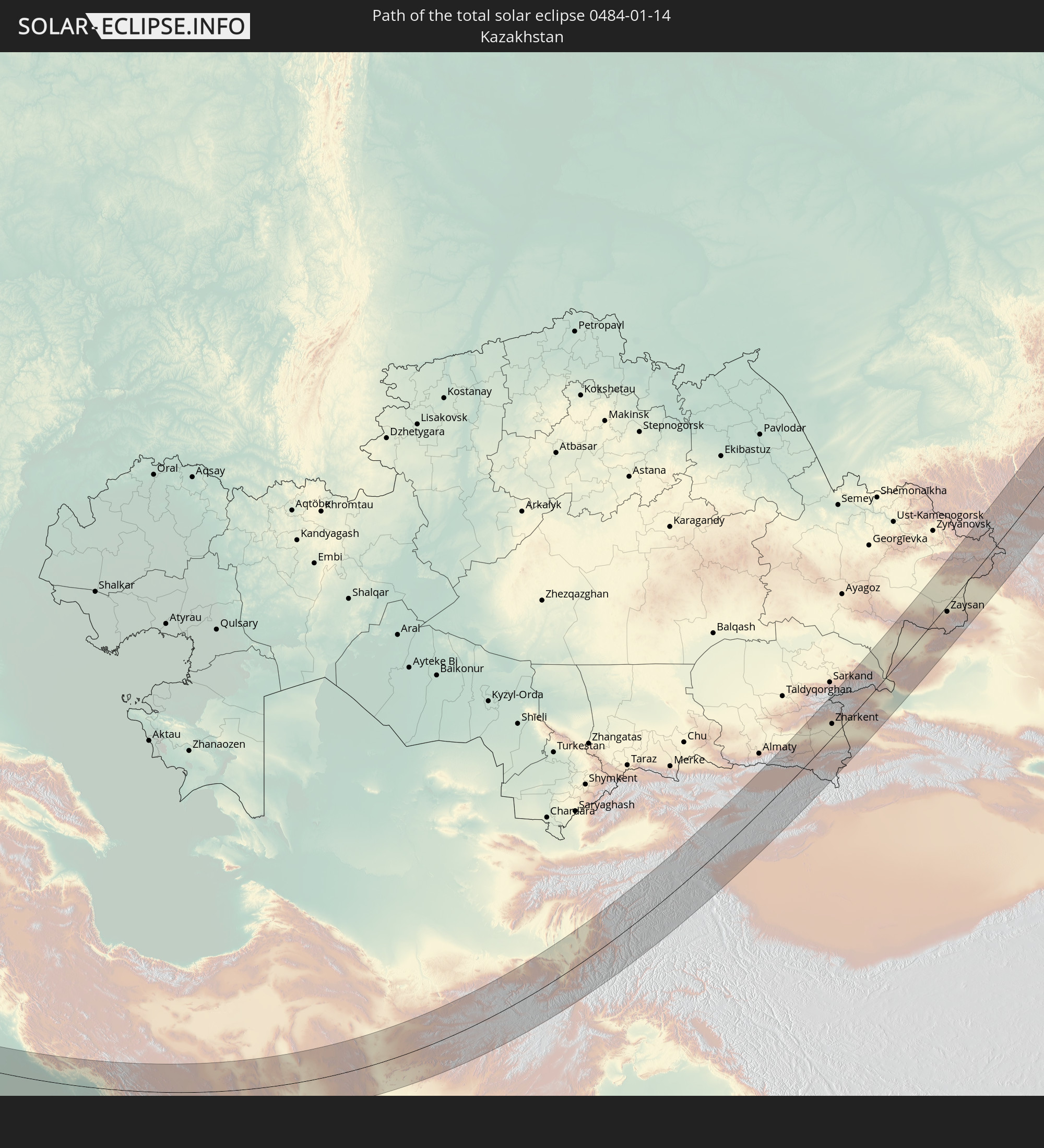 Kazakhstan
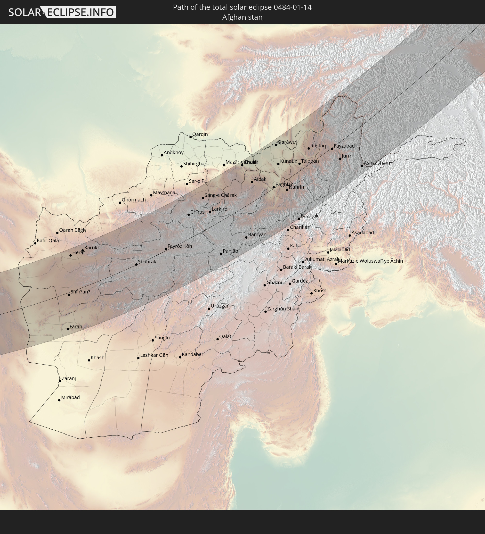 Afghanistan
 Tajikistan
 Kyrgyzstan
 China
China
 Mongolia
In den folgenden Ländern ist die Sonnenfinsternis partiell zu sehen
 Russia
 Libya
Libya
 Republic of the Congo
 Democratic Republic of the Congo
 Chad
Chad
 Central African Republic
 Greece
 Romania
 Sudan
Sudan
 Ukraine
 Bulgaria
 Belarus
 Egypt
Egypt
 Turkey
 Moldova
 Rwanda
 Burundi
 Tanzania
 Uganda
 Cyprus
 Ethiopia
 Kenya
Kenya
 State of Palestine
 Israel
 Saudi Arabia
 Jordan
 Lebanon
 Syria
Syria
 Eritrea
 Iraq
Iraq
 Georgia
 Somalia
 Djibouti
 Yemen
Yemen
 Armenia
 Iran
Iran
 Azerbaijan
 Seychelles
 Kazakhstan
 Kuwait
 Bahrain
 Qatar
Qatar
 United Arab Emirates
 Oman
Oman
 Turkmenistan
 Uzbekistan
 Afghanistan
 Pakistan
 Tajikistan
 India
India
 Kyrgyzstan
 British Indian Ocean Territory
 Maldives
 China
China
 Sri Lanka
 Nepal
Nepal
 Mongolia
 Bangladesh
 Bhutan
 Myanmar
 Thailand
 Laos
Laos
 Vietnam
 Cambodia
 Macau
Macau
 Hong Kong
 Taiwan
 Japan
Japan
 North Korea
 South Korea
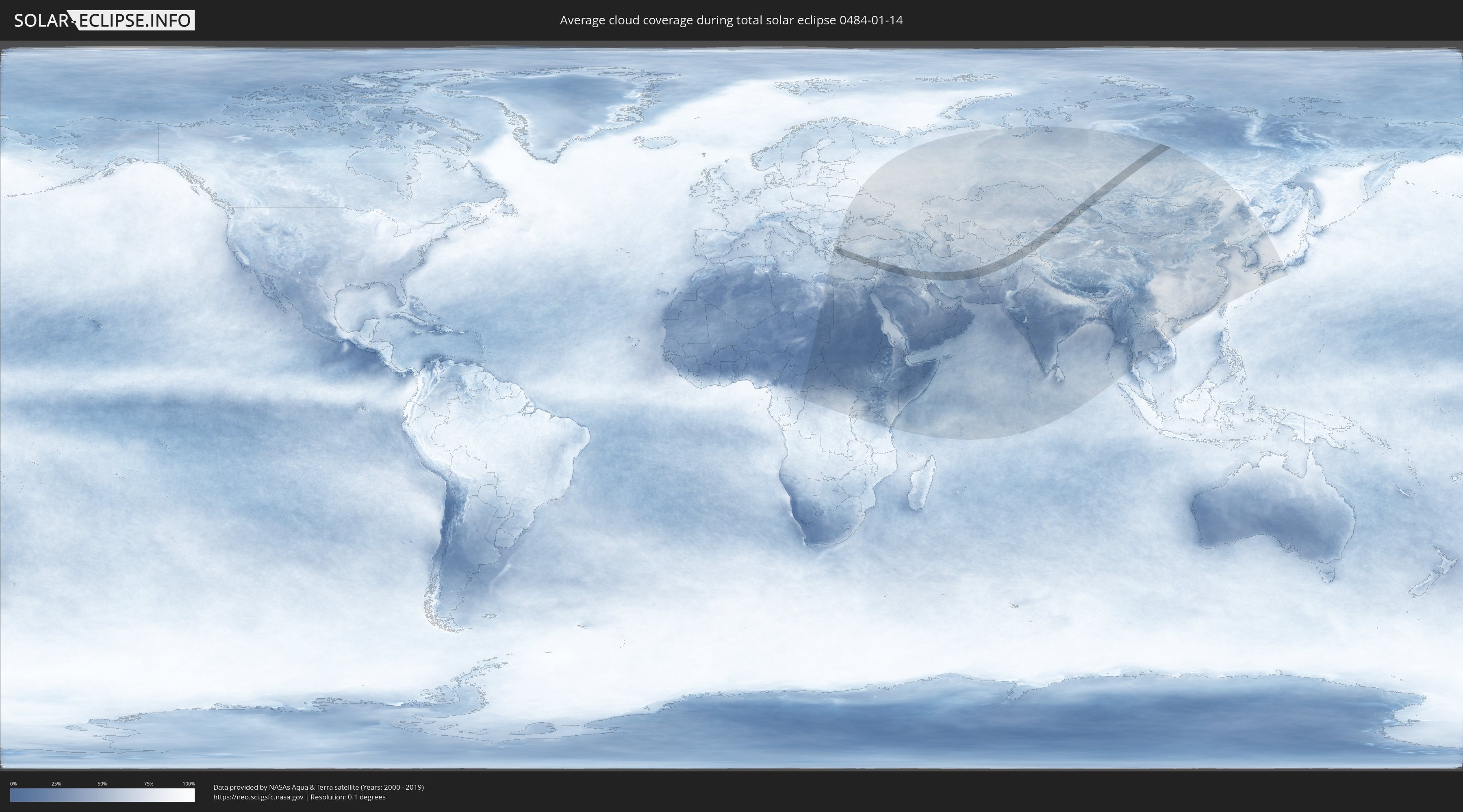
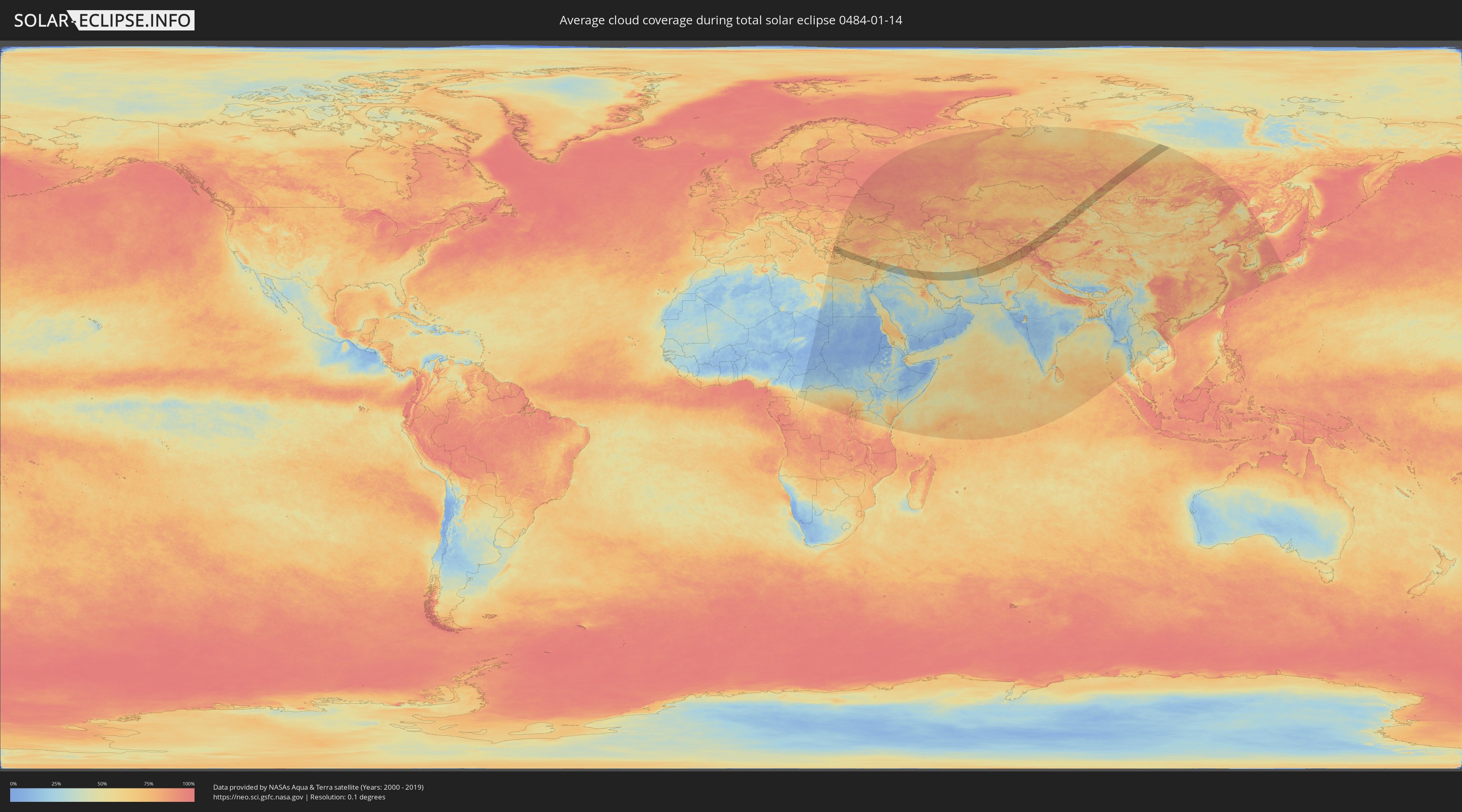
How will be the weather during the total solar eclipse on 01/14/0484?
Where is the best place to see the total solar eclipse of 01/14/0484?
The following maps show the average cloud coverage for the day of the total solar eclipse.
With the help of these maps, it is possible to find the place along the eclipse path, which has the best
chance of a cloudless sky.
Nevertheless, you should consider local circumstances and inform about the weather of your chosen
observation site.
The data is provided by NASAs satellites
AQUA and TERRA.
The cloud maps are averaged over a period of 19 years (2000 - 2019).
Detailed country maps
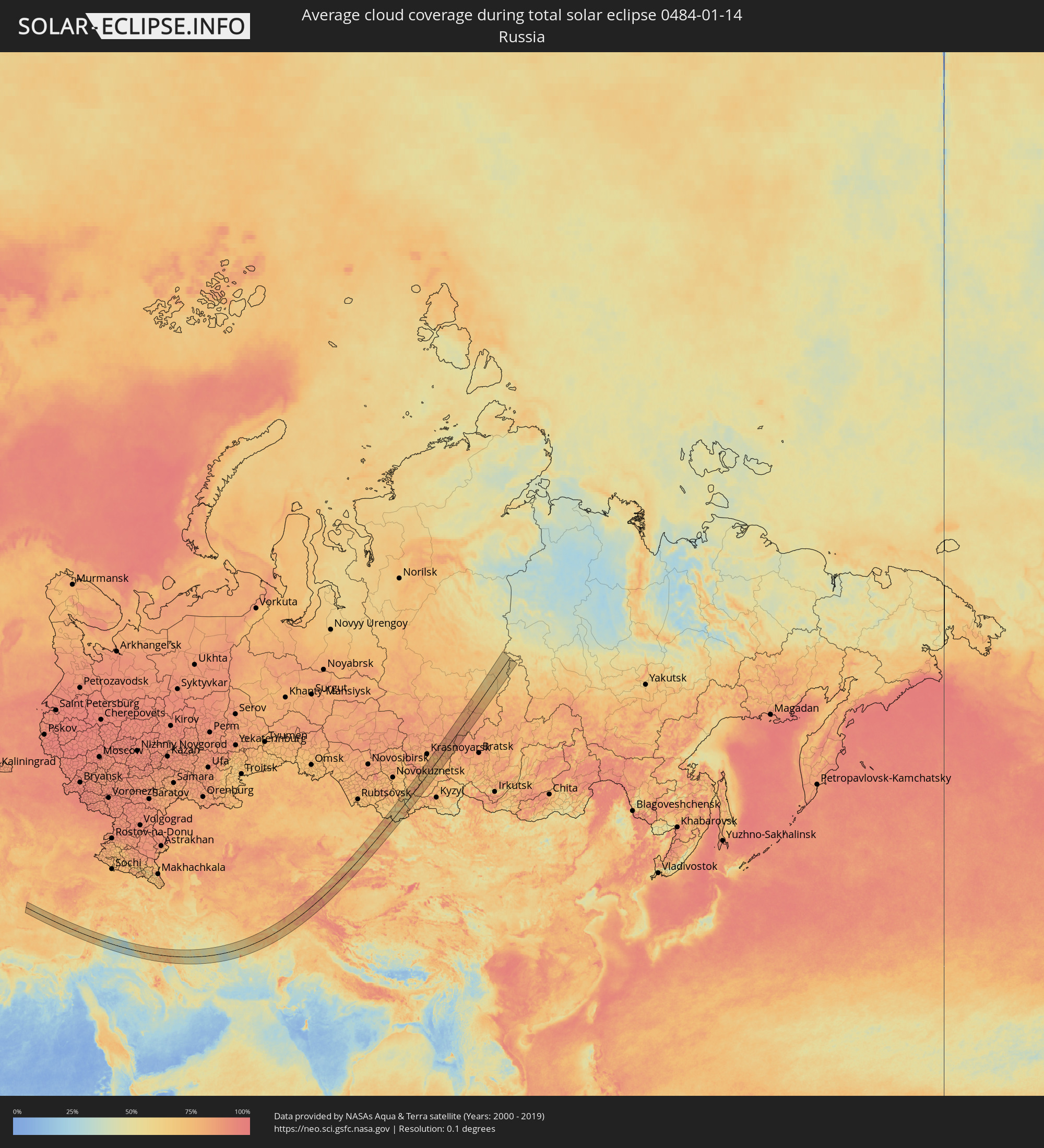 Russia
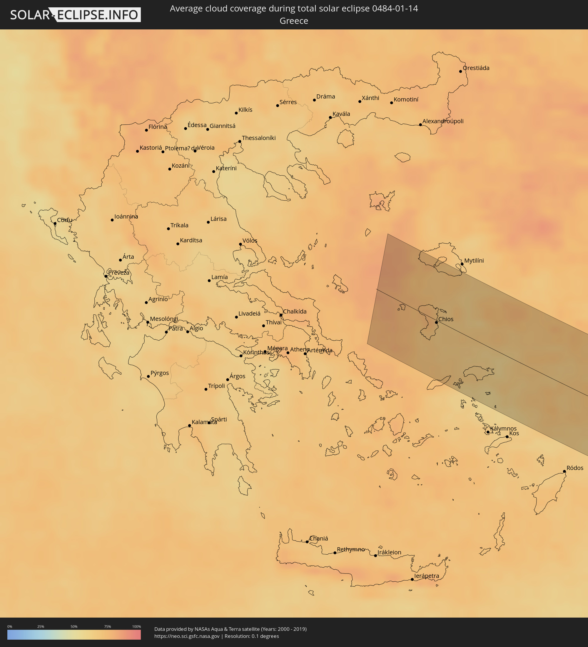 Greece
 Turkey
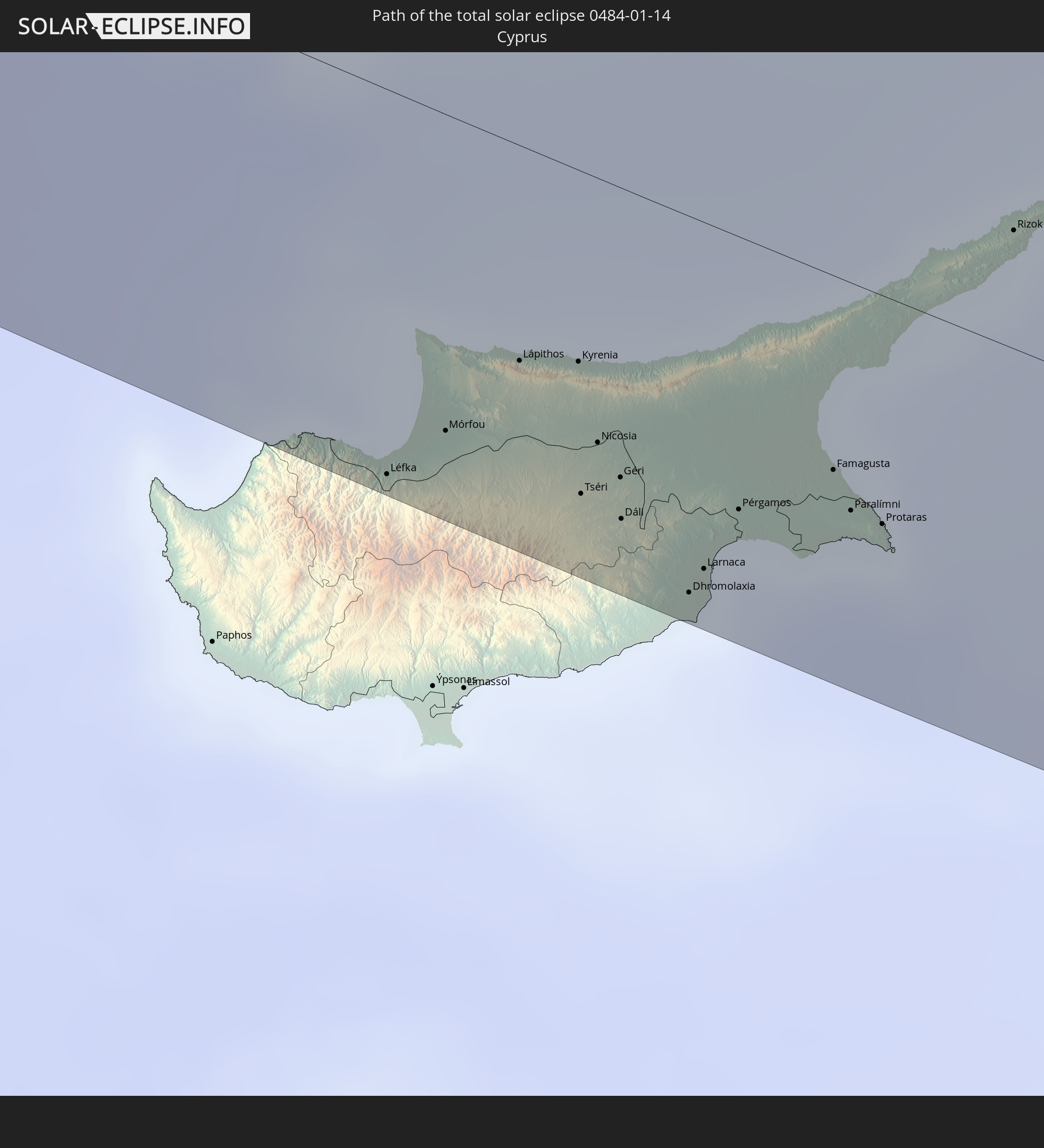
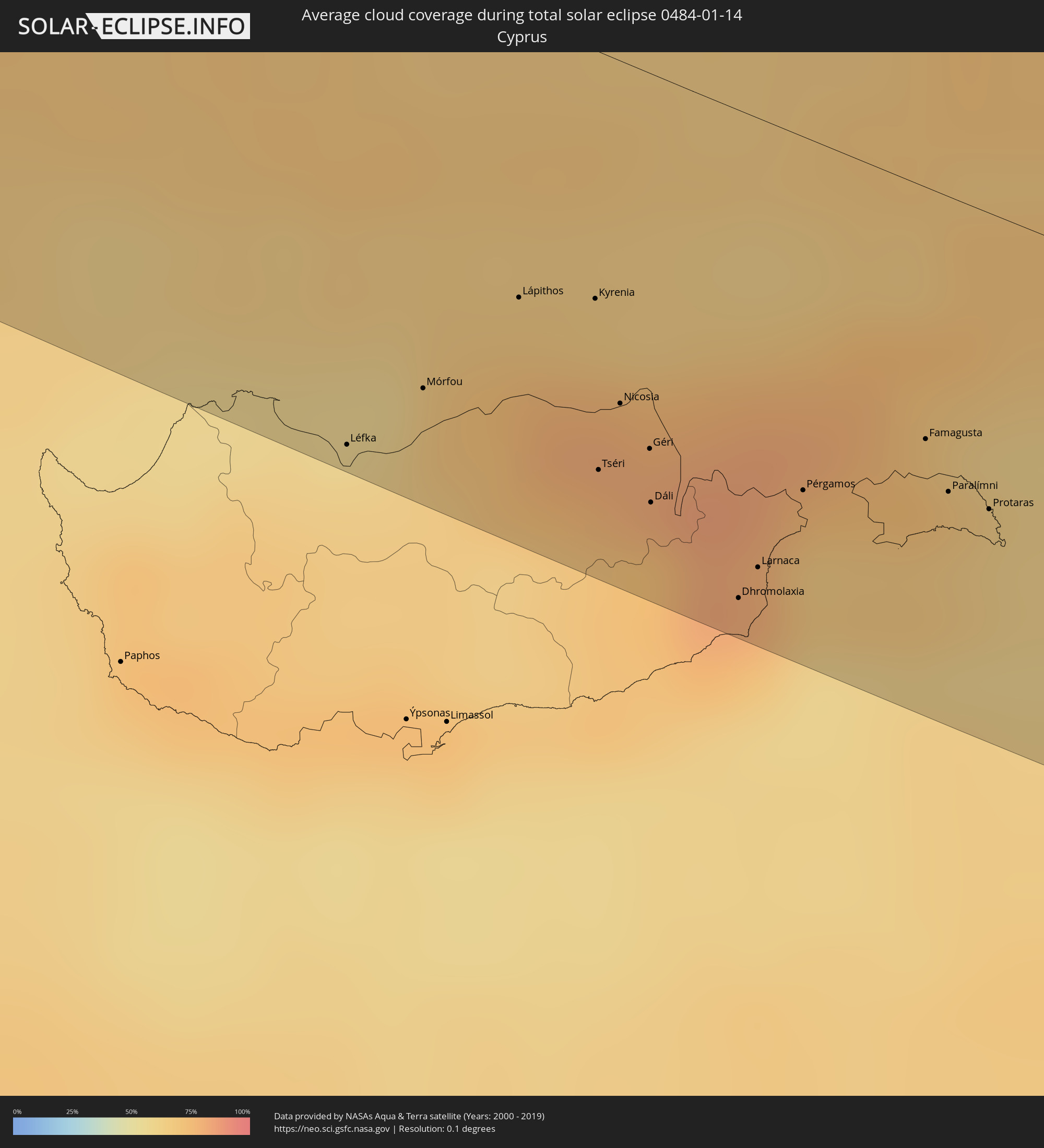 Cyprus
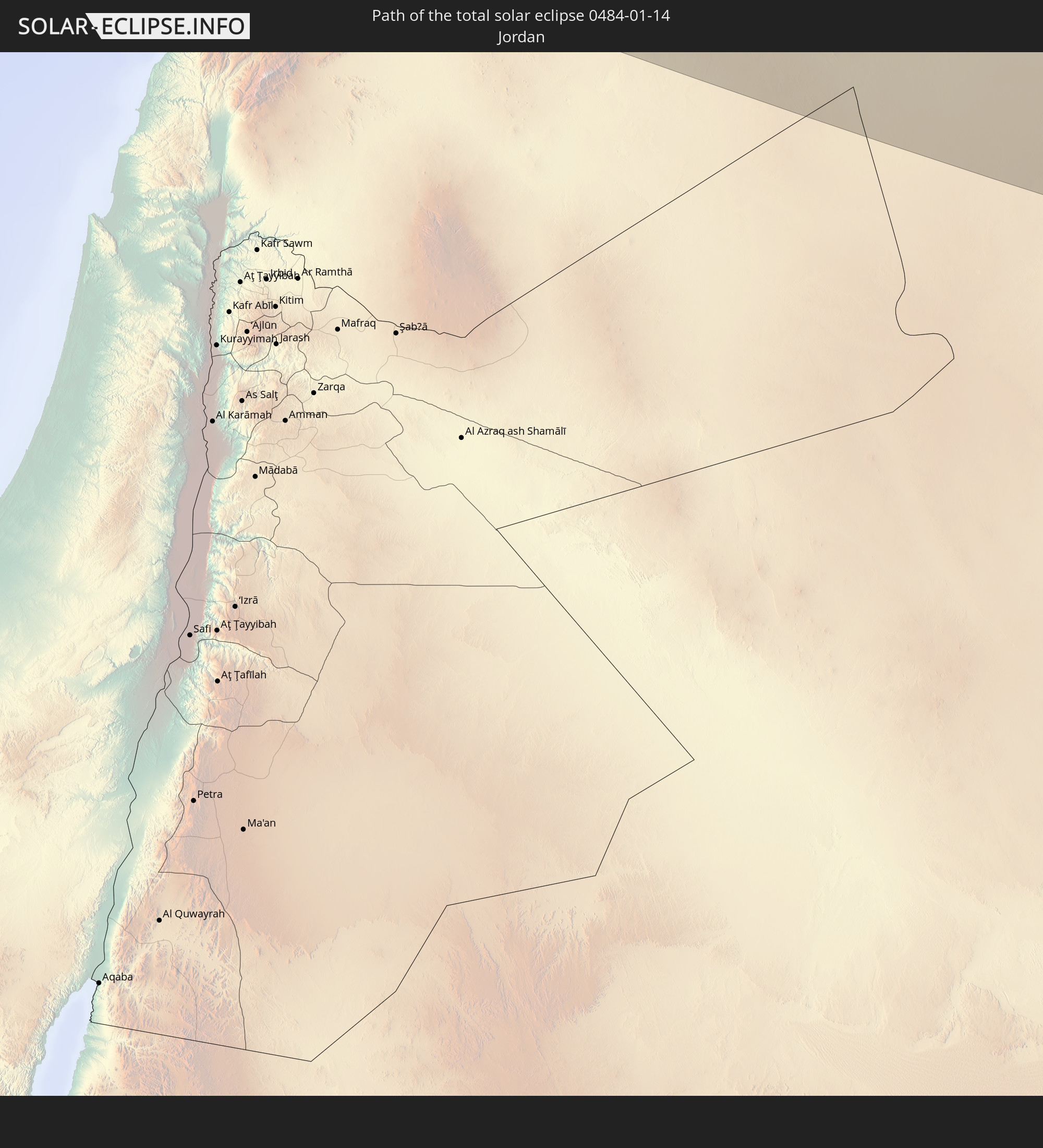
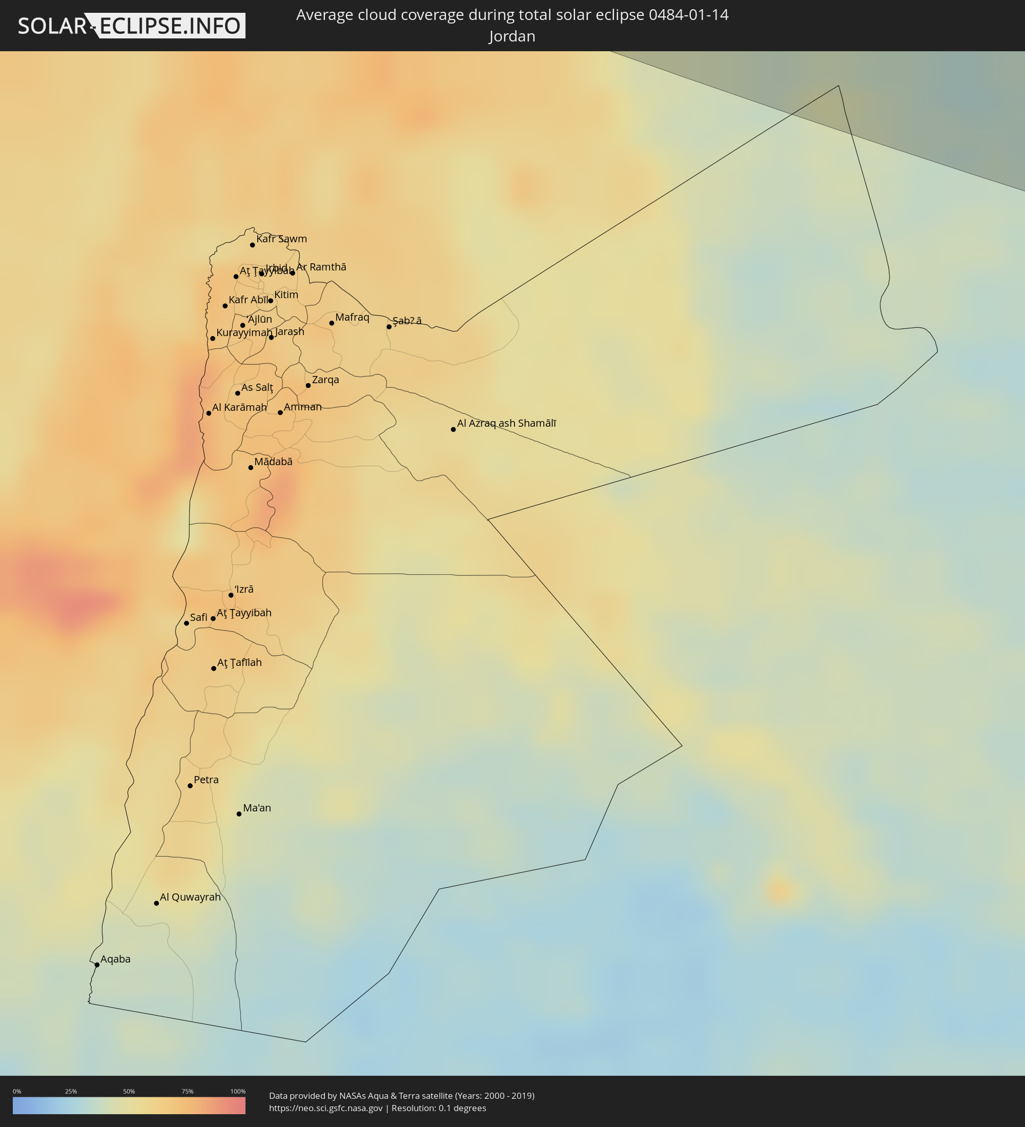 Jordan
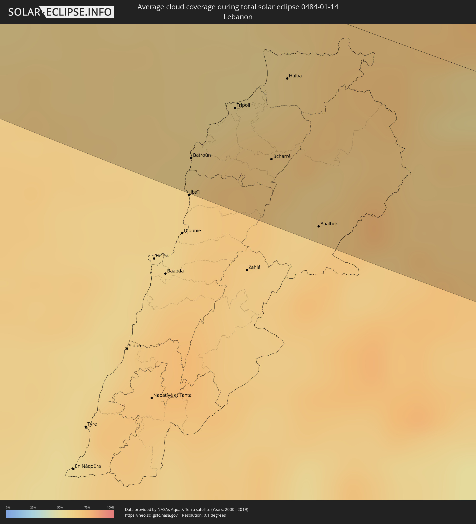 Lebanon
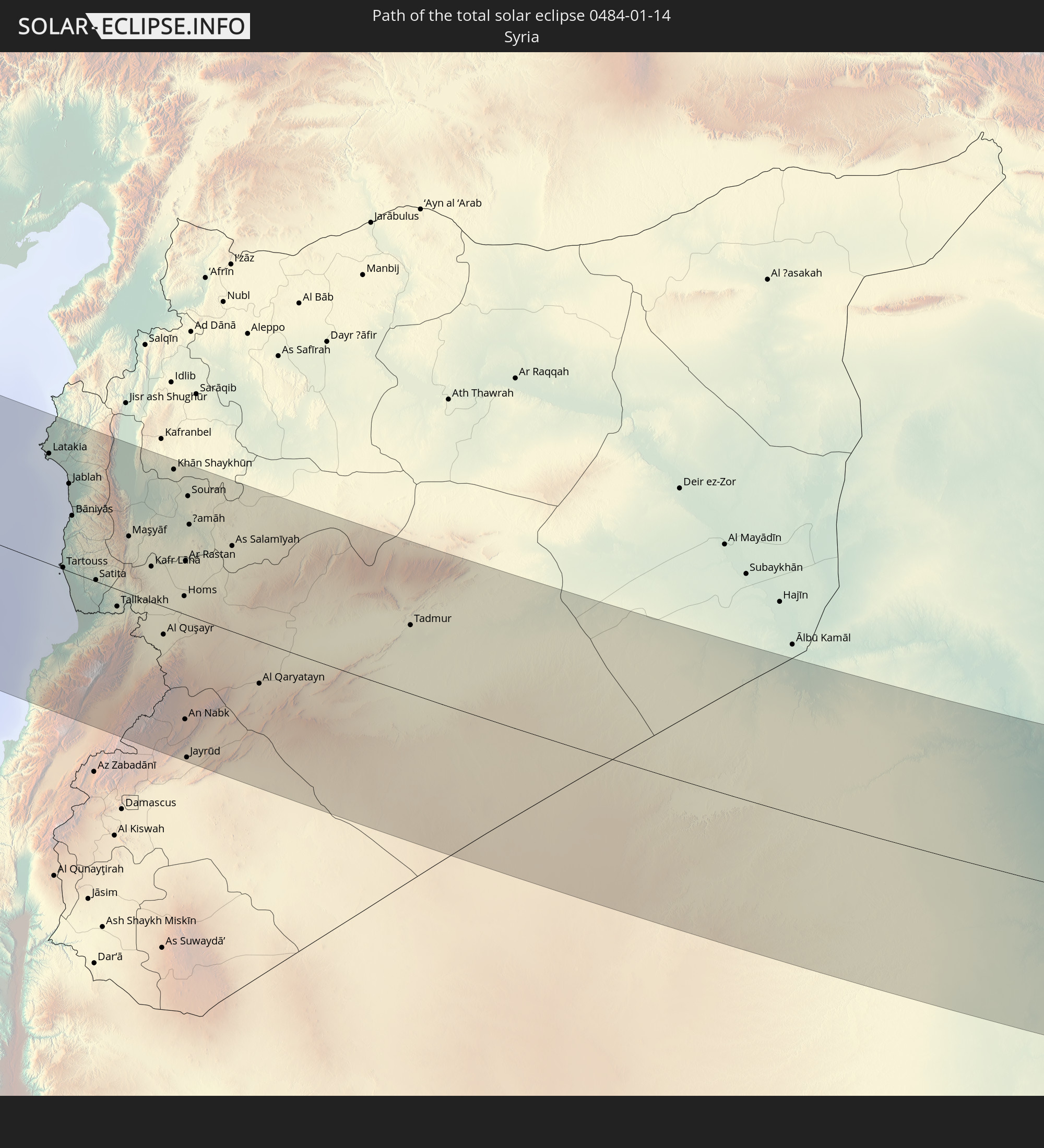
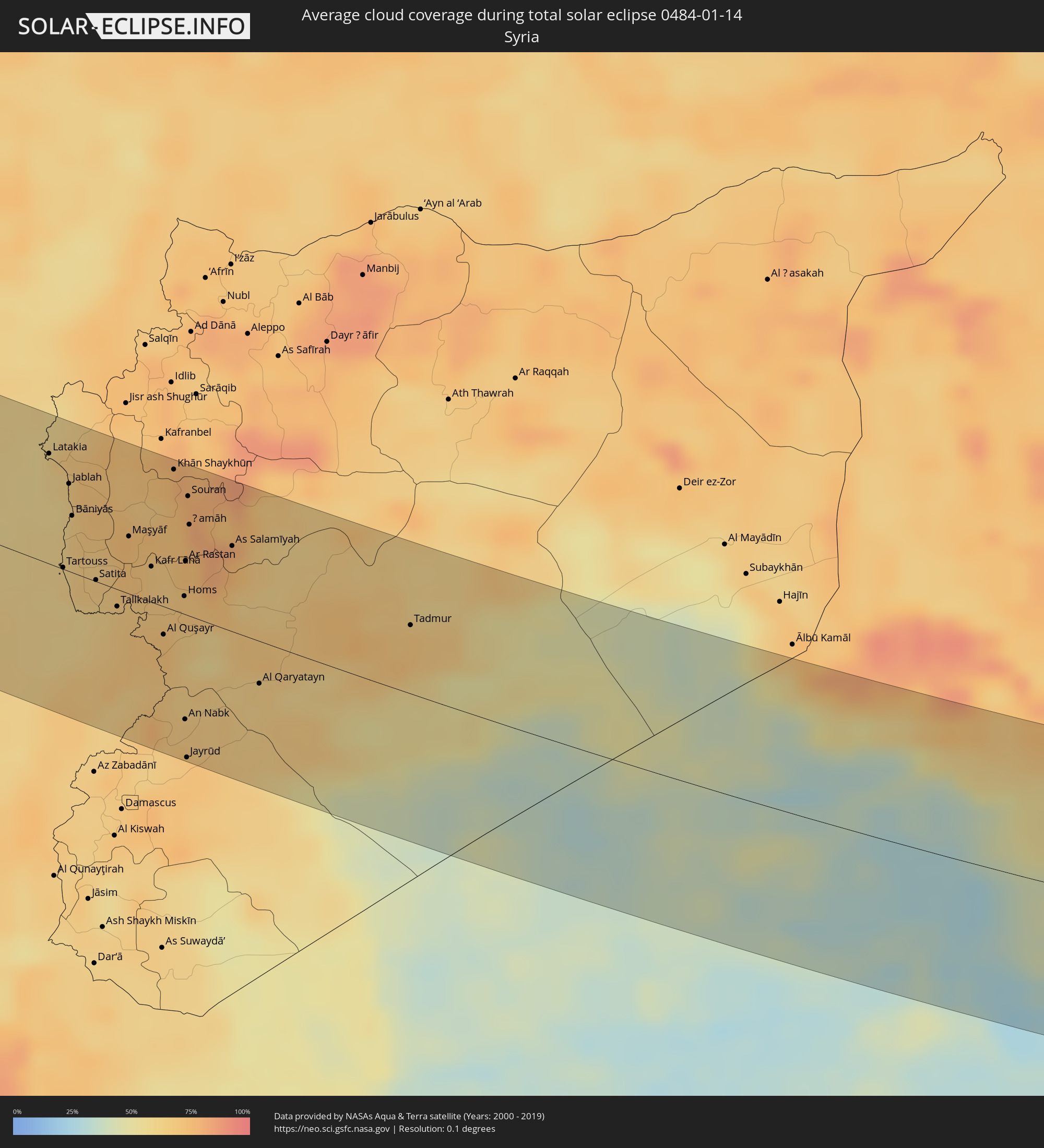 Syria
Syria
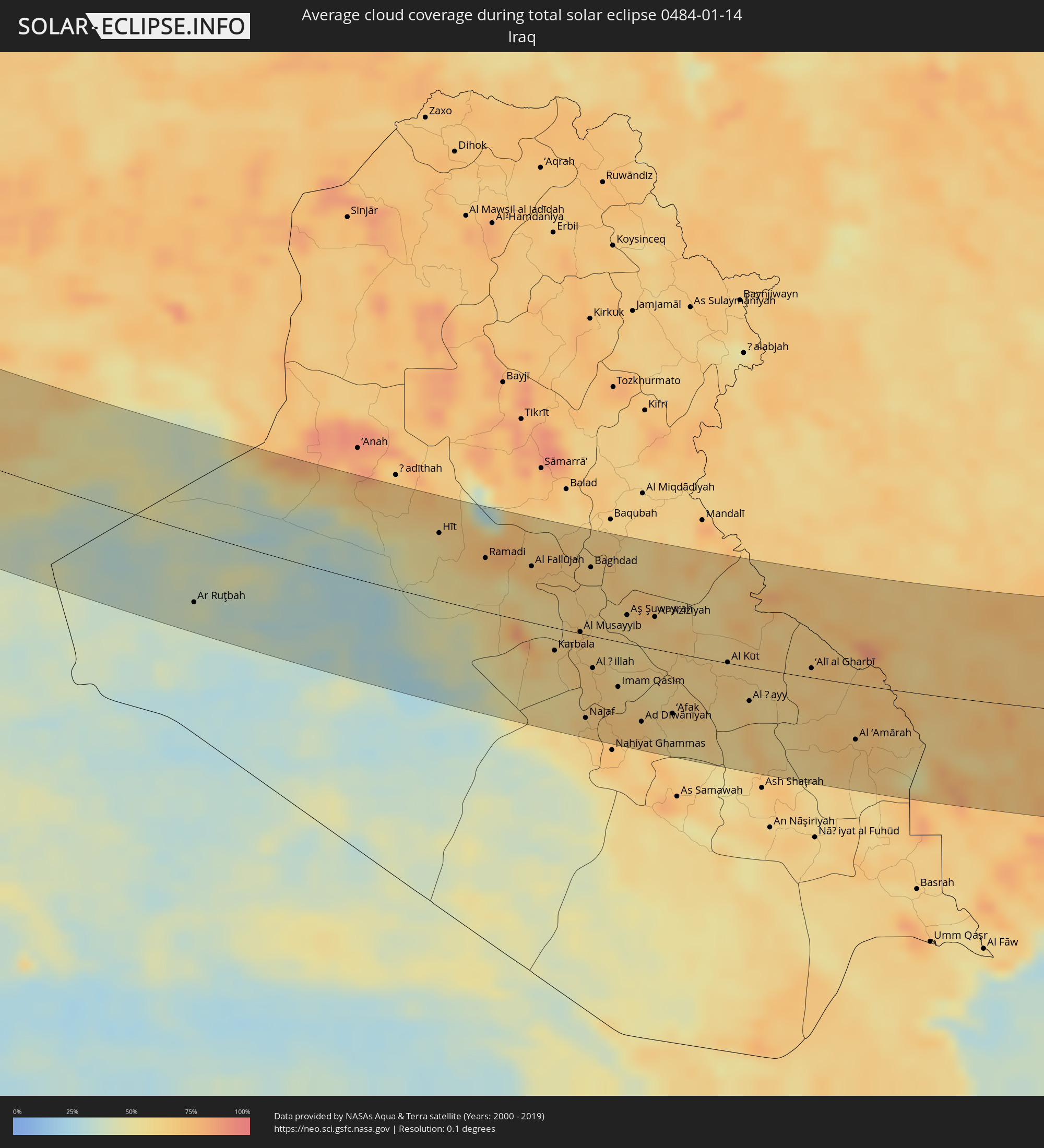 Iraq
Iraq
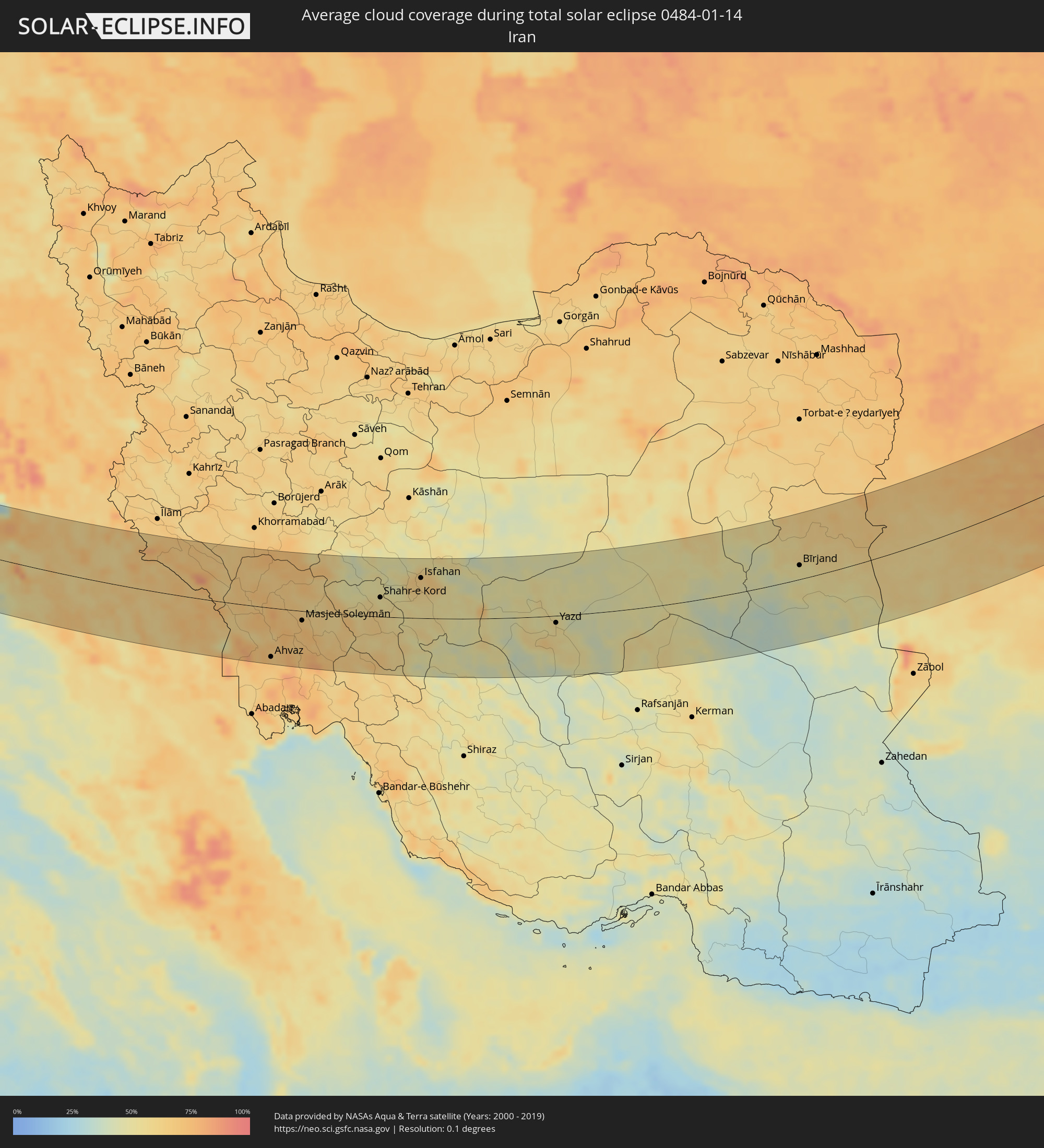 Iran
Iran
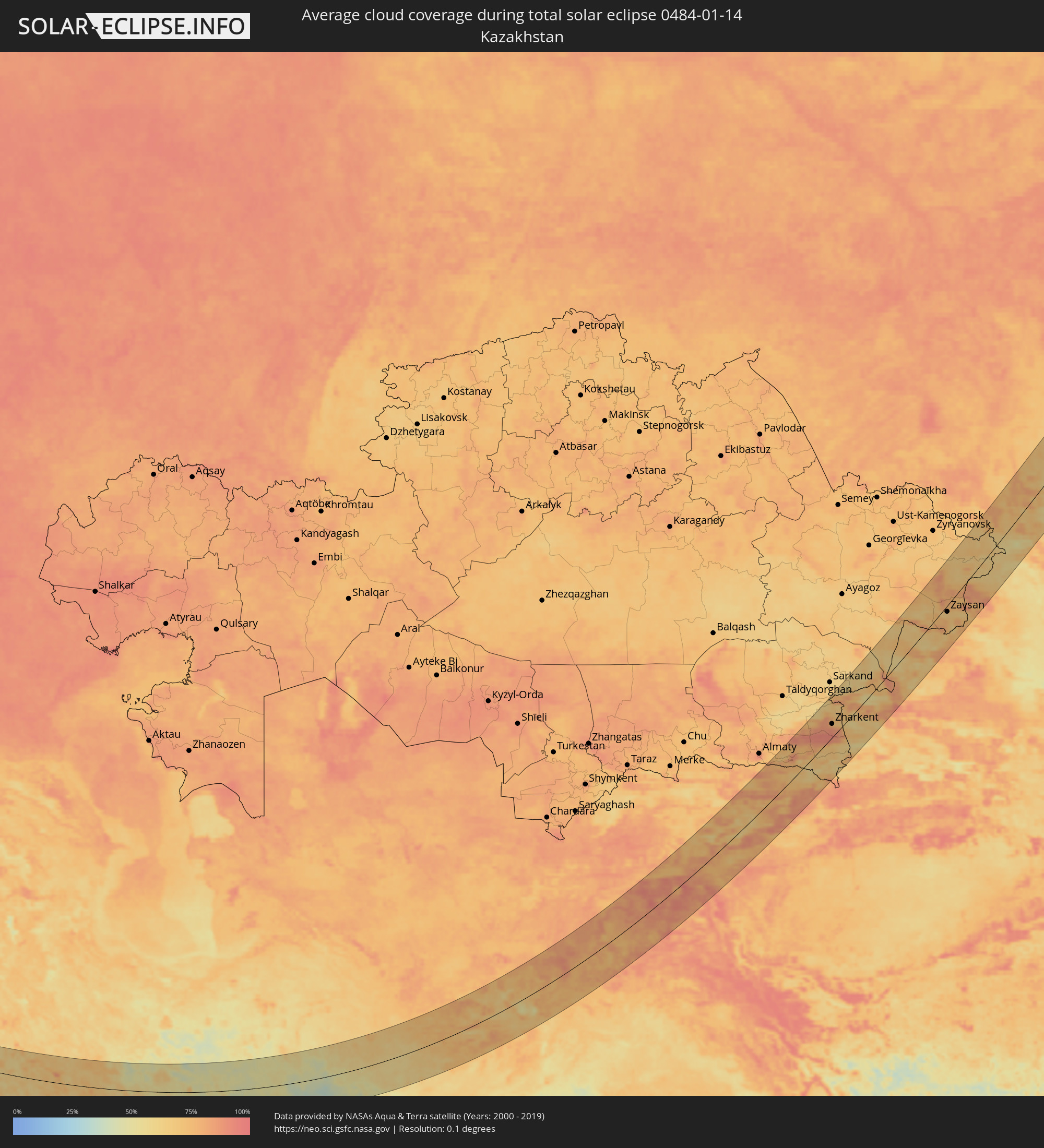 Kazakhstan
 Afghanistan
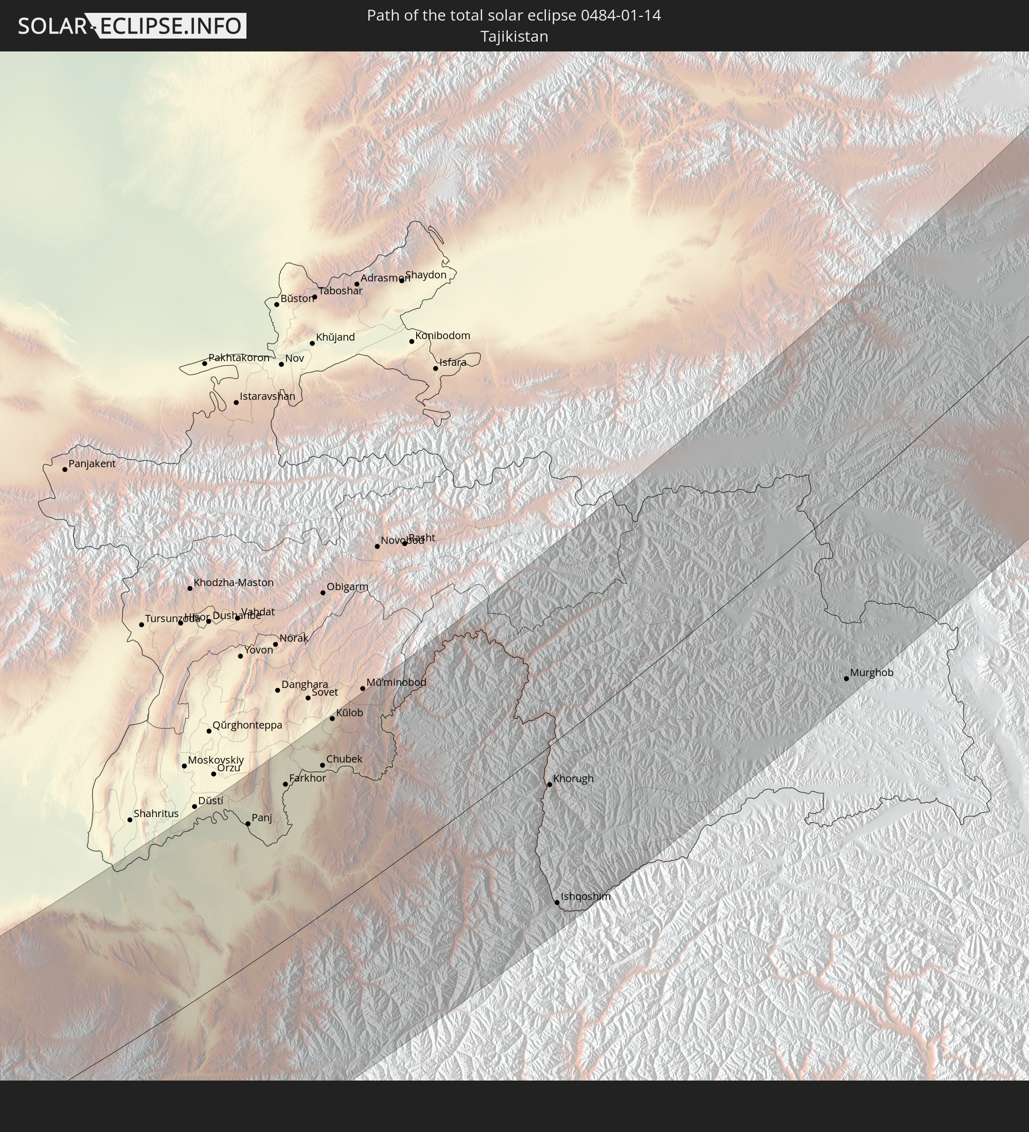
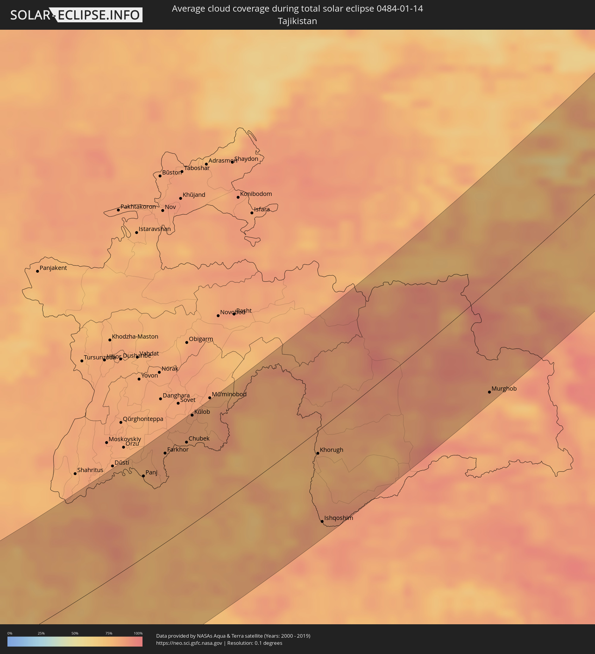 Tajikistan
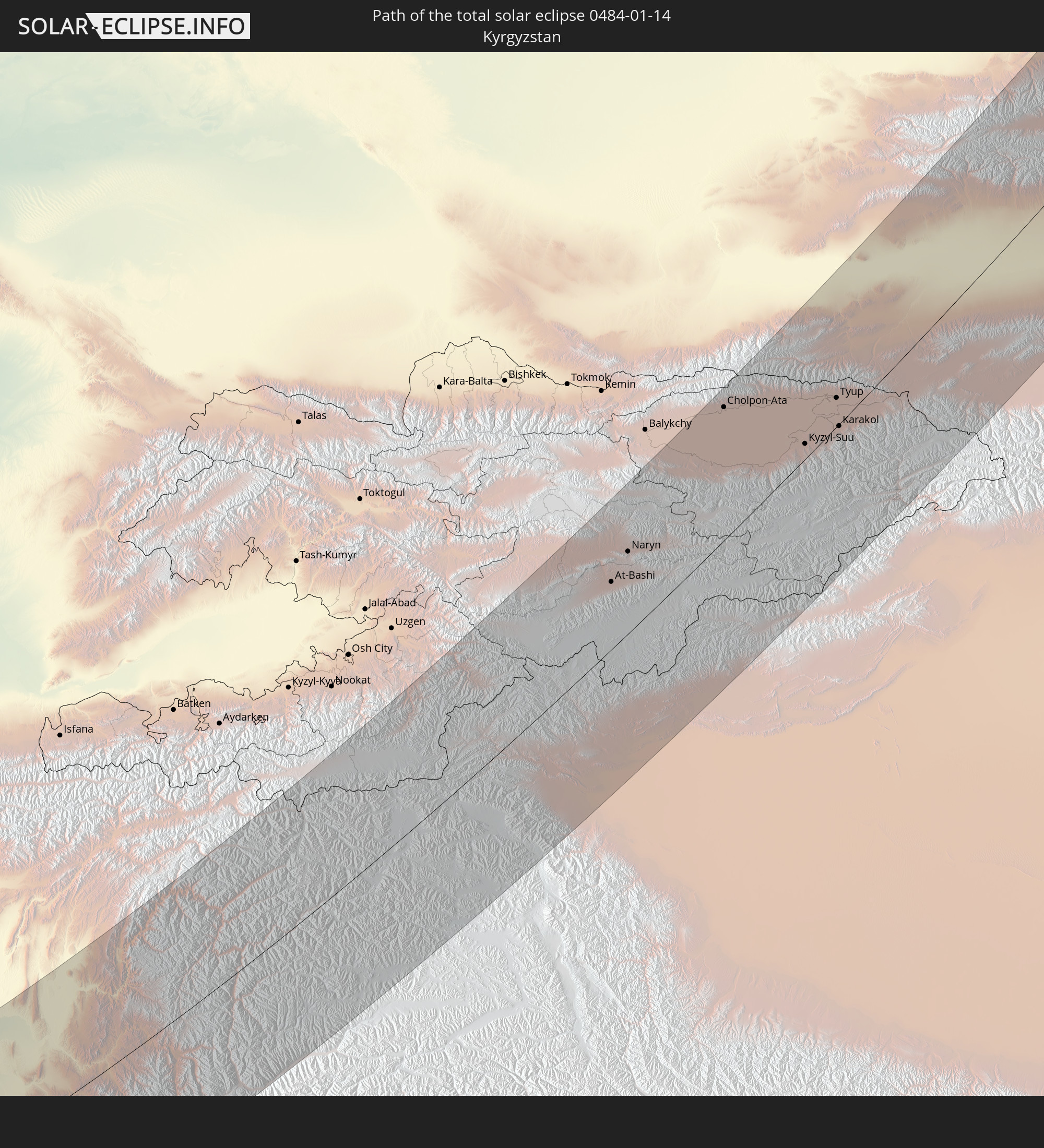
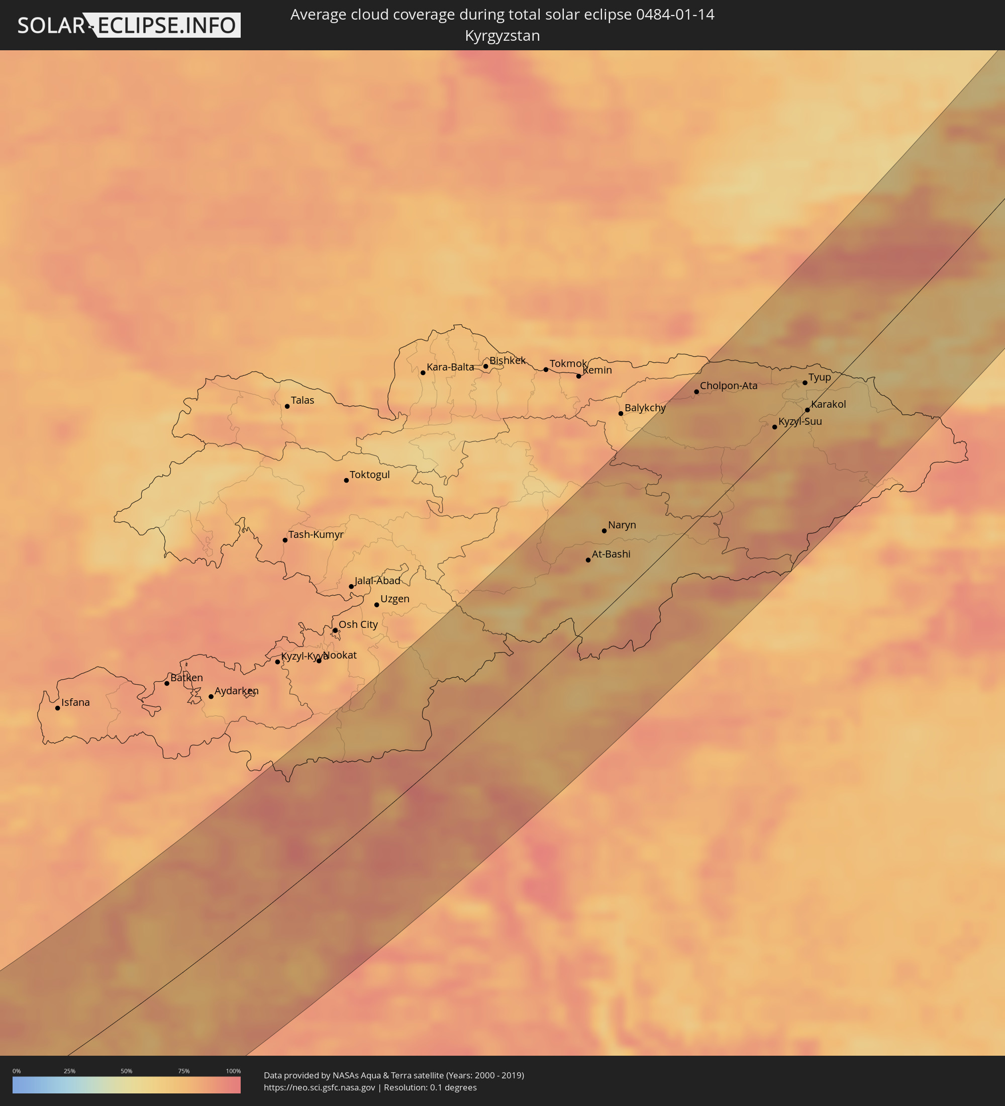 Kyrgyzstan
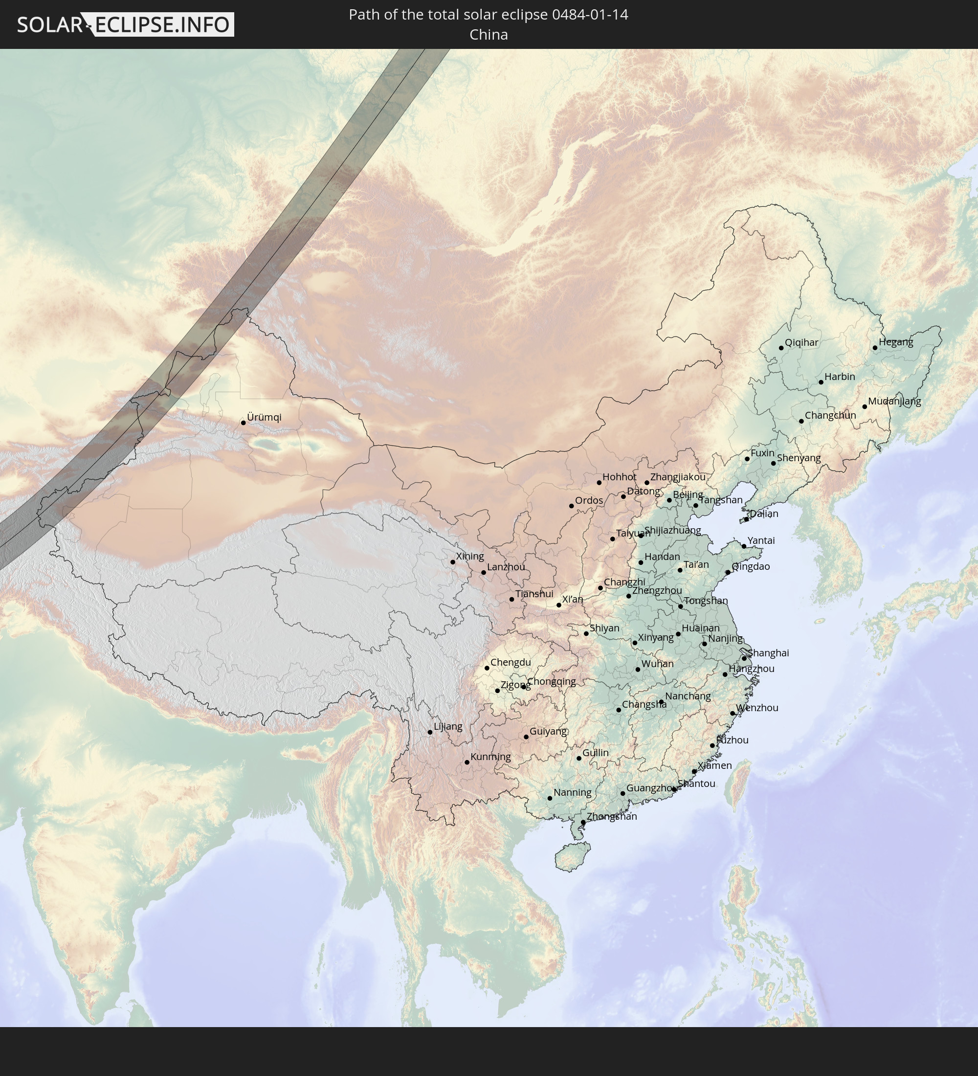
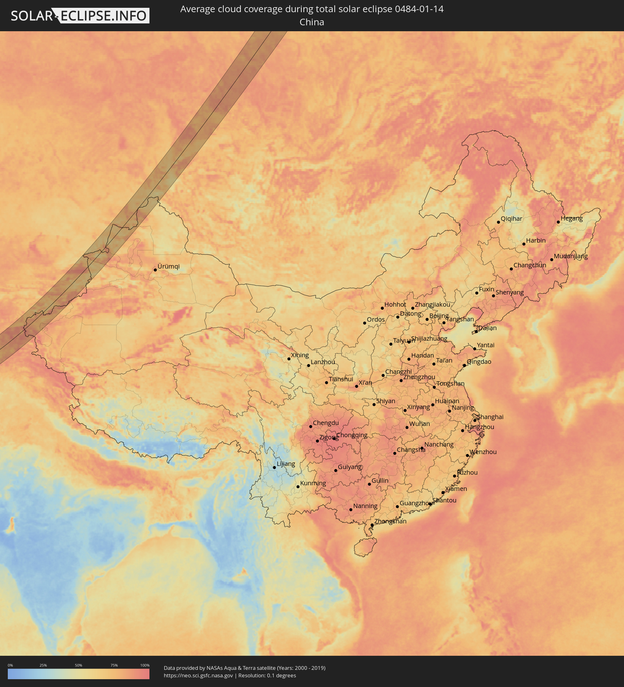 China
China
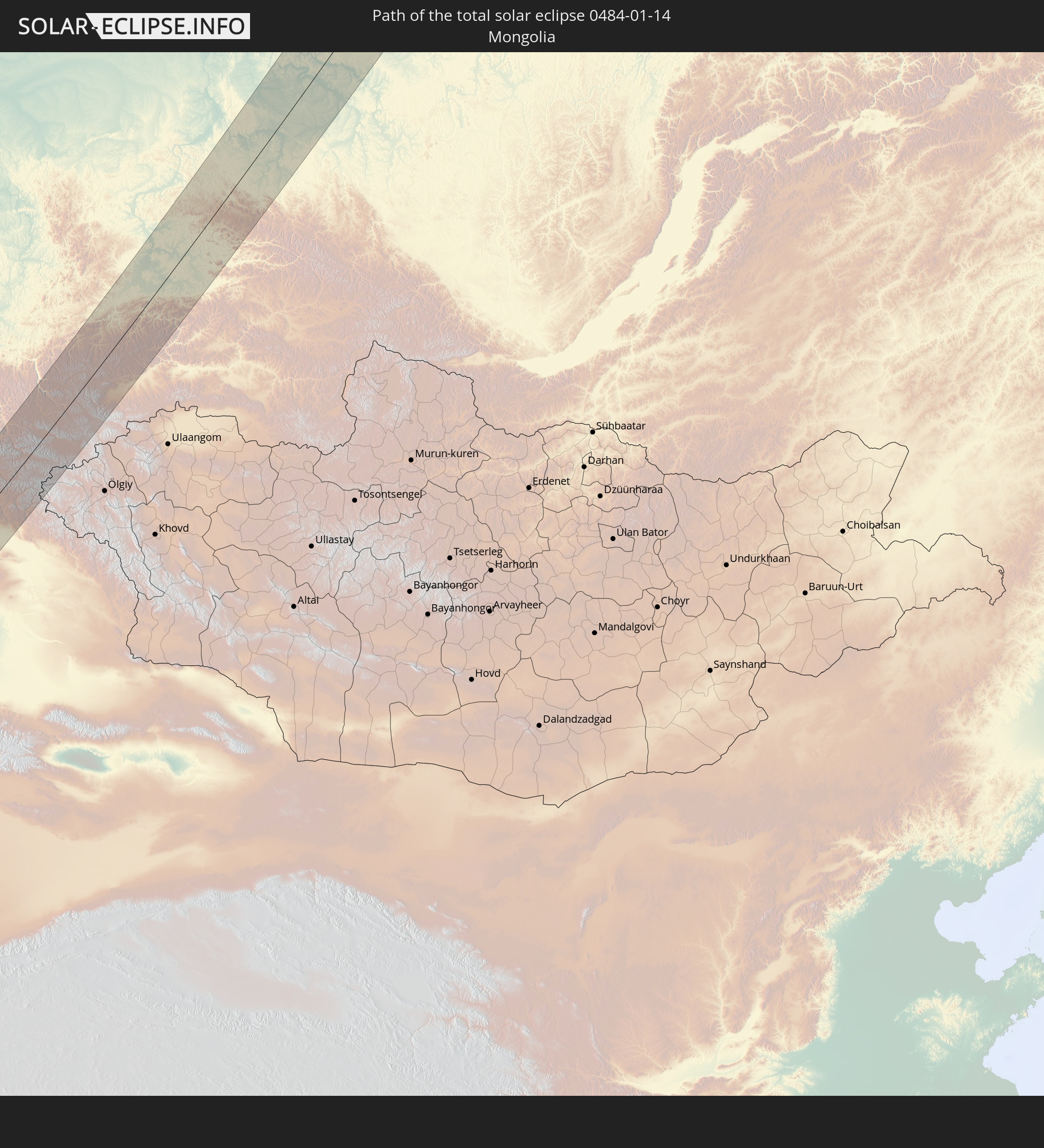
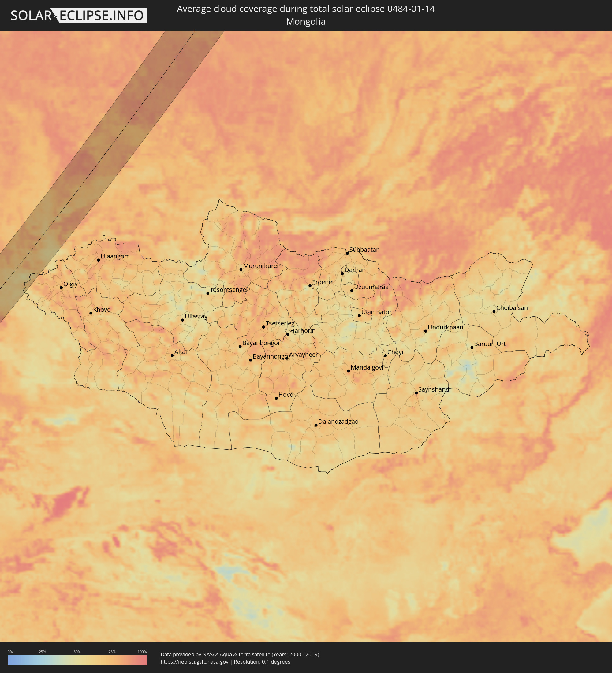 Mongolia
Cities inside the path of the eclipse
The following table shows all locations with a population of more than 5,000 inside the eclipse path. Cities which have more than 100,000 inhabitants are marked bold. A click at the locations opens a detailed map.
| City | Type | Eclipse duration | Local time of max. eclipse | Distance to central line | Ø Cloud coverage |
|
Vrontádos, North Aegean
|
total | - | 07:20:09 UTC+01:34 | 1 km | 73% |
|
Chios, North Aegean
|
total | - | 07:20:06 UTC+01:34 | 3 km | 73% |
|
Néon Karlovásion, North Aegean
|
total | - | 07:19:37 UTC+01:34 | 38 km | 68% |
|
Menemen, İzmir
|
total | - | 07:43:07 UTC+01:56 | 58 km | 74% |
|
İzmir, İzmir
|
total | - | 07:42:53 UTC+01:56 | 41 km | 70% |
|
Kuşadası, Aydın
|
total | - | 07:42:09 UTC+01:56 | 10 km | 63% |
|
Söke, Aydın
|
total | - | 07:42:06 UTC+01:56 | 14 km | 66% |
|
Manisa, Manisa
|
total | - | 07:43:22 UTC+01:56 | 72 km | 76% |
|
Turgutlu, Manisa
|
total | - | 07:43:23 UTC+01:56 | 72 km | 71% |
|
Aydın, Aydın
|
total | - | 07:42:32 UTC+01:56 | 12 km | 67% |
|
Ödemiş, İzmir
|
total | - | 07:43:11 UTC+01:56 | 55 km | 67% |
|
Nazilli, Aydın
|
total | - | 07:42:59 UTC+01:56 | 38 km | 66% |
|
Denizli, Denizli
|
total | - | 07:43:20 UTC+01:56 | 53 km | 72% |
|
Fethiye, Muğla
|
total | - | 07:41:43 UTC+01:56 | 59 km | 65% |
|
Antalya, Antalya
|
total | - | 07:43:20 UTC+01:56 | 27 km | 69% |
|
Belek, Antalya
|
total | - | 07:43:33 UTC+01:56 | 36 km | 68% |
|
Manavgat, Antalya
|
total | - | 07:43:46 UTC+01:56 | 42 km | 69% |
|
Alanya, Antalya
|
total | - | 07:43:53 UTC+01:56 | 38 km | 65% |
|
Anamur, Mersin
|
total | - | 07:43:57 UTC+01:56 | 20 km | 69% |
|
Léfka, Nicosia
|
total | - | 07:59:08 UTC+02:13 | 78 km | 63% |
|
Mórfou, Nicosia
|
total | - | 07:59:23 UTC+02:13 | 65 km | 69% |
|
Lápithos, Keryneia
|
total | - | 07:59:44 UTC+02:13 | 44 km | 77% |
|
Kyrenia, Keryneia
|
total | - | 07:59:52 UTC+02:13 | 39 km | 77% |
|
Tséri, Nicosia
|
total | - | 07:59:30 UTC+02:13 | 66 km | 77% |
|
Nicosia, Nicosia
|
total | - | 07:59:41 UTC+02:13 | 54 km | 79% |
|
Géri, Nicosia
|
total | - | 07:59:38 UTC+02:13 | 59 km | 80% |
|
Dáli, Nicosia
|
total | - | 07:59:31 UTC+02:13 | 68 km | 73% |
|
Dhromolaxia, Larnaka
|
total | - | 07:59:28 UTC+02:13 | 77 km | 69% |
|
Aradíppou, Larnaka
|
total | - | 07:59:35 UTC+02:13 | 69 km | 79% |
|
Larnaca, Larnaka
|
total | - | 07:59:34 UTC+02:13 | 71 km | 69% |
|
Livádia, Larnaka
|
total | - | 07:59:37 UTC+02:13 | 68 km | 79% |
|
Pérgamos, Larnaka
|
total | - | 07:59:49 UTC+02:13 | 56 km | 68% |
|
Famagusta, Ammochostos
|
total | - | 08:00:08 UTC+02:13 | 40 km | 74% |
|
Paralímni, Ammochostos
|
total | - | 08:00:04 UTC+02:13 | 47 km | 65% |
|
Protaras, Ammochostos
|
total | - | 08:00:06 UTC+02:13 | 47 km | 62% |
|
Batroûn, Liban-Nord
|
total | - | 07:47:08 UTC+02:00 | 73 km | 61% |
|
Latakia, Latakia
|
total | - | 08:14:17 UTC+02:25 | 65 km | 60% |
|
Tripoli, Liban-Nord
|
total | - | 07:47:35 UTC+02:00 | 47 km | 62% |
|
Tartouss, Tartus
|
total | - | 08:13:28 UTC+02:25 | 1 km | 62% |
|
Jablah, Latakia
|
total | - | 08:14:10 UTC+02:25 | 51 km | 60% |
|
Bāniyās, Tartus
|
total | - | 08:13:56 UTC+02:25 | 33 km | 61% |
|
Bcharré, Liban-Nord
|
total | - | 07:47:30 UTC+02:00 | 62 km | 67% |
|
Halba, Aakkâr
|
total | - | 07:47:58 UTC+02:00 | 29 km | 64% |
|
Baalbek, Baalbek-Hermel
|
total | - | 07:47:22 UTC+02:00 | 81 km | 64% |
|
Maşyāf, Hama
|
total | - | 08:14:11 UTC+02:25 | 34 km | 74% |
|
Al Quşayr, Homs
|
total | - | 08:13:39 UTC+02:25 | 17 km | 71% |
|
Khān Shaykhūn, Idlib
|
total | - | 08:15:03 UTC+02:25 | 83 km | 75% |
|
Homs, Homs
|
total | - | 08:14:06 UTC+02:25 | 11 km | 69% |
|
An Nabk, Rif-dimashq
|
total | - | 08:13:08 UTC+02:25 | 63 km | 71% |
|
Ar Rastan, Homs
|
total | - | 08:14:24 UTC+02:25 | 32 km | 69% |
|
Jayrūd, Rif-dimashq
|
total | - | 08:12:50 UTC+02:25 | 85 km | 70% |
|
Souran, Hama
|
total | - | 08:14:56 UTC+02:25 | 70 km | 74% |
|
Ḩamāh, Hama
|
total | - | 08:14:43 UTC+02:25 | 54 km | 77% |
|
As Salamīyah, Hama
|
total | - | 08:14:52 UTC+02:25 | 51 km | 73% |
|
Al Qaryatayn, Homs
|
total | - | 08:13:58 UTC+02:25 | 25 km | 62% |
|
Tadmur, Homs
|
total | - | 08:15:36 UTC+02:25 | 41 km | 69% |
|
Ramadi, Anbar
|
total | - | 08:52:42 UTC+02:57 | 50 km | 65% |
|
Al Fallūjah, Anbar
|
total | - | 08:53:15 UTC+02:57 | 53 km | 69% |
|
Karbala, Karbalāʼ
|
total | - | 08:52:35 UTC+02:57 | 22 km | 58% |
|
Abū Ghurayb, Mayorality of Baghdad
|
total | - | 08:53:45 UTC+02:57 | 57 km | 68% |
|
Al Hindīyah, Karbalāʼ
|
total | - | 08:52:47 UTC+02:57 | 25 km | 66% |
|
Al Musayyib, Bābil
|
total | - | 08:53:11 UTC+02:57 | 1 km | 66% |
|
Najaf, An Najaf
|
total | - | 08:52:14 UTC+02:57 | 79 km | 65% |
|
Baghdad, Mayorality of Baghdad
|
total | - | 08:54:07 UTC+02:57 | 65 km | 62% |
|
Al Ḩillah, Bābil
|
total | - | 08:52:56 UTC+02:57 | 30 km | 67% |
|
Kufa, An Najaf
|
total | - | 08:52:25 UTC+02:57 | 75 km | 66% |
|
Ash Shāmīyah, Al Qādisīyah
|
total | - | 08:52:31 UTC+02:57 | 81 km | 70% |
|
Ad Dīwānīyah, Al Qādisīyah
|
total | - | 08:53:02 UTC+02:57 | 72 km | 69% |
|
Al ‘Azīzīyah, Wāsiţ
|
total | - | 08:54:29 UTC+02:57 | 31 km | 64% |
|
Al Kūt, Wāsiţ
|
total | - | 08:55:03 UTC+02:57 | 1 km | 69% |
|
Al Ḩayy, Wāsiţ
|
total | - | 08:54:56 UTC+02:57 | 33 km | 65% |
|
Al ‘Amārah, Maysan
|
total | - | 08:56:10 UTC+02:57 | 53 km | 68% |
|
Dehlorān, Īlām
|
total | - | 09:25:39 UTC+03:25 | 43 km | 86% |
|
Sūsangerd, Khuzestan
|
total | - | 09:25:36 UTC+03:25 | 70 km | 76% |
|
Shūsh, Khuzestan
|
total | - | 09:26:31 UTC+03:25 | 0 km | 67% |
|
Ahvaz, Khuzestan
|
total | - | 09:26:04 UTC+03:25 | 92 km | 70% |
|
Shūshtar, Khuzestan
|
total | - | 09:27:19 UTC+03:25 | 9 km | 70% |
|
Masjed Soleymān, Khuzestan
|
total | - | 09:27:55 UTC+03:25 | 18 km | 73% |
|
Shahr-e Kord, Chahār Maḩāll va Bakhtīārī
|
total | - | 09:31:05 UTC+03:25 | 36 km | 52% |
|
Borūjen, Chahār Maḩāll va Bakhtīārī
|
total | - | 09:31:21 UTC+03:25 | 2 km | 52% |
|
Najafābād, Isfahan
|
total | - | 09:32:22 UTC+03:25 | 72 km | 63% |
|
Falāvarjān, Isfahan
|
total | - | 09:32:31 UTC+03:25 | 64 km | 64% |
|
Isfahan, Isfahan
|
total | - | 09:32:56 UTC+03:25 | 75 km | 65% |
|
Shāhreẕā, Isfahan
|
total | - | 09:32:29 UTC+03:25 | 7 km | 56% |
|
Ābādeh, Fars
|
total | - | 09:32:44 UTC+03:25 | 90 km | 45% |
|
Ardakān, Yazd
|
total | - | 09:36:44 UTC+03:25 | 34 km | 55% |
|
Yazd, Yazd
|
total | - | 09:36:52 UTC+03:25 | 13 km | 55% |
|
Bīrjand, Khorāsān-e Jonūbī
|
total | - | 09:47:36 UTC+03:25 | 25 km | 52% |
|
Farah, Farah
|
total | - | 10:27:18 UTC+04:00 | 104 km | 61% |
|
Shīnḏanḏ, Herat
|
total | - | 10:28:26 UTC+04:00 | 7 km | 59% |
|
Herāt, Herat
|
total | - | 10:29:44 UTC+04:00 | 100 km | 71% |
|
Khulm, Balkh
|
total | - | 10:43:35 UTC+04:00 | 104 km | 79% |
|
Bāmyān, Bamyan
|
total | - | 10:42:04 UTC+04:00 | 80 km | 72% |
|
Aībak, Samangan
|
total | - | 10:43:50 UTC+04:00 | 48 km | 78% |
|
Baghlān, Baghlan
|
total | - | 10:45:09 UTC+04:00 | 2 km | 83% |
|
Pul-e Khumrī, Baghlan
|
total | - | 10:45:00 UTC+04:00 | 16 km | 78% |
|
Qarāwul, Kunduz
|
total | - | 10:46:17 UTC+04:00 | 98 km | 81% |
|
Kunduz, Kunduz
|
total | - | 10:46:00 UTC+04:00 | 50 km | 81% |
|
Panj, Khatlon
|
total | - | 11:22:09 UTC+04:35 | 84 km | 77% |
|
Khanabad, Kunduz
|
total | - | 10:46:30 UTC+04:00 | 32 km | 79% |
|
Nahrīn, Baghlan
|
total | - | 10:45:58 UTC+04:00 | 26 km | 73% |
|
Farkhor, Khatlon
|
total | - | 11:23:00 UTC+04:35 | 91 km | 82% |
|
Ārt Khwājah, Takhar
|
total | - | 10:47:36 UTC+04:00 | 51 km | 80% |
|
Taloqan, Takhar
|
total | - | 10:47:24 UTC+04:00 | 16 km | 75% |
|
Vose’, Khatlon
|
total | - | 11:23:45 UTC+04:35 | 107 km | 83% |
|
Chubek, Khatlon
|
total | - | 11:23:43 UTC+04:35 | 87 km | 81% |
|
Kŭlob, Khatlon
|
total | - | 11:24:08 UTC+04:35 | 109 km | 82% |
|
Rustāq, Takhar
|
total | - | 10:48:21 UTC+04:00 | 36 km | 76% |
|
Fayzabad, Badakhshan
|
total | - | 10:49:52 UTC+04:00 | 4 km | 82% |
|
Khorugh, Gorno-Badakhshan
|
total | - | 11:27:21 UTC+04:35 | 22 km | 80% |
|
Ishqoshim, Gorno-Badakhshan
|
total | - | 11:26:52 UTC+04:35 | 93 km | 80% |
|
Murghob, Gorno-Badakhshan
|
total | - | 11:32:41 UTC+04:35 | 96 km | 78% |
|
At-Bashi, Naryn
|
total | - | 12:01:16 UTC+04:58 | 47 km | 69% |
|
Kashgar, Xinjiang Uyghur Autonomous Region
|
total | - | 15:02:15 UTC+08:00 | 102 km | 85% |
|
Naryn, Naryn
|
total | - | 12:01:45 UTC+04:58 | 56 km | 70% |
|
Cholpon-Ata, Issyk-Kul Region
|
total | - | 12:04:19 UTC+04:58 | 88 km | 77% |
|
Kyzyl-Suu, Issyk-Kul Region
|
total | - | 12:05:49 UTC+04:58 | 10 km | 77% |
|
Tyup, Issyk-Kul Region
|
total | - | 12:06:37 UTC+04:58 | 19 km | 65% |
|
Karakol, Issyk-Kul Region
|
total | - | 12:06:34 UTC+04:58 | 1 km | 71% |
|
Ak-Suu, Issyk-Kul Region
|
total | - | 12:06:48 UTC+04:58 | 9 km | 69% |
|
Kegen, Almaty Oblysy
|
total | - | 11:31:41 UTC+04:21 | 9 km | 66% |
|
Zharkent, Almaty Oblysy
|
total | - | 11:33:24 UTC+04:21 | 31 km | 84% |
|
Tūghyl, East Kazakhstan
|
total | - | 11:40:37 UTC+04:21 | 44 km | 68% |
|
Zaysan, East Kazakhstan
|
total | - | 11:41:34 UTC+04:21 | 13 km | 66% |
|
Abaza, Khakasiya
|
total | - | 13:37:25 UTC+06:11 | 53 km | 80% |
|
Ak-Dovurak, Tyva
|
total | - | 13:38:24 UTC+06:11 | 75 km | 78% |
|
Chernogorsk, Khakasiya
|
total | - | 13:38:27 UTC+06:11 | 67 km | 91% |
|
Sayanogorsk, Khakasiya
|
total | - | 13:38:49 UTC+06:11 | 12 km | 83% |
|
Abakan, Khakasiya
|
total | - | 13:38:39 UTC+06:11 | 52 km | 89% |
|
Minusinsk, Krasnoyarskiy
|
total | - | 13:38:56 UTC+06:11 | 38 km | 84% |
|
Shushenskoye, Krasnoyarskiy
|
total | - | 13:39:21 UTC+06:11 | 1 km | 84% |
|
Kuragino, Krasnoyarskiy
|
total | - | 13:39:58 UTC+06:11 | 3 km | 79% |
|
Uyar, Krasnoyarskiy
|
total | - | 13:40:54 UTC+06:11 | 39 km | 83% |
|
Zelenogorsk, Krasnoyarskiy
|
total | - | 13:41:02 UTC+06:11 | 45 km | 87% |
|
Borodino, Krasnoyarskiy
|
total | - | 13:41:26 UTC+06:11 | 16 km | 83% |
|
Kansk, Krasnoyarskiy
|
total | - | 13:42:05 UTC+06:11 | 5 km | 86% |
|
Ilanskiy, Krasnoyarskiy
|
total | - | 13:42:24 UTC+06:11 | 21 km | 86% |
|
Aban, Krasnoyarskiy
|
total | - | 13:42:10 UTC+06:11 | 8 km | 83% |
|
Boguchany, Krasnoyarskiy
|
total | - | 13:42:29 UTC+06:11 | 50 km | 80% |
|
Kodinsk, Krasnoyarskiy
|
total | - | 13:43:47 UTC+06:11 | 12 km | 80% |