Total solar eclipse of 10/23/0515
| Day of week: | Wednesday |
| Maximum duration of eclipse: | 03m04s |
| Maximum width of eclipse path: | 118 km |
| Saros cycle: | 90 |
| Coverage: | 100% |
| Magnitude: | 1.0351 |
| Gamma: | -0.0076 |
Wo kann man die Sonnenfinsternis vom 10/23/0515 sehen?
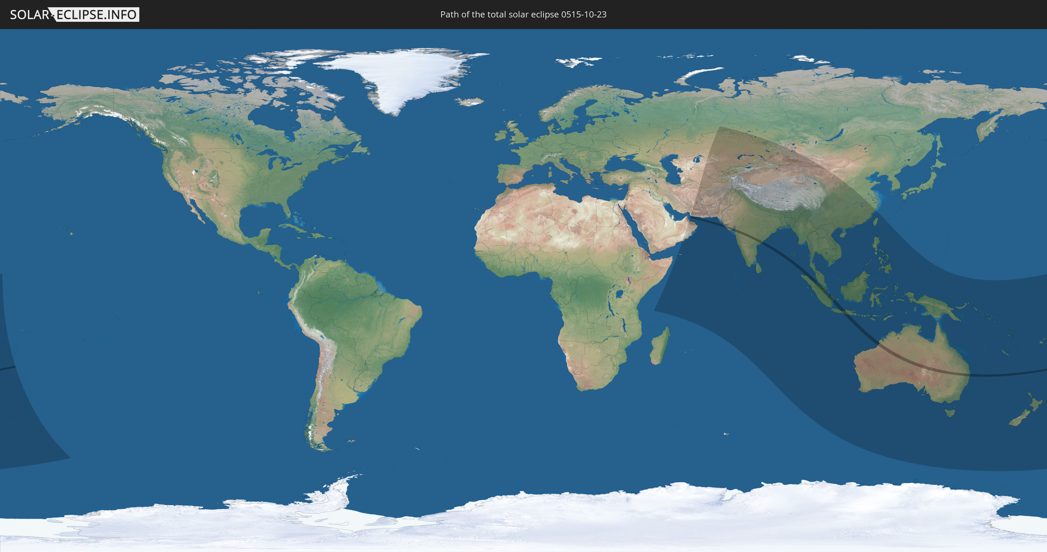
Die Sonnenfinsternis am 10/23/0515 kann man in 53 Ländern als partielle Sonnenfinsternis beobachten.
Der Finsternispfad verläuft durch 4 Länder. Nur in diesen Ländern ist sie als total Sonnenfinsternis zu sehen.
In den folgenden Ländern ist die Sonnenfinsternis total zu sehen
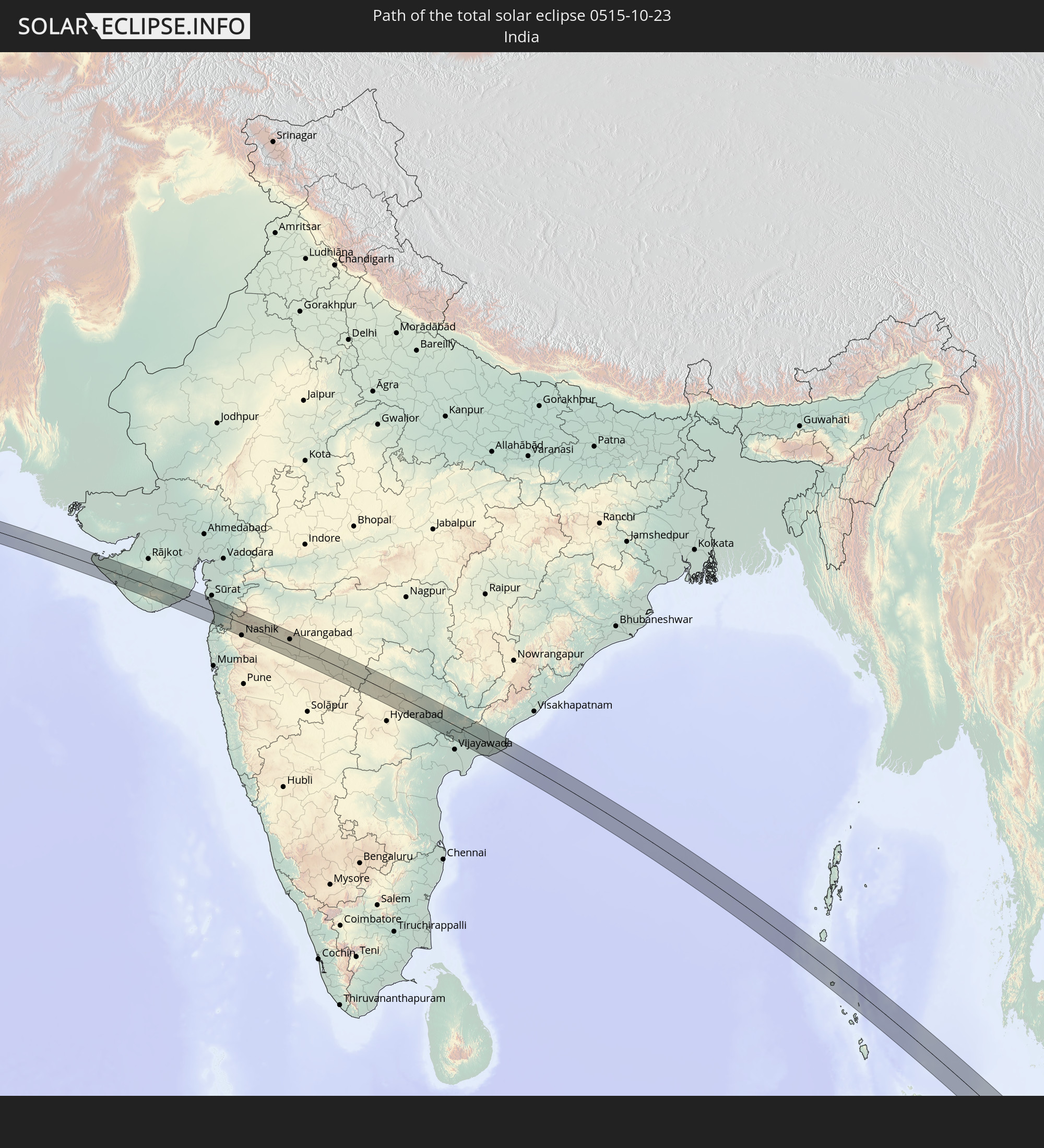 India
India
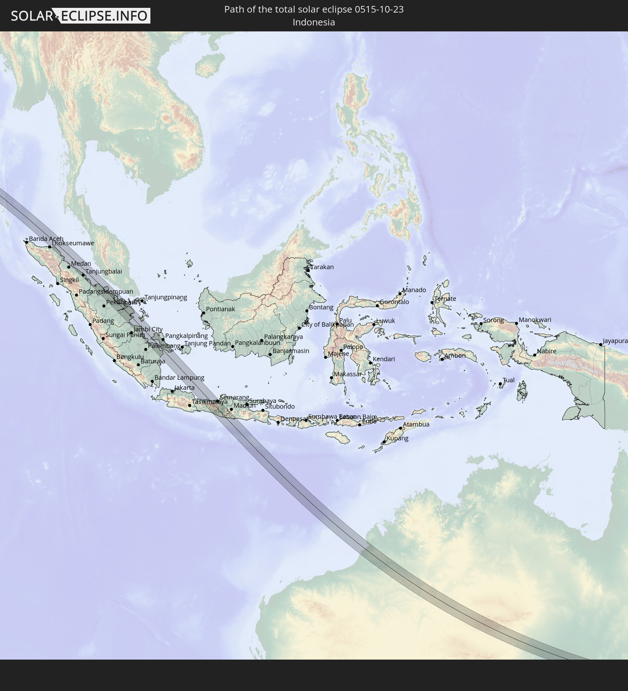 Indonesia
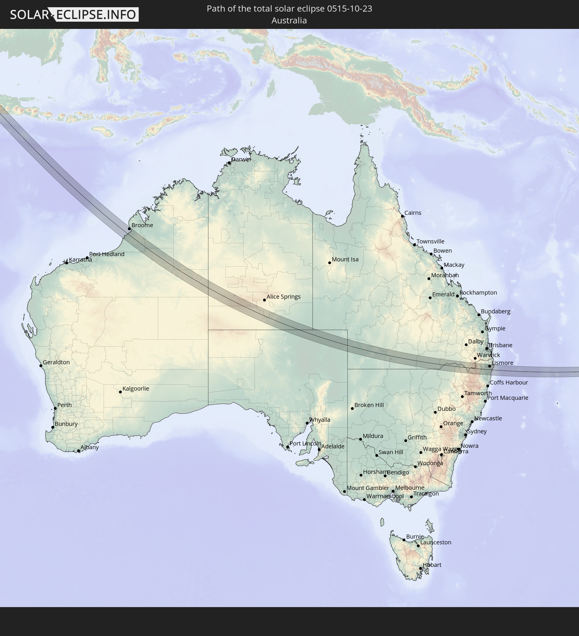 Australia
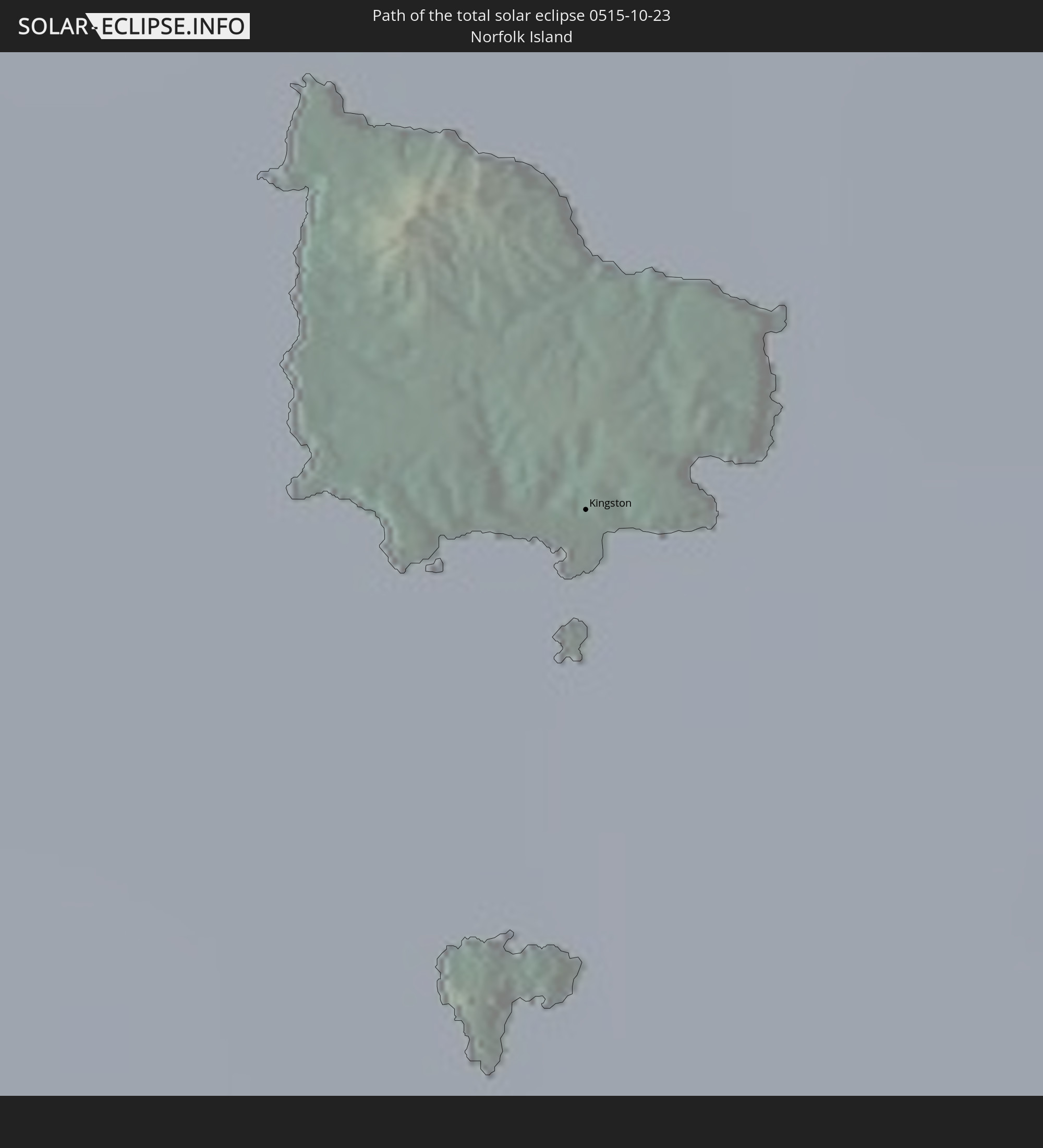 Norfolk Island
In den folgenden Ländern ist die Sonnenfinsternis partiell zu sehen
 Fiji
Fiji
 Russia
 New Zealand
 Wallis and Futuna
 Tonga
Tonga
 Kiribati
 Yemen
Yemen
 Iran
Iran
 Seychelles
 Kazakhstan
 Oman
Oman
 Turkmenistan
 Uzbekistan
 Afghanistan
 Pakistan
 Tajikistan
 India
India
 Kyrgyzstan
 British Indian Ocean Territory
 Maldives
 China
China
 Sri Lanka
 Nepal
Nepal
 Mongolia
 Bangladesh
 Bhutan
 Myanmar
 Indonesia
 Cocos Islands
 Thailand
 Malaysia
 Laos
Laos
 Vietnam
 Cambodia
 Singapore
 Christmas Island
 Australia
 Macau
Macau
 Hong Kong
 Brunei
 Taiwan
 Philippines
 Japan
Japan
 East Timor
 Palau
Palau
 Federated States of Micronesia
 Papua New Guinea
 Solomon Islands
 New Caledonia
 Vanuatu
 Nauru
Nauru
 Norfolk Island
 Tuvalu
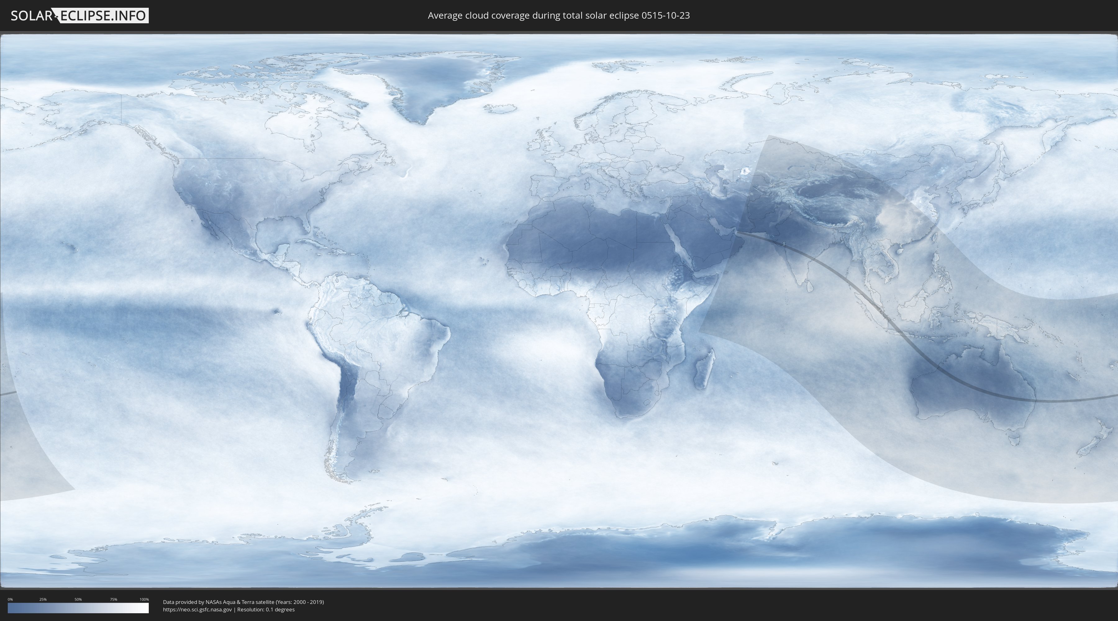
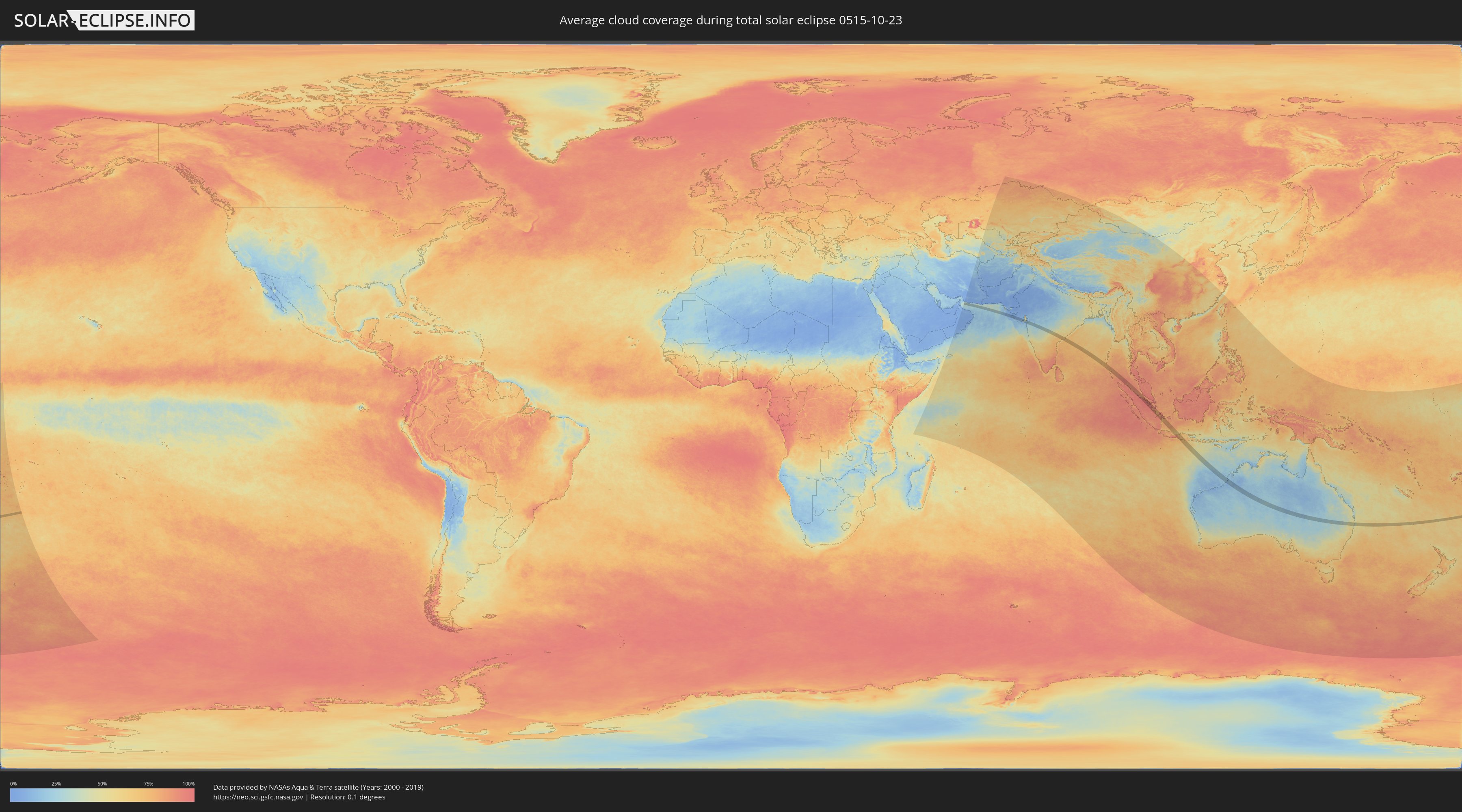
How will be the weather during the total solar eclipse on 10/23/0515?
Where is the best place to see the total solar eclipse of 10/23/0515?
The following maps show the average cloud coverage for the day of the total solar eclipse.
With the help of these maps, it is possible to find the place along the eclipse path, which has the best
chance of a cloudless sky.
Nevertheless, you should consider local circumstances and inform about the weather of your chosen
observation site.
The data is provided by NASAs satellites
AQUA and TERRA.
The cloud maps are averaged over a period of 19 years (2000 - 2019).
Detailed country maps
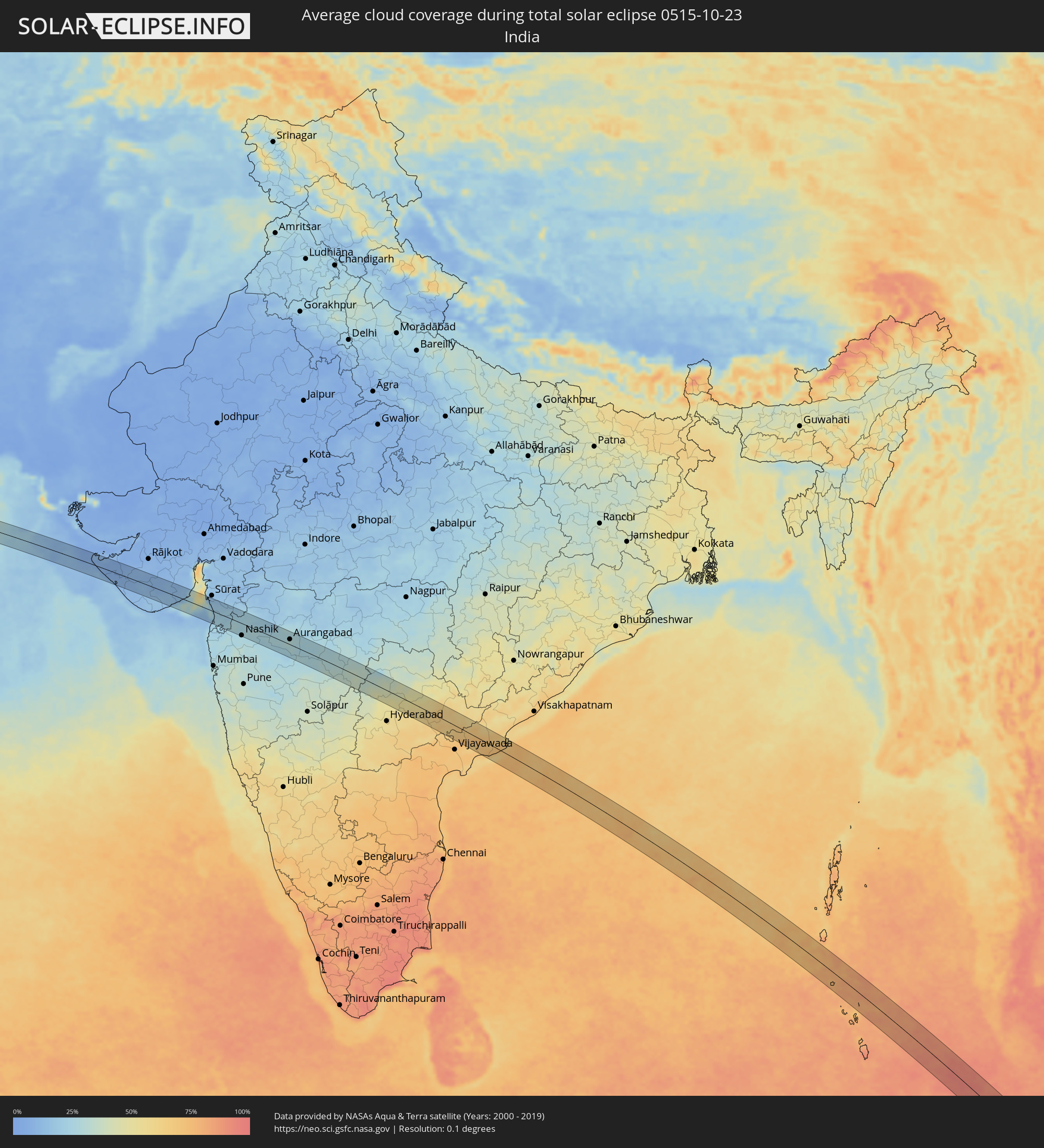 India
India
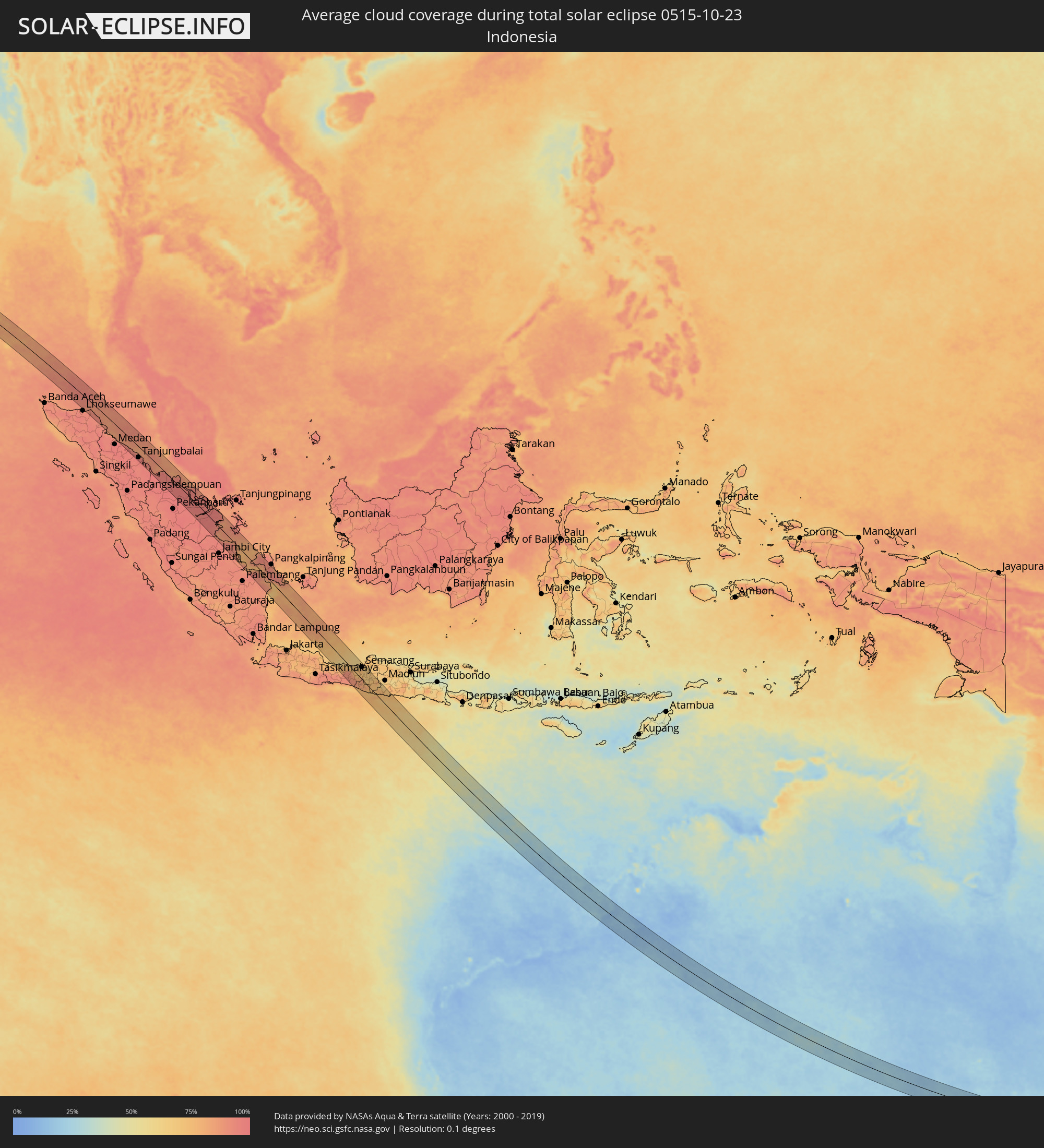 Indonesia
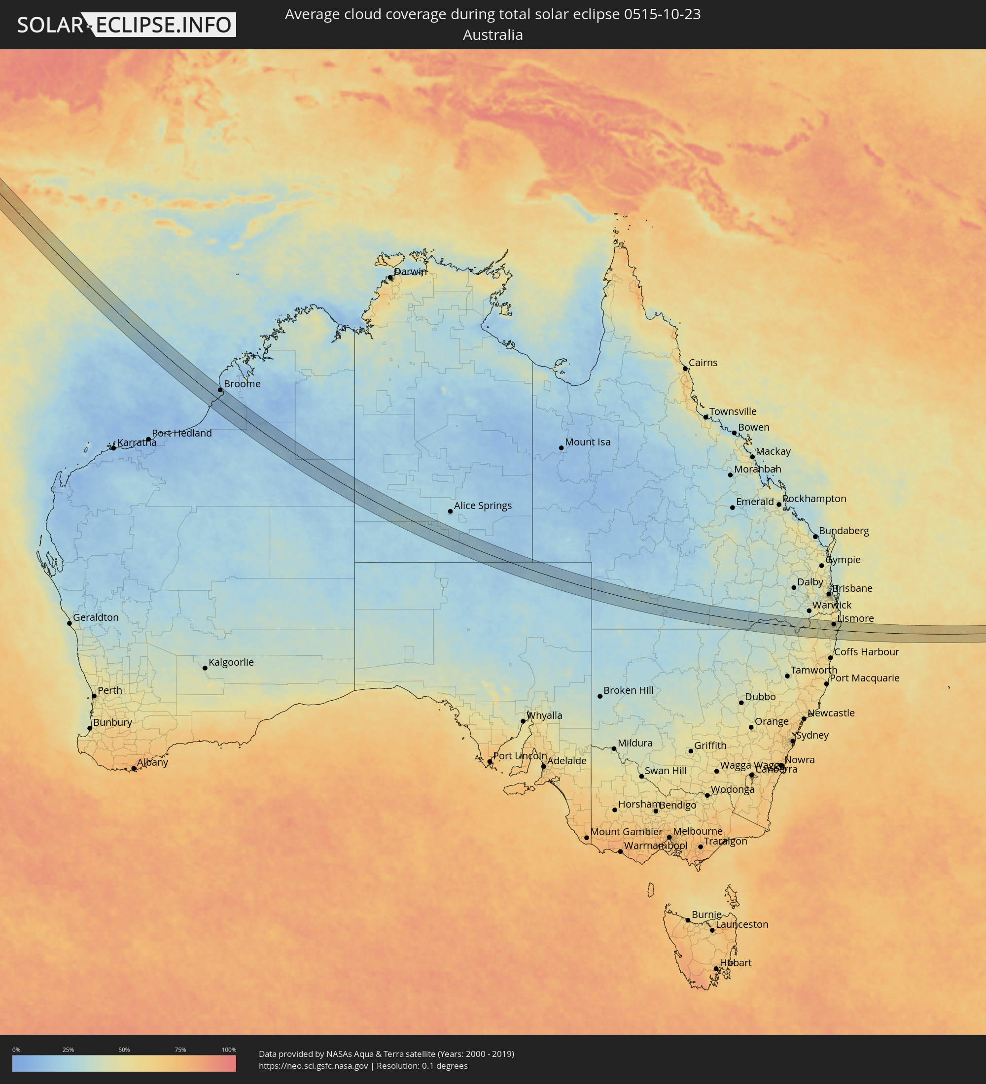 Australia
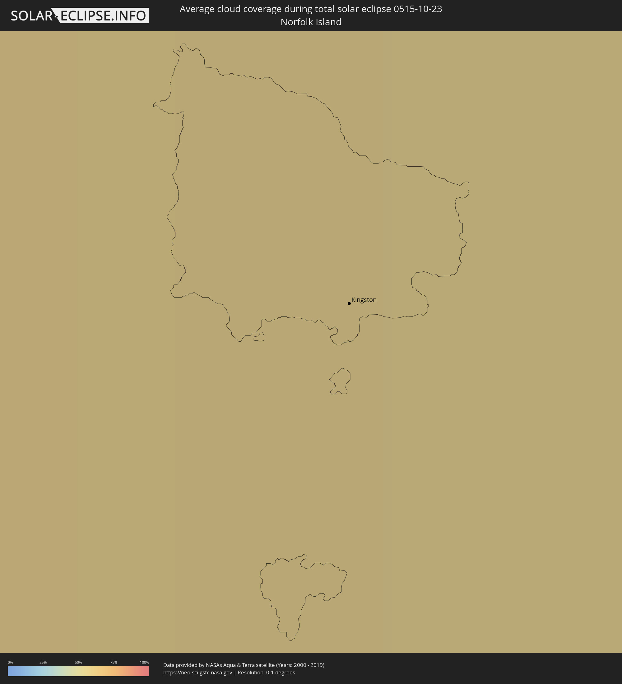 Norfolk Island
Cities inside the path of the eclipse
The following table shows all locations with a population of more than 5,000 inside the eclipse path. Cities which have more than 100,000 inhabitants are marked bold. A click at the locations opens a detailed map.
| City | Type | Eclipse duration | Local time of max. eclipse | Distance to central line | Ø Cloud coverage |
|
Porbandar, Gujarat
|
total | - | 07:43:08 UTC+05:21 | 29 km | 17% |
|
Jodhpur, Gujarat
|
total | - | 07:43:09 UTC+05:21 | 13 km | 7% |
|
Upleta, Gujarat
|
total | - | 07:43:17 UTC+05:21 | 6 km | 8% |
|
Dhorāji, Gujarat
|
total | - | 07:43:20 UTC+05:21 | 11 km | 10% |
|
Jūnāgadh, Gujarat
|
total | - | 07:43:26 UTC+05:21 | 11 km | 11% |
|
Jetpur, Gujarat
|
total | - | 07:43:23 UTC+05:21 | 20 km | 10% |
|
Amreli, Gujarat
|
total | - | 07:43:38 UTC+05:21 | 26 km | 9% |
|
Kundla, Gujarat
|
total | - | 07:43:47 UTC+05:21 | 3 km | 13% |
|
Vapi, Gujarat
|
total | - | 07:44:49 UTC+05:21 | 35 km | 22% |
|
Valsād, Gujarat
|
total | - | 07:44:42 UTC+05:21 | 9 km | 21% |
|
Bilimora, Gujarat
|
total | - | 07:44:38 UTC+05:21 | 8 km | 22% |
|
Nashik, Maharashtra
|
total | - | 07:45:22 UTC+05:21 | 37 km | 27% |
|
Ozar, Maharashtra
|
total | - | 07:45:22 UTC+05:21 | 22 km | 26% |
|
Manmād, Maharashtra
|
total | - | 07:45:30 UTC+05:21 | 16 km | 24% |
|
Kopargaon, Maharashtra
|
total | - | 07:45:43 UTC+05:21 | 21 km | 24% |
|
Yeola, Maharashtra
|
total | - | 07:45:38 UTC+05:21 | 4 km | 25% |
|
Vaijāpur, Maharashtra
|
total | - | 07:45:48 UTC+05:21 | 5 km | 26% |
|
Aurangabad, Maharashtra
|
total | - | 07:46:06 UTC+05:21 | 16 km | 30% |
|
Jālna, Maharashtra
|
total | - | 07:46:22 UTC+05:21 | 36 km | 26% |
|
Mājalgaon, Maharashtra
|
total | - | 07:46:55 UTC+05:21 | 19 km | 26% |
|
Selu, Maharashtra
|
total | - | 07:46:51 UTC+05:21 | 21 km | 27% |
|
Parli Vaijnāth, Maharashtra
|
total | - | 07:47:16 UTC+05:21 | 36 km | 32% |
|
Gangākher, Maharashtra
|
total | - | 07:47:18 UTC+05:21 | 14 km | 32% |
|
Parbhani, Maharashtra
|
total | - | 07:47:08 UTC+05:21 | 17 km | 29% |
|
Ahmadpur, Maharashtra
|
total | - | 07:47:34 UTC+05:21 | 32 km | 35% |
|
Basmat, Maharashtra
|
total | - | 07:47:17 UTC+05:21 | 40 km | 30% |
|
Nanded, Maharashtra
|
total | - | 07:47:28 UTC+05:21 | 31 km | 32% |
|
Dīglūr, Maharashtra
|
total | - | 07:48:00 UTC+05:21 | 19 km | 37% |
|
Bodhan, Telangana
|
total | - | 07:48:05 UTC+05:21 | 7 km | 34% |
|
Nizāmābād, Telangana
|
total | - | 07:48:12 UTC+05:21 | 18 km | 33% |
|
Medak, Telangana
|
total | - | 07:48:42 UTC+05:21 | 37 km | 48% |
|
Kāmāreddi, Telangana
|
total | - | 07:48:34 UTC+05:21 | 6 km | 44% |
|
Sirsilla, Telangana
|
total | - | 07:48:46 UTC+05:21 | 23 km | 43% |
|
Siddipet, Telangana
|
total | - | 07:48:59 UTC+05:21 | 4 km | 46% |
|
Jangaon, Telangana
|
total | - | 07:49:26 UTC+05:21 | 27 km | 57% |
|
Warangal, Telangana
|
total | - | 07:49:29 UTC+05:21 | 21 km | 53% |
|
Khammam, Telangana
|
total | - | 07:50:23 UTC+05:21 | 25 km | 65% |
|
Yellandu, Telangana
|
total | - | 07:50:14 UTC+05:21 | 17 km | 62% |
|
Kottagūdem, Telangana
|
total | - | 07:50:27 UTC+05:21 | 28 km | 63% |
|
Nūzvīd, Andhra Pradesh
|
total | - | 07:51:10 UTC+05:21 | 35 km | 73% |
|
Ellore, Andhra Pradesh
|
total | - | 07:51:24 UTC+05:21 | 30 km | 63% |
|
Akivīdu, Andhra Pradesh
|
total | - | 07:51:41 UTC+05:21 | 28 km | 69% |
|
Bhīmavaram, Andhra Pradesh
|
total | - | 07:51:49 UTC+05:21 | 25 km | 69% |
|
Tādepallegūdem, Andhra Pradesh
|
total | - | 07:51:36 UTC+05:21 | 2 km | 69% |
|
Nidadavole, Andhra Pradesh
|
total | - | 07:51:37 UTC+05:21 | 18 km | 69% |
|
Tanuku, Andhra Pradesh
|
total | - | 07:51:45 UTC+05:21 | 4 km | 68% |
|
Narasapur, Andhra Pradesh
|
total | - | 07:52:01 UTC+05:21 | 26 km | 68% |
|
Rājahmundry, Andhra Pradesh
|
total | - | 07:51:37 UTC+05:21 | 33 km | 69% |
|
Mandapeta, Andhra Pradesh
|
total | - | 07:51:49 UTC+05:21 | 27 km | 67% |
|
Amalāpuram, Andhra Pradesh
|
total | - | 07:52:06 UTC+05:21 | 4 km | 72% |
|
Kisaran, North Sumatra
|
total | - | 10:13:46 UTC+07:07 | 54 km | 97% |
|
Tanjungbalai, North Sumatra
|
total | - | 10:14:04 UTC+07:07 | 41 km | 95% |
|
Dumai, Riau
|
total | - | 10:18:44 UTC+07:07 | 17 km | 96% |
|
Kuala Tungkal, Jambi
|
total | - | 10:26:24 UTC+07:07 | 50 km | 93% |
|
Mendaha, Jambi
|
total | - | 10:26:59 UTC+07:07 | 55 km | 95% |
|
Simpang, Jambi
|
total | - | 10:28:16 UTC+07:07 | 34 km | 93% |
|
Tegal, Central Java
|
total | - | 10:48:06 UTC+07:07 | 50 km | 75% |
|
Slawi, Central Java
|
total | - | 10:48:19 UTC+07:07 | 59 km | 80% |
|
Tarub, Central Java
|
total | - | 10:48:16 UTC+07:07 | 53 km | 75% |
|
Pemalang, Central Java
|
total | - | 10:48:34 UTC+07:07 | 34 km | 74% |
|
Petarukan, Central Java
|
total | - | 10:48:40 UTC+07:07 | 28 km | 74% |
|
Comal, Central Java
|
total | - | 10:48:54 UTC+07:07 | 21 km | 75% |
|
Buaran, Central Java
|
total | - | 10:49:13 UTC+07:07 | 31 km | 88% |
|
Wonopringgo, Central Java
|
total | - | 10:49:12 UTC+07:07 | 20 km | 79% |
|
Wiradesa, Central Java
|
total | - | 10:49:01 UTC+07:07 | 13 km | 75% |
|
Pekalongan, Central Java
|
total | - | 10:49:07 UTC+07:07 | 9 km | 74% |
|
Wonosobo, Central Java
|
total | - | 10:50:30 UTC+07:07 | 26 km | 85% |
|
Kutoarjo, Central Java
|
total | - | 10:51:15 UTC+07:07 | 52 km | 84% |
|
Weleri, Central Java
|
total | - | 10:50:01 UTC+07:07 | 17 km | 71% |
|
Magelang, Central Java
|
total | - | 10:51:19 UTC+07:07 | 9 km | 82% |
|
Mertoyudan, Central Java
|
total | - | 10:51:26 UTC+07:07 | 12 km | 82% |
|
Srandakan, Yogyakarta
|
total | - | 10:52:20 UTC+07:07 | 42 km | 76% |
|
Bambanglipuro, Yogyakarta
|
total | - | 10:52:25 UTC+07:07 | 40 km | 75% |
|
Muntilan, Central Java
|
total | - | 10:51:41 UTC+07:07 | 11 km | 84% |
|
Pandak, Yogyakarta
|
total | - | 10:52:22 UTC+07:07 | 36 km | 76% |
|
Godean, Yogyakarta
|
total | - | 10:52:05 UTC+07:07 | 25 km | 83% |
|
Gamping Lor, Yogyakarta
|
total | - | 10:52:11 UTC+07:07 | 25 km | 83% |
|
Bantul, Yogyakarta
|
total | - | 10:52:23 UTC+07:07 | 32 km | 76% |
|
Kasihan, Yogyakarta
|
total | - | 10:52:16 UTC+07:07 | 27 km | 83% |
|
Sleman, Yogyakarta
|
total | - | 10:52:05 UTC+07:07 | 16 km | 80% |
|
Sewon, Yogyakarta
|
total | - | 10:52:25 UTC+07:07 | 28 km | 80% |
|
Yogyakarta, Yogyakarta
|
total | - | 10:52:16 UTC+07:07 | 22 km | 83% |
|
Melati, Yogyakarta
|
total | - | 10:52:08 UTC+07:07 | 17 km | 80% |
|
Ambarawa, Central Java
|
total | - | 10:51:14 UTC+07:07 | 21 km | 73% |
|
Ungaran, Central Java
|
total | - | 10:51:00 UTC+07:07 | 31 km | 74% |
|
Semarang, Central Java
|
total | - | 10:50:43 UTC+07:07 | 44 km | 73% |
|
Salatiga, Central Java
|
total | - | 10:51:33 UTC+07:07 | 24 km | 67% |
|
Candi Prambanan, Central Java
|
total | - | 10:52:25 UTC+07:07 | 8 km | 83% |
|
Wedi, Central Java
|
total | - | 10:52:33 UTC+07:07 | 0 km | 75% |
|
Boyolali, Central Java
|
total | - | 10:52:09 UTC+07:07 | 17 km | 66% |
|
Klaten, Central Java
|
total | - | 10:52:32 UTC+07:07 | 5 km | 75% |
|
Karanganom, Central Java
|
total | - | 10:52:27 UTC+07:07 | 11 km | 69% |
|
Ceper, Central Java
|
total | - | 10:52:36 UTC+07:07 | 13 km | 74% |
|
Gatak, Central Java
|
total | - | 10:52:29 UTC+07:07 | 21 km | 70% |
|
Kartasura, Central Java
|
total | - | 10:52:28 UTC+07:07 | 27 km | 70% |
|
Baki, Central Java
|
total | - | 10:52:40 UTC+07:07 | 26 km | 71% |
|
Surakarta, Central Java
|
total | - | 10:52:39 UTC+07:07 | 34 km | 71% |
|
Selogiri, Central Java
|
total | - | 10:53:11 UTC+07:07 | 20 km | 71% |
|
Jaten, Central Java
|
total | - | 10:52:49 UTC+07:07 | 38 km | 73% |
|
Jatiroto, Central Java
|
total | - | 10:53:52 UTC+07:07 | 32 km | 73% |
|
Broome, Western Australia
|
total | - | 12:29:02 UTC+08:00 | 44 km | 20% |
|
Goondiwindi, Queensland
|
total | - | 15:29:31 UTC+10:00 | 28 km | 34% |
|
Gordon, New South Wales
|
total | - | 15:32:23 UTC+10:00 | 32 km | 46% |
|
Casino, New South Wales
|
total | - | 15:32:41 UTC+10:00 | 20 km | 46% |
|
Lismore, New South Wales
|
total | - | 15:32:55 UTC+10:00 | 26 km | 51% |
|
East Lismore, New South Wales
|
total | - | 15:32:56 UTC+10:00 | 25 km | 51% |
|
Goonellabah, New South Wales
|
total | - | 15:32:58 UTC+10:00 | 26 km | 51% |
|
Ballina, New South Wales
|
total | - | 15:33:14 UTC+10:00 | 23 km | 44% |
|
East Ballina, New South Wales
|
total | - | 15:33:15 UTC+10:00 | 22 km | 44% |
|
Kingston
|
total | - | 16:56:23 UTC+11:12 | 26 km | 58% |