Total solar eclipse of 04/21/0627
| Day of week: | Saturday |
| Maximum duration of eclipse: | 06m19s |
| Maximum width of eclipse path: | 248 km |
| Saros cycle: | 87 |
| Coverage: | 100% |
| Magnitude: | 1.0758 |
| Gamma: | -0.1462 |
Wo kann man die Sonnenfinsternis vom 04/21/0627 sehen?
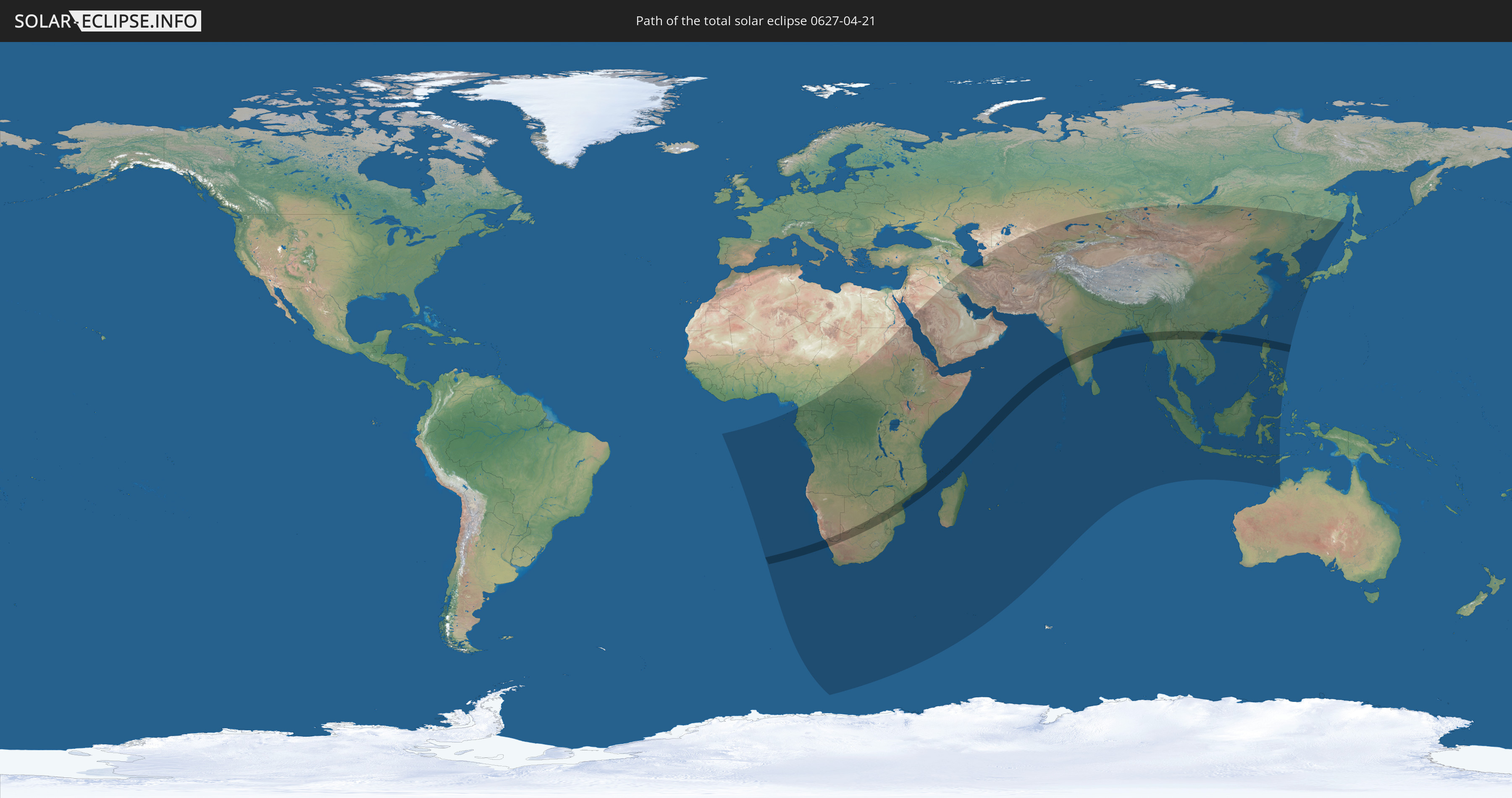
Die Sonnenfinsternis am 04/21/0627 kann man in 82 Ländern als partielle Sonnenfinsternis beobachten.
Der Finsternispfad verläuft durch 16 Länder. Nur in diesen Ländern ist sie als total Sonnenfinsternis zu sehen.
In den folgenden Ländern ist die Sonnenfinsternis total zu sehen
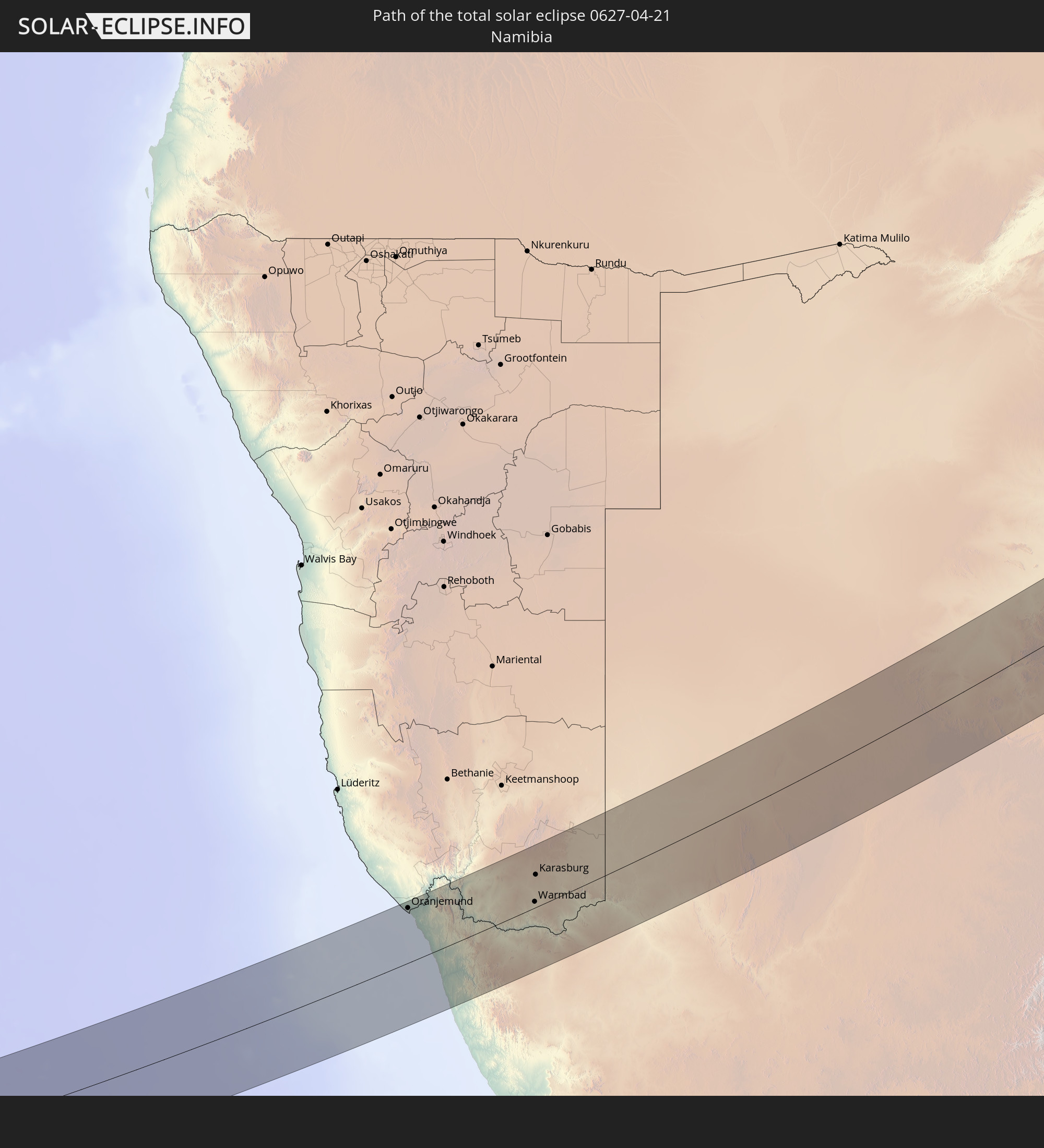 Namibia
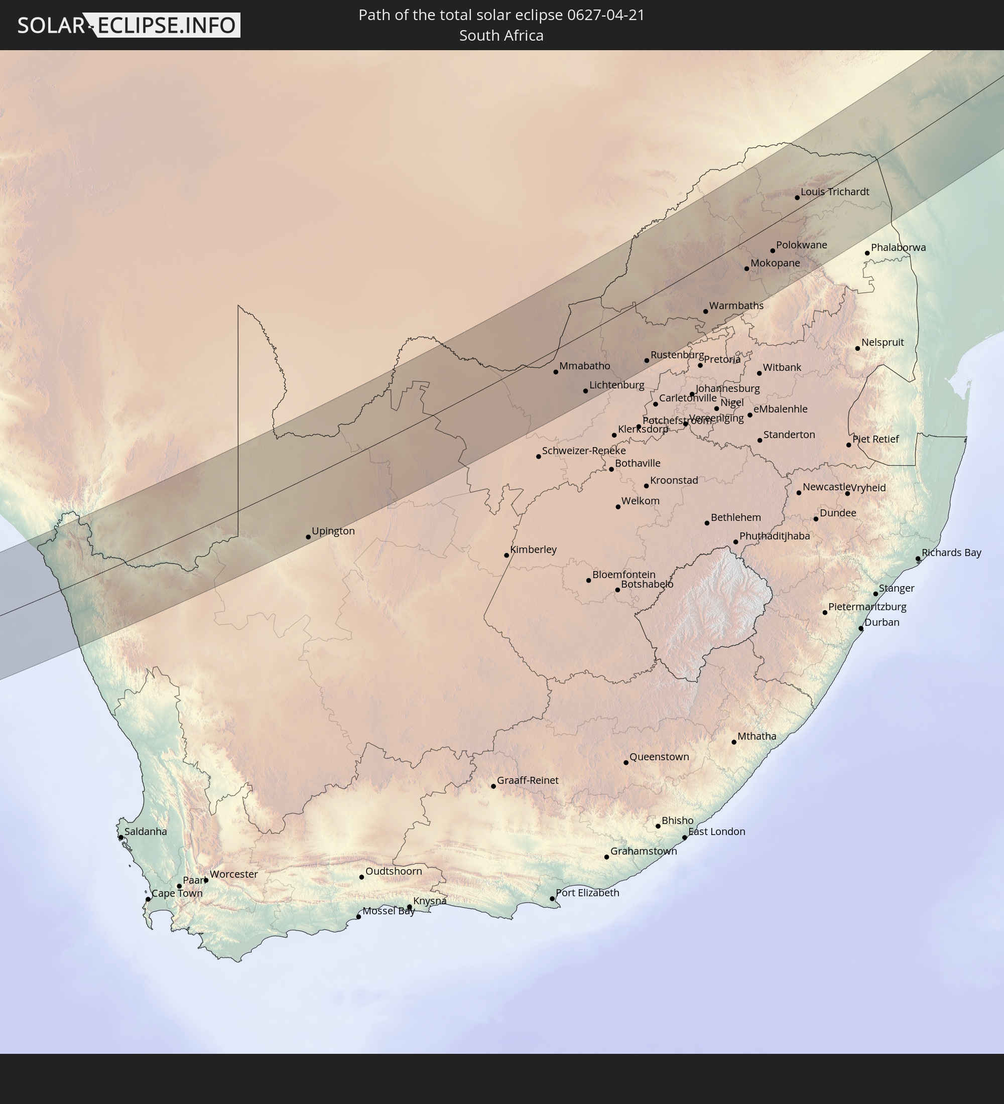 South Africa
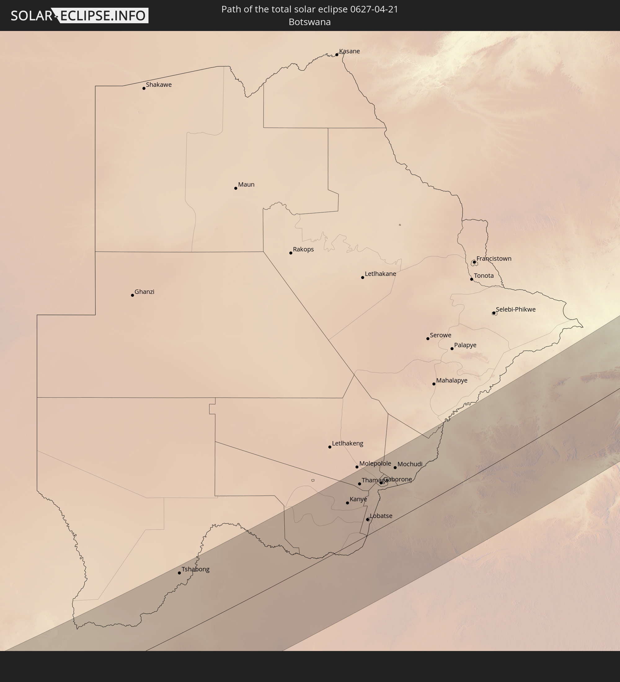 Botswana
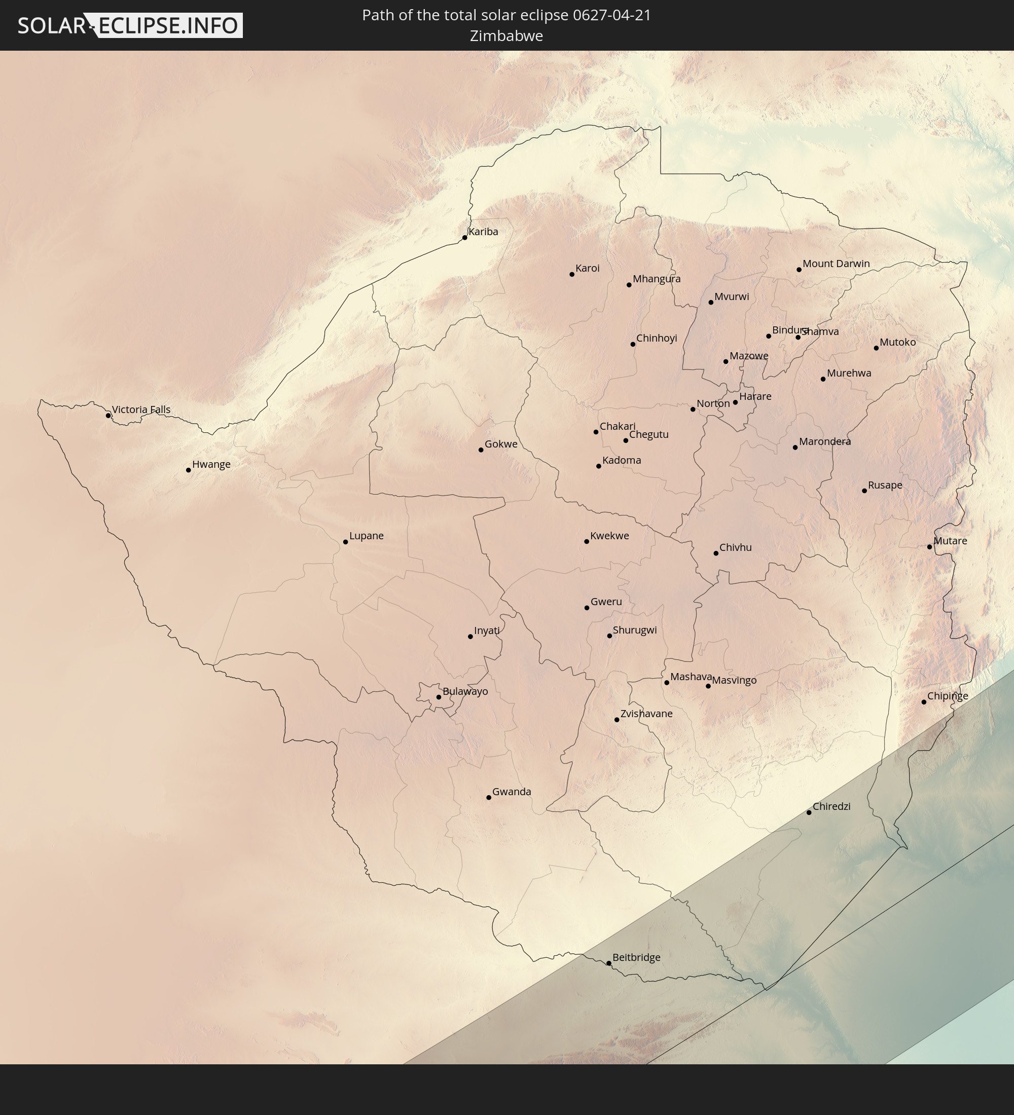 Zimbabwe
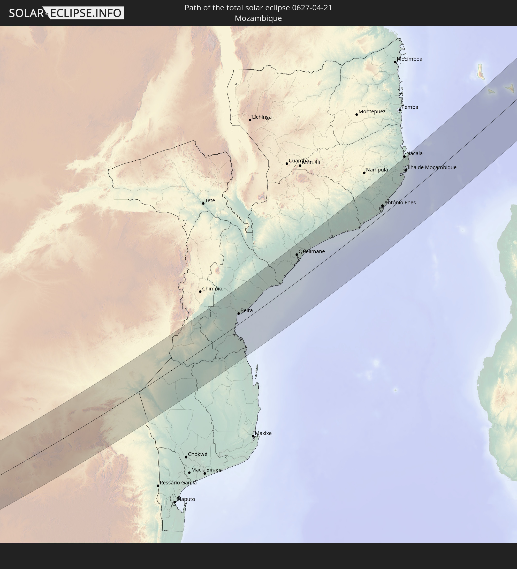 Mozambique
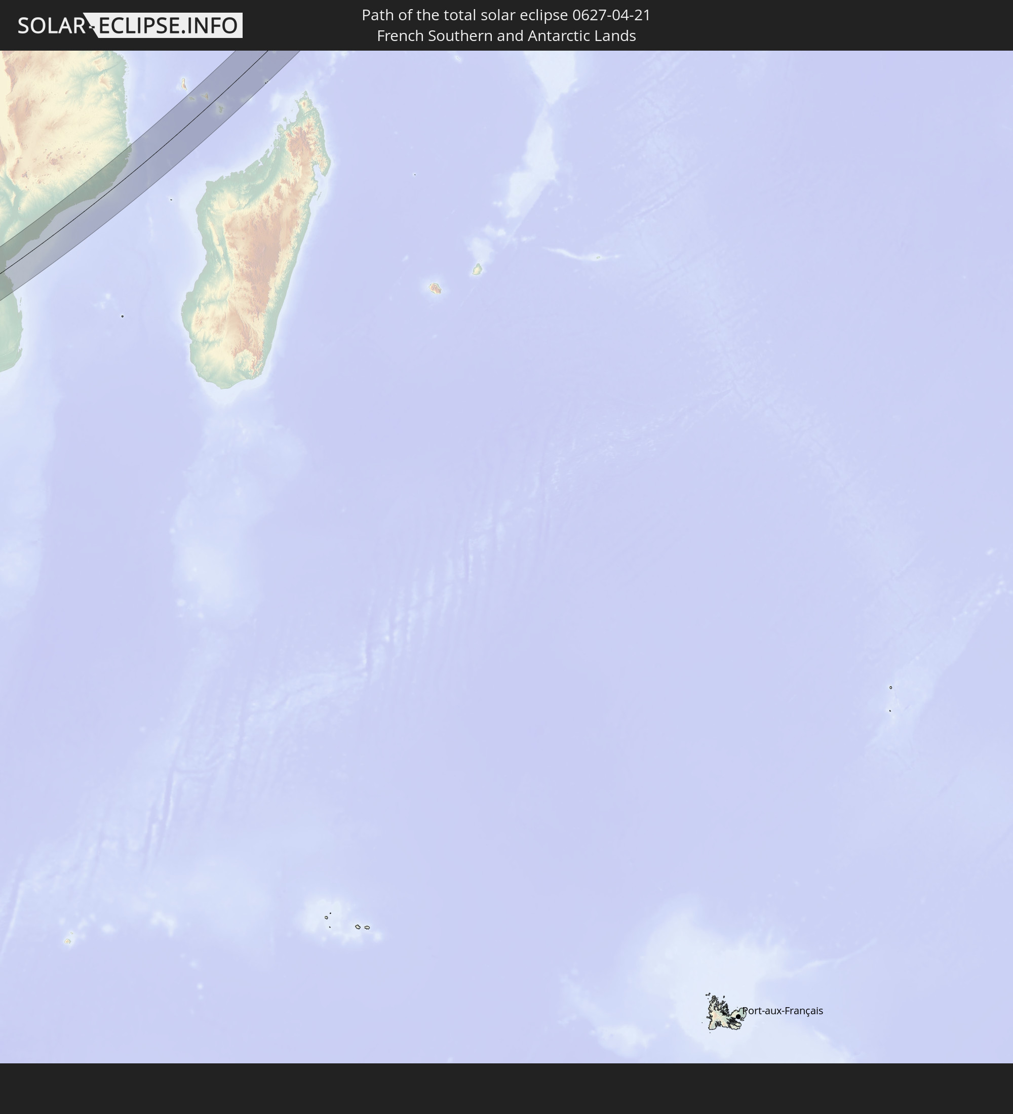 French Southern and Antarctic Lands
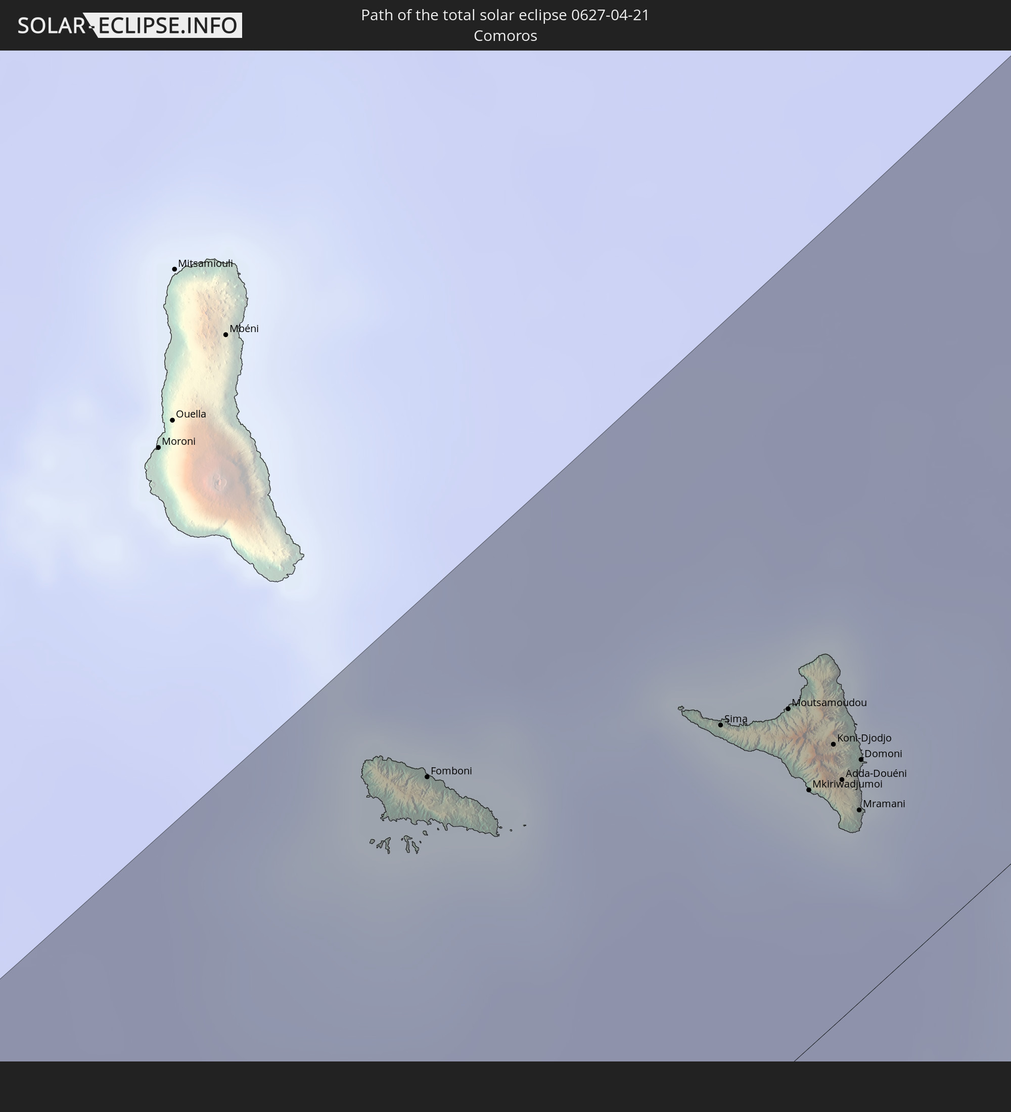 Comoros
 Mayotte
 Seychelles
 India
India
 China
China
 Myanmar
 Thailand
 Laos
Laos
 Vietnam
 Philippines
In den folgenden Ländern ist die Sonnenfinsternis partiell zu sehen
 Russia
 Equatorial Guinea
 São Tomé and Príncipe
 Cameroon
 Gabon
Gabon
 Republic of the Congo
 Angola
 Namibia
 Democratic Republic of the Congo
 Chad
Chad
 Central African Republic
 South Africa
 Botswana
 Sudan
Sudan
 Zambia
 Egypt
Egypt
 Zimbabwe
 Lesotho
 Rwanda
 Burundi
 Tanzania
 Uganda
 Mozambique
 Swaziland
 Malawi
 Ethiopia
 Kenya
Kenya
 Saudi Arabia
 Eritrea
 Iraq
Iraq
 French Southern and Antarctic Lands
 Somalia
 Djibouti
 Yemen
Yemen
 Madagascar
 Comoros
 Iran
Iran
 Mayotte
 Seychelles
 Kazakhstan
 Kuwait
 Bahrain
 Qatar
Qatar
 United Arab Emirates
 Oman
Oman
 Turkmenistan
 Réunion
 Uzbekistan
 Mauritius
 Afghanistan
 Pakistan
 Tajikistan
 India
India
 Kyrgyzstan
 British Indian Ocean Territory
 Maldives
 China
China
 Sri Lanka
 Nepal
Nepal
 Mongolia
 Bangladesh
 Bhutan
 Myanmar
 Indonesia
 Cocos Islands
 Thailand
 Malaysia
 Laos
Laos
 Vietnam
 Cambodia
 Singapore
 Christmas Island
 Australia
 Macau
Macau
 Hong Kong
 Brunei
 Taiwan
 Philippines
 Japan
Japan
 East Timor
 North Korea
 South Korea
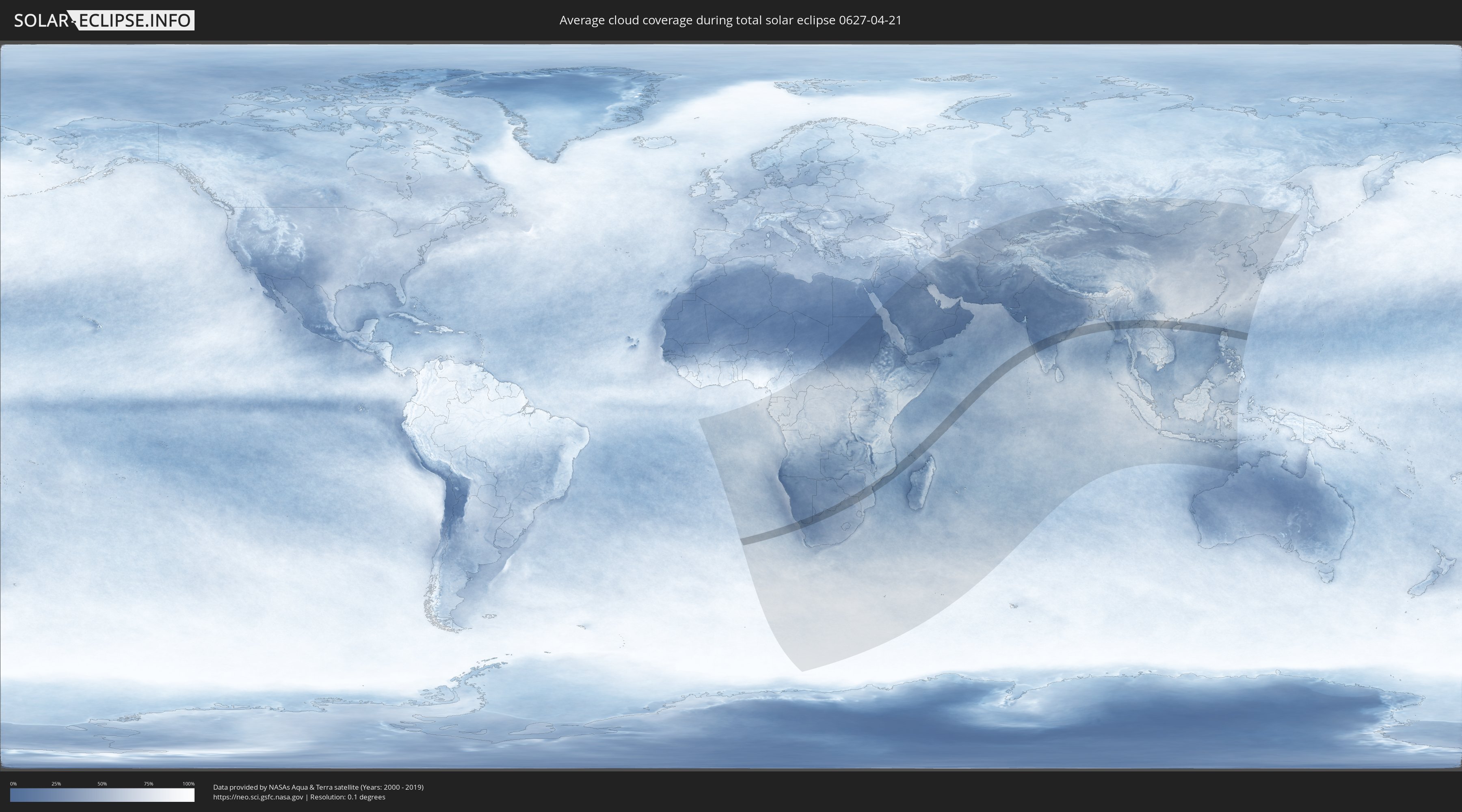
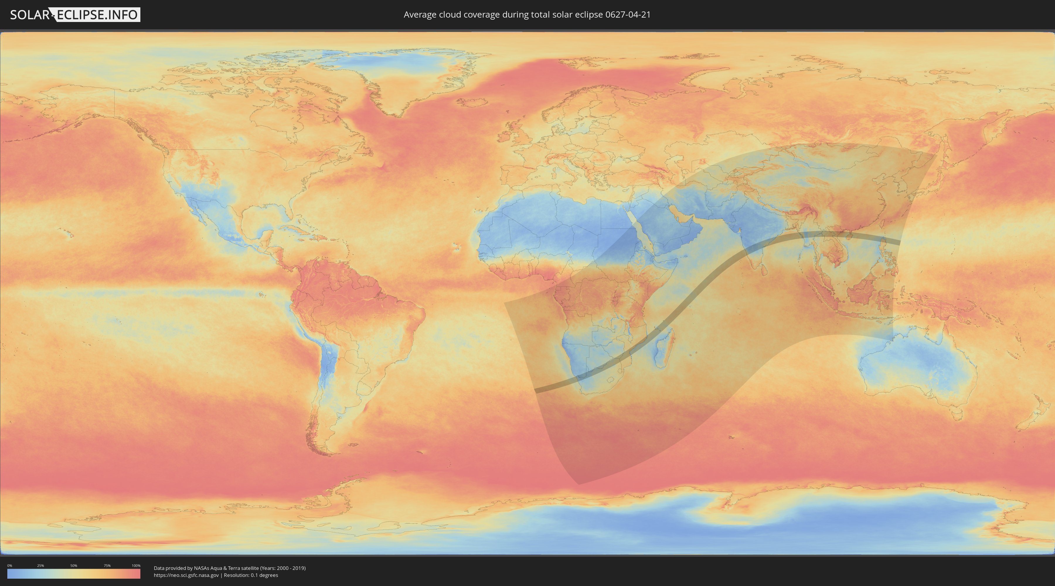
How will be the weather during the total solar eclipse on 04/21/0627?
Where is the best place to see the total solar eclipse of 04/21/0627?
The following maps show the average cloud coverage for the day of the total solar eclipse.
With the help of these maps, it is possible to find the place along the eclipse path, which has the best
chance of a cloudless sky.
Nevertheless, you should consider local circumstances and inform about the weather of your chosen
observation site.
The data is provided by NASAs satellites
AQUA and TERRA.
The cloud maps are averaged over a period of 19 years (2000 - 2019).
Detailed country maps
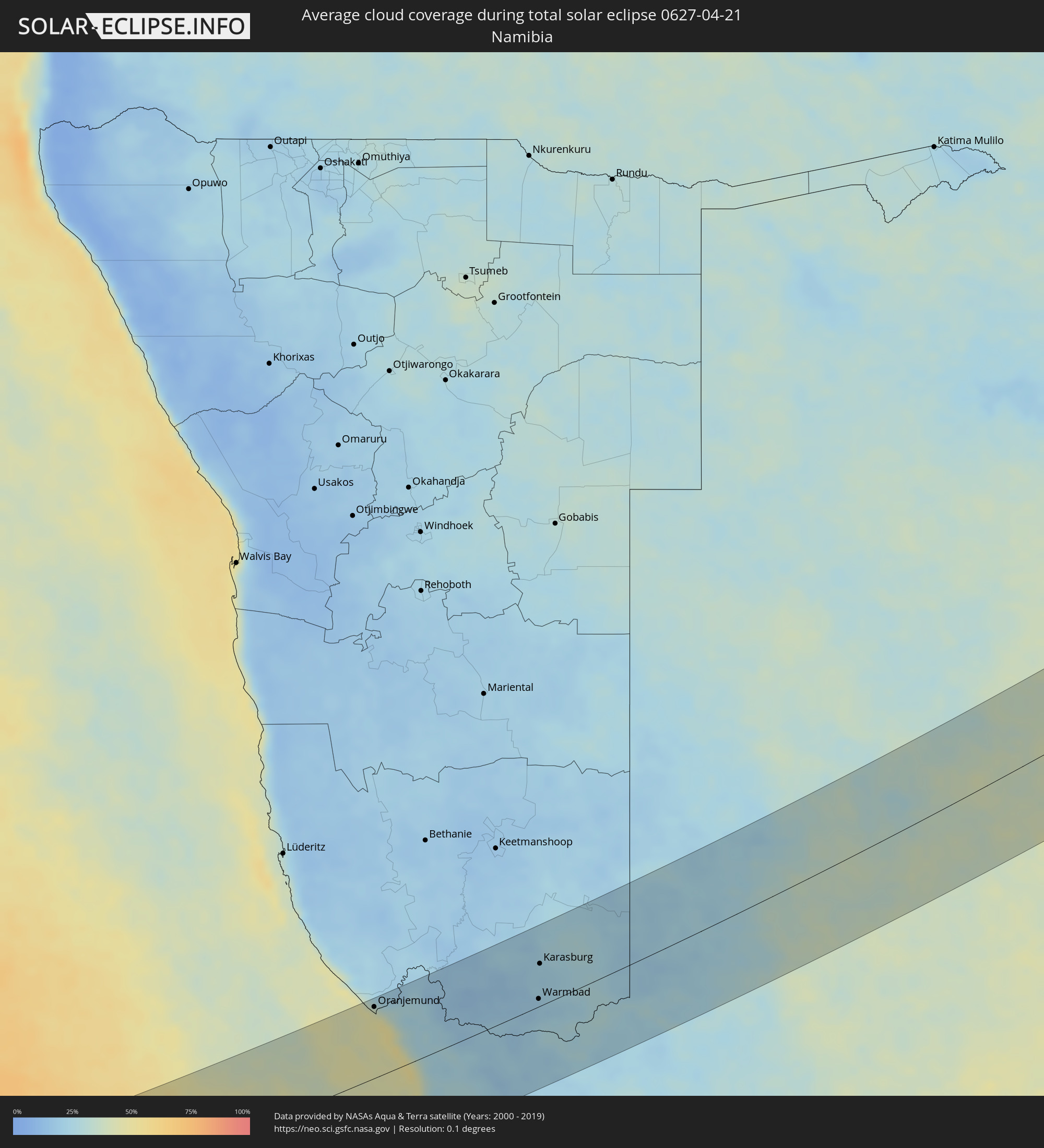 Namibia
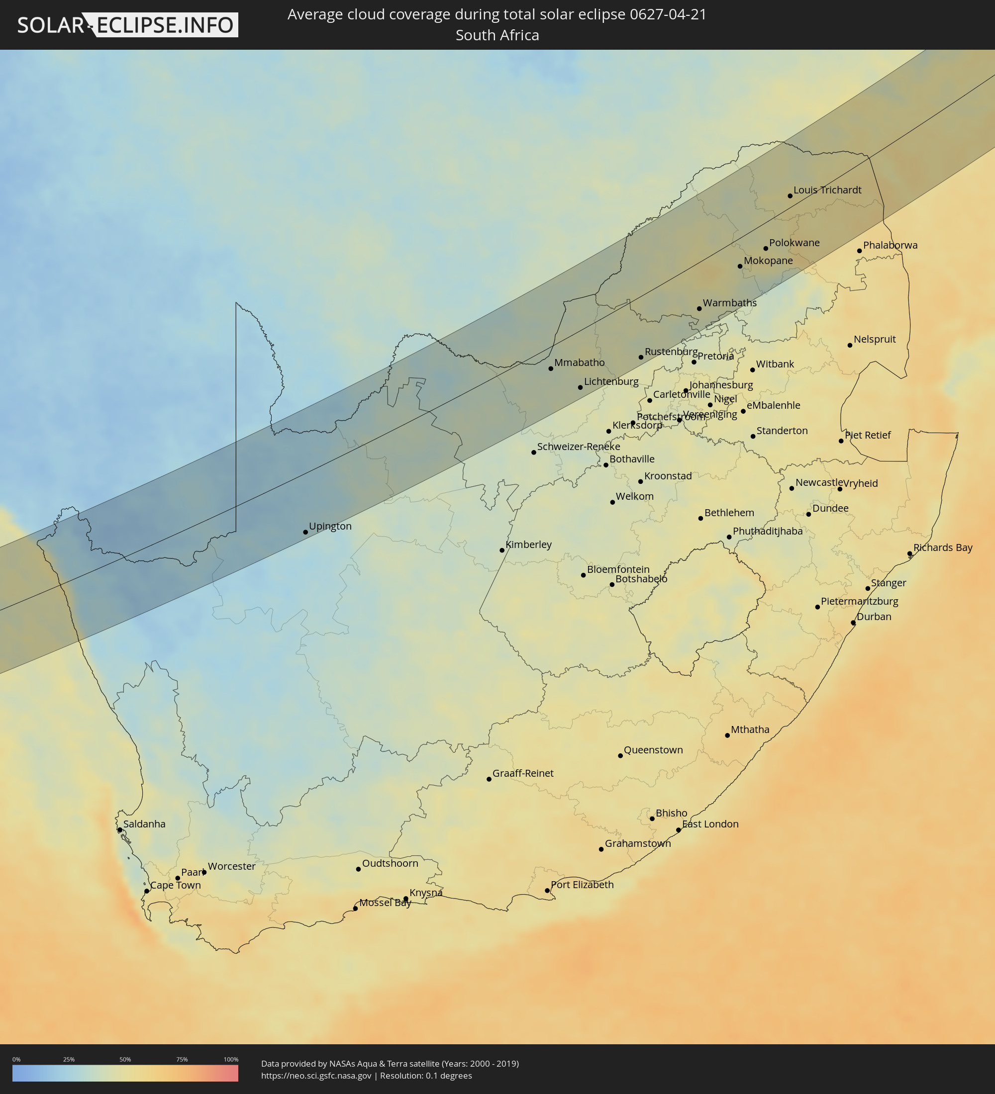 South Africa
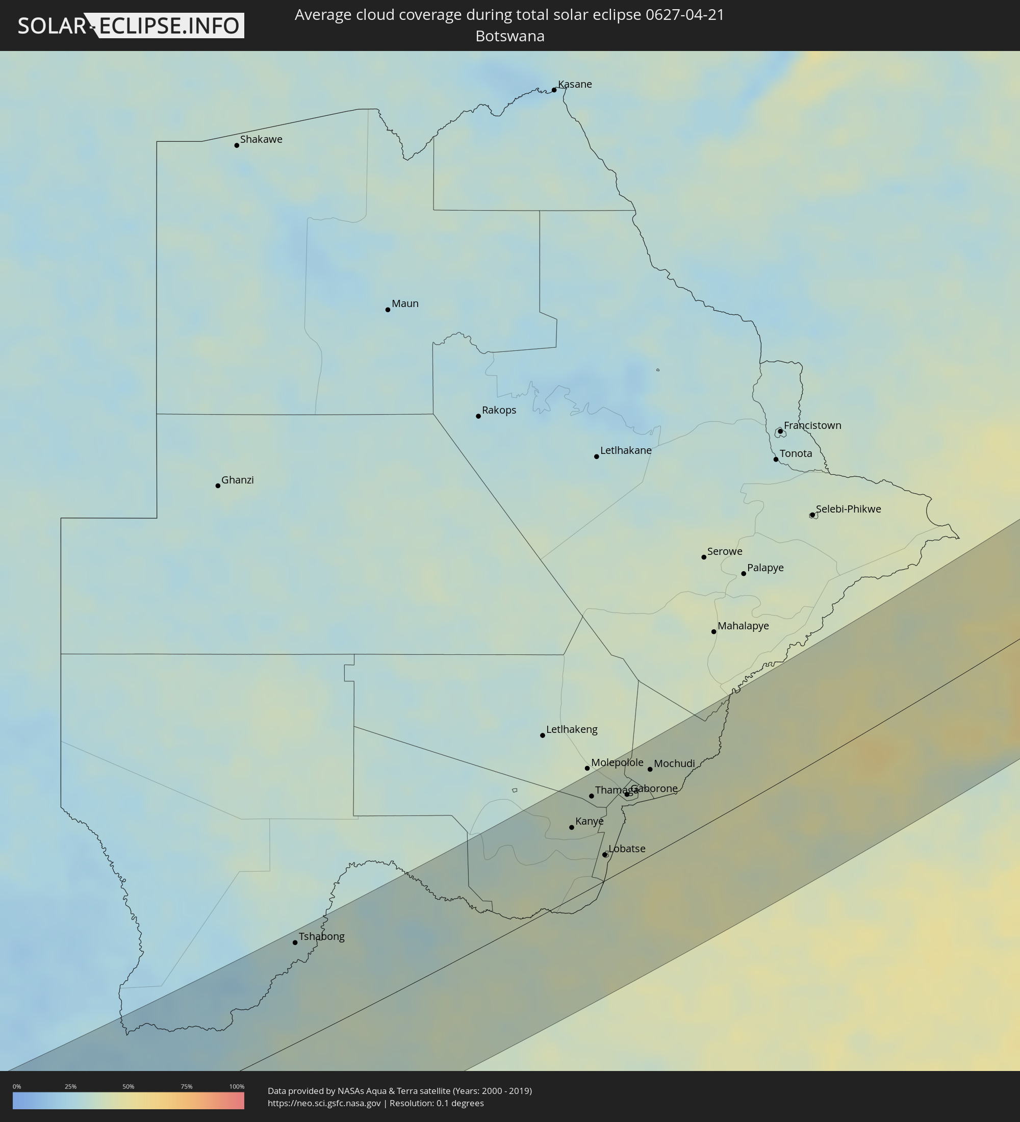 Botswana
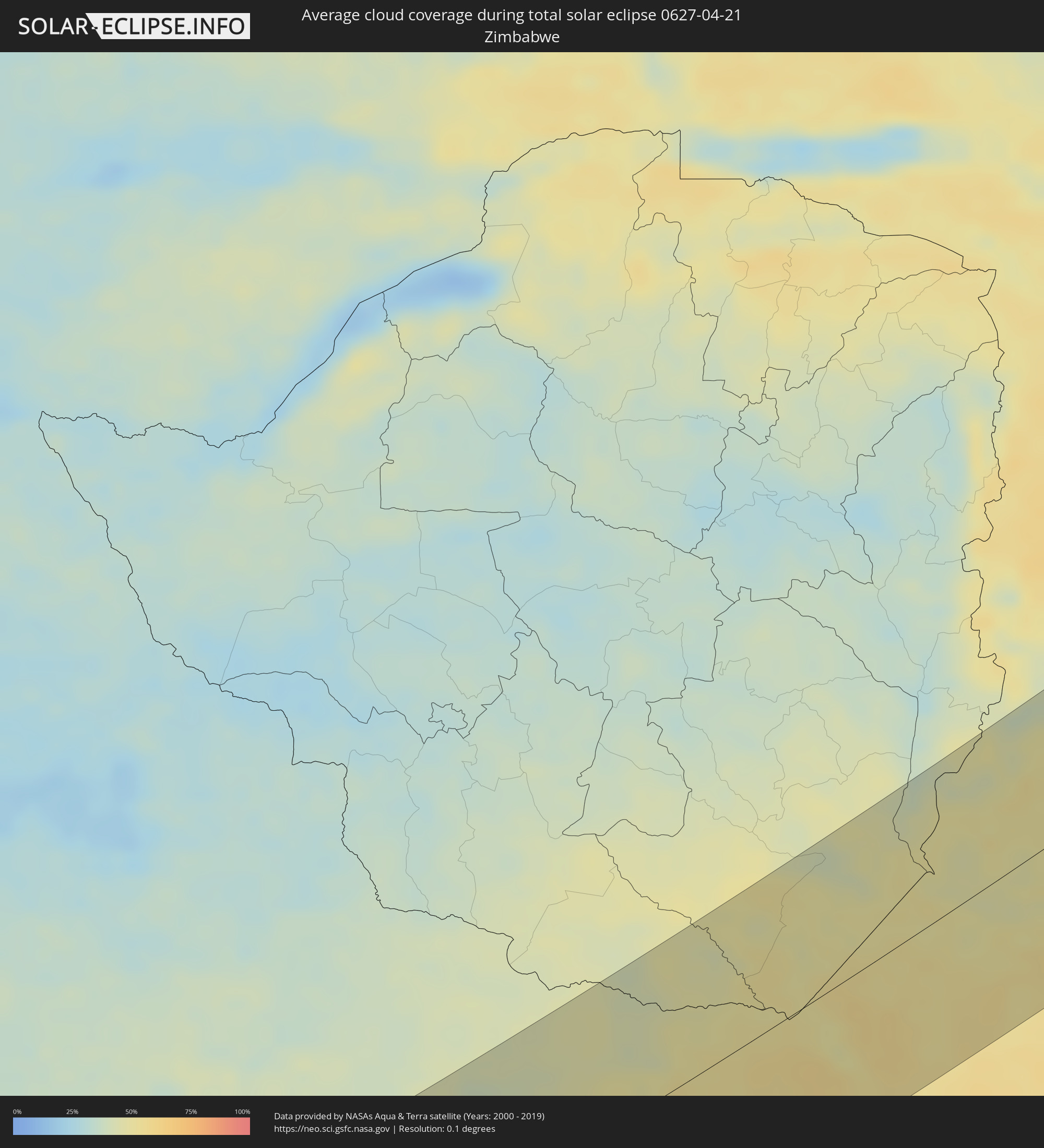 Zimbabwe
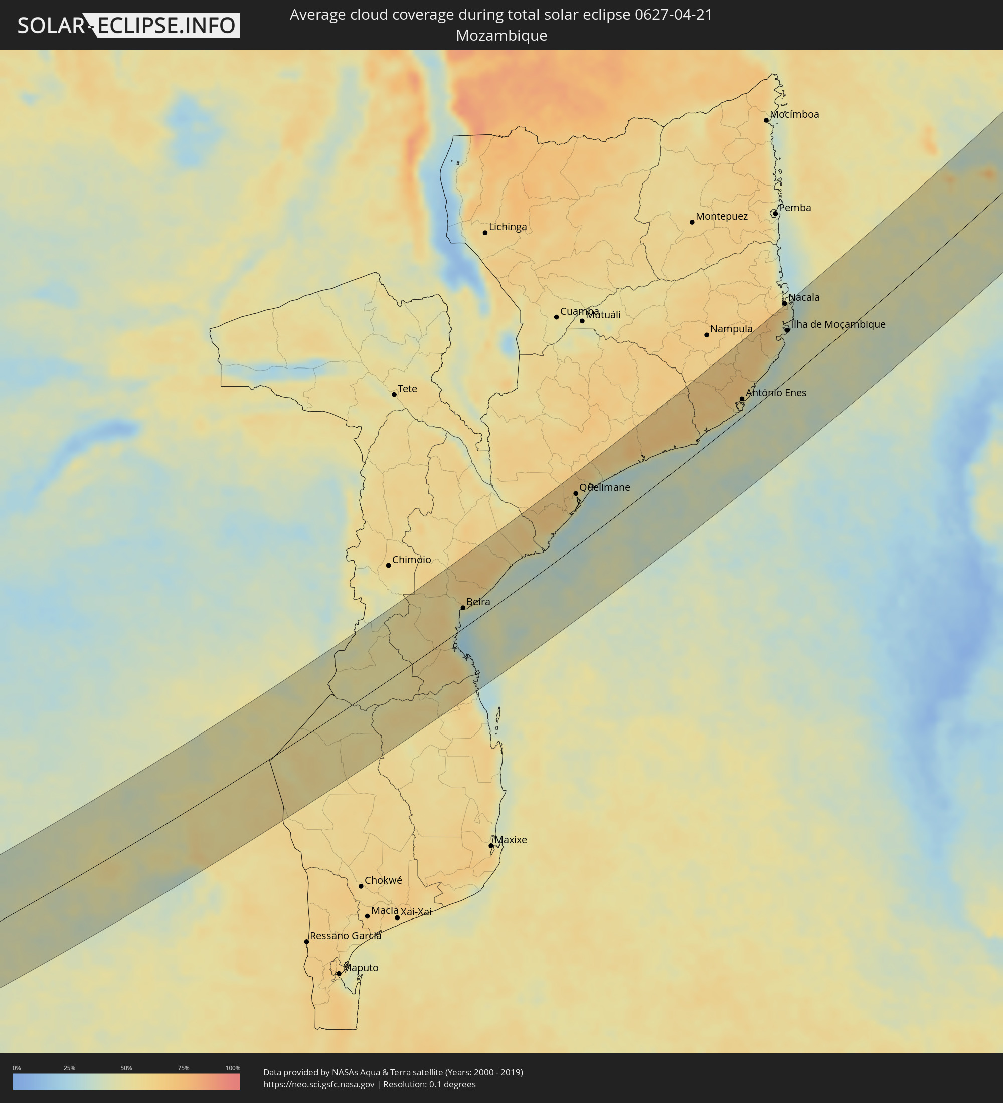 Mozambique
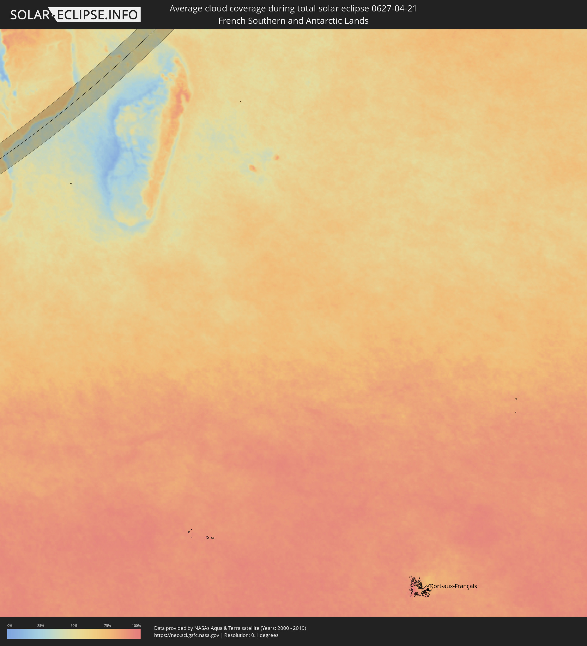 French Southern and Antarctic Lands
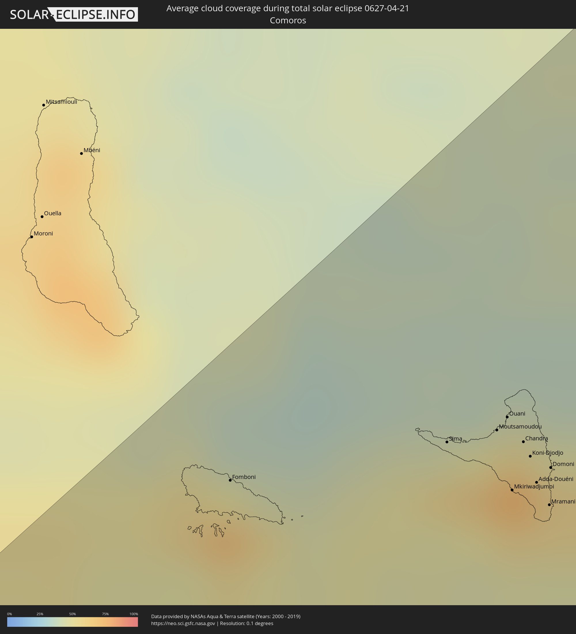 Comoros
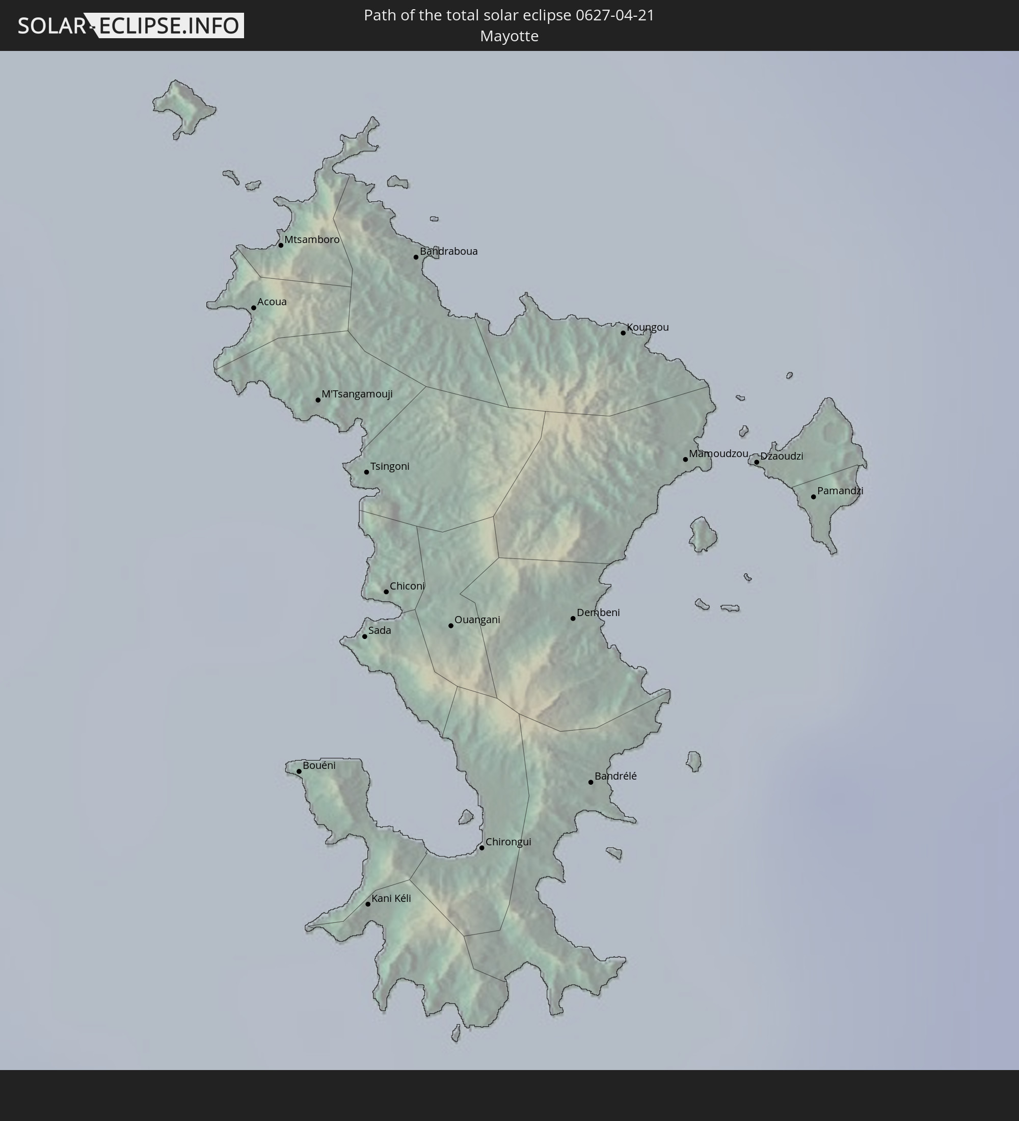
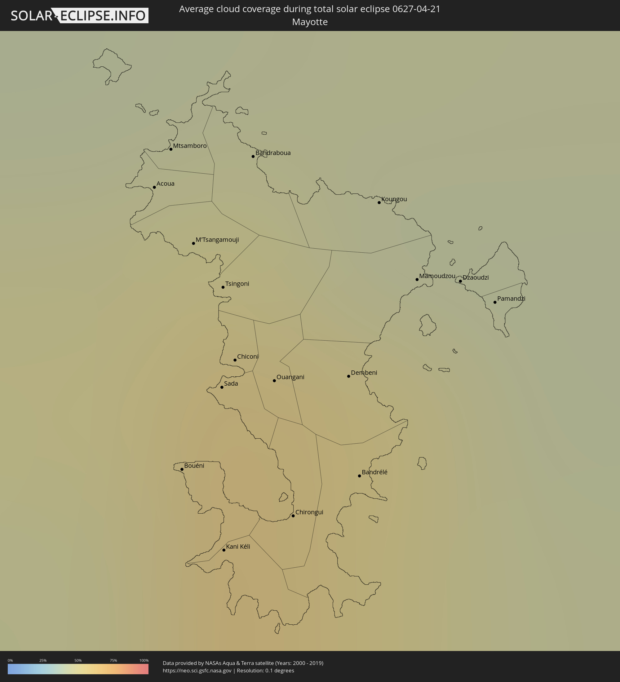 Mayotte
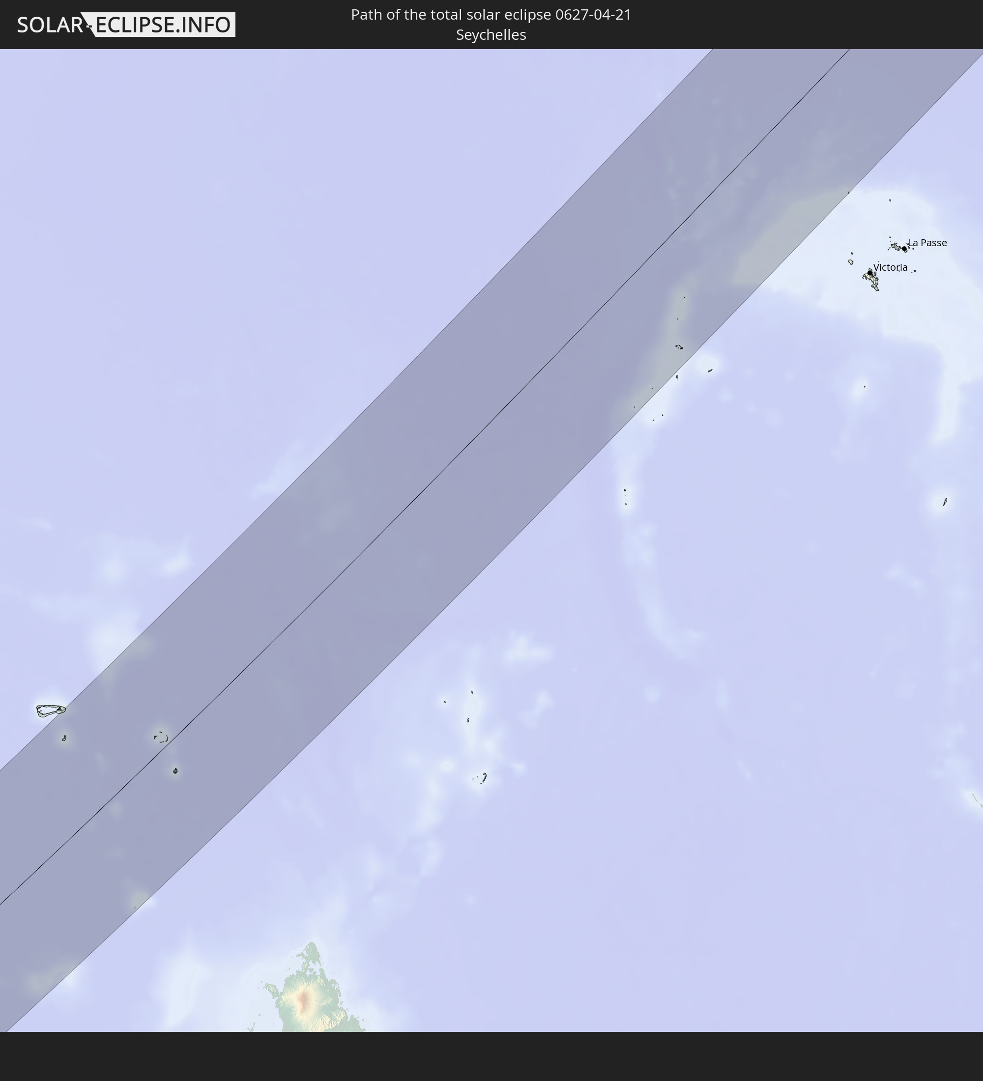
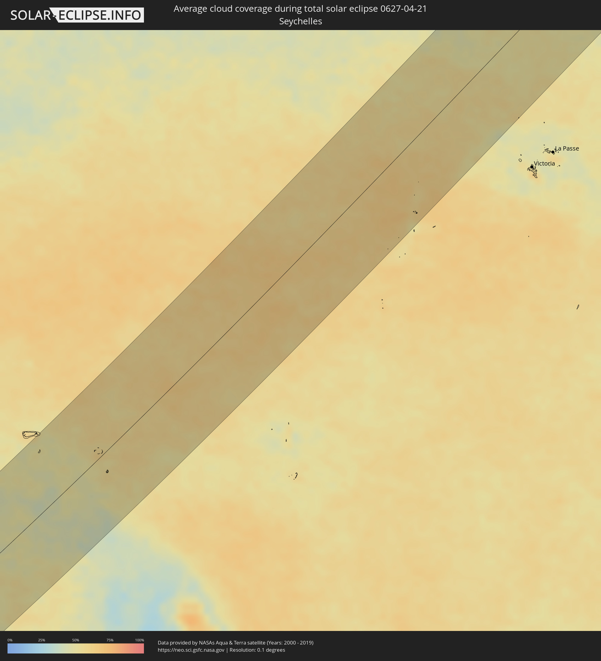 Seychelles
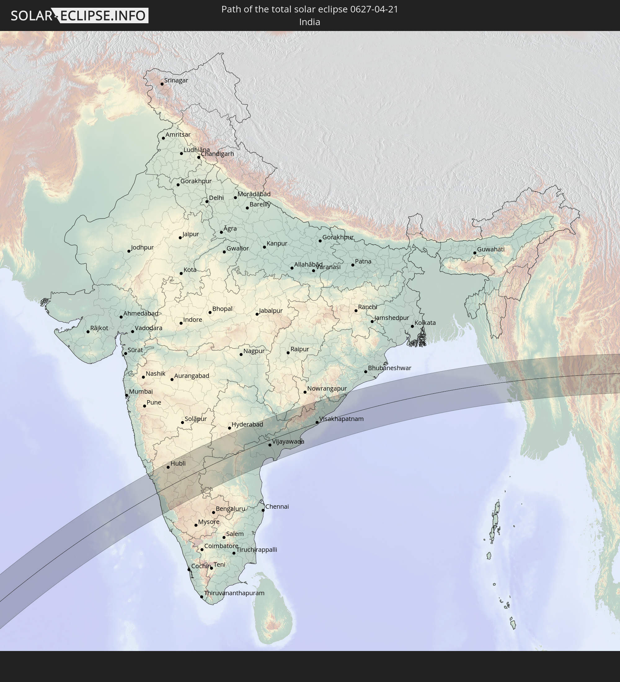
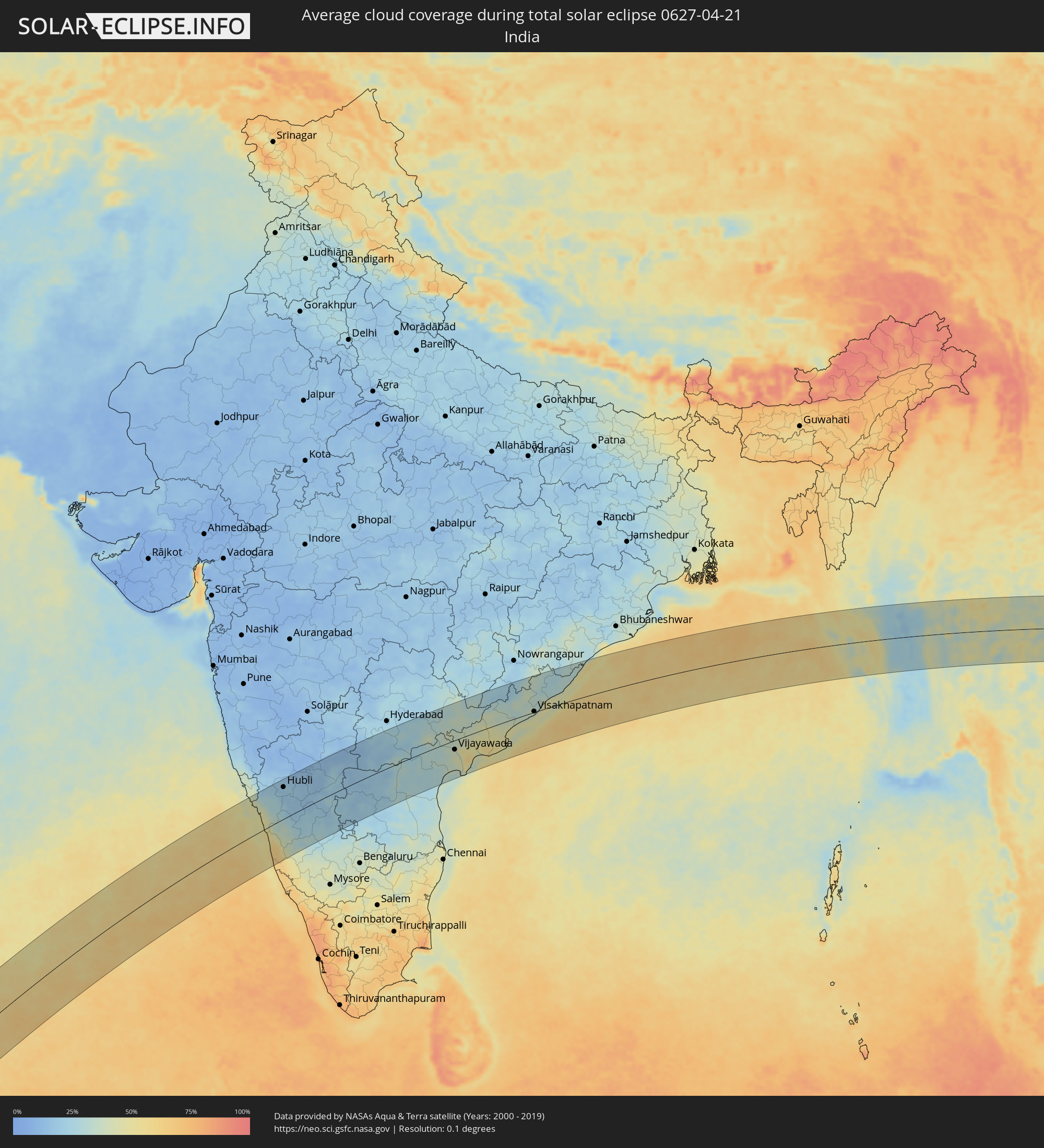 India
India
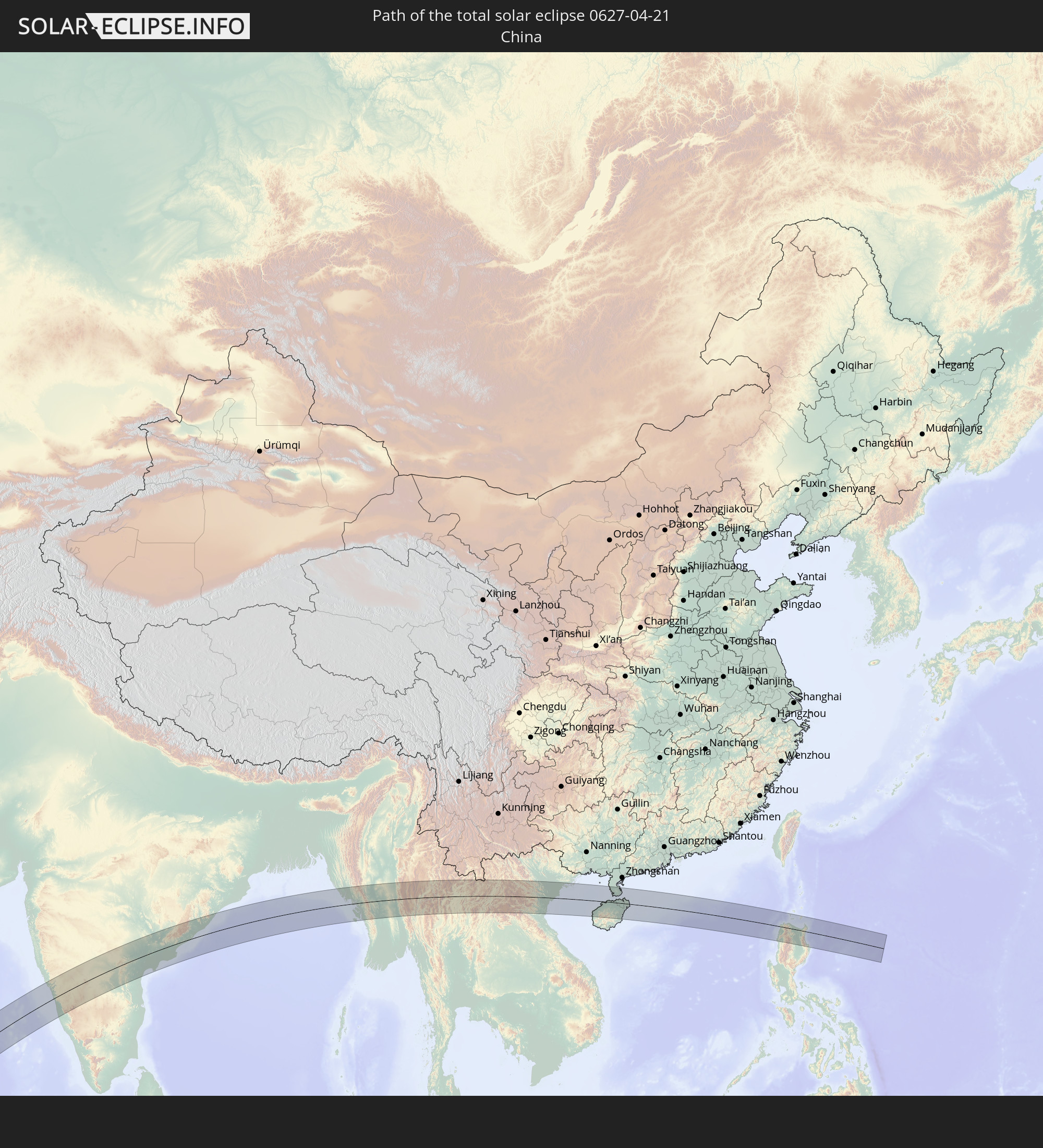
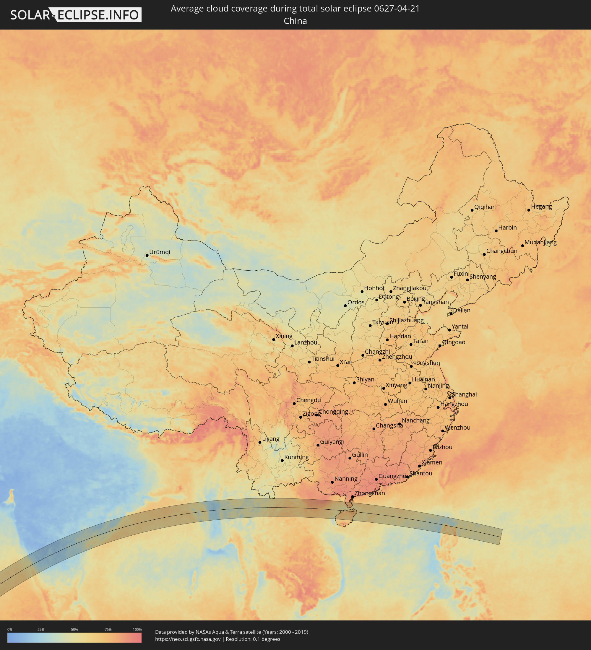 China
China
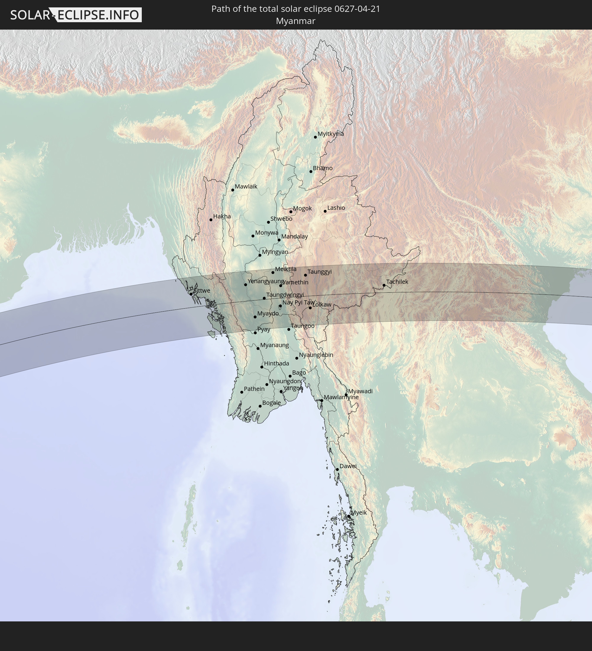
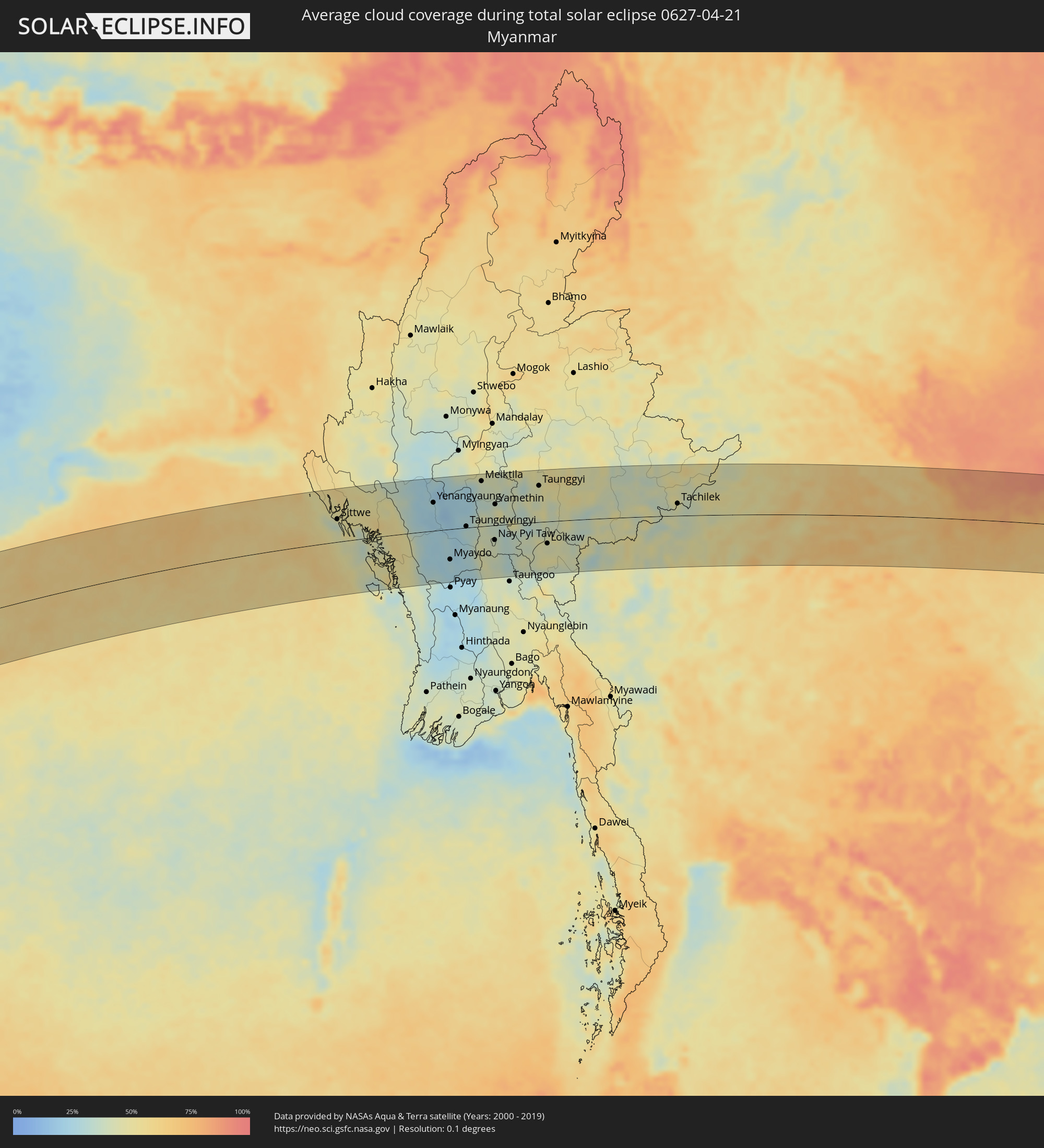 Myanmar
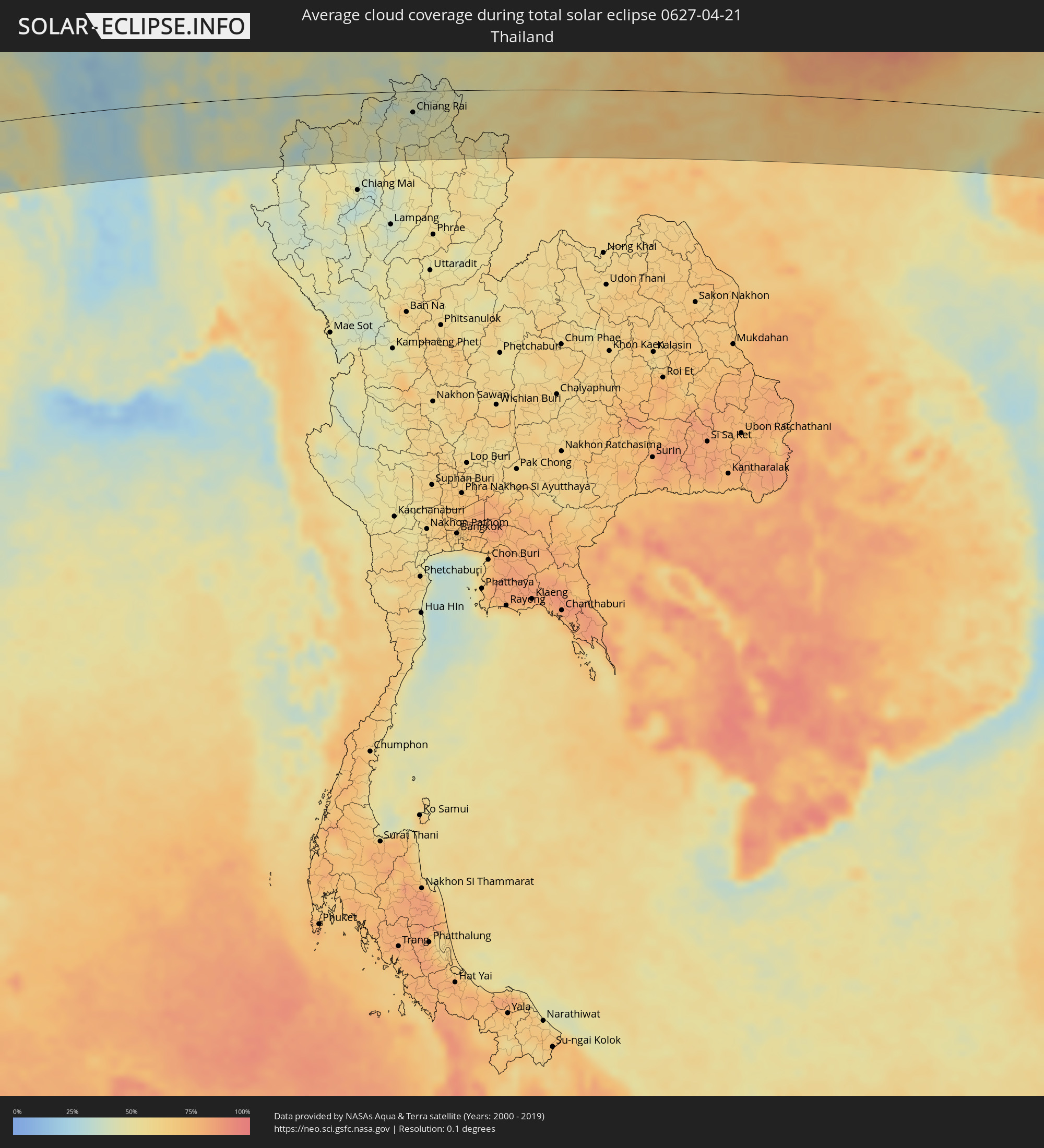 Thailand
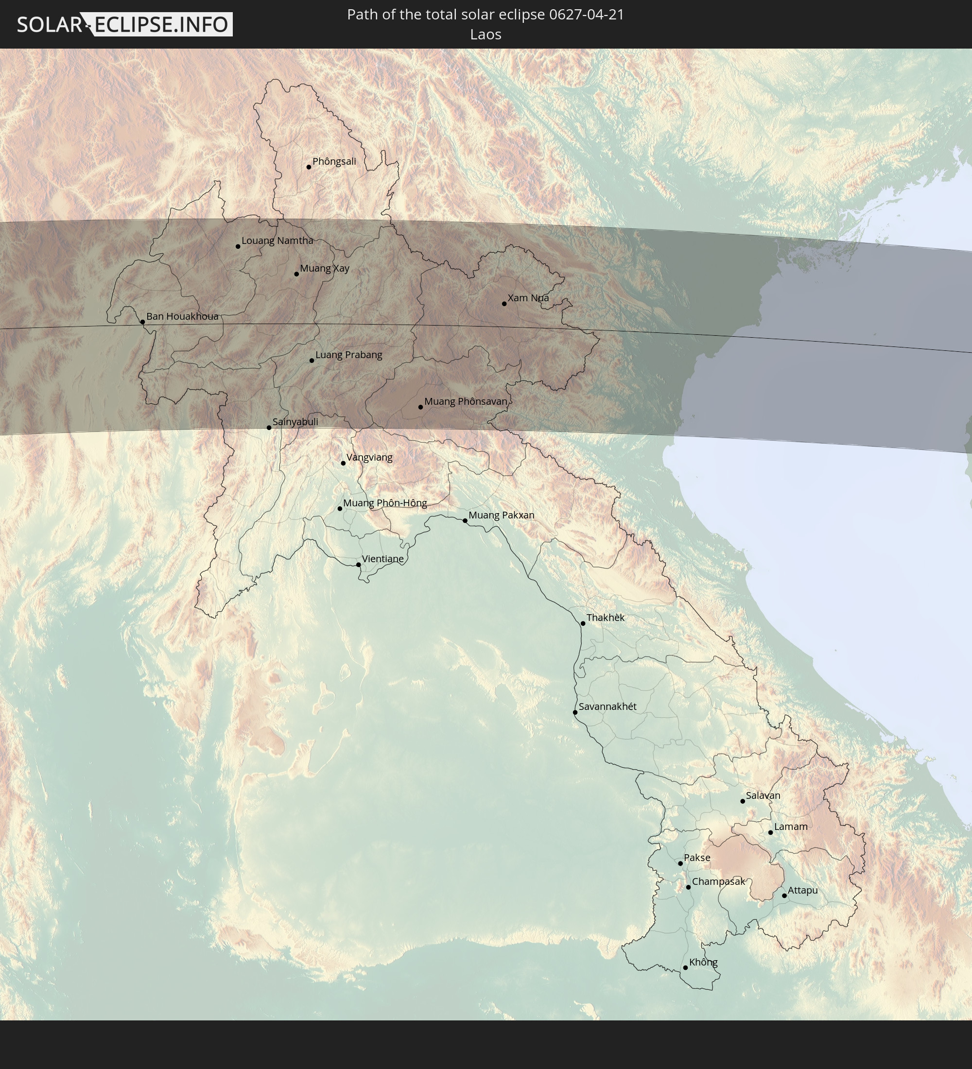
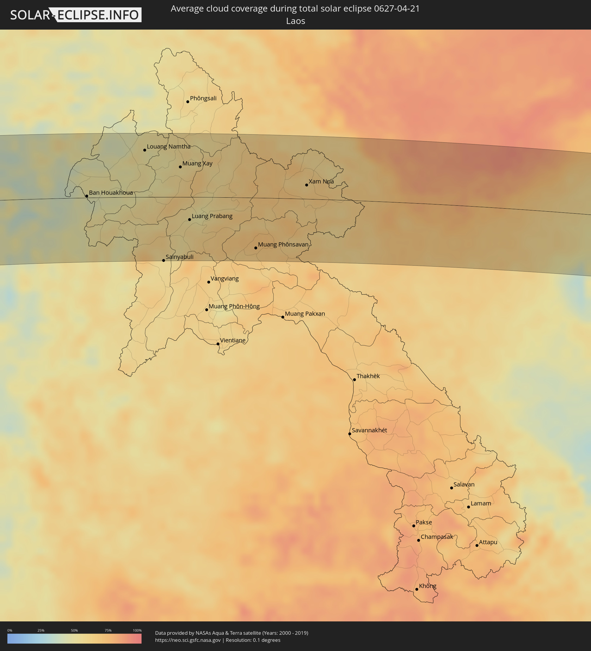 Laos
Laos
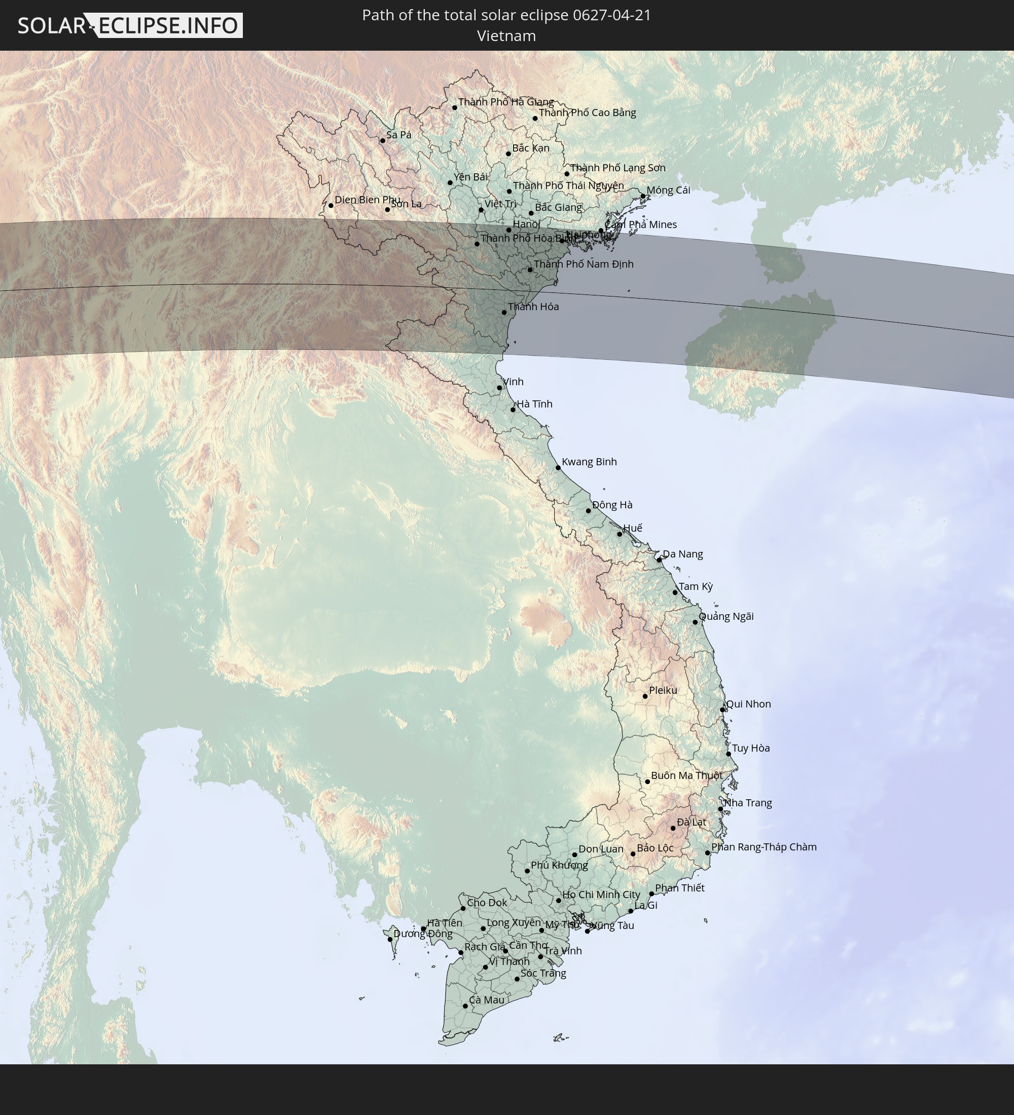
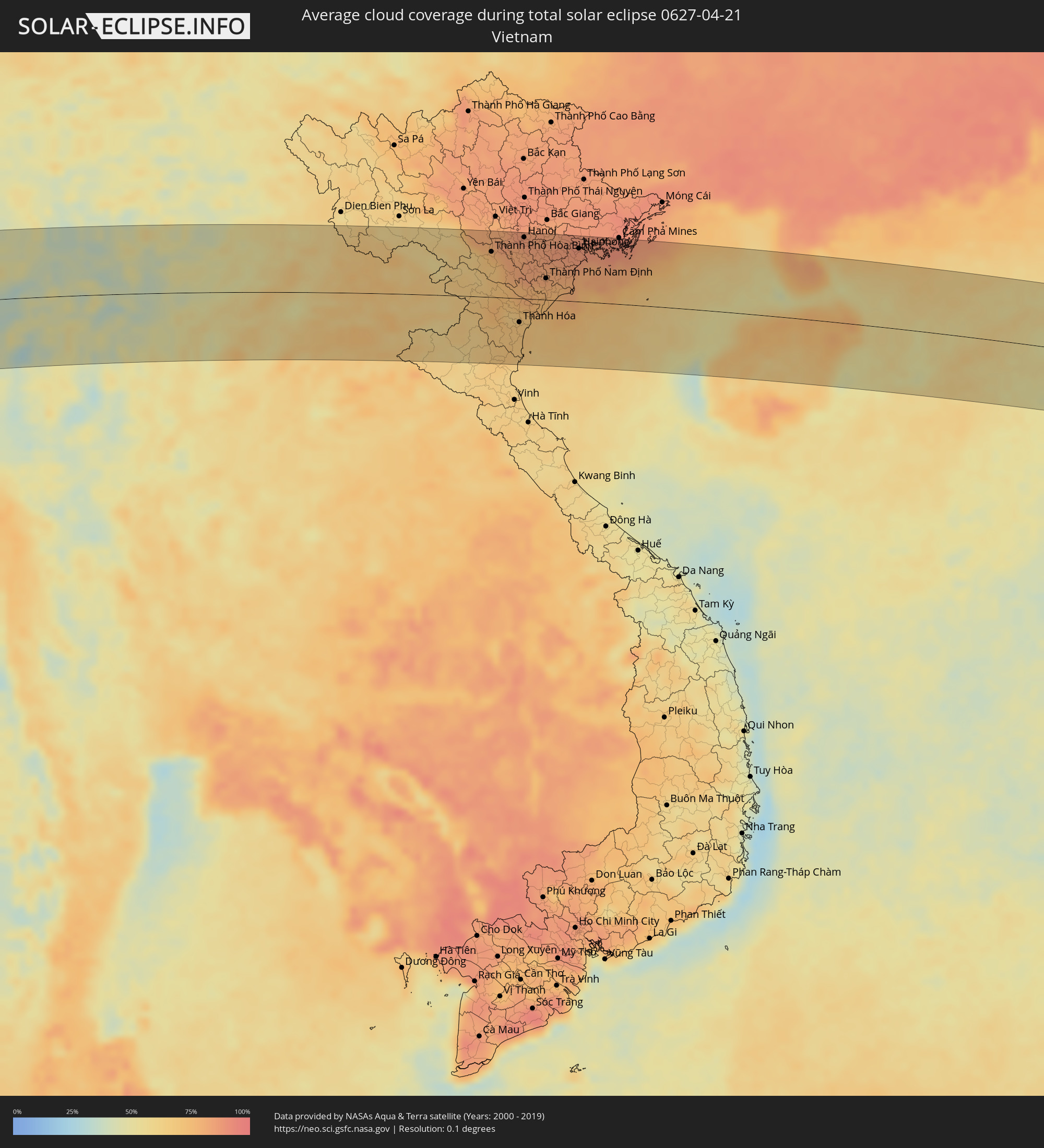 Vietnam
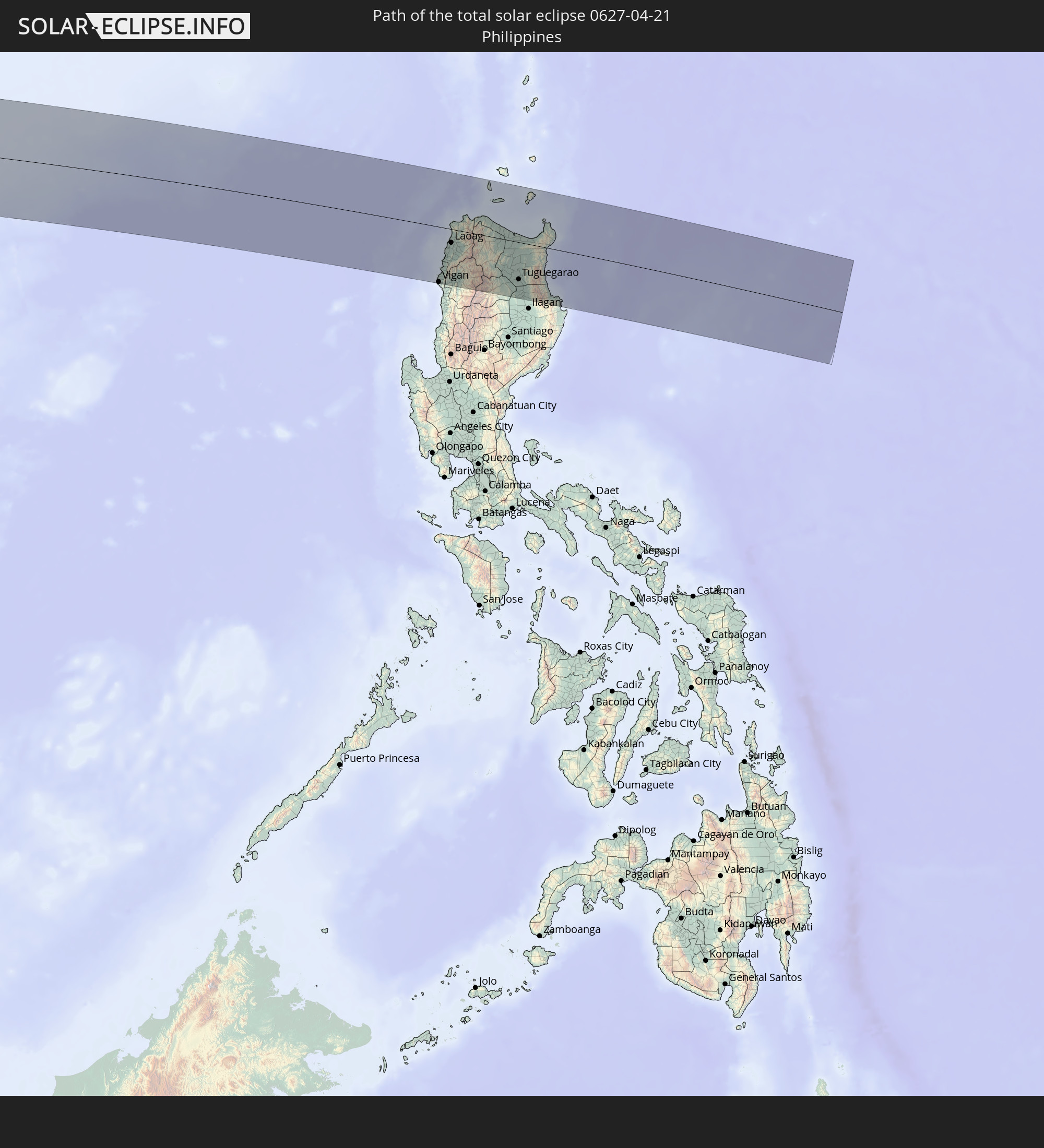
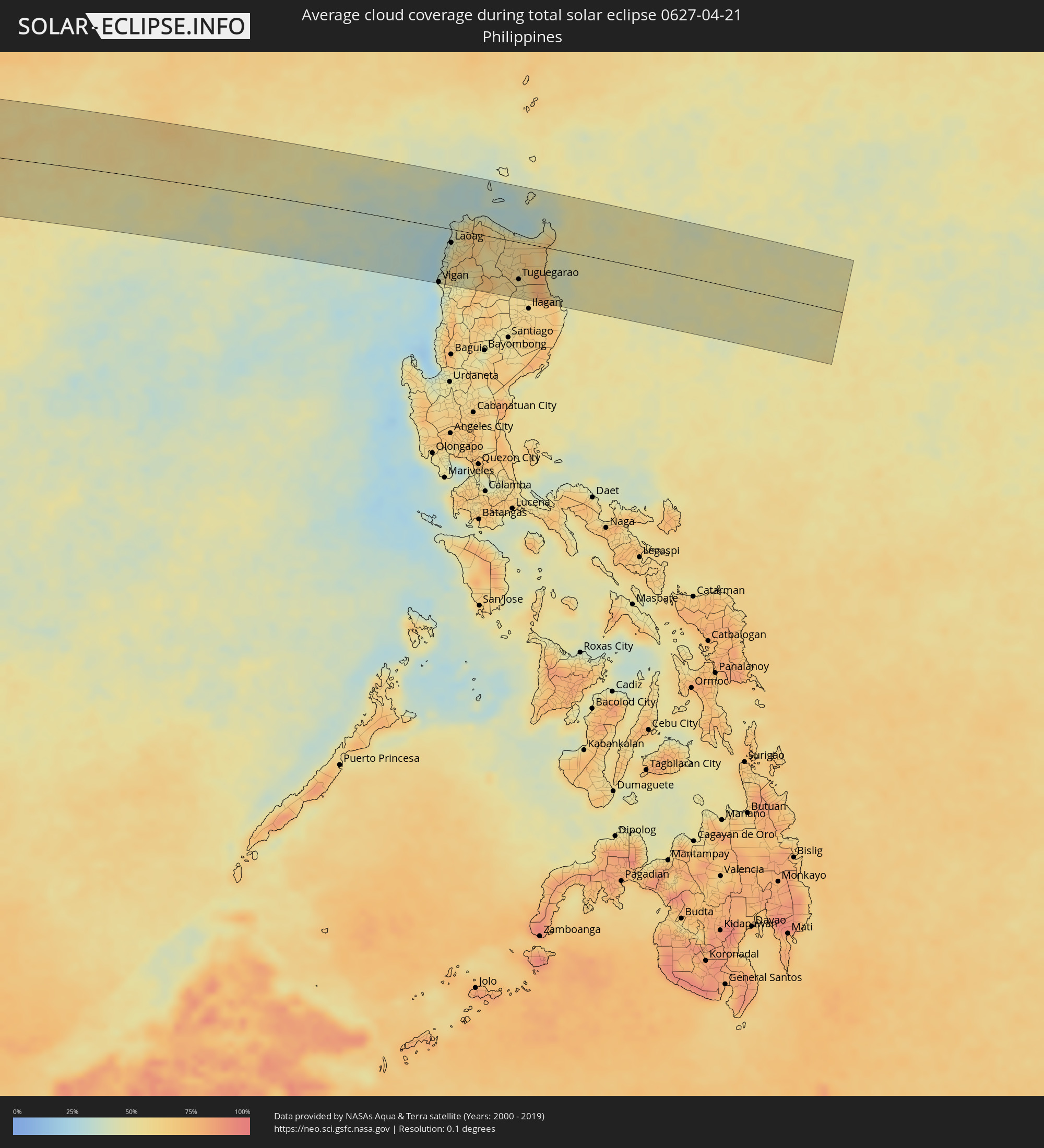 Philippines
Cities inside the path of the eclipse
The following table shows all locations with a population of more than 5,000 inside the eclipse path. Cities which have more than 100,000 inhabitants are marked bold. A click at the locations opens a detailed map.
| City | Type | Eclipse duration | Local time of max. eclipse | Distance to central line | Ø Cloud coverage |
|
Oranjemund, Karas
|
total | - | 07:53:55 UTC+01:30 | 89 km | 47% |
|
Warmbad, Karas
|
total | - | 07:54:52 UTC+01:30 | 10 km | 21% |
|
Karasburg, Karas
|
total | - | 07:54:58 UTC+01:30 | 53 km | 22% |
|
Upington, Northern Cape
|
total | - | 07:56:01 UTC+01:30 | 95 km | 31% |
|
Tshabong, Kgalagadi
|
total | - | 08:37:45 UTC+02:10 | 93 km | 31% |
|
Vryburg, North-West
|
total | - | 07:58:23 UTC+01:30 | 101 km | 36% |
|
Kanye, Ngwaketsi
|
total | - | 08:39:56 UTC+02:10 | 65 km | 35% |
|
Mosopa, Ngwaketsi
|
total | - | 08:40:05 UTC+02:10 | 80 km | 38% |
|
Thamaga, Kweneng
|
total | - | 08:40:13 UTC+02:10 | 84 km | 37% |
|
Janeng, South-East
|
total | - | 08:39:52 UTC+02:10 | 11 km | 37% |
|
Mmabatho, North-West
|
total | - | 07:59:24 UTC+01:30 | 36 km | 39% |
|
Lobatse, South-East
|
total | - | 08:40:03 UTC+02:10 | 23 km | 41% |
|
Otse, South-East
|
total | - | 08:40:11 UTC+02:10 | 41 km | 39% |
|
Gabane, Kweneng
|
total | - | 08:40:23 UTC+02:10 | 72 km | 37% |
|
Metsemotlhaba, Kweneng
|
total | - | 08:40:27 UTC+02:10 | 83 km | 37% |
|
Mogoditshane, Kweneng
|
total | - | 08:40:27 UTC+02:10 | 72 km | 37% |
|
Ramotswa, South-East
|
total | - | 08:40:20 UTC+02:10 | 48 km | 37% |
|
Kopong, South-East
|
total | - | 08:40:32 UTC+02:10 | 85 km | 37% |
|
Gaborone, South-East
|
total | - | 08:40:28 UTC+02:10 | 67 km | 40% |
|
Zeerust, North-West
|
total | - | 07:59:49 UTC+01:30 | 27 km | 45% |
|
Mochudi, Kgatleng
|
total | - | 08:40:45 UTC+02:10 | 79 km | 39% |
|
Lichtenburg, North-West
|
total | - | 07:59:36 UTC+01:30 | 91 km | 41% |
|
Rustenburg, North-West
|
total | - | 08:00:33 UTC+01:30 | 97 km | 45% |
|
Warmbaths, Limpopo
|
total | - | 08:01:40 UTC+01:30 | 74 km | 42% |
|
Modimolle, Limpopo
|
total | - | 08:01:50 UTC+01:30 | 62 km | 43% |
|
Mokopane, Limpopo
|
total | - | 08:02:34 UTC+01:30 | 45 km | 44% |
|
Polokwane, Limpopo
|
total | - | 08:03:05 UTC+01:30 | 42 km | 53% |
|
Lebowakgomo, Limpopo
|
total | - | 08:02:56 UTC+01:30 | 72 km | 43% |
|
Louis Trichardt, Limpopo
|
total | - | 08:03:56 UTC+01:30 | 17 km | 52% |
|
Duiwelskloof, Limpopo
|
total | - | 08:03:44 UTC+01:30 | 58 km | 54% |
|
Nkowakowa, Limpopo
|
total | - | 08:03:44 UTC+01:30 | 84 km | 52% |
|
Thohoyandou, Limpopo
|
total | - | 08:04:28 UTC+01:30 | 6 km | 52% |
|
Giyani, Limpopo
|
total | - | 08:04:26 UTC+01:30 | 52 km | 52% |
|
Dondo, Sofala
|
total | - | 08:51:08 UTC+02:10 | 58 km | 51% |
|
Beira, Sofala
|
total | - | 08:51:01 UTC+02:10 | 31 km | 41% |
|
Quelimane, Zambézia
|
total | - | 08:54:56 UTC+02:10 | 80 km | 52% |
|
António Enes, Nampula
|
total | - | 09:00:05 UTC+02:10 | 26 km | 49% |
|
Ilha de Moçambique, Nampula
|
total | - | 09:02:28 UTC+02:10 | 72 km | 41% |
|
Fomboni, Mohéli
|
total | - | 09:26:50 UTC+02:27 | 90 km | 66% |
|
Sima, Anjouan
|
total | - | 09:27:41 UTC+02:27 | 59 km | 61% |
|
Moutsamoudou, Anjouan
|
total | - | 09:27:54 UTC+02:27 | 52 km | 73% |
|
Mirontsi, Anjouan
|
total | - | 09:27:55 UTC+02:27 | 52 km | 73% |
|
Ouani, Anjouan
|
total | - | 09:27:59 UTC+02:27 | 53 km | 55% |
|
Barakani, Anjouan
|
total | - | 09:27:59 UTC+02:27 | 52 km | 55% |
|
Mkiriwadjumoi
|
total | - | 09:27:45 UTC+02:27 | 38 km | 58% |
|
Moya, Anjouan
|
total | - | 09:27:46 UTC+02:27 | 38 km | 58% |
|
Chandra, Anjouan
|
total | - | 09:27:57 UTC+02:27 | 45 km | 59% |
|
Koni-Djodjo, Anjouan
|
total | - | 09:27:56 UTC+02:27 | 41 km | 59% |
|
Adda-Douéni, Anjouan
|
total | - | 09:27:52 UTC+02:27 | 35 km | 55% |
|
Mramani, Anjouan
|
total | - | 09:27:50 UTC+02:27 | 28 km | 55% |
|
Domoni, Anjouan
|
total | - | 09:27:58 UTC+02:27 | 35 km | 55% |
|
Acoua, Acoua
|
total | - | 09:28:03 UTC+02:27 | 42 km | 56% |
|
Mtsamboro, Mtsamboro
|
total | - | 09:28:06 UTC+02:27 | 41 km | 56% |
|
Bouéni, Bouéni
|
total | - | 09:27:50 UTC+02:27 | 58 km | 54% |
|
M'Tsangamouji, M'Tsangamouji
|
total | - | 09:28:03 UTC+02:27 | 47 km | 58% |
|
Sada, Sada
|
total | - | 09:27:57 UTC+02:27 | 56 km | 54% |
|
Tsingoni, Tsingoni
|
total | - | 09:28:02 UTC+02:27 | 50 km | 58% |
|
Kani Kéli, Kani-Kéli
|
total | - | 09:27:48 UTC+02:27 | 64 km | 48% |
|
Chiconi, Chiconi
|
total | - | 09:27:59 UTC+02:27 | 55 km | 58% |
|
Bandraboua, Bandraboua
|
total | - | 09:28:10 UTC+02:27 | 45 km | 56% |
|
Ouangani, Ouangani
|
total | - | 09:28:00 UTC+02:27 | 58 km | 58% |
|
Chirongui, Chirongui
|
total | - | 09:27:54 UTC+02:27 | 66 km | 54% |
|
Dembeni, Dembeni
|
total | - | 09:28:04 UTC+02:27 | 61 km | 52% |
|
Bandrélé, Bandrele
|
total | - | 09:28:00 UTC+02:27 | 67 km | 51% |
|
Mamoudzou, Mamoudzou
|
total | - | 09:28:13 UTC+02:27 | 59 km | 52% |
|
Dzaoudzi, Dzaoudzi
|
total | - | 09:28:15 UTC+02:27 | 61 km | 45% |
|
Pamandzi, Pamandzi
|
total | - | 09:28:16 UTC+02:27 | 64 km | 45% |
|
Hubli, Karnataka
|
total | - | 14:08:50 UTC+05:21 | 97 km | 20% |
|
Shimoga, Karnataka
|
total | - | 14:07:45 UTC+05:21 | 64 km | 28% |
|
Hospet, Karnataka
|
total | - | 14:11:15 UTC+05:21 | 28 km | 18% |
|
Bellary, Karnataka
|
total | - | 14:12:10 UTC+05:21 | 10 km | 24% |
|
Rāichūr, Karnataka
|
total | - | 14:14:23 UTC+05:21 | 77 km | 17% |
|
Anantapur, Andhra Pradesh
|
total | - | 14:12:56 UTC+05:21 | 88 km | 21% |
|
Ongole, Andhra Pradesh
|
total | - | 14:18:48 UTC+05:21 | 110 km | 28% |
|
Khammam, Telangana
|
total | - | 14:20:58 UTC+05:21 | 66 km | 32% |
|
Guntur, Andhra Pradesh
|
total | - | 14:20:30 UTC+05:21 | 44 km | 37% |
|
Vijayawada, Andhra Pradesh
|
total | - | 14:21:06 UTC+05:21 | 30 km | 38% |
|
Ellore, Andhra Pradesh
|
total | - | 14:22:11 UTC+05:21 | 26 km | 47% |
|
Machilīpatnam, Andhra Pradesh
|
total | - | 14:21:40 UTC+05:21 | 82 km | 52% |
|
Rājahmundry, Andhra Pradesh
|
total | - | 14:23:45 UTC+05:21 | 20 km | 49% |
|
Kākināda, Andhra Pradesh
|
total | - | 14:24:33 UTC+05:21 | 41 km | 46% |
|
Visakhapatnam, Andhra Pradesh
|
total | - | 14:27:00 UTC+05:21 | 2 km | 39% |
|
Vizianagaram, Andhra Pradesh
|
total | - | 14:27:47 UTC+05:21 | 42 km | 36% |
|
Sittwe, Rakhine
|
total | - | 15:47:36 UTC+06:24 | 48 km | 39% |
|
Chauk, Magway
|
total | - | 15:50:25 UTC+06:24 | 109 km | 27% |
|
Yenangyaung, Magway
|
total | - | 15:50:18 UTC+06:24 | 60 km | 25% |
|
Minbu, Magway
|
total | - | 15:50:10 UTC+06:24 | 29 km | 23% |
|
Magway, Magway
|
total | - | 15:50:13 UTC+06:24 | 25 km | 22% |
|
Thayetmyo, Magway
|
total | - | 15:50:09 UTC+06:24 | 70 km | 27% |
|
Myaydo, Magway
|
total | - | 15:50:13 UTC+06:24 | 65 km | 28% |
|
Taungdwingyi, Magway
|
total | - | 15:50:55 UTC+06:24 | 3 km | 31% |
|
Meiktila, Mandalay
|
total | - | 15:51:40 UTC+06:24 | 97 km | 40% |
|
Nay Pyi Taw, Nay Pyi Taw
|
total | - | 15:51:31 UTC+06:24 | 31 km | 41% |
|
Yamethin, Mandalay
|
total | - | 15:51:49 UTC+06:24 | 45 km | 43% |
|
Pyinmana, Nay Pyi Taw
|
total | - | 15:51:36 UTC+06:24 | 33 km | 36% |
|
Taunggyi, Shan
|
total | - | 15:53:00 UTC+06:24 | 78 km | 45% |
|
Loikaw, Kayah
|
total | - | 15:52:46 UTC+06:24 | 47 km | 43% |
|
Mae Hong Son, Mae Hong Son
|
total | - | 16:10:46 UTC+06:42 | 94 km | 37% |
|
Fang, Chiang Mai
|
total | - | 16:12:22 UTC+06:42 | 31 km | 39% |
|
Mae Chai, Phayao
|
total | - | 16:12:48 UTC+06:42 | 96 km | 49% |
|
Chiang Rai, Chiang Rai
|
total | - | 16:13:01 UTC+06:42 | 34 km | 40% |
|
Mae Chan, Chiang Rai
|
total | - | 16:13:07 UTC+06:42 | 7 km | 42% |
|
Mae Sai, Chiang Rai
|
total | - | 16:13:14 UTC+06:42 | 25 km | 40% |
|
Tachilek, Shan
|
total | - | 16:13:15 UTC+06:42 | 26 km | 40% |
|
Pa Daet, Chiang Rai
|
total | - | 16:13:03 UTC+06:42 | 79 km | 49% |
|
Chiang Saen, Chiang Rai
|
total | - | 16:13:24 UTC+06:42 | 6 km | 41% |
|
Chiang Kham, Phayao
|
total | - | 16:13:23 UTC+06:42 | 78 km | 49% |
|
Chiang Khong, Chiang Rai
|
total | - | 16:13:43 UTC+06:42 | 4 km | 45% |
|
Ban Houayxay, Bokeo Province
|
total | - | 16:13:44 UTC+06:42 | 6 km | 45% |
|
Ban Houakhoua, Bokeo Province
|
total | - | 16:13:46 UTC+06:42 | 2 km | 43% |
|
Chiang Klang, Nan
|
total | - | 16:13:52 UTC+06:42 | 104 km | 48% |
|
Louang Namtha, Loungnamtha
|
total | - | 16:14:54 UTC+06:42 | 79 km | 53% |
|
Muang Xay, Oudômxai
|
total | - | 16:15:23 UTC+06:42 | 51 km | 58% |
|
Luang Prabang, Louangphabang
|
total | - | 16:15:18 UTC+06:42 | 39 km | 56% |
|
Muang Phônsavan, Xiangkhoang
|
total | - | 16:16:10 UTC+06:42 | 86 km | 64% |
|
Xam Nua, Houaphan
|
total | - | 16:17:09 UTC+06:42 | 23 km | 66% |
|
Thành Phố Hòa Bình, Hòa Bình
|
total | - | 16:42:53 UTC+07:06 | 73 km | 72% |
|
Thanh Hóa, Thanh Hóa
|
total | - | 16:43:00 UTC+07:06 | 38 km | 69% |
|
Hà Đông, Ha Nội
|
total | - | 16:43:15 UTC+07:06 | 92 km | 83% |
|
Hanoi, Ha Nội
|
total | - | 16:43:18 UTC+07:06 | 98 km | 83% |
|
Bỉm Sơn, Thanh Hóa
|
total | - | 16:43:08 UTC+07:06 | 7 km | 75% |
|
Thành Phố Phủ Lý, Hà Nam
|
total | - | 16:43:16 UTC+07:06 | 45 km | 83% |
|
Thành Phố Ninh Bình, Ninh Bình
|
total | - | 16:43:16 UTC+07:06 | 14 km | 76% |
|
Hưng Yên, Hưng Yên
|
total | - | 16:43:24 UTC+07:06 | 57 km | 81% |
|
Thành Phố Nam Định, Nam Định
|
total | - | 16:43:27 UTC+07:06 | 34 km | 78% |
|
Thành Phố Hải Dương, Hải Dương
|
total | - | 16:43:40 UTC+07:06 | 92 km | 86% |
|
Thành Phố Thái Bình, Thái Bình
|
total | - | 16:43:35 UTC+07:06 | 37 km | 79% |
|
Haiphong, Hải Phòng
|
total | - | 16:43:54 UTC+07:06 | 85 km | 87% |
|
Thành Phố Uông Bí, Quảng Ninh
|
total | - | 16:44:00 UTC+07:06 | 105 km | 87% |
|
Cát Bà, Hải Phòng
|
total | - | 16:44:09 UTC+07:06 | 72 km | 82% |
|
Thành Phố Hạ Long, Quảng Ninh
|
total | - | 16:44:12 UTC+07:06 | 97 km | 90% |
|
Lincheng, Hainan
|
total | - | 17:39:06 UTC+08:00 | 2 km | 74% |
|
Jinjiang, Hainan
|
total | - | 17:39:17 UTC+08:00 | 14 km | 68% |
|
Xucheng, Guangdong
|
total | - | 17:39:28 UTC+08:00 | 54 km | 60% |
|
Xiuying, Hainan
|
total | - | 17:39:29 UTC+08:00 | 19 km | 75% |
|
Haikou, Hainan
|
total | - | 17:39:32 UTC+08:00 | 24 km | 75% |
|
Qiongshan, Hainan
|
total | - | 17:39:32 UTC+08:00 | 20 km | 74% |
|
Vigan, Ilocos
|
total | - | 17:43:21 UTC+08:00 | 96 km | 43% |
|
Cabugao, Ilocos
|
total | - | 17:43:24 UTC+08:00 | 71 km | 58% |
|
Batac City, Ilocos
|
total | - | 17:43:27 UTC+08:00 | 40 km | 52% |
|
Laoag, Ilocos
|
total | - | 17:43:28 UTC+08:00 | 24 km | 45% |
|
Dingras, Ilocos
|
total | - | 17:43:29 UTC+08:00 | 32 km | 59% |
|
Claveria, Cagayan Valley
|
total | - | 17:43:36 UTC+08:00 | 31 km | 51% |
|
Tabuk, Cordillera
|
total | - | 17:43:35 UTC+08:00 | 85 km | 56% |
|
Cabaritan East, Cagayan Valley
|
total | - | 17:43:40 UTC+08:00 | 18 km | 51% |
|
Lasam, Cagayan Valley
|
total | - | 17:43:40 UTC+08:00 | 18 km | 59% |
|
Aparri, Cagayan Valley
|
total | - | 17:43:42 UTC+08:00 | 15 km | 45% |
|
Magapit, Aguiguican, Cagayan Valley
|
total | - | 17:43:41 UTC+08:00 | 12 km | 63% |
|
Bauan, Cagayan Valley
|
total | - | 17:43:39 UTC+08:00 | 54 km | 56% |
|
Atulayan, Cagayan Valley
|
total | - | 17:43:39 UTC+08:00 | 60 km | 56% |
|
Tuguegarao, Cagayan Valley
|
total | - | 17:43:39 UTC+08:00 | 64 km | 55% |
|
Cabagan, Cagayan Valley
|
total | - | 17:43:38 UTC+08:00 | 84 km | 54% |
|
Gonzaga, Cagayan Valley
|
total | - | 17:43:45 UTC+08:00 | 11 km | 51% |