Annular solar eclipse of 02/17/0649
| Day of week: | Saturday |
| Maximum duration of eclipse: | 06m05s |
| Maximum width of eclipse path: | 201 km |
| Saros cycle: | 89 |
| Coverage: | 94.6% |
| Magnitude: | 0.9455 |
| Gamma: | -0.0499 |
Wo kann man die Sonnenfinsternis vom 02/17/0649 sehen?
Die Sonnenfinsternis am 02/17/0649 kann man in 74 Ländern als partielle Sonnenfinsternis beobachten.
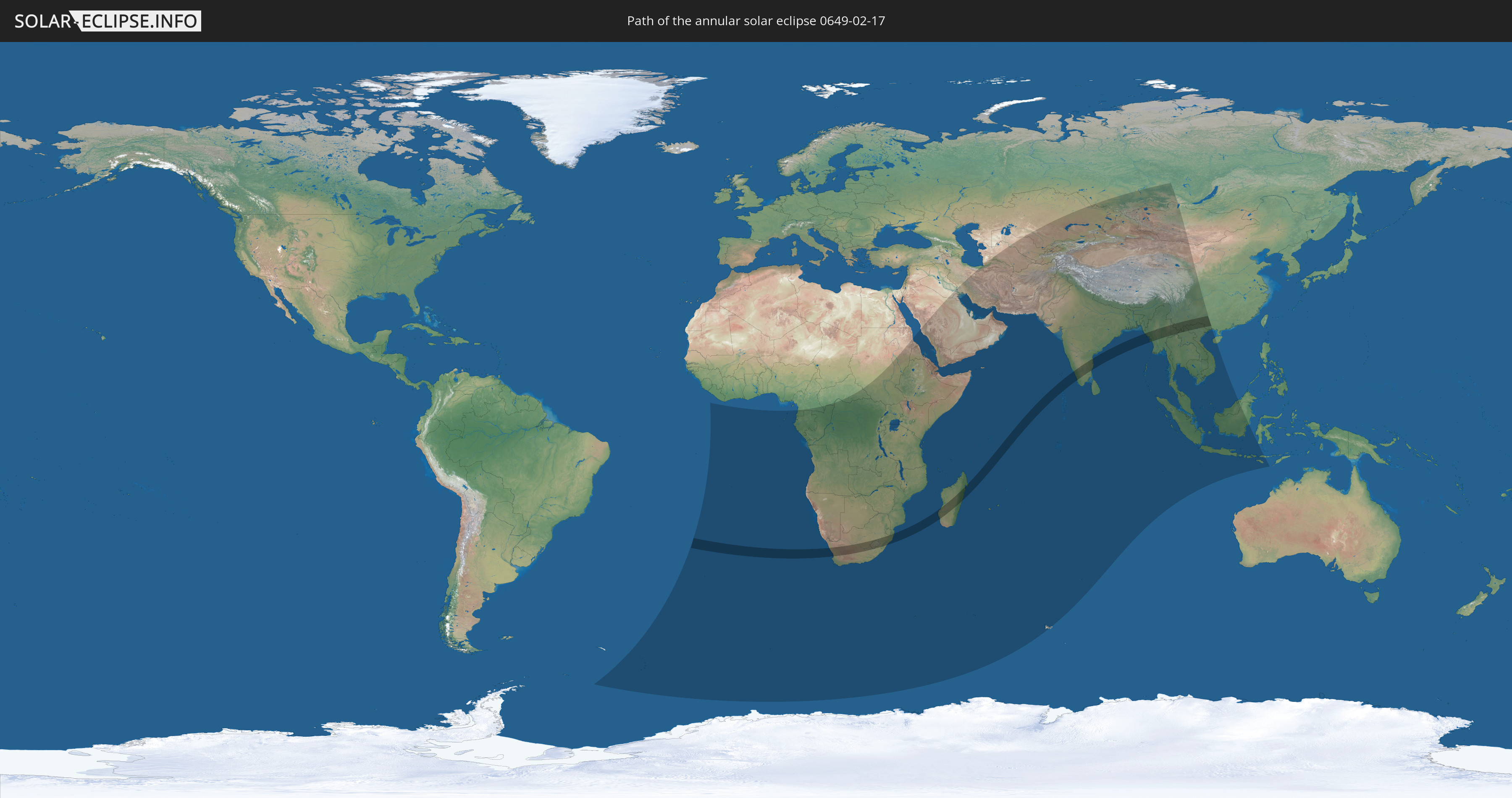
Der Finsternispfad verläuft durch 10 Länder. Nur in diesen Ländern ist sie als annular Sonnenfinsternis zu sehen.
In den folgenden Ländern ist die Sonnenfinsternis annular zu sehen
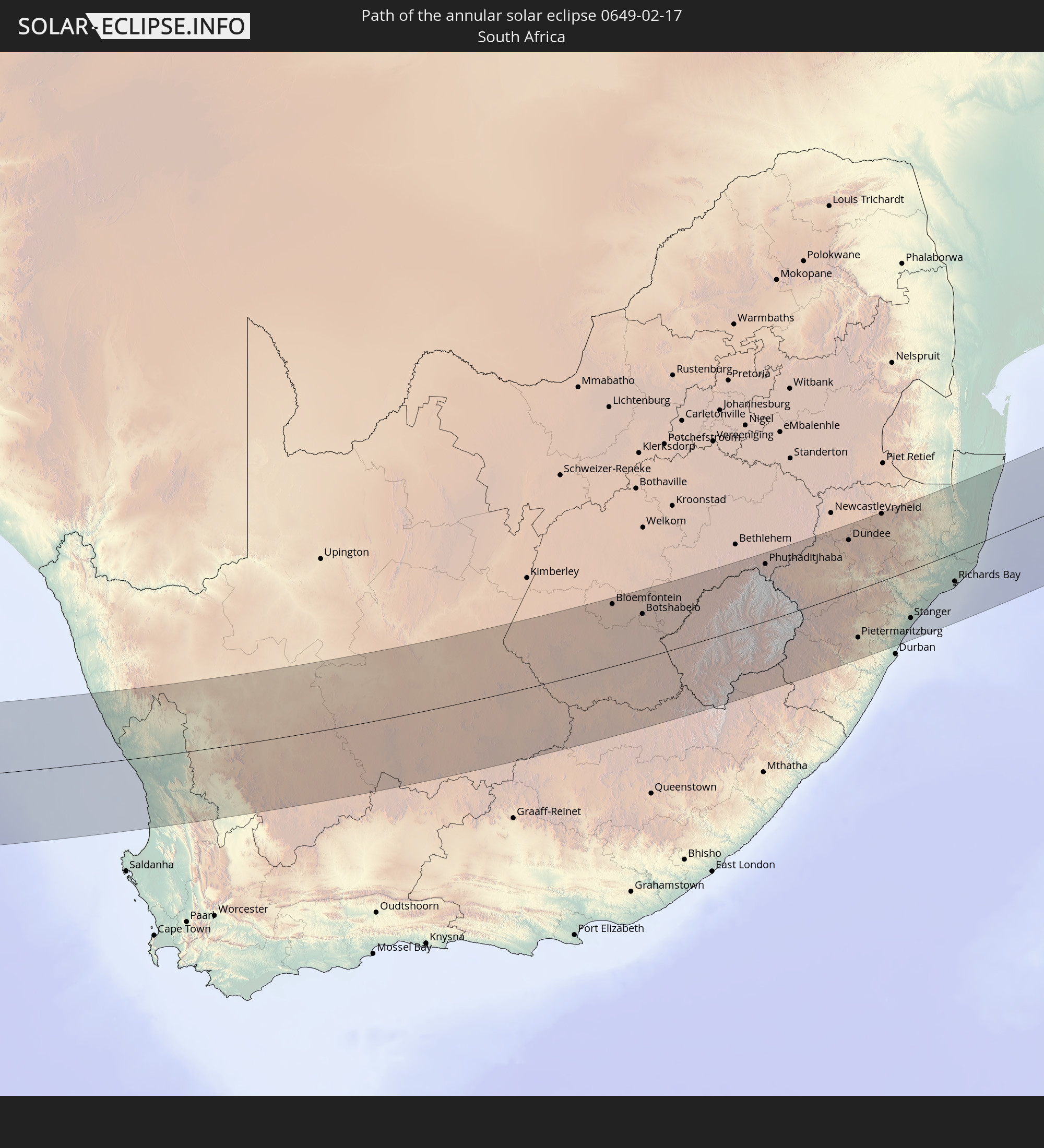 South Africa
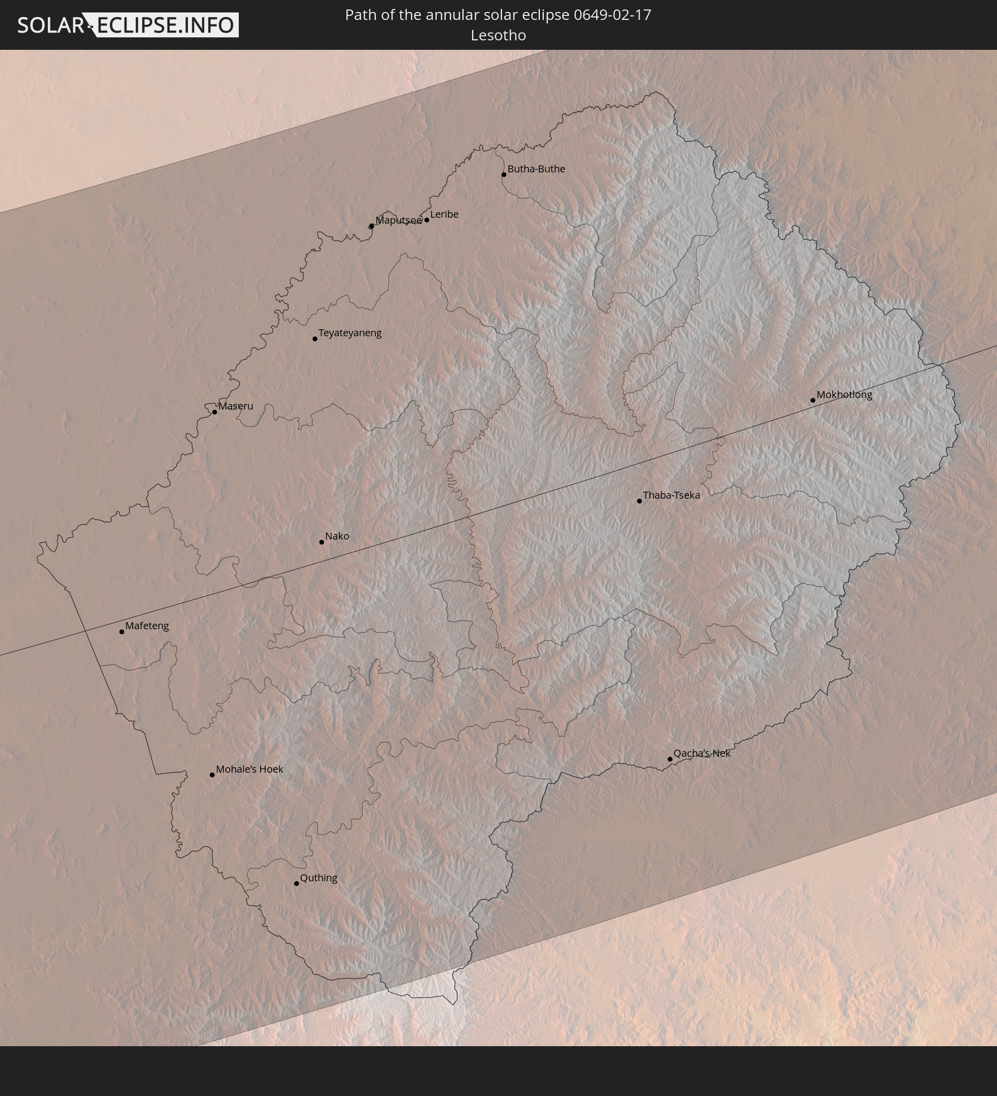 Lesotho
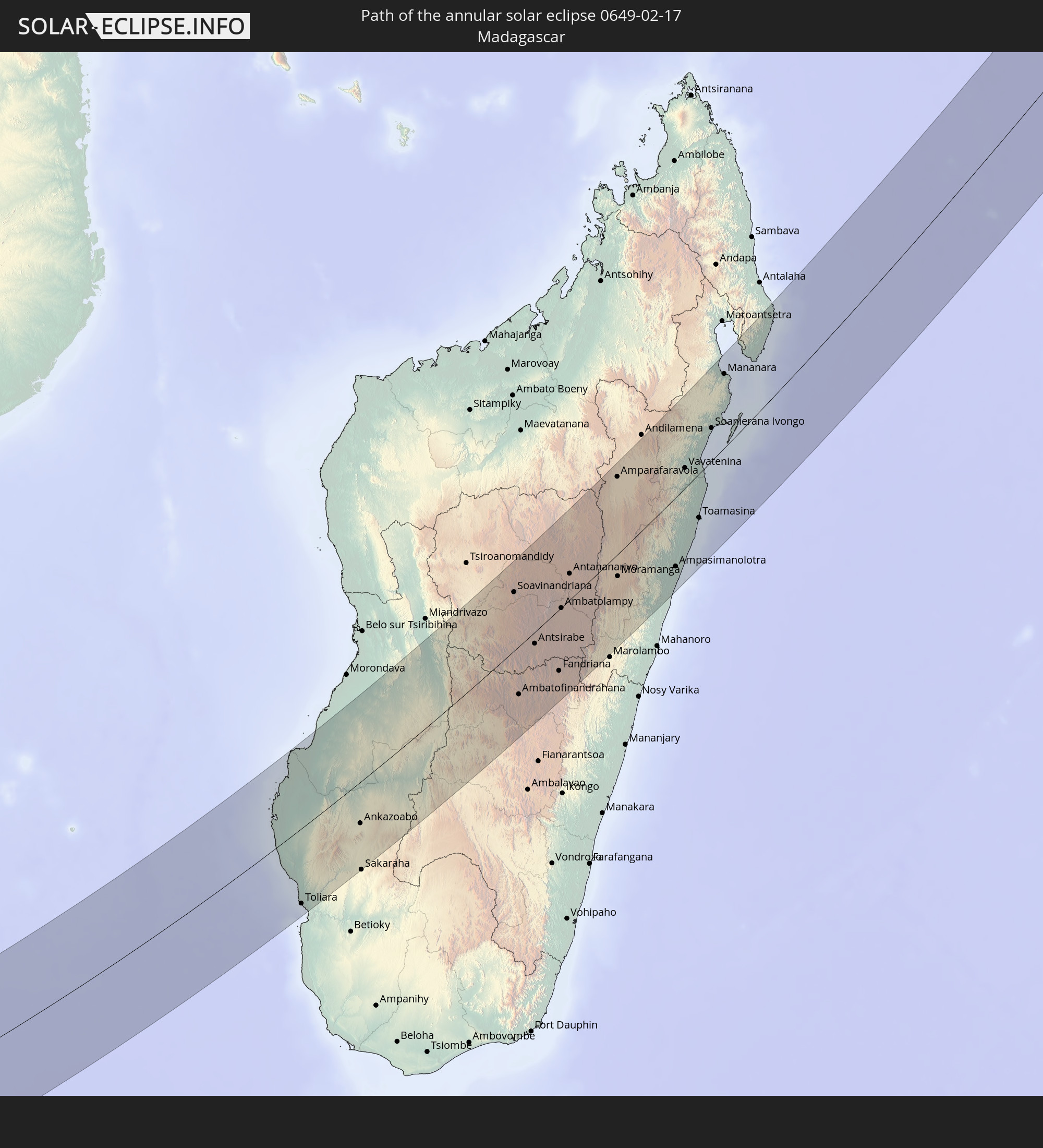 Madagascar
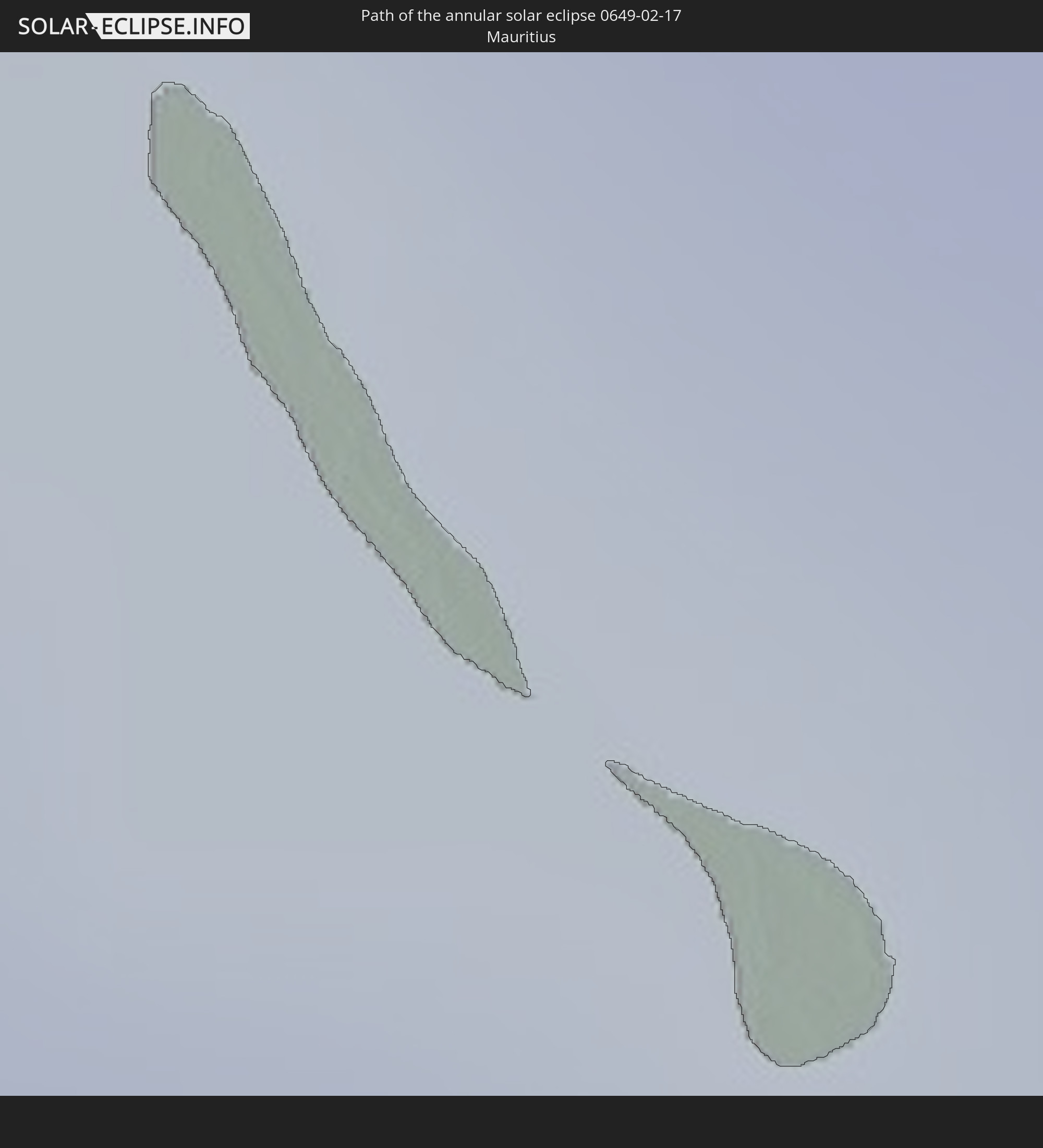 Mauritius
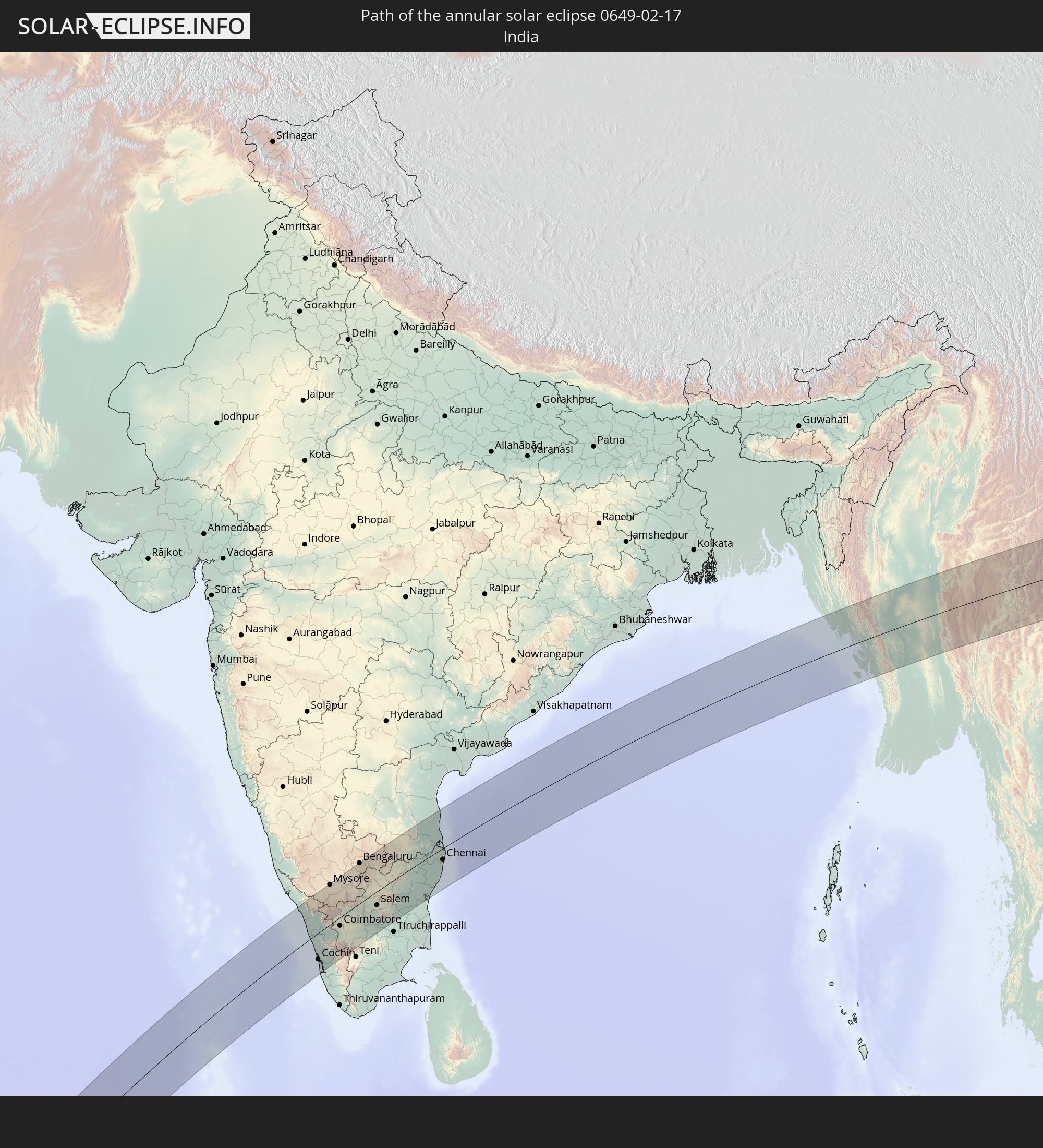 India
India
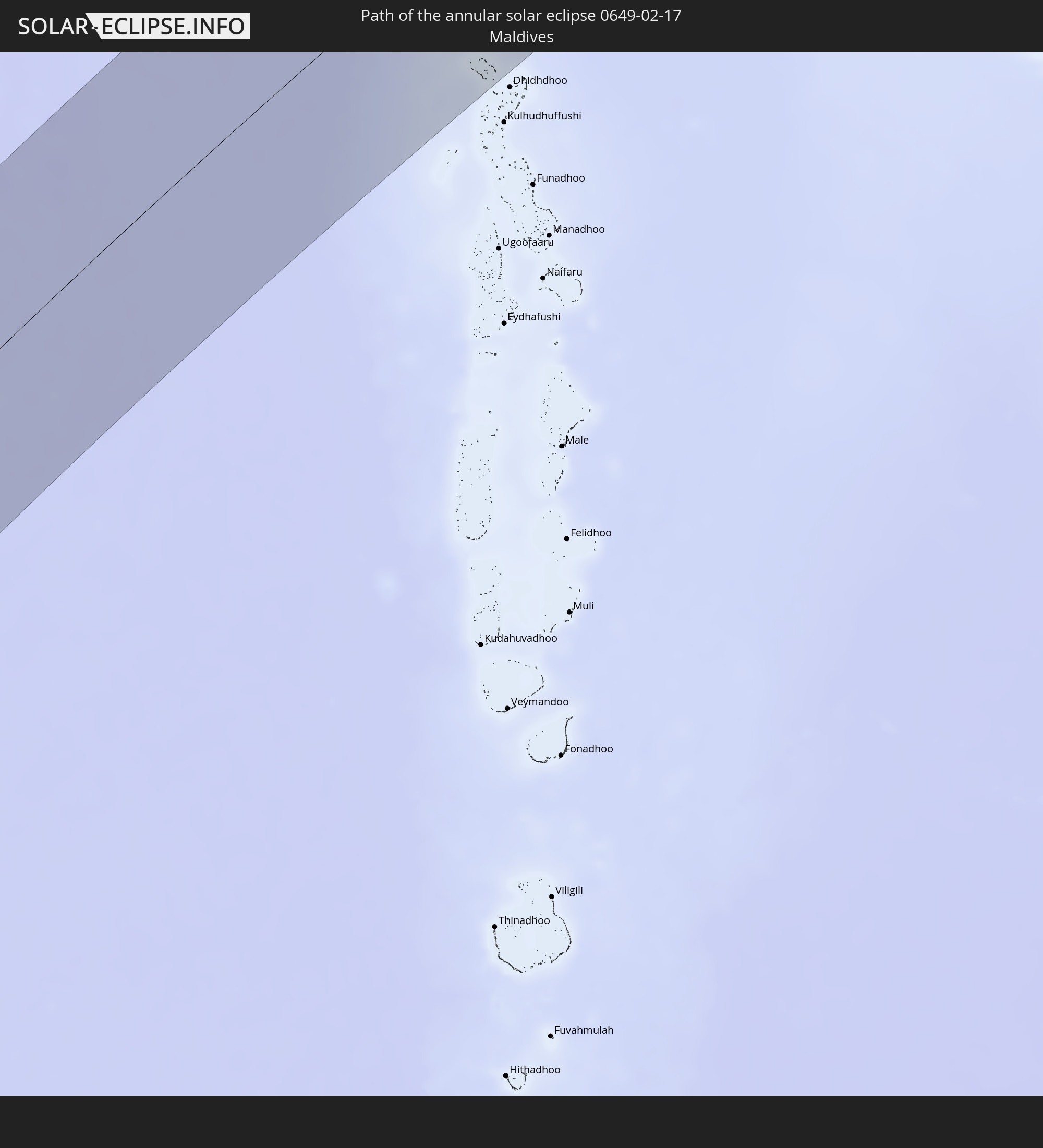 Maldives
 China
China
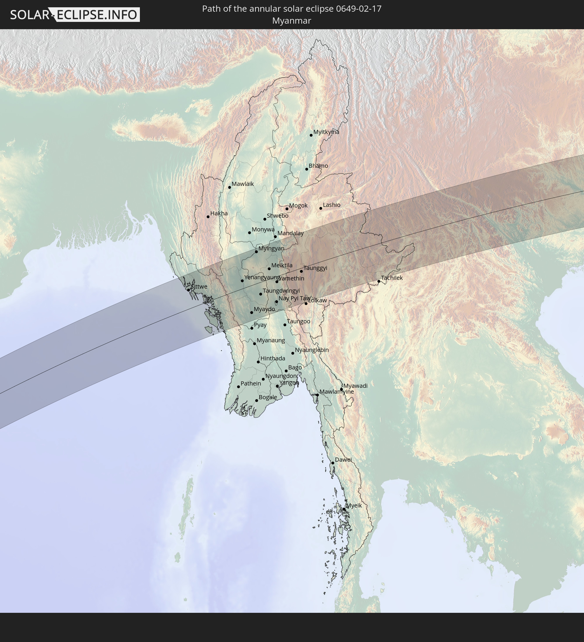 Myanmar
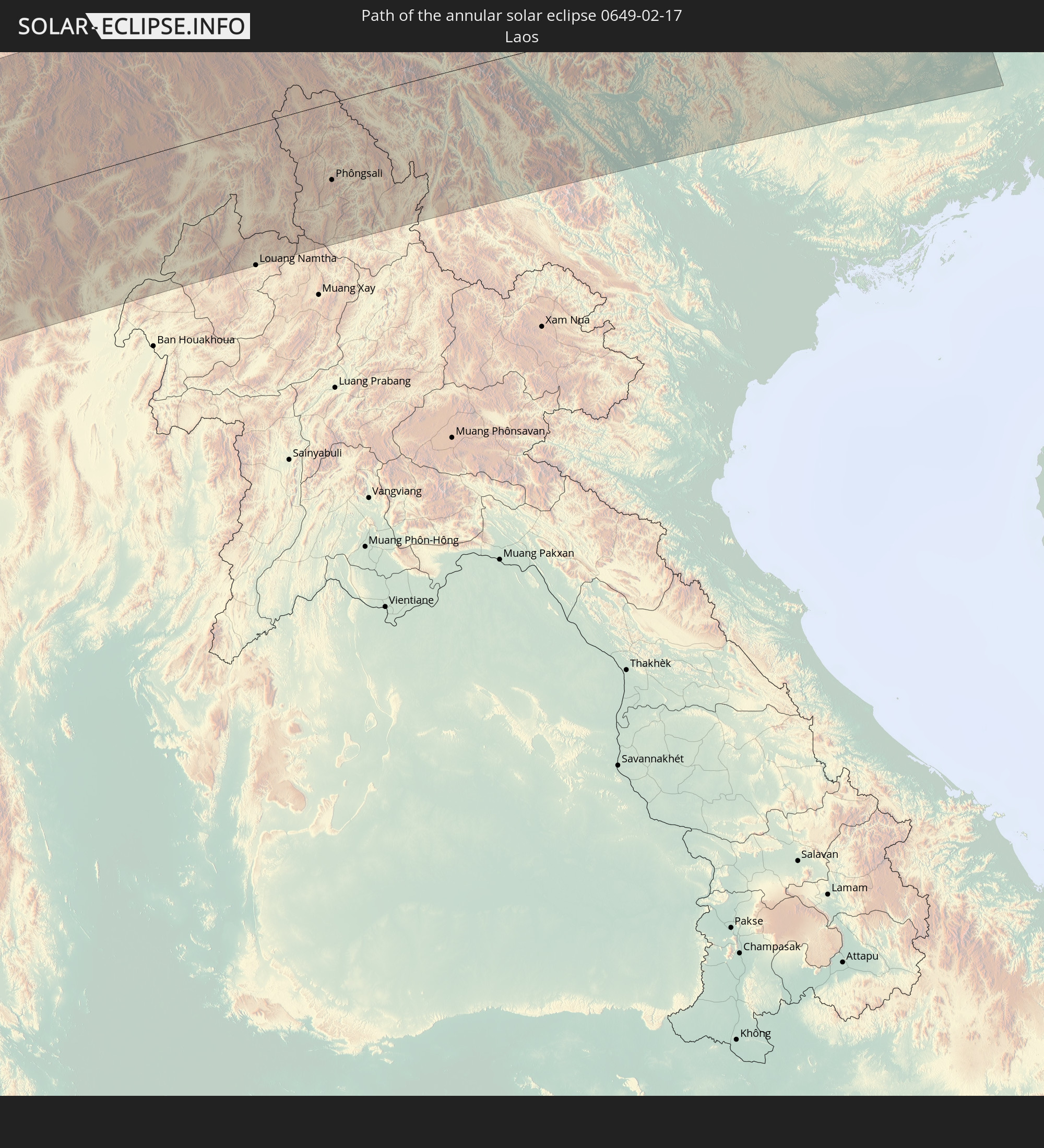 Laos
Laos
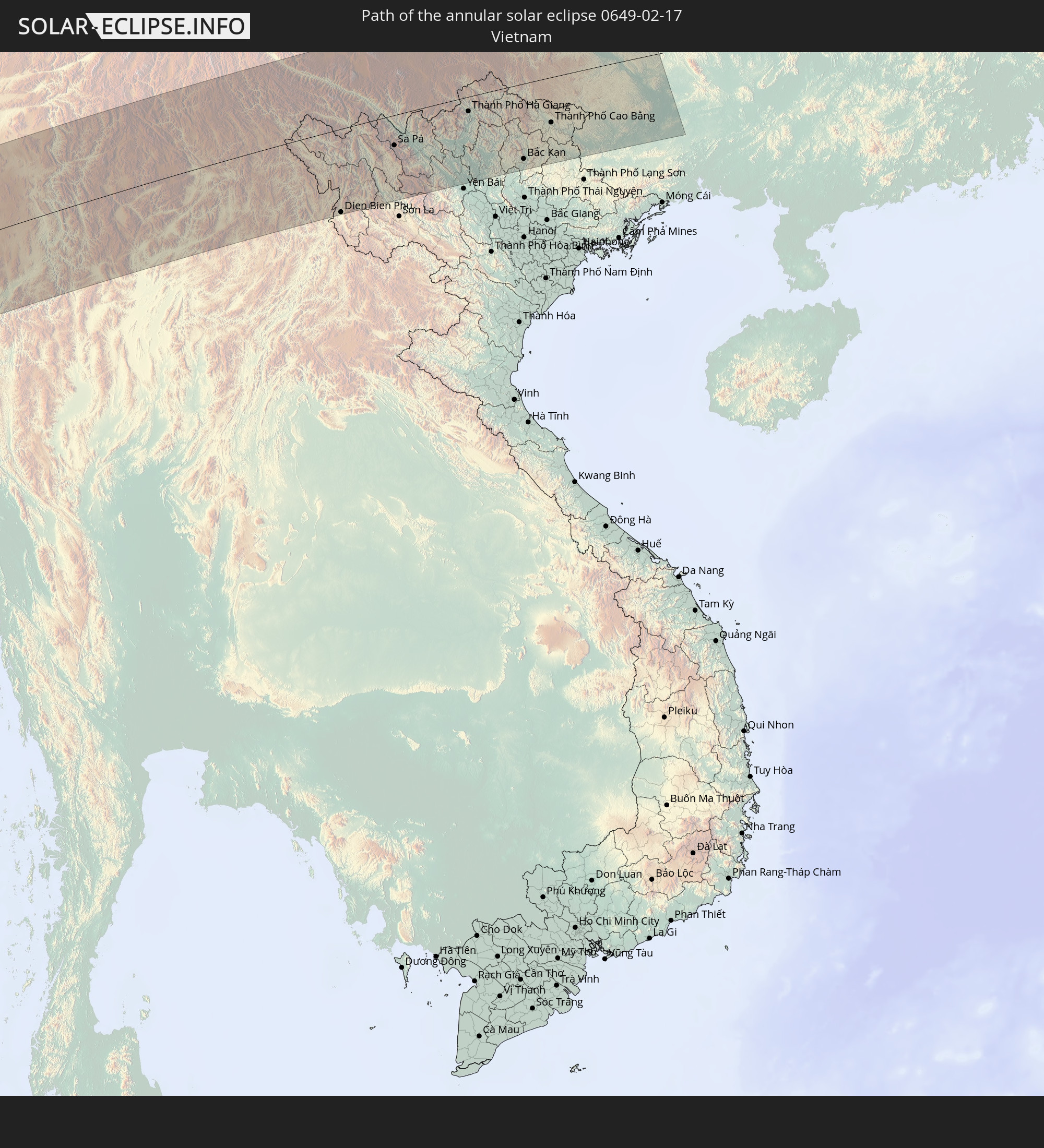 Vietnam
In den folgenden Ländern ist die Sonnenfinsternis partiell zu sehen
 Russia
 South Georgia and the South Sandwich Islands
 Saint Helena, Ascension and Tristan da Cunha
 Bouvet Island
 Equatorial Guinea
 São Tomé and Príncipe
 Cameroon
 Gabon
Gabon
 Republic of the Congo
 Angola
 Namibia
 Democratic Republic of the Congo
 Central African Republic
 South Africa
 Botswana
 Sudan
Sudan
 Zambia
 Zimbabwe
 Lesotho
 Rwanda
 Burundi
 Tanzania
 Uganda
 Mozambique
 Swaziland
 Malawi
 Ethiopia
 Kenya
Kenya
 Saudi Arabia
 Eritrea
 Iraq
Iraq
 French Southern and Antarctic Lands
 Somalia
 Djibouti
 Yemen
Yemen
 Madagascar
 Comoros
 Iran
Iran
 Mayotte
 Seychelles
 Kazakhstan
 Kuwait
 Bahrain
 Qatar
Qatar
 United Arab Emirates
 Oman
Oman
 Turkmenistan
 Réunion
 Uzbekistan
 Mauritius
 Afghanistan
 Pakistan
 Tajikistan
 India
India
 Kyrgyzstan
 British Indian Ocean Territory
 Maldives
 China
China
 Sri Lanka
 Nepal
Nepal
 Mongolia
 Bangladesh
 Bhutan
 Myanmar
 Indonesia
 Cocos Islands
 Thailand
 Malaysia
 Laos
Laos
 Vietnam
 Cambodia
 Singapore
 Christmas Island
 Brunei
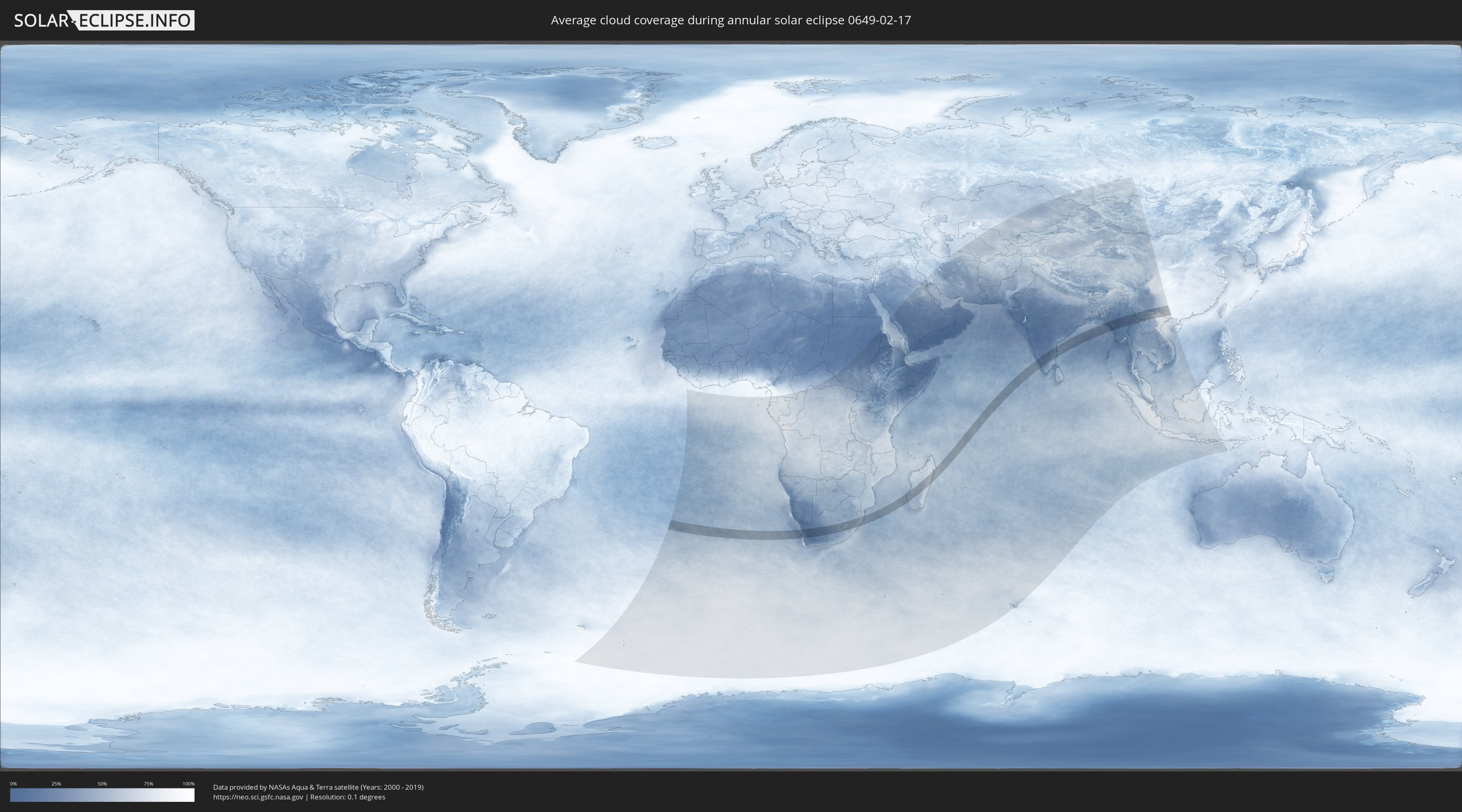
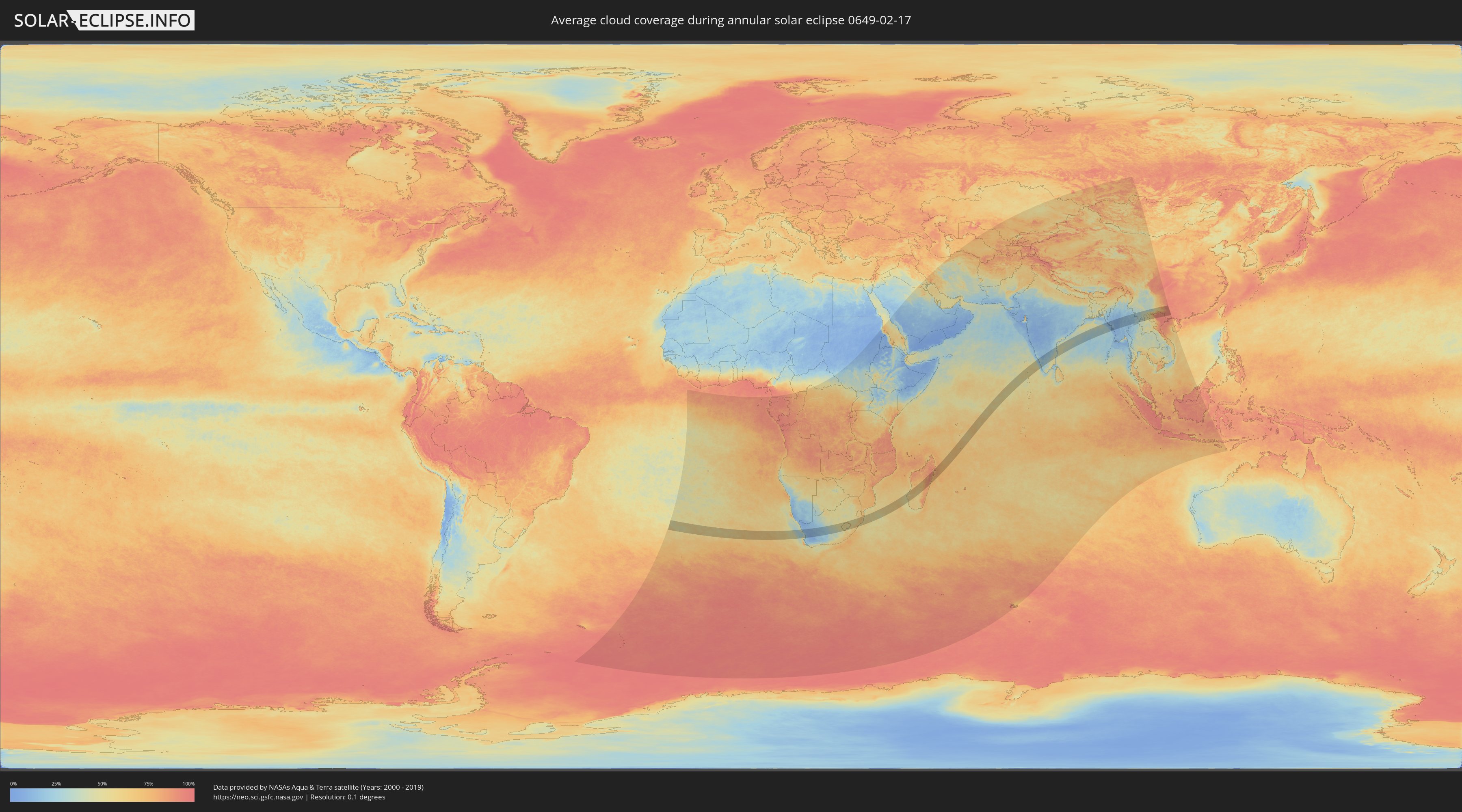
How will be the weather during the annular solar eclipse on 02/17/0649?
Where is the best place to see the annular solar eclipse of 02/17/0649?
The following maps show the average cloud coverage for the day of the annular solar eclipse.
With the help of these maps, it is possible to find the place along the eclipse path, which has the best
chance of a cloudless sky.
Nevertheless, you should consider local circumstances and inform about the weather of your chosen
observation site.
The data is provided by NASAs satellites
AQUA and TERRA.
The cloud maps are averaged over a period of 19 years (2000 - 2019).
Detailed country maps
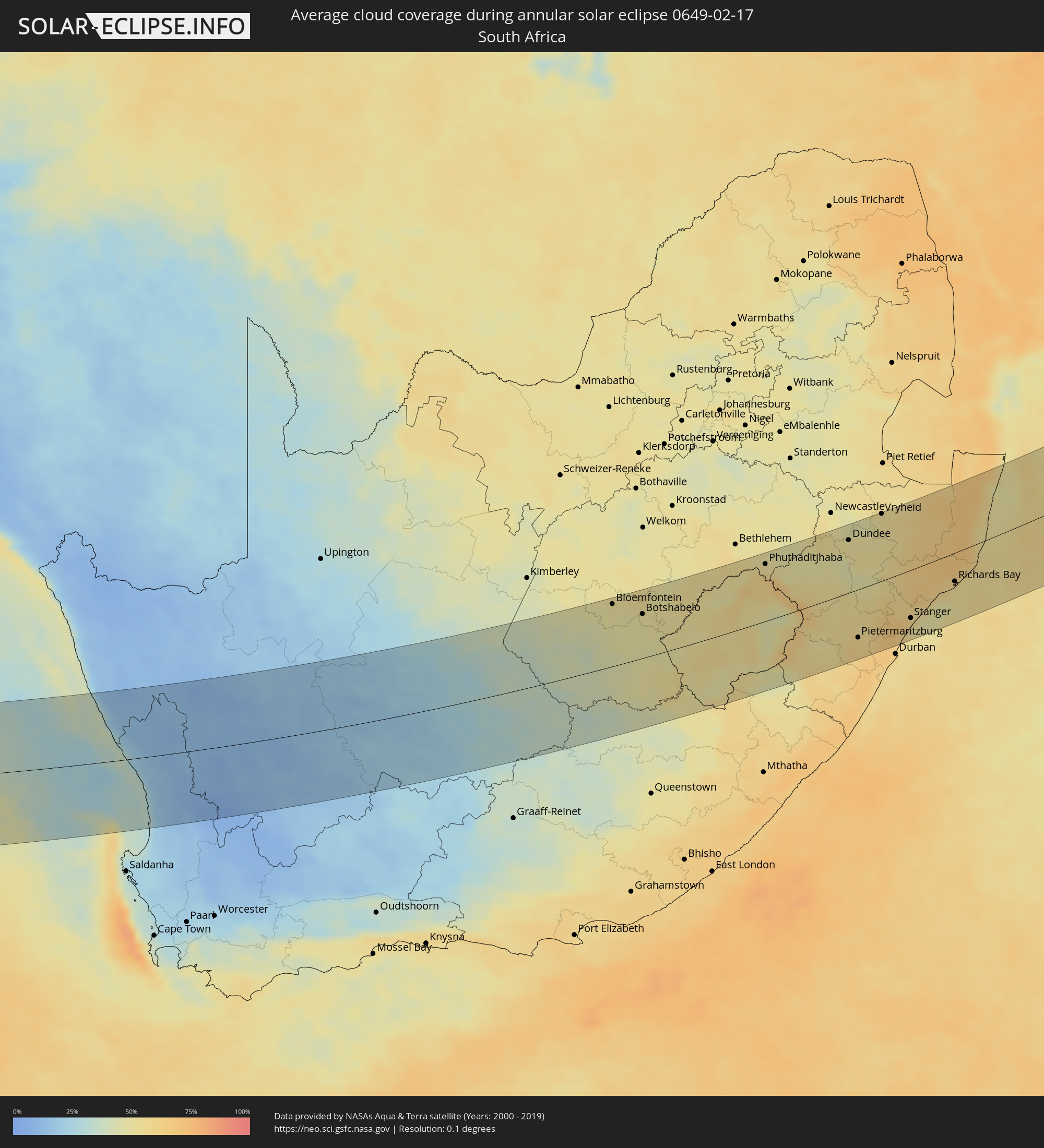 South Africa
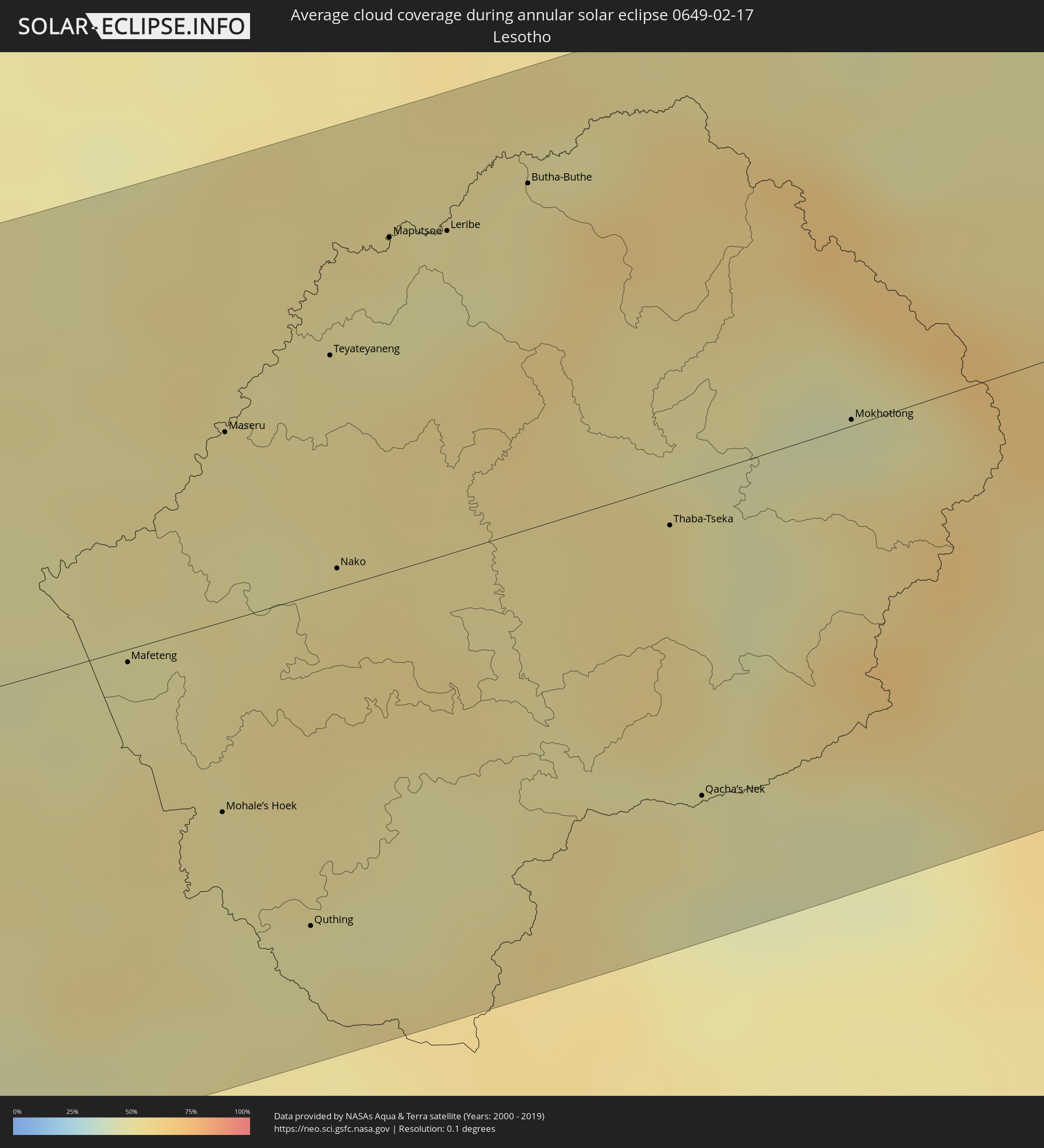 Lesotho
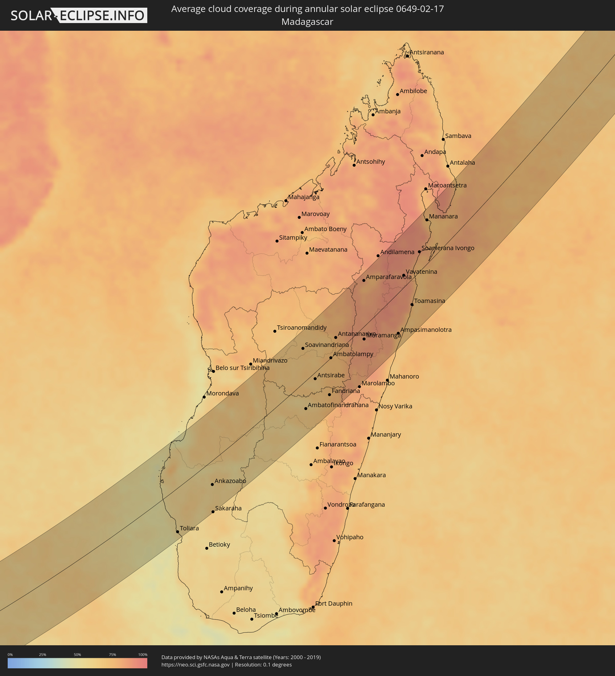 Madagascar
 Mauritius
 India
India
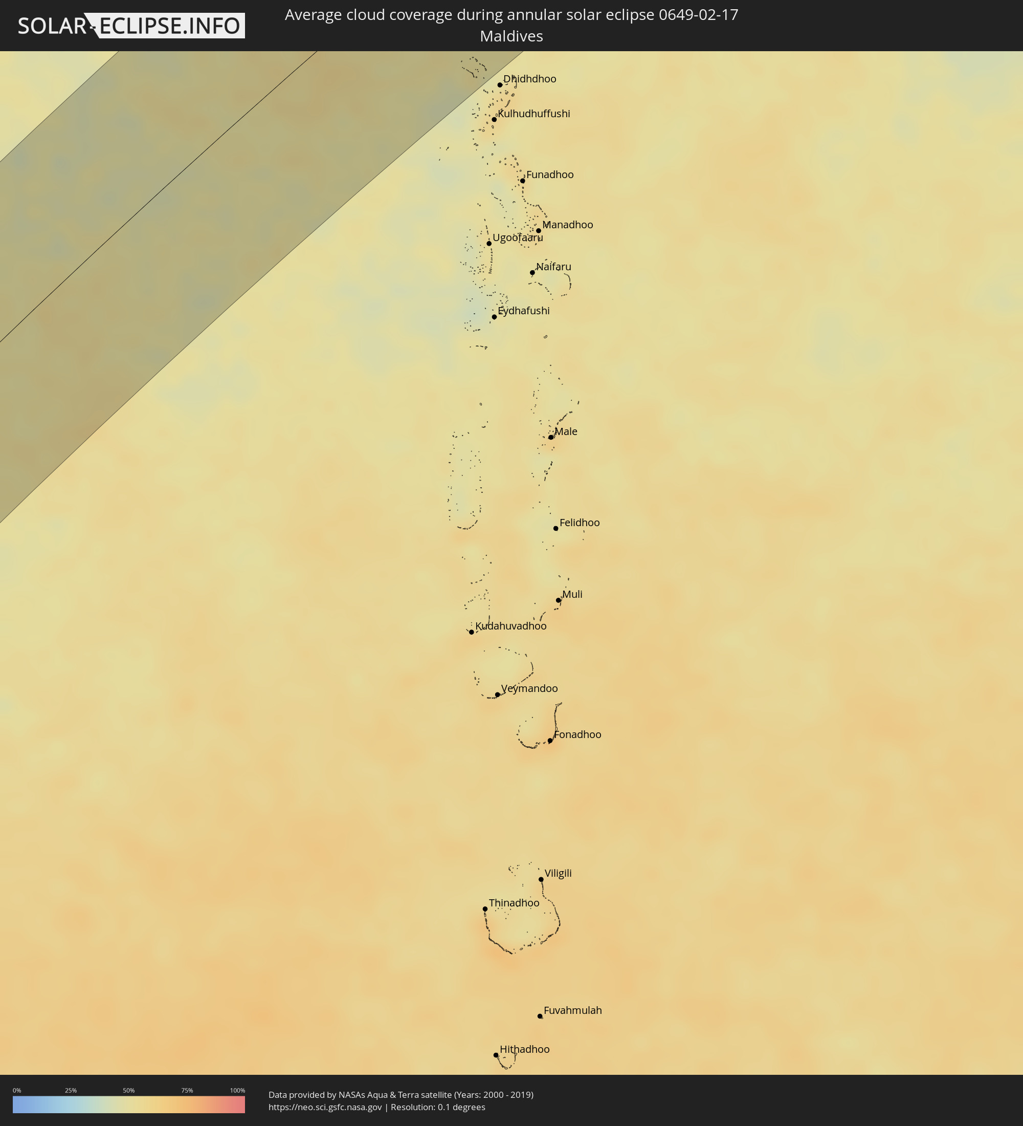 Maldives
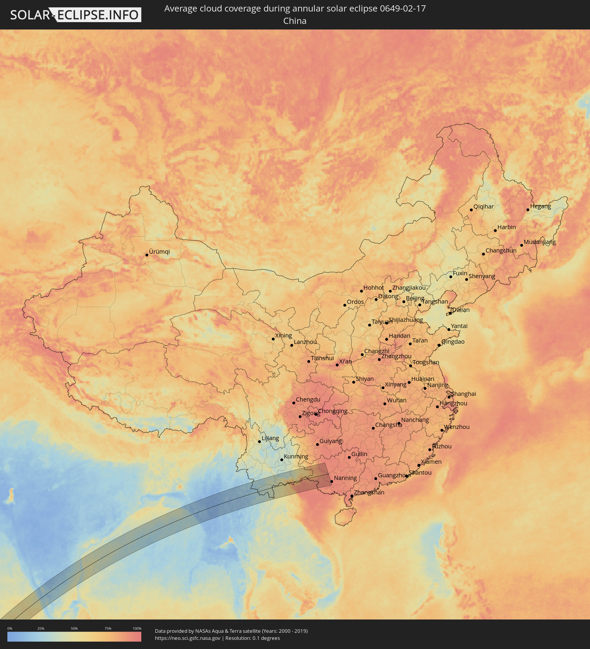 China
China
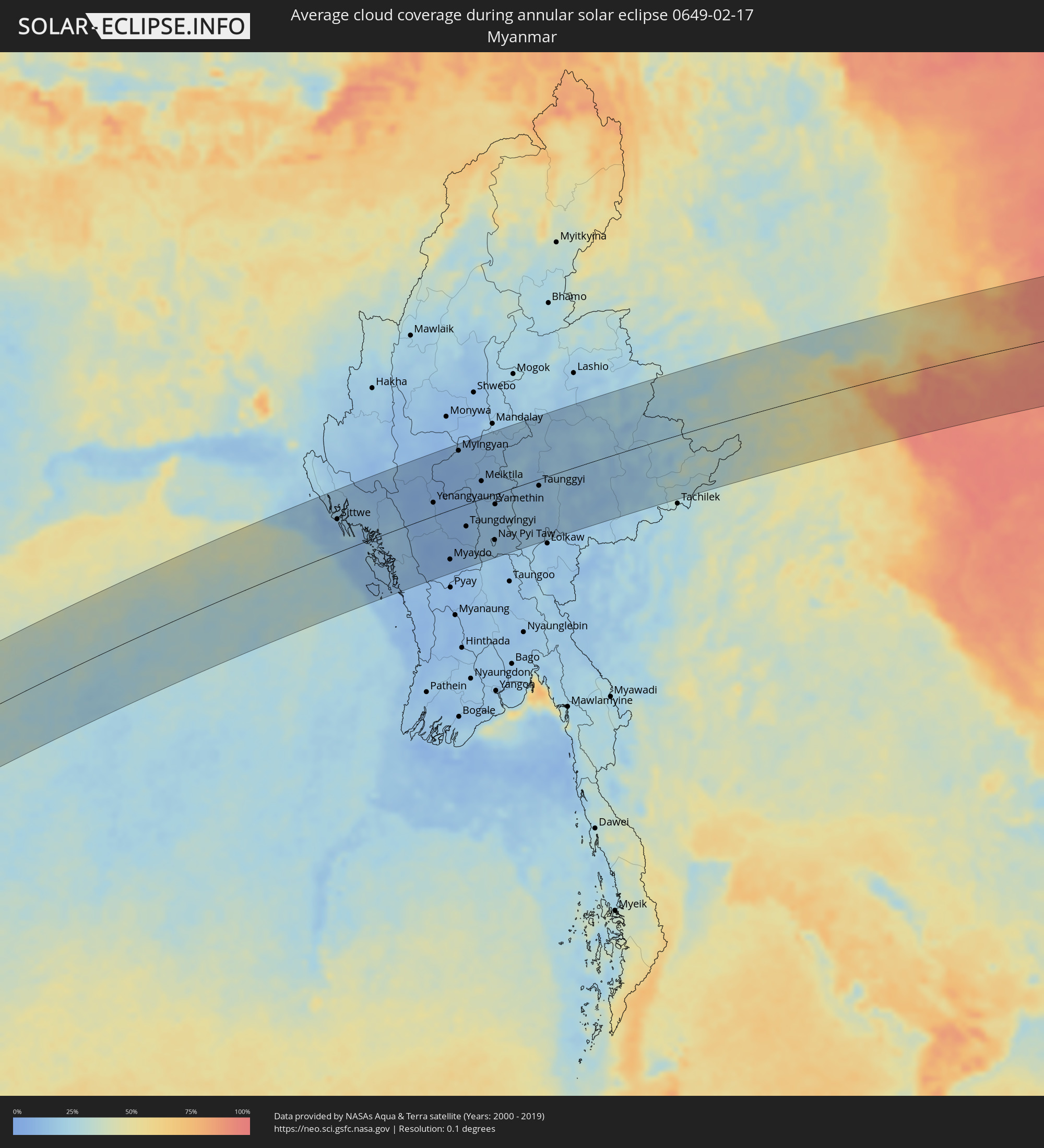 Myanmar
 Laos
Laos
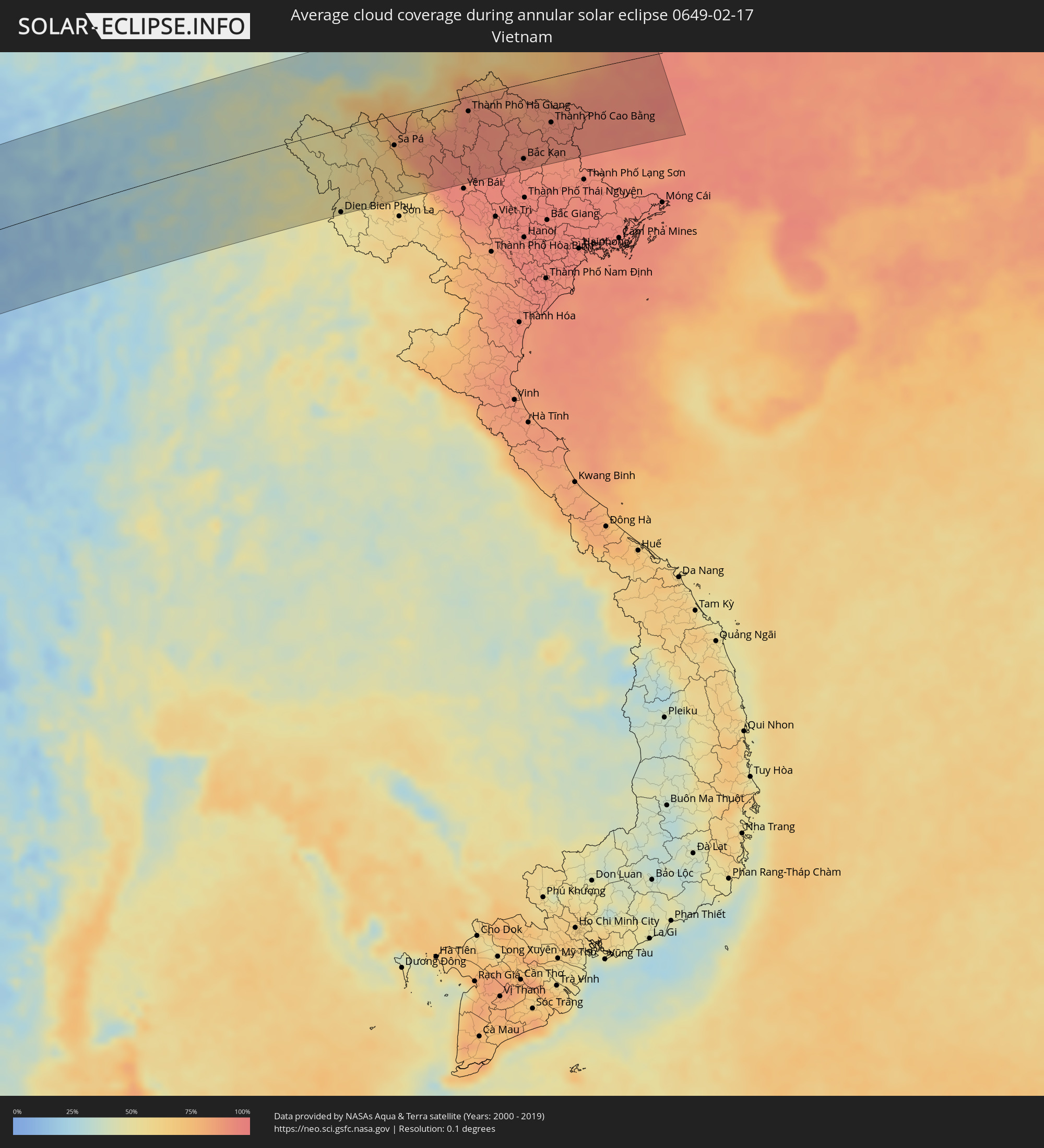 Vietnam
Cities inside the path of the eclipse
The following table shows all locations with a population of more than 5,000 inside the eclipse path. Cities which have more than 100,000 inhabitants are marked bold. A click at the locations opens a detailed map.
| City | Type | Eclipse duration | Local time of max. eclipse | Distance to central line | Ø Cloud coverage |
|
Vredendal, Western Cape
|
annular | - | 08:40:59 UTC+01:30 | 36 km | 15% |
|
De Aar, Northern Cape
|
annular | - | 08:48:46 UTC+01:30 | 15 km | 30% |
|
Bloemfontein, Orange Free State
|
annular | - | 08:53:01 UTC+01:30 | 99 km | 52% |
|
Aliwal North, Eastern Cape
|
annular | - | 08:52:54 UTC+01:30 | 83 km | 42% |
|
Botshabelo, Orange Free State
|
annular | - | 08:53:46 UTC+01:30 | 70 km | 48% |
|
Thaba Nchu, Orange Free State
|
annular | - | 08:53:59 UTC+01:30 | 73 km | 51% |
|
Mafeteng, Mafeteng
|
annular | - | 08:54:16 UTC+01:30 | 3 km | 48% |
|
Ladybrand, Orange Free State
|
annular | - | 08:55:02 UTC+01:30 | 58 km | 53% |
|
Mohale’s Hoek, Mohaleʼs Hoek
|
annular | - | 08:54:27 UTC+01:30 | 45 km | 50% |
|
Maseru, Maseru
|
annular | - | 08:55:00 UTC+01:30 | 44 km | 51% |
|
Quthing, Quthing
|
annular | - | 08:54:40 UTC+01:30 | 77 km | 49% |
|
Teyateyaneng, Berea
|
annular | - | 08:55:34 UTC+01:30 | 55 km | 52% |
|
Nako, Maseru
|
annular | - | 08:55:16 UTC+01:30 | 4 km | 54% |
|
Maputsoe, Leribe
|
annular | - | 08:56:00 UTC+01:30 | 79 km | 49% |
|
Leribe, Leribe
|
annular | - | 08:56:15 UTC+01:30 | 76 km | 48% |
|
Butha-Buthe, Butha-Buthe
|
annular | - | 08:56:41 UTC+01:30 | 81 km | 51% |
|
Thaba-Tseka, Thaba-Tseka
|
annular | - | 08:56:46 UTC+01:30 | 10 km | 55% |
|
Qacha’s Nek, Qachaʼs Nek
|
annular | - | 08:56:29 UTC+01:30 | 75 km | 50% |
|
Phuthaditjhaba, Orange Free State
|
annular | - | 08:57:52 UTC+01:30 | 90 km | 53% |
|
Mokhotlong, Mokhotlong
|
annular | - | 08:57:43 UTC+01:30 | 1 km | 46% |
|
Harrismith, Orange Free State
|
annular | - | 08:58:37 UTC+01:30 | 107 km | 47% |
|
Ekuvukeni, KwaZulu-Natal
|
annular | - | 09:00:18 UTC+01:30 | 54 km | 46% |
|
Mpophomeni, KwaZulu-Natal
|
annular | - | 08:59:28 UTC+01:30 | 63 km | 59% |
|
Howick, KwaZulu-Natal
|
annular | - | 08:59:37 UTC+01:30 | 55 km | 55% |
|
Dundee, KwaZulu-Natal
|
annular | - | 09:00:42 UTC+01:30 | 82 km | 52% |
|
Richmond, KwaZulu-Natal
|
annular | - | 08:59:23 UTC+01:30 | 98 km | 62% |
|
Pietermaritzburg, KwaZulu-Natal
|
annular | - | 08:59:47 UTC+01:30 | 75 km | 59% |
|
Mpumalanga, KwaZulu-Natal
|
annular | - | 09:00:03 UTC+01:30 | 103 km | 65% |
|
Mondlo, KwaZulu-Natal
|
annular | - | 09:01:45 UTC+01:30 | 85 km | 50% |
|
Vryheid, KwaZulu-Natal
|
annular | - | 09:02:05 UTC+01:30 | 105 km | 53% |
|
Ballitoville, KwaZulu-Natal
|
annular | - | 09:01:18 UTC+01:30 | 94 km | 56% |
|
Stanger, KwaZulu-Natal
|
annular | - | 09:01:37 UTC+01:30 | 74 km | 58% |
|
Ulundi, KwaZulu-Natal
|
annular | - | 09:02:43 UTC+01:30 | 24 km | 61% |
|
Eshowe, KwaZulu-Natal
|
annular | - | 09:02:20 UTC+01:30 | 35 km | 63% |
|
Empangeni, KwaZulu-Natal
|
annular | - | 09:03:13 UTC+01:30 | 37 km | 59% |
|
eSikhawini, KwaZulu-Natal
|
annular | - | 09:03:08 UTC+01:30 | 48 km | 53% |
|
Richards Bay, KwaZulu-Natal
|
annular | - | 09:03:28 UTC+01:30 | 44 km | 55% |
|
Toliara, Atsimo-Andrefana
|
annular | - | 10:32:17 UTC+02:27 | 88 km | 53% |
|
Ankazoabo, Atsimo-Andrefana
|
annular | - | 10:36:12 UTC+02:27 | 48 km | 60% |
|
Soavinandriana, Itasy
|
annular | - | 10:47:42 UTC+02:27 | 66 km | 68% |
|
Miandrarivo, Vakinankaratra
|
annular | - | 10:47:09 UTC+02:27 | 43 km | 67% |
|
Ambatofinandrahana, Amoron'i Mania
|
annular | - | 10:44:50 UTC+02:27 | 54 km | 66% |
|
Betafo, Vakinankaratra
|
annular | - | 10:46:30 UTC+02:27 | 3 km | 62% |
|
Faratsiho, Vakinankaratra
|
annular | - | 10:47:40 UTC+02:27 | 31 km | 65% |
|
Antsirabe, Vakinankaratra
|
annular | - | 10:46:50 UTC+02:27 | 13 km | 66% |
|
Arivonimamo, Itasy
|
annular | - | 10:49:03 UTC+02:27 | 46 km | 68% |
|
Ambositra, Amoron'i Mania
|
annular | - | 10:45:52 UTC+02:27 | 83 km | 72% |
|
Antanifotsy, Vakinankaratra
|
annular | - | 10:47:57 UTC+02:27 | 15 km | 73% |
|
Fandriana, Amoron'i Mania
|
annular | - | 10:46:49 UTC+02:27 | 68 km | 74% |
|
Ambatolampy, Vakinankaratra
|
annular | - | 10:48:45 UTC+02:27 | 1 km | 72% |
|
Antananarivo, Analamanga
|
annular | - | 10:50:05 UTC+02:27 | 29 km | 74% |
|
Manjakandriana, Analamanga
|
annular | - | 10:50:40 UTC+02:27 | 10 km | 78% |
|
Amparafaravola, Alaotra Mangoro
|
annular | - | 10:54:40 UTC+02:27 | 85 km | 79% |
|
Moramanga, Alaotra Mangoro
|
annular | - | 10:51:33 UTC+02:27 | 24 km | 83% |
|
Ambatondrazaka, Alaotra Mangoro
|
annular | - | 10:54:32 UTC+02:27 | 51 km | 83% |
|
Vohibinany, Atsinanana
|
annular | - | 10:57:03 UTC+02:27 | 43 km | 87% |
|
Ampasimanolotra, Atsinanana
|
annular | - | 10:53:43 UTC+02:27 | 75 km | 72% |
|
Vavatenina, Analanjirofo
|
annular | - | 10:57:09 UTC+02:27 | 21 km | 85% |
|
Toamasina, Atsinanana
|
annular | - | 10:56:00 UTC+02:27 | 47 km | 75% |
|
Fenoarivo Atsinanana, Analanjirofo
|
annular | - | 10:57:49 UTC+02:27 | 12 km | 78% |
|
Soanierana Ivongo, Analanjirofo
|
annular | - | 10:59:19 UTC+02:27 | 35 km | 78% |
|
Mananara, Analanjirofo
|
annular | - | 11:01:31 UTC+02:27 | 79 km | 75% |
|
Kozhikode, Kerala
|
annular | - | 15:40:46 UTC+05:21 | 74 km | 23% |
|
Ponnāni, Kerala
|
annular | - | 15:40:13 UTC+05:21 | 21 km | 21% |
|
Trichūr, Kerala
|
annular | - | 15:40:10 UTC+05:21 | 20 km | 25% |
|
Cochin, Kerala
|
annular | - | 15:39:21 UTC+05:21 | 75 km | 32% |
|
Mysore, Karnataka
|
annular | - | 15:43:07 UTC+05:21 | 114 km | 12% |
|
Palakkad, Kerala
|
annular | - | 15:41:00 UTC+05:21 | 25 km | 16% |
|
Coimbatore, Tamil Nadu
|
annular | - | 15:41:39 UTC+05:21 | 24 km | 24% |
|
Tiruppur, Tamil Nadu
|
annular | - | 15:42:12 UTC+05:21 | 39 km | 25% |
|
Bengaluru, Karnataka
|
annular | - | 15:44:57 UTC+05:21 | 116 km | 15% |
|
Erode, Tamil Nadu
|
annular | - | 15:42:53 UTC+05:21 | 42 km | 25% |
|
Hosūr, Tamil Nadu
|
annular | - | 15:44:52 UTC+05:21 | 80 km | 19% |
|
Kolār, Karnataka
|
annular | - | 15:45:40 UTC+05:21 | 98 km | 17% |
|
Salem, Tamil Nadu
|
annular | - | 15:43:44 UTC+05:21 | 40 km | 26% |
|
Robertsonpet, Karnataka
|
annular | - | 15:45:34 UTC+05:21 | 73 km | 19% |
|
Madanapalle, Andhra Pradesh
|
annular | - | 15:46:32 UTC+05:21 | 114 km | 19% |
|
Ambur, Tamil Nadu
|
annular | - | 15:45:46 UTC+05:21 | 31 km | 25% |
|
Tiruvannāmalai, Tamil Nadu
|
annular | - | 15:45:23 UTC+05:21 | 43 km | 35% |
|
Vellore, Tamil Nadu
|
annular | - | 15:46:19 UTC+05:21 | 18 km | 31% |
|
Tirupati, Andhra Pradesh
|
annular | - | 15:47:28 UTC+05:21 | 68 km | 27% |
|
Kānchipuram, Tamil Nadu
|
annular | - | 15:46:44 UTC+05:21 | 23 km | 40% |
|
Puducherry, Pondicherry
|
annular | - | 15:45:42 UTC+05:21 | 115 km | 33% |
|
Nellore, Andhra Pradesh
|
annular | - | 15:48:57 UTC+05:21 | 112 km | 35% |
|
Āvadi, Tamil Nadu
|
annular | - | 15:47:27 UTC+05:21 | 21 km | 41% |
|
Pallāvaram, Tamil Nadu
|
annular | - | 15:47:18 UTC+05:21 | 37 km | 34% |
|
Chennai, Tamil Nadu
|
annular | - | 15:47:34 UTC+05:21 | 33 km | 34% |
|
Sittwe, Rakhine
|
annular | - | 17:05:30 UTC+06:24 | 66 km | 11% |
|
Chauk, Magway
|
annular | - | 17:06:36 UTC+06:24 | 74 km | 7% |
|
Yenangyaung, Magway
|
annular | - | 17:06:22 UTC+06:24 | 27 km | 8% |
|
Minbu, Magway
|
annular | - | 17:06:12 UTC+06:24 | 3 km | 10% |
|
Magway, Magway
|
annular | - | 17:06:12 UTC+06:24 | 8 km | 11% |
|
Pakokku, Magway
|
annular | - | 17:06:55 UTC+06:24 | 111 km | 9% |
|
Thayetmyo, Magway
|
annular | - | 17:05:47 UTC+06:24 | 104 km | 9% |
|
Myaydo, Magway
|
annular | - | 17:05:49 UTC+06:24 | 100 km | 8% |
|
Myingyan, Mandalay
|
annular | - | 17:07:04 UTC+06:24 | 113 km | 11% |
|
Taungdwingyi, Magway
|
annular | - | 17:06:19 UTC+06:24 | 45 km | 9% |
|
Meiktila, Mandalay
|
annular | - | 17:06:54 UTC+06:24 | 36 km | 10% |
|
Nay Pyi Taw, Nay Pyi Taw
|
annular | - | 17:06:20 UTC+06:24 | 93 km | 17% |
|
Kyaukse, Mandalay
|
annular | - | 17:07:21 UTC+06:24 | 103 km | 14% |
|
Yamethin, Mandalay
|
annular | - | 17:06:44 UTC+06:24 | 21 km | 13% |
|
Pyinmana, Nay Pyi Taw
|
annular | - | 17:06:21 UTC+06:24 | 96 km | 15% |
|
Taunggyi, Shan
|
annular | - | 17:07:10 UTC+06:24 | 13 km | 14% |
|
Jinghong, Yunnan
|
annular | - | 18:43:41 UTC+08:00 | 1 km | 36% |
|
Phôngsali, Phôngsali
|
annular | - | 17:25:48 UTC+06:42 | 71 km | 48% |
|
Dien Bien Phu, Tỉnh Ðiện Biên
|
annular | - | 17:50:22 UTC+07:06 | 128 km | 52% |
|
Gejiu, Yunnan
|
annular | - | 18:44:28 UTC+08:00 | 81 km | 33% |
|
Kaiyuan, Yunnan
|
annular | - | 18:44:35 UTC+08:00 | 114 km | 36% |
|
Lai Châu, Lai Châu
|
annular | - | 17:50:48 UTC+07:06 | 30 km | 57% |
|
Sa Pá, Lào Cai
|
annular | - | 17:50:48 UTC+07:06 | 46 km | 68% |
|
Lào Cai, Lào Cai
|
annular | - | 17:50:52 UTC+07:06 | 34 km | 83% |
|
Wenshan City, Yunnan
|
annular | - | 18:44:31 UTC+08:00 | 54 km | 47% |
|
Kaihua, Yunnan
|
annular | - | 18:44:31 UTC+08:00 | 54 km | 47% |
|
Mabai, Yunnan
|
annular | - | 18:44:24 UTC+08:00 | 11 km | 68% |
|
Thành Phố Hà Giang, Hà Giang
|
annular | - | 17:51:02 UTC+07:06 | 22 km | 90% |
|
Bắc Kạn, Bắc Kạn
|
annular | - | 17:50:48 UTC+07:06 | 116 km | 91% |
|
Thành Phố Cao Bằng, Cao Bằng
|
annular | - | 17:50:59 UTC+07:06 | 70 km | 91% |
|
Baise City, Guangxi Zhuang Autonomous Region
|
annular | - | 18:44:42 UTC+08:00 | 56 km | 83% |