Total solar eclipse of 05/06/0859
| Day of week: | Tuesday |
| Maximum duration of eclipse: | 04m17s |
| Maximum width of eclipse path: | 144 km |
| Saros cycle: | 100 |
| Coverage: | 100% |
| Magnitude: | 1.042 |
| Gamma: | -0.2362 |
Wo kann man die Sonnenfinsternis vom 05/06/0859 sehen?
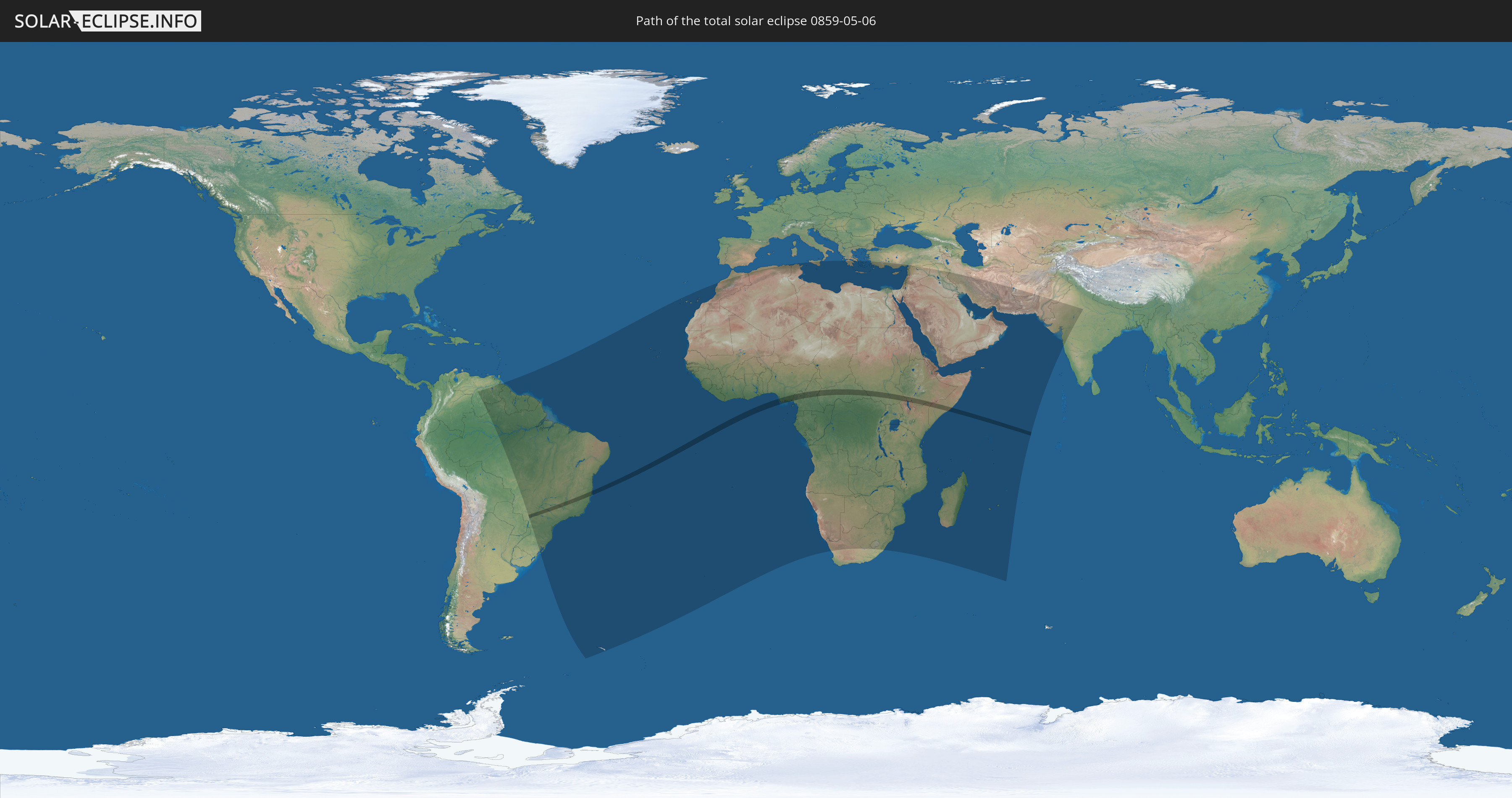
Die Sonnenfinsternis am 05/06/0859 kann man in 86 Ländern als partielle Sonnenfinsternis beobachten.
Der Finsternispfad verläuft durch 8 Länder. Nur in diesen Ländern ist sie als total Sonnenfinsternis zu sehen.
In den folgenden Ländern ist die Sonnenfinsternis total zu sehen
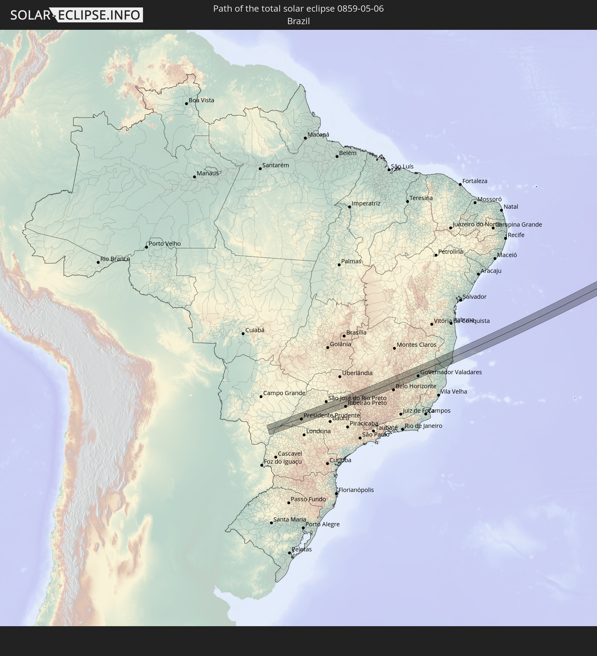 Brazil
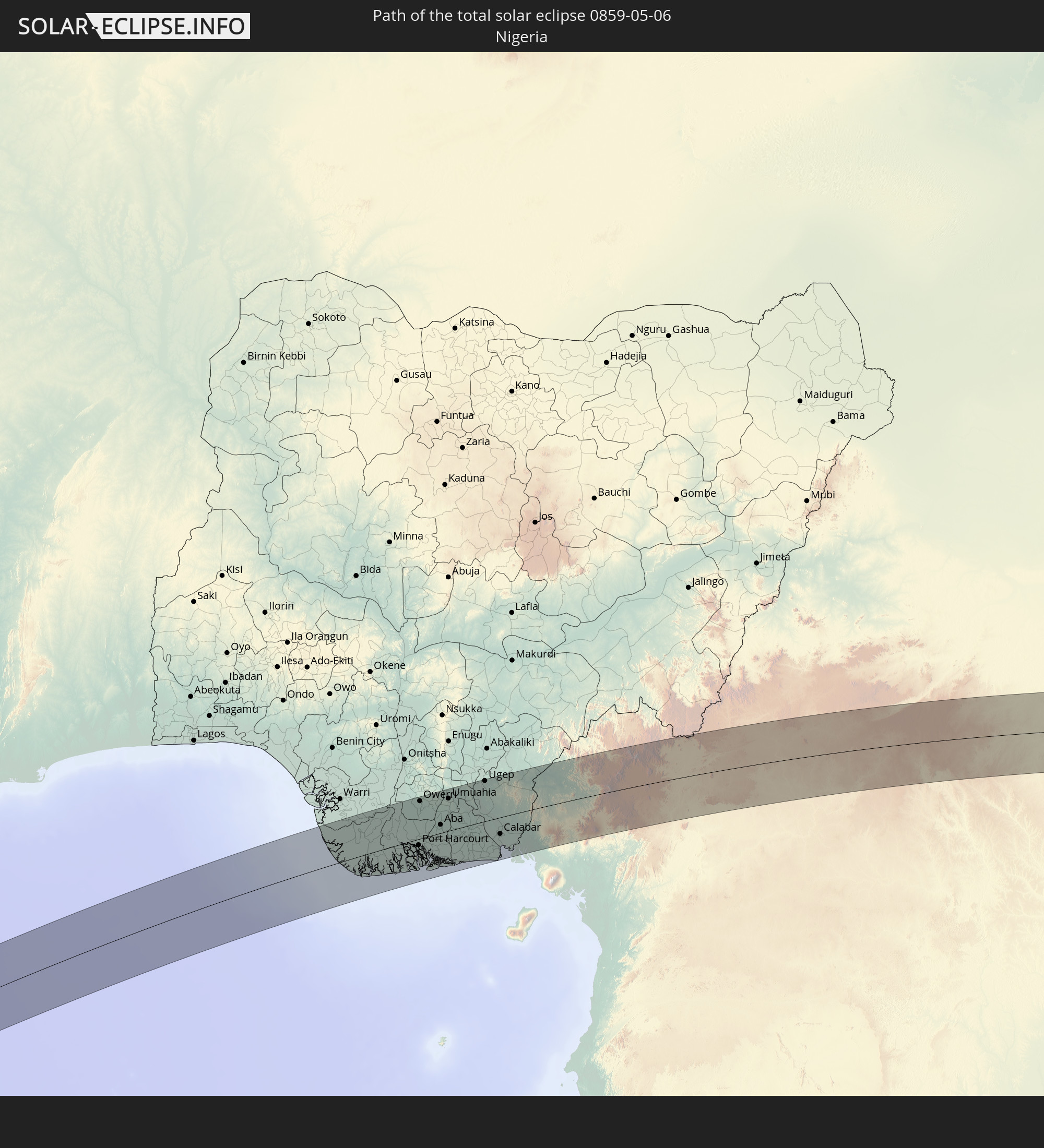 Nigeria
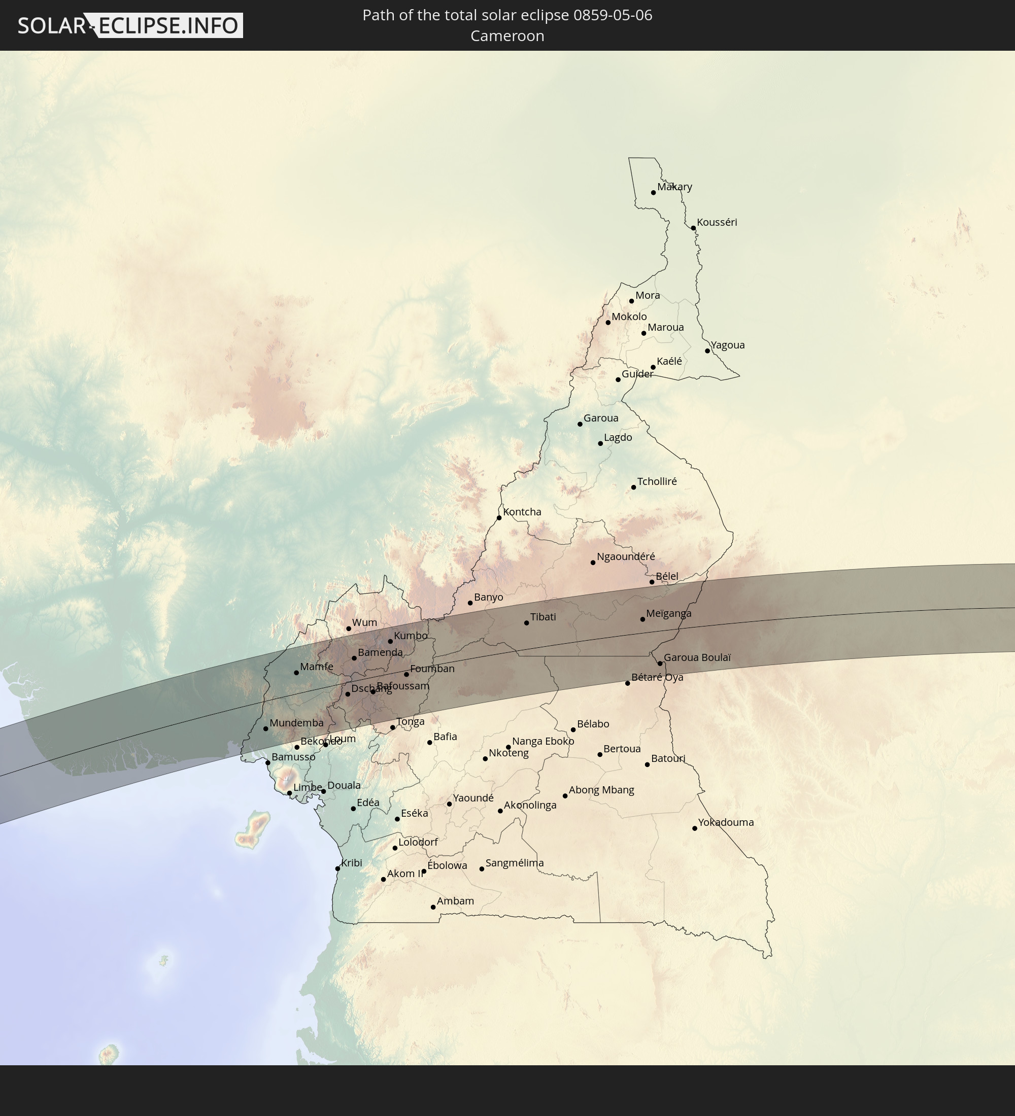 Cameroon
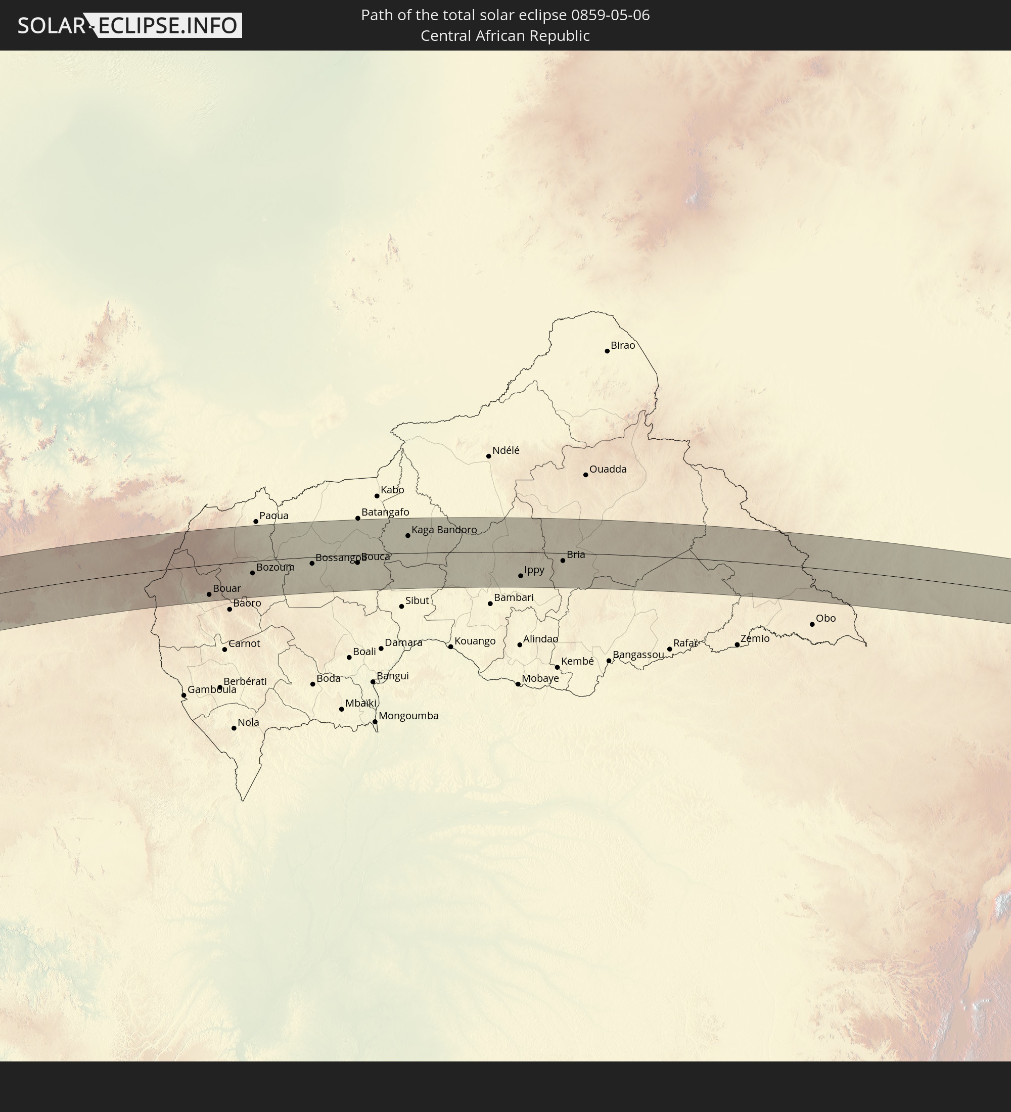 Central African Republic
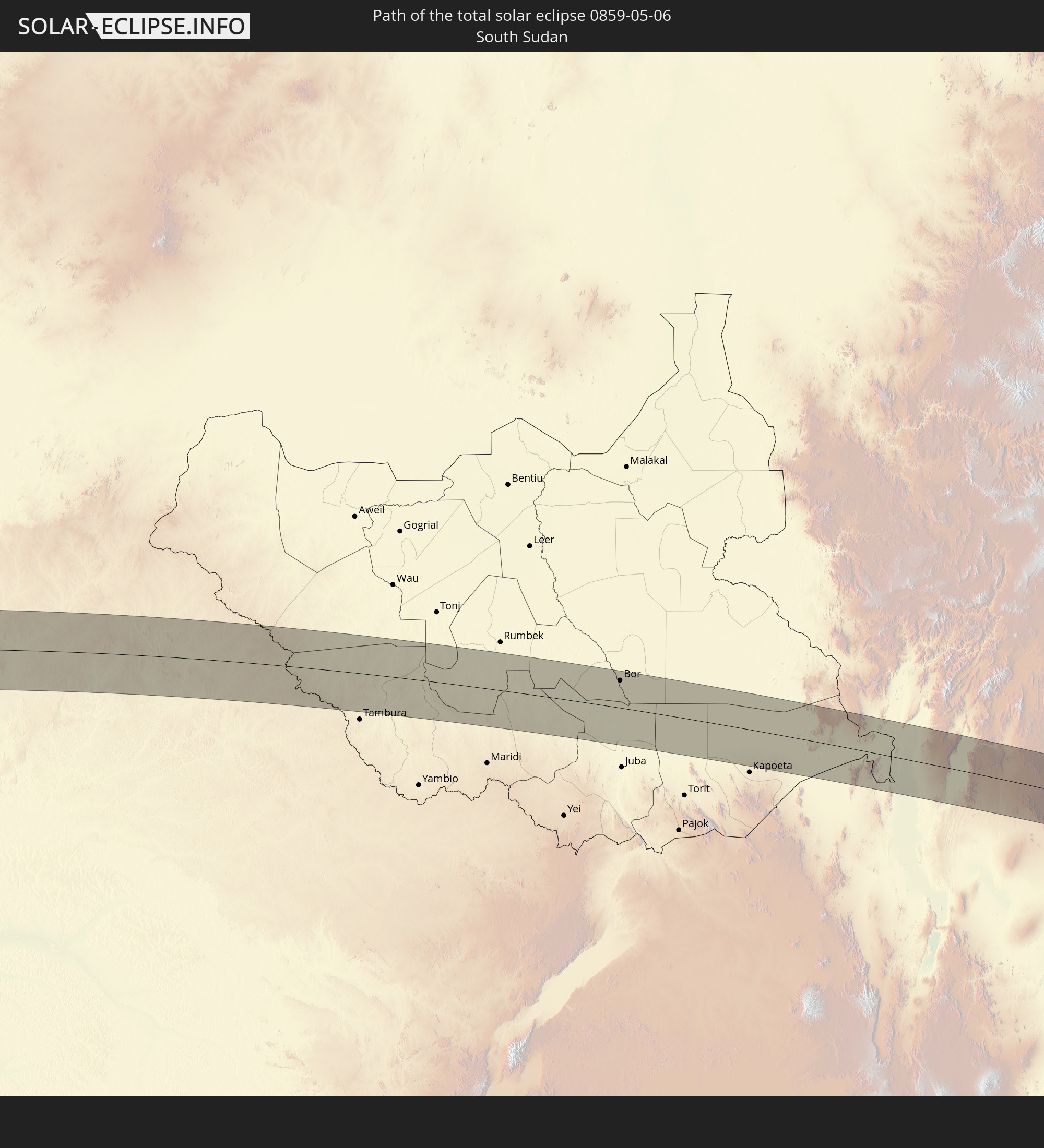 South Sudan
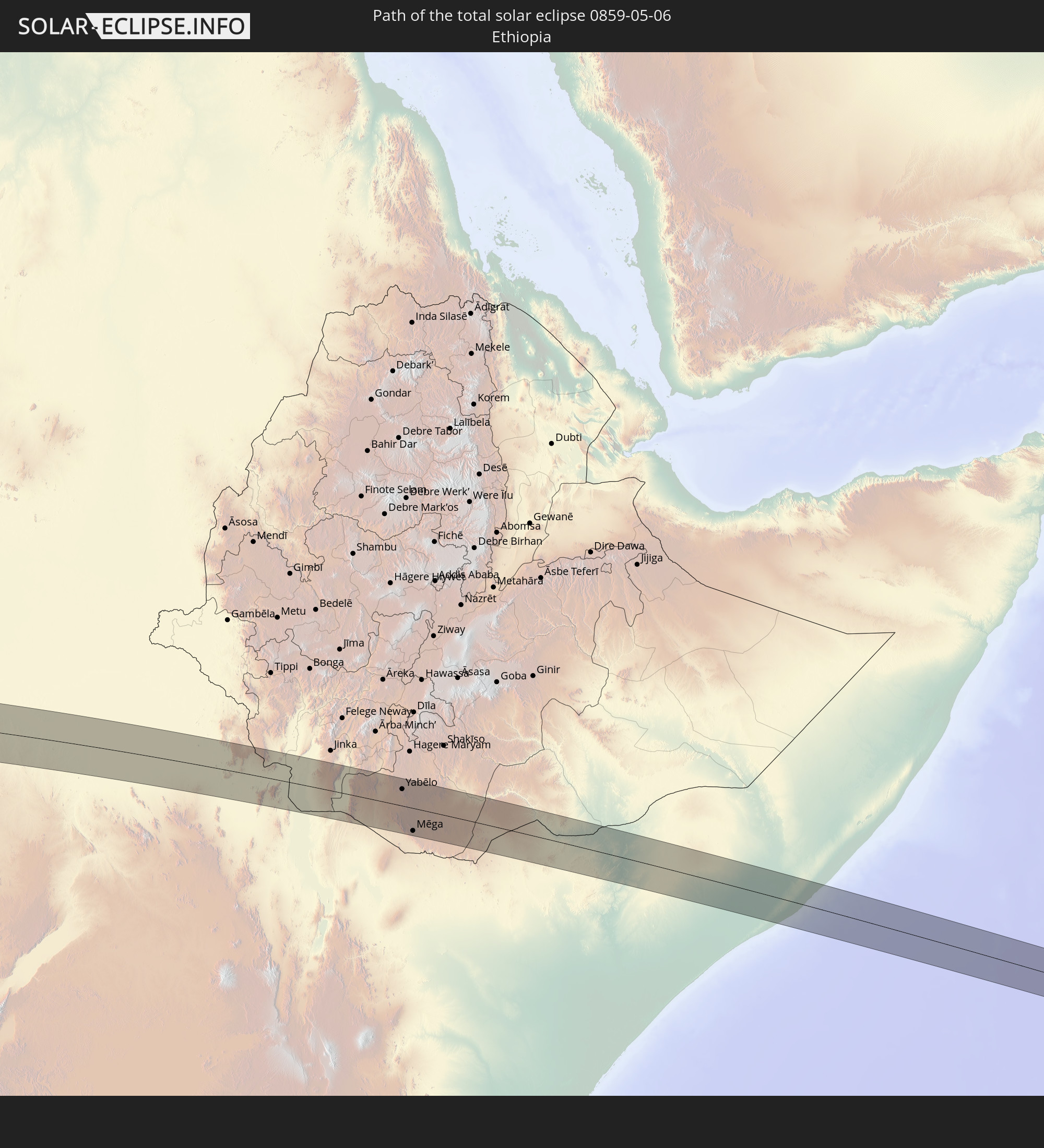 Ethiopia
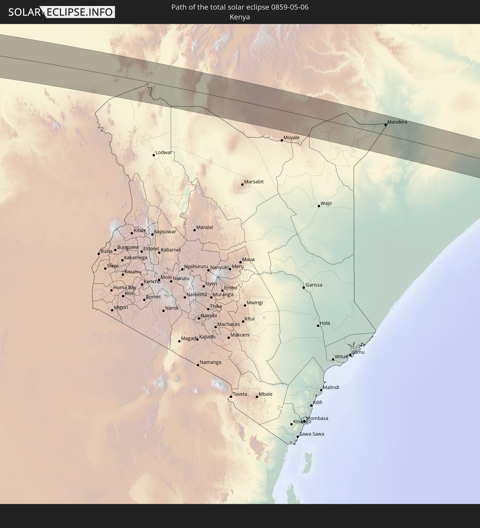 Kenya
Kenya
 Somalia
In den folgenden Ländern ist die Sonnenfinsternis partiell zu sehen
 Brazil
 Venezuela
 Guyana
 Suriname
 French Guiana
 South Georgia and the South Sandwich Islands
 Cabo Verde
 Spain
Spain
 Senegal
 Mauritania
 The Gambia
 Guinea-Bissau
 Guinea
 Saint Helena, Ascension and Tristan da Cunha
 Sierra Leone
 Morocco
 Mali
Mali
 Liberia
 Algeria
 Ivory Coast
 Burkina Faso
 Ghana
Ghana
 Togo
Togo
 Niger
Niger
 Benin
Benin
 Nigeria
 Equatorial Guinea
 São Tomé and Príncipe
 Italy
Italy
 Tunisia
 Cameroon
 Gabon
Gabon
 Libya
Libya
 Republic of the Congo
 Angola
 Namibia
 Democratic Republic of the Congo
 Chad
Chad
 Malta
Malta
 Central African Republic
 South Africa
 Greece
 Botswana
 Sudan
Sudan
 Zambia
 Egypt
Egypt
 Zimbabwe
 Turkey
 Lesotho
 Rwanda
 Burundi
 Tanzania
 Uganda
 Mozambique
 Swaziland
 Cyprus
 Malawi
 Ethiopia
 Kenya
Kenya
 State of Palestine
 Israel
 Saudi Arabia
 Jordan
 Lebanon
 Syria
Syria
 Eritrea
 Iraq
Iraq
 French Southern and Antarctic Lands
 Somalia
 Djibouti
 Yemen
Yemen
 Madagascar
 Comoros
 Iran
Iran
 Mayotte
 Seychelles
 Kuwait
 Bahrain
 Qatar
Qatar
 United Arab Emirates
 Oman
Oman
 Réunion
 Mauritius
 Afghanistan
 Pakistan
 India
India
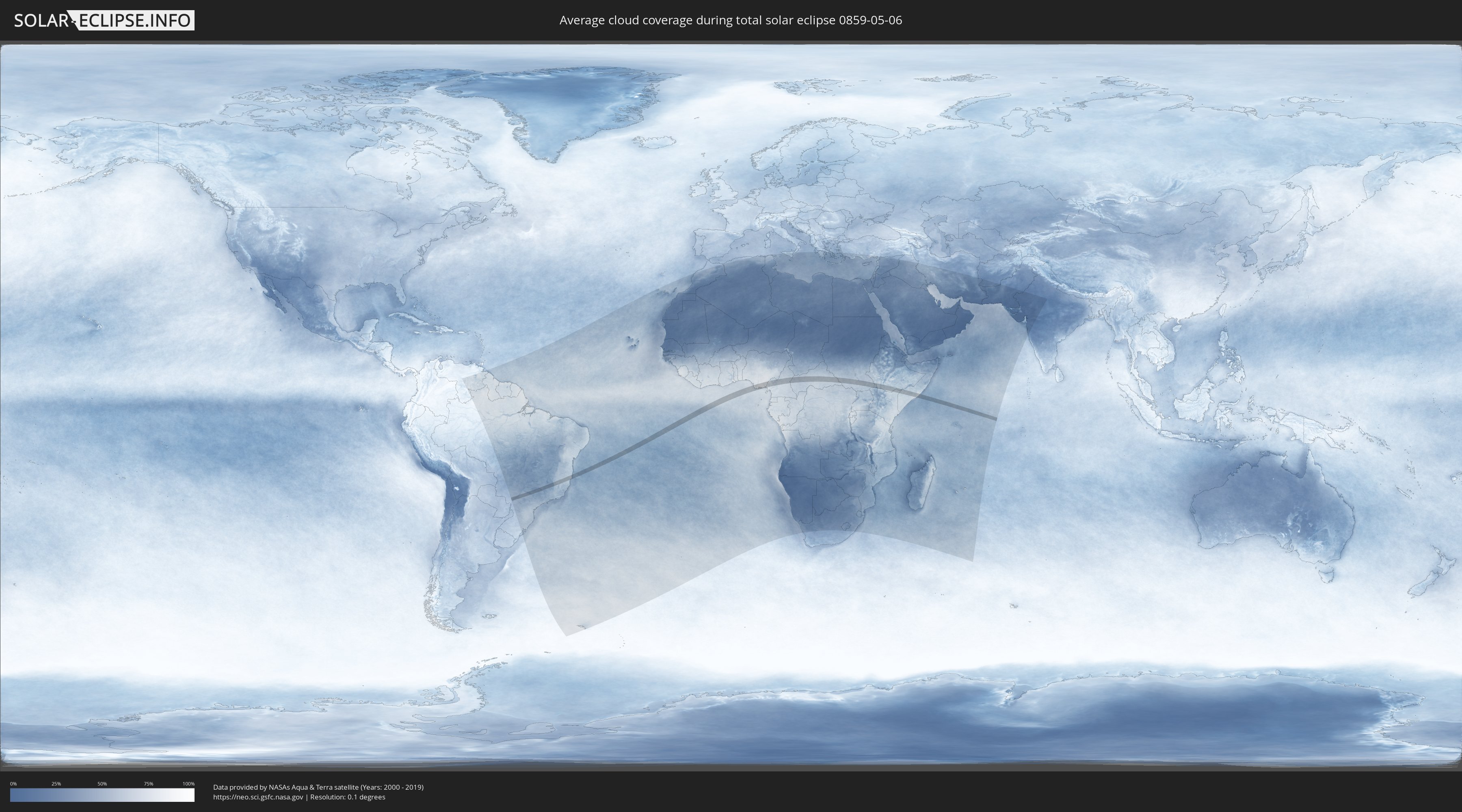
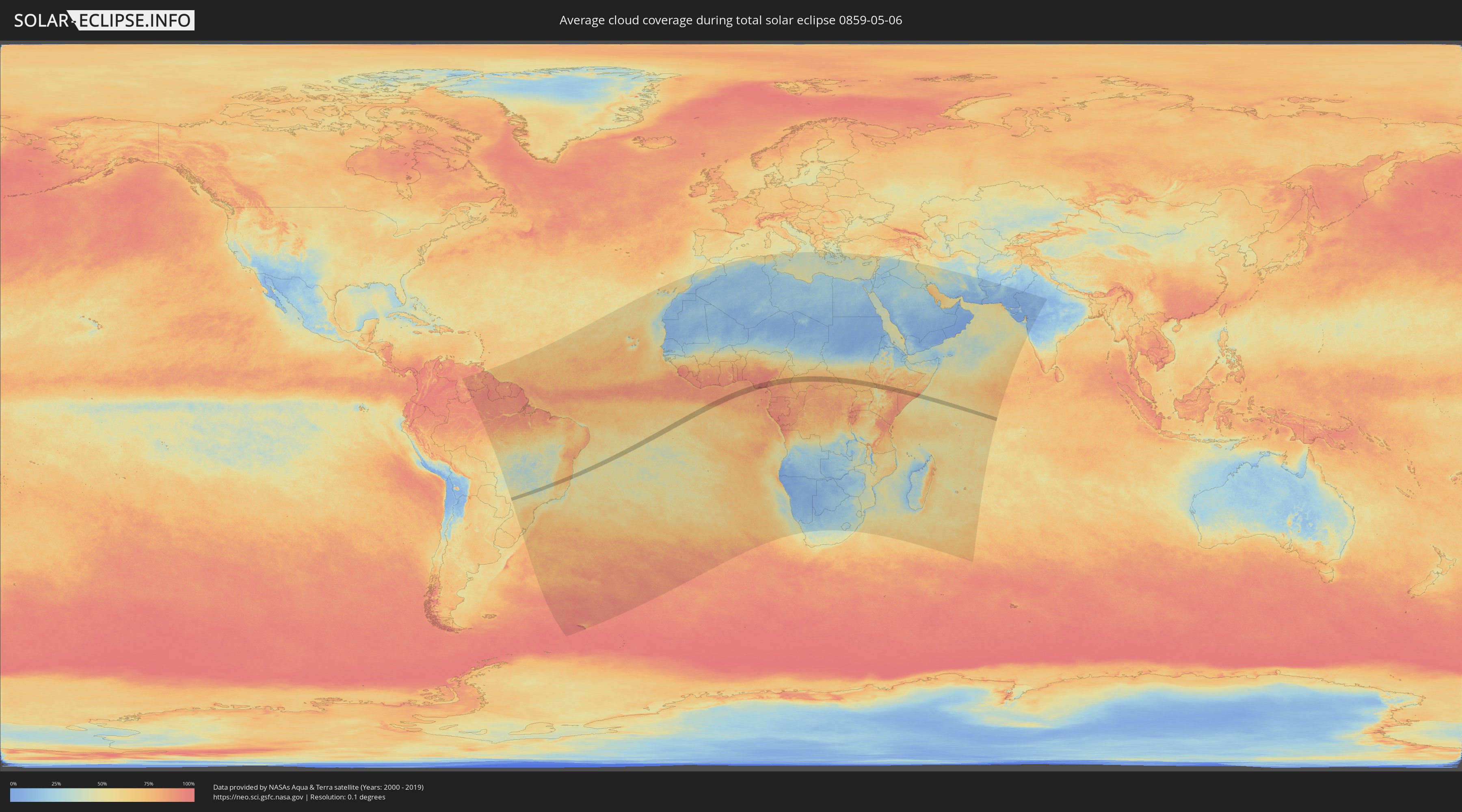
How will be the weather during the total solar eclipse on 05/06/0859?
Where is the best place to see the total solar eclipse of 05/06/0859?
The following maps show the average cloud coverage for the day of the total solar eclipse.
With the help of these maps, it is possible to find the place along the eclipse path, which has the best
chance of a cloudless sky.
Nevertheless, you should consider local circumstances and inform about the weather of your chosen
observation site.
The data is provided by NASAs satellites
AQUA and TERRA.
The cloud maps are averaged over a period of 19 years (2000 - 2019).
Detailed country maps
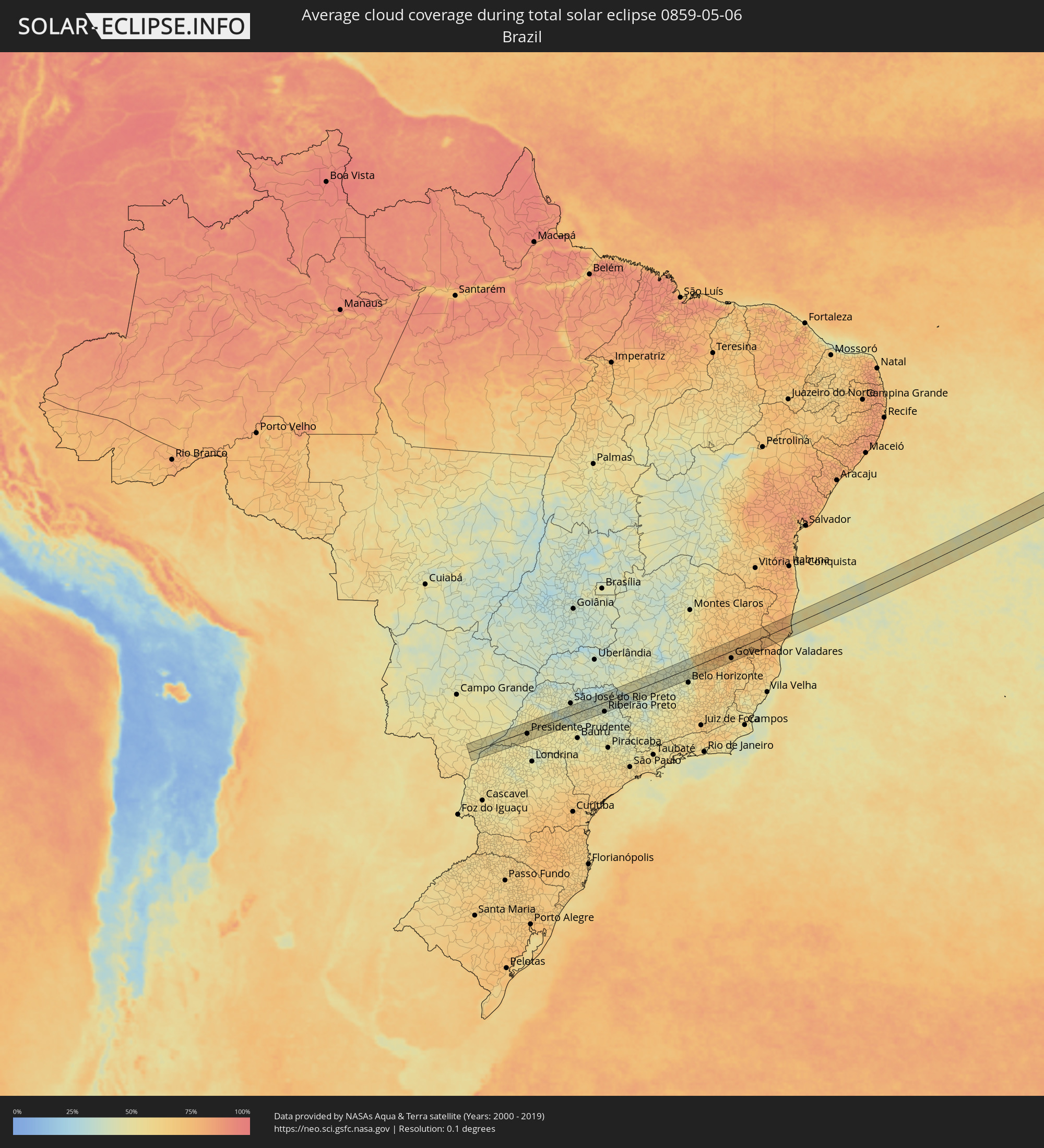 Brazil
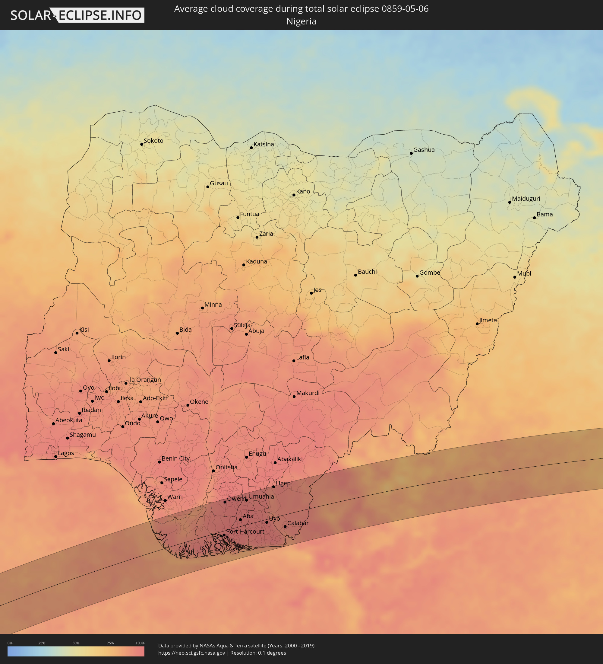 Nigeria
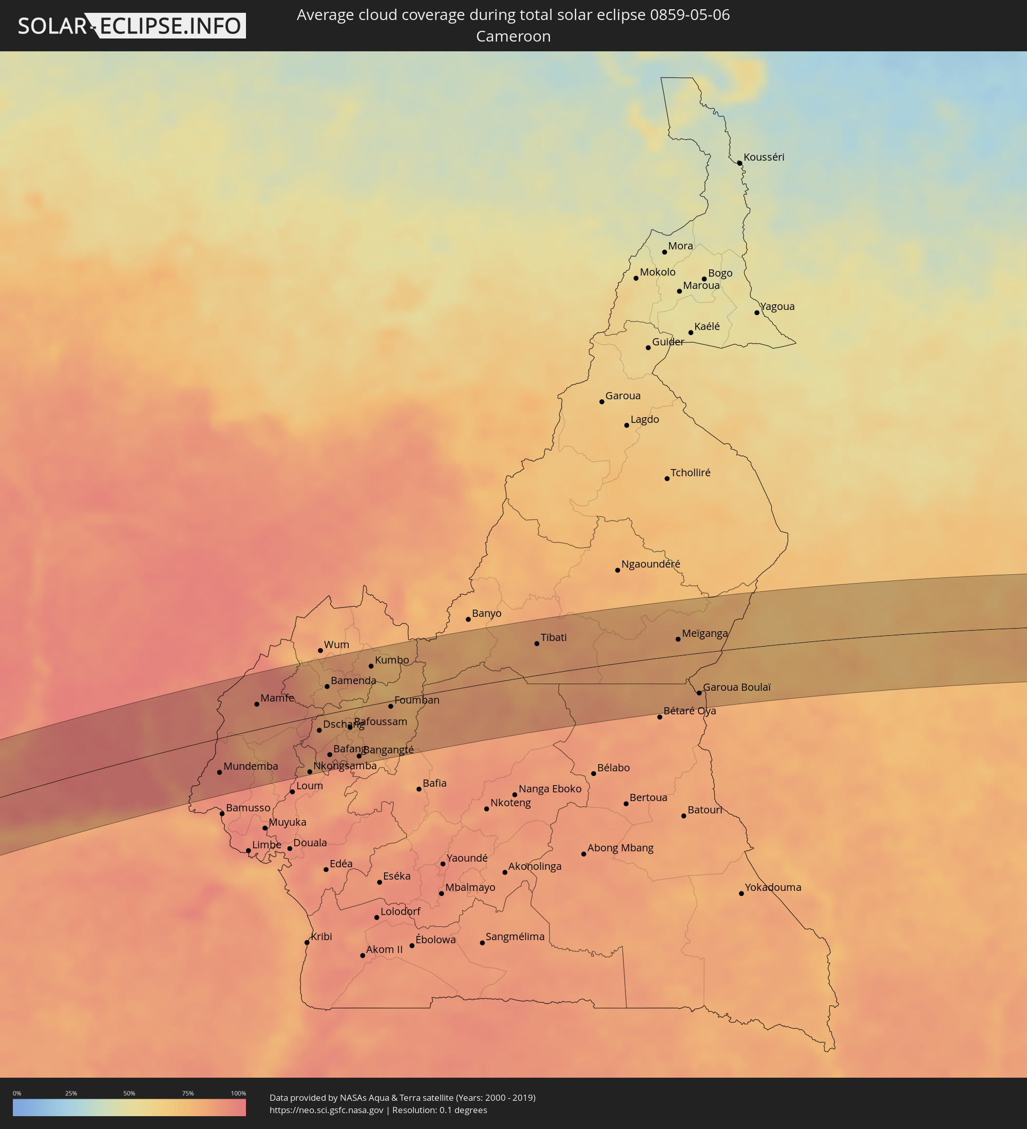 Cameroon
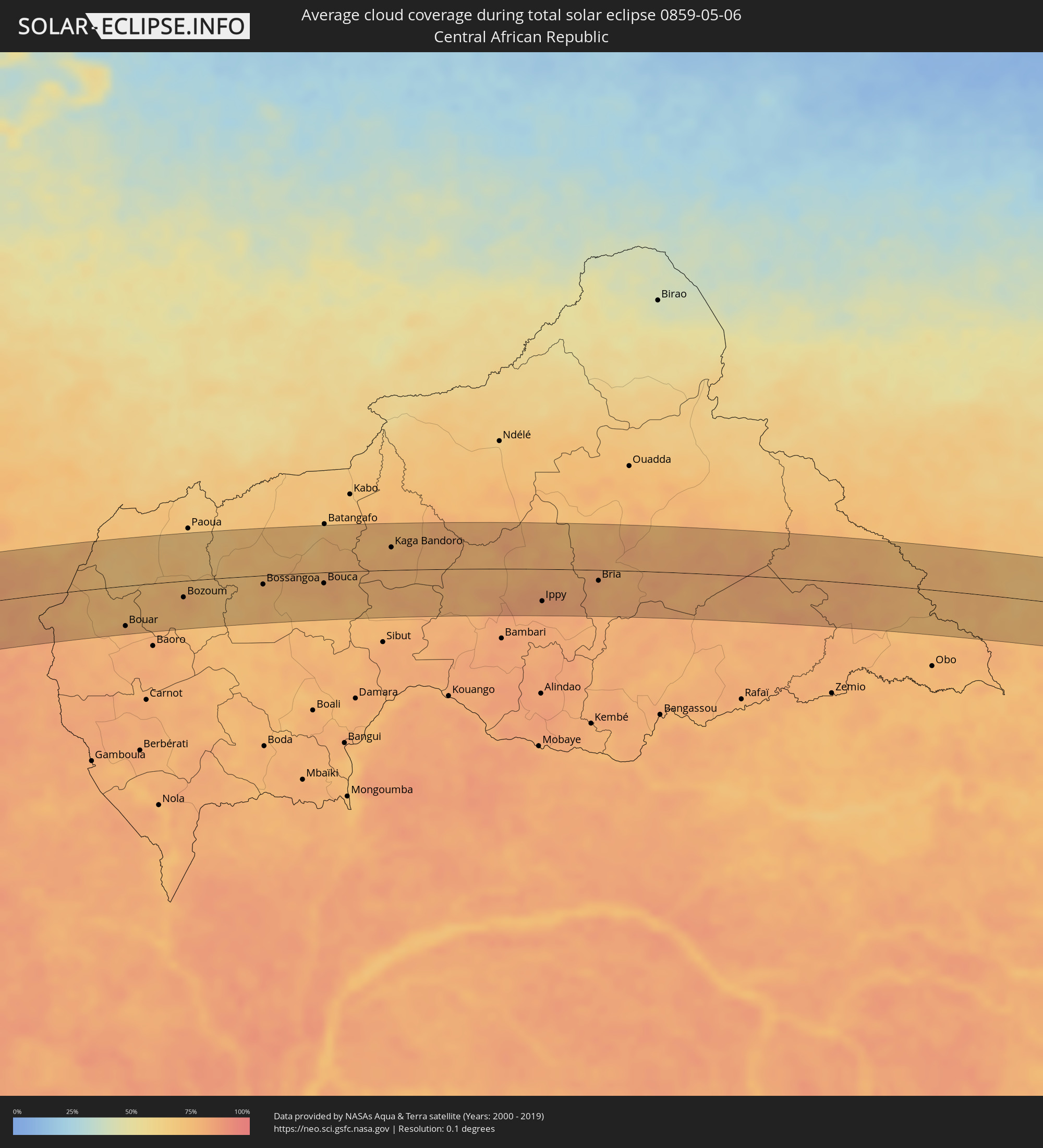 Central African Republic
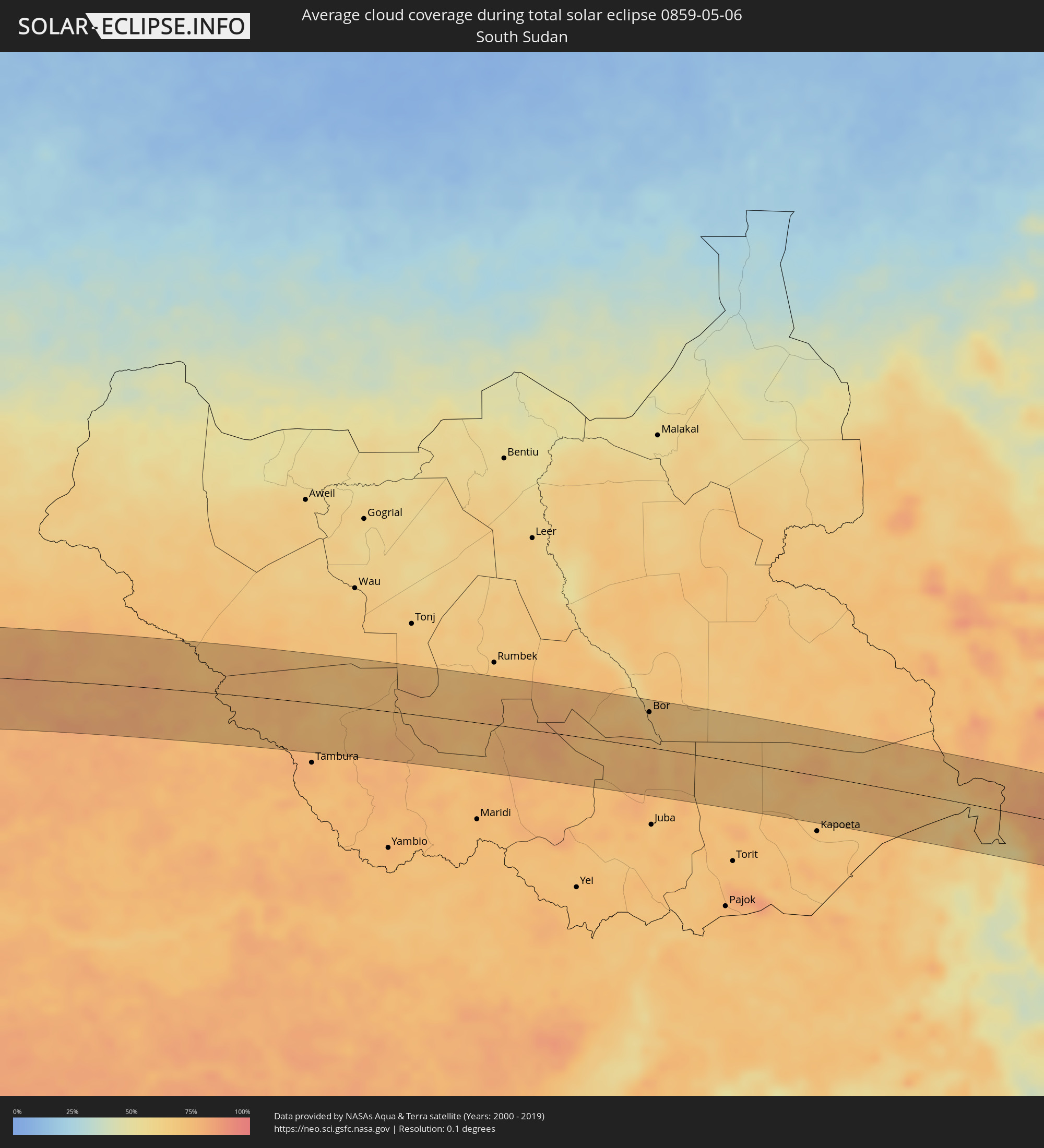 South Sudan
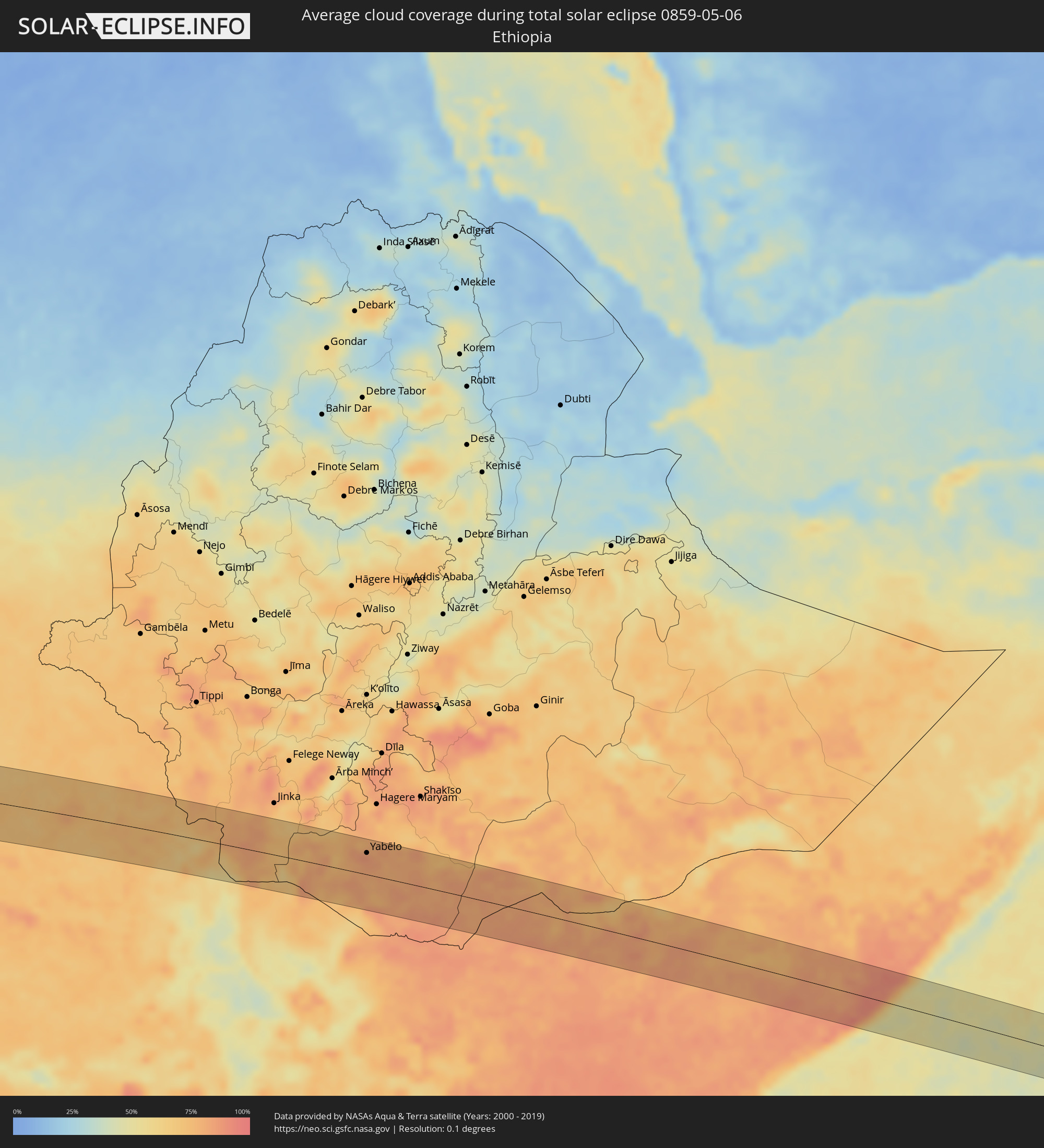 Ethiopia
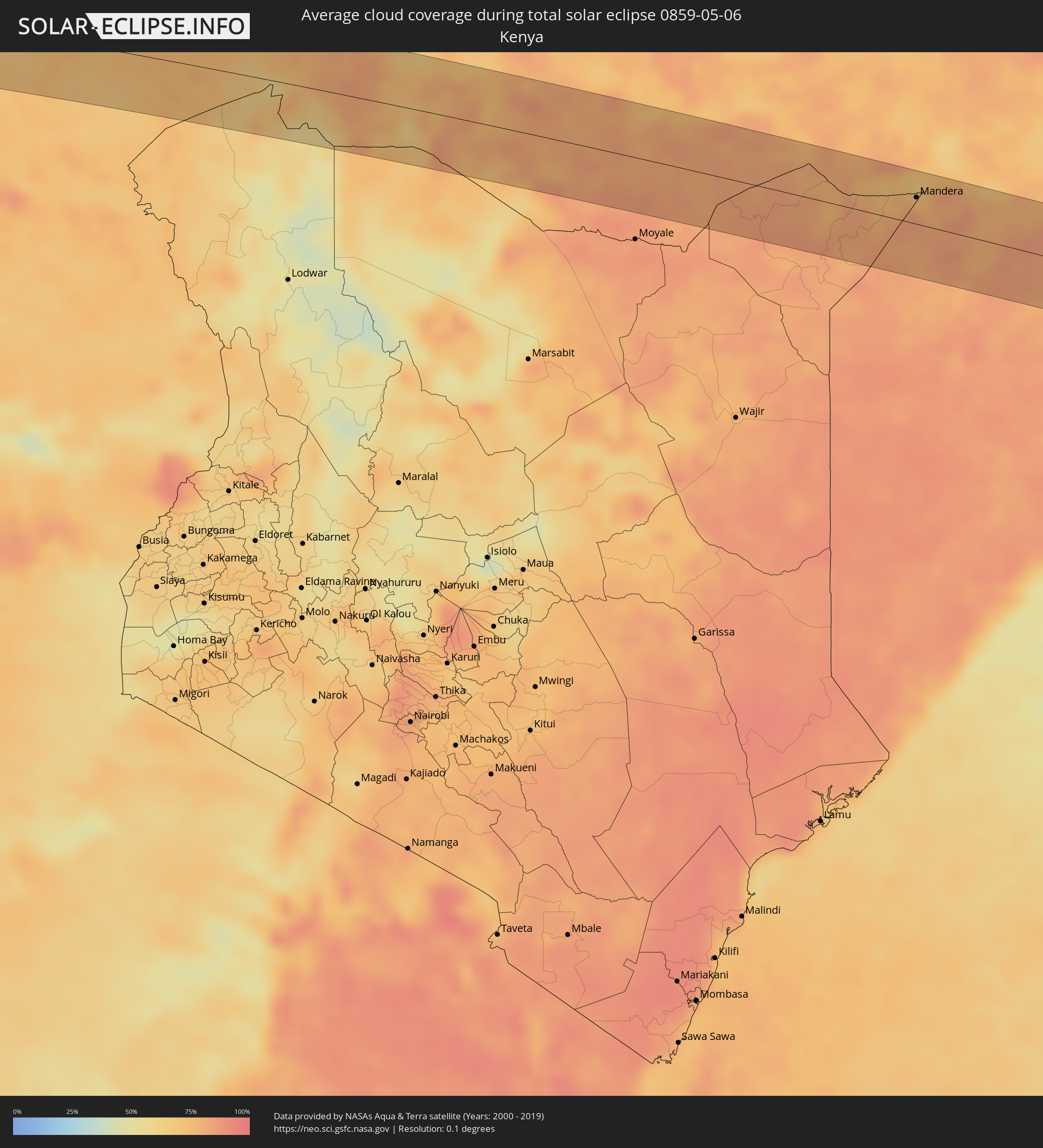 Kenya
Kenya
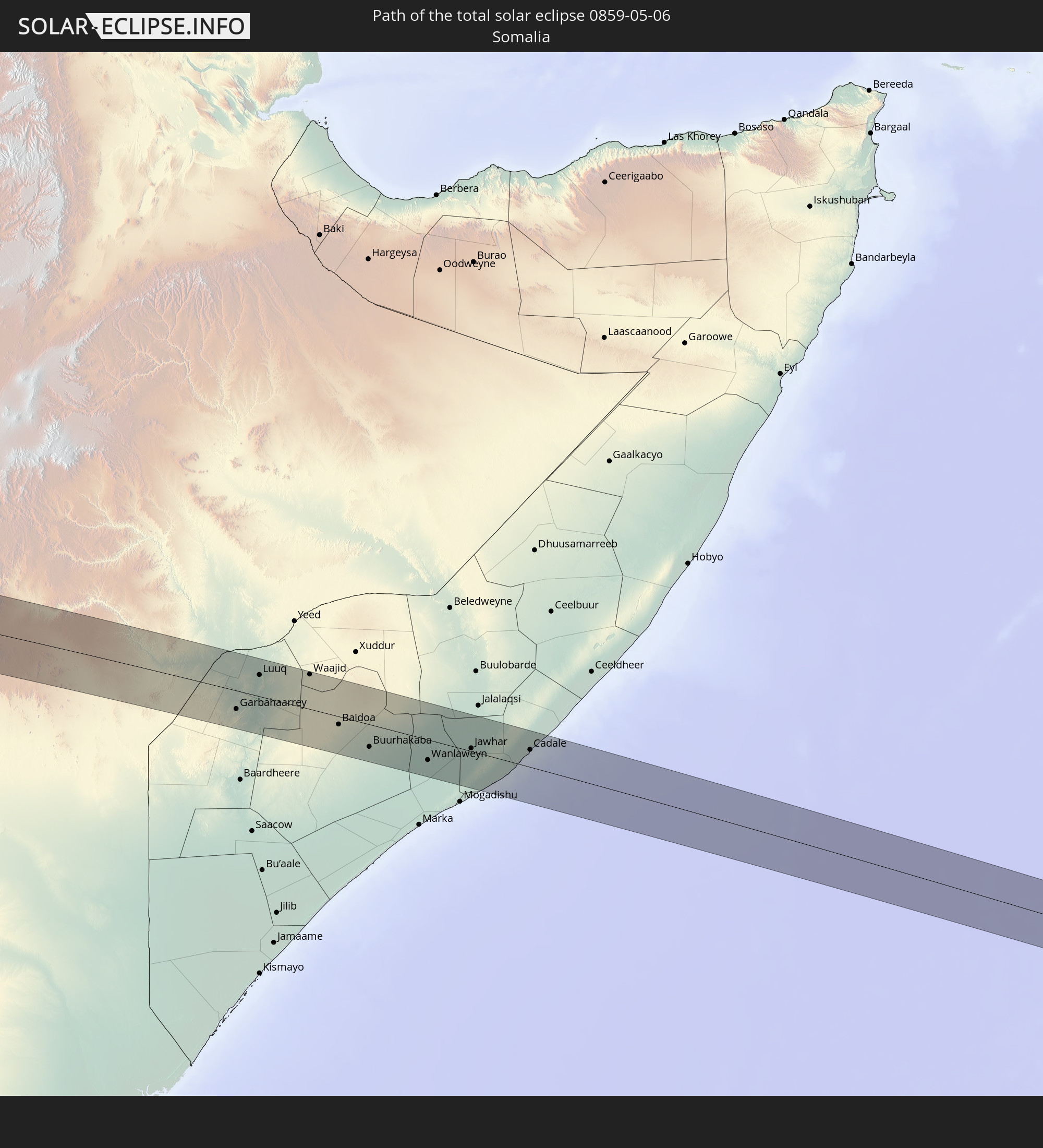
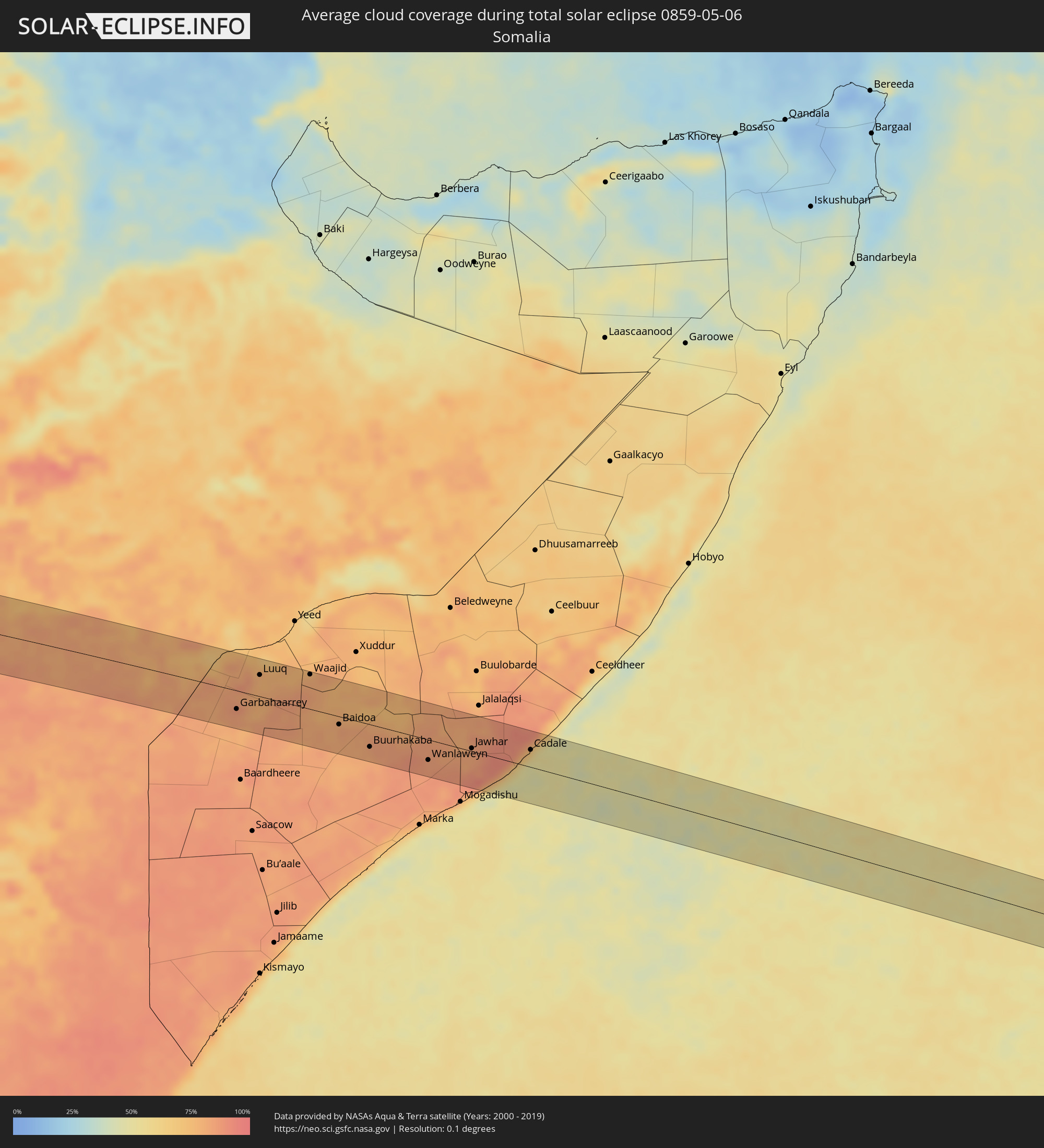 Somalia
Cities inside the path of the eclipse
The following table shows all locations with a population of more than 5,000 inside the eclipse path. Cities which have more than 100,000 inhabitants are marked bold. A click at the locations opens a detailed map.
| City | Type | Eclipse duration | Local time of max. eclipse | Distance to central line | Ø Cloud coverage |
|
Presidente Prudente, São Paulo
|
total | - | 06:55:34 UTC-03:06 | 11 km | 53% |
|
Tupã, São Paulo
|
total | - | 06:55:40 UTC-03:06 | 22 km | 49% |
|
Birigui, São Paulo
|
total | - | 06:55:37 UTC-03:06 | 39 km | 44% |
|
Penápolis, São Paulo
|
total | - | 06:55:41 UTC-03:06 | 16 km | 45% |
|
Lins, São Paulo
|
total | - | 06:55:46 UTC-03:06 | 23 km | 48% |
|
Catanduva, São Paulo
|
total | - | 06:55:52 UTC-03:06 | 5 km | 45% |
|
Taquaritinga, São Paulo
|
total | - | 06:56:00 UTC-03:06 | 40 km | 43% |
|
Bebedouro, São Paulo
|
total | - | 06:55:58 UTC-03:06 | 6 km | 40% |
|
Jaboticabal, São Paulo
|
total | - | 06:56:01 UTC-03:06 | 31 km | 46% |
|
Sertãozinho, São Paulo
|
total | - | 06:56:06 UTC-03:06 | 32 km | 41% |
|
Orlândia, São Paulo
|
total | - | 06:56:05 UTC-03:06 | 8 km | 44% |
|
São Joaquim da Barra, São Paulo
|
total | - | 06:56:05 UTC-03:06 | 21 km | 43% |
|
Ribeirão Preto, São Paulo
|
total | - | 06:56:08 UTC-03:06 | 43 km | 42% |
|
Batatais, São Paulo
|
total | - | 06:56:10 UTC-03:06 | 21 km | 42% |
|
Franca, São Paulo
|
total | - | 06:56:12 UTC-03:06 | 8 km | 43% |
|
Passos, Minas Gerais
|
total | - | 06:56:26 UTC-03:06 | 40 km | 40% |
|
Lagoa da Prata, Minas Gerais
|
total | - | 06:56:43 UTC-03:06 | 9 km | 45% |
|
Pará de Minas, Minas Gerais
|
total | - | 06:57:02 UTC-03:06 | 29 km | 45% |
|
Esmeraldas, Minas Gerais
|
total | - | 06:57:09 UTC-03:06 | 31 km | 45% |
|
Sete Lagoas, Minas Gerais
|
total | - | 06:57:10 UTC-03:06 | 3 km | 44% |
|
Ribeirão das Neves, Minas Gerais
|
total | - | 06:57:14 UTC-03:06 | 40 km | 48% |
|
Pedro Leopoldo, Minas Gerais
|
total | - | 06:57:15 UTC-03:06 | 27 km | 43% |
|
Vespasiano, Minas Gerais
|
total | - | 06:57:17 UTC-03:06 | 39 km | 46% |
|
Governador Valadares, Minas Gerais
|
total | - | 06:58:08 UTC-03:06 | 33 km | 70% |
|
Nova Viçosa, Bahia
|
total | - | 07:31:58 UTC-02:34 | 42 km | 54% |
|
Yenagoa, Bayelsa
|
total | - | 12:04:33 UTC+00:13 | 28 km | 90% |
|
Ahoada, Rivers
|
total | - | 12:05:56 UTC+00:13 | 33 km | 95% |
|
Degema Hulk, Rivers
|
total | - | 12:05:57 UTC+00:13 | 4 km | 94% |
|
Obonoma, Rivers
|
total | - | 12:06:02 UTC+00:13 | 11 km | 94% |
|
Elele, Rivers
|
total | - | 12:06:29 UTC+00:13 | 30 km | 96% |
|
Buguma, Rivers
|
total | - | 12:06:18 UTC+00:13 | 10 km | 94% |
|
Port Harcourt, Rivers
|
total | - | 12:06:49 UTC+00:13 | 11 km | 95% |
|
Owerri, Imo
|
total | - | 12:07:33 UTC+00:13 | 65 km | 97% |
|
Okrika, Rivers
|
total | - | 12:07:01 UTC+00:13 | 16 km | 94% |
|
Bonny, Rivers
|
total | - | 12:07:02 UTC+00:13 | 50 km | 88% |
|
Bori, Rivers
|
total | - | 12:07:52 UTC+00:13 | 32 km | 97% |
|
Aba, Abia
|
total | - | 12:08:16 UTC+00:13 | 14 km | 97% |
|
Umuahia, Abia
|
total | - | 12:09:04 UTC+00:13 | 56 km | 97% |
|
Bende, Abia
|
total | - | 12:09:33 UTC+00:13 | 55 km | 95% |
|
Ikot Ekpene, Akwa Ibom
|
total | - | 12:09:28 UTC+00:13 | 12 km | 97% |
|
Abak, Akwa Ibom
|
total | - | 12:09:32 UTC+00:13 | 11 km | 97% |
|
Ohafia-Ifigh, Abia
|
total | - | 12:10:10 UTC+00:13 | 56 km | 96% |
|
Eket, Akwa Ibom
|
total | - | 12:09:39 UTC+00:13 | 52 km | 87% |
|
Uyo, Akwa Ibom
|
total | - | 12:10:03 UTC+00:13 | 8 km | 97% |
|
Itu, Akwa Ibom
|
total | - | 12:10:21 UTC+00:13 | 7 km | 94% |
|
Ugep, Cross River
|
total | - | 12:11:13 UTC+00:13 | 70 km | 95% |
|
Esuk Oron, Akwa Ibom
|
total | - | 12:10:52 UTC+00:13 | 43 km | 90% |
|
Calabar, Cross River
|
total | - | 12:11:15 UTC+00:13 | 29 km | 93% |
|
Ikang, Cross River
|
total | - | 12:11:46 UTC+00:13 | 52 km | 89% |
|
Ikom, Cross River
|
total | - | 12:13:21 UTC+00:13 | 70 km | 89% |
|
Mundemba, South-West
|
total | - | 12:13:00 UTC+00:13 | 44 km | 93% |
|
Mamfe, South-West
|
total | - | 12:15:07 UTC+00:13 | 32 km | 88% |
|
Batibo, North-West
|
total | - | 12:16:55 UTC+00:13 | 28 km | 89% |
|
Fontem, South-West
|
total | - | 12:16:43 UTC+00:13 | 13 km | 93% |
|
Nkongsamba, Littoral
|
total | - | 12:16:28 UTC+00:13 | 70 km | 89% |
|
Melong, Littoral
|
total | - | 12:16:41 UTC+00:13 | 53 km | 81% |
|
Mbengwi, North-West
|
total | - | 12:17:32 UTC+00:13 | 44 km | 80% |
|
Bali, North-West
|
total | - | 12:17:28 UTC+00:13 | 30 km | 84% |
|
Dschang, West
|
total | - | 12:17:14 UTC+00:13 | 20 km | 89% |
|
Bamenda, North-West
|
total | - | 12:17:57 UTC+00:13 | 34 km | 78% |
|
Bafang, West
|
total | - | 12:17:24 UTC+00:13 | 54 km | 88% |
|
Babanki, North-West
|
total | - | 12:18:25 UTC+00:13 | 49 km | 84% |
|
Belo, North-West
|
total | - | 12:18:25 UTC+00:13 | 51 km | 84% |
|
Mbouda, West
|
total | - | 12:18:02 UTC+00:13 | 4 km | 79% |
|
Fundong, North-West
|
total | - | 12:18:34 UTC+00:13 | 63 km | 86% |
|
Njinikom, North-West
|
total | - | 12:18:37 UTC+00:13 | 61 km | 84% |
|
Bafoussam, West
|
total | - | 12:18:26 UTC+00:13 | 24 km | 82% |
|
Bazou, West
|
total | - | 12:18:16 UTC+00:13 | 71 km | 85% |
|
Bangangté, West
|
total | - | 12:18:31 UTC+00:13 | 63 km | 85% |
|
Foumbot, West
|
total | - | 12:19:09 UTC+00:13 | 26 km | 82% |
|
Kumbo, North-West
|
total | - | 12:19:48 UTC+00:13 | 49 km | 75% |
|
Foumban, West
|
total | - | 12:20:10 UTC+00:13 | 8 km | 80% |
|
Tibati, Adamaoua
|
total | - | 12:26:10 UTC+00:13 | 40 km | 81% |
|
Meïganga, Adamaoua
|
total | - | 12:31:22 UTC+00:13 | 20 km | 79% |
|
Garoua Boulaï, East
|
total | - | 12:31:45 UTC+00:13 | 53 km | 81% |
|
Bouar, Nana-Mambéré
|
total | - | 12:34:58 UTC+00:13 | 60 km | 79% |
|
Bozoum, Ouham-Pendé
|
total | - | 12:37:32 UTC+00:13 | 24 km | 78% |
|
Bossangoa, Ouham
|
total | - | 12:40:46 UTC+00:13 | 13 km | 76% |
|
Bouca, Ouham
|
total | - | 12:43:08 UTC+00:13 | 16 km | 79% |
|
Kaga Bandoro, Nana-Grébizi
|
total | - | 12:45:55 UTC+00:13 | 34 km | 77% |
|
Ippy, Ouaka
|
total | - | 12:51:11 UTC+00:13 | 48 km | 82% |
|
Bria, Haute-Kotto
|
total | - | 12:53:17 UTC+00:13 | 16 km | 77% |
 Bor, Jonglei
|
total | - | 15:07:29 UTC+02:06 | 47 km | 70% |
|
Yabēlo, Oromiya
|
total | - | 15:38:52 UTC+02:27 | 36 km | 86% |
|
Mēga, Oromiya
|
total | - | 15:39:09 UTC+02:27 | 49 km | 85% |
|
Mandera, Mandera
|
total | - | 15:43:41 UTC+02:27 | 28 km | 75% |
|
Garbahaarrey, Gedo
|
total | - | 15:44:05 UTC+02:27 | 28 km | 84% |
|
Luuq, Gedo
|
total | - | 15:44:28 UTC+02:27 | 32 km | 79% |
|
Waajid, Bakool
|
total | - | 15:45:14 UTC+02:27 | 52 km | 79% |
|
Baidoa, Bay
|
total | - | 15:45:39 UTC+02:27 | 12 km | 80% |
|
Buurhakaba, Bay
|
total | - | 15:46:05 UTC+02:27 | 34 km | 82% |
|
Wanlaweyn, Lower Shabeelle
|
total | - | 15:46:53 UTC+02:27 | 30 km | 85% |
|
Jawhar, Middle Shabele
|
total | - | 15:47:29 UTC+02:27 | 4 km | 84% |
|
Mahaddayweyne, Middle Shabele
|
total | - | 15:47:31 UTC+02:27 | 26 km | 85% |
|
Cadale, Middle Shabele
|
total | - | 15:48:14 UTC+02:27 | 26 km | 71% |