Annular solar eclipse of 05/28/0960
| Day of week: | Wednesday |
| Maximum duration of eclipse: | 06m21s |
| Maximum width of eclipse path: | 185 km |
| Saros cycle: | 101 |
| Coverage: | 95% |
| Magnitude: | 0.9497 |
| Gamma: | -0.0369 |
Wo kann man die Sonnenfinsternis vom 05/28/0960 sehen?
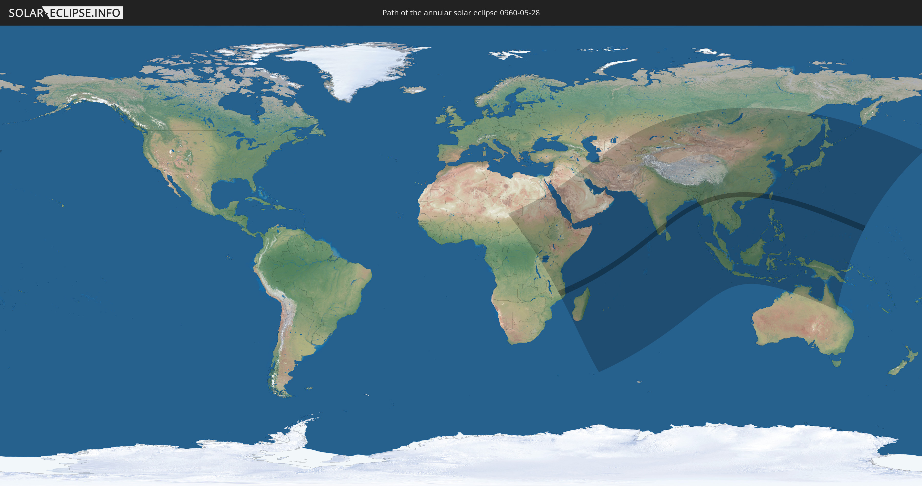
Die Sonnenfinsternis am 05/28/0960 kann man in 71 Ländern als partielle Sonnenfinsternis beobachten.
Der Finsternispfad verläuft durch 14 Länder. Nur in diesen Ländern ist sie als annular Sonnenfinsternis zu sehen.
In den folgenden Ländern ist die Sonnenfinsternis annular zu sehen
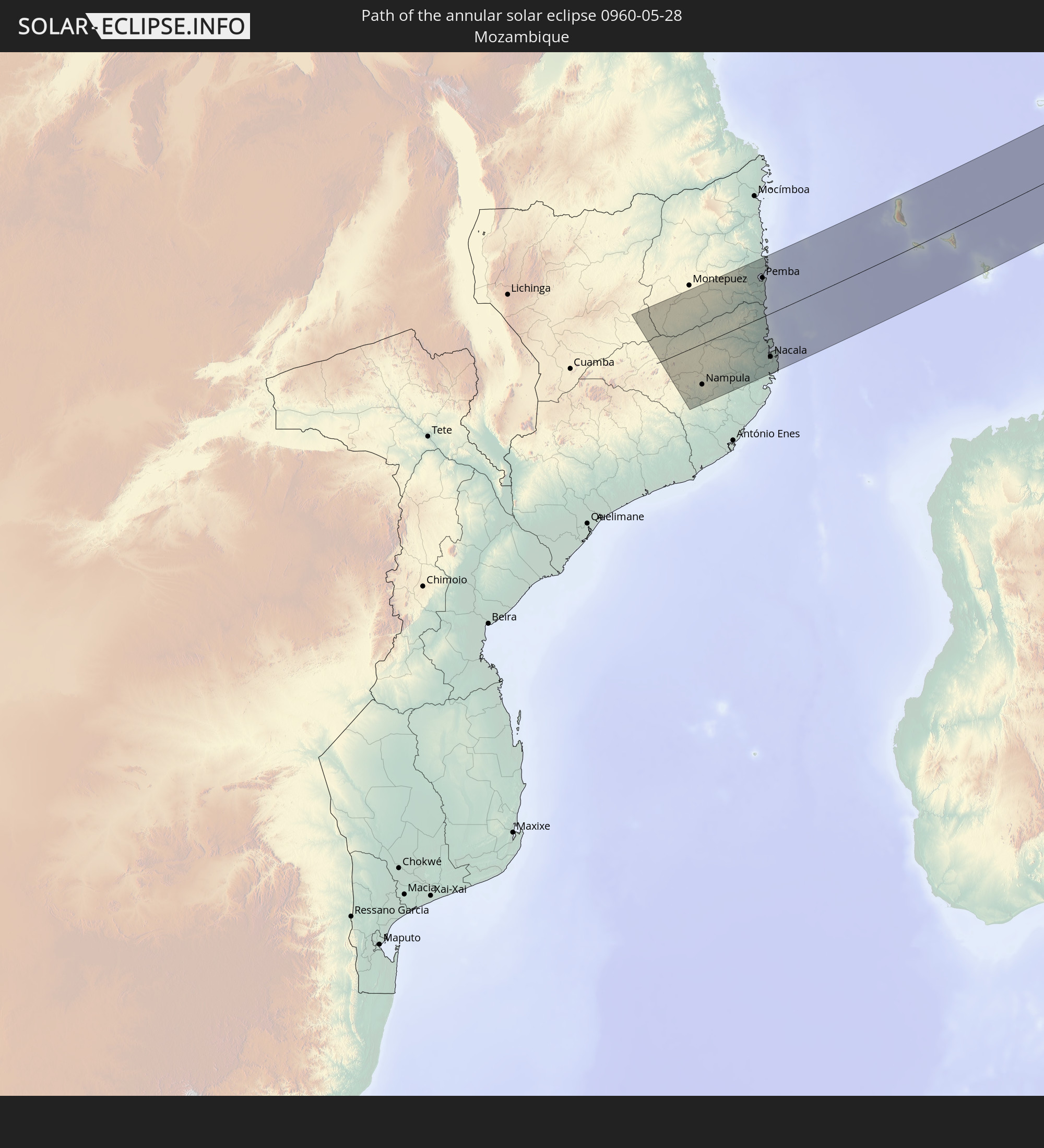 Mozambique
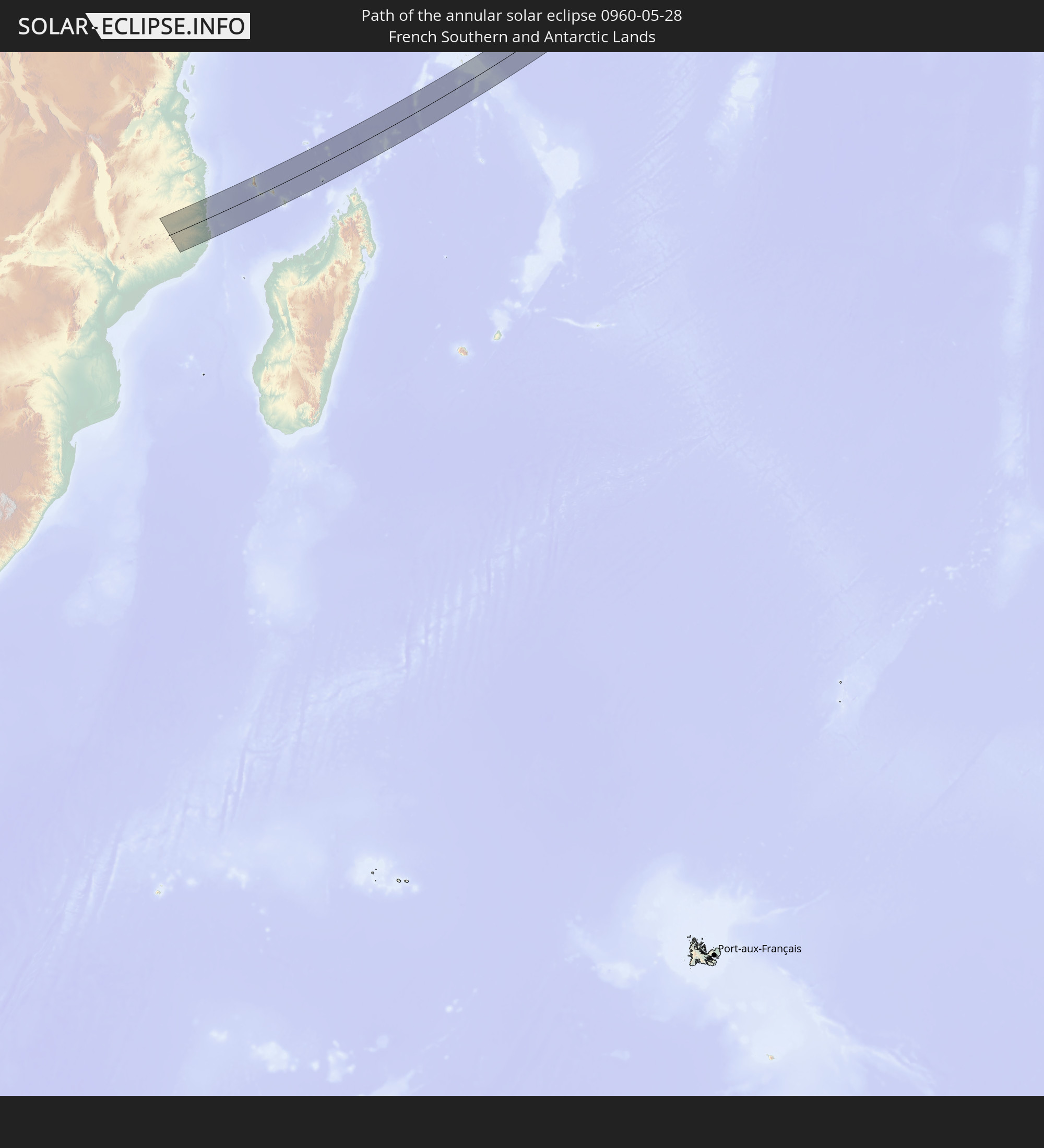 French Southern and Antarctic Lands
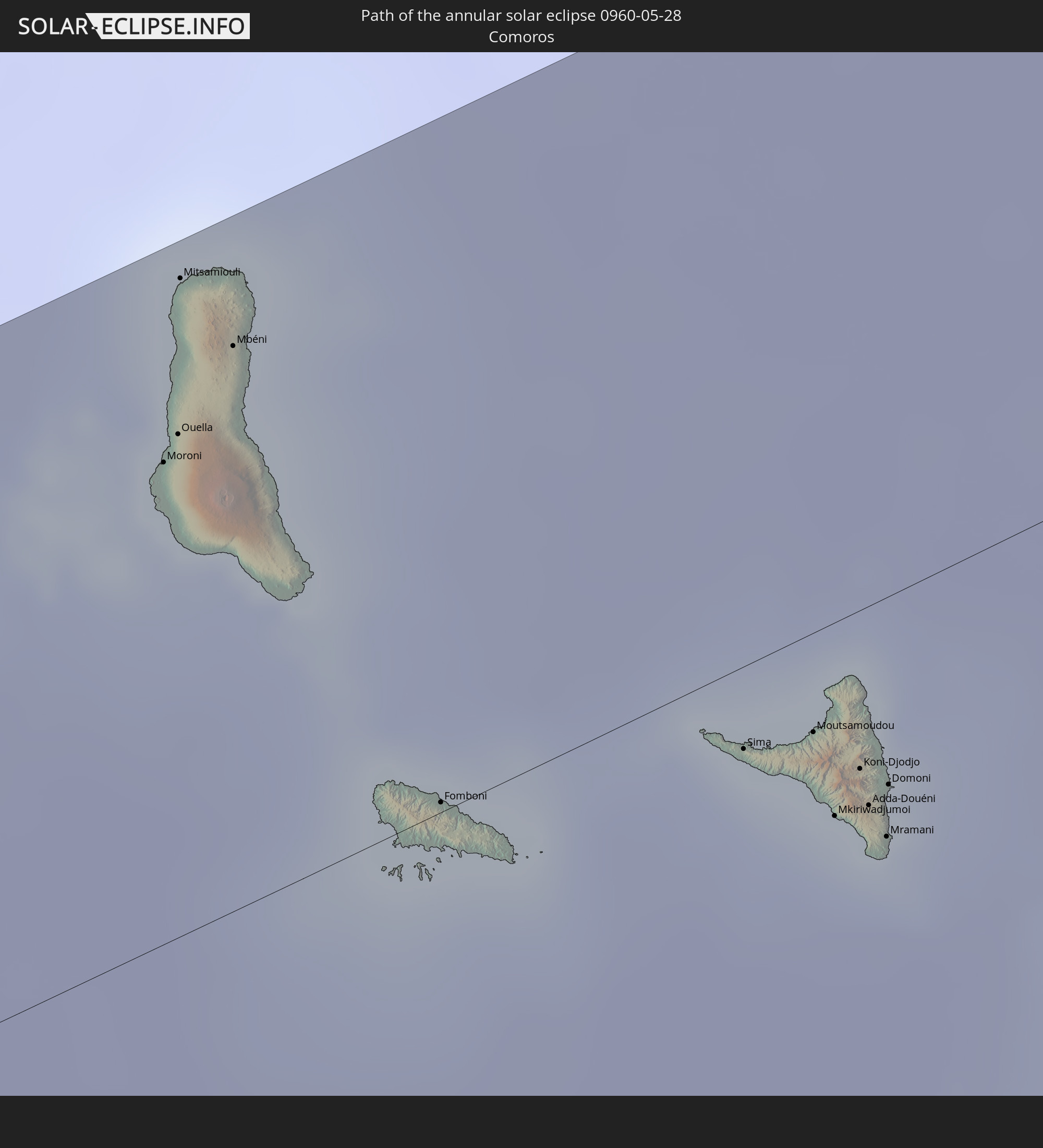 Comoros
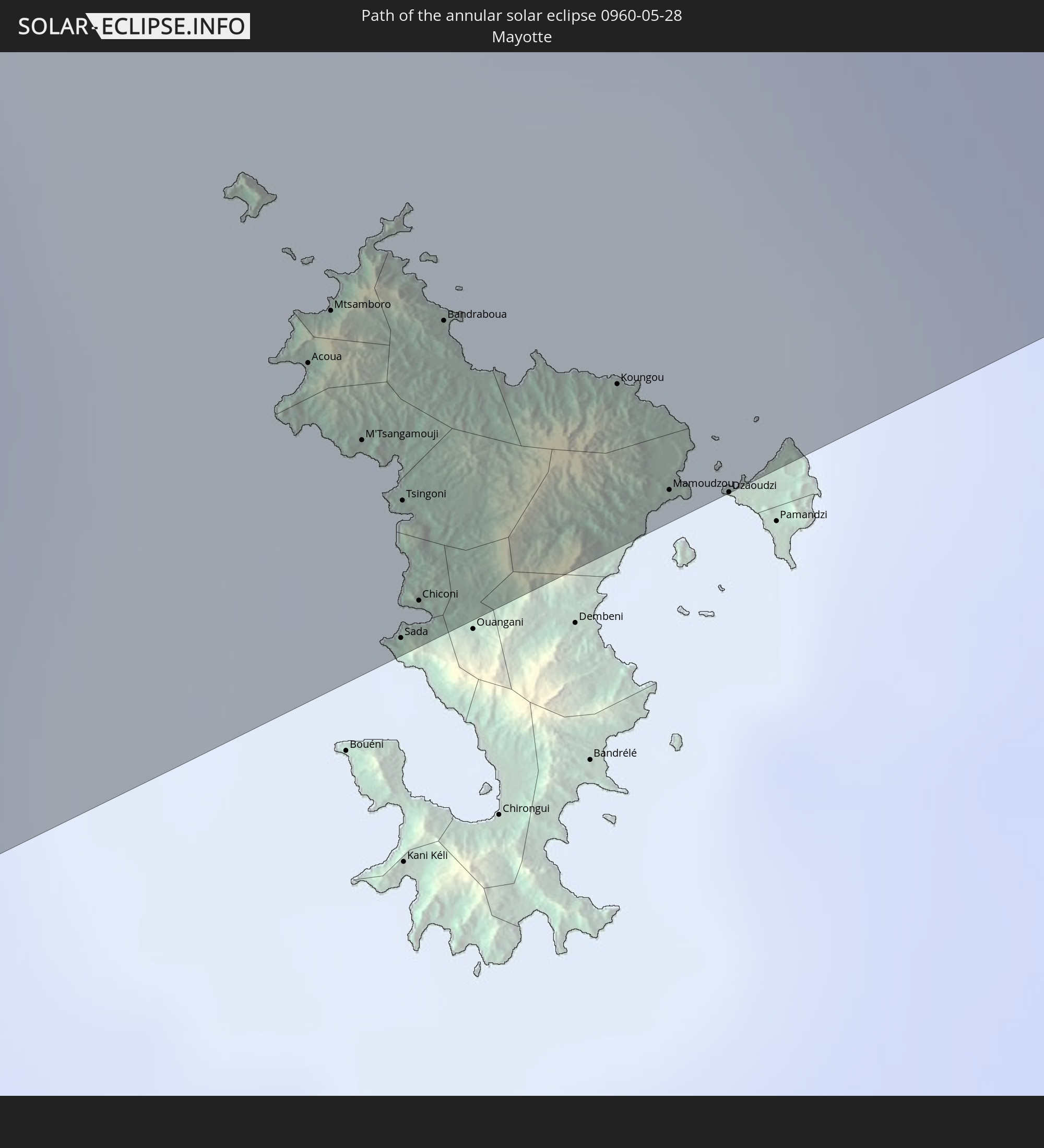 Mayotte
 Seychelles
 India
India
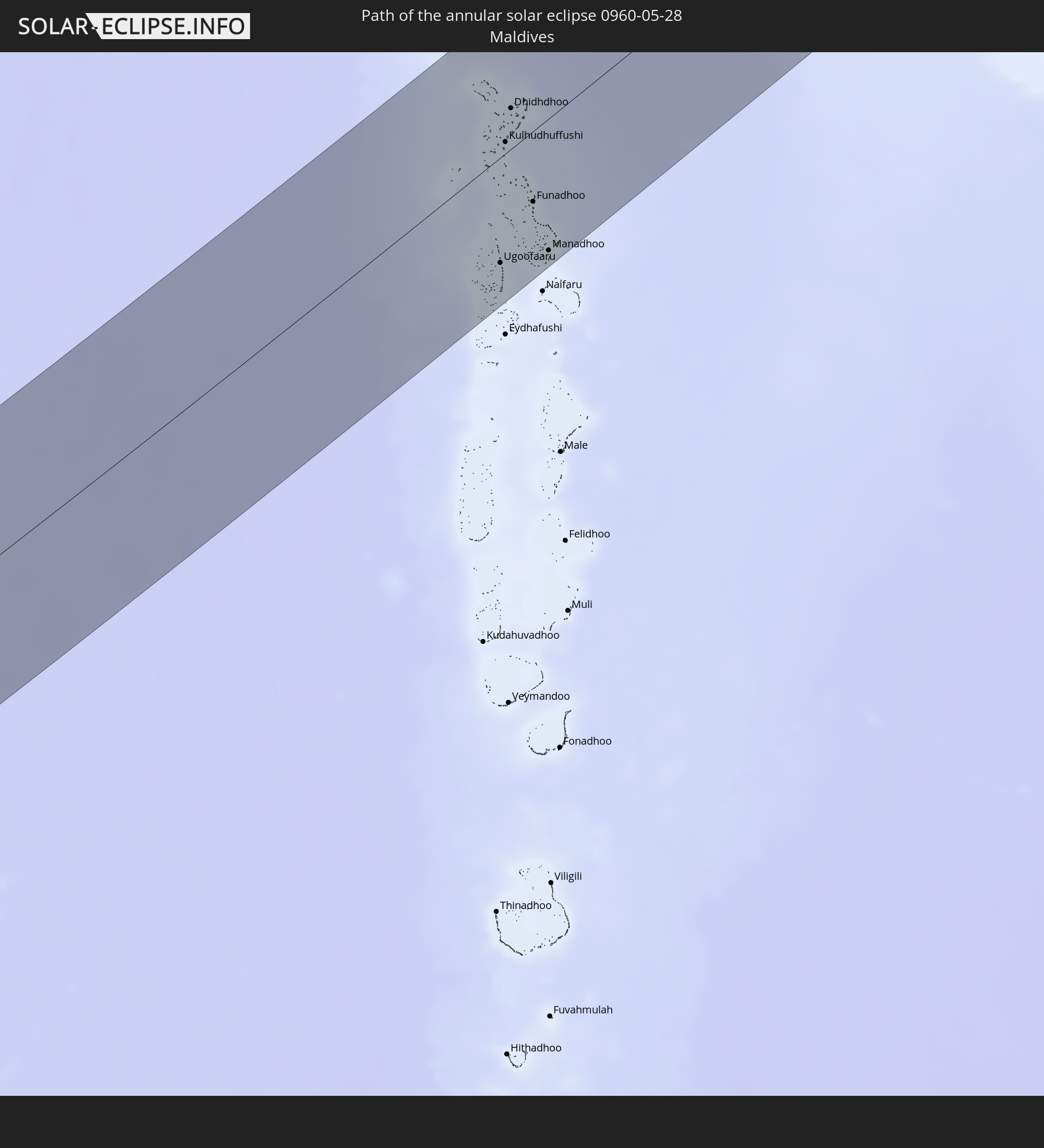 Maldives
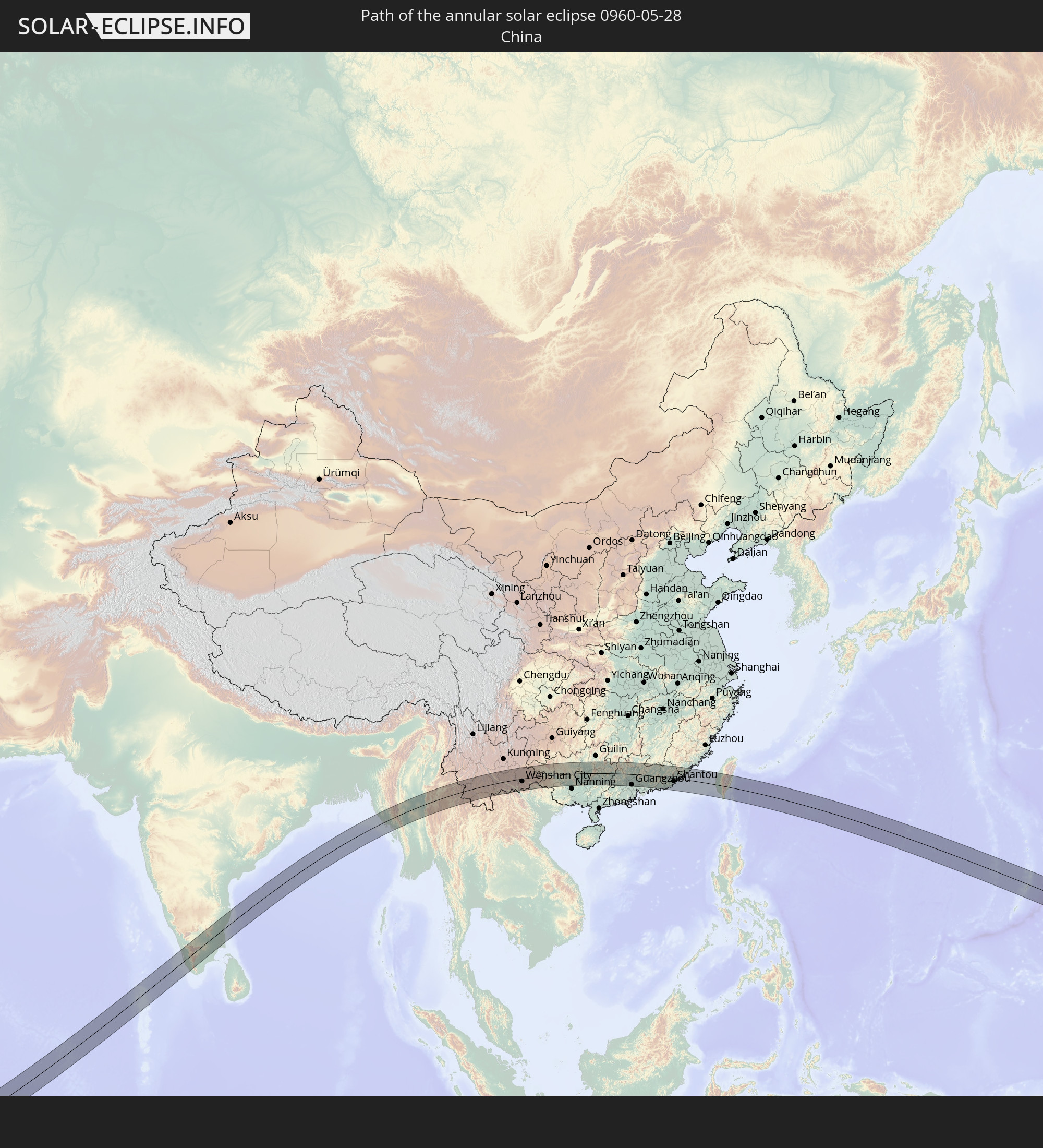 China
China
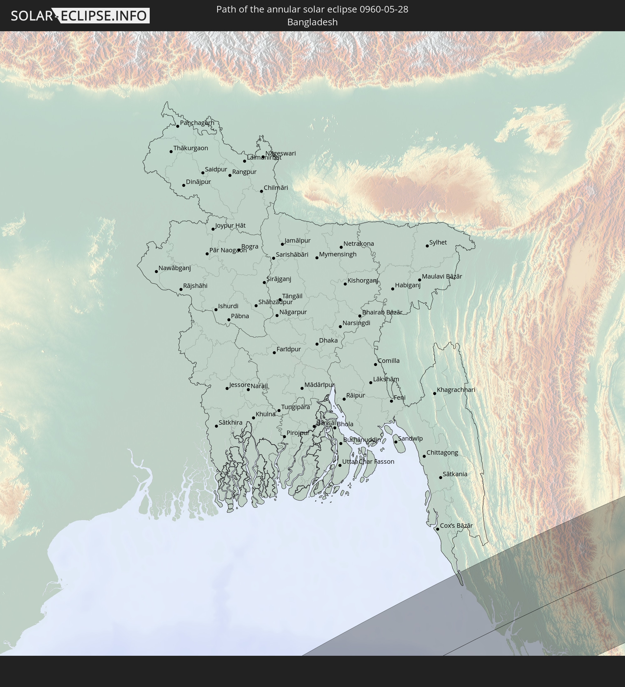 Bangladesh
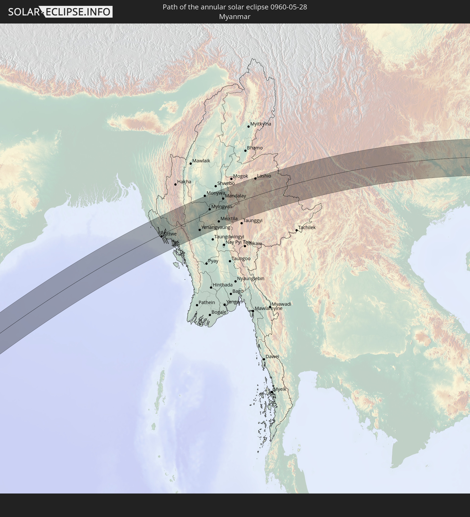 Myanmar
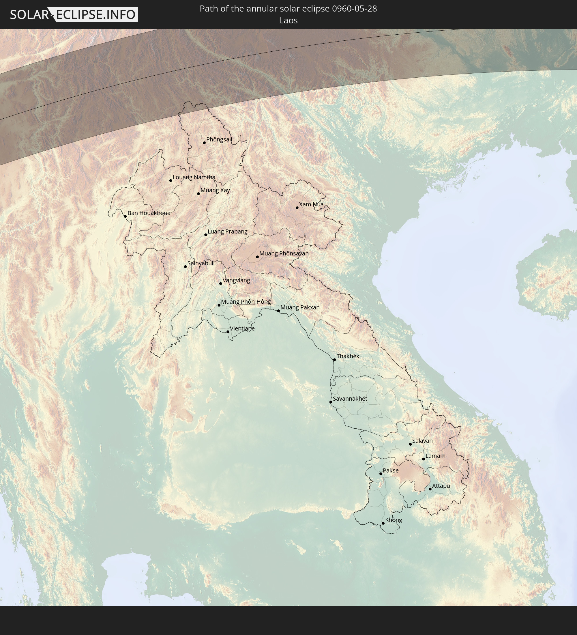 Laos
Laos
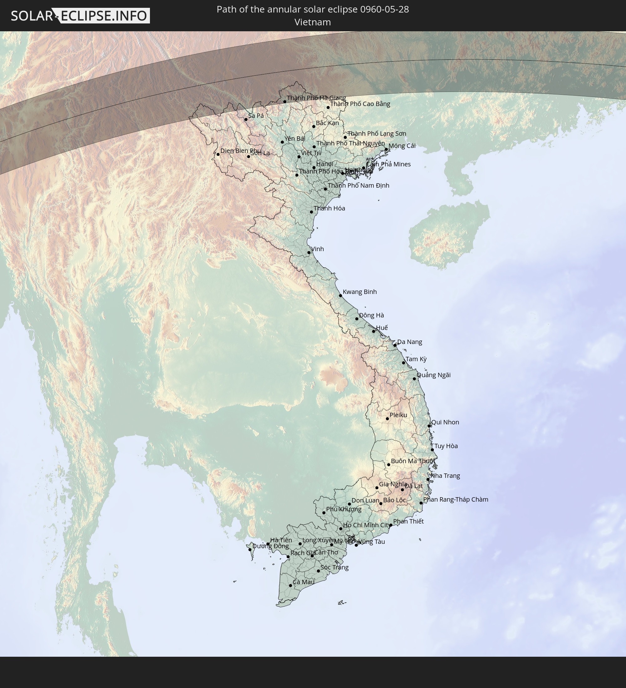 Vietnam
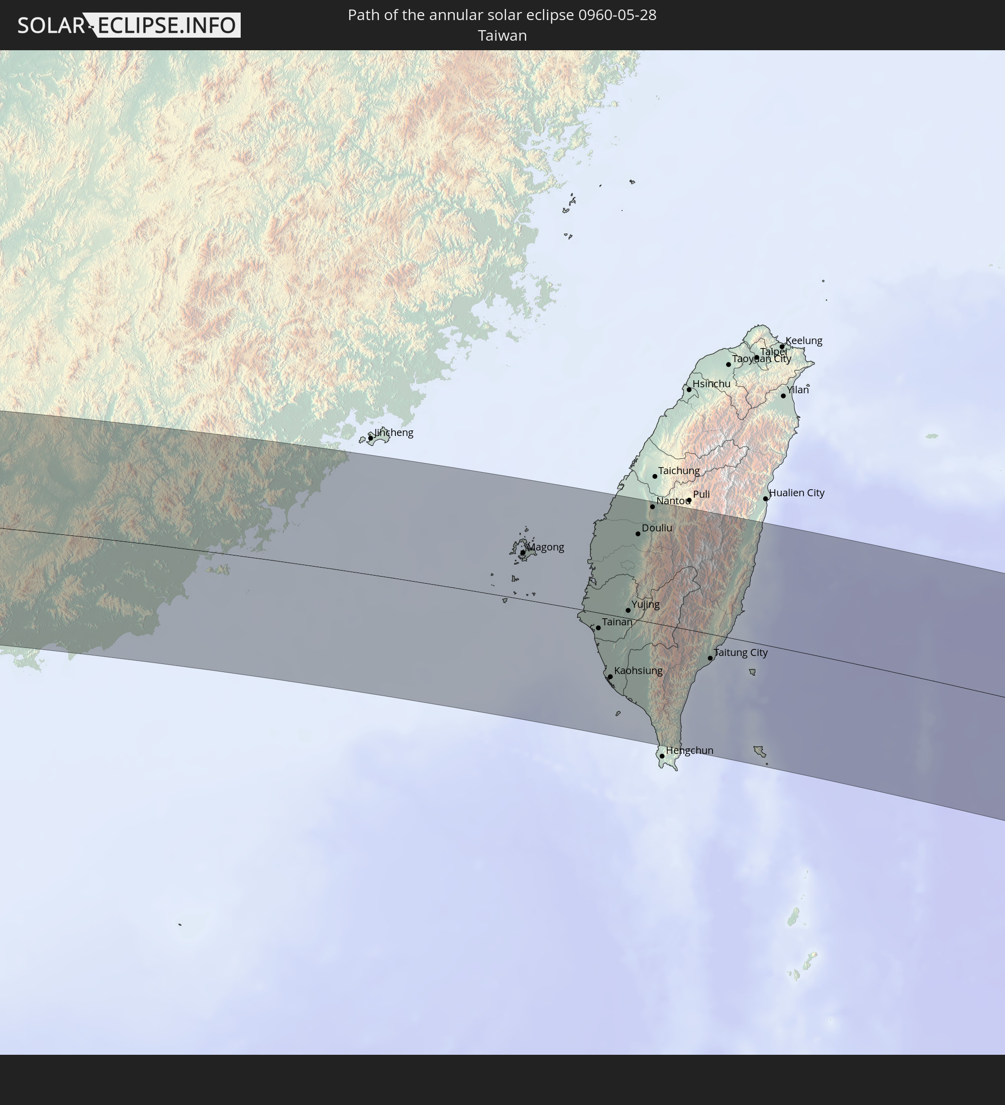 Taiwan
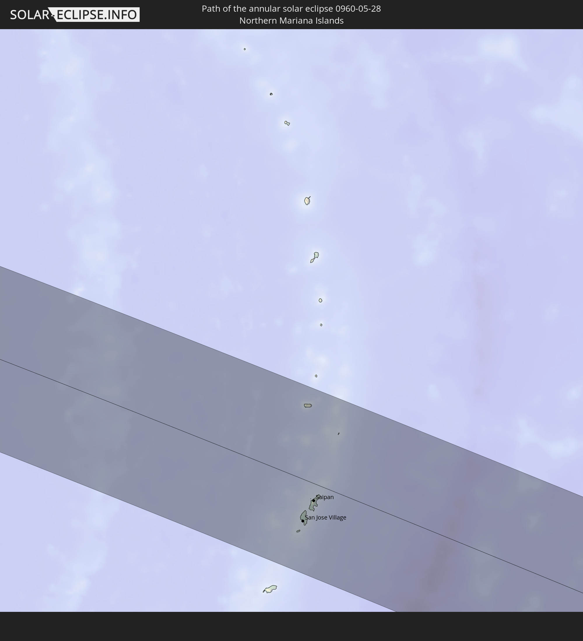 Northern Mariana Islands
In den folgenden Ländern ist die Sonnenfinsternis partiell zu sehen
 Russia
 Democratic Republic of the Congo
 Chad
Chad
 Central African Republic
 Sudan
Sudan
 Egypt
Egypt
 Tanzania
 Uganda
 Mozambique
 Ethiopia
 Kenya
Kenya
 Saudi Arabia
 Eritrea
 Iraq
Iraq
 French Southern and Antarctic Lands
 Somalia
 Djibouti
 Yemen
Yemen
 Madagascar
 Comoros
 Iran
Iran
 Mayotte
 Seychelles
 Kazakhstan
 Kuwait
 Bahrain
 Qatar
Qatar
 United Arab Emirates
 Oman
Oman
 Turkmenistan
 Réunion
 Uzbekistan
 Mauritius
 Afghanistan
 Pakistan
 Tajikistan
 India
India
 Kyrgyzstan
 British Indian Ocean Territory
 Maldives
 China
China
 Sri Lanka
 Nepal
Nepal
 Mongolia
 Bangladesh
 Bhutan
 Myanmar
 Indonesia
 Cocos Islands
 Thailand
 Malaysia
 Laos
Laos
 Vietnam
 Cambodia
 Singapore
 Christmas Island
 Australia
 Macau
Macau
 Hong Kong
 Brunei
 Taiwan
 Philippines
 Japan
Japan
 East Timor
 North Korea
 South Korea
 Palau
Palau
 Federated States of Micronesia
 Papua New Guinea
 Guam
Guam
 Northern Mariana Islands
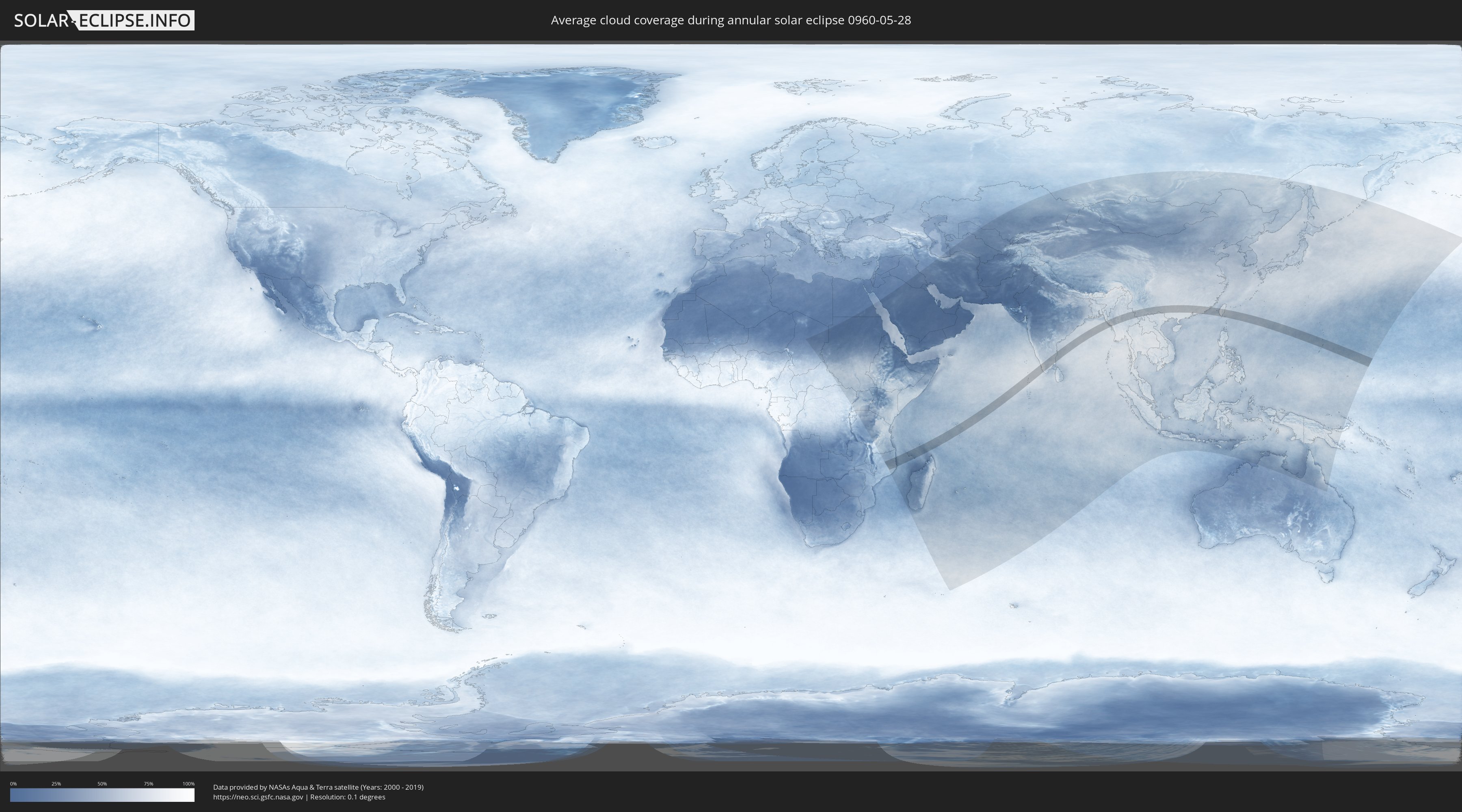
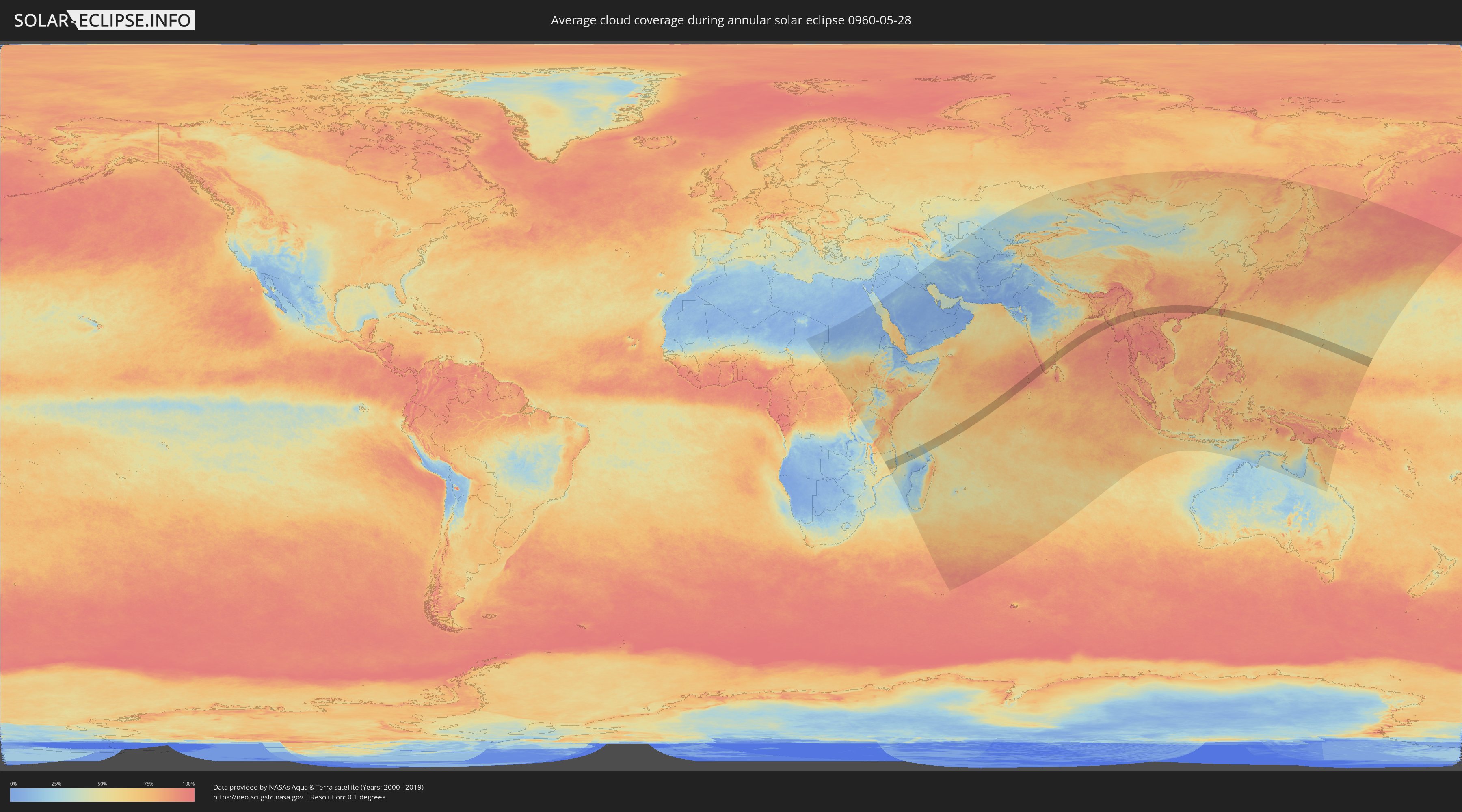
How will be the weather during the annular solar eclipse on 05/28/0960?
Where is the best place to see the annular solar eclipse of 05/28/0960?
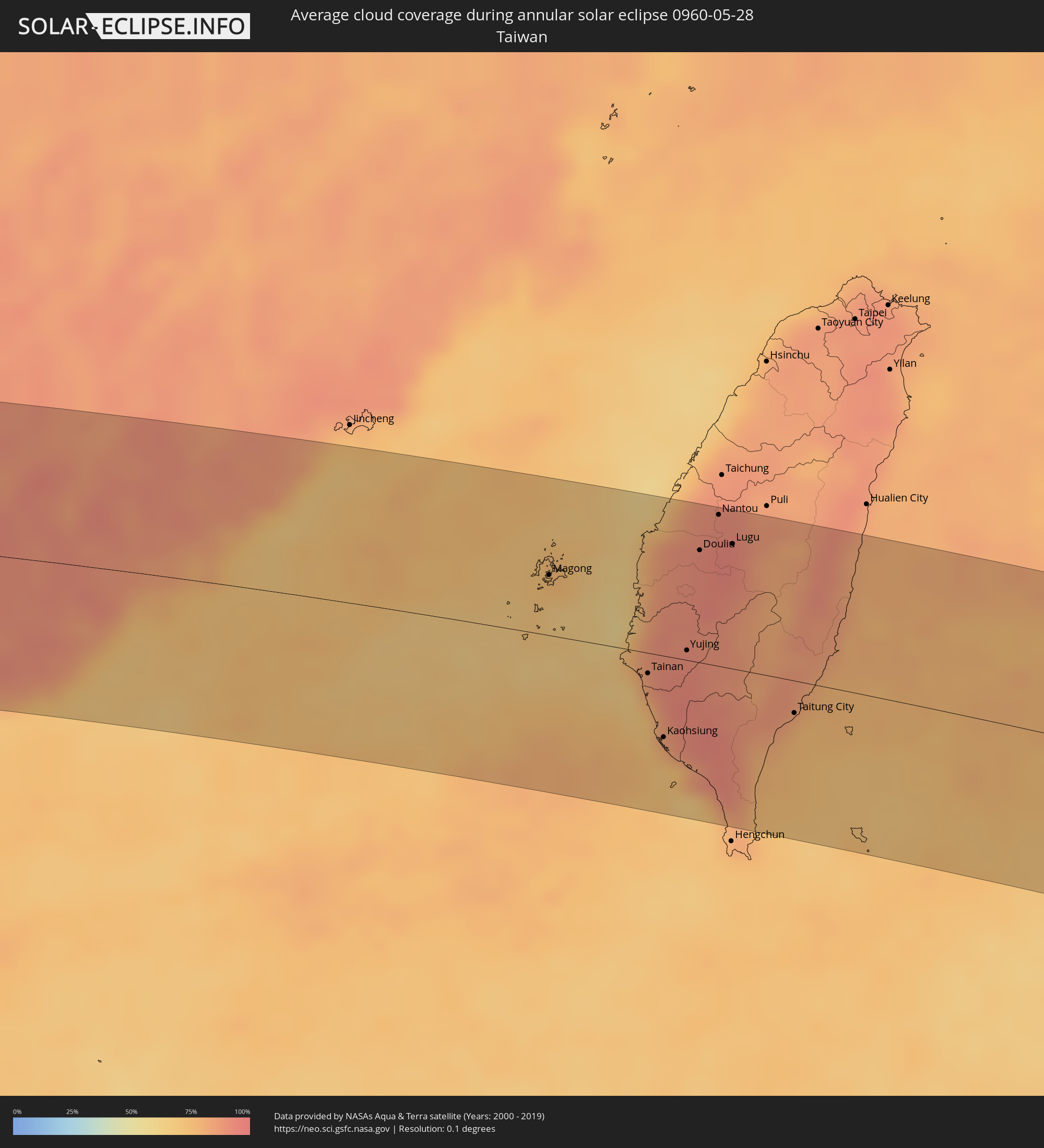
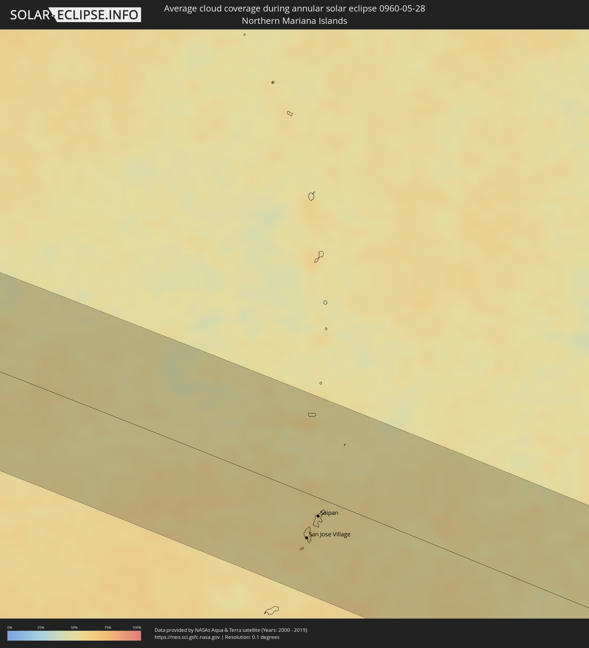
The following maps show the average cloud coverage for the day of the annular solar eclipse.
With the help of these maps, it is possible to find the place along the eclipse path, which has the best
chance of a cloudless sky.
Nevertheless, you should consider local circumstances and inform about the weather of your chosen
observation site.
The data is provided by NASAs satellites
AQUA and TERRA.
The cloud maps are averaged over a period of 19 years (2000 - 2019).
Detailed country maps
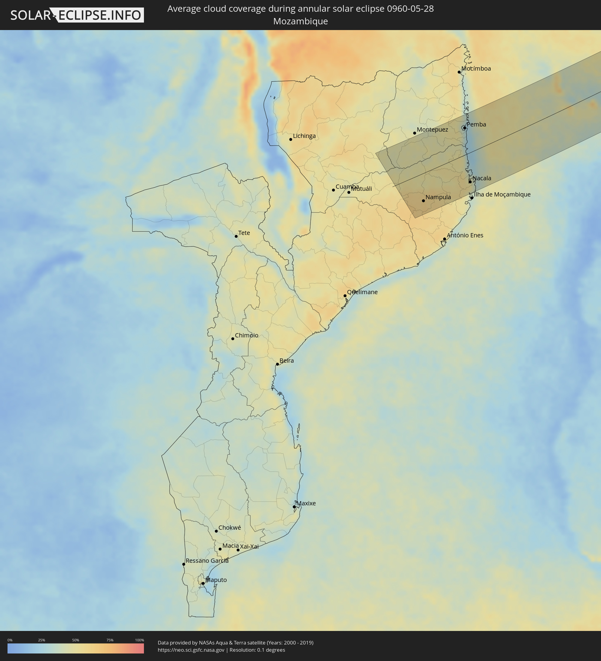 Mozambique
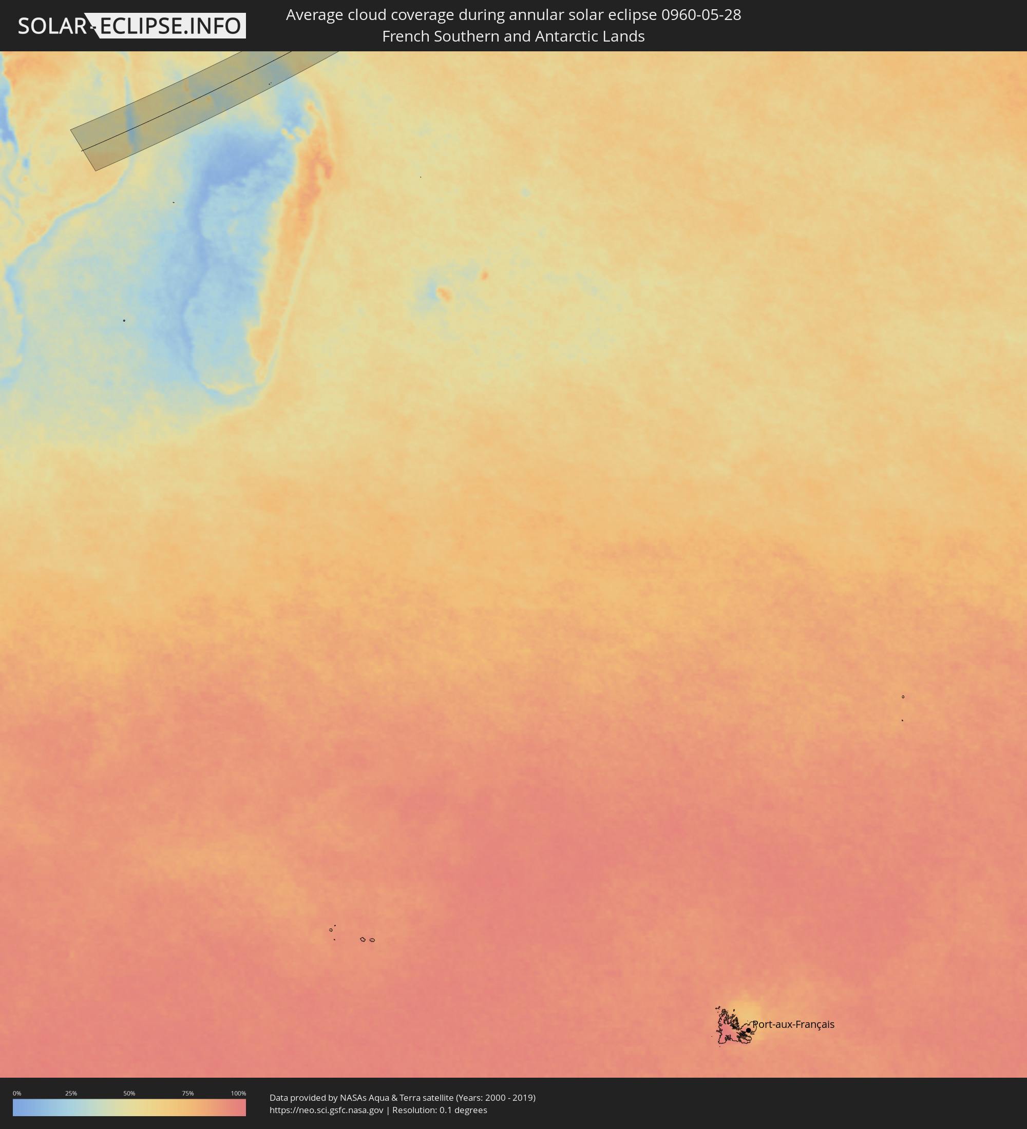 French Southern and Antarctic Lands
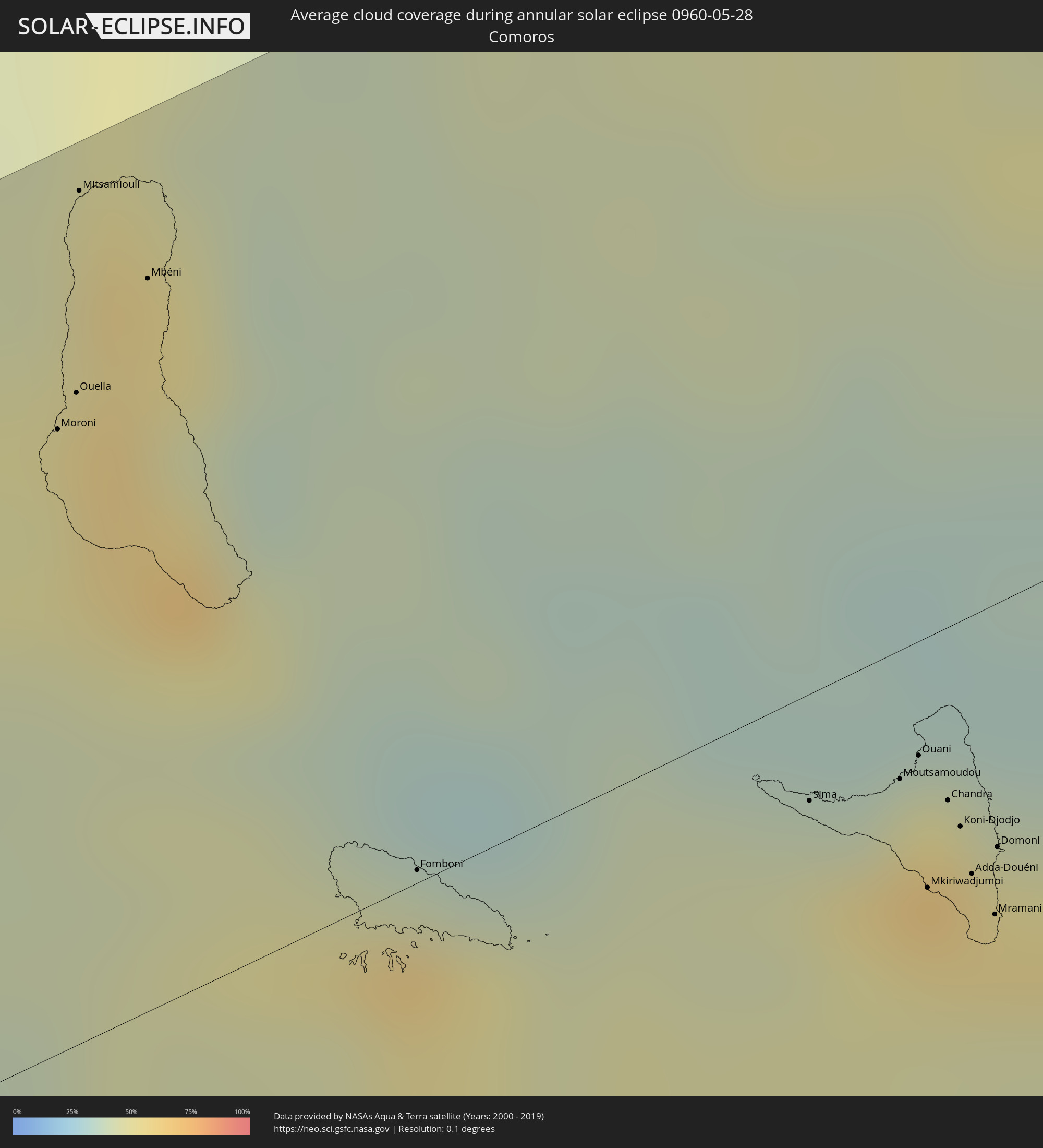 Comoros
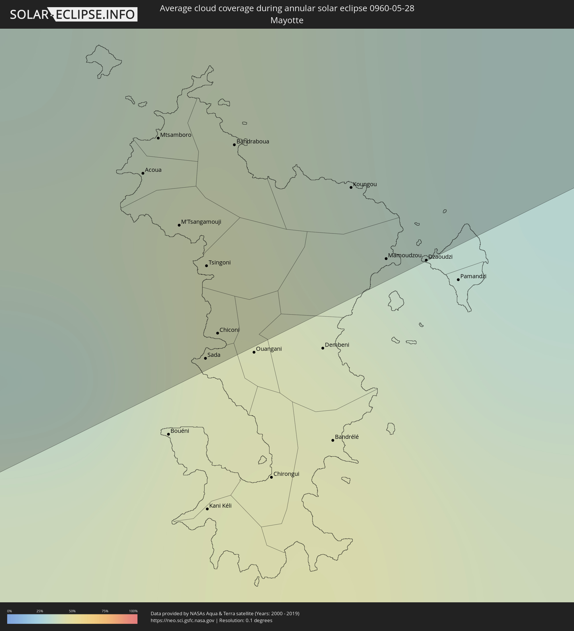 Mayotte
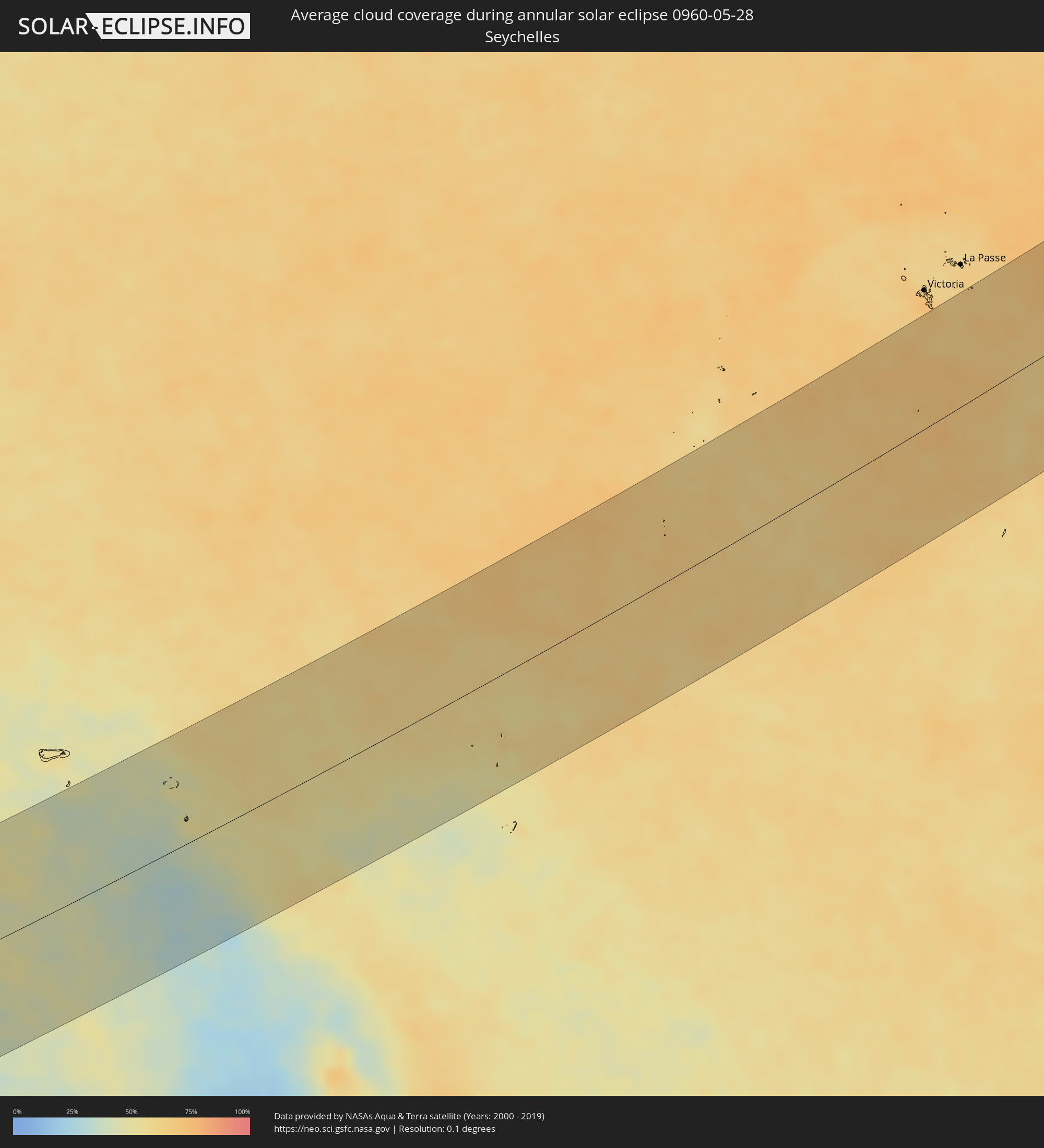 Seychelles
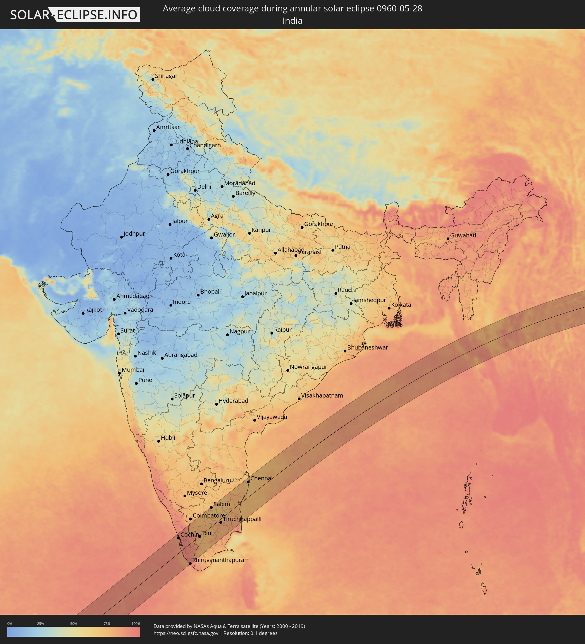 India
India
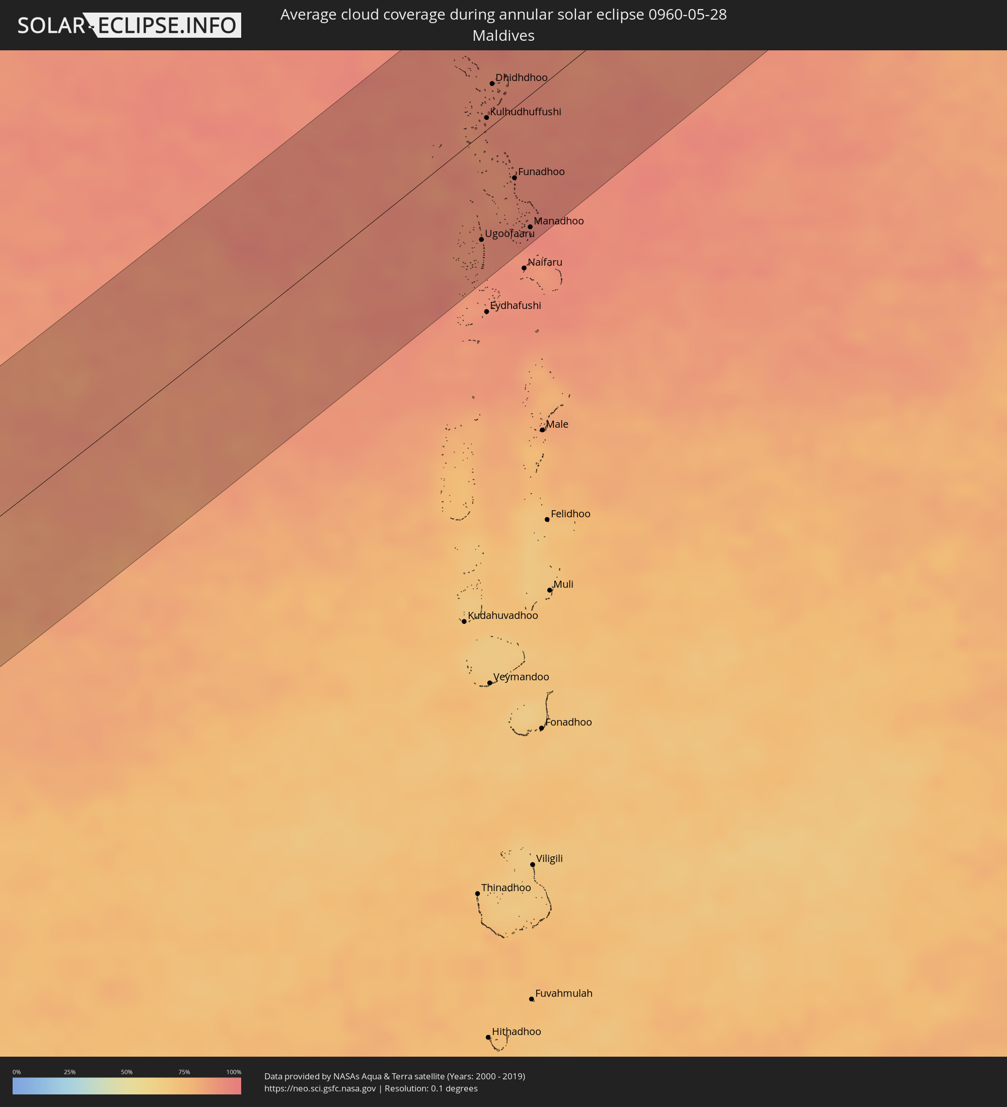 Maldives
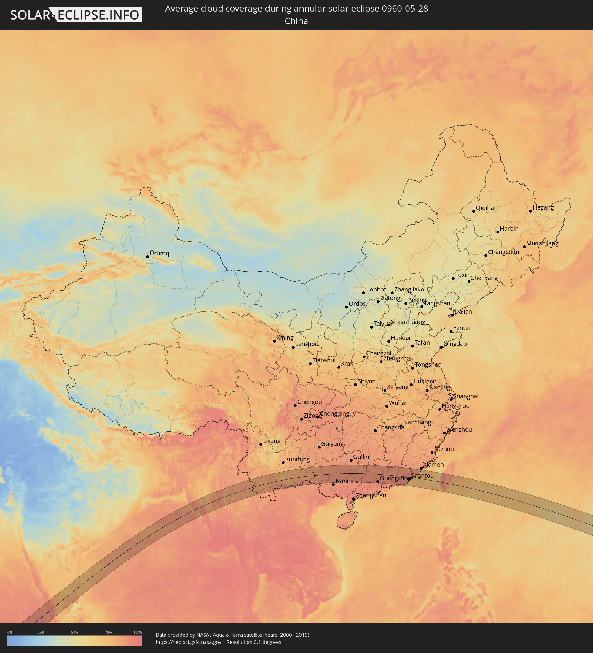 China
China
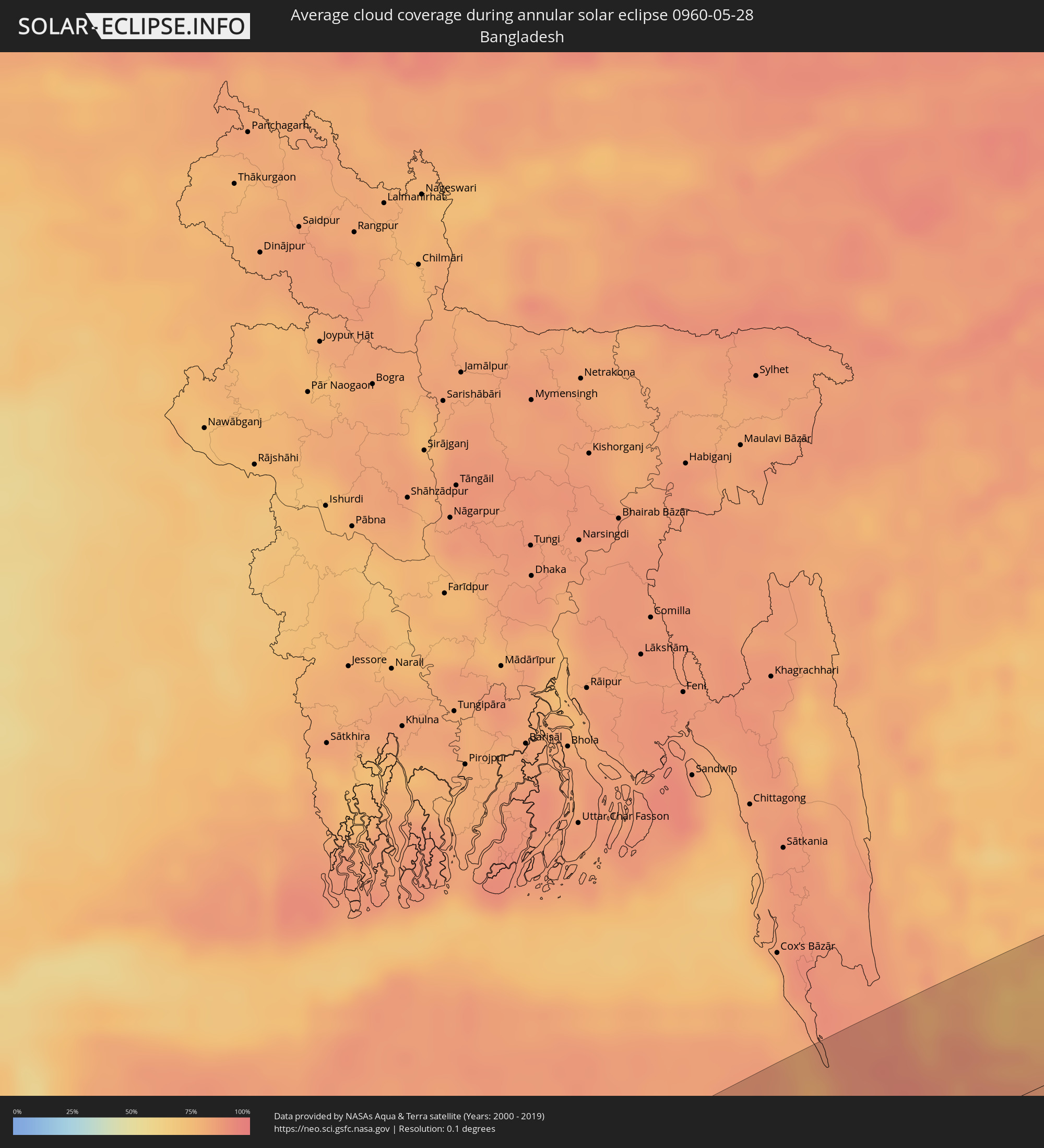 Bangladesh
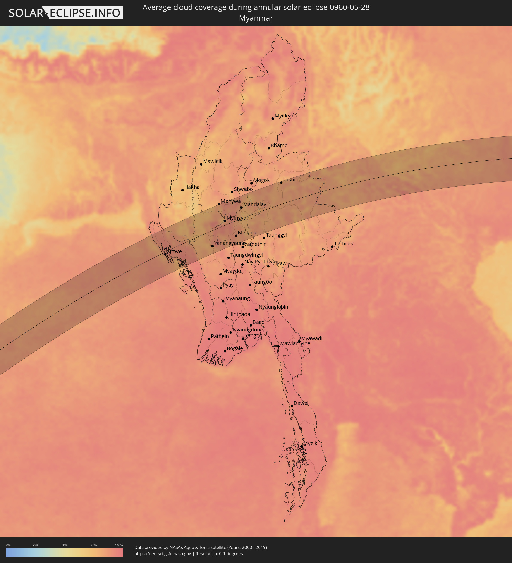 Myanmar
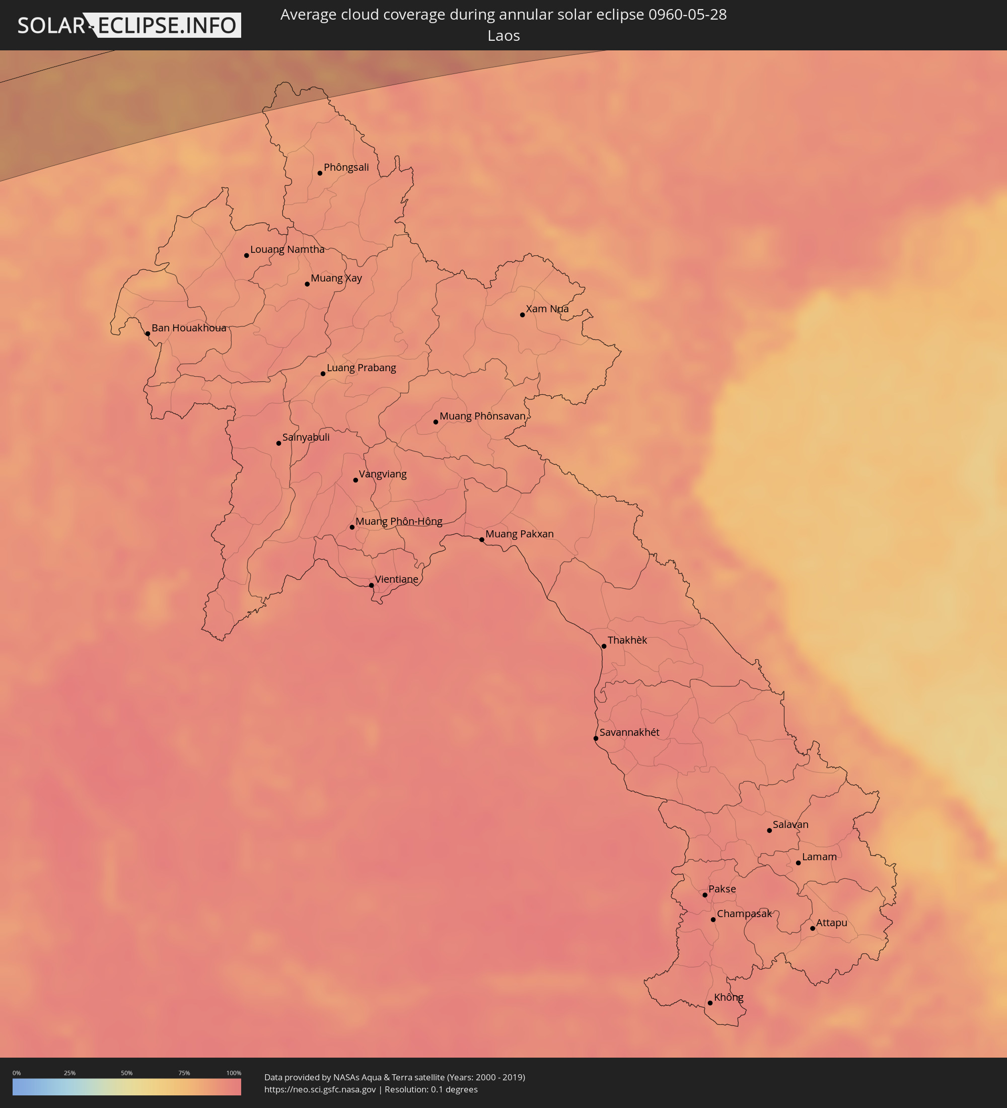 Laos
Laos
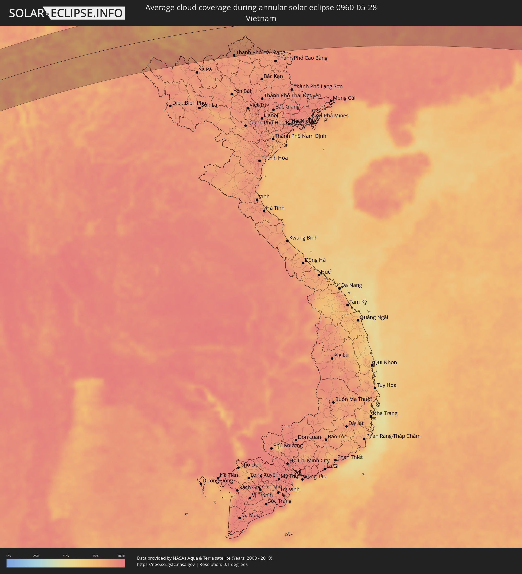 Vietnam
 Taiwan
 Northern Mariana Islands
Cities inside the path of the eclipse
The following table shows all locations with a population of more than 5,000 inside the eclipse path. Cities which have more than 100,000 inhabitants are marked bold. A click at the locations opens a detailed map.
| City | Type | Eclipse duration | Local time of max. eclipse | Distance to central line | Ø Cloud coverage |
|
Nampula, Nampula
|
annular | - | 05:57:10 UTC+02:10 | 84 km | 61% |
|
Pemba, Cabo Delgado
|
annular | - | 05:57:47 UTC+02:10 | 80 km | 34% |
|
Nacala, Nampula
|
annular | - | 05:57:13 UTC+02:10 | 89 km | 51% |
|
Moroni, Grande Comore
|
annular | - | 06:15:13 UTC+02:27 | 83 km | 59% |
|
Ouella, Grande Comore
|
annular | - | 06:15:14 UTC+02:27 | 87 km | 59% |
|
Mitsamiouli, Grande Comore
|
annular | - | 06:15:21 UTC+02:27 | 114 km | 57% |
|
Mbéni, Grande Comore
|
annular | - | 06:15:18 UTC+02:27 | 98 km | 51% |
|
Fomboni, Mohéli
|
annular | - | 06:14:58 UTC+02:27 | 2 km | 60% |
|
Sima, Anjouan
|
annular | - | 06:15:02 UTC+02:27 | 14 km | 54% |
|
Moutsamoudou, Anjouan
|
annular | - | 06:15:03 UTC+02:27 | 17 km | 63% |
|
Mirontsi, Anjouan
|
annular | - | 06:15:04 UTC+02:27 | 17 km | 63% |
|
Ouani, Anjouan
|
annular | - | 06:15:04 UTC+02:27 | 15 km | 49% |
|
Barakani, Anjouan
|
annular | - | 06:15:04 UTC+02:27 | 16 km | 49% |
|
Mkiriwadjumoi
|
annular | - | 06:15:00 UTC+02:27 | 33 km | 54% |
|
Moya, Anjouan
|
annular | - | 06:15:00 UTC+02:27 | 33 km | 54% |
|
Chandra, Anjouan
|
annular | - | 06:15:03 UTC+02:27 | 23 km | 51% |
|
Koni-Djodjo, Anjouan
|
annular | - | 06:15:02 UTC+02:27 | 27 km | 51% |
|
Adda-Douéni, Anjouan
|
annular | - | 06:15:00 UTC+02:27 | 34 km | 54% |
|
Mramani, Anjouan
|
annular | - | 06:14:59 UTC+02:27 | 41 km | 54% |
|
Domoni, Anjouan
|
annular | - | 06:15:01 UTC+02:27 | 32 km | 54% |
|
Acoua, Acoua
|
annular | - | 06:14:51 UTC+02:27 | 104 km | 42% |
|
Mtsamboro, Mtsamboro
|
annular | - | 06:14:52 UTC+02:27 | 102 km | 42% |
|
M'Tsangamouji, M'Tsangamouji
|
annular | - | 06:14:51 UTC+02:27 | 109 km | 43% |
|
Sada, Sada
|
annular | - | 06:14:48 UTC+02:27 | 119 km | 44% |
|
Tsingoni, Tsingoni
|
annular | - | 06:14:50 UTC+02:27 | 113 km | 43% |
|
Chiconi, Chiconi
|
annular | - | 06:14:49 UTC+02:27 | 118 km | 43% |
|
Bandraboua, Bandraboua
|
annular | - | 06:14:52 UTC+02:27 | 105 km | 42% |
|
Koungou, Koungou
|
annular | - | 06:14:52 UTC+02:27 | 112 km | 40% |
|
Mamoudzou, Mamoudzou
|
annular | - | 06:14:51 UTC+02:27 | 118 km | 43% |
|
Dzaoudzi, Dzaoudzi
|
annular | - | 06:14:51 UTC+02:27 | 120 km | 39% |
|
Ugoofaaru, Raa Atoll
|
annular | - | 09:21:06 UTC+04:54 | 72 km | 88% |
|
Kulhudhuffushi, Haa Dhaalu Atholhu
|
annular | - | 09:22:48 UTC+04:54 | 8 km | 91% |
|
Dhidhdhoo, Haa Alifu Atholhu
|
annular | - | 09:23:20 UTC+04:54 | 28 km | 89% |
|
Funadhoo, Shaviyani Atholhu
|
annular | - | 09:22:20 UTC+04:54 | 48 km | 92% |
|
Manadhoo, Noonu Atoll
|
annular | - | 09:21:53 UTC+04:54 | 90 km | 94% |
|
Cochin, Kerala
|
annular | - | 10:01:41 UTC+05:21 | 73 km | 86% |
|
Alleppey, Kerala
|
annular | - | 10:00:57 UTC+05:21 | 29 km | 86% |
|
Kollam, Kerala
|
annular | - | 10:00:18 UTC+05:21 | 41 km | 85% |
|
Teni, Tamil Nadu
|
annular | - | 10:04:14 UTC+05:21 | 5 km | 74% |
|
Rajapalaiyam, Tamil Nadu
|
annular | - | 10:03:18 UTC+05:21 | 59 km | 75% |
|
Erode, Tamil Nadu
|
annular | - | 10:07:19 UTC+05:21 | 93 km | 76% |
|
Dindigul, Tamil Nadu
|
annular | - | 10:05:56 UTC+05:21 | 9 km | 74% |
|
Madurai, Tamil Nadu
|
annular | - | 10:05:21 UTC+05:21 | 58 km | 78% |
|
Salem, Tamil Nadu
|
annular | - | 10:08:49 UTC+05:21 | 90 km | 72% |
|
Tiruchirappalli, Tamil Nadu
|
annular | - | 10:08:18 UTC+05:21 | 19 km | 80% |
|
Tiruvannāmalai, Tamil Nadu
|
annular | - | 10:11:55 UTC+05:21 | 77 km | 77% |
|
Thanjāvūr, Tamil Nadu
|
annular | - | 10:09:12 UTC+05:21 | 52 km | 82% |
|
Kumbakonam, Tamil Nadu
|
annular | - | 10:10:06 UTC+05:21 | 54 km | 80% |
|
Kānchipuram, Tamil Nadu
|
annular | - | 10:14:31 UTC+05:21 | 88 km | 73% |
|
Cuddalore, Tamil Nadu
|
annular | - | 10:12:29 UTC+05:21 | 11 km | 75% |
|
Puducherry, Pondicherry
|
annular | - | 10:13:00 UTC+05:21 | 1 km | 75% |
|
Āvadi, Tamil Nadu
|
annular | - | 10:16:00 UTC+05:21 | 85 km | 71% |
|
Pallāvaram, Tamil Nadu
|
annular | - | 10:15:48 UTC+05:21 | 69 km | 71% |
|
Chennai, Tamil Nadu
|
annular | - | 10:16:20 UTC+05:21 | 71 km | 73% |
|
Teknāf, Chittagong
|
annular | - | 11:37:06 UTC+05:53 | 88 km | 83% |
|
Sittwe, Rakhine
|
annular | - | 12:09:18 UTC+06:24 | 11 km | 82% |
|
Chauk, Magway
|
annular | - | 12:16:46 UTC+06:24 | 18 km | 85% |
|
Yenangyaung, Magway
|
annular | - | 12:16:17 UTC+06:24 | 65 km | 80% |
|
Pakokku, Magway
|
annular | - | 12:18:18 UTC+06:24 | 15 km | 91% |
|
Myingyan, Mandalay
|
annular | - | 12:19:29 UTC+06:24 | 16 km | 84% |
|
Meiktila, Mandalay
|
annular | - | 12:20:12 UTC+06:24 | 62 km | 82% |
|
Sagaing, Sagain
|
annular | - | 12:22:01 UTC+06:24 | 37 km | 79% |
|
Mandalay, Mandalay
|
annular | - | 12:22:29 UTC+06:24 | 43 km | 79% |
|
Kyaukse, Mandalay
|
annular | - | 12:22:09 UTC+06:24 | 3 km | 76% |
|
Pyin Oo Lwin, Mandalay
|
annular | - | 12:23:48 UTC+06:24 | 36 km | 82% |
|
Lashio, Shan
|
annular | - | 12:29:10 UTC+06:24 | 86 km | 83% |
|
Gejiu, Yunnan
|
annular | - | 14:22:21 UTC+08:00 | 4 km | 80% |
|
Kaiyuan, Yunnan
|
annular | - | 14:23:03 UTC+08:00 | 30 km | 80% |
|
Wenshan City, Yunnan
|
annular | - | 14:25:51 UTC+08:00 | 22 km | 83% |
|
Thành Phố Hà Giang, Hà Giang
|
annular | - | 13:34:32 UTC+07:06 | 92 km | 83% |
|
Yangshuo, Guangxi Zhuang Autonomous Region
|
annular | - | 14:44:44 UTC+08:00 | 89 km | 86% |
|
Wuzhou, Guangxi Zhuang Autonomous Region
|
annular | - | 14:46:58 UTC+08:00 | 54 km | 89% |
|
Sanshui, Guangdong
|
annular | - | 14:51:13 UTC+08:00 | 85 km | 92% |
|
Qingyuan, Guangdong
|
annular | - | 14:51:32 UTC+08:00 | 24 km | 89% |
|
Foshan, Guangdong
|
annular | - | 14:51:51 UTC+08:00 | 98 km | 92% |
|
Guangzhou, Guangdong
|
annular | - | 14:52:10 UTC+08:00 | 87 km | 92% |
|
Dongguan, Guangdong
|
annular | - | 14:53:28 UTC+08:00 | 95 km | 92% |
|
Licheng, Guangdong
|
annular | - | 14:53:37 UTC+08:00 | 63 km | 90% |
|
Huizhou, Guangdong
|
annular | - | 14:55:09 UTC+08:00 | 79 km | 90% |
|
Donghai, Guangdong
|
annular | - | 14:58:12 UTC+08:00 | 86 km | 83% |
|
Jieshi, Guangdong
|
annular | - | 14:58:42 UTC+08:00 | 99 km | 74% |
|
Meizhou, Guangdong
|
annular | - | 14:58:56 UTC+08:00 | 69 km | 87% |
|
Jieyang, Guangdong
|
annular | - | 14:59:46 UTC+08:00 | 11 km | 90% |
|
Chaozhou, Guangdong
|
annular | - | 15:00:19 UTC+08:00 | 4 km | 90% |
|
Shantou, Guangdong
|
annular | - | 15:00:37 UTC+08:00 | 26 km | 85% |
|
Huanggang, Guangdong
|
annular | - | 15:01:10 UTC+08:00 | 11 km | 84% |
|
Magong, Taiwan
|
annular | - | 15:06:47 UTC+08:00 | 39 km | 72% |
|
Tainan, Taiwan
|
annular | - | 15:08:19 UTC+08:00 | 13 km | 83% |
|
Kaohsiung, Takao
|
annular | - | 15:08:41 UTC+08:00 | 52 km | 78% |
|
Yujing, Taiwan
|
annular | - | 15:08:45 UTC+08:00 | 6 km | 92% |
|
Douliu, Taiwan
|
annular | - | 15:08:38 UTC+08:00 | 72 km | 91% |
|
Nantou, Taiwan
|
annular | - | 15:08:46 UTC+08:00 | 97 km | 91% |
|
Lugu, Taiwan
|
annular | - | 15:09:01 UTC+08:00 | 80 km | 91% |
|
Taitung City, Taiwan
|
annular | - | 15:10:16 UTC+08:00 | 21 km | 83% |
|
San Jose Village, Tinian
|
annular | - | 17:41:01 UTC+10:00 | 52 km | 57% |
|
Saipan, Saipan
|
annular | - | 17:40:57 UTC+10:00 | 22 km | 54% |