Total solar eclipse of 07/23/1134
| Day of week: | Monday |
| Maximum duration of eclipse: | 06m21s |
| Maximum width of eclipse path: | 238 km |
| Saros cycle: | 112 |
| Coverage: | 100% |
| Magnitude: | 1.072 |
| Gamma: | -0.191 |
Wo kann man die Sonnenfinsternis vom 07/23/1134 sehen?
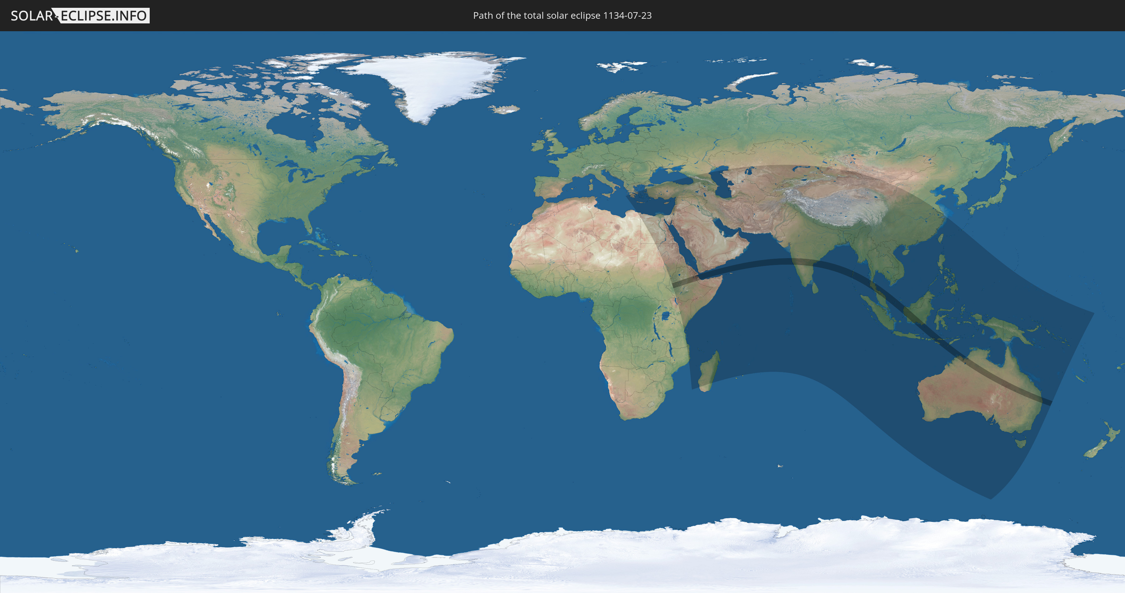
Die Sonnenfinsternis am 07/23/1134 kann man in 78 Ländern als partielle Sonnenfinsternis beobachten.
Der Finsternispfad verläuft durch 9 Länder. Nur in diesen Ländern ist sie als total Sonnenfinsternis zu sehen.
In den folgenden Ländern ist die Sonnenfinsternis total zu sehen
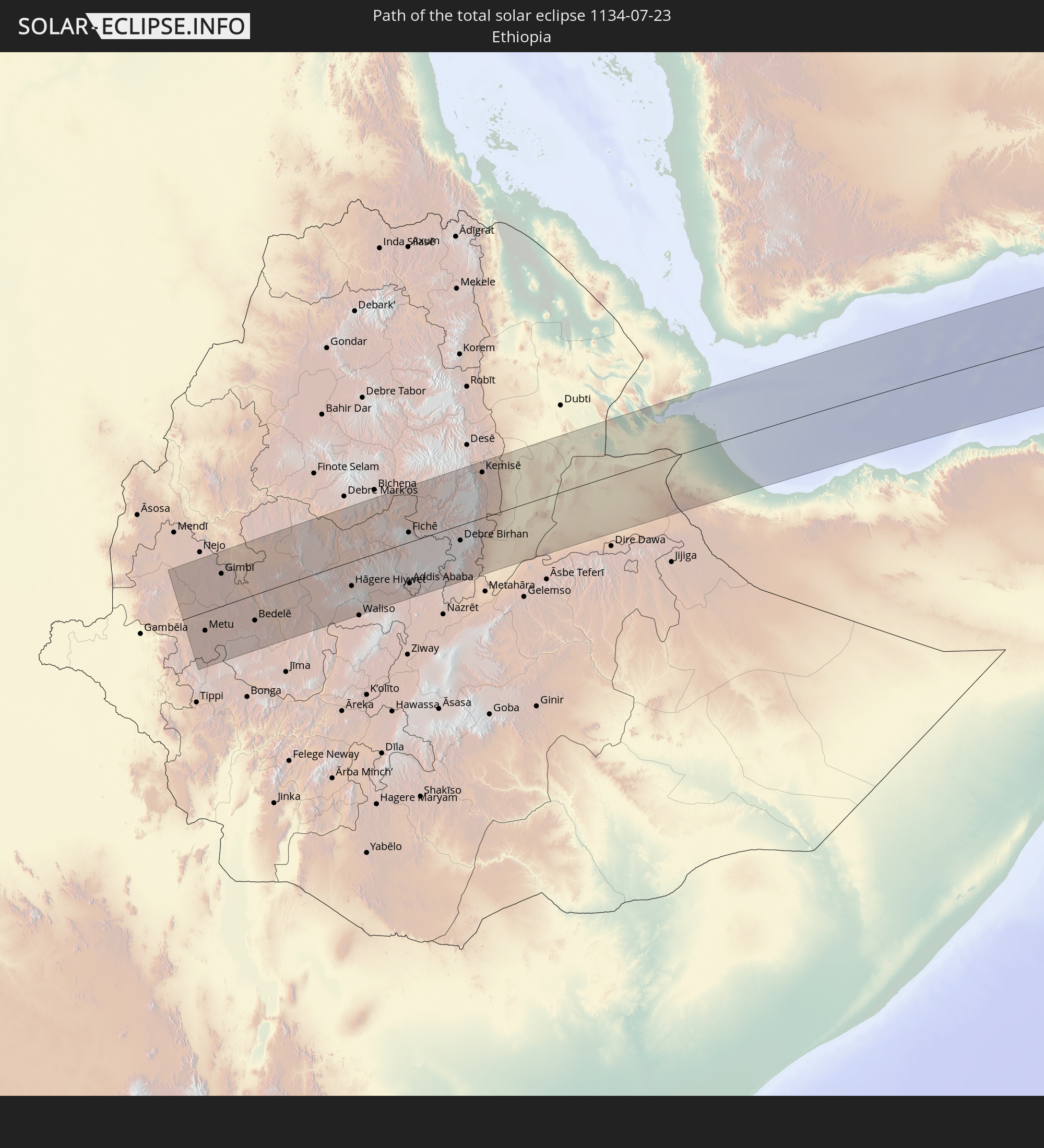 Ethiopia
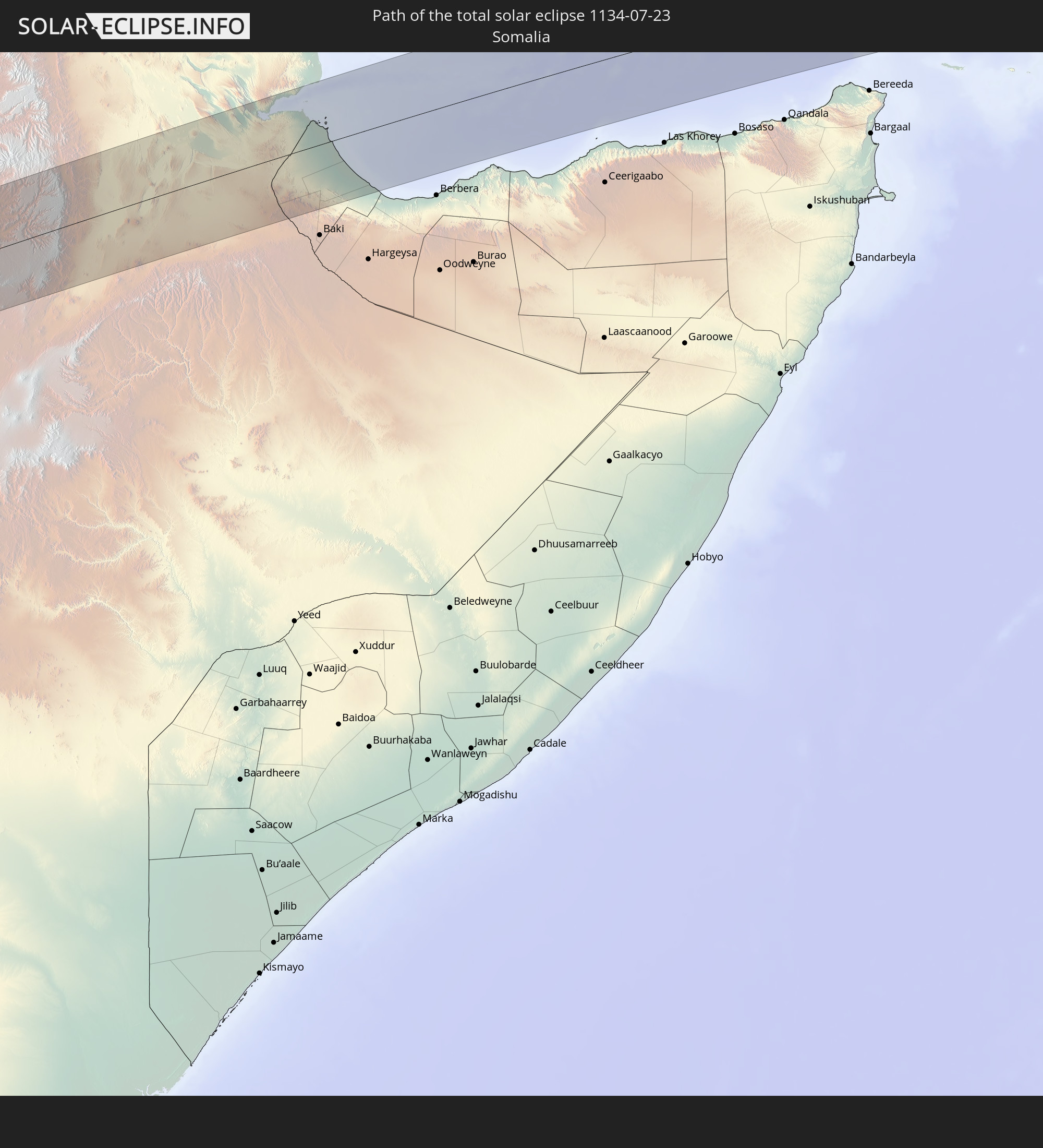 Somalia
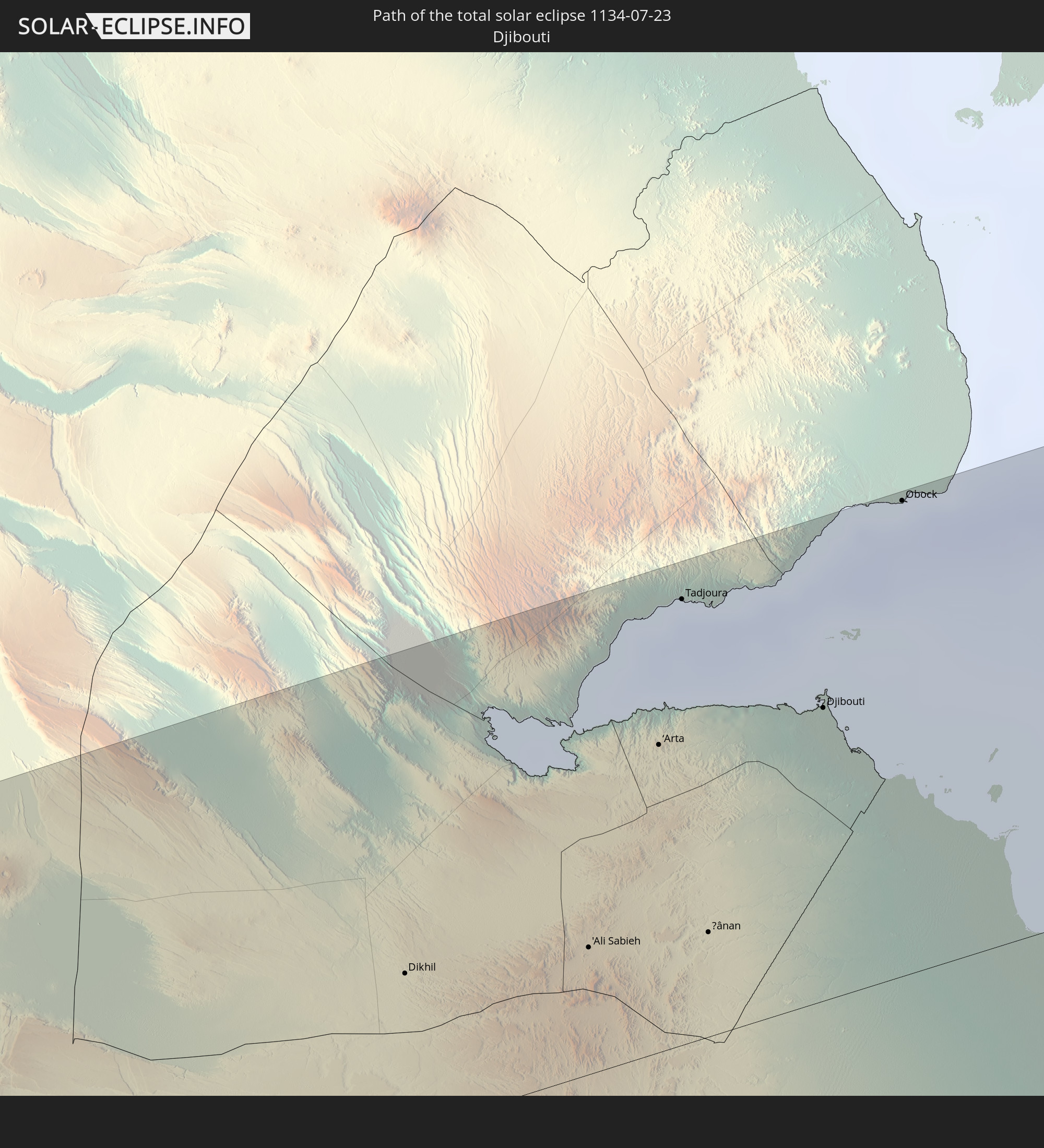 Djibouti
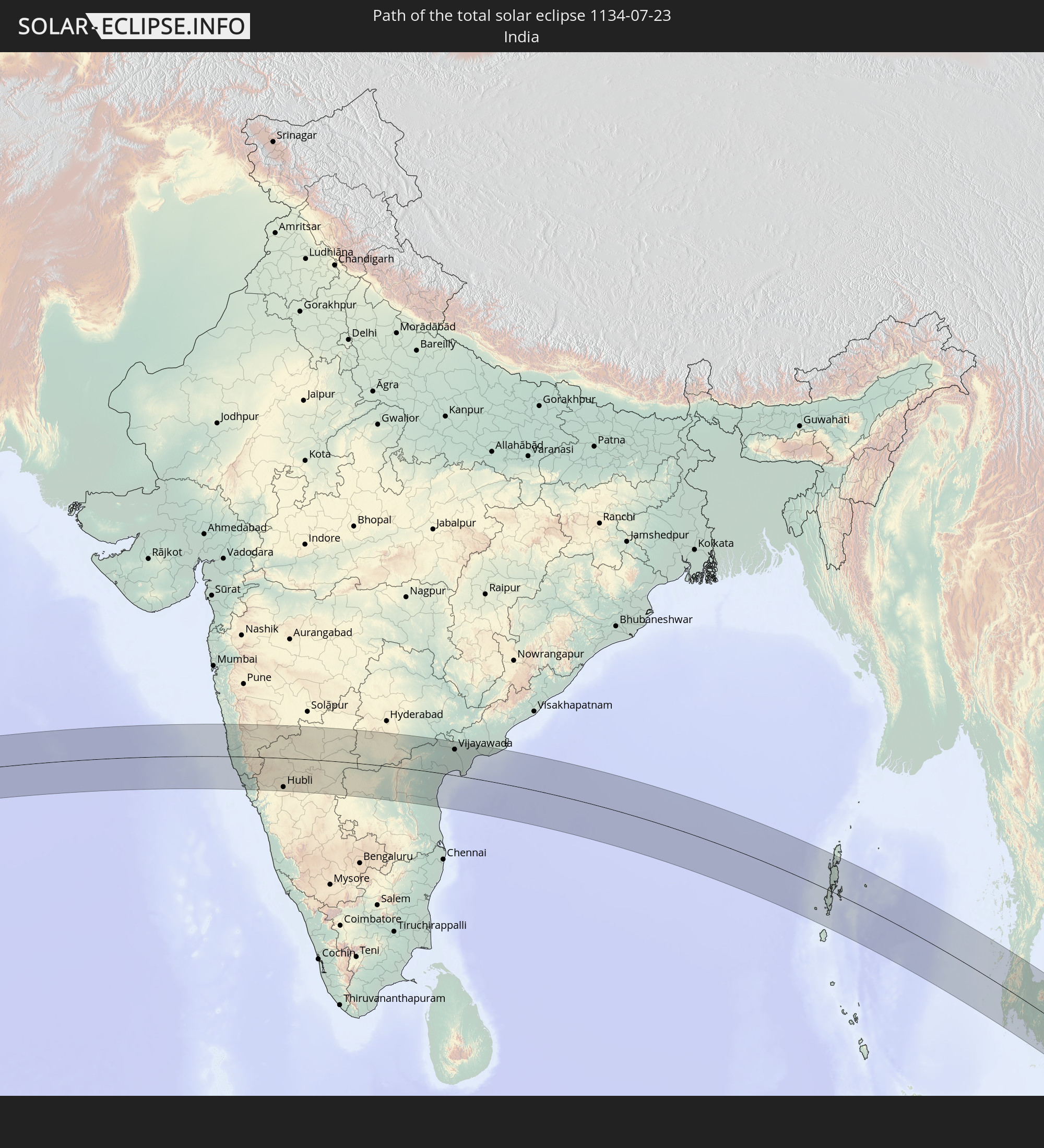 India
India
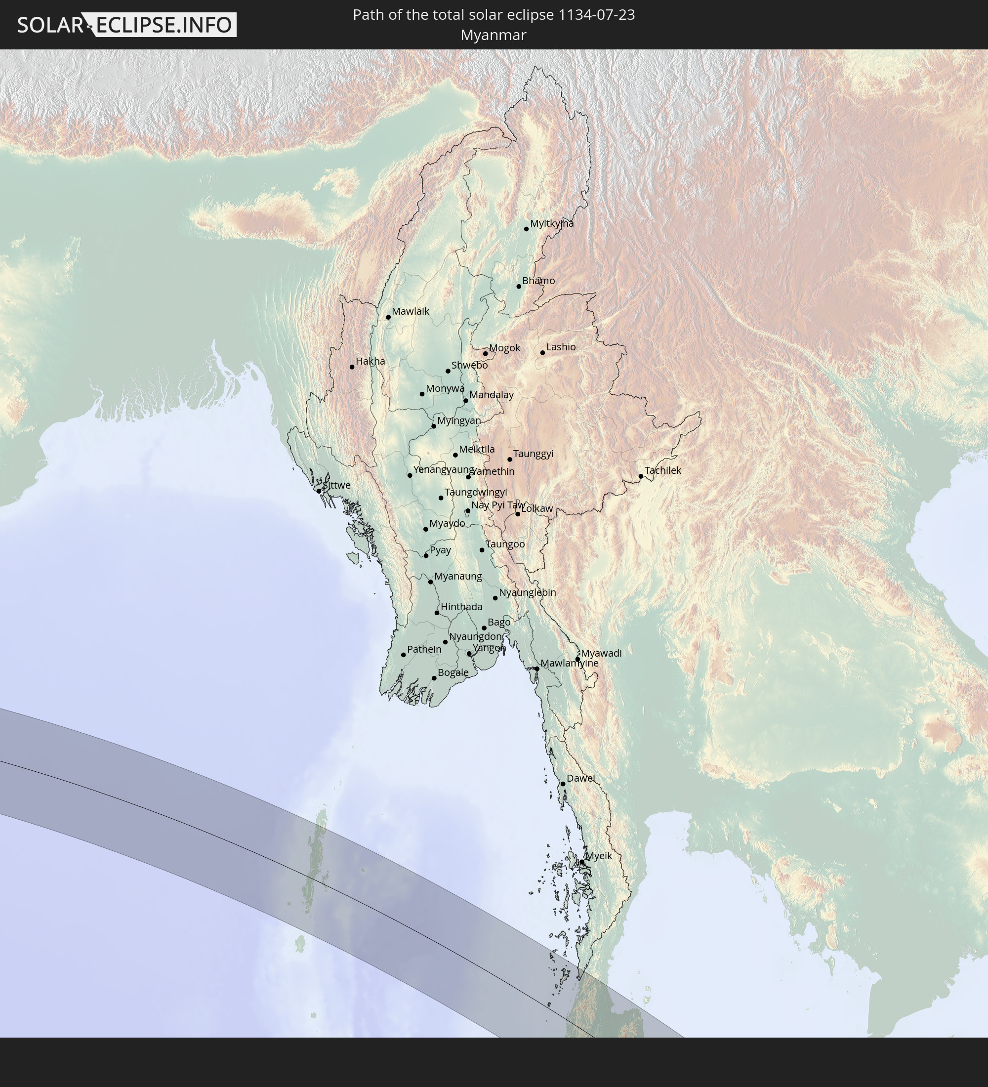 Myanmar
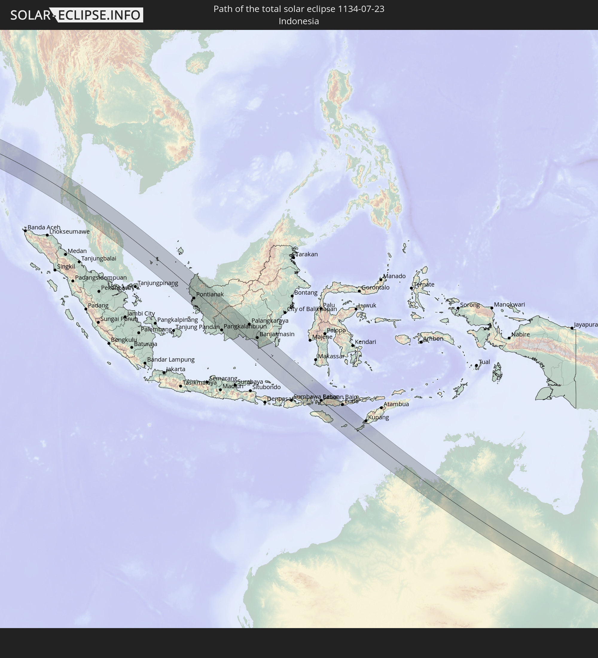 Indonesia
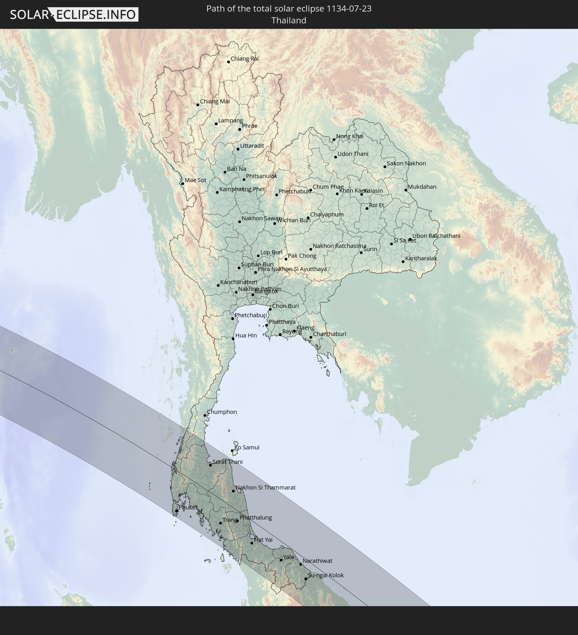 Thailand
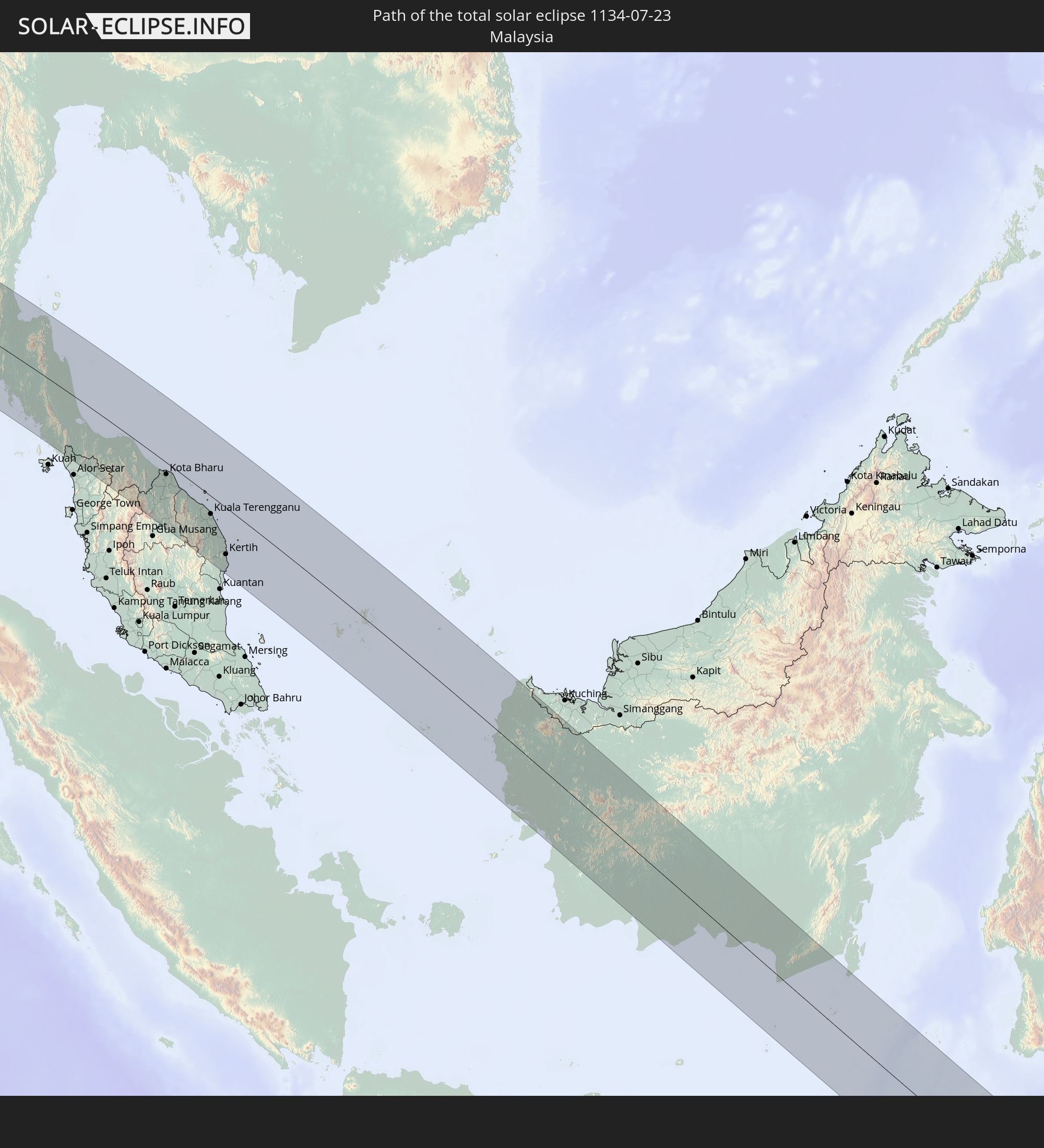 Malaysia
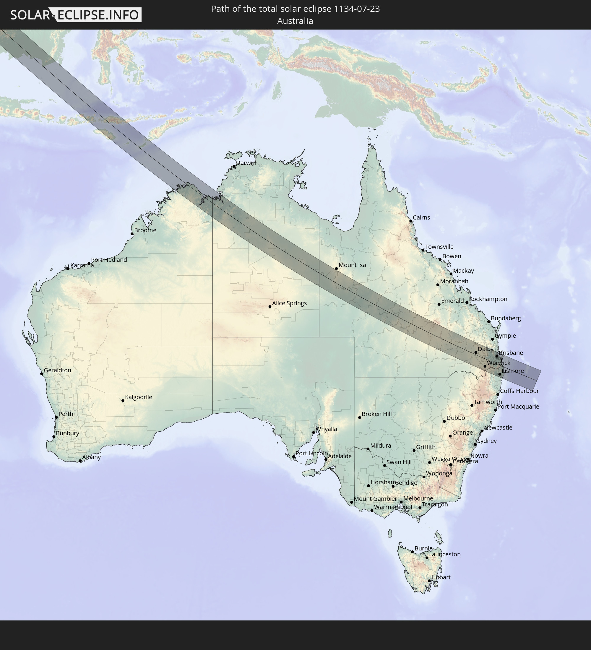 Australia
In den folgenden Ländern ist die Sonnenfinsternis partiell zu sehen
 Russia
 Kiribati
 Libya
Libya
 Greece
 Sudan
Sudan
 Egypt
Egypt
 Turkey
 Tanzania
 Mozambique
 Cyprus
 Ethiopia
 Kenya
Kenya
 State of Palestine
 Israel
 Saudi Arabia
 Jordan
 Lebanon
 Syria
Syria
 Eritrea
 Iraq
Iraq
 Georgia
 French Southern and Antarctic Lands
 Somalia
 Djibouti
 Yemen
Yemen
 Madagascar
 Comoros
 Armenia
 Iran
Iran
 Azerbaijan
 Mayotte
 Seychelles
 Kazakhstan
 Kuwait
 Bahrain
 Qatar
Qatar
 United Arab Emirates
 Oman
Oman
 Turkmenistan
 Uzbekistan
 Mauritius
 Afghanistan
 Pakistan
 Tajikistan
 India
India
 Kyrgyzstan
 British Indian Ocean Territory
 Maldives
 China
China
 Sri Lanka
 Nepal
Nepal
 Mongolia
 Bangladesh
 Bhutan
 Myanmar
 Indonesia
 Cocos Islands
 Thailand
 Malaysia
 Laos
Laos
 Vietnam
 Cambodia
 Singapore
 Christmas Island
 Australia
 Macau
Macau
 Hong Kong
 Brunei
 Taiwan
 Philippines
 Japan
Japan
 East Timor
 Palau
Palau
 Federated States of Micronesia
 Papua New Guinea
 Solomon Islands
 New Caledonia
 Nauru
Nauru
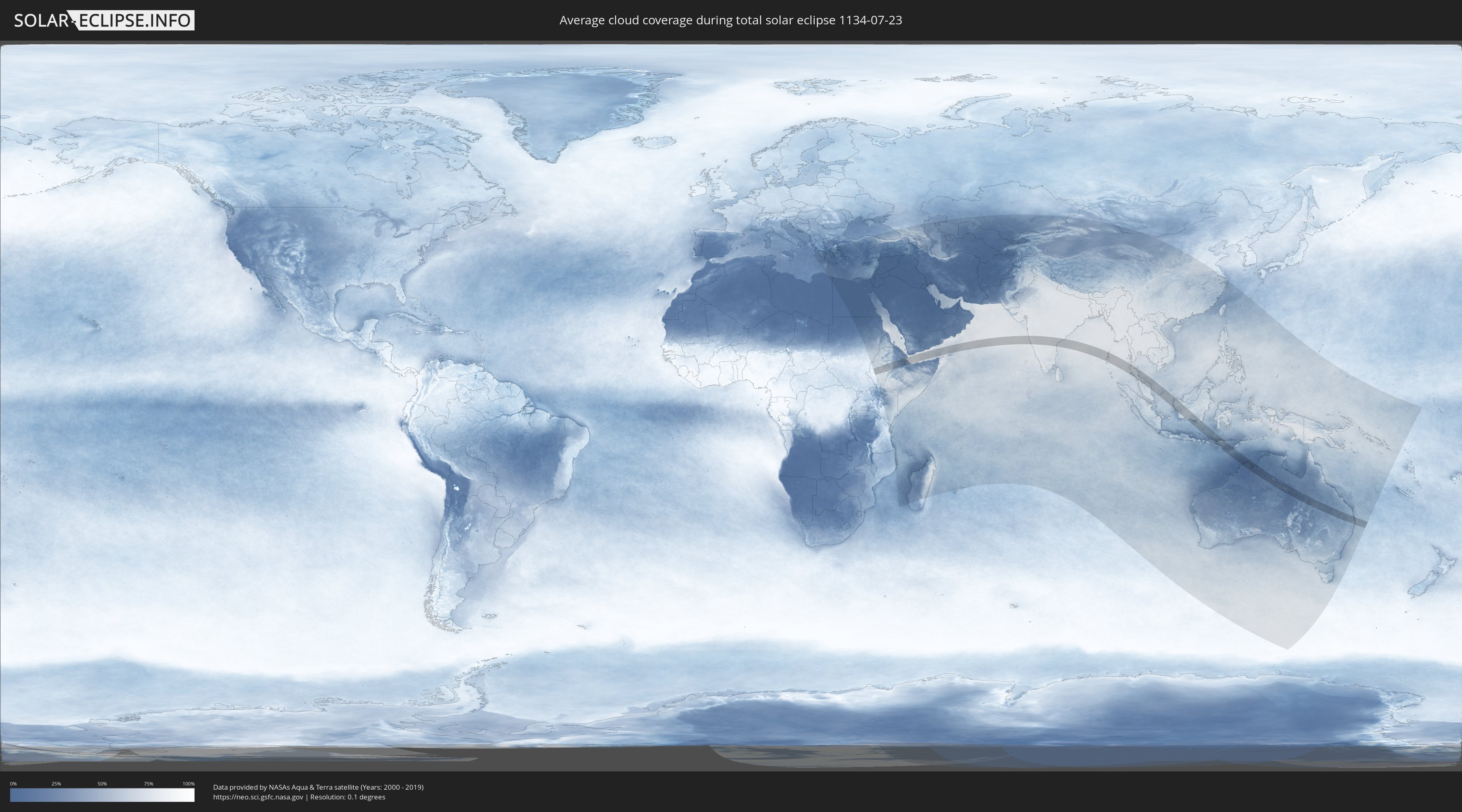
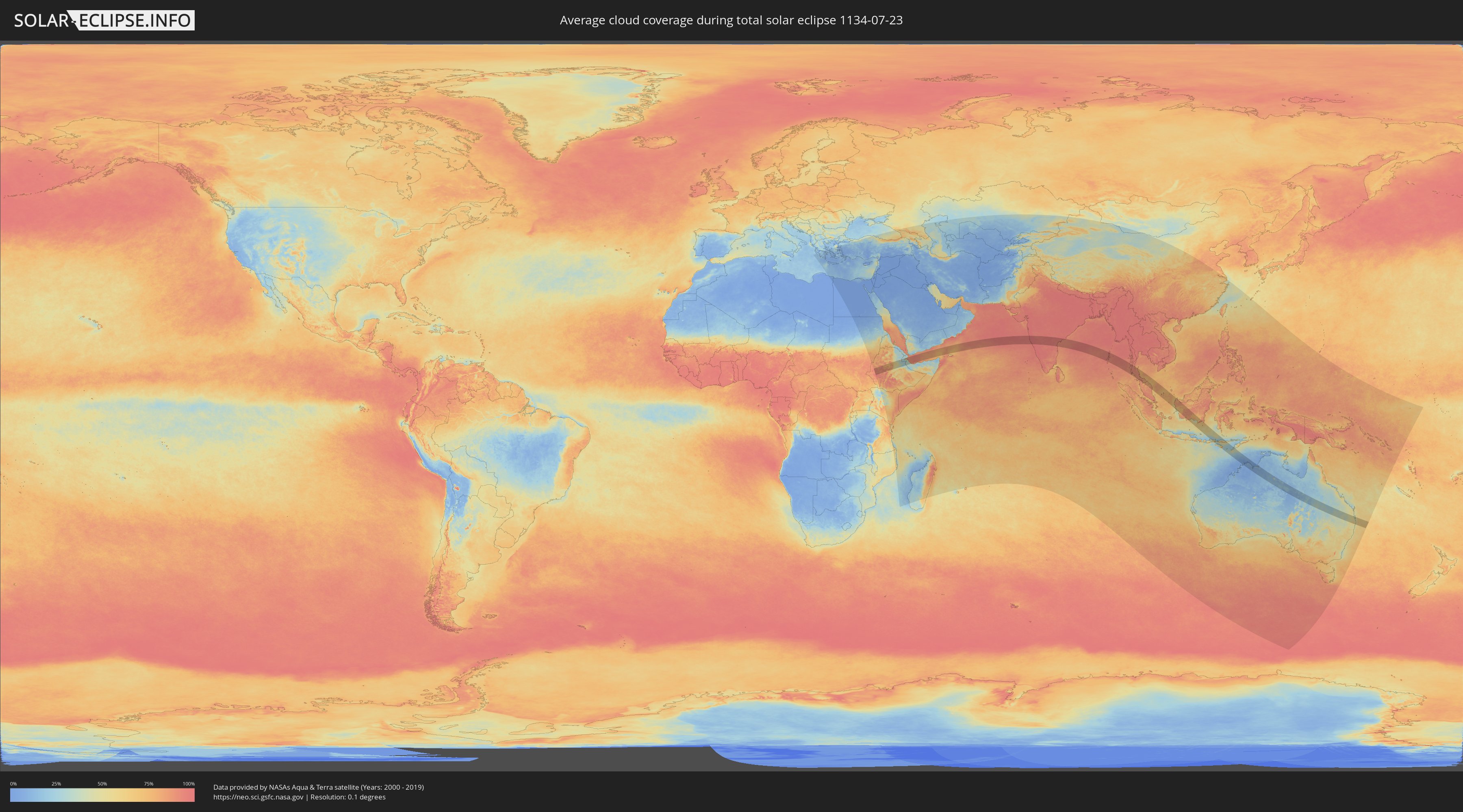
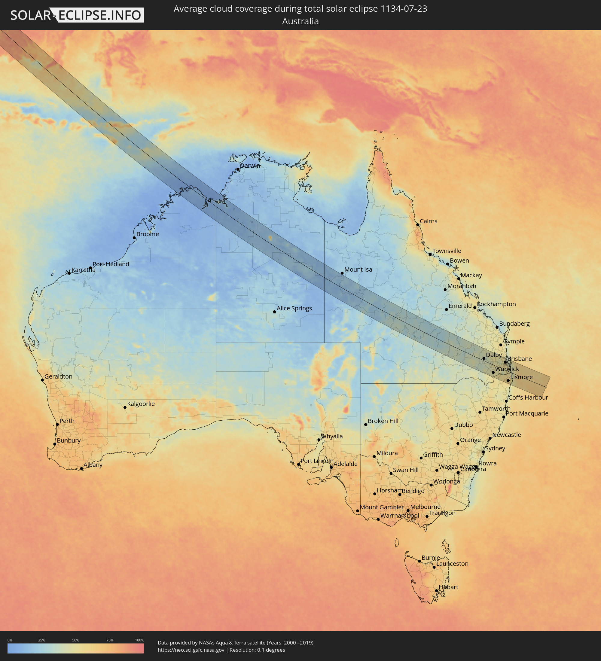
How will be the weather during the total solar eclipse on 07/23/1134?
Where is the best place to see the total solar eclipse of 07/23/1134?
The following maps show the average cloud coverage for the day of the total solar eclipse.
With the help of these maps, it is possible to find the place along the eclipse path, which has the best
chance of a cloudless sky.
Nevertheless, you should consider local circumstances and inform about the weather of your chosen
observation site.
The data is provided by NASAs satellites
AQUA and TERRA.
The cloud maps are averaged over a period of 19 years (2000 - 2019).
Detailed country maps
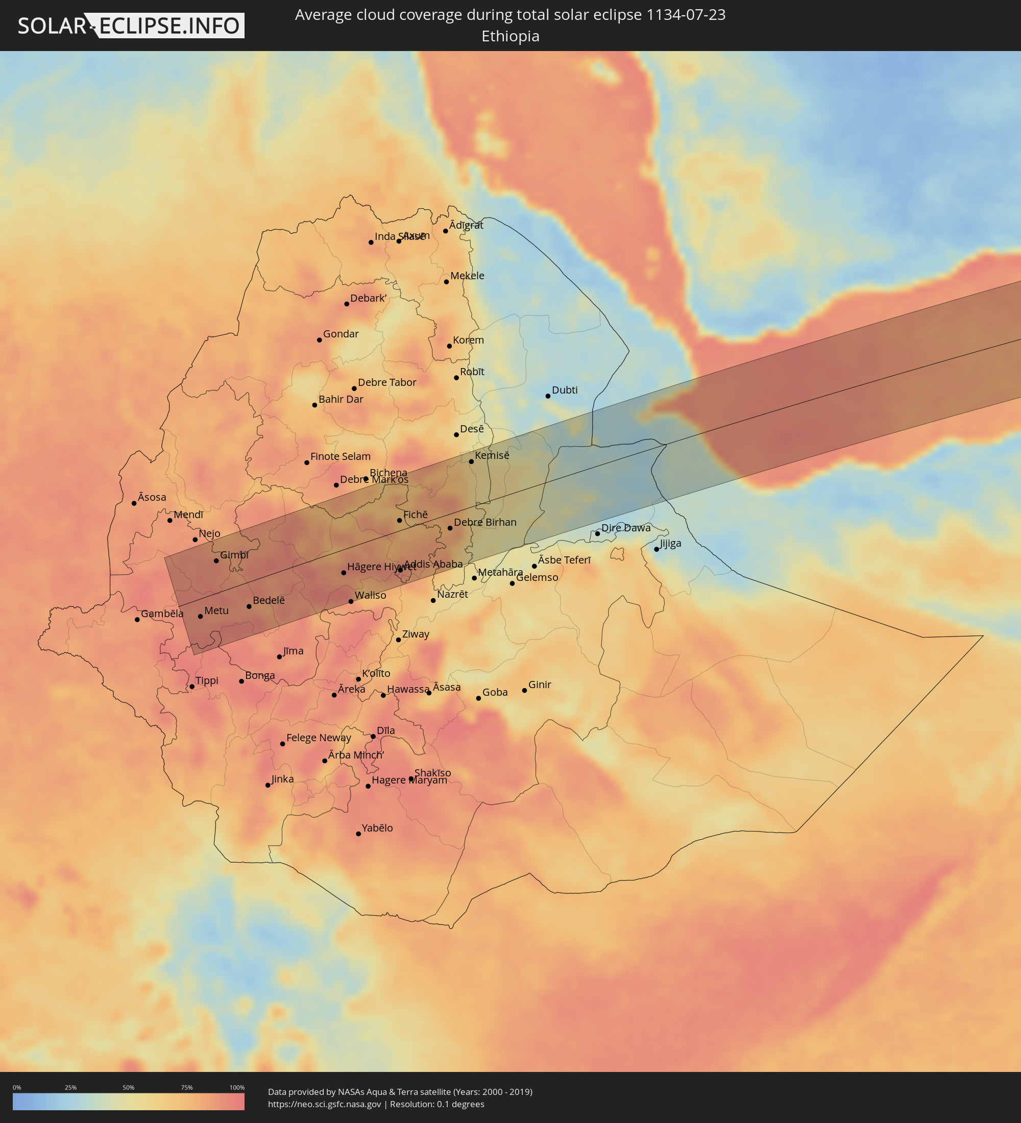 Ethiopia
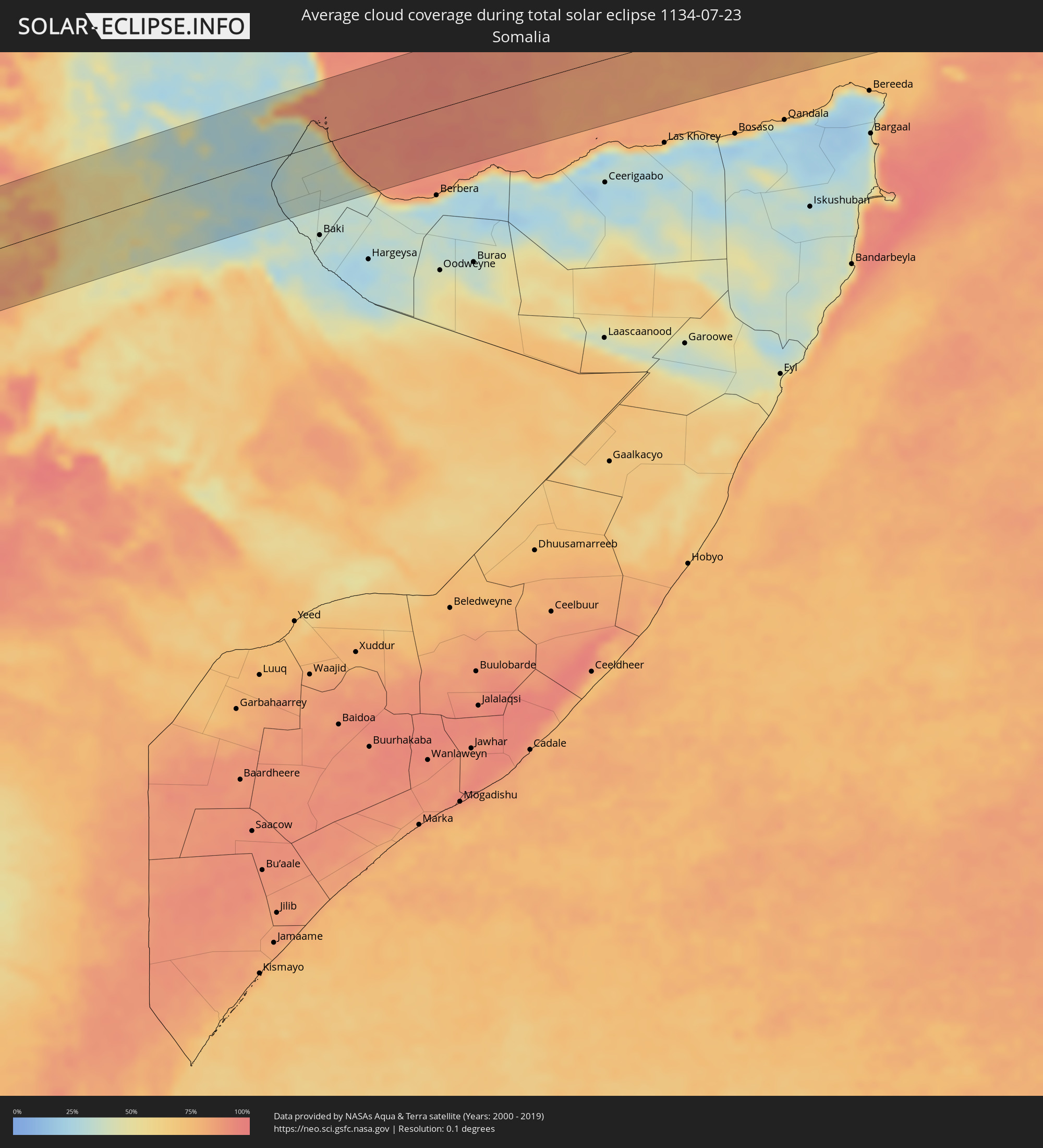 Somalia
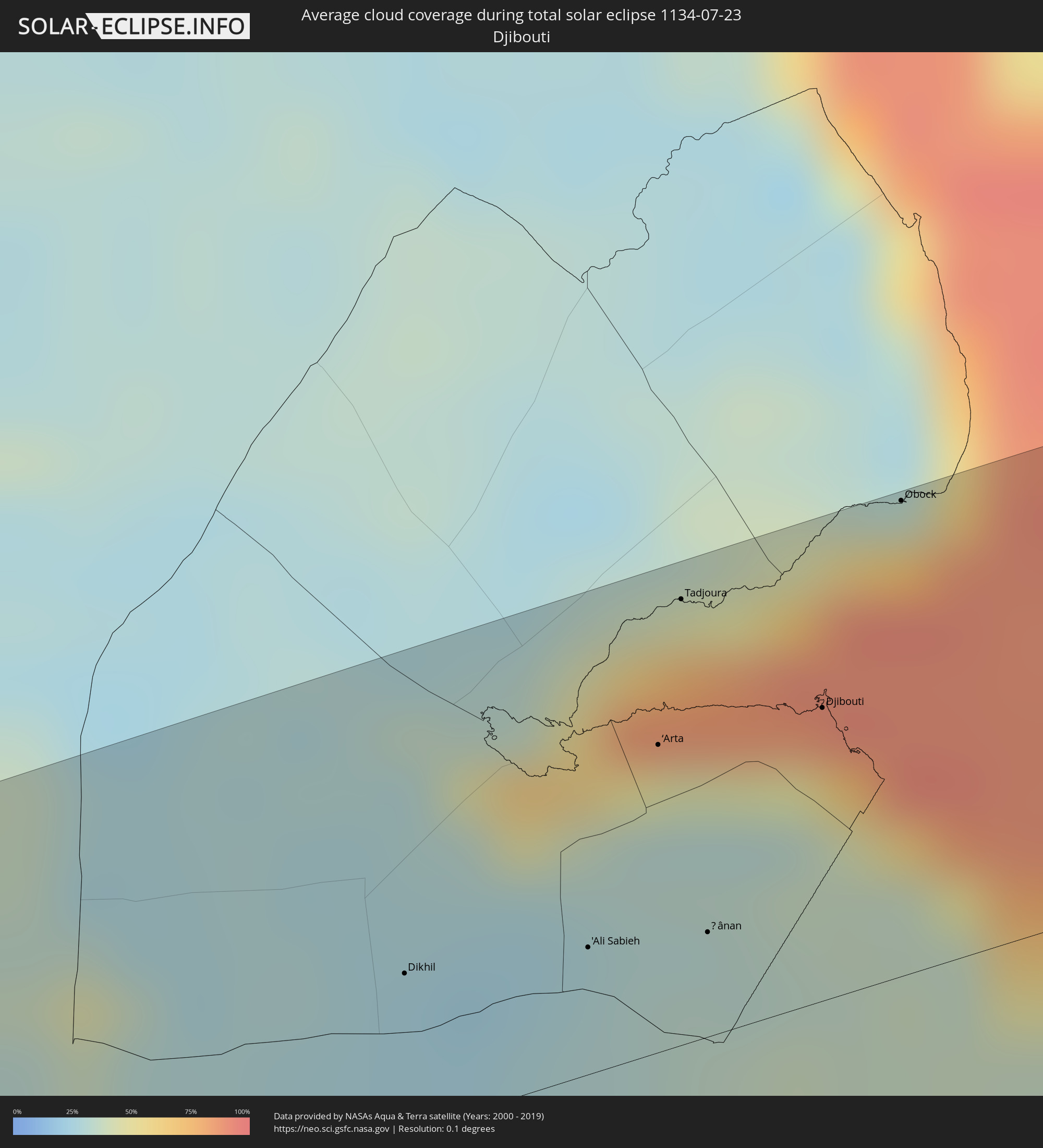 Djibouti
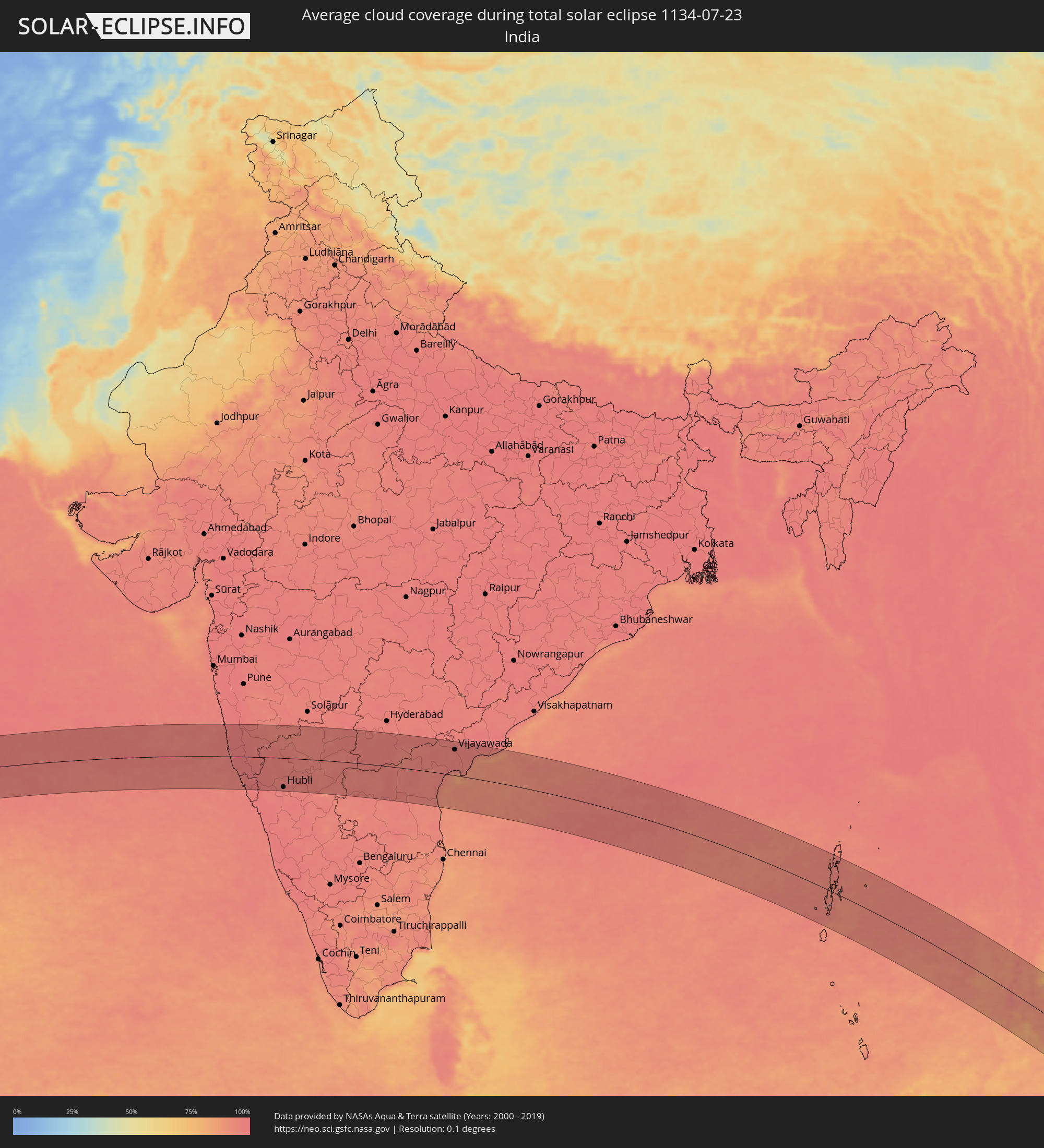 India
India
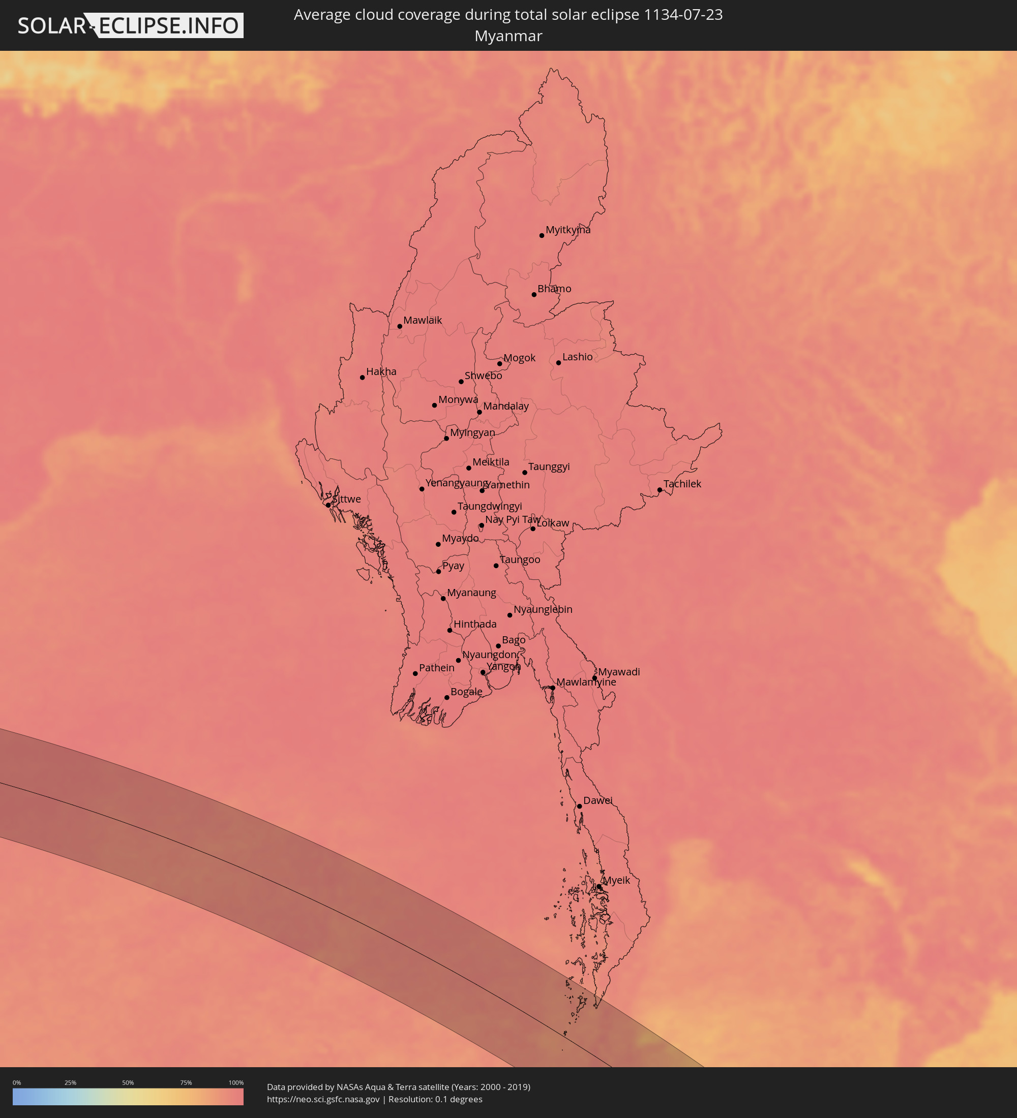 Myanmar
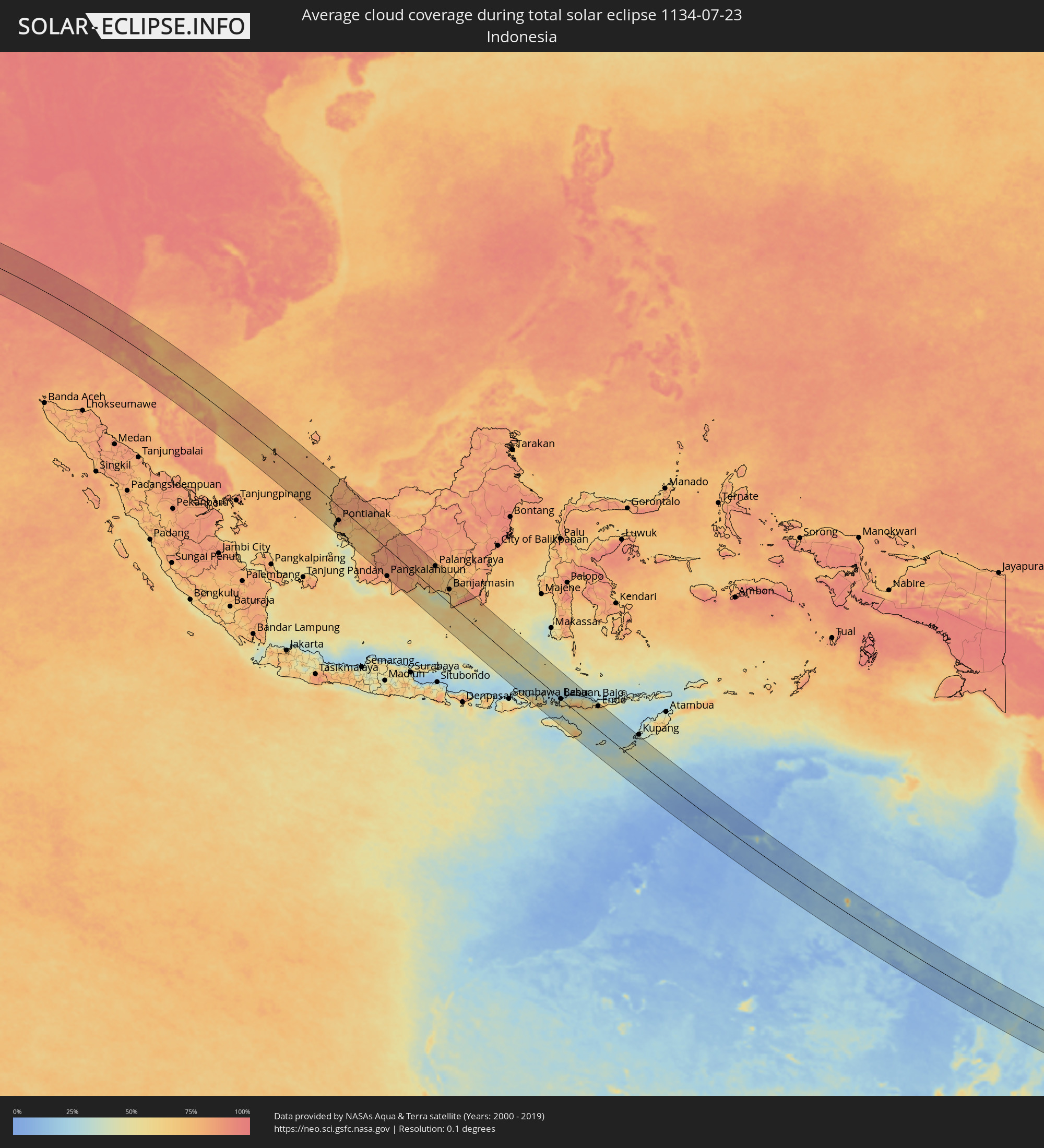 Indonesia
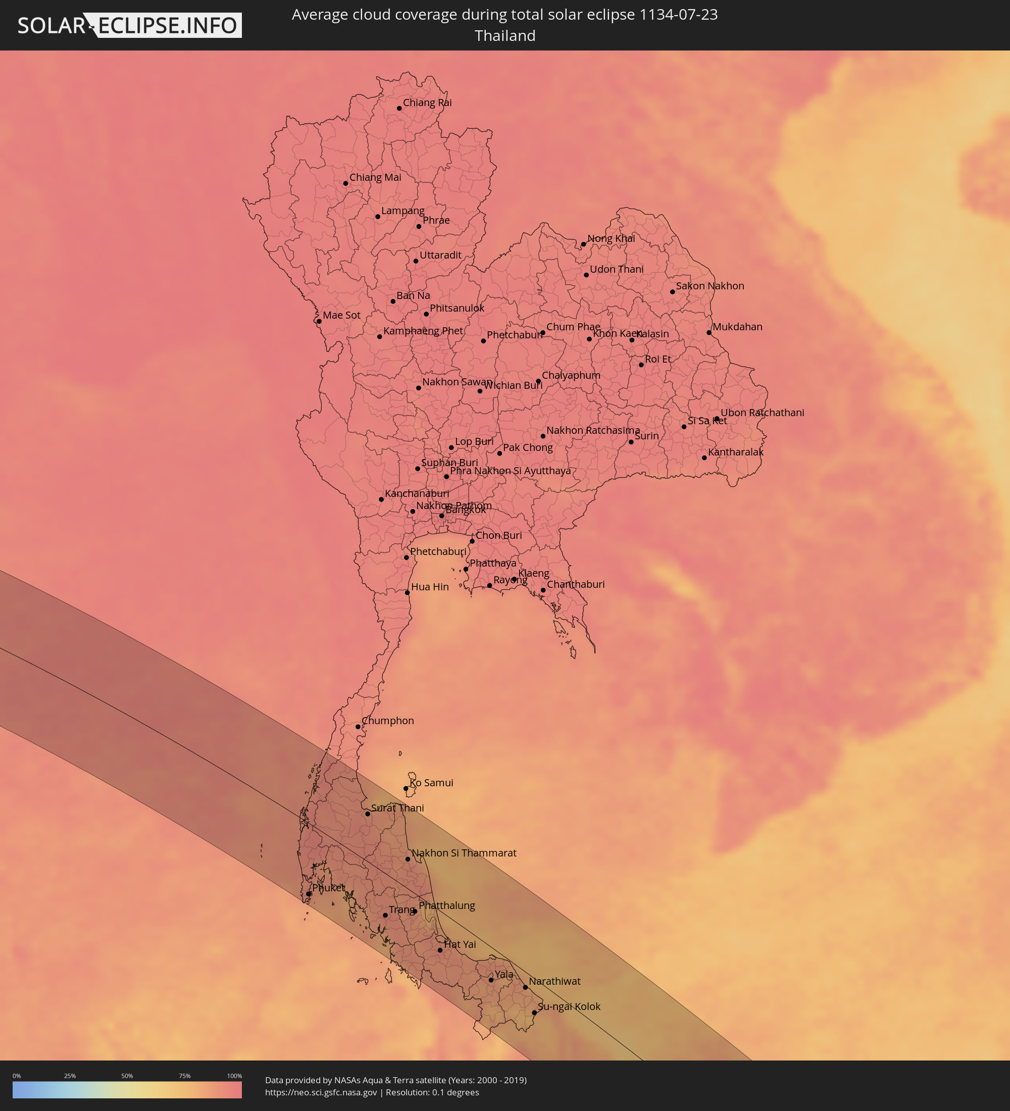 Thailand
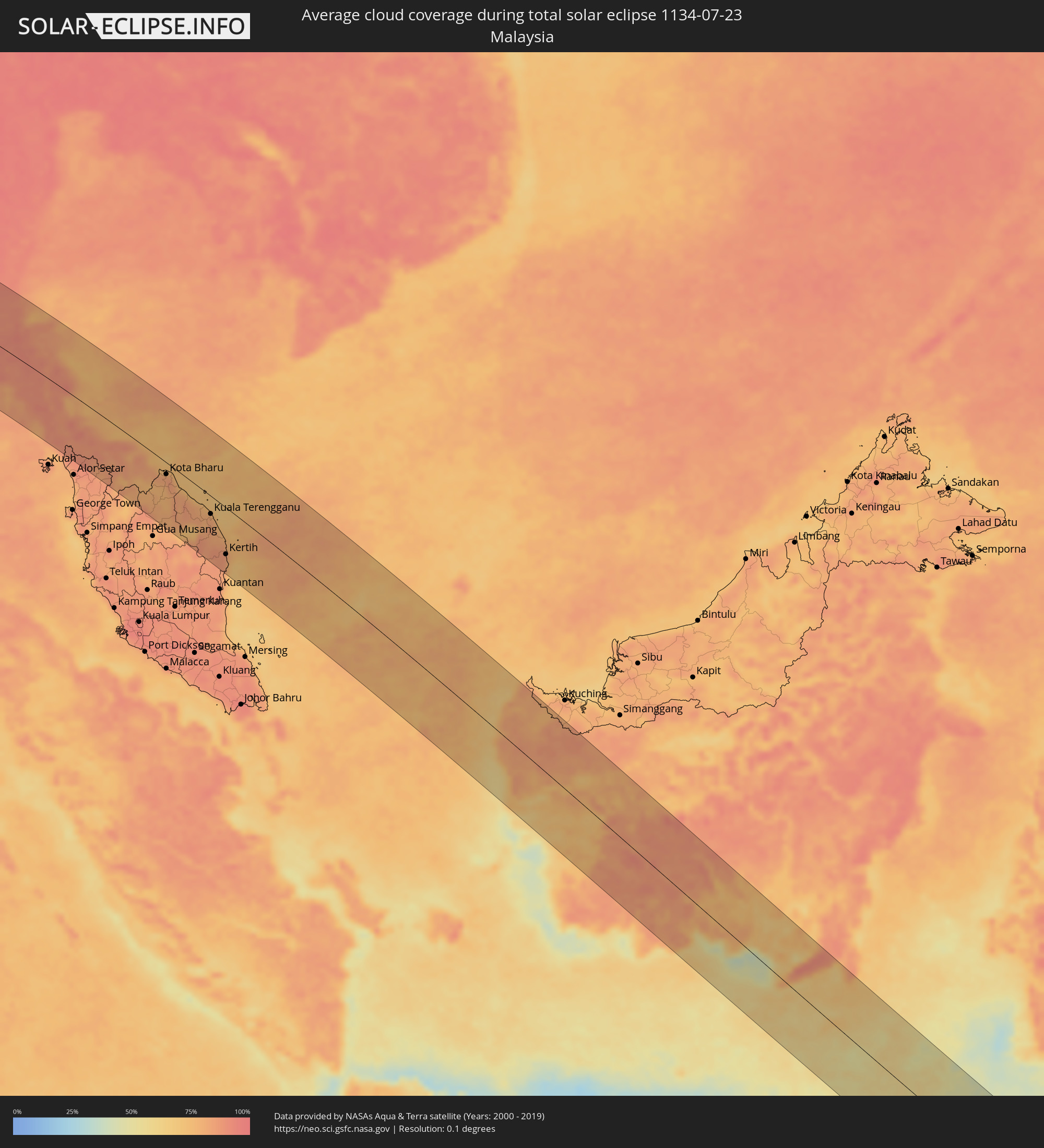 Malaysia
 Australia
Cities inside the path of the eclipse
The following table shows all locations with a population of more than 5,000 inside the eclipse path. Cities which have more than 100,000 inhabitants are marked bold. A click at the locations opens a detailed map.
| City | Type | Eclipse duration | Local time of max. eclipse | Distance to central line | Ø Cloud coverage |
|
Gorē, Oromiya
|
total | - | 05:59:30 UTC+02:27 | 44 km | 91% |
|
Metu, Oromiya
|
total | - | 05:59:30 UTC+02:27 | 30 km | 90% |
|
Gimbi, Oromiya
|
total | - | 05:59:27 UTC+02:27 | 52 km | 91% |
|
Bedelē, Oromiya
|
total | - | 05:59:31 UTC+02:27 | 42 km | 87% |
|
Shambu, Oromiya
|
total | - | 05:59:31 UTC+02:27 | 48 km | 87% |
|
Gēdo, Oromiya
|
total | - | 05:59:34 UTC+02:27 | 22 km | 89% |
|
Guder, Oromiya
|
total | - | 05:59:37 UTC+02:27 | 38 km | 84% |
|
Hāgere Hiywet, Oromiya
|
total | - | 05:59:37 UTC+02:27 | 40 km | 85% |
|
Dejen, Amhara
|
total | - | 05:59:35 UTC+02:27 | 75 km | 78% |
|
Tulu Bolo, Oromiya
|
total | - | 05:59:41 UTC+02:27 | 86 km | 75% |
|
Gebre Guracha, Oromiya
|
total | - | 05:59:38 UTC+02:27 | 27 km | 85% |
|
Ādīs ‘Alem, Oromiya
|
total | - | 05:59:41 UTC+02:27 | 54 km | 82% |
|
Genet, Oromiya
|
total | - | 05:59:42 UTC+02:27 | 54 km | 91% |
|
Sebeta, Oromiya
|
total | - | 05:59:43 UTC+02:27 | 74 km | 80% |
|
Fichē, Oromiya
|
total | - | 05:59:41 UTC+02:27 | 16 km | 75% |
|
Addis Ababa, Addis Ababa
|
total | - | 05:59:44 UTC+02:27 | 67 km | 85% |
|
Sendafa, Oromiya
|
total | - | 05:59:46 UTC+02:27 | 63 km | 88% |
|
Were Īlu, Amhara
|
total | - | 05:59:46 UTC+02:27 | 75 km | 75% |
|
Debre Birhan, Amhara
|
total | - | 05:59:49 UTC+02:27 | 25 km | 79% |
|
Debre Sīna, Amhara
|
total | - | 05:59:51 UTC+02:27 | 15 km | 67% |
|
Kemisē, Amhara
|
total | - | 05:59:50 UTC+02:27 | 73 km | 62% |
|
Abomsa, Amhara
|
total | - | 05:59:53 UTC+02:27 | 8 km | 57% |
|
Gewanē, Āfar
|
total | - | 06:00:01 UTC+02:27 | 12 km | 53% |
|
Dikhil, Dikhil
|
total | - | 06:00:24 UTC+02:27 | 31 km | 26% |
|
'Ali Sabieh, Ali Sabieh
|
total | - | 06:00:30 UTC+02:27 | 24 km | 28% |
|
‘Arta, Arta
|
total | - | 06:00:32 UTC+02:27 | 59 km | 34% |
|
Tadjoura, Tadjourah
|
total | - | 06:00:32 UTC+02:27 | 86 km | 77% |
|
Ḏânan, Ali Sabieh
|
total | - | 06:00:34 UTC+02:27 | 20 km | 33% |
|
Djibouti, Djibouti
|
total | - | 06:00:37 UTC+02:27 | 56 km | 49% |
|
Obock, Obock
|
total | - | 06:00:40 UTC+02:27 | 91 km | 72% |
|
Marmagao, Goa
|
total | - | 09:26:01 UTC+05:21 | 98 km | 95% |
|
Kolhāpur, Maharashtra
|
total | - | 09:26:19 UTC+05:21 | 46 km | 97% |
|
Ichalkaranji, Maharashtra
|
total | - | 09:26:45 UTC+05:21 | 47 km | 97% |
|
Belgaum, Karnataka
|
total | - | 09:27:11 UTC+05:21 | 47 km | 97% |
|
Sāngli, Maharashtra
|
total | - | 09:26:52 UTC+05:21 | 65 km | 97% |
|
Hubli, Karnataka
|
total | - | 09:28:37 UTC+05:21 | 100 km | 96% |
|
Gadag, Karnataka
|
total | - | 09:29:33 UTC+05:21 | 88 km | 95% |
|
Bagalkot, Karnataka
|
total | - | 09:29:19 UTC+05:21 | 3 km | 97% |
|
Bijapur, Karnataka
|
total | - | 09:29:04 UTC+05:21 | 68 km | 95% |
|
Hospet, Karnataka
|
total | - | 09:31:09 UTC+05:21 | 101 km | 91% |
|
Gangāwati, Karnataka
|
total | - | 09:31:21 UTC+05:21 | 82 km | 93% |
|
Bellary, Karnataka
|
total | - | 09:32:19 UTC+05:21 | 110 km | 94% |
|
Ādoni, Andhra Pradesh
|
total | - | 09:32:46 UTC+05:21 | 53 km | 94% |
|
Rāichūr, Karnataka
|
total | - | 09:32:37 UTC+05:21 | 12 km | 97% |
|
Guntakal Junction, Andhra Pradesh
|
total | - | 09:33:12 UTC+05:21 | 103 km | 96% |
|
Mahbūbnagar, Telangana
|
total | - | 09:33:37 UTC+05:21 | 78 km | 97% |
|
Nandyāl, Andhra Pradesh
|
total | - | 09:35:23 UTC+05:21 | 56 km | 97% |
|
Miriālgūda, Telangana
|
total | - | 09:36:49 UTC+05:21 | 111 km | 97% |
|
Kāvali, Andhra Pradesh
|
total | - | 09:39:02 UTC+05:21 | 98 km | 95% |
|
Ongole, Andhra Pradesh
|
total | - | 09:38:44 UTC+05:21 | 33 km | 95% |
|
Narasaraopet, Andhra Pradesh
|
total | - | 09:38:16 UTC+05:21 | 48 km | 96% |
|
Chilakalūrupet, Andhra Pradesh
|
total | - | 09:38:37 UTC+05:21 | 34 km | 95% |
|
Chīrāla, Andhra Pradesh
|
total | - | 09:39:12 UTC+05:21 | 8 km | 93% |
|
Guntur, Andhra Pradesh
|
total | - | 09:39:06 UTC+05:21 | 62 km | 96% |
|
Vijayawada, Andhra Pradesh
|
total | - | 09:39:23 UTC+05:21 | 88 km | 96% |
|
Gudivāda, Andhra Pradesh
|
total | - | 09:40:11 UTC+05:21 | 86 km | 97% |
|
Machilīpatnam, Andhra Pradesh
|
total | - | 09:40:41 UTC+05:21 | 61 km | 96% |
|
Bhīmavaram, Andhra Pradesh
|
total | - | 09:41:17 UTC+05:21 | 107 km | 93% |
|
Port Blair, Andaman and Nicobar Islands
|
total | - | 10:13:56 UTC+05:21 | 43 km | 95% |
|
Patong, Phuket
|
total | - | 11:54:54 UTC+06:42 | 110 km | 88% |
|
Rawai, Phuket
|
total | - | 11:55:10 UTC+06:42 | 119 km | 85% |
|
Ban Chalong, Phuket
|
total | - | 11:55:06 UTC+06:42 | 112 km | 85% |
|
Phuket, Phuket
|
total | - | 11:55:11 UTC+06:42 | 104 km | 90% |
|
Ranong, Ranong
|
total | - | 11:52:27 UTC+06:42 | 104 km | 90% |
|
Krabi, Krabi
|
total | - | 11:56:11 UTC+06:42 | 56 km | 85% |
|
Surat Thani, Surat Thani
|
total | - | 11:55:31 UTC+06:42 | 69 km | 90% |
|
Ban Na San, Surat Thani
|
total | - | 11:56:08 UTC+06:42 | 39 km | 90% |
|
Kantang, Trang
|
total | - | 11:58:48 UTC+06:42 | 81 km | 85% |
|
Trang, Trang
|
total | - | 11:58:47 UTC+06:42 | 61 km | 92% |
|
Huai Yot, Trang
|
total | - | 11:58:28 UTC+06:42 | 38 km | 89% |
|
Thung Song, Nakhon Si Thammarat
|
total | - | 11:57:58 UTC+06:42 | 0 km | 90% |
|
Ron Phibun, Nakhon Si Thammarat
|
total | - | 11:58:23 UTC+06:42 | 12 km | 90% |
|
Nakhon Si Thammarat, Nakhon Si Thammarat
|
total | - | 11:58:14 UTC+06:42 | 42 km | 91% |
|
Satun, Satun
|
total | - | 12:01:28 UTC+06:42 | 118 km | 82% |
|
Phatthalung, Phatthalung
|
total | - | 11:59:51 UTC+06:42 | 26 km | 88% |
|
Pak Phanang, Nakhon Si Thammarat
|
total | - | 11:58:57 UTC+06:42 | 49 km | 84% |
|
Ranot, Songkhla
|
total | - | 12:00:12 UTC+06:42 | 4 km | 80% |
|
Sadao, Songkhla
|
total | - | 12:02:20 UTC+06:42 | 93 km | 88% |
|
Hat Yai, Songkhla
|
total | - | 12:01:51 UTC+06:42 | 56 km | 90% |
|
Ban Mai, Songkhla
|
total | - | 12:01:42 UTC+06:42 | 34 km | 86% |
|
Pattani, Pattani
|
total | - | 12:04:00 UTC+06:42 | 20 km | 86% |
|
Yala, Yala
|
total | - | 12:04:37 UTC+06:42 | 47 km | 86% |
|
Sai Buri, Pattani
|
total | - | 12:05:10 UTC+06:42 | 11 km | 80% |
|
Ra-ngae, Narathiwat
|
total | - | 12:06:07 UTC+06:42 | 40 km | 82% |
|
Narathiwat, Narathiwat
|
total | - | 12:06:08 UTC+06:42 | 22 km | 83% |
|
Ban Su-ngai Pa Di, Narathiwat
|
total | - | 12:06:50 UTC+06:42 | 51 km | 78% |
|
Su-ngai Kolok, Narathiwat
|
total | - | 12:07:08 UTC+06:42 | 48 km | 77% |
|
Tak Bai, Narathiwat
|
total | - | 12:06:58 UTC+06:42 | 22 km | 76% |
|
Pasir Mas, Kelantan
|
total | - | 12:20:53 UTC+06:55 | 35 km | 78% |
|
Tanah Merah, Kelantan
|
total | - | 12:21:19 UTC+06:55 | 57 km | 77% |
|
Tumpat, Kelantan
|
total | - | 12:20:42 UTC+06:55 | 20 km | 82% |
|
Kampong Pangkal Kalong, Kelantan
|
total | - | 12:21:17 UTC+06:55 | 42 km | 77% |
|
Kota Bharu, Kelantan
|
total | - | 12:20:58 UTC+06:55 | 21 km | 82% |
|
Kampong Kadok, Kelantan
|
total | - | 12:21:13 UTC+06:55 | 32 km | 85% |
|
Peringat, Kelantan
|
total | - | 12:21:15 UTC+06:55 | 27 km | 85% |
|
Jertih, Terengganu
|
total | - | 12:22:15 UTC+06:55 | 40 km | 82% |
|
Kuala Terengganu, Terengganu
|
total | - | 12:24:29 UTC+06:55 | 32 km | 82% |
|
Marang, Terengganu
|
total | - | 12:24:51 UTC+06:55 | 39 km | 79% |
|
Cukai, Terengganu
|
total | - | 12:26:57 UTC+06:55 | 108 km | 84% |
|
Paka, Terengganu
|
total | - | 12:26:21 UTC+06:55 | 73 km | 86% |
|
Kertih, Terengganu
|
total | - | 12:26:35 UTC+06:55 | 83 km | 85% |
|
Sungai Raya, West Kalimantan
|
total | - | 12:56:47 UTC+07:07 | 25 km | 70% |
|
Pemangkat, West Kalimantan
|
total | - | 12:56:10 UTC+07:07 | 20 km | 77% |
|
Singkawang, West Kalimantan
|
total | - | 12:56:37 UTC+07:07 | 1 km | 80% |
|
Pontianak, West Kalimantan
|
total | - | 12:58:50 UTC+07:07 | 55 km | 83% |
|
Pangkalanbuun, Central Kalimantan
|
total | - | 13:07:28 UTC+07:07 | 109 km | 84% |
|
Sampit, Central Kalimantan
|
total | - | 13:09:41 UTC+07:07 | 1 km | 84% |
|
Palangkaraya, Central Kalimantan
|
total | - | 13:10:56 UTC+07:07 | 99 km | 80% |
|
Kualakapuas, Central Kalimantan
|
total | - | 13:12:57 UTC+07:07 | 66 km | 69% |
|
Banjarmasin, South Kalimantan
|
total | - | 14:04:09 UTC+07:57 | 55 km | 70% |
|
Martapura, South Kalimantan
|
total | - | 14:04:45 UTC+07:57 | 68 km | 67% |
|
Dompu, West Nusa Tenggara
|
total | - | 14:17:15 UTC+07:57 | 104 km | 63% |
|
Bima, West Nusa Tenggara
|
total | - | 14:17:32 UTC+07:57 | 79 km | 49% |
|
Labuan Bajo, East Nusa Tenggara
|
total | - | 14:19:14 UTC+07:57 | 1 km | 47% |
|
Waingapu, East Nusa Tenggara
|
total | - | 14:21:05 UTC+07:57 | 73 km | 54% |
|
Ruteng, East Nusa Tenggara
|
total | - | 14:20:10 UTC+07:57 | 31 km | 73% |
|
Ende, East Nusa Tenggara
|
total | - | 14:22:03 UTC+07:57 | 95 km | 66% |
|
Dalby, Queensland
|
total | - | 16:54:26 UTC+10:00 | 16 km | 39% |
|
Toowoomba, Queensland
|
total | - | 16:54:33 UTC+10:00 | 5 km | 47% |
|
Warwick, Queensland
|
total | - | 16:54:33 UTC+10:00 | 58 km | 48% |
|
Gatton, Queensland
|
total | - | 16:54:35 UTC+10:00 | 18 km | 51% |
|
Booval, Queensland
|
total | - | 16:54:39 UTC+10:00 | 33 km | 53% |
|
Samford Valley, Queensland
|
total | - | 16:54:40 UTC+10:00 | 61 km | 52% |
|
Springfield, Queensland
|
total | - | 16:54:40 UTC+10:00 | 34 km | 51% |
|
Morayfield, Queensland
|
total | - | 16:54:40 UTC+10:00 | 91 km | 50% |
|
Stafford Heights, Queensland
|
total | - | 16:54:41 UTC+10:00 | 64 km | 55% |
|
Stafford, Queensland
|
total | - | 16:54:41 UTC+10:00 | 63 km | 55% |
|
Chermside West, Queensland
|
total | - | 16:54:41 UTC+10:00 | 66 km | 55% |
|
Brisbane, Queensland
|
total | - | 16:54:41 UTC+10:00 | 57 km | 55% |
|
Windsor, Queensland
|
total | - | 16:54:41 UTC+10:00 | 61 km | 55% |
|
Bracken Ridge, Queensland
|
total | - | 16:54:41 UTC+10:00 | 73 km | 53% |
|
Casino, New South Wales
|
total | - | 16:54:39 UTC+10:00 | 84 km | 54% |
|
Margate, Queensland
|
total | - | 16:54:41 UTC+10:00 | 83 km | 41% |
|
Scarborough, Queensland
|
total | - | 16:54:41 UTC+10:00 | 88 km | 41% |
|
Logan City, Queensland
|
total | - | 16:54:41 UTC+10:00 | 43 km | 55% |
|
Waterford West, Queensland
|
total | - | 16:54:42 UTC+10:00 | 39 km | 53% |
|
Tamborine Mountain, Queensland
|
total | - | 16:54:42 UTC+10:00 | 13 km | 49% |
|
Cleveland, Queensland
|
total | - | 16:54:42 UTC+10:00 | 61 km | 43% |
|
Lismore, New South Wales
|
total | - | 16:54:40 UTC+10:00 | 70 km | 60% |
|
Upper Coomera, Queensland
|
total | - | 16:54:42 UTC+10:00 | 24 km | 49% |
|
Oxenford, Queensland
|
total | - | 16:54:43 UTC+10:00 | 25 km | 49% |
|
Murwillumbah, New South Wales
|
total | - | 16:54:42 UTC+10:00 | 16 km | 54% |
|
Gold Coast, Queensland
|
total | - | 16:54:43 UTC+10:00 | 19 km | 45% |
|
Banora Point, New South Wales
|
total | - | 16:54:43 UTC+10:00 | 1 km | 47% |
|
Ballina, New South Wales
|
total | - | 16:54:42 UTC+10:00 | 64 km | 46% |
|
Byron Bay, New South Wales
|
total | - | 16:54:43 UTC+10:00 | 40 km | 49% |