Total solar eclipse of 07/05/1274
| Day of week: | Thursday |
| Maximum duration of eclipse: | 06m35s |
| Maximum width of eclipse path: | 278 km |
| Saros cycle: | 105 |
| Coverage: | 100% |
| Magnitude: | 1.07 |
| Gamma: | -0.5742 |
Wo kann man die Sonnenfinsternis vom 07/05/1274 sehen?
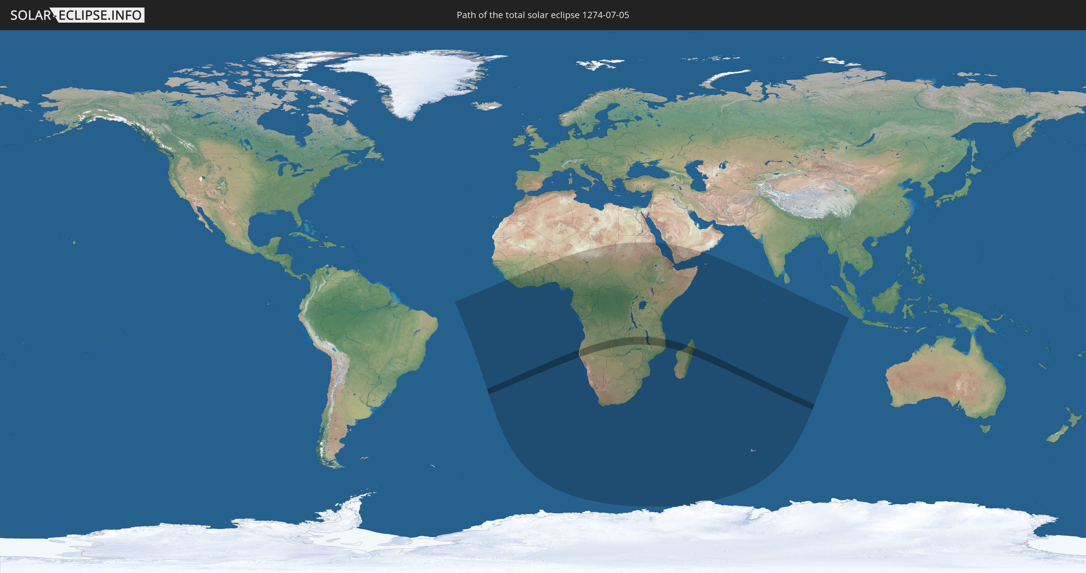
Die Sonnenfinsternis am 07/05/1274 kann man in 54 Ländern als partielle Sonnenfinsternis beobachten.
Der Finsternispfad verläuft durch 8 Länder. Nur in diesen Ländern ist sie als total Sonnenfinsternis zu sehen.
In den folgenden Ländern ist die Sonnenfinsternis total zu sehen
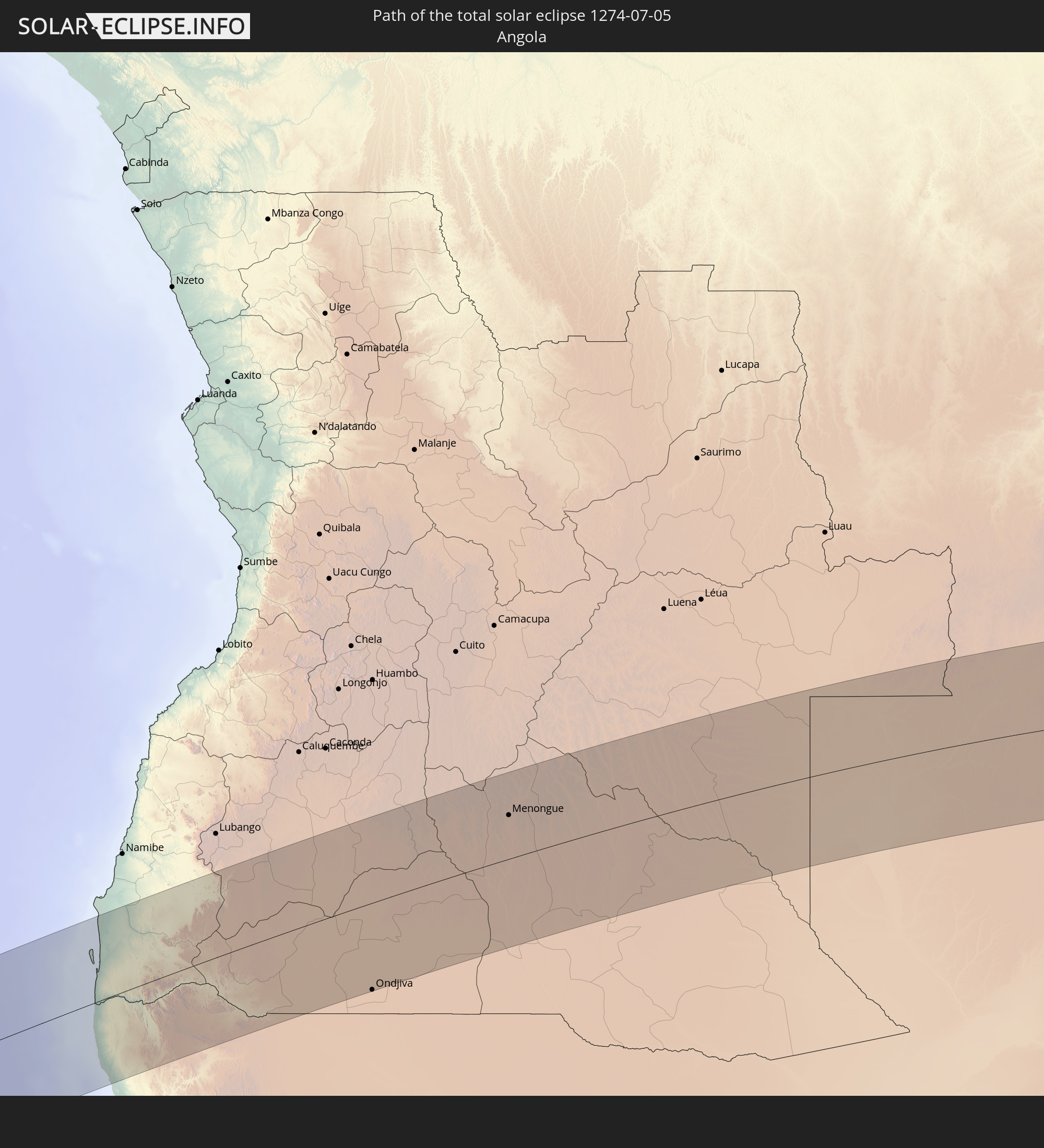 Angola
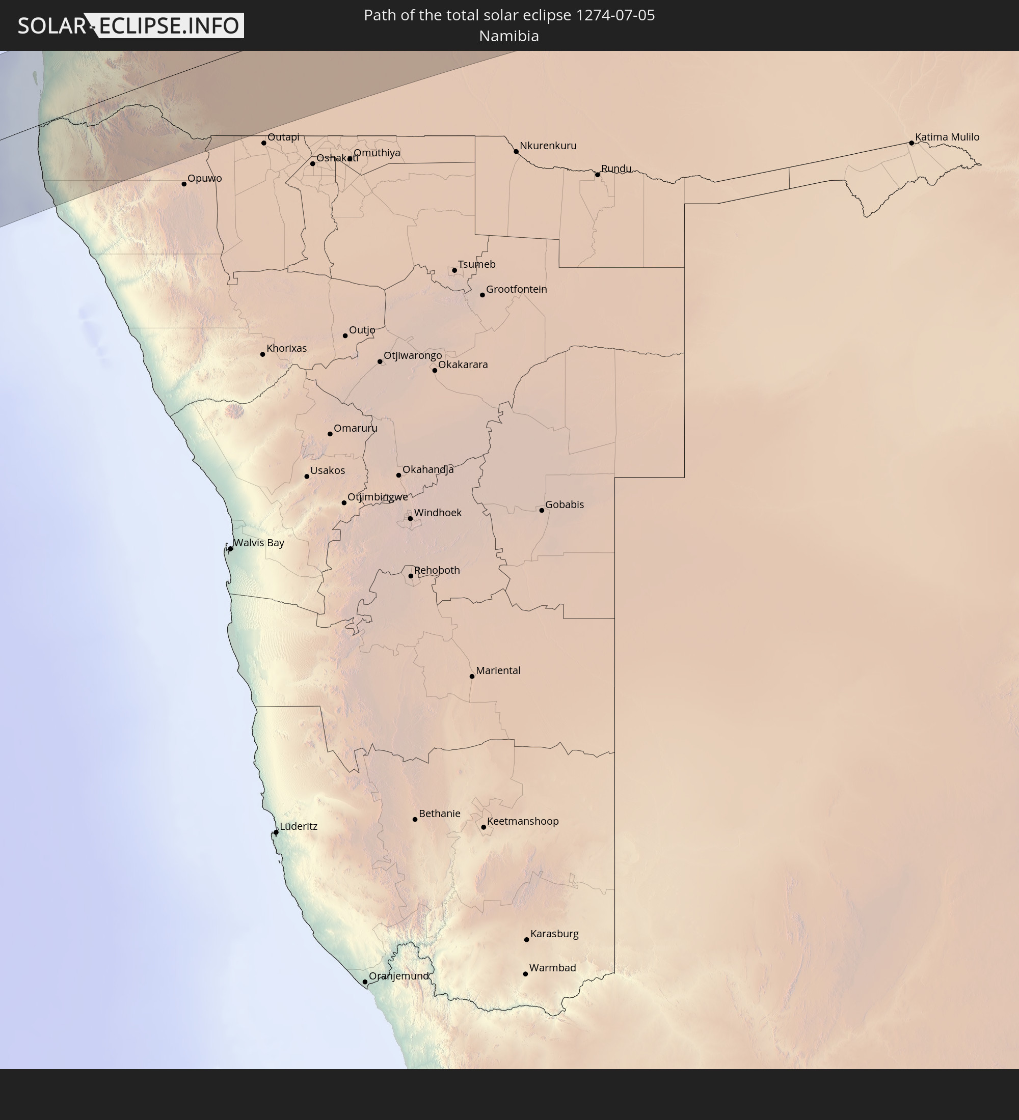 Namibia
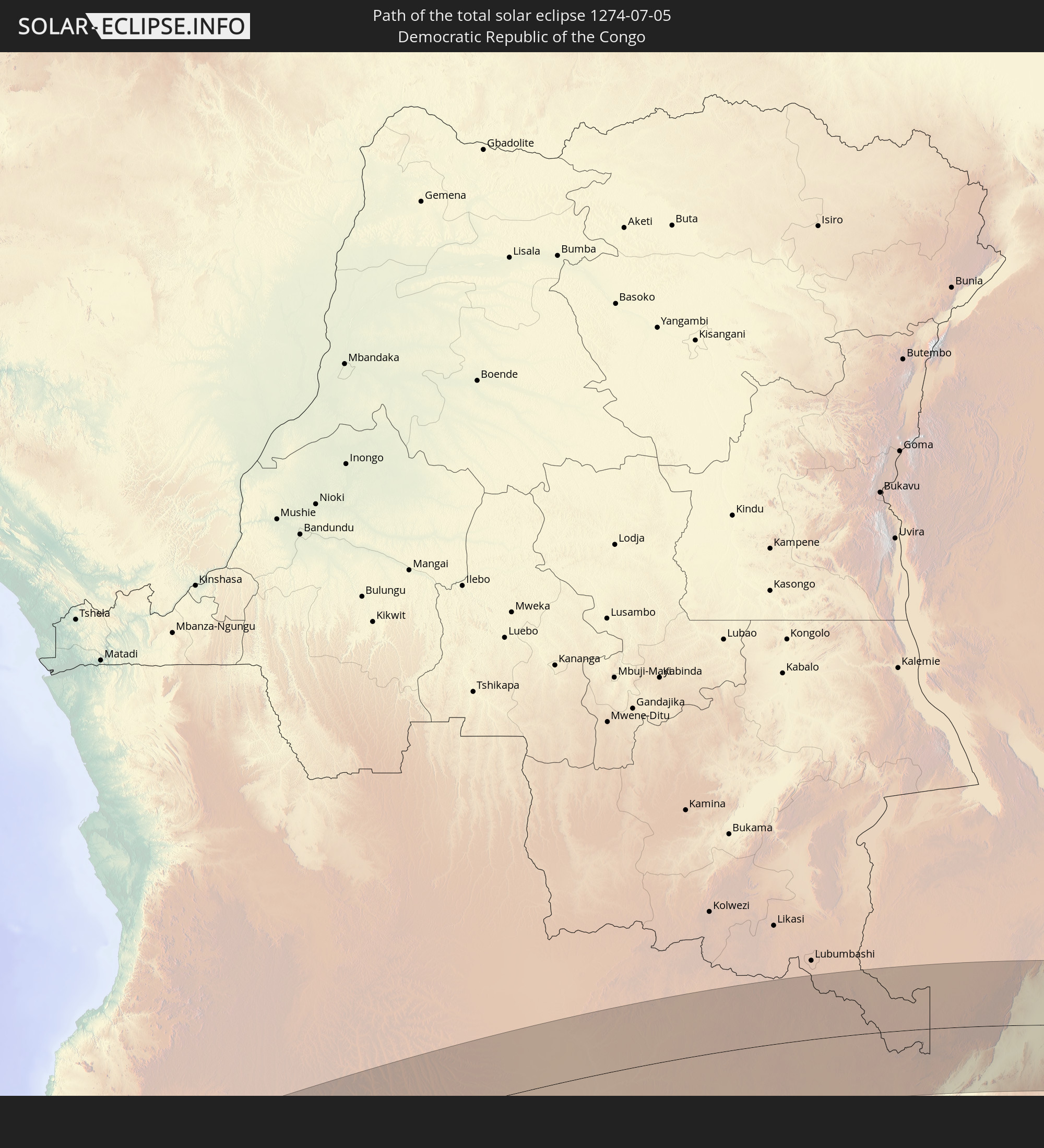 Democratic Republic of the Congo
 Zambia
 Mozambique
 Malawi
 Madagascar
 Mauritius
In den folgenden Ländern ist die Sonnenfinsternis partiell zu sehen
 Antarctica
 Guinea
 Saint Helena, Ascension and Tristan da Cunha
 Sierra Leone
 Liberia
 Ivory Coast
 Burkina Faso
 Ghana
Ghana
 Togo
Togo
 Niger
Niger
 Benin
Benin
 Nigeria
 Bouvet Island
 Equatorial Guinea
 São Tomé and Príncipe
 Cameroon
 Gabon
Gabon
 Republic of the Congo
 Angola
 Namibia
 Democratic Republic of the Congo
 Chad
Chad
 Central African Republic
 South Africa
 Botswana
 Sudan
Sudan
 Zambia
 Zimbabwe
 Lesotho
 Rwanda
 Burundi
 Tanzania
 Uganda
 Mozambique
 Swaziland
 Malawi
 Ethiopia
 Kenya
Kenya
 Saudi Arabia
 Eritrea
 French Southern and Antarctic Lands
 Somalia
 Djibouti
 Yemen
Yemen
 Madagascar
 Comoros
 Mayotte
 Seychelles
 Réunion
 Mauritius
 British Indian Ocean Territory
 Heard Island and McDonald Islands
 Maldives
 Cocos Islands
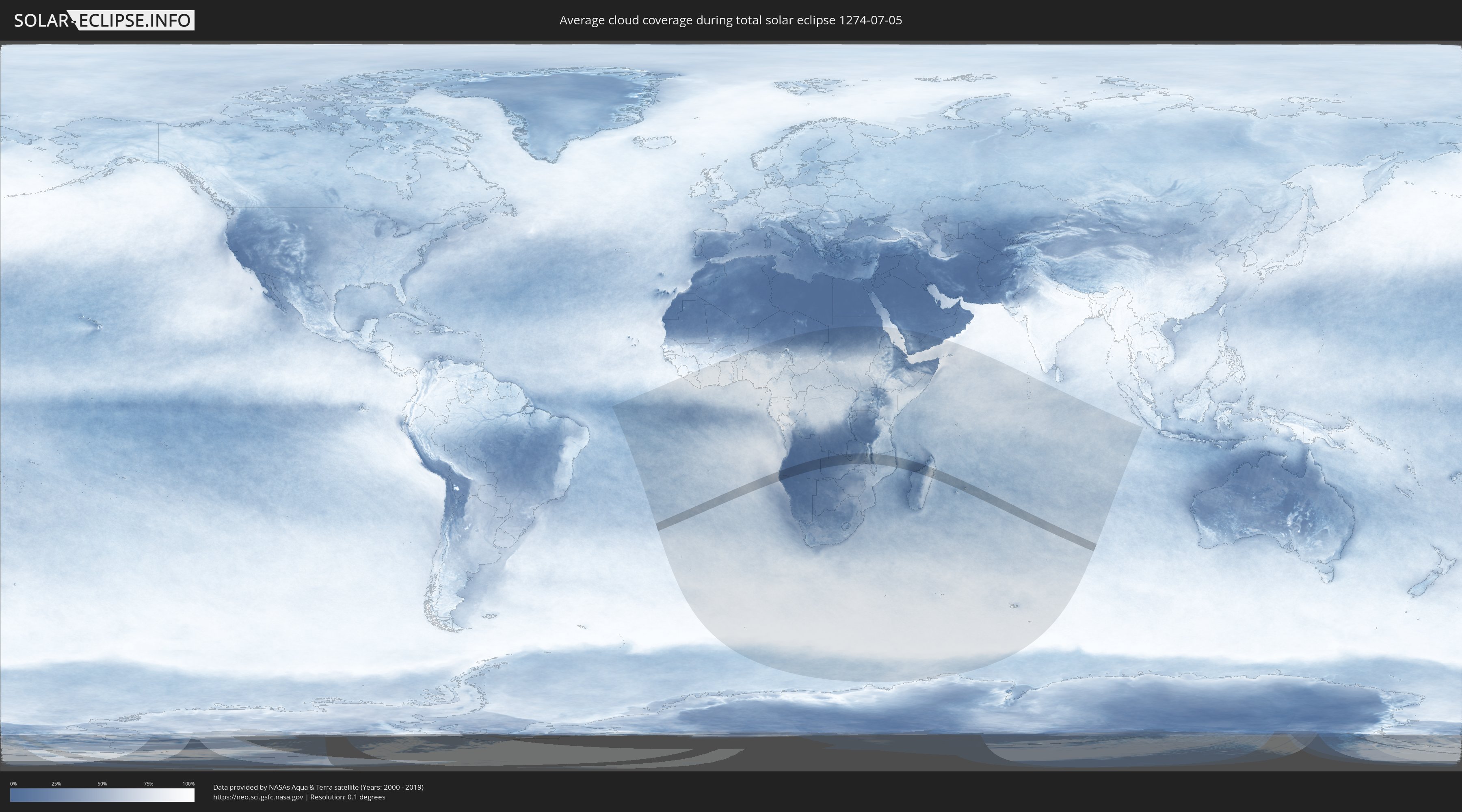
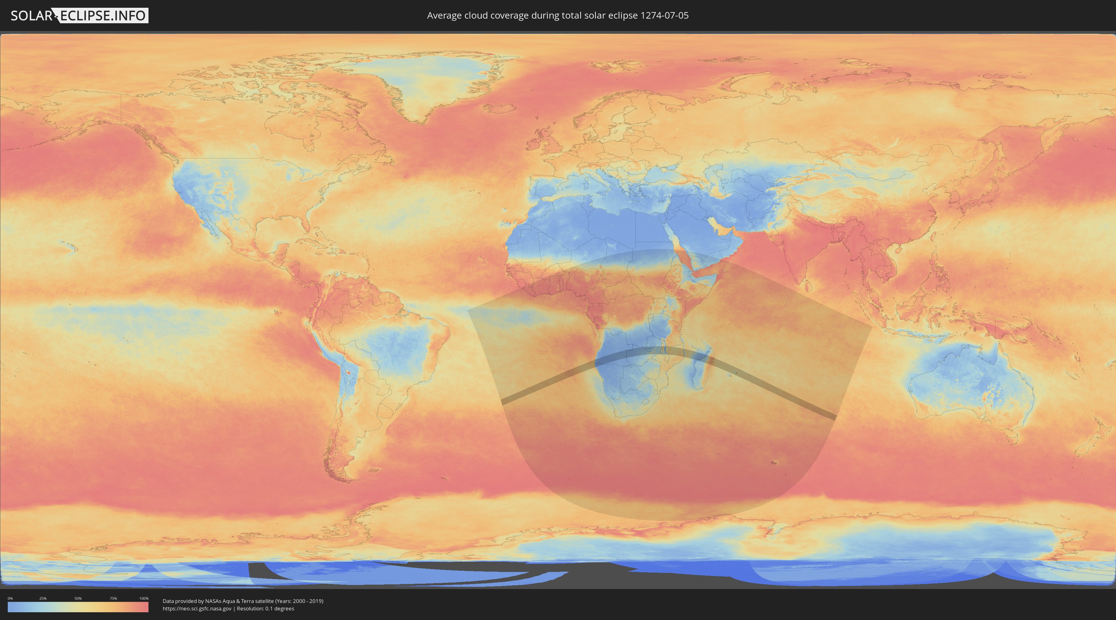
How will be the weather during the total solar eclipse on 07/05/1274?
Where is the best place to see the total solar eclipse of 07/05/1274?
The following maps show the average cloud coverage for the day of the total solar eclipse.
With the help of these maps, it is possible to find the place along the eclipse path, which has the best
chance of a cloudless sky.
Nevertheless, you should consider local circumstances and inform about the weather of your chosen
observation site.
The data is provided by NASAs satellites
AQUA and TERRA.
The cloud maps are averaged over a period of 19 years (2000 - 2019).
Detailed country maps
 Angola
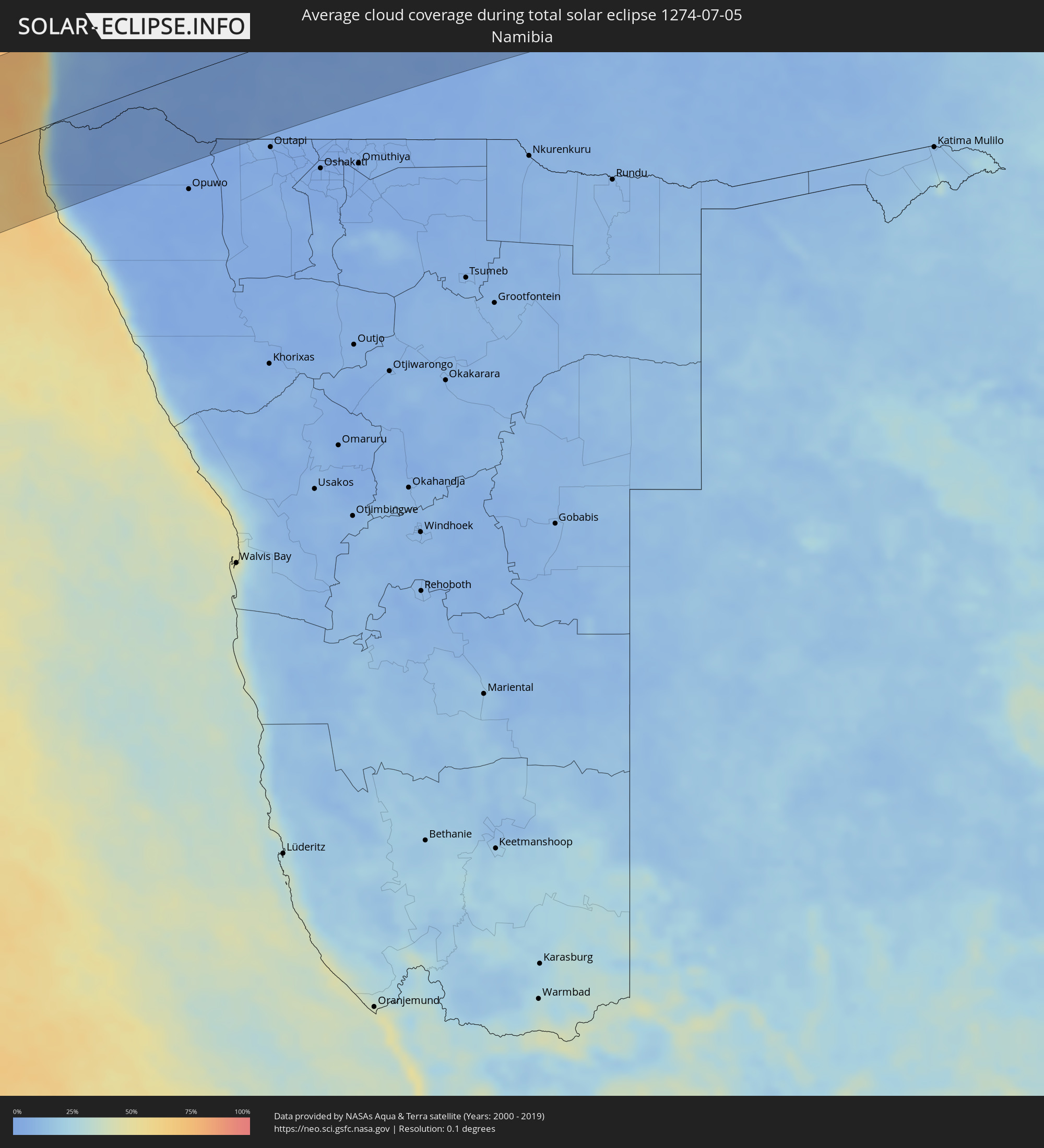 Namibia
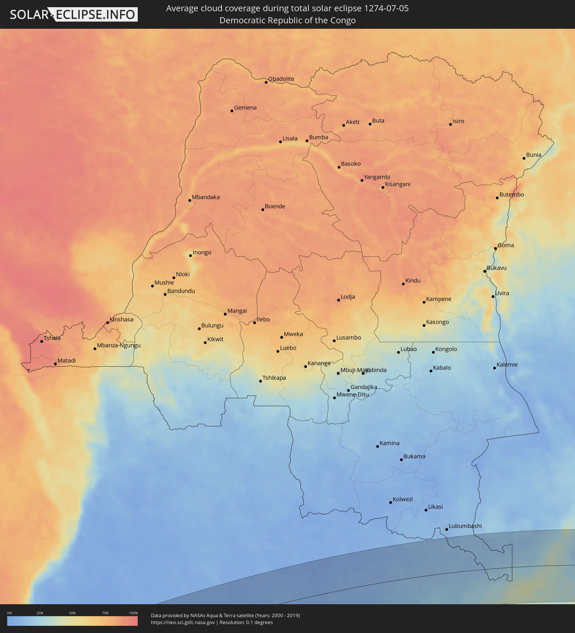 Democratic Republic of the Congo
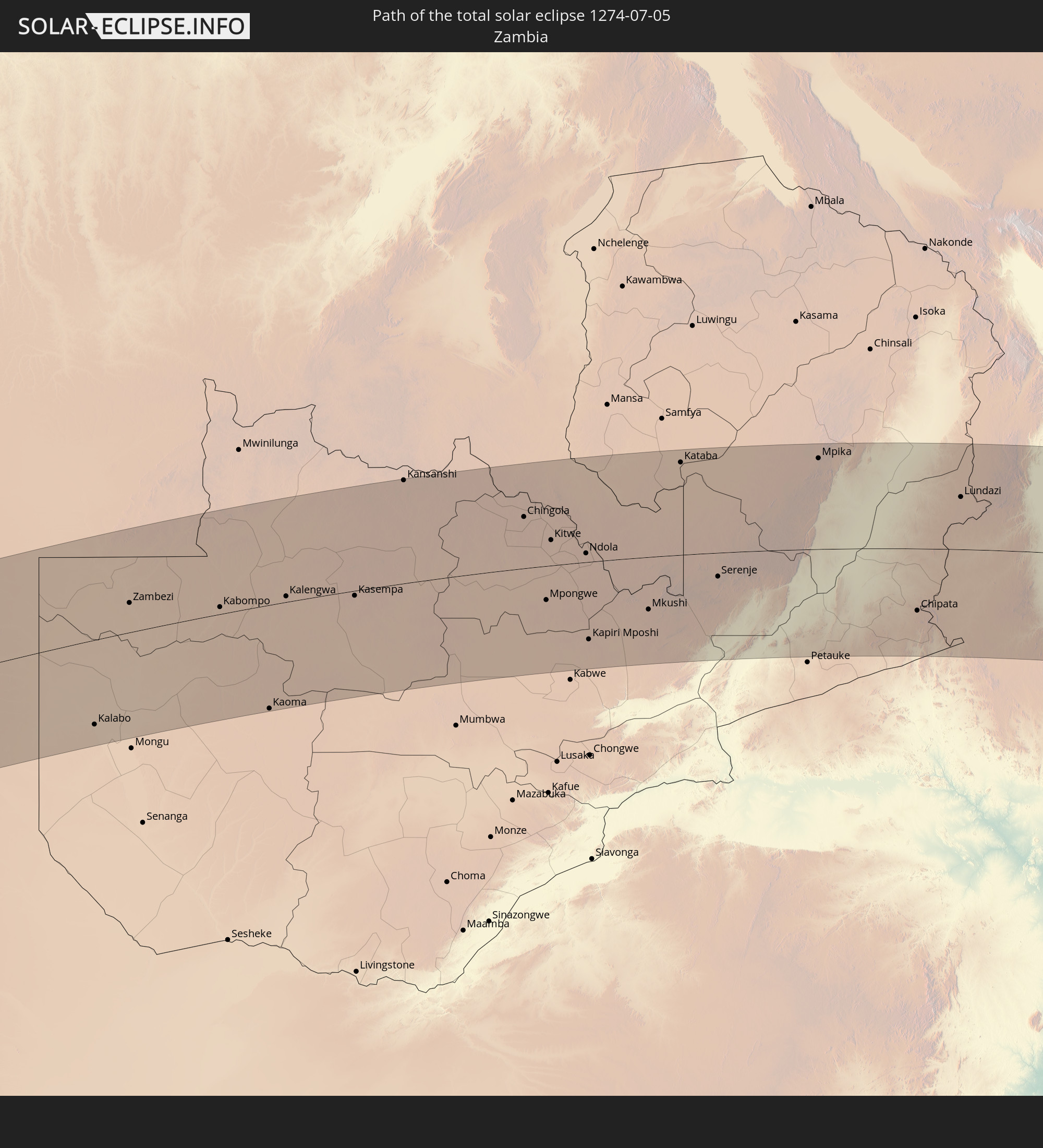
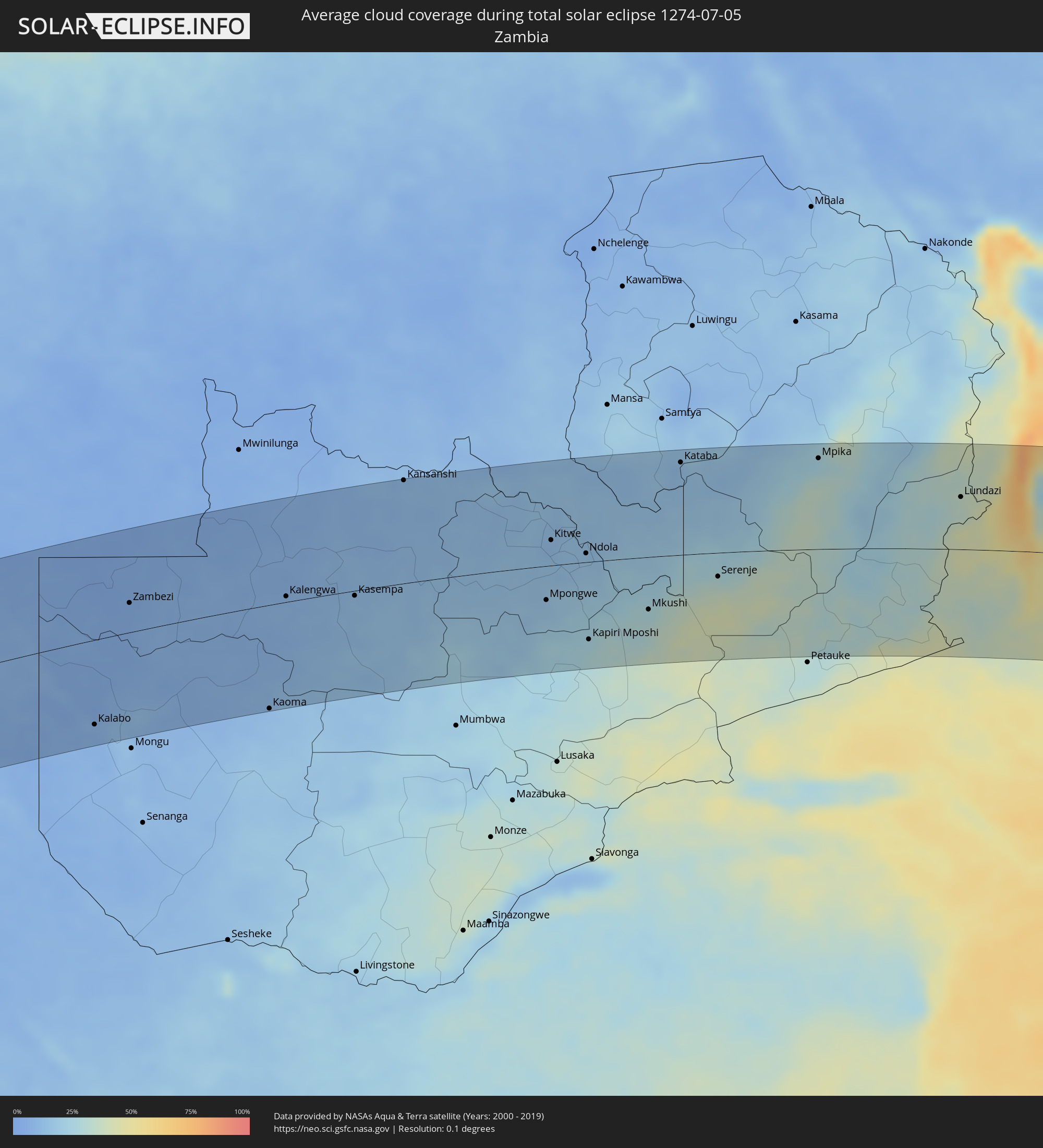 Zambia
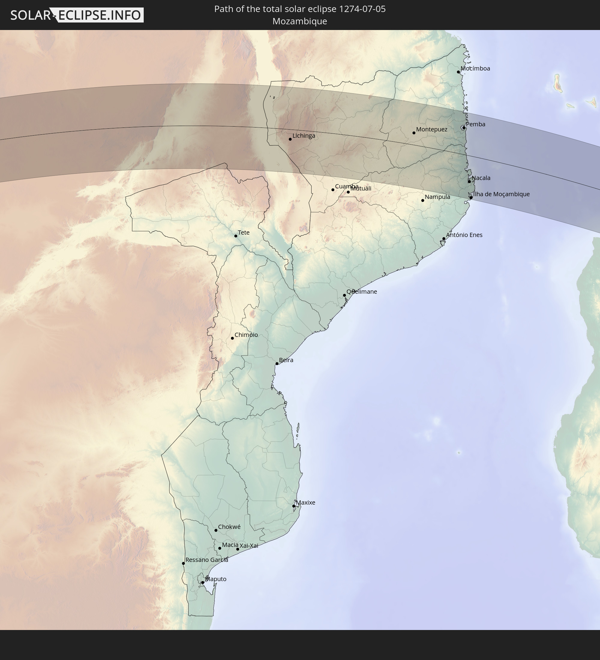
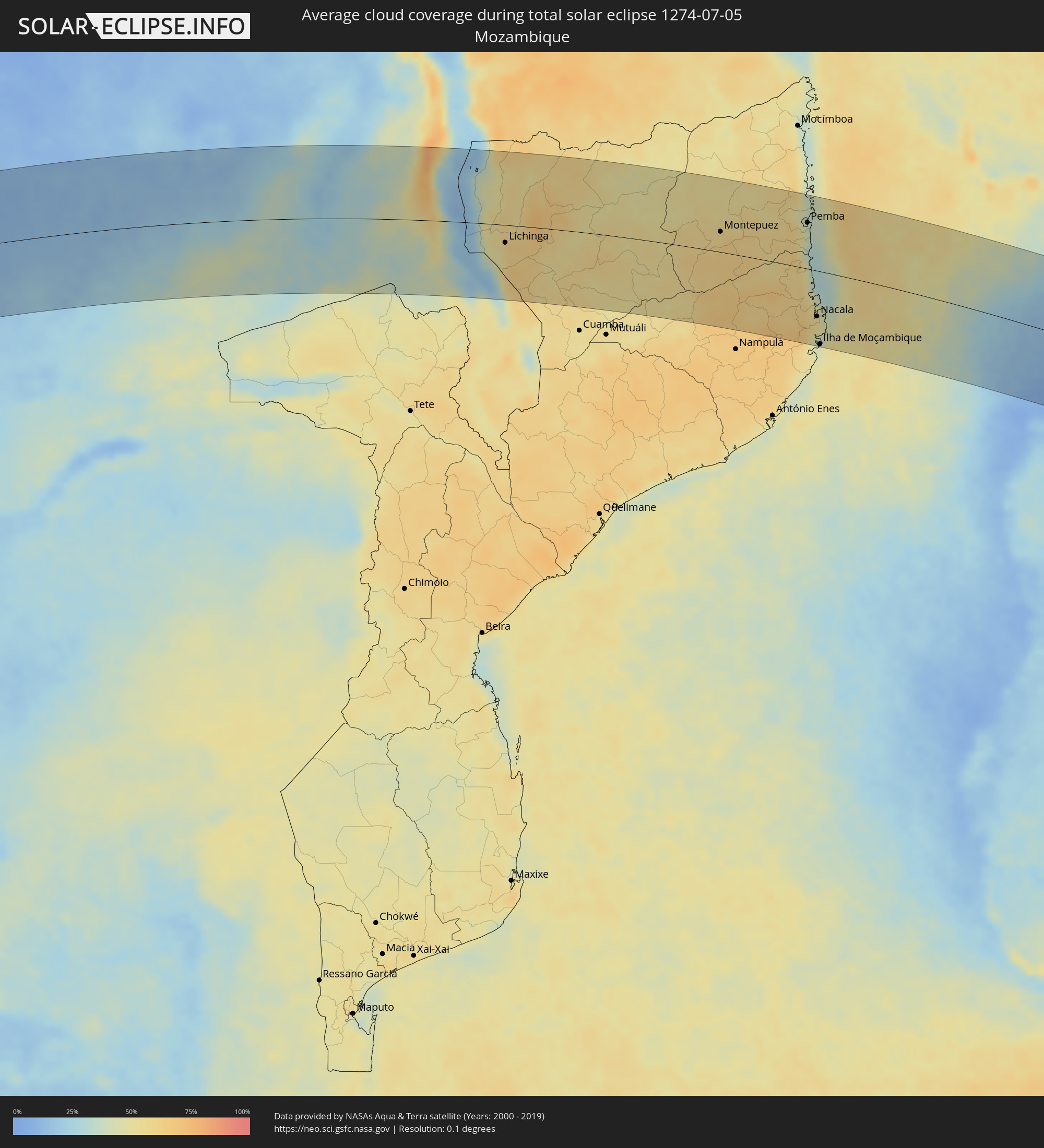 Mozambique
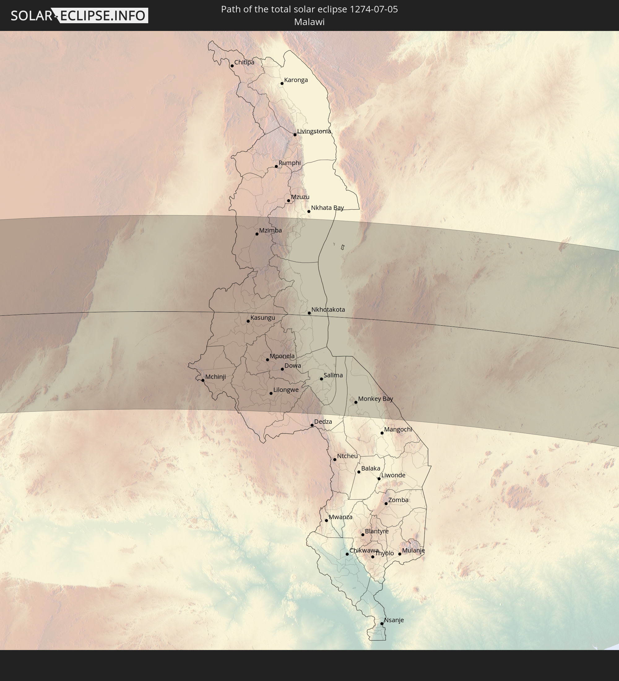
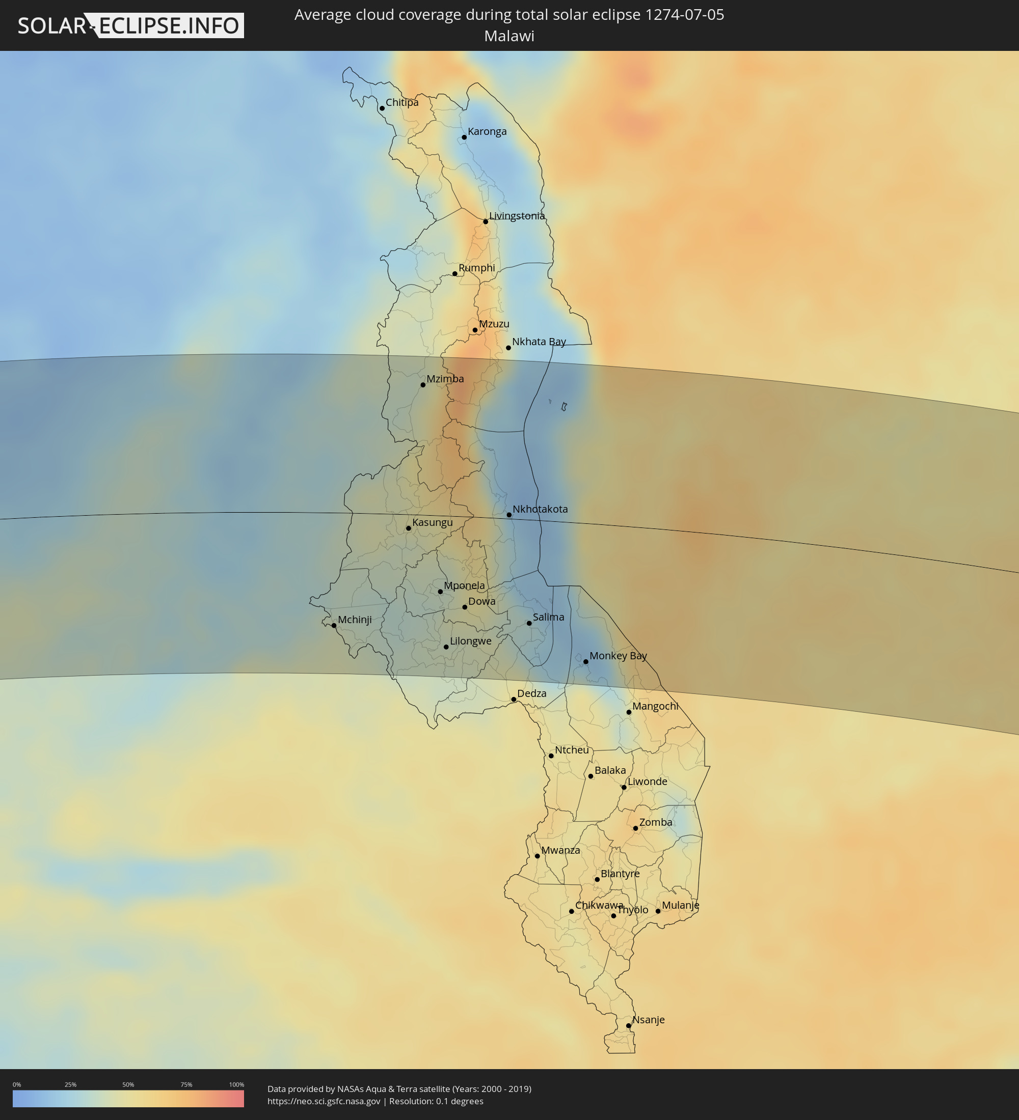 Malawi
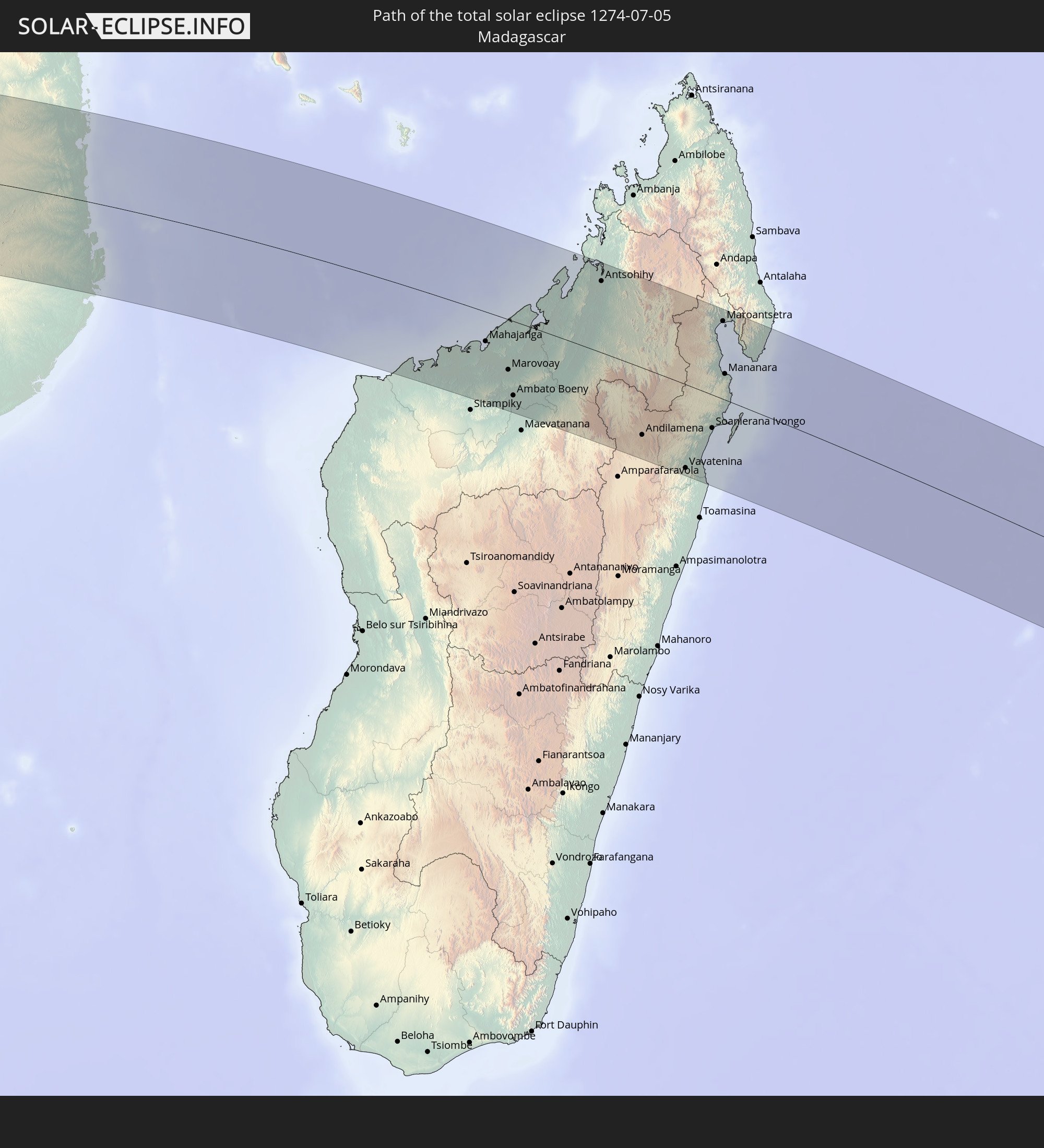
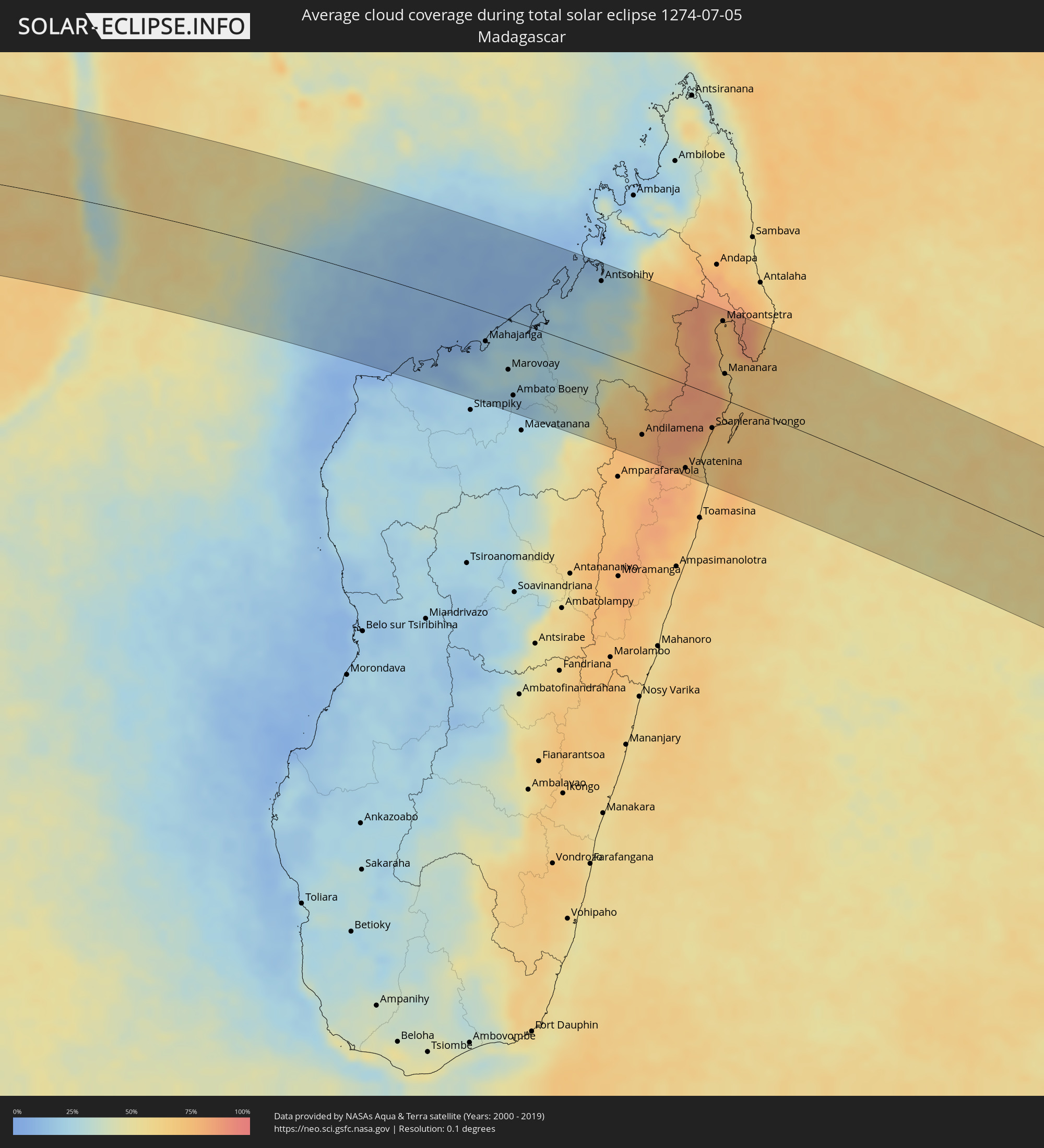 Madagascar
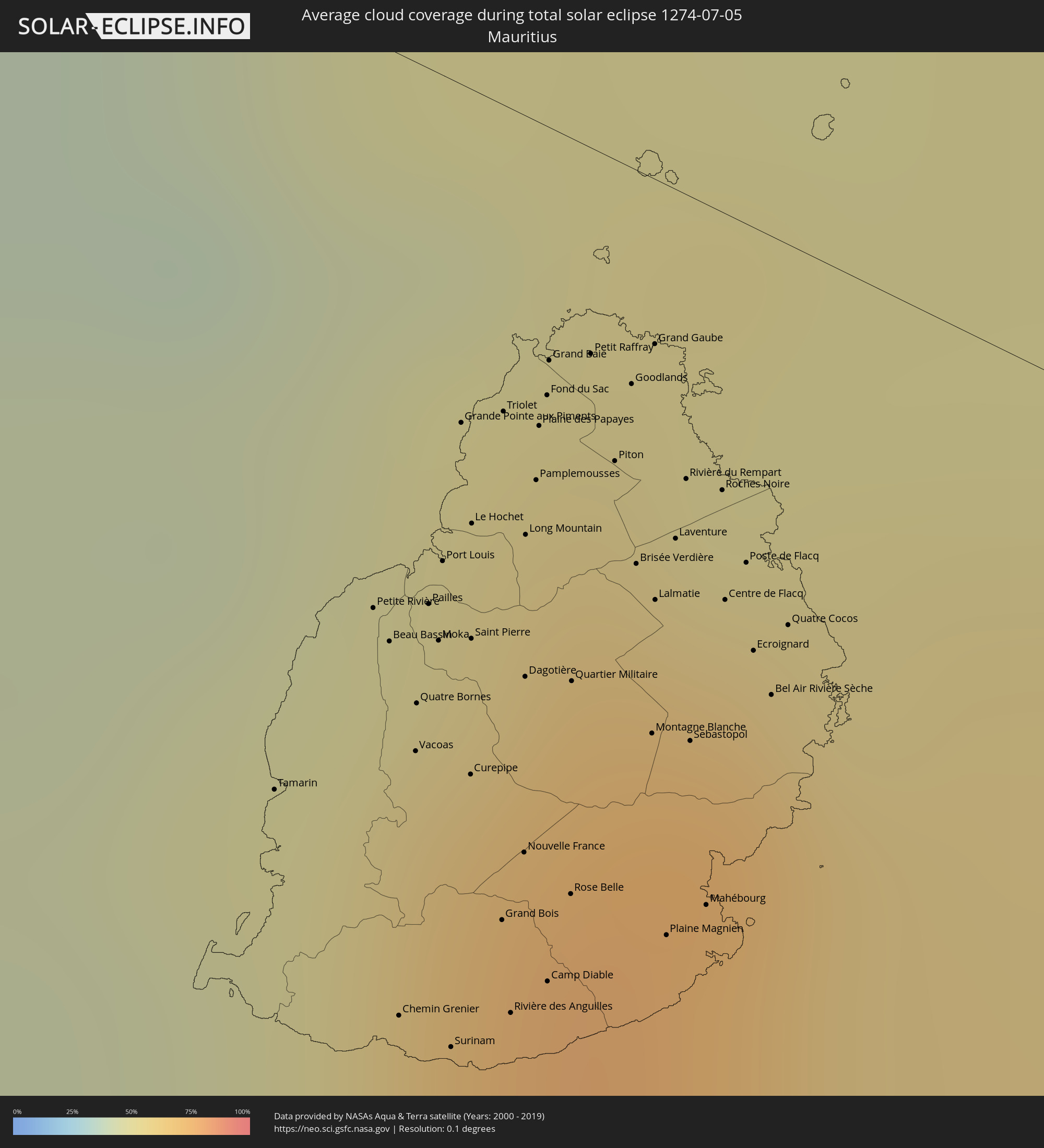 Mauritius
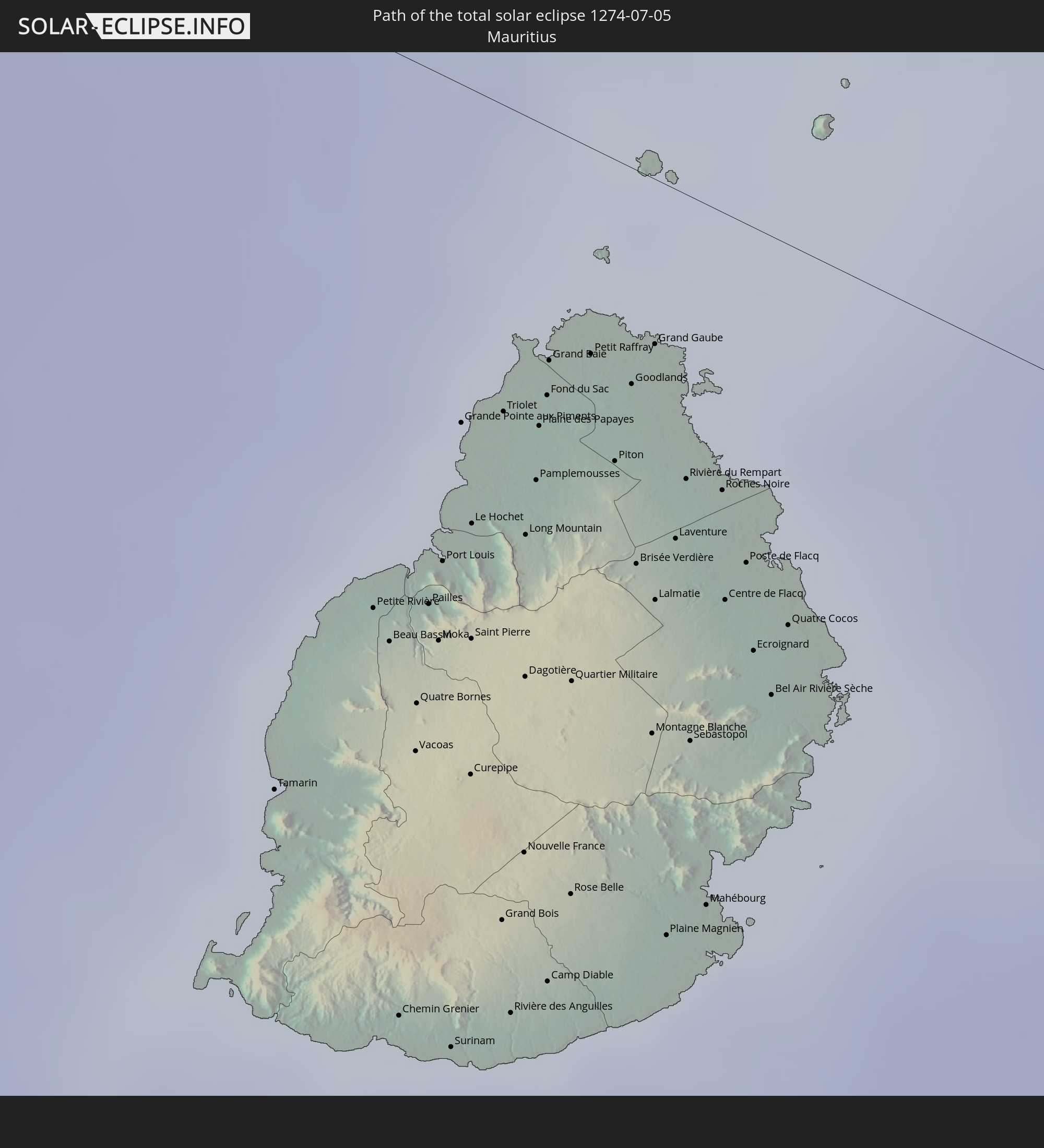
Cities inside the path of the eclipse
The following table shows all locations with a population of more than 5,000 inside the eclipse path. Cities which have more than 100,000 inhabitants are marked bold. A click at the locations opens a detailed map.
| City | Type | Eclipse duration | Local time of max. eclipse | Distance to central line | Ø Cloud coverage |
|
Ondjiva, Cunene
|
total | - | 08:55:12 UTC+00:13 | 126 km | 3% |
|
Menongue, Cuando Cobango
|
total | - | 08:58:54 UTC+00:13 | 65 km | 5% |
|
Kalabo, Western
|
total | - | 11:08:09 UTC+02:10 | 108 km | 7% |
|
Zambezi, North-Western
|
total | - | 11:08:57 UTC+02:10 | 38 km | 5% |
|
Limulunga, Western
|
total | - | 11:09:24 UTC+02:10 | 132 km | 12% |
|
Mufumbwe, North-Western
|
total | - | 11:13:38 UTC+02:10 | 13 km | 8% |
|
Kaoma, Western
|
total | - | 11:13:53 UTC+02:10 | 133 km | 11% |
|
Kalengwa, North-Western
|
total | - | 11:14:09 UTC+02:10 | 7 km | 10% |
|
Kasempa, North-Western
|
total | - | 11:16:30 UTC+02:10 | 6 km | 12% |
|
Solwezi, North-Western
|
total | - | 11:17:50 UTC+02:10 | 127 km | 11% |
|
Kansanshi, North-Western
|
total | - | 11:17:56 UTC+02:10 | 134 km | 10% |
|
Kalulushi, Copperbelt
|
total | - | 11:22:58 UTC+02:10 | 30 km | 12% |
|
Mpongwe, Copperbelt
|
total | - | 11:23:17 UTC+02:10 | 44 km | 17% |
|
Kitwe, Copperbelt
|
total | - | 11:23:18 UTC+02:10 | 33 km | 11% |
|
Mufulira, Copperbelt
|
total | - | 11:23:20 UTC+02:10 | 61 km | 12% |
|
Luanshya, Copperbelt
|
total | - | 11:23:59 UTC+02:10 | 6 km | 14% |
|
Ndola, Copperbelt
|
total | - | 11:24:36 UTC+02:10 | 12 km | 16% |
|
Kapiri Mposhi, Central
|
total | - | 11:24:55 UTC+02:10 | 101 km | 27% |
|
Mkushi, Central
|
total | - | 11:27:01 UTC+02:10 | 69 km | 27% |
|
Kataba, Copperbelt
|
total | - | 11:27:50 UTC+02:10 | 122 km | 13% |
|
Serenje, Central
|
total | - | 11:29:29 UTC+02:10 | 31 km | 31% |
|
Mpika, Muchinga Province
|
total | - | 11:32:56 UTC+02:10 | 120 km | 27% |
|
Mchinji, Central Region
|
total | - | 11:37:47 UTC+02:10 | 99 km | 42% |
|
Lundazi, Eastern
|
total | - | 11:38:23 UTC+02:10 | 69 km | 36% |
|
Kasungu, Central Region
|
total | - | 11:39:29 UTC+02:10 | 13 km | 39% |
|
Mzimba, Northern Region
|
total | - | 11:39:36 UTC+02:10 | 114 km | 42% |
|
Mponela, Central Region
|
total | - | 11:40:24 UTC+02:10 | 67 km | 36% |
|
Lilongwe, Central Region
|
total | - | 11:40:39 UTC+02:10 | 115 km | 38% |
|
Ntchisi, Central Region
|
total | - | 11:40:57 UTC+02:10 | 66 km | 44% |
|
Dowa, Central Region
|
total | - | 11:41:03 UTC+02:10 | 80 km | 42% |
|
Nkhotakota, Central Region
|
total | - | 11:42:00 UTC+02:10 | 3 km | 27% |
|
Salima, Central Region
|
total | - | 11:42:42 UTC+02:10 | 91 km | 27% |
|
Monkey Bay, Southern Region
|
total | - | 11:44:12 UTC+02:10 | 121 km | 36% |
|
Lichinga, Niassa
|
total | - | 11:45:03 UTC+02:10 | 33 km | 54% |
|
Montepuez, Cabo Delgado
|
total | - | 11:56:41 UTC+02:10 | 38 km | 57% |
|
Pemba, Cabo Delgado
|
total | - | 12:01:17 UTC+02:10 | 85 km | 43% |
|
Nacala, Nampula
|
total | - | 12:02:08 UTC+02:10 | 84 km | 56% |
|
Ilha de Moçambique, Nampula
|
total | - | 12:02:23 UTC+02:10 | 134 km | 42% |
|
Mahajanga, Boeny
|
total | - | 12:35:28 UTC+02:27 | 43 km | 16% |
|
Marovoay, Boeny
|
total | - | 12:36:25 UTC+02:27 | 73 km | 29% |
|
Ambato Boeny, Boeny
|
total | - | 12:36:39 UTC+02:27 | 108 km | 21% |
|
Tsaratanana, Betsiboka
|
total | - | 12:39:11 UTC+02:27 | 109 km | 41% |
|
Antsohihy, Sofia
|
total | - | 12:39:47 UTC+02:27 | 104 km | 25% |
|
Bemaitso, Alaotra Mangoro
|
total | - | 12:41:24 UTC+02:27 | 105 km | 76% |
|
Andilamena, Alaotra Mangoro
|
total | - | 12:41:35 UTC+02:27 | 96 km | 76% |
|
Antsirabe Afovoany, Sofia
|
total | - | 12:42:28 UTC+02:27 | 29 km | 78% |
|
Sahatavy, Analanjirofo
|
total | - | 12:42:43 UTC+02:27 | 126 km | 81% |
|
Vohibinany, Atsinanana
|
total | - | 12:42:47 UTC+02:27 | 114 km | 80% |
|
Vavatenina, Analanjirofo
|
total | - | 12:43:13 UTC+02:27 | 119 km | 77% |
|
Fenoarivo Atsinanana, Analanjirofo
|
total | - | 12:43:44 UTC+02:27 | 102 km | 67% |
|
Mahavelona, Atsinanana
|
total | - | 12:44:01 UTC+02:27 | 130 km | 66% |
|
Soanierana Ivongo, Analanjirofo
|
total | - | 12:44:08 UTC+02:27 | 48 km | 70% |
|
Maroantsetra, Analanjirofo
|
total | - | 12:44:21 UTC+02:27 | 112 km | 71% |
|
Mananara, Analanjirofo
|
total | - | 12:44:30 UTC+02:27 | 37 km | 65% |
|
Antakotako, Analanjirofo
|
total | - | 12:44:29 UTC+02:27 | 127 km | 78% |
|
Ambodifotatra, Analanjirofo
|
total | - | 12:44:48 UTC+02:27 | 44 km | 67% |
|
Chemin Grenier, Savanne
|
total | - | 14:24:15 UTC+03:50 | 69 km | 63% |
|
Vacoas, Plaines Wilhems
|
total | - | 14:24:17 UTC+03:50 | 49 km | 68% |
|
Moka, Moka
|
total | - | 14:24:20 UTC+03:50 | 41 km | 64% |
|
Port Louis, Port Louis
|
total | - | 14:24:21 UTC+03:50 | 35 km | 64% |
|
Surinam, Savanne
|
total | - | 14:24:19 UTC+03:50 | 69 km | 63% |
|
Grande Pointe aux Piments, Pamplemousses
|
total | - | 14:24:23 UTC+03:50 | 24 km | 55% |
|
Terre Rouge, Pamplemousses
|
total | - | 14:24:24 UTC+03:50 | 30 km | 55% |
|
Grand Bois, Savanne
|
total | - | 14:24:24 UTC+03:50 | 58 km | 71% |
|
Rivière des Anguilles, Savanne
|
total | - | 14:24:25 UTC+03:50 | 65 km | 63% |
|
Morcellemont Saint André, Pamplemousses
|
total | - | 14:24:28 UTC+03:50 | 23 km | 65% |
|
Nouvelle France, Grand Port
|
total | - | 14:24:27 UTC+03:50 | 53 km | 75% |
|
Dagotière, Moka
|
total | - | 14:24:27 UTC+03:50 | 40 km | 74% |
|
Long Mountain, Pamplemousses
|
total | - | 14:24:28 UTC+03:50 | 30 km | 65% |
|
Pamplemousses, Pamplemousses
|
total | - | 14:24:29 UTC+03:50 | 26 km | 65% |
|
Plaine des Papayes, Pamplemousses
|
total | - | 14:24:30 UTC+03:50 | 22 km | 65% |
|
Fond du Sac, Pamplemousses
|
total | - | 14:24:30 UTC+03:50 | 19 km | 57% |
|
Quartier Militaire, Moka
|
total | - | 14:24:31 UTC+03:50 | 39 km | 74% |
|
Petit Raffray, Rivière du Rempart
|
total | - | 14:24:34 UTC+03:50 | 15 km | 57% |
|
New Grove, Grand Port
|
total | - | 14:24:32 UTC+03:50 | 54 km | 75% |
|
Piton, Rivière du Rempart
|
total | - | 14:24:36 UTC+03:50 | 22 km | 65% |
|
Goodlands, Rivière du Rempart
|
total | - | 14:24:38 UTC+03:50 | 16 km | 57% |
|
Brisée Verdière, Flacq
|
total | - | 14:24:38 UTC+03:50 | 28 km | 74% |
|
Bon Accueil, Flacq
|
total | - | 14:24:39 UTC+03:50 | 28 km | 74% |
|
Montagne Blanche
|
total | - | 14:24:38 UTC+03:50 | 40 km | 72% |
|
Grand Gaube, Rivière du Rempart
|
total | - | 14:24:40 UTC+03:50 | 12 km | 52% |
|
Lalmatie, Flacq
|
total | - | 14:24:39 UTC+03:50 | 30 km | 74% |
|
Laventure, Flacq
|
total | - | 14:24:41 UTC+03:50 | 25 km | 63% |
|
Sebastopol, Flacq
|
total | - | 14:24:42 UTC+03:50 | 39 km | 72% |
|
Beau Vallon, Grand Port
|
total | - | 14:24:42 UTC+03:50 | 51 km | 66% |
|
Mahébourg, Grand Port
|
total | - | 14:24:42 UTC+03:50 | 50 km | 66% |
|
Roches Noire, Rivière du Rempart
|
total | - | 14:24:45 UTC+03:50 | 20 km | 63% |
|
Centre de Flacq, Flacq
|
total | - | 14:24:45 UTC+03:50 | 28 km | 74% |
|
Poste de Flacq, Flacq
|
total | - | 14:24:47 UTC+03:50 | 24 km | 74% |
|
Ecroignard, Flacq
|
total | - | 14:24:47 UTC+03:50 | 30 km | 74% |