Total solar eclipse of 10/28/1296
| Day of week: | Sunday |
| Maximum duration of eclipse: | 02m41s |
| Maximum width of eclipse path: | 100 km |
| Saros cycle: | 112 |
| Coverage: | 100% |
| Magnitude: | 1.0289 |
| Gamma: | 0.1946 |
Wo kann man die Sonnenfinsternis vom 10/28/1296 sehen?
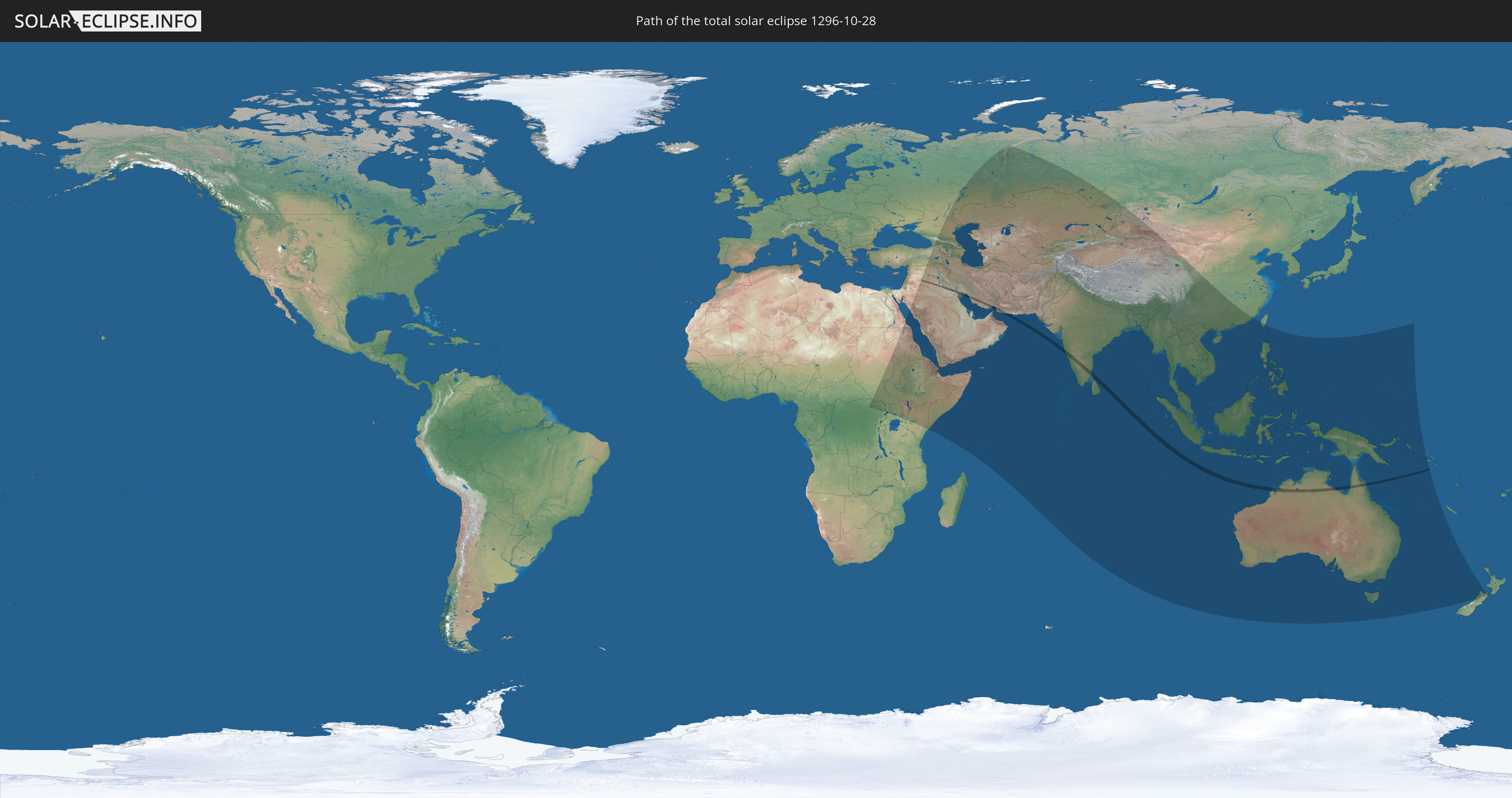
Die Sonnenfinsternis am 10/28/1296 kann man in 68 Ländern als partielle Sonnenfinsternis beobachten.
Der Finsternispfad verläuft durch 5 Länder. Nur in diesen Ländern ist sie als total Sonnenfinsternis zu sehen.
In den folgenden Ländern ist die Sonnenfinsternis total zu sehen
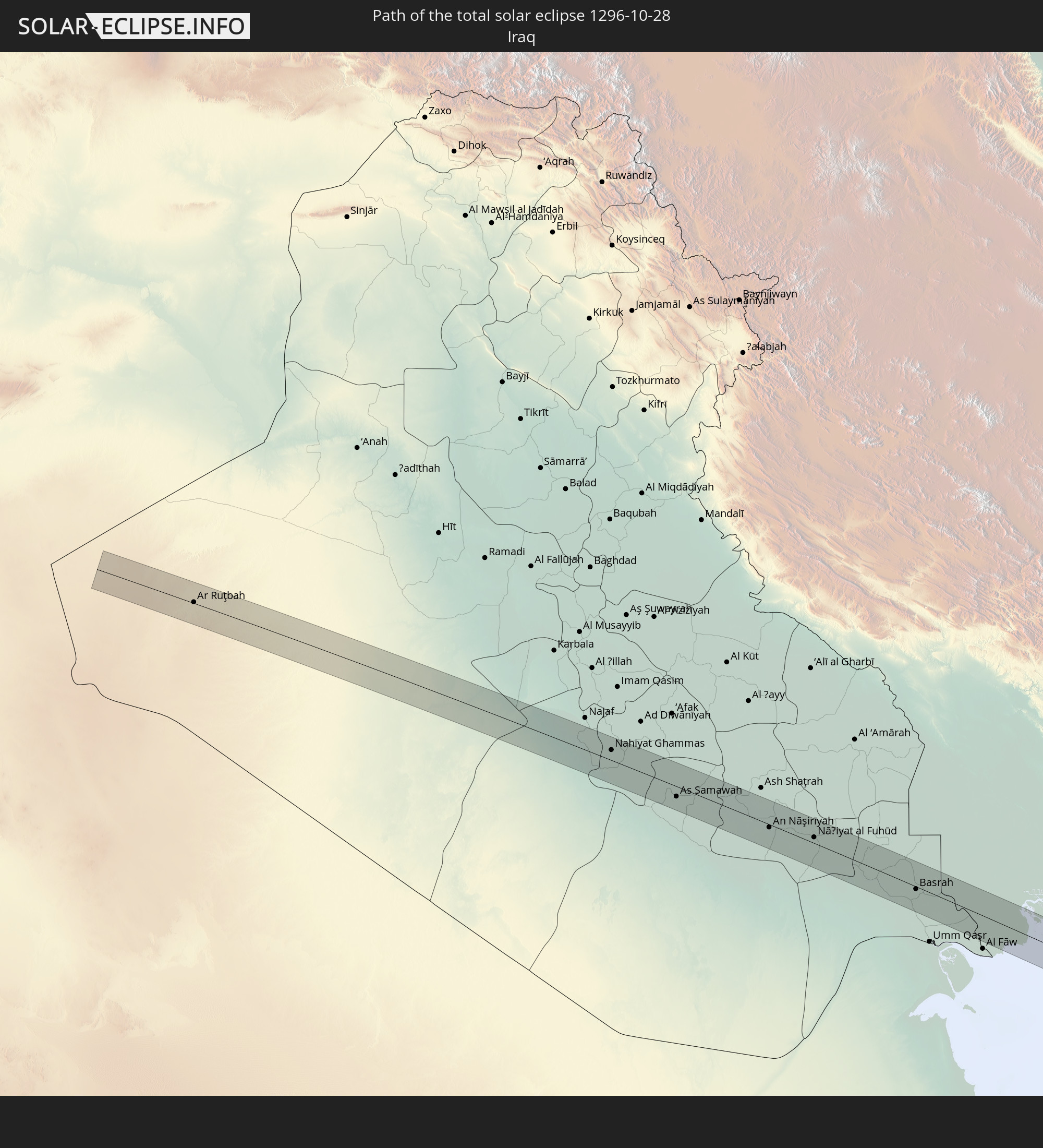 Iraq
Iraq
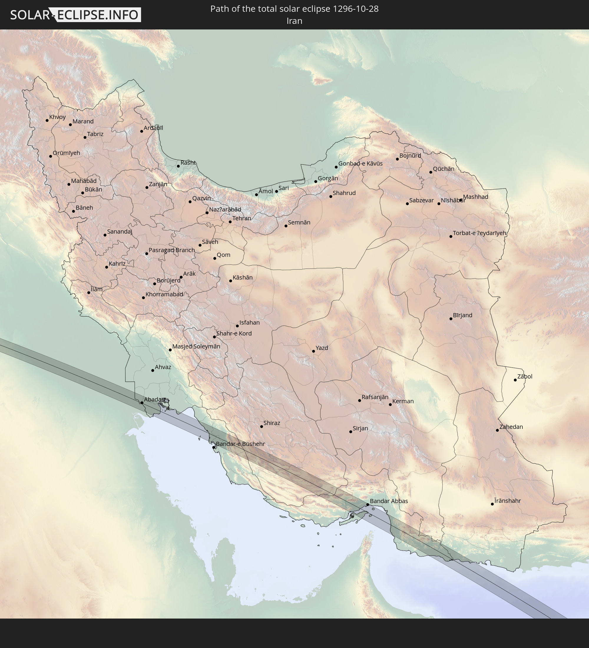 Iran
Iran
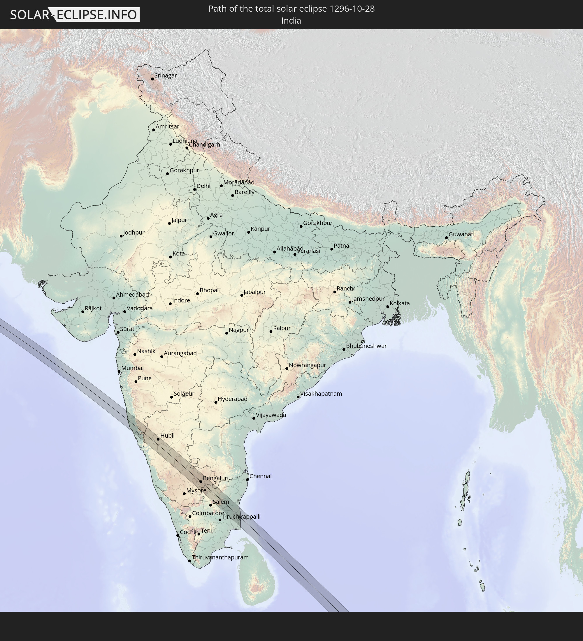 India
India
 Australia
 Solomon Islands
In den folgenden Ländern ist die Sonnenfinsternis partiell zu sehen
 Russia
 New Zealand
 Democratic Republic of the Congo
 Sudan
Sudan
 Egypt
Egypt
 Turkey
 Uganda
 Ethiopia
 Kenya
Kenya
 Saudi Arabia
 Jordan
 Syria
Syria
 Eritrea
 Iraq
Iraq
 Georgia
 Somalia
 Djibouti
 Yemen
Yemen
 Armenia
 Iran
Iran
 Azerbaijan
 Seychelles
 Kazakhstan
 Kuwait
 Bahrain
 Qatar
Qatar
 United Arab Emirates
 Oman
Oman
 Turkmenistan
 Uzbekistan
 Mauritius
 Afghanistan
 Pakistan
 Tajikistan
 India
India
 Kyrgyzstan
 British Indian Ocean Territory
 Maldives
 China
China
 Sri Lanka
 Nepal
Nepal
 Mongolia
 Bangladesh
 Bhutan
 Myanmar
 Indonesia
 Cocos Islands
 Thailand
 Malaysia
 Laos
Laos
 Vietnam
 Cambodia
 Singapore
 Christmas Island
 Australia
 Macau
Macau
 Hong Kong
 Brunei
 Taiwan
 Philippines
 East Timor
 Palau
Palau
 Federated States of Micronesia
 Papua New Guinea
 Guam
Guam
 Northern Mariana Islands
 Solomon Islands
 New Caledonia
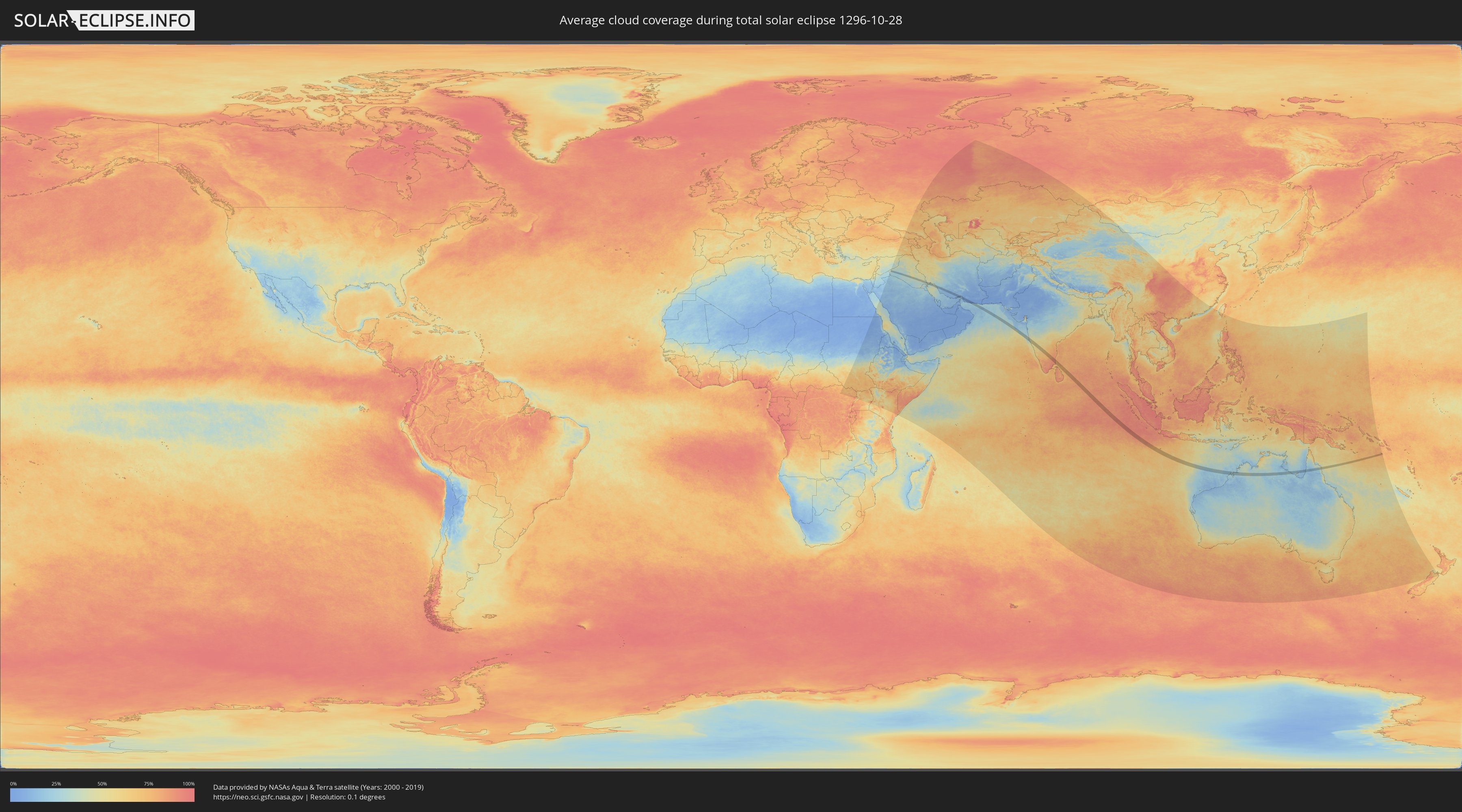
How will be the weather during the total solar eclipse on 10/28/1296?
Where is the best place to see the total solar eclipse of 10/28/1296?
The following maps show the average cloud coverage for the day of the total solar eclipse.
With the help of these maps, it is possible to find the place along the eclipse path, which has the best
chance of a cloudless sky.
Nevertheless, you should consider local circumstances and inform about the weather of your chosen
observation site.
The data is provided by NASAs satellites
AQUA and TERRA.
The cloud maps are averaged over a period of 19 years (2000 - 2019).

Detailed country maps
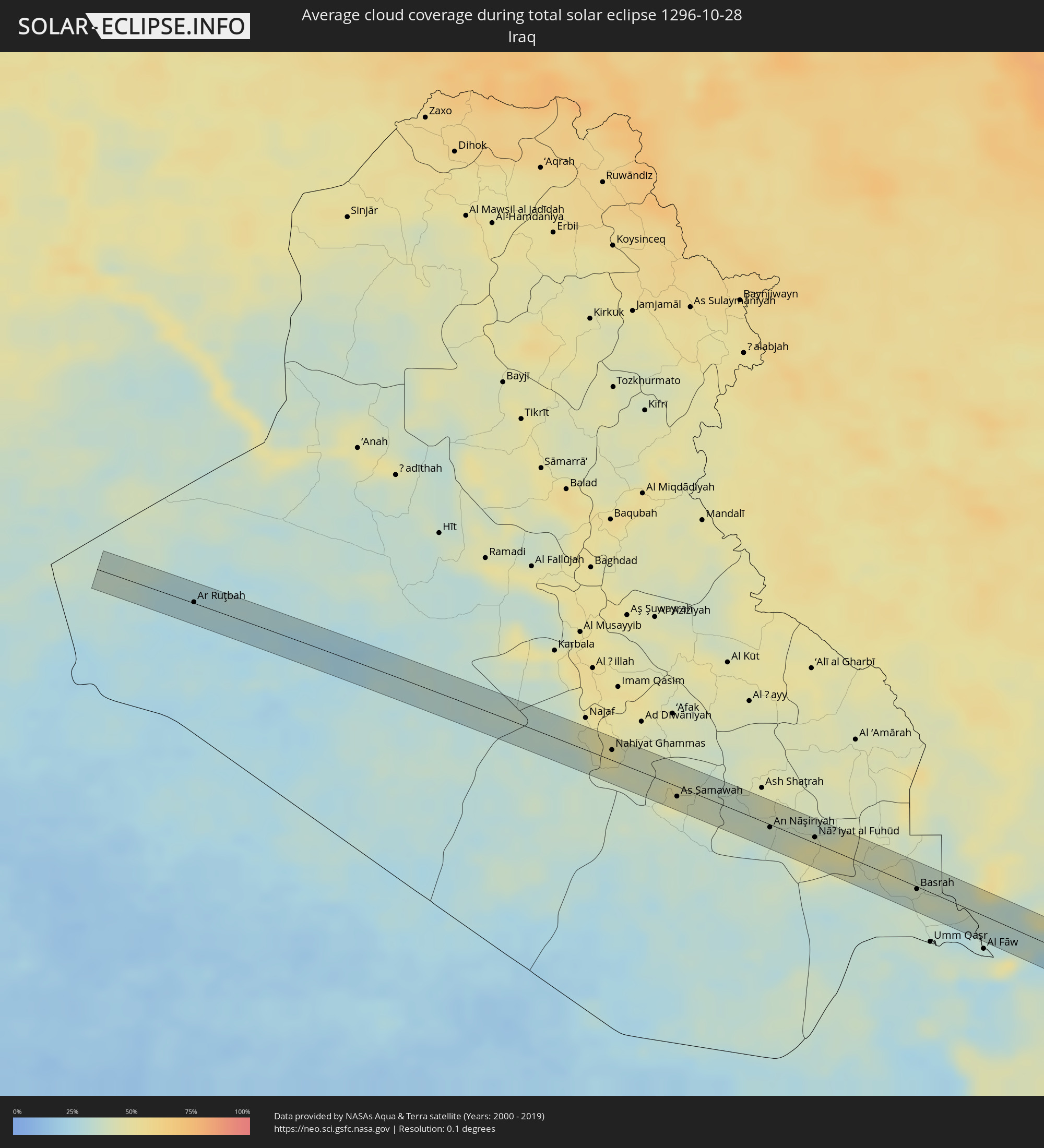 Iraq
Iraq
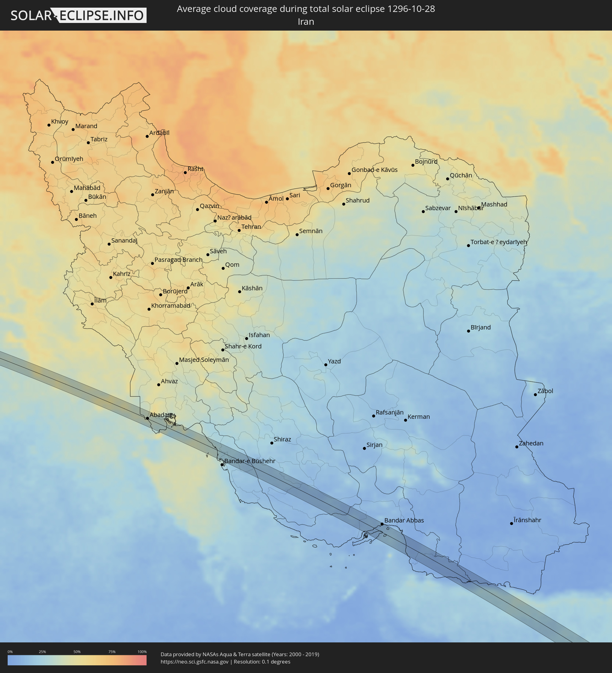 Iran
Iran
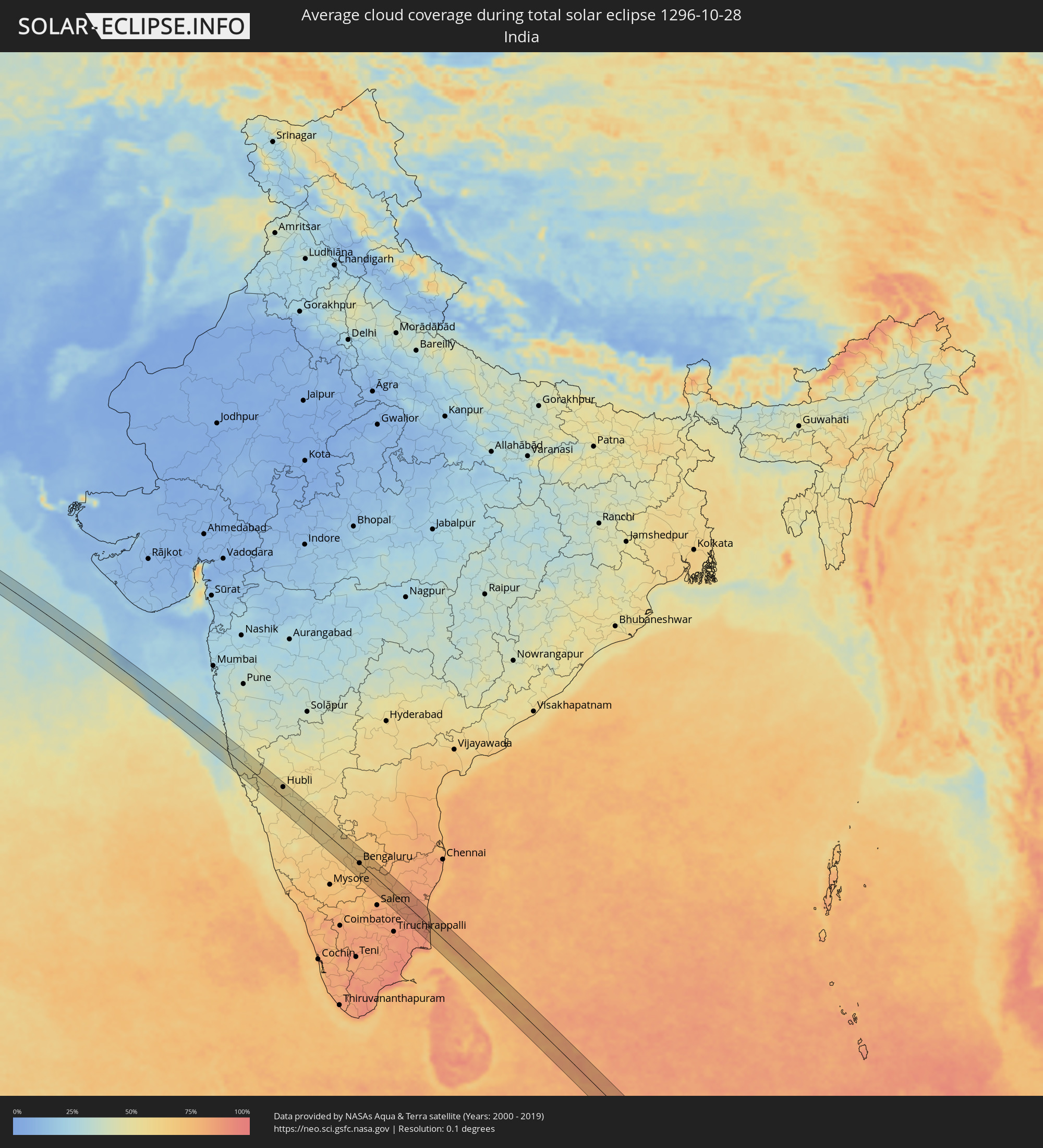 India
India
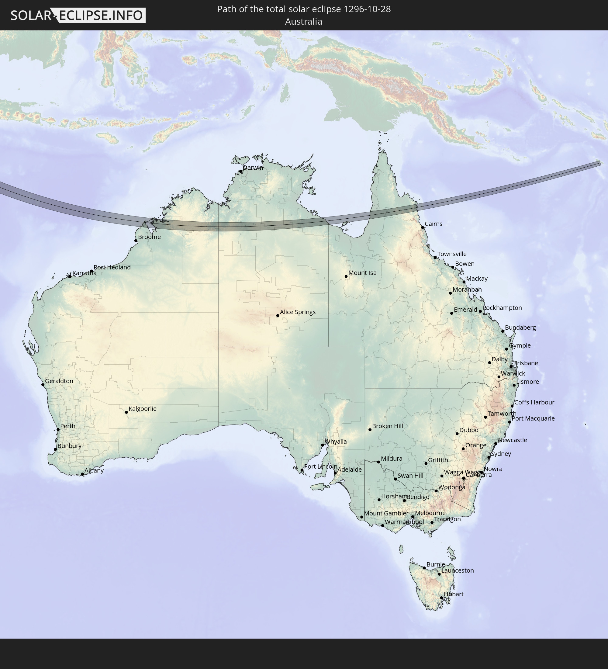
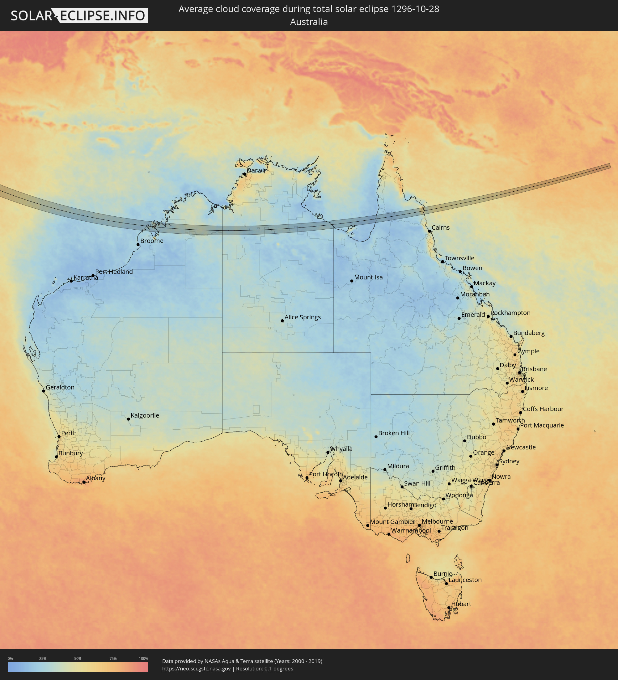 Australia
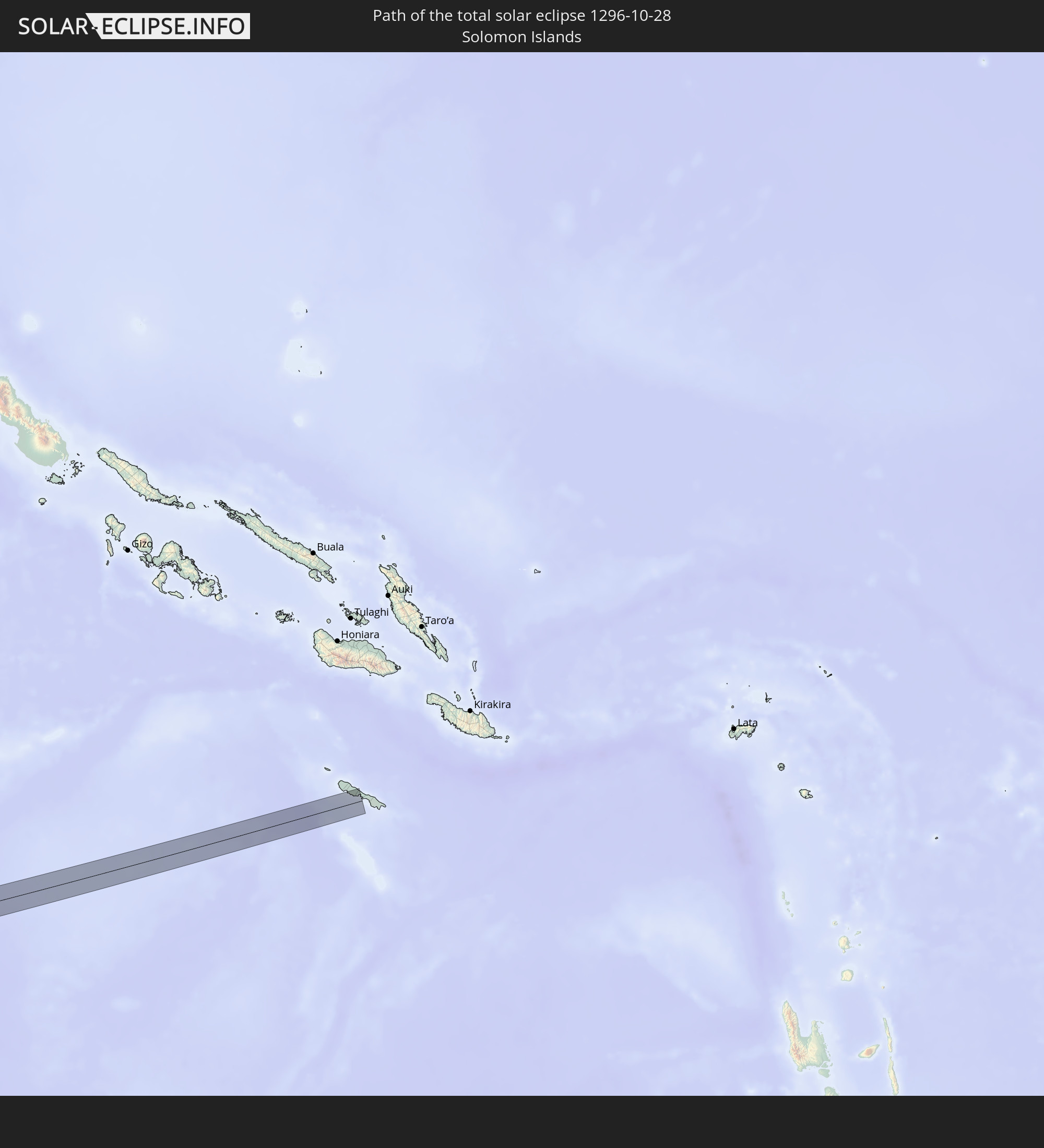
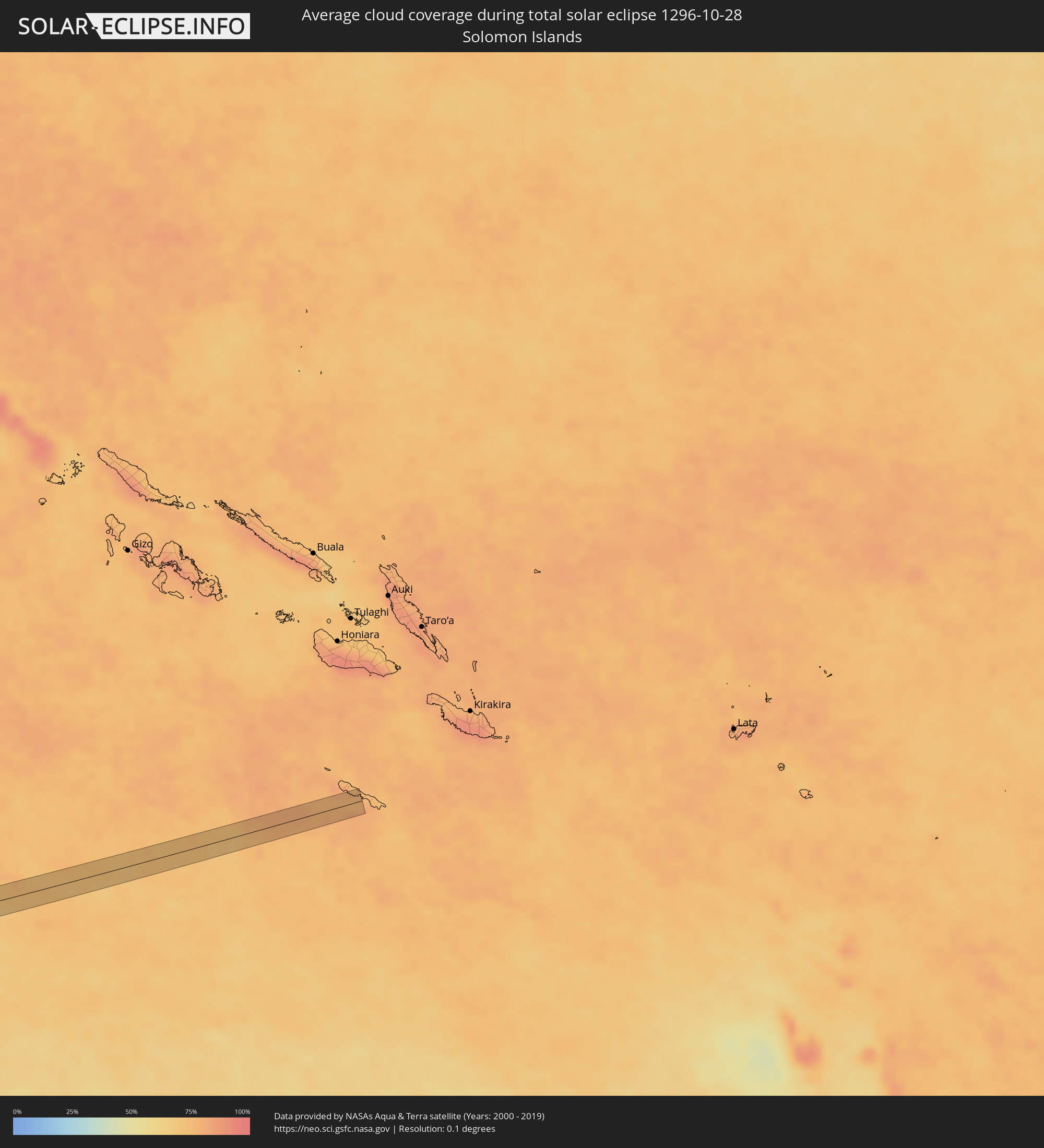 Solomon Islands
Cities inside the path of the eclipse
The following table shows all locations with a population of more than 5,000 inside the eclipse path. Cities which have more than 100,000 inhabitants are marked bold. A click at the locations opens a detailed map.
| City | Type | Eclipse duration | Local time of max. eclipse | Distance to central line | Ø Cloud coverage |
|
Ar Ruţbah, Anbar
|
total | - | 06:47:36 UTC+02:57 | 1 km | 26% |
|
Al Mishkhāb, An Najaf
|
total | - | 06:47:58 UTC+02:57 | 11 km | 49% |
|
Nahiyat Ghammas, Al Qādisīyah
|
total | - | 06:47:59 UTC+02:57 | 9 km | 45% |
|
Nāḩiyat ash Shināfīyah, Al Qādisīyah
|
total | - | 06:47:59 UTC+02:57 | 6 km | 39% |
|
Ar Rumaythah, Al Muthanná
|
total | - | 06:48:05 UTC+02:57 | 8 km | 48% |
|
As Samawah, Al Muthanná
|
total | - | 06:48:05 UTC+02:57 | 9 km | 38% |
|
An Nāşirīyah, Dhi Qar
|
total | - | 06:48:16 UTC+02:57 | 3 km | 38% |
|
Nāḩiyat al Fuhūd, Dhi Qar
|
total | - | 06:48:22 UTC+02:57 | 5 km | 47% |
|
Az Zubayr, Basra Governorate
|
total | - | 06:48:37 UTC+02:57 | 17 km | 37% |
|
Al Hārithah, Basra Governorate
|
total | - | 06:48:37 UTC+02:57 | 5 km | 40% |
|
Basrah, Basra Governorate
|
total | - | 06:48:37 UTC+02:57 | 2 km | 39% |
|
Al Başrah al Qadīmah, Basra Governorate
|
total | - | 06:48:38 UTC+02:57 | 2 km | 39% |
|
Khorramshahr, Khuzestan
|
total | - | 07:16:52 UTC+03:25 | 6 km | 39% |
|
Abadan, Khuzestan
|
total | - | 07:16:54 UTC+03:25 | 1 km | 35% |
|
Bandar-e Ganāveh, Bushehr
|
total | - | 07:17:35 UTC+03:25 | 11 km | 32% |
|
Borāzjān, Bushehr
|
total | - | 07:17:51 UTC+03:25 | 8 km | 22% |
|
Fīrūzābād, Fars
|
total | - | 07:18:23 UTC+03:25 | 23 km | 15% |
|
Qeshm, Hormozgan
|
total | - | 07:20:23 UTC+03:25 | 0 km | 19% |
|
Bandar Abbas, Hormozgan
|
total | - | 07:20:19 UTC+03:25 | 24 km | 14% |
|
Mālvan, Maharashtra
|
total | - | 09:36:48 UTC+05:21 | 26 km | 44% |
|
Sāvantvādi, Maharashtra
|
total | - | 09:37:23 UTC+05:21 | 15 km | 50% |
|
Ajra, Maharashtra
|
total | - | 09:37:38 UTC+05:21 | 29 km | 50% |
|
Belgaum, Karnataka
|
total | - | 09:38:16 UTC+05:21 | 27 km | 55% |
|
Khānāpur, Karnataka
|
total | - | 09:38:30 UTC+05:21 | 9 km | 50% |
|
Dandeli, Karnataka
|
total | - | 09:39:02 UTC+05:21 | 16 km | 53% |
|
Yellāpur, Karnataka
|
total | - | 09:39:28 UTC+05:21 | 35 km | 52% |
|
Alnāvar, Karnataka
|
total | - | 09:39:00 UTC+05:21 | 6 km | 57% |
|
Haliyal, Karnataka
|
total | - | 09:39:08 UTC+05:21 | 1 km | 58% |
|
Mundgod, Karnataka
|
total | - | 09:39:52 UTC+05:21 | 12 km | 54% |
|
Hāngal, Karnataka
|
total | - | 09:40:13 UTC+05:21 | 24 km | 56% |
|
Hubli, Karnataka
|
total | - | 09:39:35 UTC+05:21 | 27 km | 56% |
|
Kundgol, Karnataka
|
total | - | 09:39:49 UTC+05:21 | 27 km | 55% |
|
Savanūr, Karnataka
|
total | - | 09:40:15 UTC+05:21 | 9 km | 54% |
|
Hirekerūr, Karnataka
|
total | - | 09:40:54 UTC+05:21 | 31 km | 57% |
|
Hāveri, Karnataka
|
total | - | 09:40:32 UTC+05:21 | 2 km | 55% |
|
Lakshmeshwar, Karnataka
|
total | - | 09:40:15 UTC+05:21 | 31 km | 54% |
|
Byādgi, Karnataka
|
total | - | 09:40:47 UTC+05:21 | 6 km | 55% |
|
Rānībennur, Karnataka
|
total | - | 09:41:01 UTC+05:21 | 1 km | 57% |
|
Honnāli, Karnataka
|
total | - | 09:41:28 UTC+05:21 | 32 km | 57% |
|
Harihar, Karnataka
|
total | - | 09:41:22 UTC+05:21 | 2 km | 55% |
|
Channagiri, Karnataka
|
total | - | 09:42:05 UTC+05:21 | 31 km | 58% |
|
Harpanahalli, Karnataka
|
total | - | 09:41:17 UTC+05:21 | 38 km | 57% |
|
Hosdurga, Karnataka
|
total | - | 09:42:50 UTC+05:21 | 25 km | 59% |
|
Chitradurga, Karnataka
|
total | - | 09:42:29 UTC+05:21 | 20 km | 59% |
|
Hiriyūr, Karnataka
|
total | - | 09:43:05 UTC+05:21 | 11 km | 60% |
|
Chiknāyakanhalli, Karnataka
|
total | - | 09:43:44 UTC+05:21 | 33 km | 65% |
|
Sīra, Karnataka
|
total | - | 09:43:43 UTC+05:21 | 15 km | 63% |
|
Gubbi, Karnataka
|
total | - | 09:44:17 UTC+05:21 | 19 km | 68% |
|
Kunigal, Karnataka
|
total | - | 09:44:45 UTC+05:21 | 37 km | 69% |
|
Tumkūr, Karnataka
|
total | - | 09:44:28 UTC+05:21 | 5 km | 66% |
|
Maddagiri, Karnataka
|
total | - | 09:44:14 UTC+05:21 | 30 km | 65% |
|
Māgadi, Karnataka
|
total | - | 09:45:06 UTC+05:21 | 28 km | 67% |
|
Nelamangala, Karnataka
|
total | - | 09:45:10 UTC+05:21 | 4 km | 70% |
|
Dod Ballāpur, Karnataka
|
total | - | 09:45:07 UTC+05:21 | 23 km | 66% |
|
Bengaluru, Karnataka
|
total | - | 09:45:36 UTC+05:21 | 1 km | 72% |
|
Anekal, Karnataka
|
total | - | 09:46:04 UTC+05:21 | 15 km | 72% |
|
Devanhalli, Karnataka
|
total | - | 09:45:25 UTC+05:21 | 31 km | 70% |
|
Denkanikota, Tamil Nadu
|
total | - | 09:46:25 UTC+05:21 | 23 km | 74% |
|
Hoskote, Karnataka
|
total | - | 09:45:45 UTC+05:21 | 23 km | 73% |
|
Hosūr, Tamil Nadu
|
total | - | 09:46:13 UTC+05:21 | 3 km | 73% |
|
Mālūr, Karnataka
|
total | - | 09:46:02 UTC+05:21 | 27 km | 74% |
|
Pālakkodu, Tamil Nadu
|
total | - | 09:47:06 UTC+05:21 | 21 km | 79% |
|
Dharmapuri, Tamil Nadu
|
total | - | 09:47:28 UTC+05:21 | 30 km | 78% |
|
Krishnagiri, Tamil Nadu
|
total | - | 09:47:02 UTC+05:21 | 7 km | 77% |
|
Kuppam, Andhra Pradesh
|
total | - | 09:46:55 UTC+05:21 | 35 km | 77% |
|
Pallippatti, Tamil Nadu
|
total | - | 09:48:03 UTC+05:21 | 28 km | 79% |
|
Harūr, Tamil Nadu
|
total | - | 09:48:01 UTC+05:21 | 13 km | 76% |
|
Jolārpettai, Tamil Nadu
|
total | - | 09:47:29 UTC+05:21 | 37 km | 80% |
|
Attur, Tamil Nadu
|
total | - | 09:48:48 UTC+05:21 | 42 km | 84% |
|
Chengam, Tamil Nadu
|
total | - | 09:48:08 UTC+05:21 | 31 km | 77% |
|
Chinna Salem, Tamil Nadu
|
total | - | 09:49:08 UTC+05:21 | 19 km | 85% |
|
Kallakkurichchi, Tamil Nadu
|
total | - | 09:49:07 UTC+05:21 | 3 km | 85% |
|
Tirukkoyilur, Tamil Nadu
|
total | - | 09:49:10 UTC+05:21 | 33 km | 84% |
|
Pennādam, Tamil Nadu
|
total | - | 09:49:59 UTC+05:21 | 10 km | 87% |
|
Vriddhāchalam, Tamil Nadu
|
total | - | 09:49:57 UTC+05:21 | 5 km | 86% |
|
Jayamkondacholapuram, Tamil Nadu
|
total | - | 09:50:25 UTC+05:21 | 17 km | 88% |
|
Kumbakonam, Tamil Nadu
|
total | - | 09:50:48 UTC+05:21 | 36 km | 87% |
|
Kurinjippādi, Tamil Nadu
|
total | - | 09:50:18 UTC+05:21 | 27 km | 88% |
|
Thiruvarur, Tamil Nadu
|
total | - | 09:51:26 UTC+05:21 | 33 km | 88% |
|
Bhuvanagiri, Tamil Nadu
|
total | - | 09:50:31 UTC+05:21 | 23 km | 87% |
|
Mayiladuthurai, Tamil Nadu
|
total | - | 09:51:00 UTC+05:21 | 4 km | 88% |
|
Chidambaram, Tamil Nadu
|
total | - | 09:50:39 UTC+05:21 | 22 km | 87% |
|
Sīrkāzhi, Tamil Nadu
|
total | - | 09:50:56 UTC+05:21 | 13 km | 87% |
|
Kāraikāl, Pondicherry
|
total | - | 09:51:31 UTC+05:21 | 7 km | 85% |
|
Nāgappattinam, Tamil Nadu
|
total | - | 09:51:45 UTC+05:21 | 18 km | 85% |
|
Tharangambadi, Tamil Nadu
|
total | - | 09:51:24 UTC+05:21 | 4 km | 78% |