Total solar eclipse of 07/02/1647
| Day of week: | Tuesday |
| Maximum duration of eclipse: | 06m15s |
| Maximum width of eclipse path: | 217 km |
| Saros cycle: | 121 |
| Coverage: | 100% |
| Magnitude: | 1.0643 |
| Gamma: | -0.2344 |
Wo kann man die Sonnenfinsternis vom 07/02/1647 sehen?
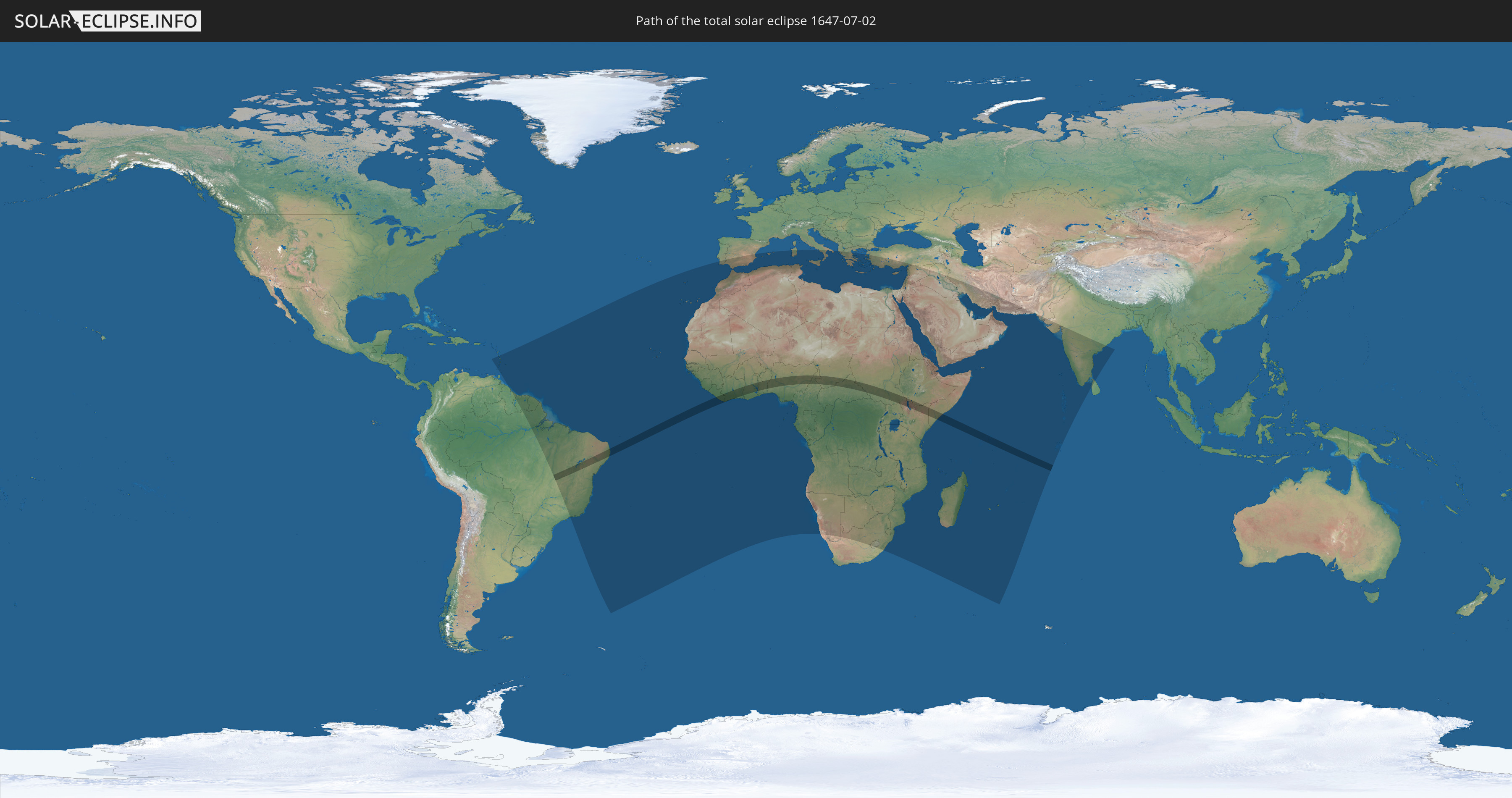
Die Sonnenfinsternis am 07/02/1647 kann man in 96 Ländern als partielle Sonnenfinsternis beobachten.
Der Finsternispfad verläuft durch 17 Länder. Nur in diesen Ländern ist sie als total Sonnenfinsternis zu sehen.
In den folgenden Ländern ist die Sonnenfinsternis total zu sehen
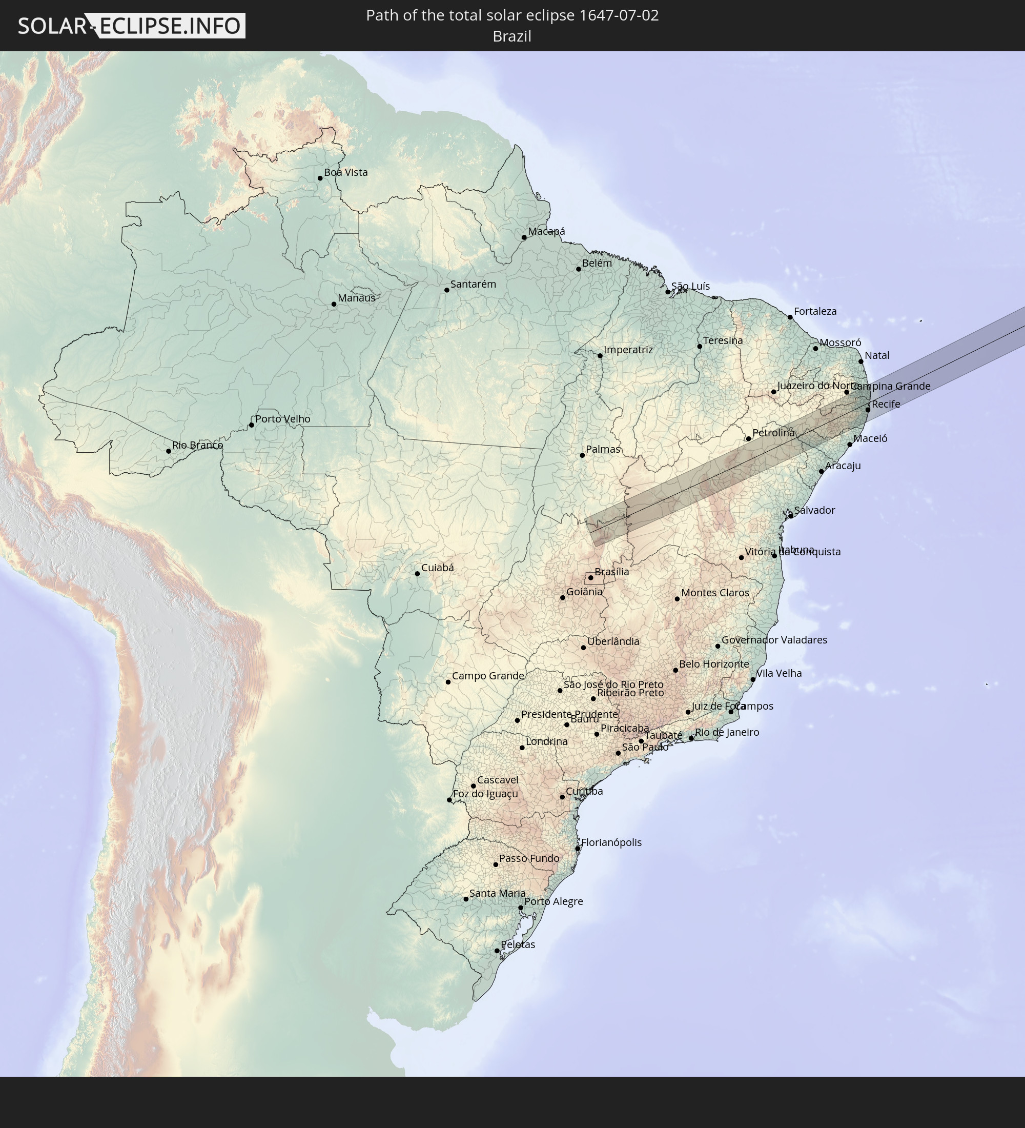 Brazil
 Liberia
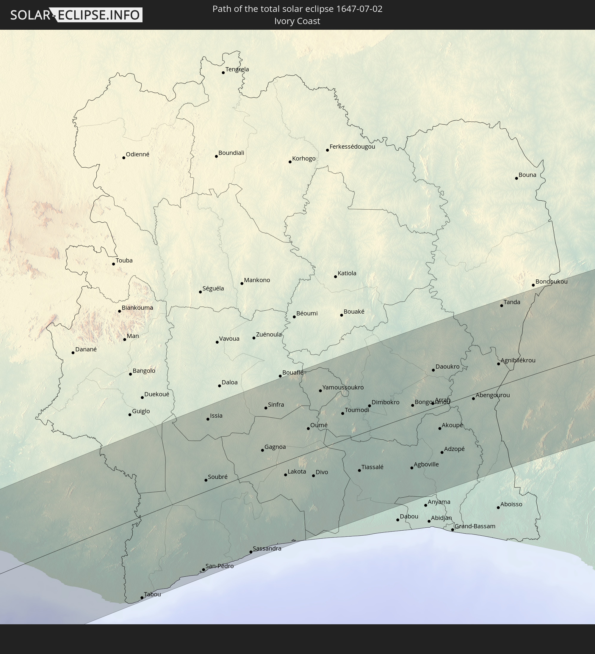 Ivory Coast
 Ghana
Ghana
 Togo
Togo
 Benin
Benin
 Nigeria
 Cameroon
 Chad
Chad
 Central African Republic
 Sudan
Sudan
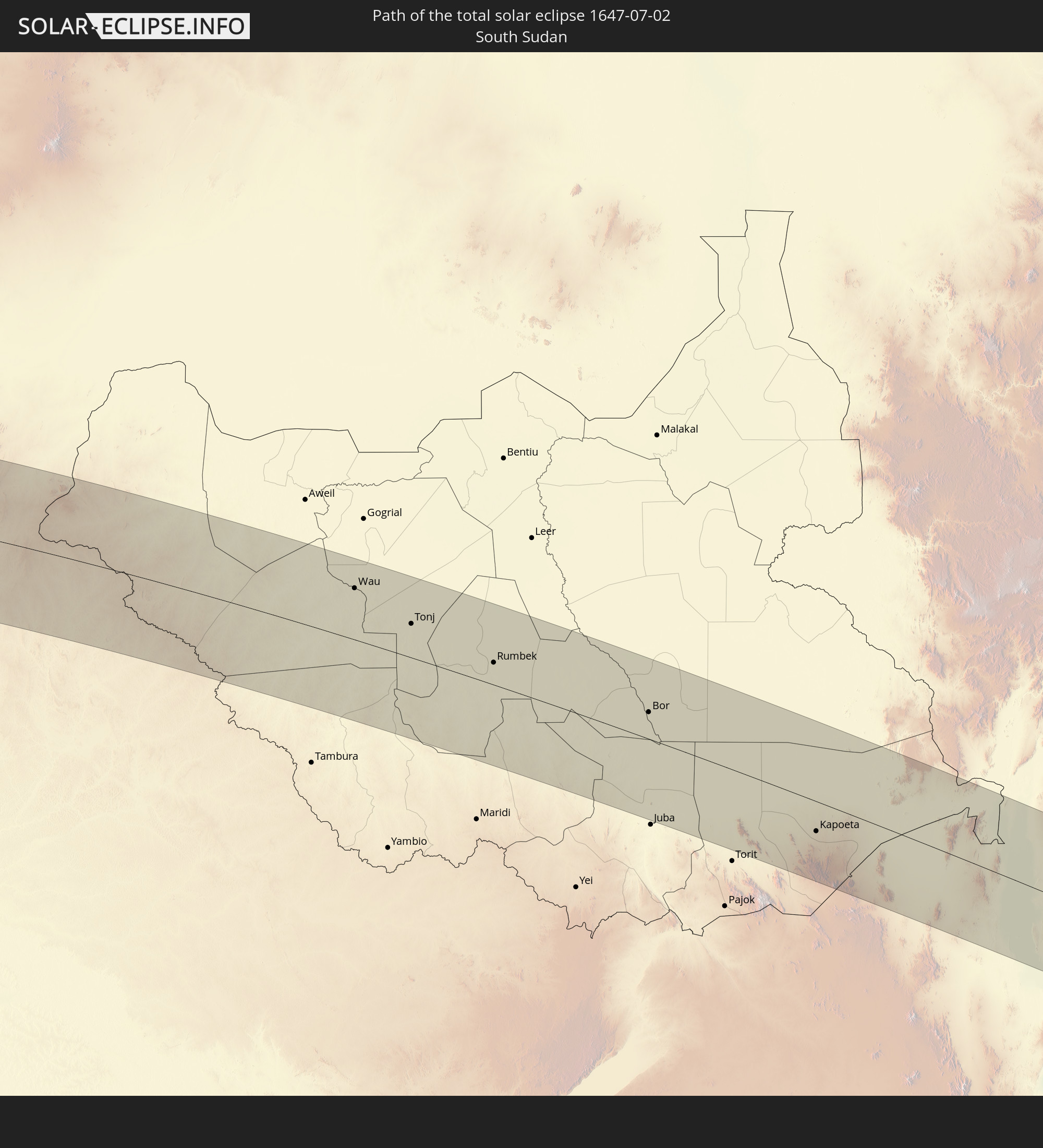 South Sudan
 Uganda
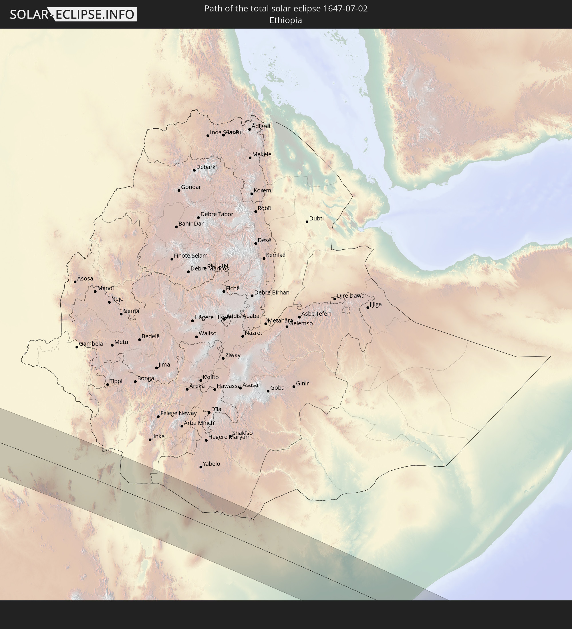 Ethiopia
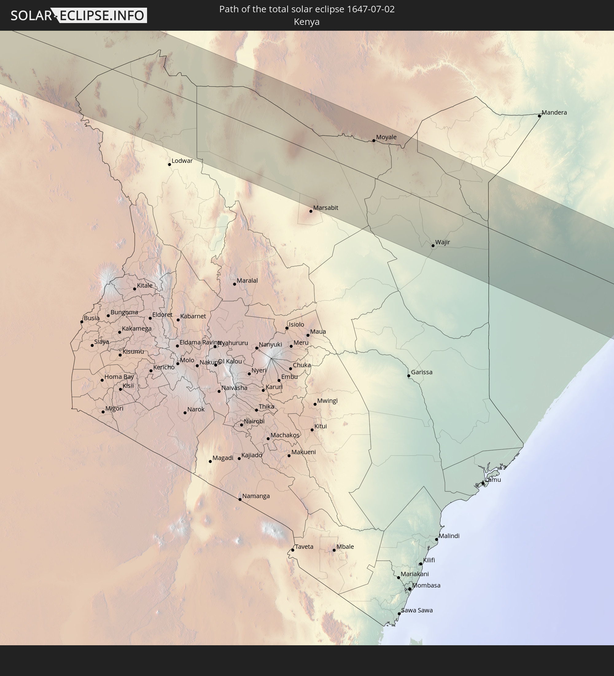 Kenya
Kenya
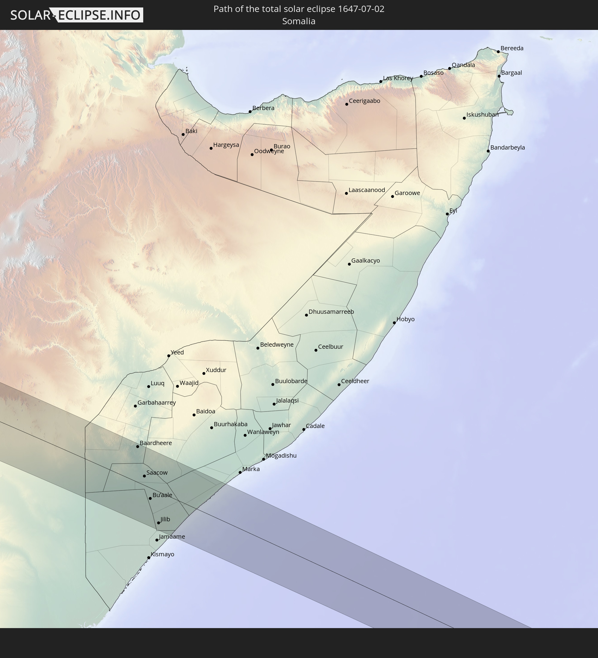 Somalia
 Seychelles
In den folgenden Ländern ist die Sonnenfinsternis partiell zu sehen
 Brazil
 Trinidad and Tobago
 Grenada
 Dominica
 Saint Vincent and the Grenadines
 Guyana
 Martinique
 Saint Lucia
 Barbados
 Suriname
 French Guiana
 Portugal
 Cabo Verde
 Spain
Spain
 Senegal
 Mauritania
 The Gambia
 Guinea-Bissau
 Guinea
 Saint Helena, Ascension and Tristan da Cunha
 Sierra Leone
 Morocco
 Mali
Mali
 Liberia
 Algeria
 Ivory Coast
 Burkina Faso
 Gibraltar
 Ghana
Ghana
 Togo
Togo
 Niger
Niger
 Benin
Benin
 Nigeria
 Equatorial Guinea
 São Tomé and Príncipe
 Italy
Italy
 Tunisia
 Cameroon
 Gabon
Gabon
 Libya
Libya
 Republic of the Congo
 Angola
 Namibia
 Democratic Republic of the Congo
 Chad
Chad
 Malta
Malta
 Central African Republic
 South Africa
 Albania
 Greece
 Botswana
 Sudan
Sudan
 Zambia
 Egypt
Egypt
 Zimbabwe
 Turkey
 Lesotho
 Rwanda
 Burundi
 Tanzania
 Uganda
 Mozambique
 Swaziland
 Cyprus
 Malawi
 Ethiopia
 Kenya
Kenya
 State of Palestine
 Israel
 Saudi Arabia
 Jordan
 Lebanon
 Syria
Syria
 Eritrea
 Iraq
Iraq
 French Southern and Antarctic Lands
 Somalia
 Djibouti
 Yemen
Yemen
 Madagascar
 Comoros
 Iran
Iran
 Mayotte
 Seychelles
 Kuwait
 Bahrain
 Qatar
Qatar
 United Arab Emirates
 Oman
Oman
 Réunion
 Mauritius
 Pakistan
 India
India
 British Indian Ocean Territory
 Maldives
 Sri Lanka
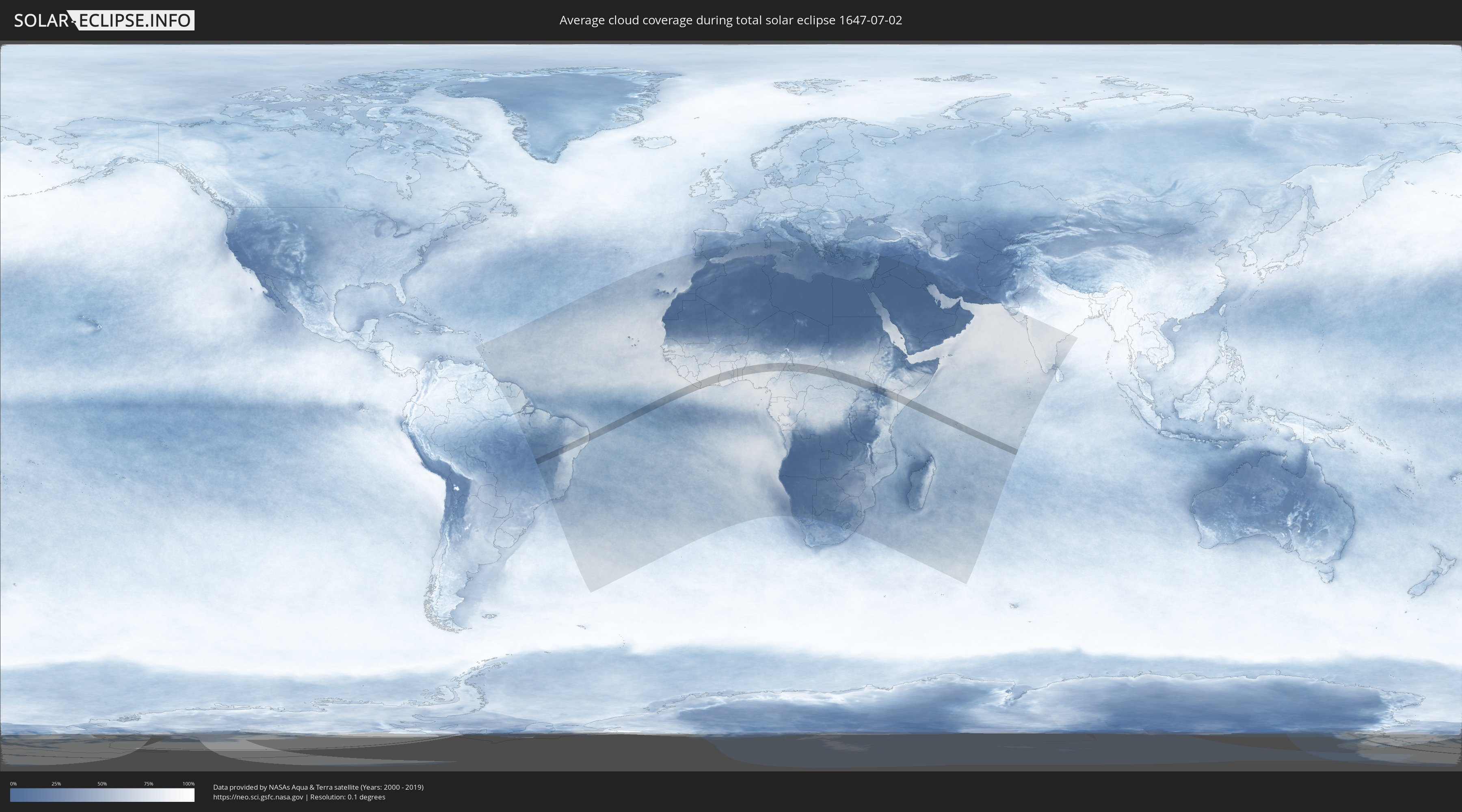
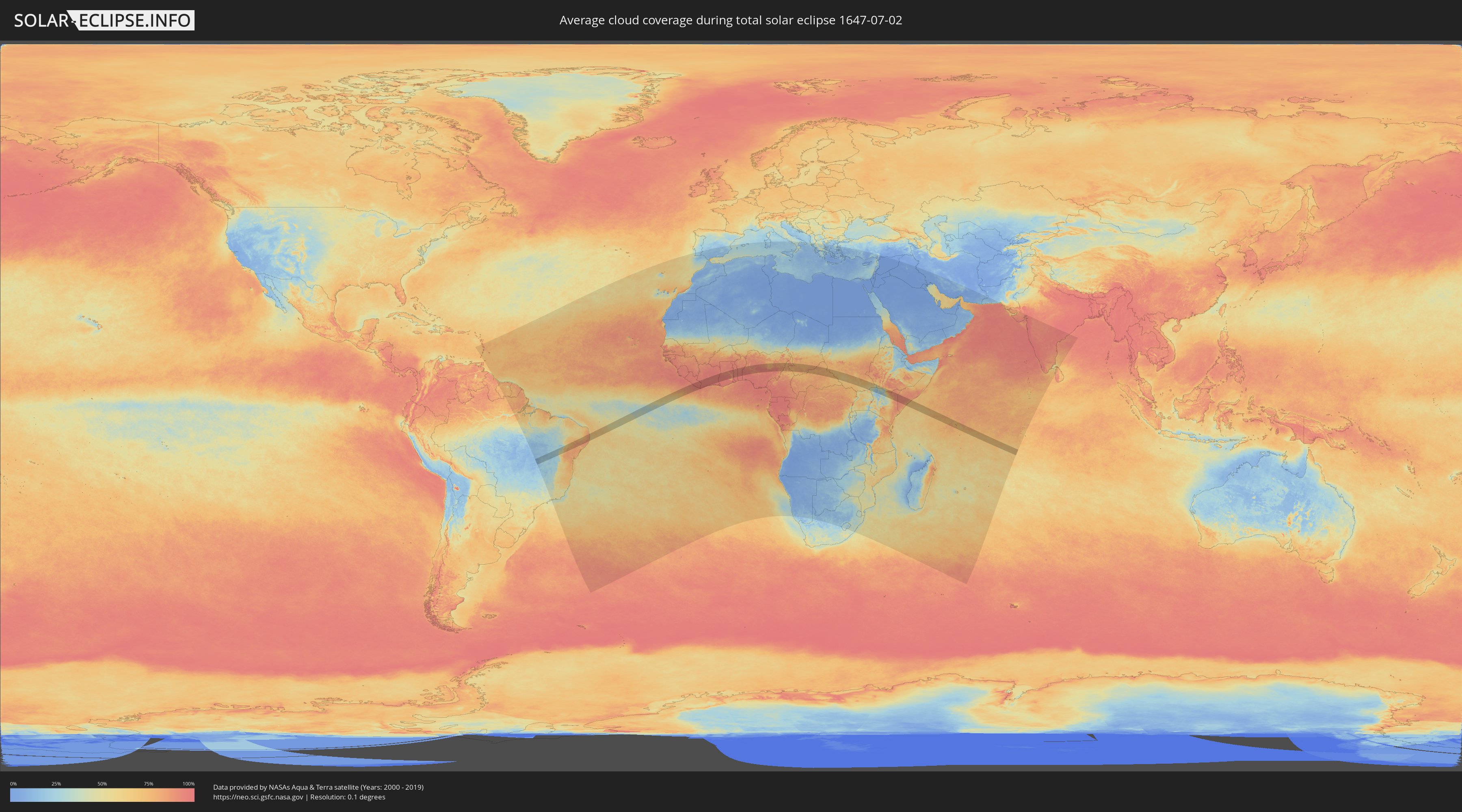
How will be the weather during the total solar eclipse on 07/02/1647?
Where is the best place to see the total solar eclipse of 07/02/1647?
The following maps show the average cloud coverage for the day of the total solar eclipse.
With the help of these maps, it is possible to find the place along the eclipse path, which has the best
chance of a cloudless sky.
Nevertheless, you should consider local circumstances and inform about the weather of your chosen
observation site.
The data is provided by NASAs satellites
AQUA and TERRA.
The cloud maps are averaged over a period of 19 years (2000 - 2019).
Detailed country maps
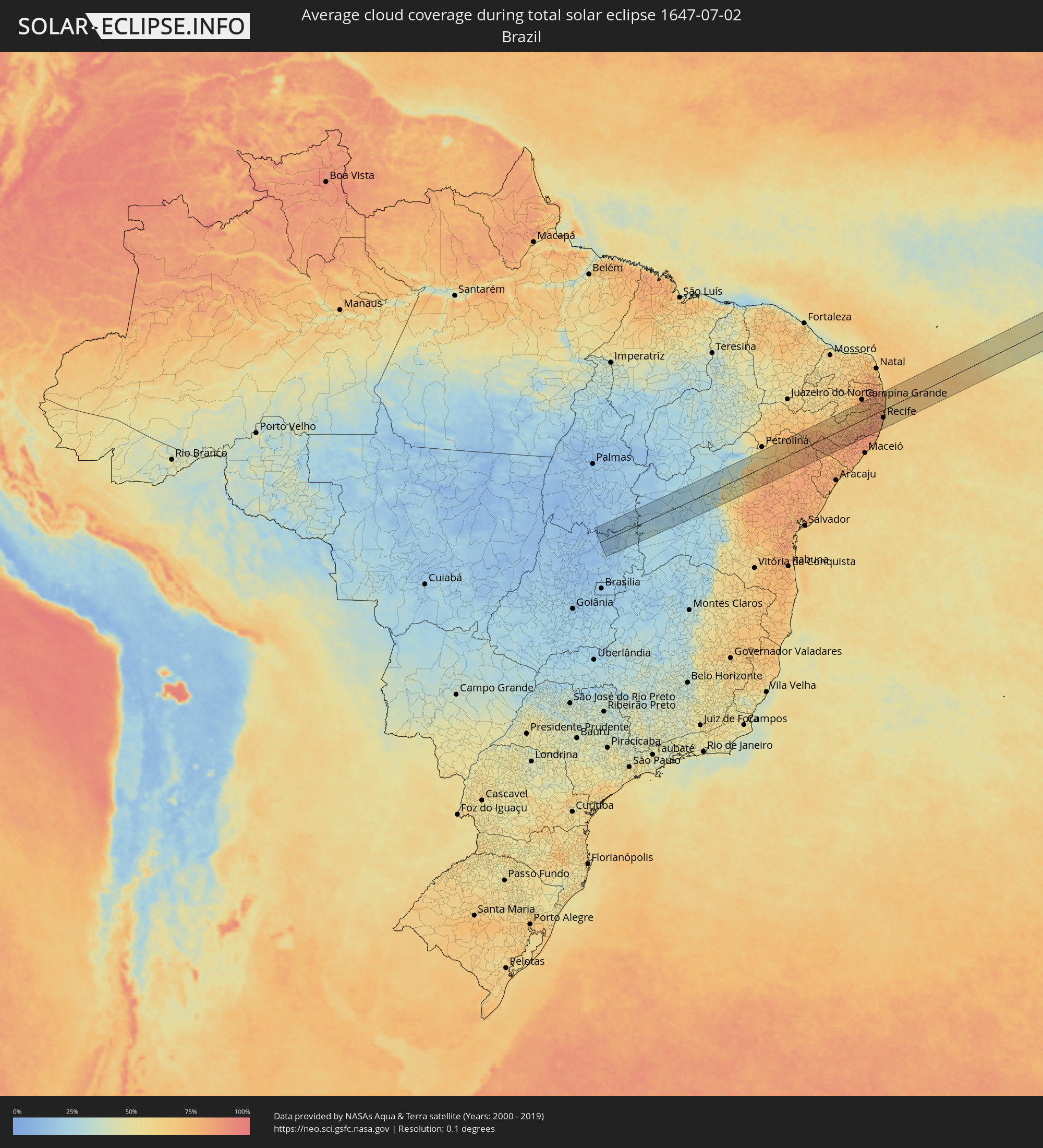 Brazil
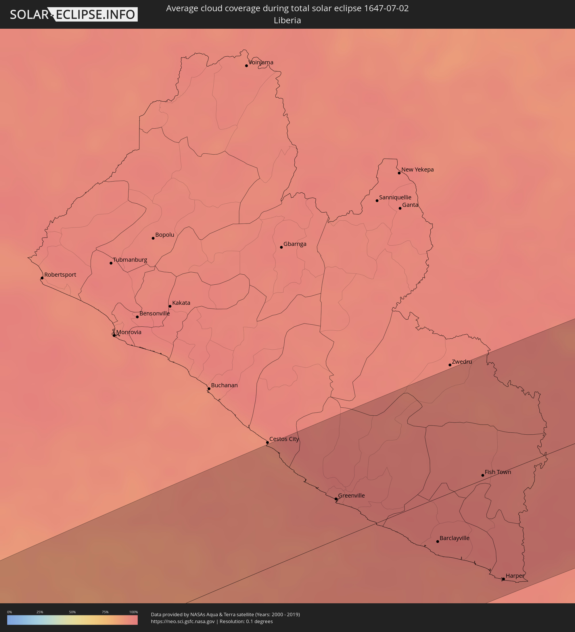 Liberia
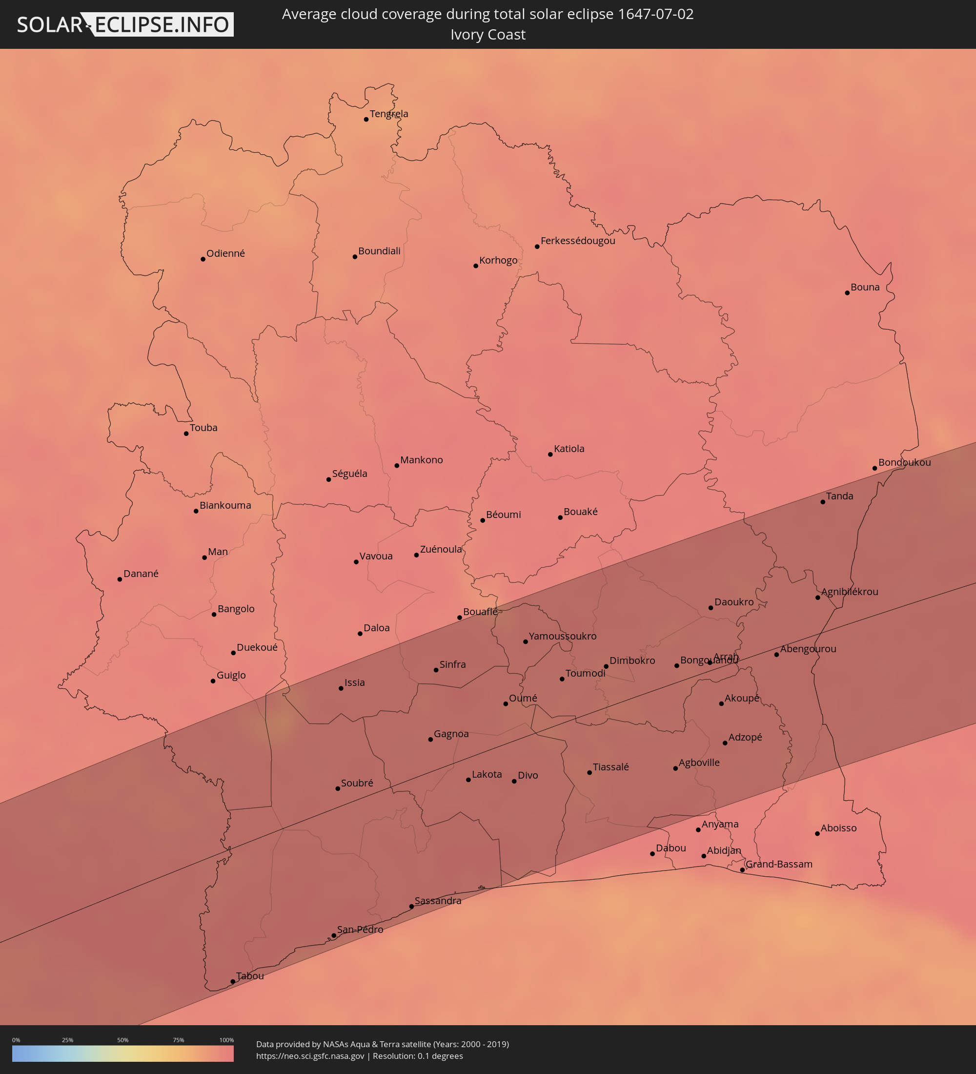 Ivory Coast
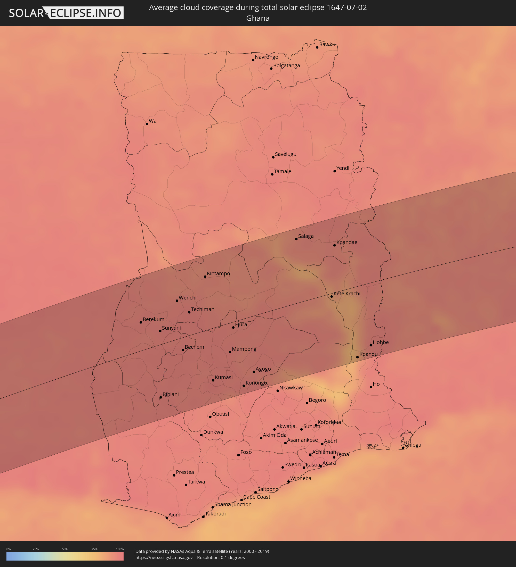 Ghana
Ghana
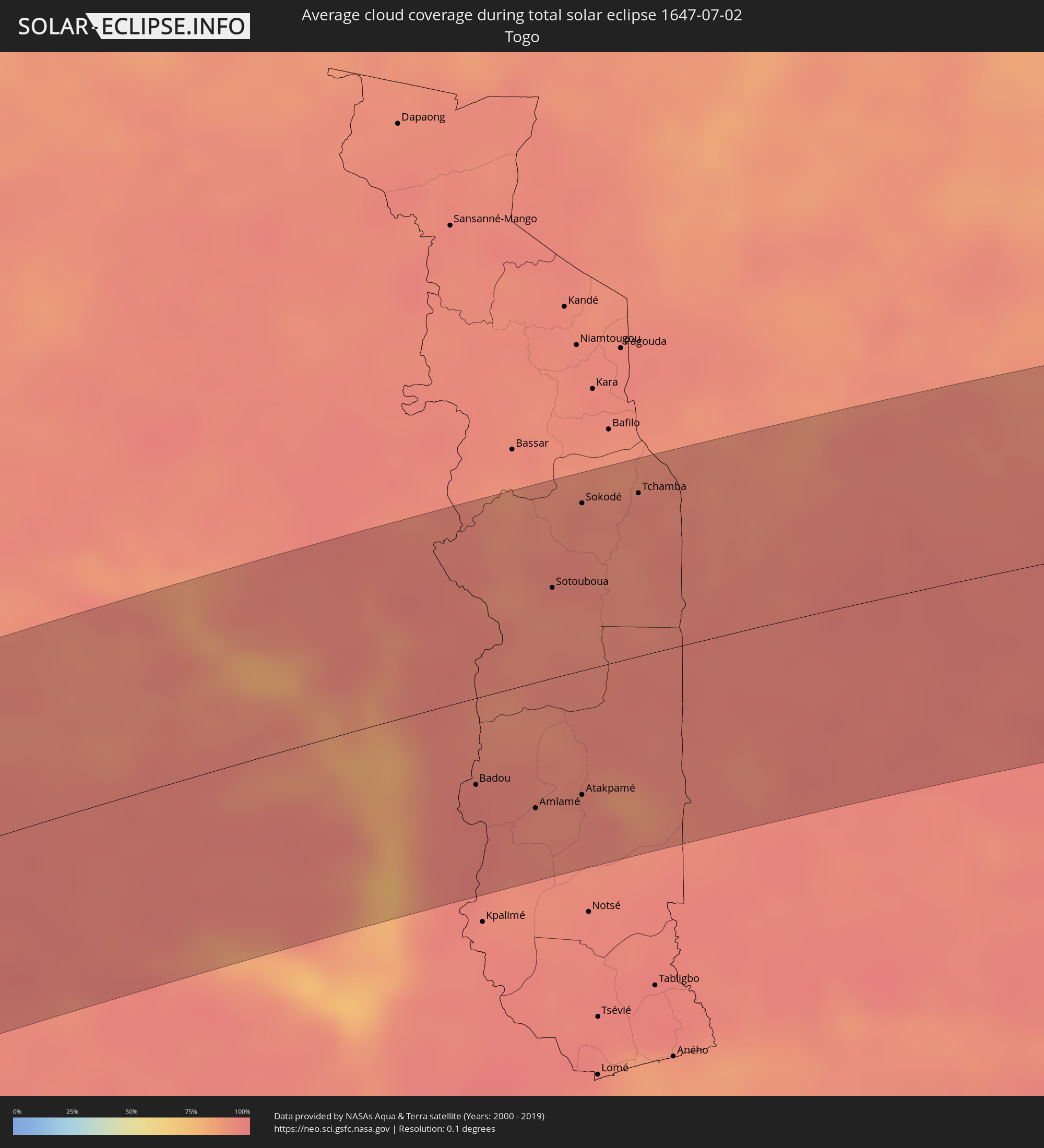 Togo
Togo
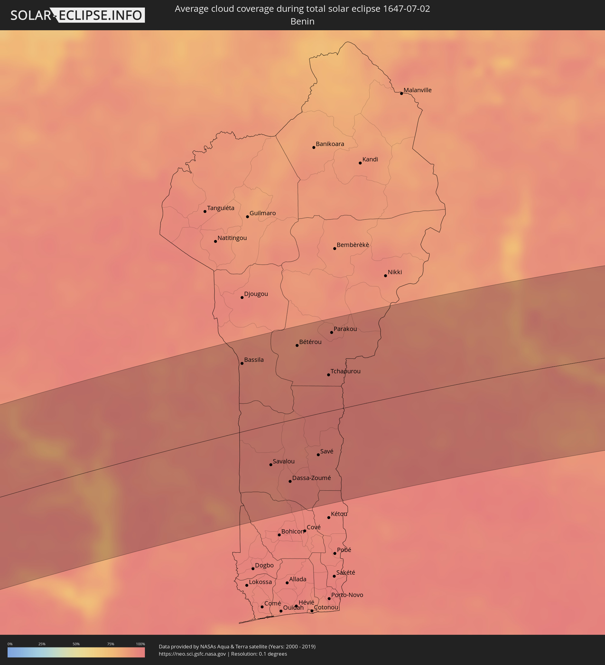 Benin
Benin
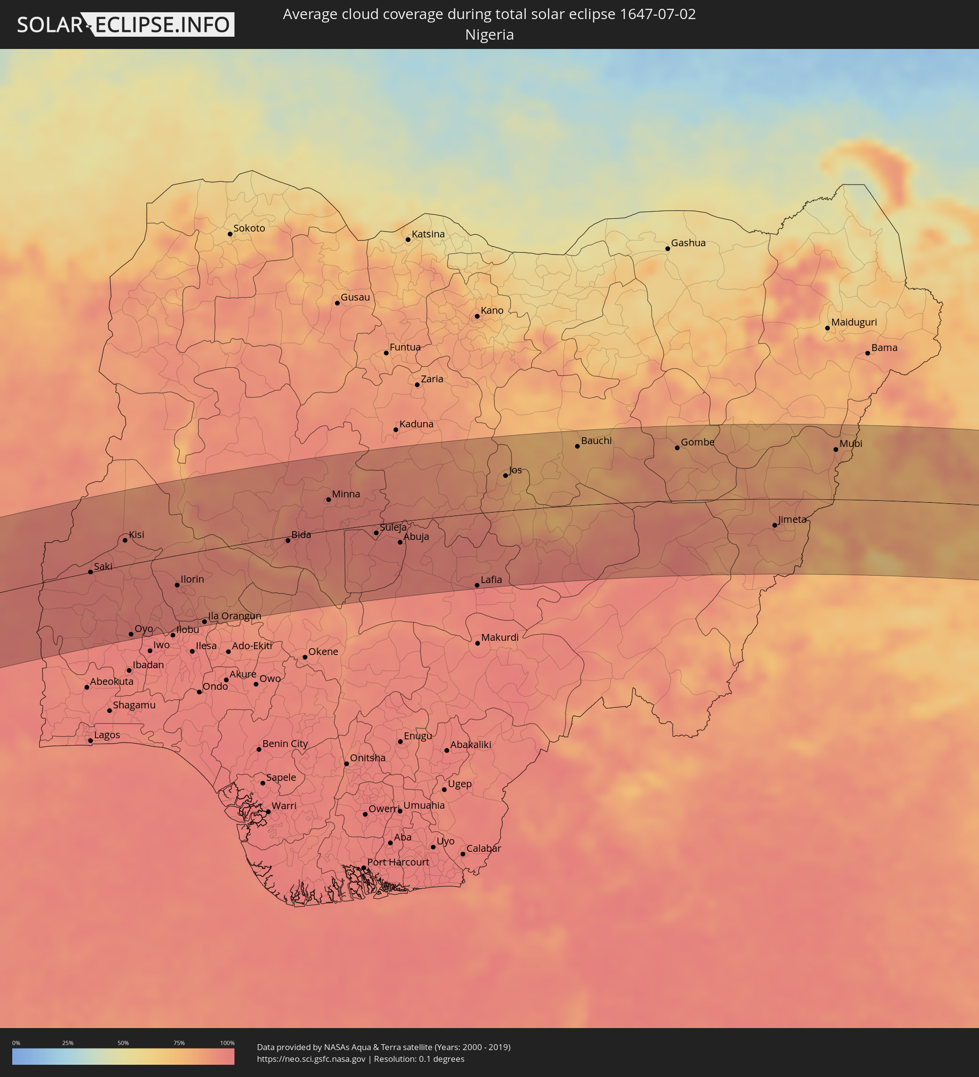 Nigeria
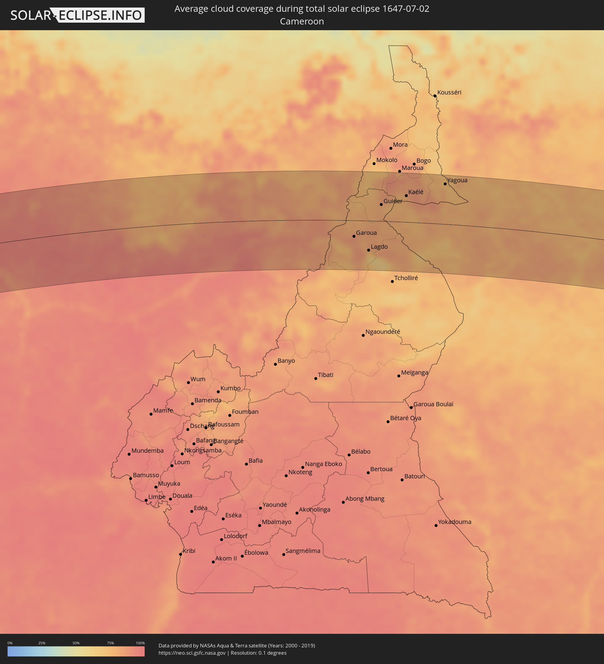 Cameroon
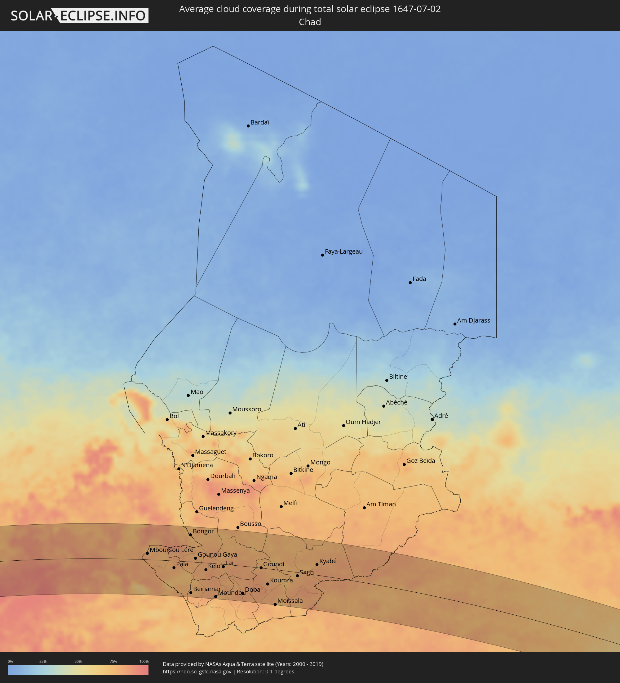 Chad
Chad
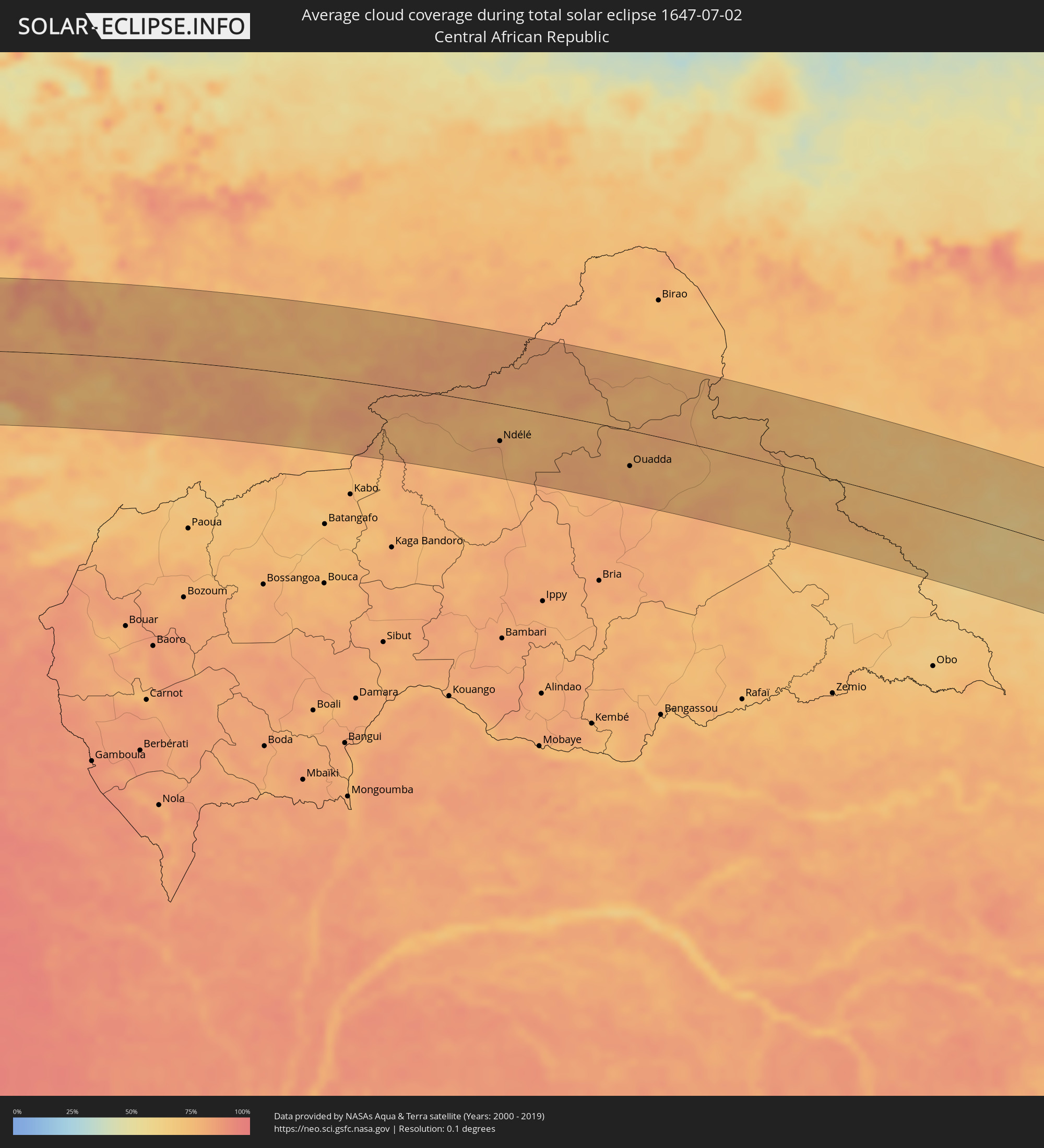 Central African Republic
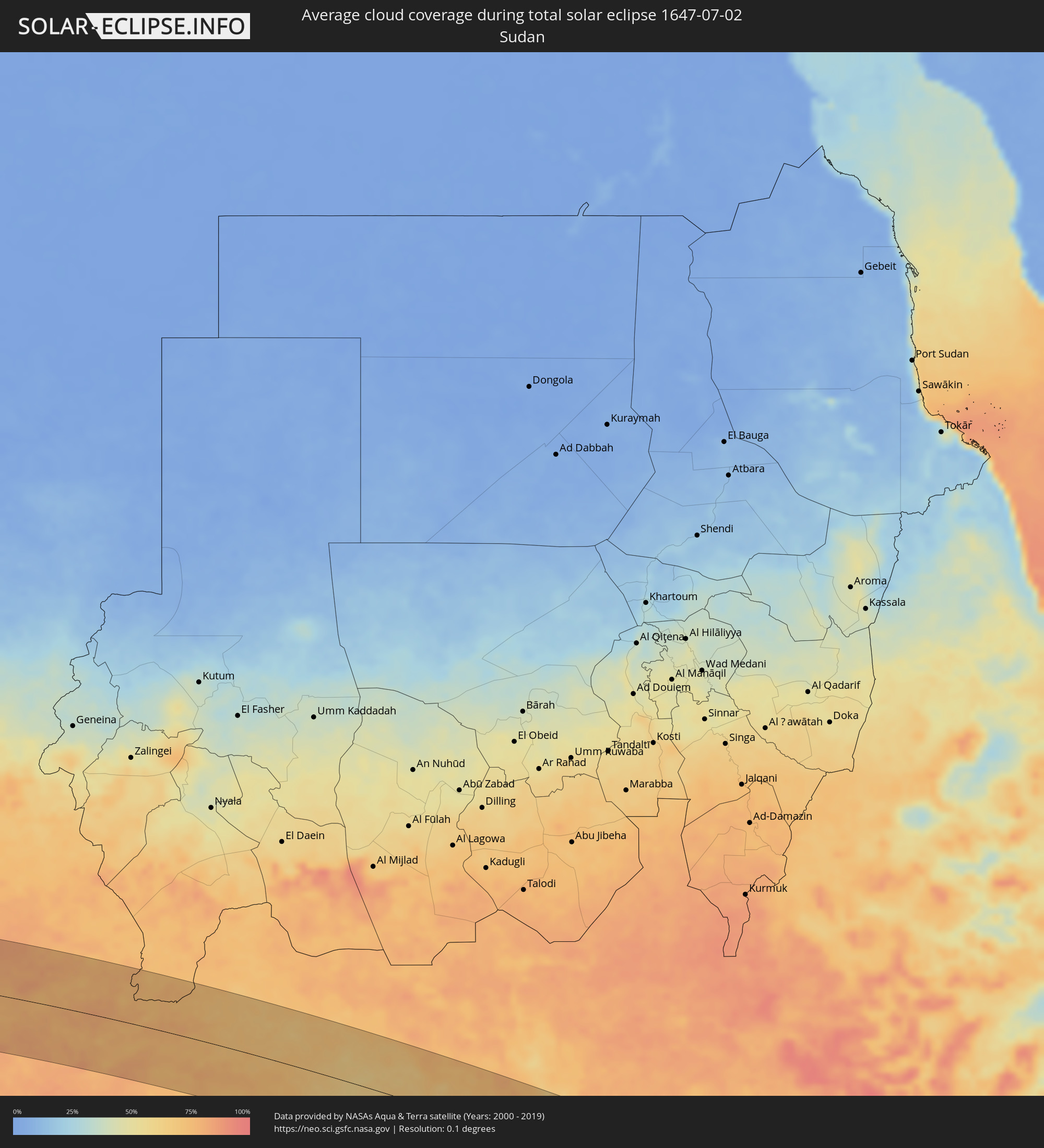 Sudan
Sudan
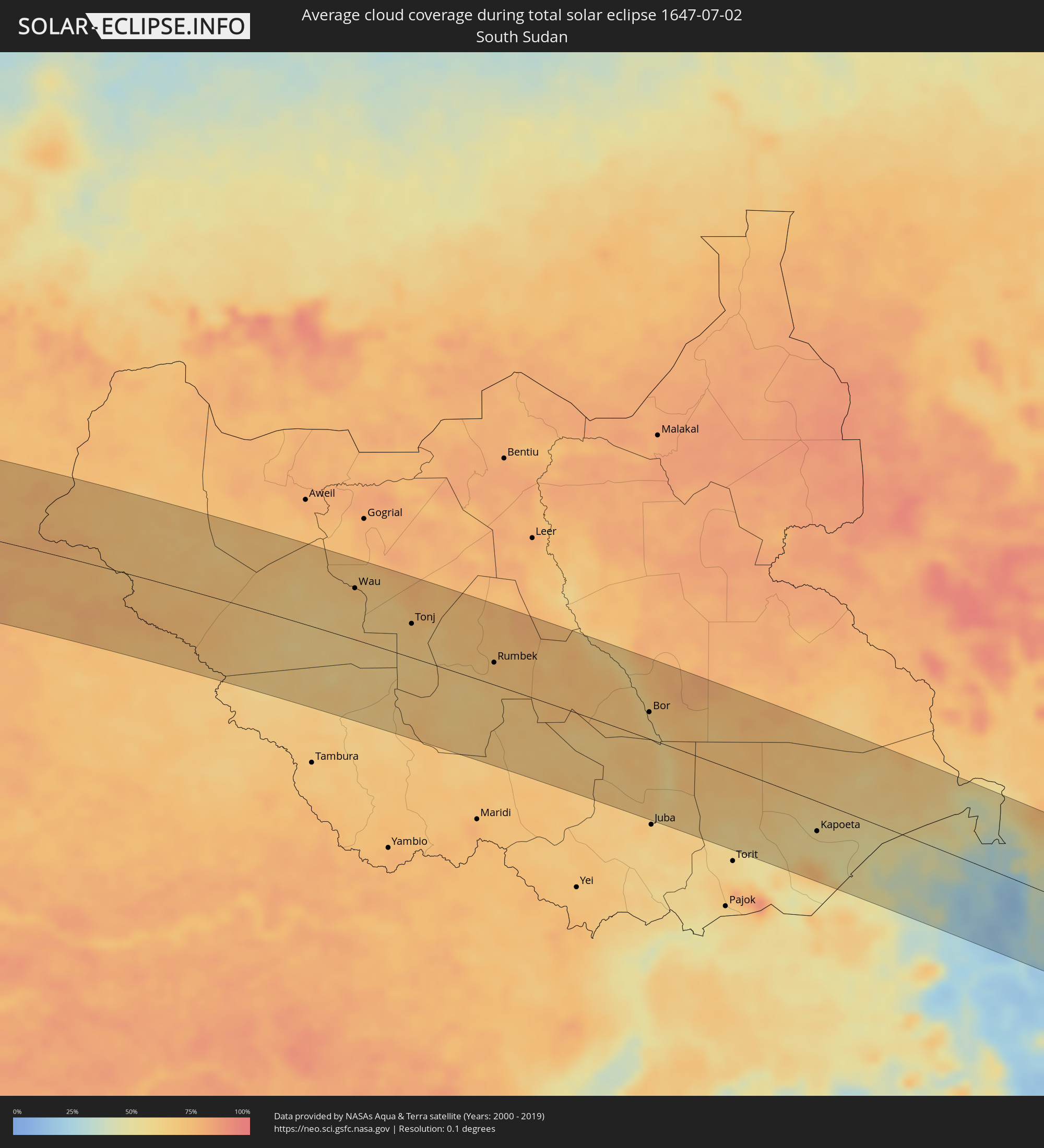 South Sudan
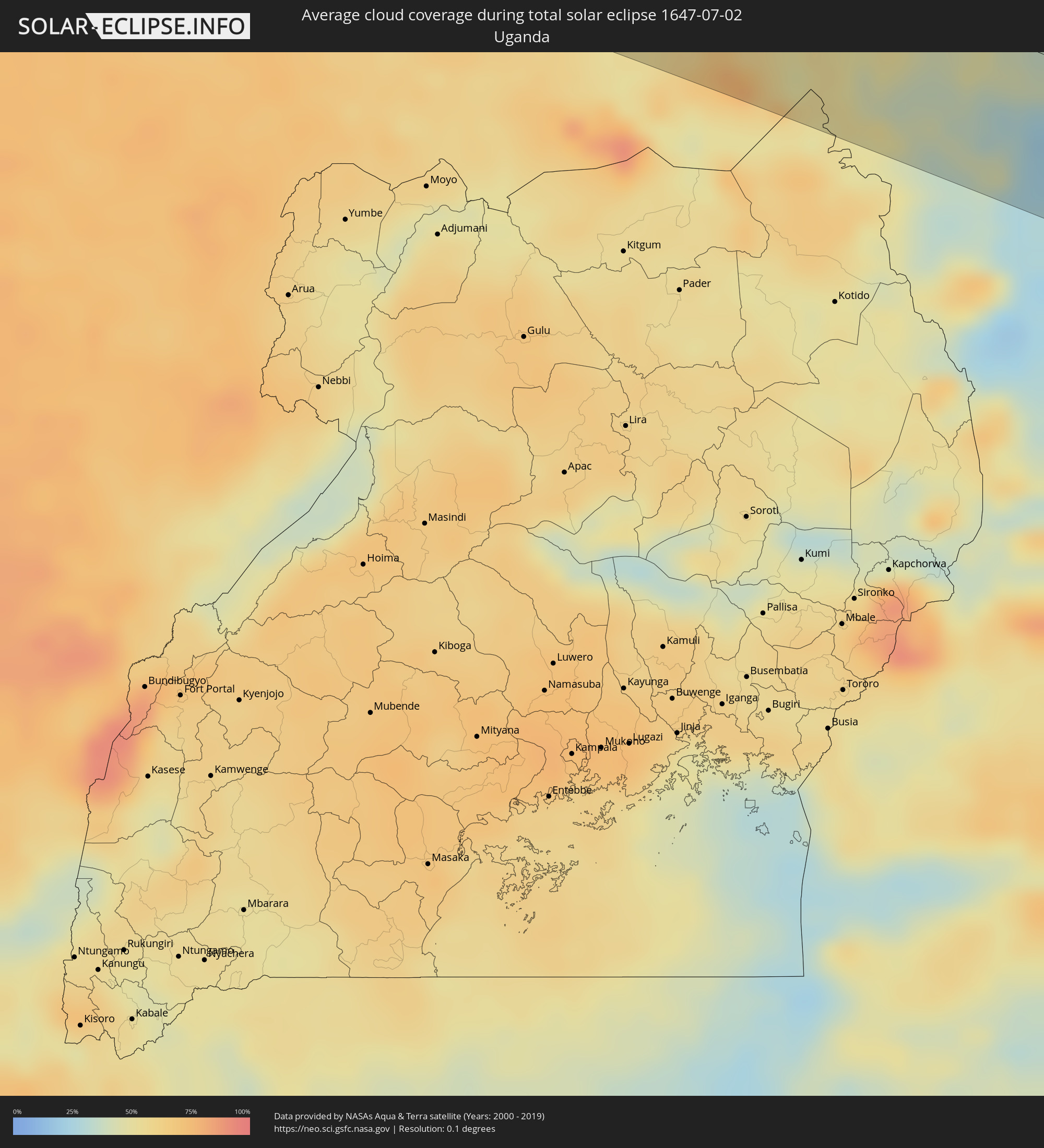 Uganda
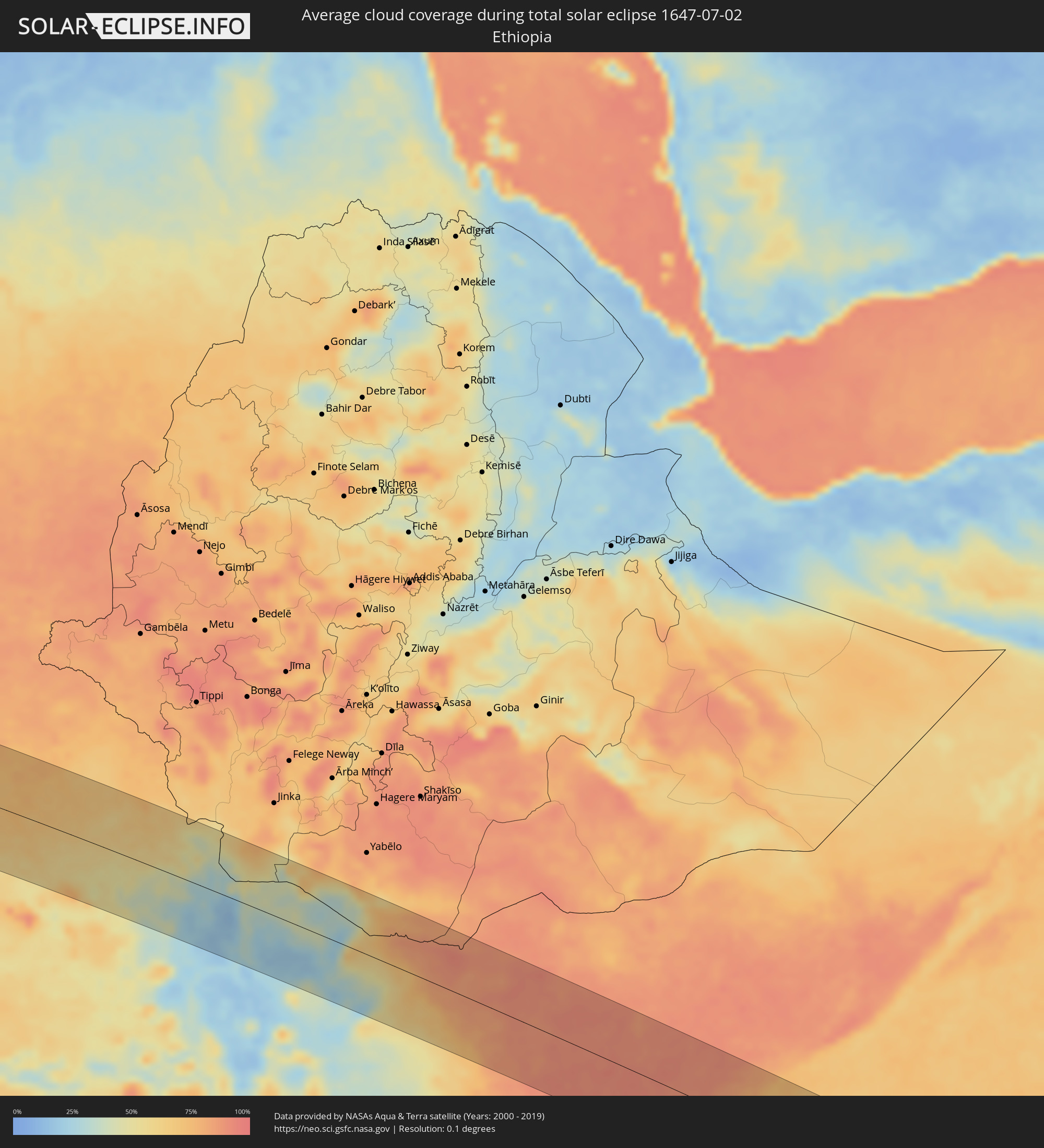 Ethiopia
 Kenya
Kenya
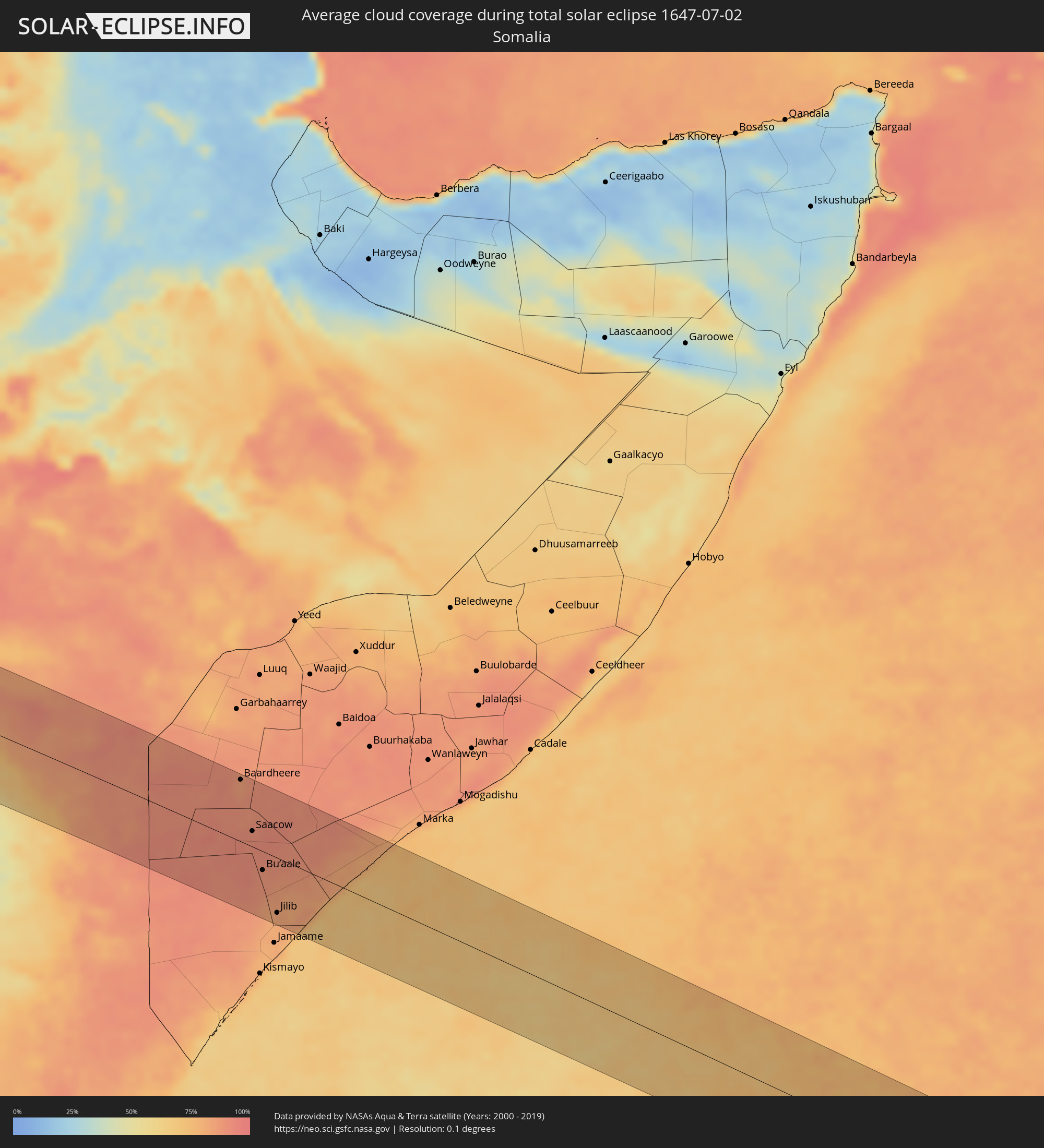 Somalia
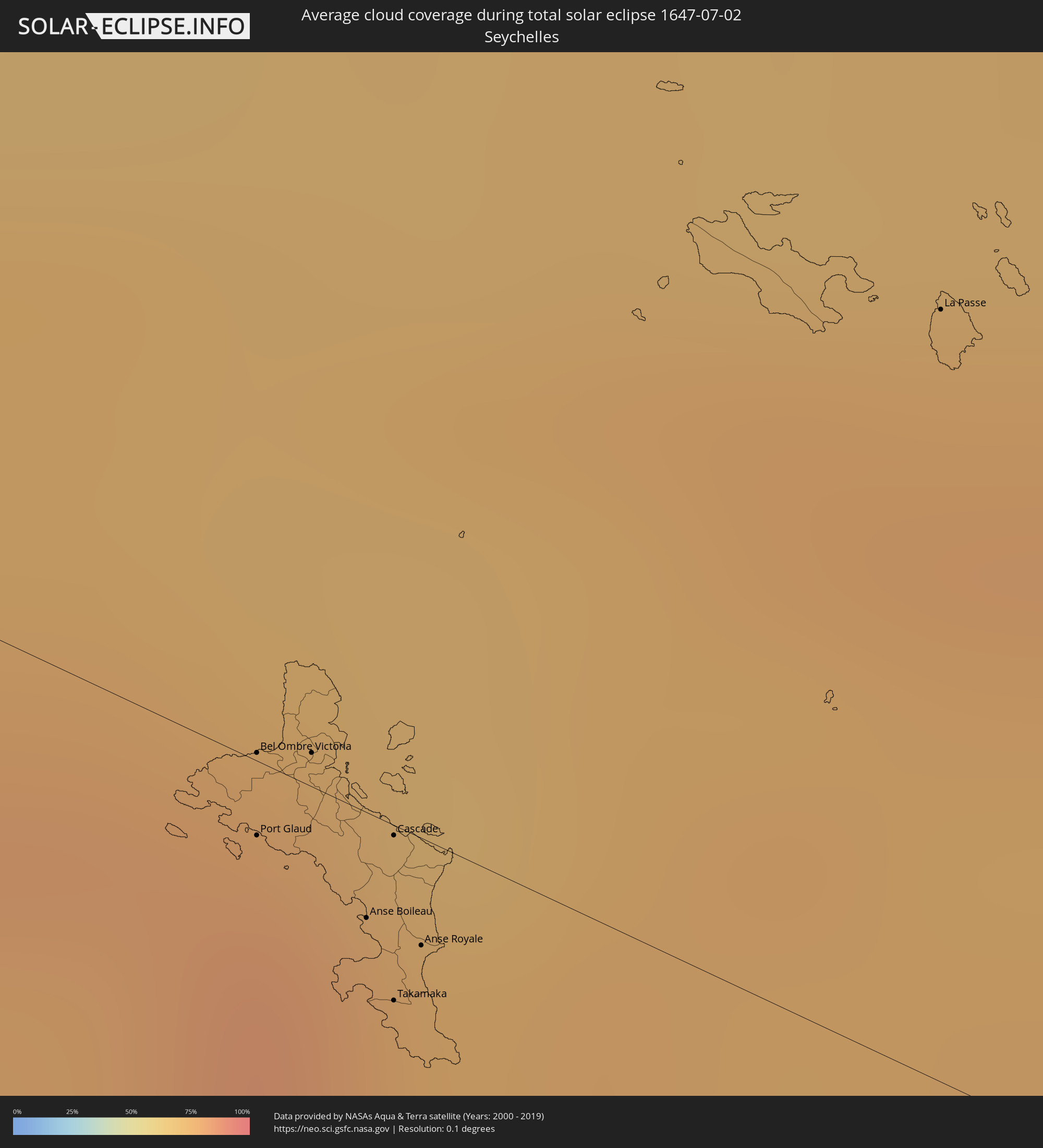 Seychelles
Cities inside the path of the eclipse
The following table shows all locations with a population of more than 5,000 inside the eclipse path. Cities which have more than 100,000 inhabitants are marked bold. A click at the locations opens a detailed map.
| City | Type | Eclipse duration | Local time of max. eclipse | Distance to central line | Ø Cloud coverage |
|
Barreiras, Bahia
|
total | - | 07:05:11 UTC-02:34 | 23 km | 25% |
|
Irecê, Bahia
|
total | - | 07:05:46 UTC-02:34 | 34 km | 47% |
|
Paulo Afonso, Bahia
|
total | - | 07:06:59 UTC-02:34 | 13 km | 82% |
|
Garanhuns, Pernambuco
|
total | - | 07:22:09 UTC-02:19 | 42 km | 85% |
|
Santa Cruz do Capibaribe, Pernambuco
|
total | - | 07:22:24 UTC-02:19 | 37 km | 75% |
|
Caruaru, Pernambuco
|
total | - | 07:22:28 UTC-02:19 | 7 km | 82% |
|
Gravatá, Pernambuco
|
total | - | 07:22:41 UTC-02:19 | 19 km | 81% |
|
Vitória de Santo Antão, Pernambuco
|
total | - | 07:22:50 UTC-02:19 | 23 km | 84% |
|
Carpina, Pernambuco
|
total | - | 07:22:53 UTC-02:19 | 2 km | 82% |
|
São Lourenço da Mata, Pernambuco
|
total | - | 07:22:59 UTC-02:19 | 25 km | 81% |
|
Jaboatão, Pernambuco
|
total | - | 07:22:58 UTC-02:19 | 44 km | 77% |
|
Igarassu, Pernambuco
|
total | - | 07:23:04 UTC-02:19 | 13 km | 75% |
|
Recife, Pernambuco
|
total | - | 07:23:03 UTC-02:19 | 37 km | 68% |
|
João Pessoa, Paraíba
|
total | - | 07:08:48 UTC-02:34 | 56 km | 78% |
|
Greenville, Sinoe
|
total | - | 09:37:54 UTC-00:43 | 33 km | 95% |
|
Barclayville, Grand Kru
|
total | - | 09:39:27 UTC-00:43 | 36 km | 97% |
|
Fish Town, River Gee
|
total | - | 09:40:36 UTC-00:43 | 3 km | 95% |
|
Harper, Maryland
|
total | - | 09:40:27 UTC-00:43 | 88 km | 95% |
|
San-Pédro, Bas-Sassandra
|
total | - | 10:10:11 UTC-00:16 | 94 km | 91% |
|
Soubré, Bas-Sassandra
|
total | - | 10:10:55 UTC-00:16 | 13 km | 94% |
|
Issia, Sassandra-Marahoué
|
total | - | 10:11:26 UTC-00:16 | 86 km | 96% |
|
Gagnoa, Gôh-Djiboua
|
total | - | 10:12:43 UTC-00:16 | 23 km | 95% |
|
Sinfra, Zanzan
|
total | - | 10:13:08 UTC-00:16 | 73 km | 95% |
|
Oumé, Gôh-Djiboua
|
total | - | 10:14:11 UTC-00:16 | 29 km | 93% |
|
Divo, Gôh-Djiboua
|
total | - | 10:13:58 UTC-00:16 | 31 km | 95% |
|
Yamoussoukro, Lacs
|
total | - | 10:14:48 UTC-00:16 | 69 km | 95% |
|
Dimbokro, Lacs
|
total | - | 10:16:07 UTC-00:16 | 30 km | 94% |
|
Agboville, Lagunes
|
total | - | 10:16:55 UTC-00:16 | 64 km | 95% |
|
Daoukro, Lacs
|
total | - | 10:18:16 UTC-00:16 | 46 km | 94% |
|
Adzopé, Lagunes
|
total | - | 10:17:55 UTC-00:16 | 58 km | 95% |
|
Abengourou, Comoé
|
total | - | 10:19:16 UTC-00:16 | 6 km | 94% |
|
Agnibilékrou, Comoé
|
total | - | 10:20:17 UTC-00:16 | 26 km | 95% |
|
Berekum, Brong-Ahafo
|
total | - | 10:37:23 UTC-00:00 | 39 km | 96% |
|
Sunyani, Brong-Ahafo
|
total | - | 10:38:00 UTC-00:00 | 19 km | 95% |
|
Wenchi, Brong-Ahafo
|
total | - | 10:38:51 UTC-00:00 | 54 km | 95% |
|
Techiman, Brong-Ahafo
|
total | - | 10:39:11 UTC-00:00 | 32 km | 96% |
|
Kintampo, Brong-Ahafo
|
total | - | 10:40:03 UTC-00:00 | 75 km | 93% |
|
Kumasi, Ashanti
|
total | - | 10:39:31 UTC-00:00 | 74 km | 96% |
|
Tafo, Ashanti
|
total | - | 10:39:35 UTC-00:00 | 69 km | 96% |
|
Mampong, Ashanti
|
total | - | 10:40:22 UTC-00:00 | 41 km | 95% |
|
Ejura, Ashanti
|
total | - | 10:40:40 UTC-00:00 | 8 km | 94% |
|
Konongo, Ashanti
|
total | - | 10:40:37 UTC-00:00 | 95 km | 95% |
|
Agogo, Ashanti
|
total | - | 10:41:06 UTC-00:00 | 80 km | 94% |
|
Salaga, Northern
|
total | - | 10:43:41 UTC-00:00 | 90 km | 93% |
|
Kpandu, Volta
|
total | - | 10:45:07 UTC-00:00 | 101 km | 89% |
|
Hohoe, Volta
|
total | - | 10:45:44 UTC-00:00 | 89 km | 95% |
|
Badou, Plateaux
|
total | - | 10:31:04 UTC-00:16 | 46 km | 96% |
|
Amlamé, Plateaux
|
total | - | 10:31:52 UTC-00:16 | 67 km | 92% |
|
Sotouboua, Centrale
|
total | - | 10:32:42 UTC-00:16 | 48 km | 92% |
|
Sokodé, Centrale
|
total | - | 10:33:22 UTC-00:16 | 90 km | 93% |
|
Atakpamé, Plateaux
|
total | - | 10:32:35 UTC-00:16 | 67 km | 91% |
|
Tchamba, Centrale
|
total | - | 10:34:13 UTC-00:16 | 88 km | 92% |
|
Bassila, Donga
|
total | - | 11:04:38 UTC+00:13 | 78 km | 93% |
|
Savalou, Collines
|
total | - | 11:05:00 UTC+00:13 | 47 km | 92% |
|
Dassa-Zoumé, Collines
|
total | - | 11:05:32 UTC+00:13 | 71 km | 95% |
|
Bétérou, Borgou
|
total | - | 11:06:29 UTC+00:13 | 84 km | 91% |
|
Savé, Collines
|
total | - | 11:06:36 UTC+00:13 | 48 km | 95% |
|
Tchaourou, Borgou
|
total | - | 11:07:20 UTC+00:13 | 42 km | 95% |
|
Parakou, Borgou
|
total | - | 11:07:39 UTC+00:13 | 90 km | 94% |
|
Saki, Oyo
|
total | - | 11:09:39 UTC+00:13 | 1 km | 95% |
|
Kisi, Oyo
|
total | - | 11:11:14 UTC+00:13 | 35 km | 92% |
|
Oyo, Oyo
|
total | - | 11:10:56 UTC+00:13 | 101 km | 96% |
|
Ilorin, Kwara
|
total | - | 11:13:07 UTC+00:13 | 44 km | 94% |
|
Ila Orangun, Osun
|
total | - | 11:14:03 UTC+00:13 | 103 km | 93% |
|
Bida, Niger
|
total | - | 11:17:57 UTC+00:13 | 6 km | 95% |
|
Minna, Niger
|
total | - | 11:19:50 UTC+00:13 | 44 km | 95% |
|
Suleja, Niger
|
total | - | 11:21:42 UTC+00:13 | 13 km | 95% |
|
Abuja, Abuja Federal Capital Territory
|
total | - | 11:22:41 UTC+00:13 | 31 km | 97% |
|
Jos, Plateau
|
total | - | 11:27:24 UTC+00:13 | 50 km | 82% |
|
Bauchi, Bauchi
|
total | - | 11:30:32 UTC+00:13 | 85 km | 78% |
|
Gombe, Gombe
|
total | - | 11:34:48 UTC+00:13 | 76 km | 81% |
|
Jimeta, Adamawa
|
total | - | 11:38:54 UTC+00:13 | 39 km | 85% |
|
Mubi, Adamawa
|
total | - | 11:41:33 UTC+00:13 | 72 km | 83% |
|
Garoua, North
|
total | - | 11:41:59 UTC+00:13 | 36 km | 83% |
|
Pitoa, North
|
total | - | 11:42:19 UTC+00:13 | 26 km | 82% |
|
Lagdo, North
|
total | - | 11:42:56 UTC+00:13 | 66 km | 67% |
|
Guider, North
|
total | - | 11:43:45 UTC+00:13 | 36 km | 81% |
|
Mboursou Léré, Mayo-Kebbi Ouest
|
total | - | 12:31:02 UTC+01:00 | 18 km | 81% |
|
Rey Bouba, North
|
total | - | 11:44:32 UTC+00:13 | 103 km | 78% |
|
Mindif, Far North
|
total | - | 11:45:17 UTC+00:13 | 90 km | 83% |
|
Kaélé, Far North
|
total | - | 11:45:21 UTC+00:13 | 58 km | 81% |
|
Pala, Mayo-Kebbi Ouest
|
total | - | 12:33:29 UTC+01:00 | 23 km | 78% |
|
Yagoua, Far North
|
total | - | 11:47:49 UTC+00:13 | 88 km | 81% |
|
Bongor, Mayo-Kebbi Est
|
total | - | 12:34:53 UTC+01:00 | 82 km | 74% |
|
Kelo, Tandjilé
|
total | - | 12:36:23 UTC+01:00 | 22 km | 82% |
|
Moundou, Logone Occidental
|
total | - | 12:37:21 UTC+01:00 | 102 km | 72% |
|
Béré, Tandjilé
|
total | - | 12:37:29 UTC+01:00 | 18 km | 81% |
|
Laï, Tandjilé
|
total | - | 12:37:56 UTC+01:00 | 8 km | 77% |
|
Benoy, Logone Occidental
|
total | - | 12:38:04 UTC+01:00 | 54 km | 79% |
|
Bébédja, Logone Oriental
|
total | - | 12:38:53 UTC+01:00 | 85 km | 81% |
|
Doba, Logone Oriental
|
total | - | 12:39:48 UTC+01:00 | 85 km | 82% |
|
Goundi, Mandoul
|
total | - | 12:41:18 UTC+01:00 | 1 km | 79% |
|
Koumra, Mandoul
|
total | - | 12:41:59 UTC+01:00 | 48 km | 82% |
|
Sagh, Moyen-Chari
|
total | - | 12:44:33 UTC+01:00 | 11 km | 80% |
|
Kyabé, Moyen-Chari
|
total | - | 12:46:10 UTC+01:00 | 31 km | 81% |
|
Ndélé, Bamingui-Bangoran
|
total | - | 12:05:00 UTC+00:13 | 53 km | 81% |
|
Ouadda, Haute-Kotto
|
total | - | 12:10:16 UTC+00:13 | 52 km | 76% |
 Wau, Western Bahr al Ghazal
|
total | - | 14:18:15 UTC+02:06 | 66 km | 70% |
|
Tonj, Warrap
|
total | - | 14:20:09 UTC+02:06 | 43 km | 71% |
|
Rumbek, Lakes
|
total | - | 14:22:45 UTC+02:06 | 28 km | 72% |
|
Bor, Jonglei
|
total | - | 14:27:19 UTC+02:06 | 34 km | 66% |
|
Kapoeta, Eastern Equatoria
|
total | - | 14:32:21 UTC+02:06 | 37 km | 58% |
|
Mēga, Oromiya
|
total | - | 15:02:13 UTC+02:27 | 85 km | 72% |
|
Moyale, Marsabit
|
total | - | 15:03:43 UTC+02:27 | 63 km | 89% |
|
Wajir, Wajir
|
total | - | 15:06:08 UTC+02:27 | 73 km | 87% |
|
Baardheere, Gedo
|
total | - | 15:09:07 UTC+02:27 | 88 km | 85% |
|
Saacow, Middle Juba
|
total | - | 15:09:40 UTC+02:27 | 22 km | 91% |
|
Bu’aale, Middle Juba
|
total | - | 15:10:05 UTC+02:27 | 27 km | 88% |
|
Jilib, Middle Juba
|
total | - | 15:10:36 UTC+02:27 | 78 km | 82% |
|
Port Glaud, Port Glaud
|
total | - | 16:38:49 UTC+03:41 | 5 km | 78% |
|
Bel Ombre, Bel Ombre
|
total | - | 16:38:48 UTC+03:41 | 1 km | 83% |
|
Beau Vallon, Beau Vallon
|
total | - | 16:38:49 UTC+03:41 | 1 km | 83% |
|
Victoria, English River
|
total | - | 16:38:50 UTC+03:41 | 2 km | 74% |
|
Anse Boileau, Anse Boileau
|
total | - | 16:38:52 UTC+03:41 | 6 km | 80% |
|
Takamaka, Takamaka
|
total | - | 16:38:53 UTC+03:41 | 11 km | 77% |
|
Cascade, Cascade
|
total | - | 16:38:52 UTC+03:41 | 1 km | 80% |
|
Anse Royale, Anse Royale
|
total | - | 16:38:53 UTC+03:41 | 7 km | 80% |
|
La Passe, Inner Islands
|
total | - | 16:39:01 UTC+03:41 | 47 km | 78% |