Annular solar eclipse of 11/05/1687
| Day of week: | Wednesday |
| Maximum duration of eclipse: | 04m49s |
| Maximum width of eclipse path: | 160 km |
| Saros cycle: | 128 |
| Coverage: | 95.6% |
| Magnitude: | 0.9561 |
| Gamma: | -0.046 |
Wo kann man die Sonnenfinsternis vom 11/05/1687 sehen?
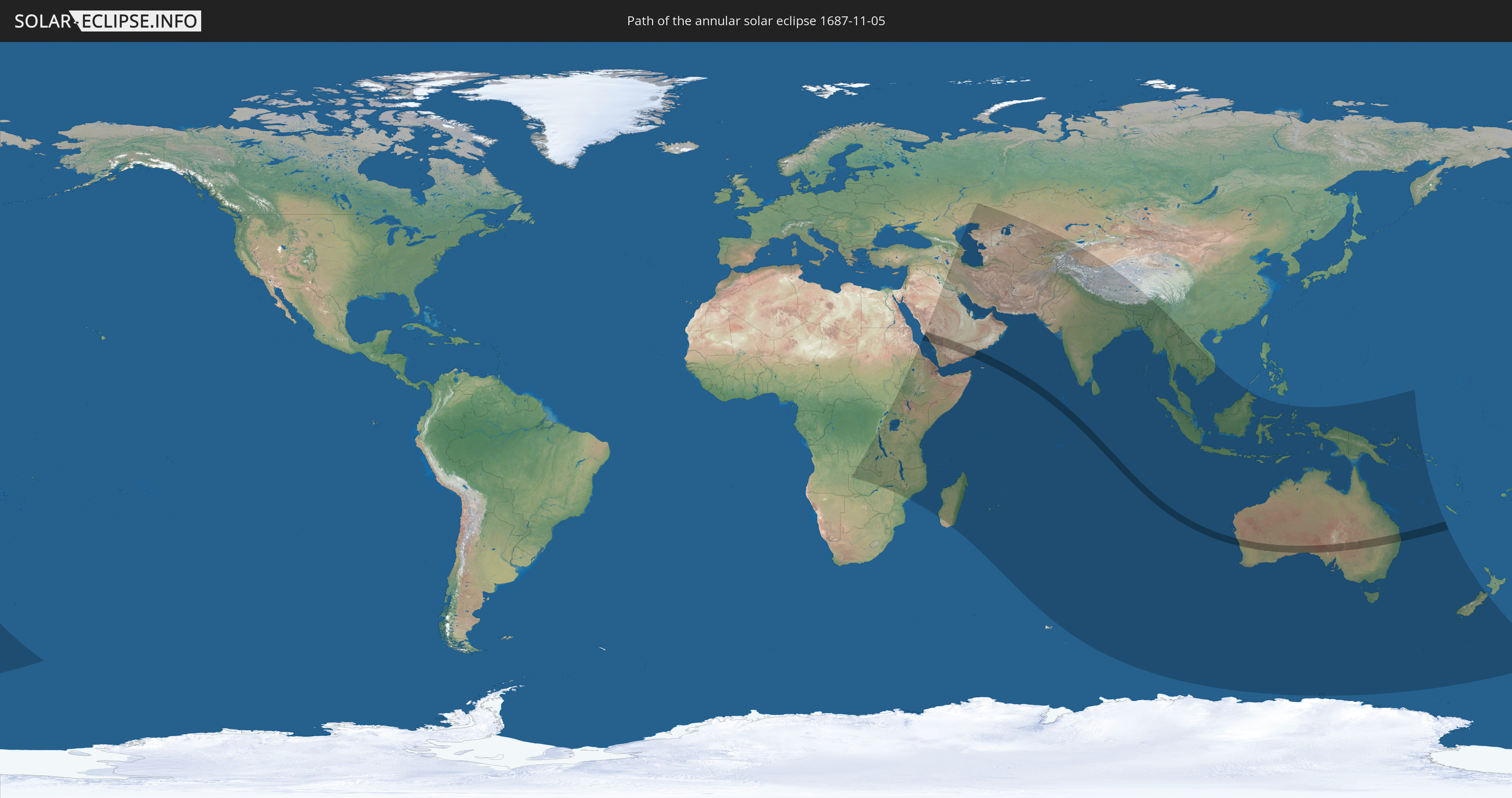
Die Sonnenfinsternis am 11/05/1687 kann man in 68 Ländern als partielle Sonnenfinsternis beobachten.
Der Finsternispfad verläuft durch 4 Länder. Nur in diesen Ländern ist sie als annular Sonnenfinsternis zu sehen.
In den folgenden Ländern ist die Sonnenfinsternis annular zu sehen
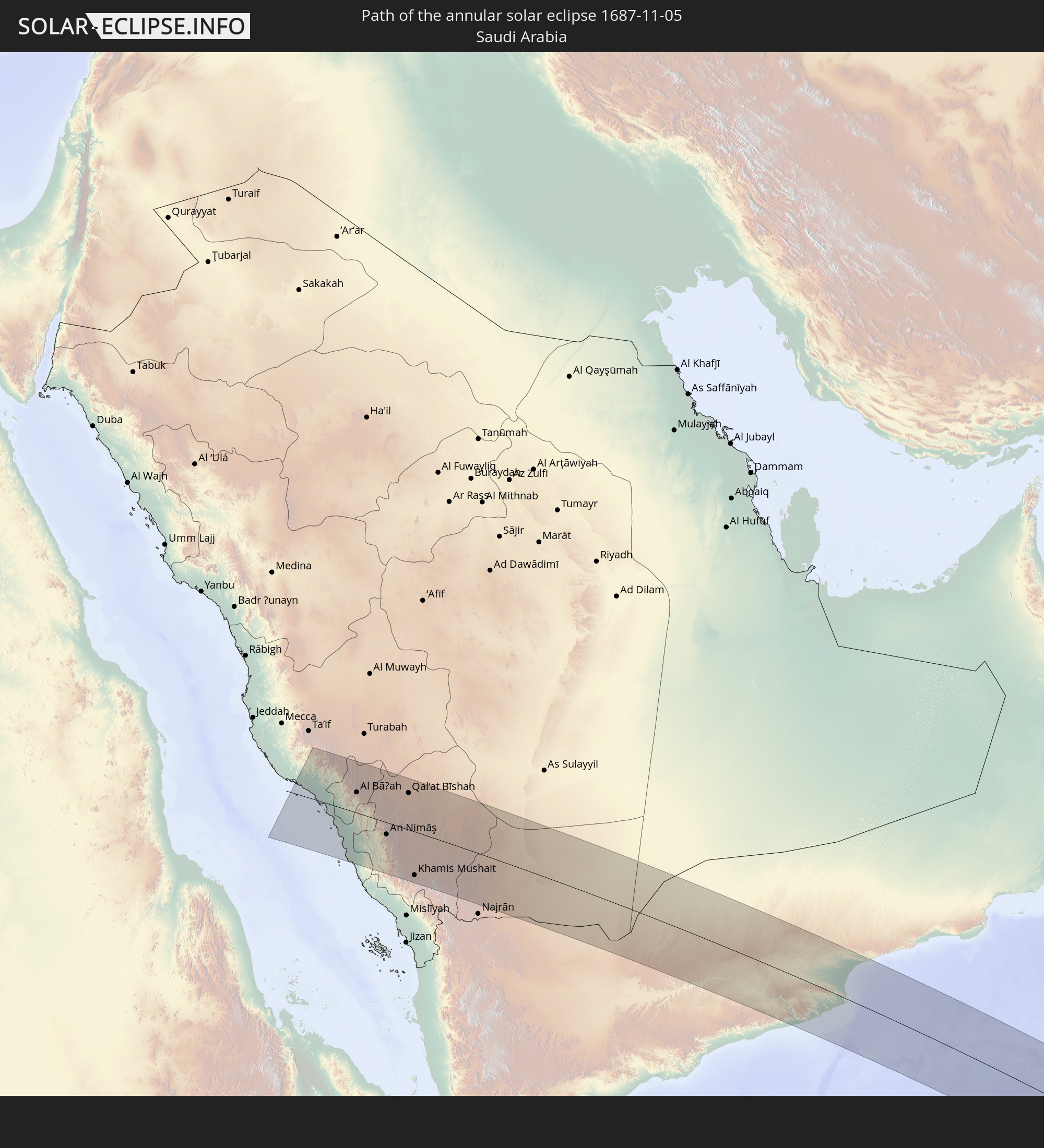 Saudi Arabia
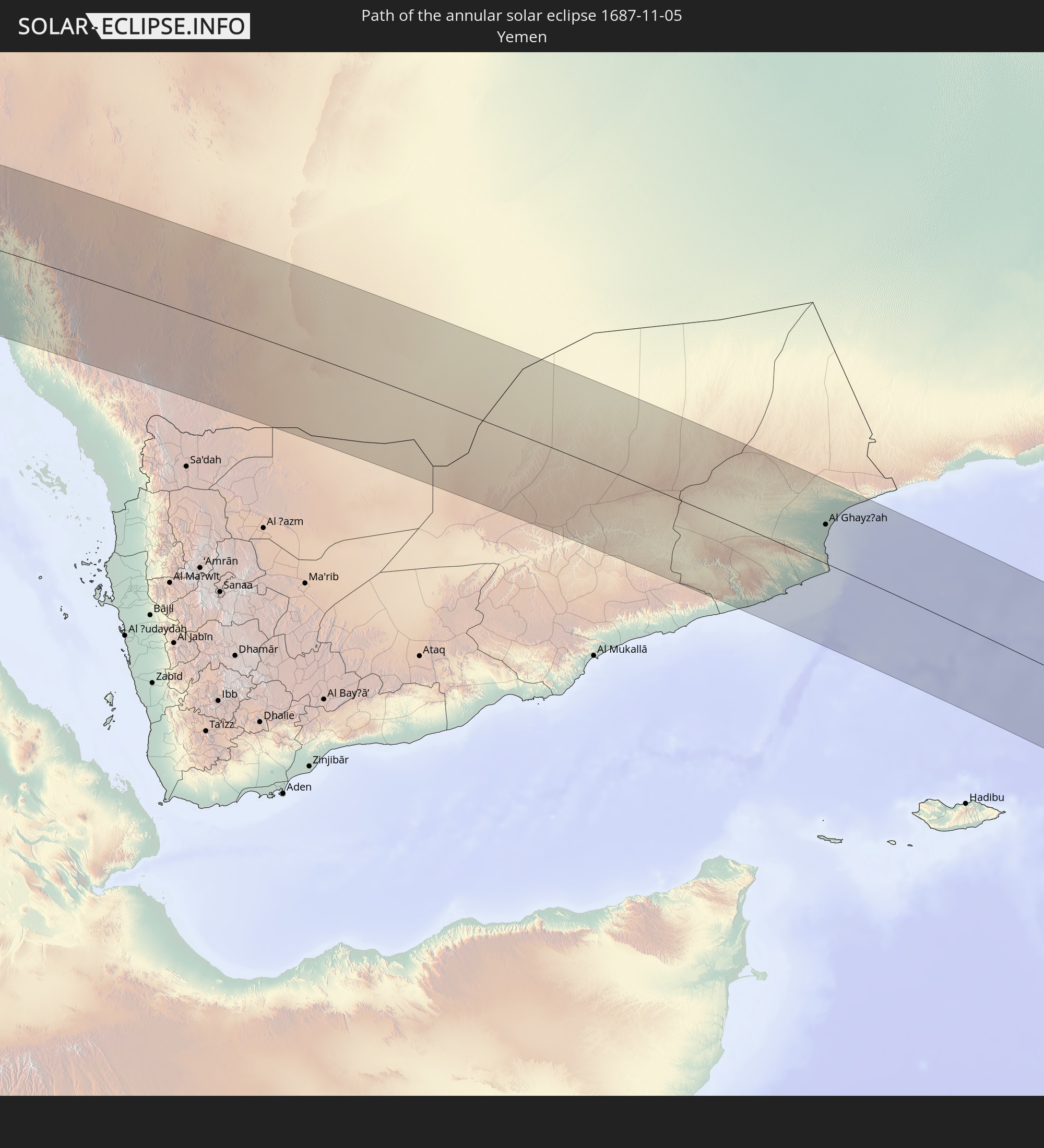 Yemen
Yemen
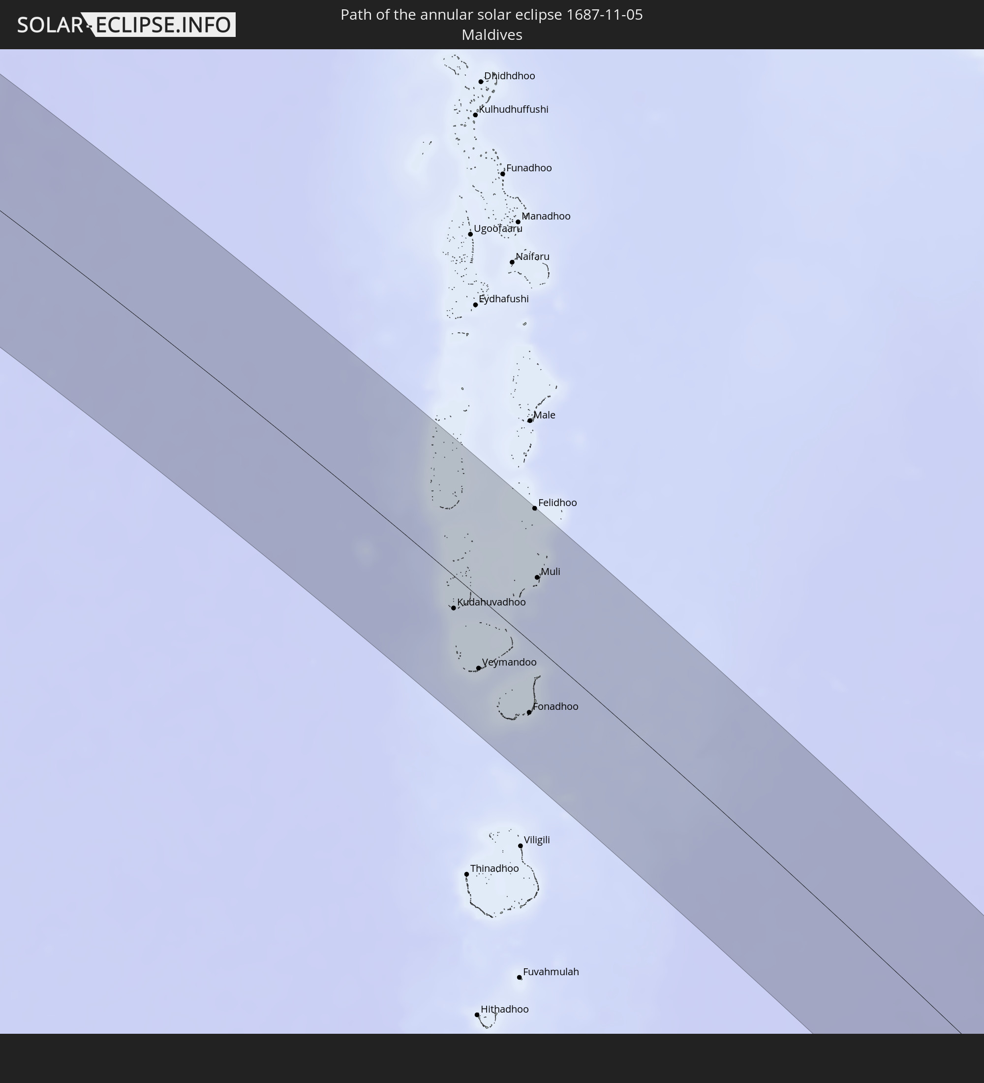 Maldives
 Australia
In den folgenden Ländern ist die Sonnenfinsternis partiell zu sehen
 Russia
 New Zealand
 Angola
 Democratic Republic of the Congo
 Zambia
 Zimbabwe
 Rwanda
 Burundi
 Tanzania
 Uganda
 Mozambique
 Malawi
 Ethiopia
 Kenya
Kenya
 Saudi Arabia
 Eritrea
 Iraq
Iraq
 French Southern and Antarctic Lands
 Somalia
 Djibouti
 Yemen
Yemen
 Madagascar
 Comoros
 Iran
Iran
 Azerbaijan
 Mayotte
 Seychelles
 Kazakhstan
 Kuwait
 Bahrain
 Qatar
Qatar
 United Arab Emirates
 Oman
Oman
 Turkmenistan
 Réunion
 Uzbekistan
 Mauritius
 Afghanistan
 Pakistan
 Tajikistan
 India
India
 Kyrgyzstan
 British Indian Ocean Territory
 Maldives
 China
China
 Sri Lanka
 Nepal
Nepal
 Bangladesh
 Bhutan
 Myanmar
 Indonesia
 Cocos Islands
 Thailand
 Malaysia
 Laos
Laos
 Vietnam
 Cambodia
 Singapore
 Christmas Island
 Australia
 Brunei
 Philippines
 East Timor
 Palau
Palau
 Federated States of Micronesia
 Papua New Guinea
 Solomon Islands
 New Caledonia
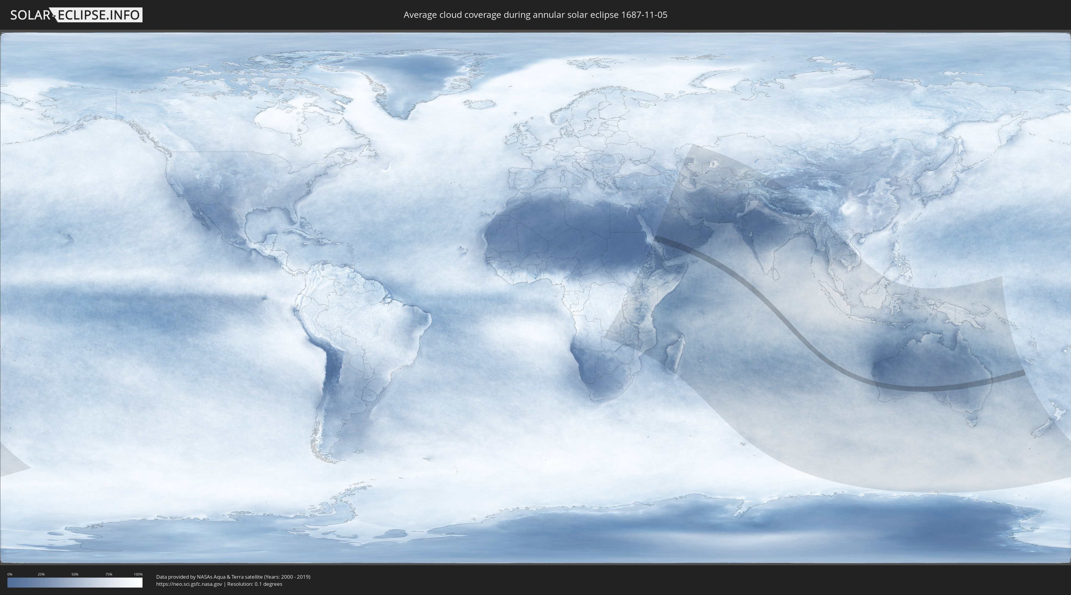
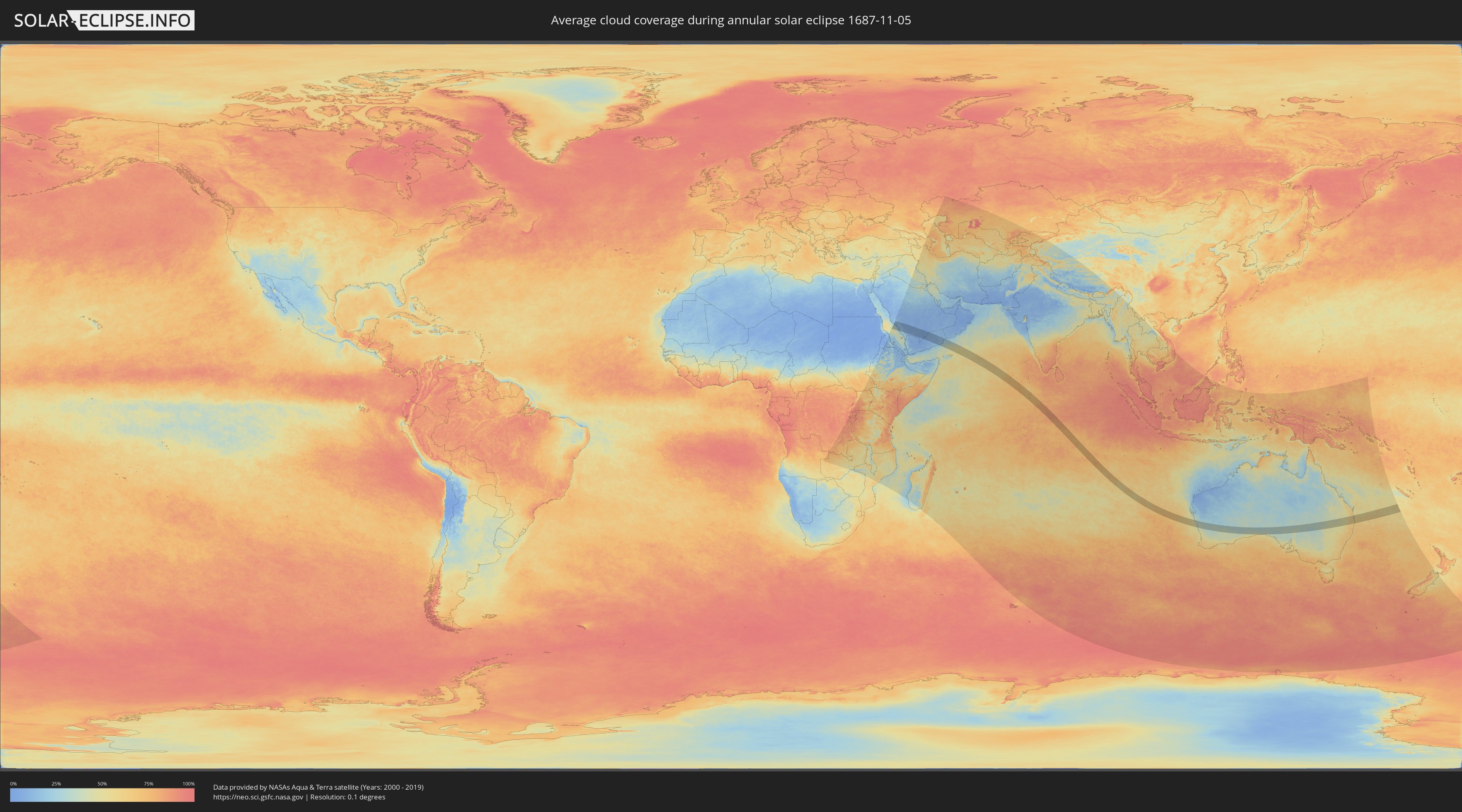
How will be the weather during the annular solar eclipse on 11/05/1687?
Where is the best place to see the annular solar eclipse of 11/05/1687?
The following maps show the average cloud coverage for the day of the annular solar eclipse.
With the help of these maps, it is possible to find the place along the eclipse path, which has the best
chance of a cloudless sky.
Nevertheless, you should consider local circumstances and inform about the weather of your chosen
observation site.
The data is provided by NASAs satellites
AQUA and TERRA.
The cloud maps are averaged over a period of 19 years (2000 - 2019).
Detailed country maps
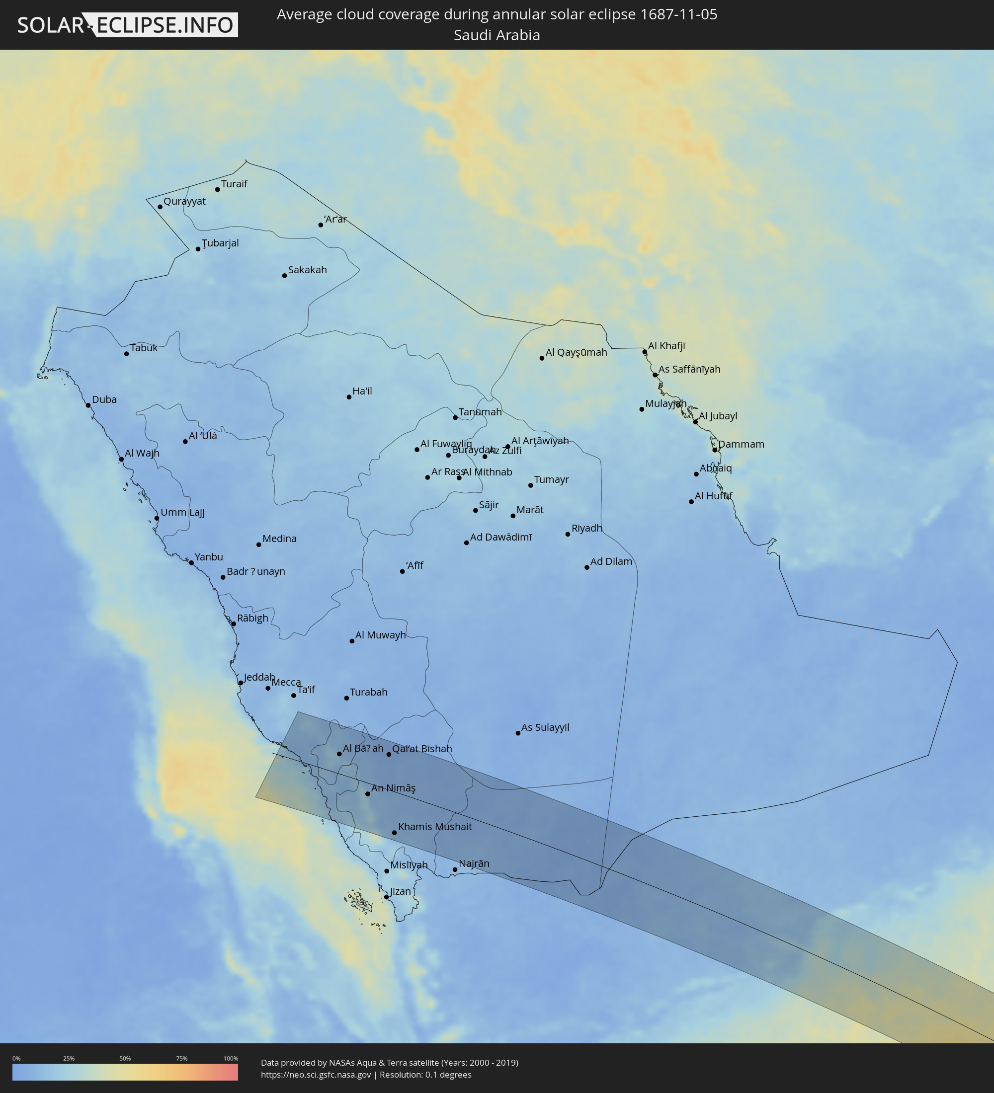 Saudi Arabia
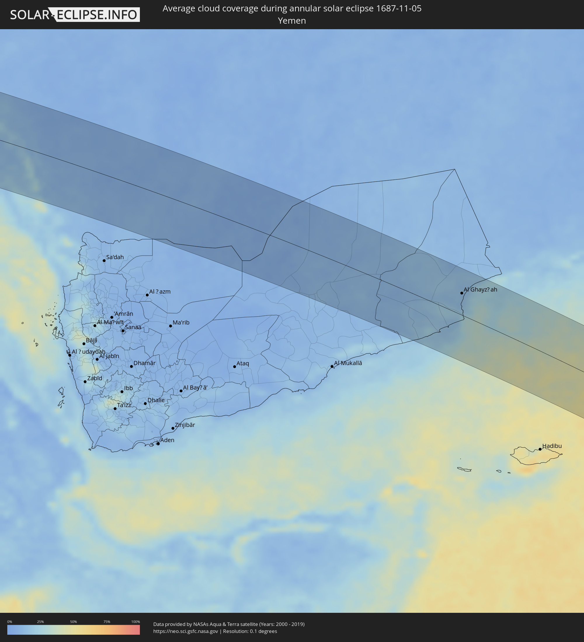 Yemen
Yemen
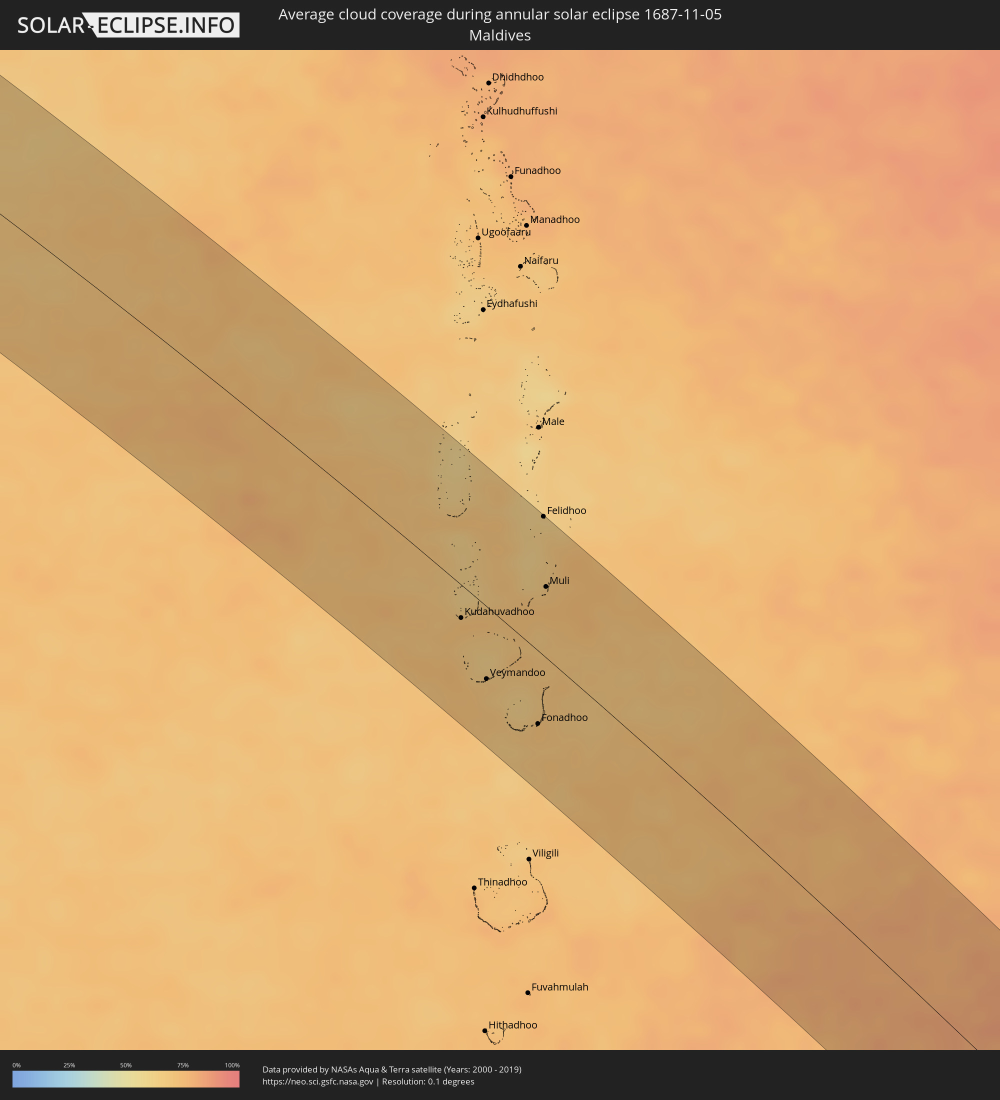 Maldives
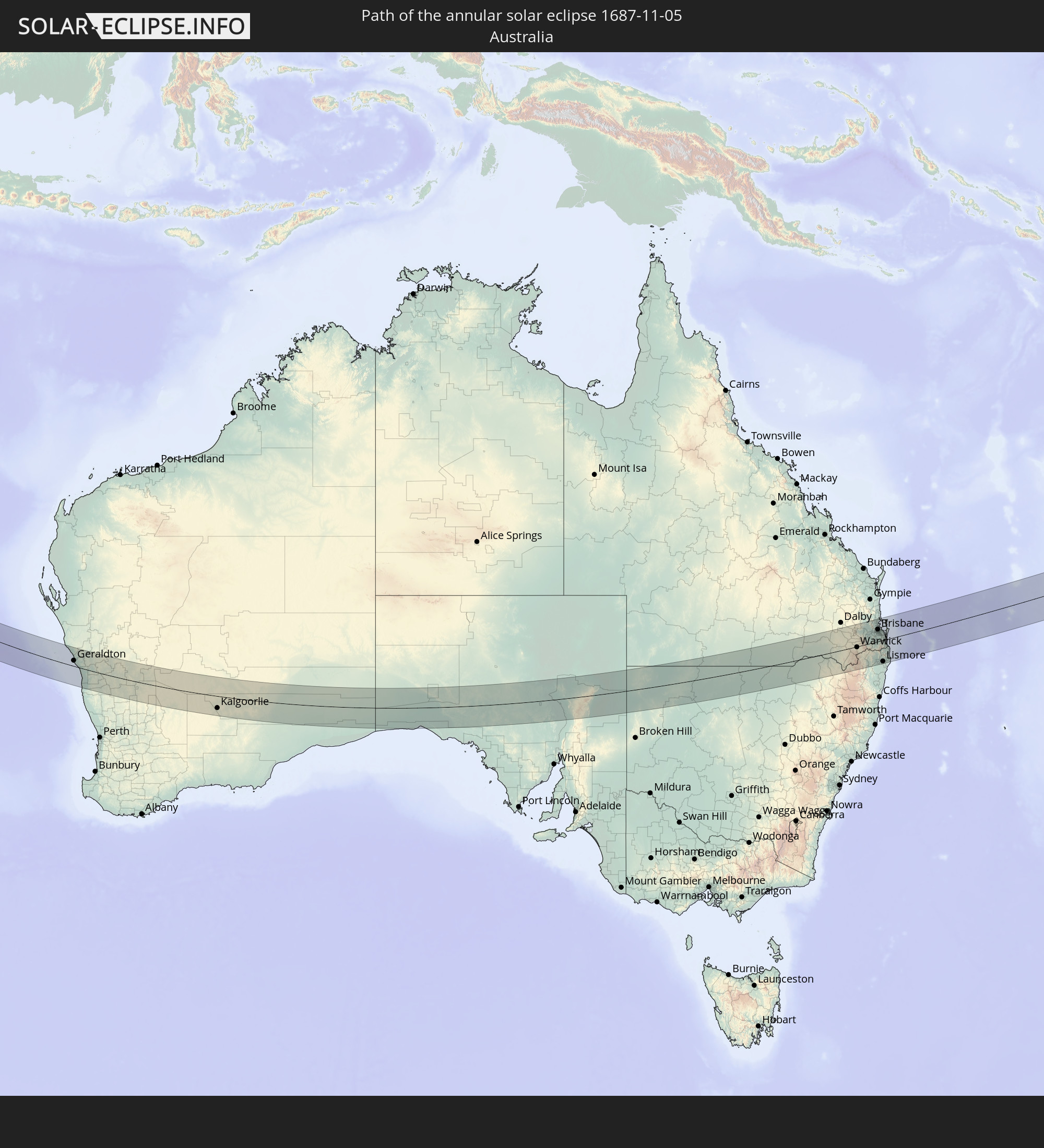
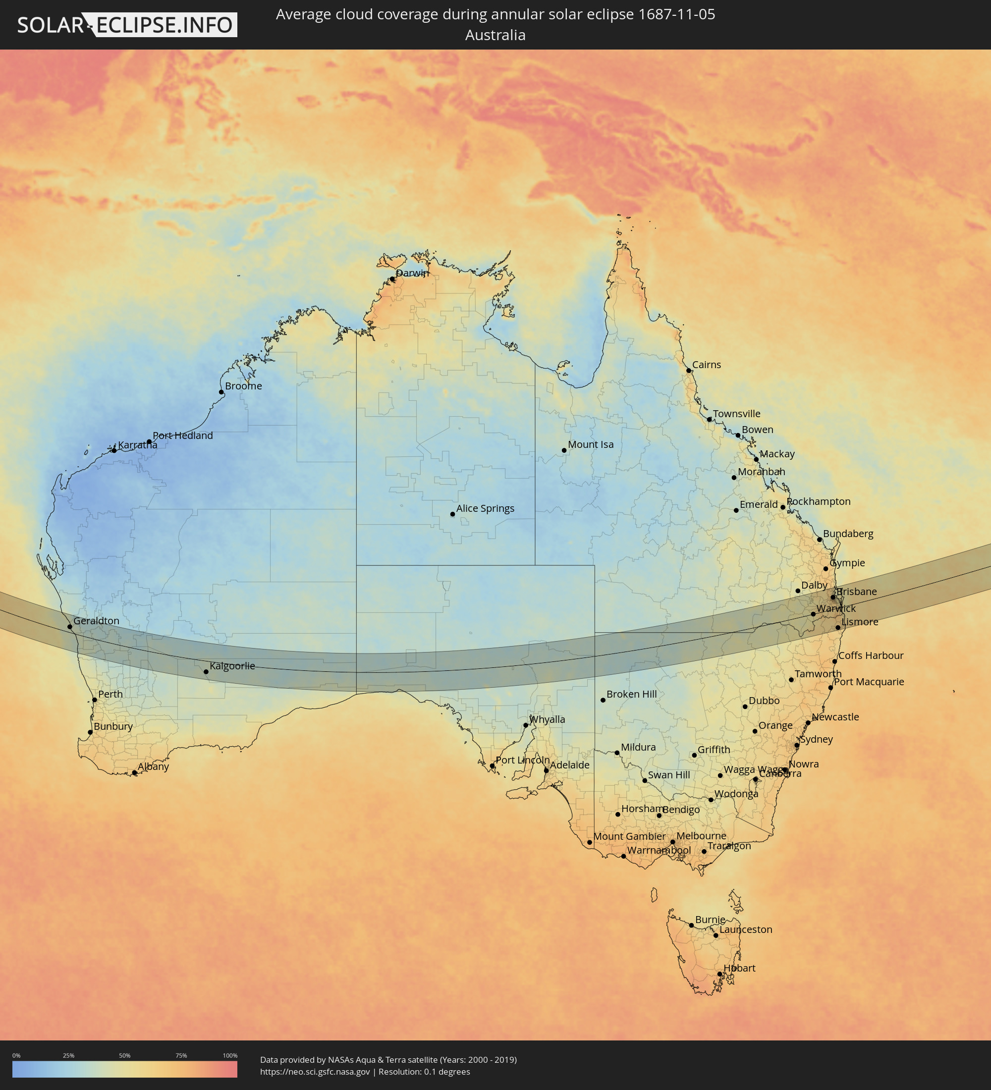 Australia
Cities inside the path of the eclipse
The following table shows all locations with a population of more than 5,000 inside the eclipse path. Cities which have more than 100,000 inhabitants are marked bold. A click at the locations opens a detailed map.
| City | Type | Eclipse duration | Local time of max. eclipse | Distance to central line | Ø Cloud coverage |
|
Al Mindak, Al Bahah
|
annular | - | 06:34:36 UTC+03:06 | 54 km | 19% |
|
Al Bāḩah, Al Bahah
|
annular | - | 06:34:38 UTC+03:06 | 45 km | 17% |
|
Al Majāridah, 'Asir
|
annular | - | 06:34:56 UTC+03:06 | 35 km | 15% |
|
An Nimāş, 'Asir
|
annular | - | 06:34:55 UTC+03:06 | 26 km | 24% |
|
Tabālah, 'Asir
|
annular | - | 06:34:37 UTC+03:06 | 68 km | 7% |
|
Abha, 'Asir
|
annular | - | 06:35:17 UTC+03:06 | 112 km | 22% |
|
Qal‘at Bīshah, 'Asir
|
annular | - | 06:34:35 UTC+03:06 | 80 km | 6% |
|
Khamis Mushait, 'Asir
|
annular | - | 06:35:15 UTC+03:06 | 95 km | 12% |
|
Al Ghayz̧ah, Al Mahrah
|
annular | - | 06:37:25 UTC+03:06 | 50 km | 14% |
|
Kudahuvadhoo, Dhaalu Atholhu
|
annular | - | 08:53:26 UTC+04:54 | 22 km | 72% |
|
Veymandoo, Thaa Atholhu
|
annular | - | 08:54:28 UTC+04:54 | 48 km | 69% |
|
Fonadhoo, Laamu
|
annular | - | 08:55:32 UTC+04:54 | 49 km | 71% |
|
Felidhoo, Vaavu Atholhu
|
annular | - | 08:52:53 UTC+04:54 | 93 km | 63% |
|
Muli, Meemu Atholhu
|
annular | - | 08:53:49 UTC+04:54 | 47 km | 71% |
|
Geraldton, Western Australia
|
annular | - | 14:28:02 UTC+08:00 | 25 km | 41% |
|
Kalgoorlie, Western Australia
|
annular | - | 14:42:15 UTC+08:00 | 54 km | 36% |
|
Moree, New South Wales
|
annular | - | 17:12:41 UTC+10:00 | 90 km | 46% |
|
Toowoomba, Queensland
|
annular | - | 17:14:15 UTC+10:00 | 70 km | 51% |
|
Rangeville, Queensland
|
annular | - | 17:14:15 UTC+10:00 | 66 km | 51% |
|
Warwick, Queensland
|
annular | - | 17:14:01 UTC+10:00 | 4 km | 51% |
|
Gatton, Queensland
|
annular | - | 17:14:22 UTC+10:00 | 62 km | 56% |
|
Brassall, Queensland
|
annular | - | 17:14:30 UTC+10:00 | 47 km | 56% |
|
Raceview, Queensland
|
annular | - | 17:14:29 UTC+10:00 | 42 km | 58% |
|
Booval, Queensland
|
annular | - | 17:14:30 UTC+10:00 | 44 km | 58% |
|
Redbank Plains, Queensland
|
annular | - | 17:14:31 UTC+10:00 | 39 km | 62% |
|
Samford Valley, Queensland
|
annular | - | 17:14:37 UTC+10:00 | 69 km | 66% |
|
Goodna, Queensland
|
annular | - | 17:14:32 UTC+10:00 | 42 km | 62% |
|
Springfield, Queensland
|
annular | - | 17:14:32 UTC+10:00 | 37 km | 61% |
|
Ferny Hills, Queensland
|
annular | - | 17:14:38 UTC+10:00 | 64 km | 66% |
|
Caboolture, Queensland
|
annular | - | 17:14:45 UTC+10:00 | 98 km | 53% |
|
Burpengary, Queensland
|
annular | - | 17:14:44 UTC+10:00 | 90 km | 54% |
|
Taringa, Queensland
|
annular | - | 17:14:37 UTC+10:00 | 53 km | 65% |
|
Everton Park, Queensland
|
annular | - | 17:14:39 UTC+10:00 | 62 km | 67% |
|
Bridegman Downs, Queensland
|
annular | - | 17:14:40 UTC+10:00 | 67 km | 67% |
|
Stafford Heights, Queensland
|
annular | - | 17:14:39 UTC+10:00 | 63 km | 67% |
|
Murrumba Downs, Queensland
|
annular | - | 17:14:42 UTC+10:00 | 77 km | 61% |
|
Stafford, Queensland
|
annular | - | 17:14:39 UTC+10:00 | 61 km | 67% |
|
Chermside West, Queensland
|
annular | - | 17:14:40 UTC+10:00 | 64 km | 67% |
|
Brisbane, Queensland
|
annular | - | 17:14:38 UTC+10:00 | 54 km | 65% |
|
Windsor, Queensland
|
annular | - | 17:14:39 UTC+10:00 | 58 km | 67% |
|
Bracken Ridge, Queensland
|
annular | - | 17:14:42 UTC+10:00 | 71 km | 61% |
|
Zillmere, Queensland
|
annular | - | 17:14:41 UTC+10:00 | 66 km | 67% |
|
Casino, New South Wales
|
annular | - | 17:14:04 UTC+10:00 | 96 km | 63% |
|
Greenslopes, Queensland
|
annular | - | 17:14:37 UTC+10:00 | 50 km | 65% |
|
Brighton, Queensland
|
annular | - | 17:14:42 UTC+10:00 | 72 km | 52% |
|
Clontarf, Queensland
|
annular | - | 17:14:44 UTC+10:00 | 76 km | 52% |
|
Upper Mount Gravatt, Queensland
|
annular | - | 17:14:37 UTC+10:00 | 43 km | 63% |
|
Margate, Queensland
|
annular | - | 17:14:44 UTC+10:00 | 77 km | 47% |
|
Mansfield, Queensland
|
annular | - | 17:14:37 UTC+10:00 | 45 km | 64% |
|
Logan City, Queensland
|
annular | - | 17:14:35 UTC+10:00 | 34 km | 63% |
|
Springwood, Queensland
|
annular | - | 17:14:36 UTC+10:00 | 37 km | 63% |
|
Waterford West, Queensland
|
annular | - | 17:14:34 UTC+10:00 | 28 km | 60% |
|
Bongaree, Queensland
|
annular | - | 17:14:49 UTC+10:00 | 93 km | 47% |
|
Tamborine Mountain, Queensland
|
annular | - | 17:14:29 UTC+10:00 | 4 km | 64% |
|
Beenleigh, Queensland
|
annular | - | 17:14:35 UTC+10:00 | 24 km | 61% |
|
Cleveland, Queensland
|
annular | - | 17:14:41 UTC+10:00 | 42 km | 50% |
|
Lismore, New South Wales
|
annular | - | 17:14:09 UTC+10:00 | 97 km | 61% |
|
Upper Coomera, Queensland
|
annular | - | 17:14:32 UTC+10:00 | 1 km | 62% |
|
Oxenford, Queensland
|
annular | - | 17:14:33 UTC+10:00 | 2 km | 62% |
|
Murwillumbah, New South Wales
|
annular | - | 17:14:23 UTC+10:00 | 47 km | 63% |
|
Gold Coast, Queensland
|
annular | - | 17:14:32 UTC+10:00 | 13 km | 57% |
|
Banora Point, New South Wales
|
annular | - | 17:14:28 UTC+10:00 | 38 km | 56% |
|
Kingscliff, New South Wales
|
annular | - | 17:14:28 UTC+10:00 | 44 km | 58% |
|
Byron Bay, New South Wales
|
annular | - | 17:14:19 UTC+10:00 | 86 km | 59% |