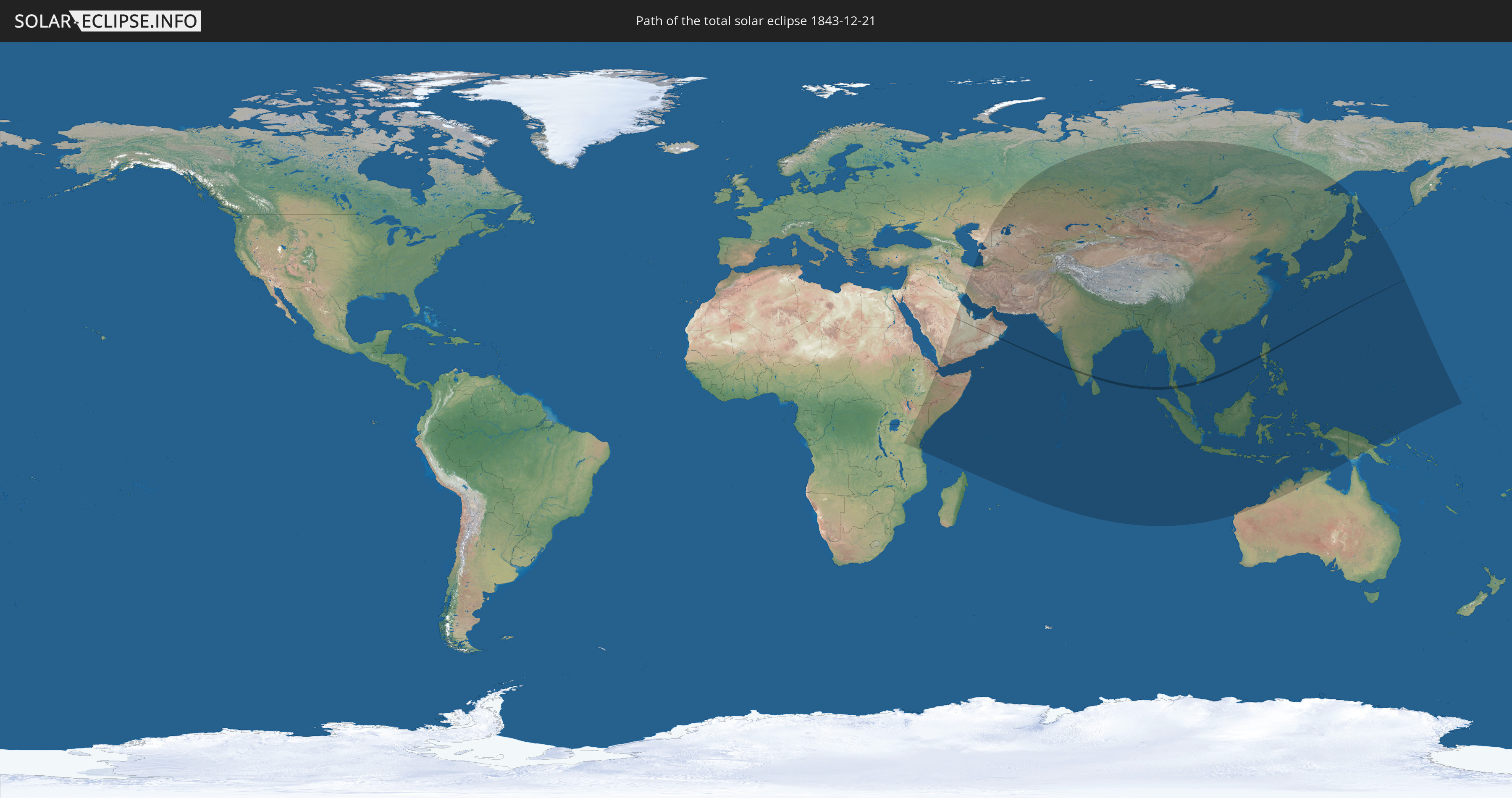
Total solar eclipse of 12/21/1843
| Day of week: | Thursday |
| Maximum duration of eclipse: | 01m43s |
| Maximum width of eclipse path: | 66 km |
| Saros cycle: | 139 |
| Coverage: | 100% |
| Magnitude: | 1.0165 |
| Gamma: | 0.5227 |
Wo kann man die Sonnenfinsternis vom 12/21/1843 sehen?
Die Sonnenfinsternis am 12/21/1843 kann man in 57 Ländern als partielle Sonnenfinsternis beobachten.
Der Finsternispfad verläuft durch 6 Länder. Nur in diesen Ländern ist sie als total Sonnenfinsternis zu sehen.
In den folgenden Ländern ist die Sonnenfinsternis total zu sehen
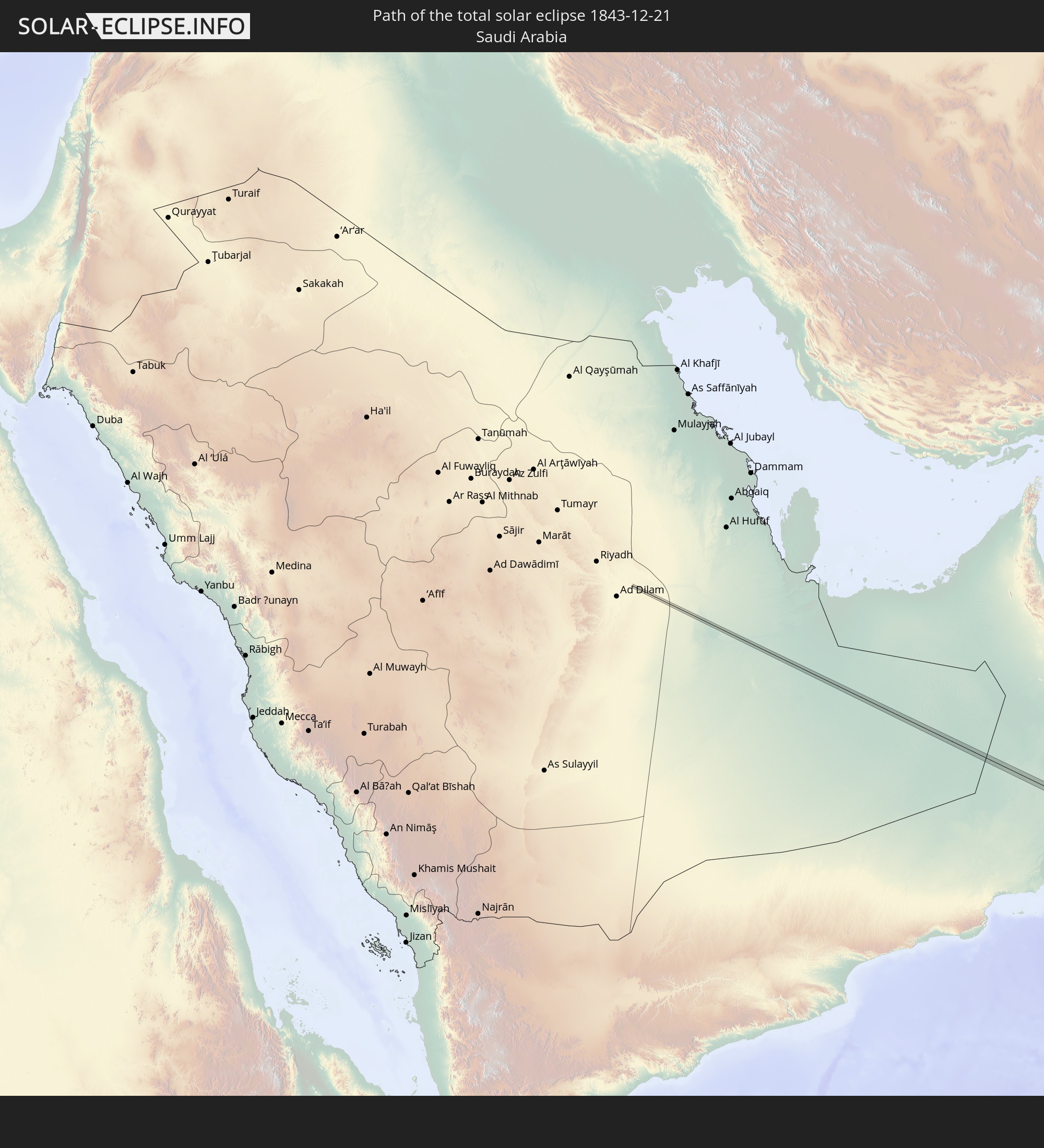 Saudi Arabia
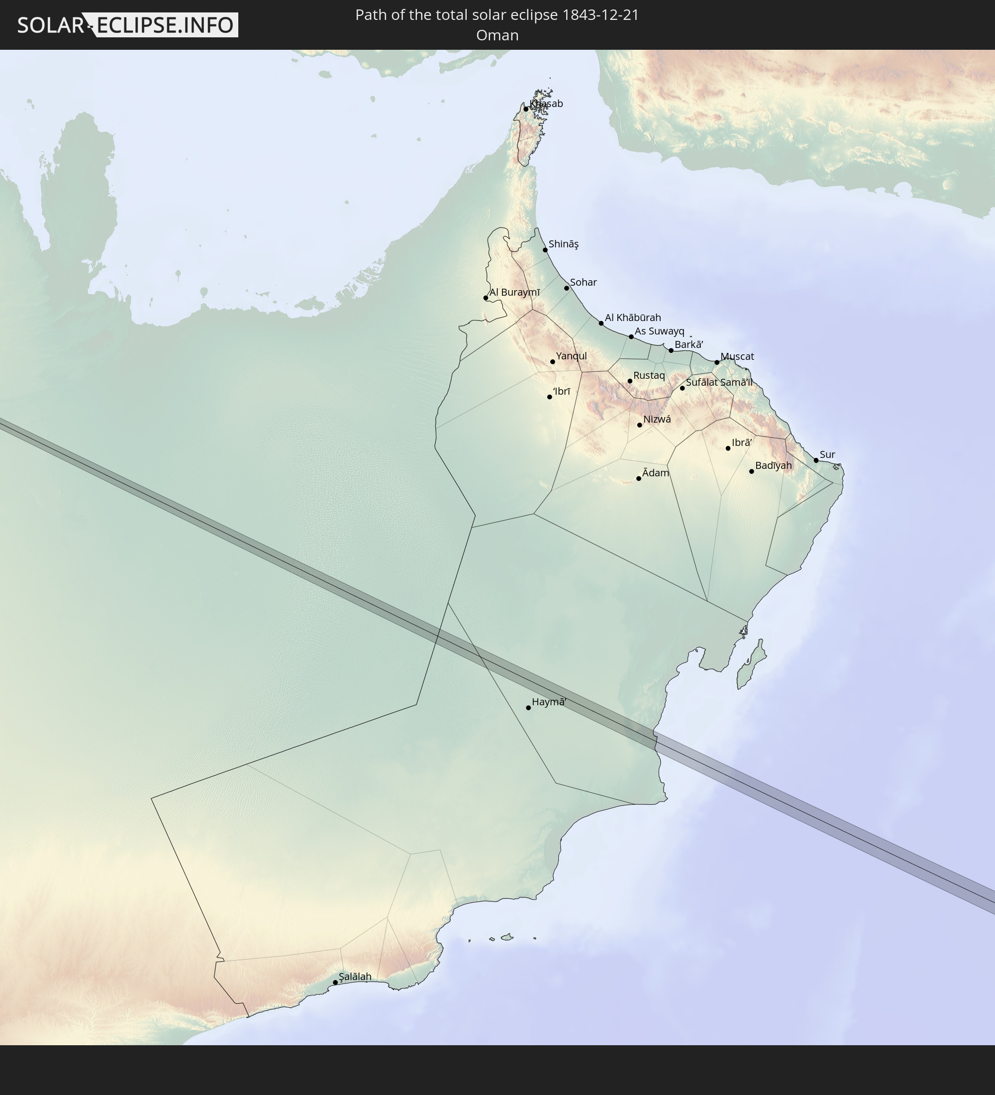 Oman
Oman
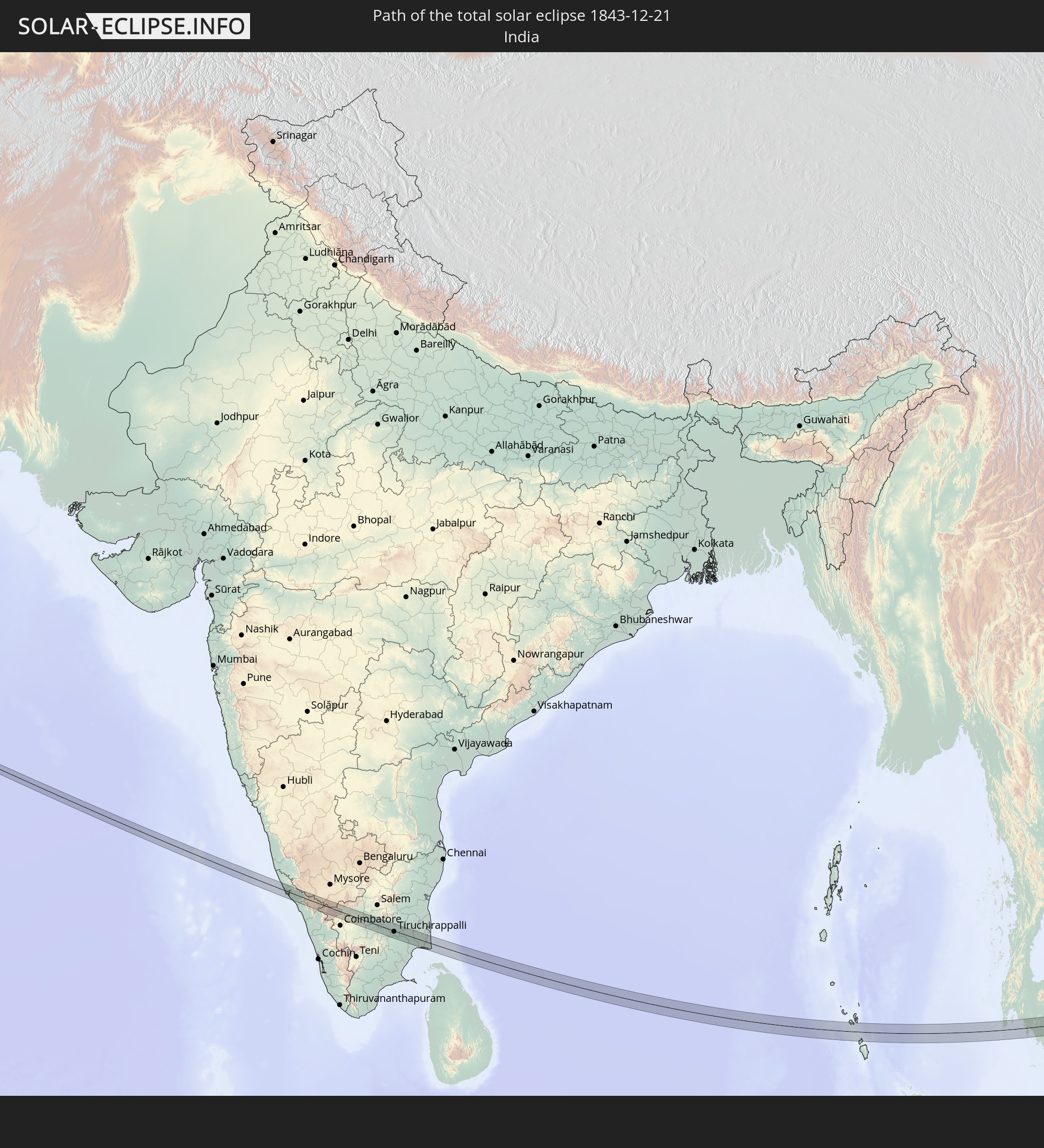 India
India
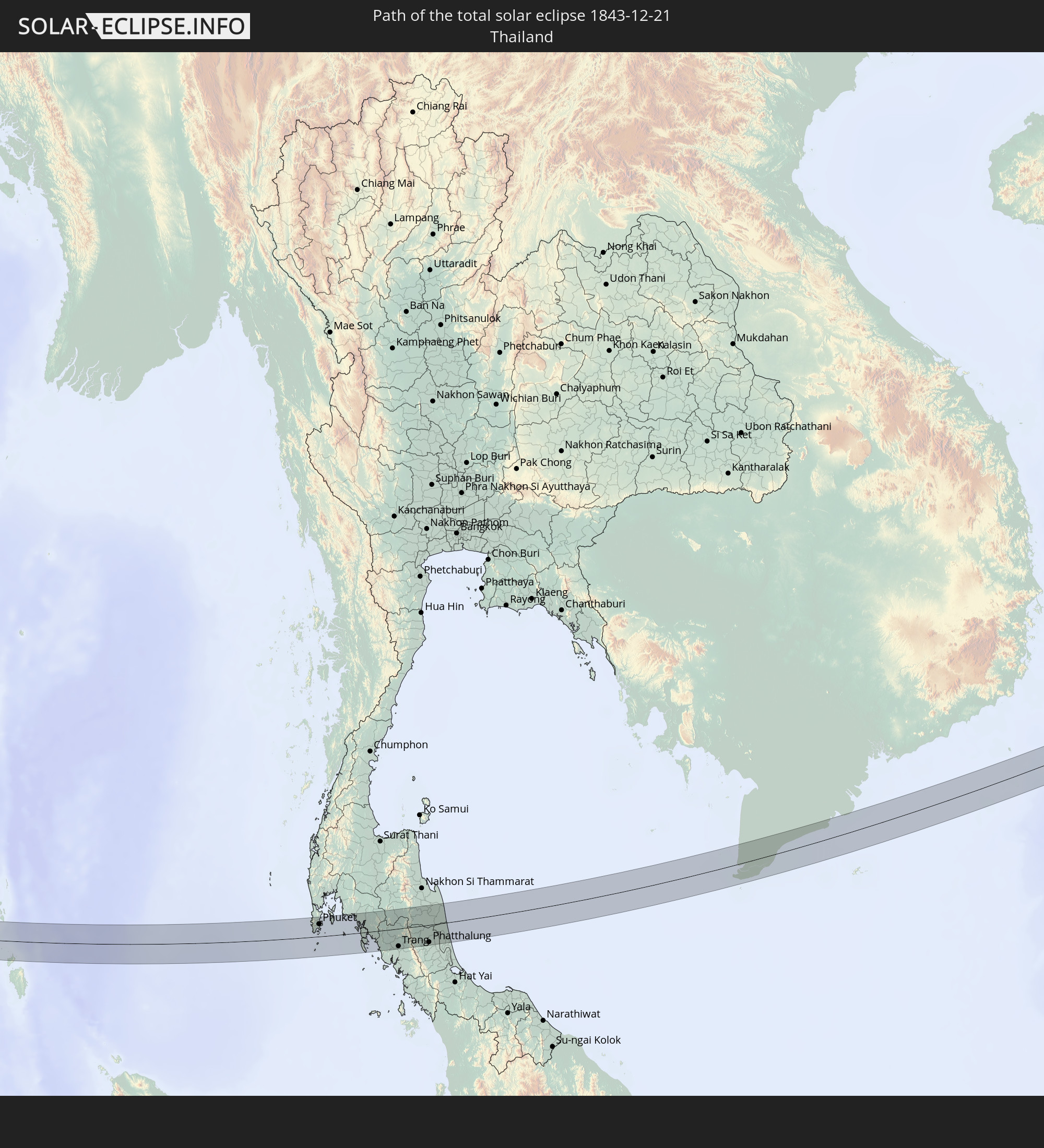 Thailand
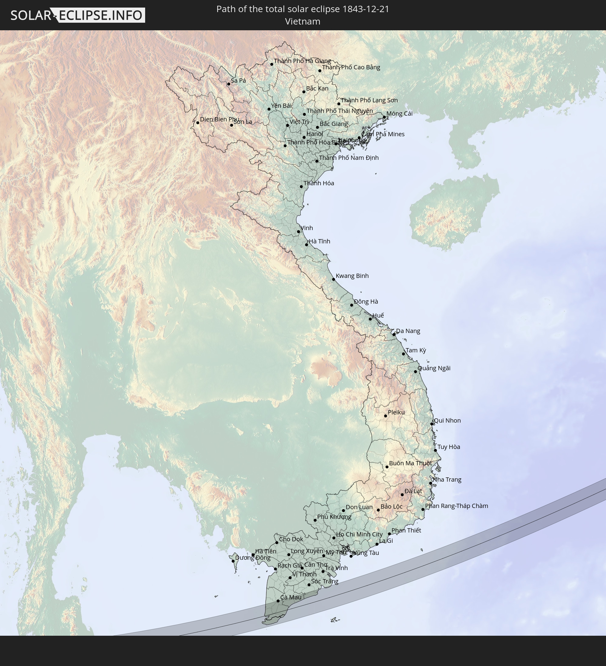 Vietnam
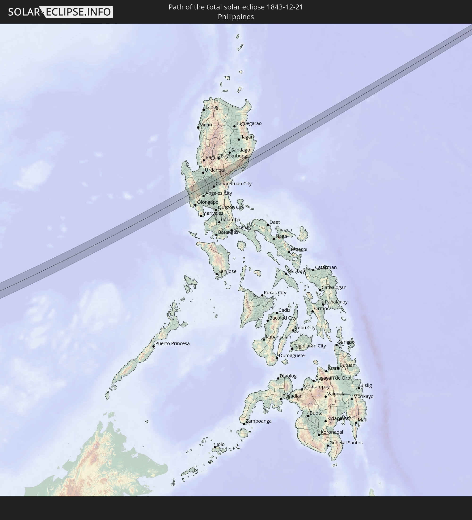 Philippines
In den folgenden Ländern ist die Sonnenfinsternis partiell zu sehen
 Russia
 Tanzania
 Ethiopia
 Kenya
Kenya
 Saudi Arabia
 Somalia
 Djibouti
 Yemen
Yemen
 Iran
Iran
 Seychelles
 Kazakhstan
 Bahrain
 Qatar
Qatar
 United Arab Emirates
 Oman
Oman
 Turkmenistan
 Uzbekistan
 Mauritius
 Afghanistan
 Pakistan
 Tajikistan
 India
India
 Kyrgyzstan
 British Indian Ocean Territory
 Maldives
 China
China
 Sri Lanka
 Nepal
Nepal
 Mongolia
 Bangladesh
 Bhutan
 Myanmar
 Indonesia
 Cocos Islands
 Thailand
 Malaysia
 Laos
Laos
 Vietnam
 Cambodia
 Singapore
 Christmas Island
 Australia
 Macau
Macau
 Hong Kong
 Brunei
 Taiwan
 Philippines
 Japan
Japan
 East Timor
 North Korea
 South Korea
 Palau
Palau
 Federated States of Micronesia
 Papua New Guinea
 Guam
Guam
 Northern Mariana Islands
 Marshall Islands
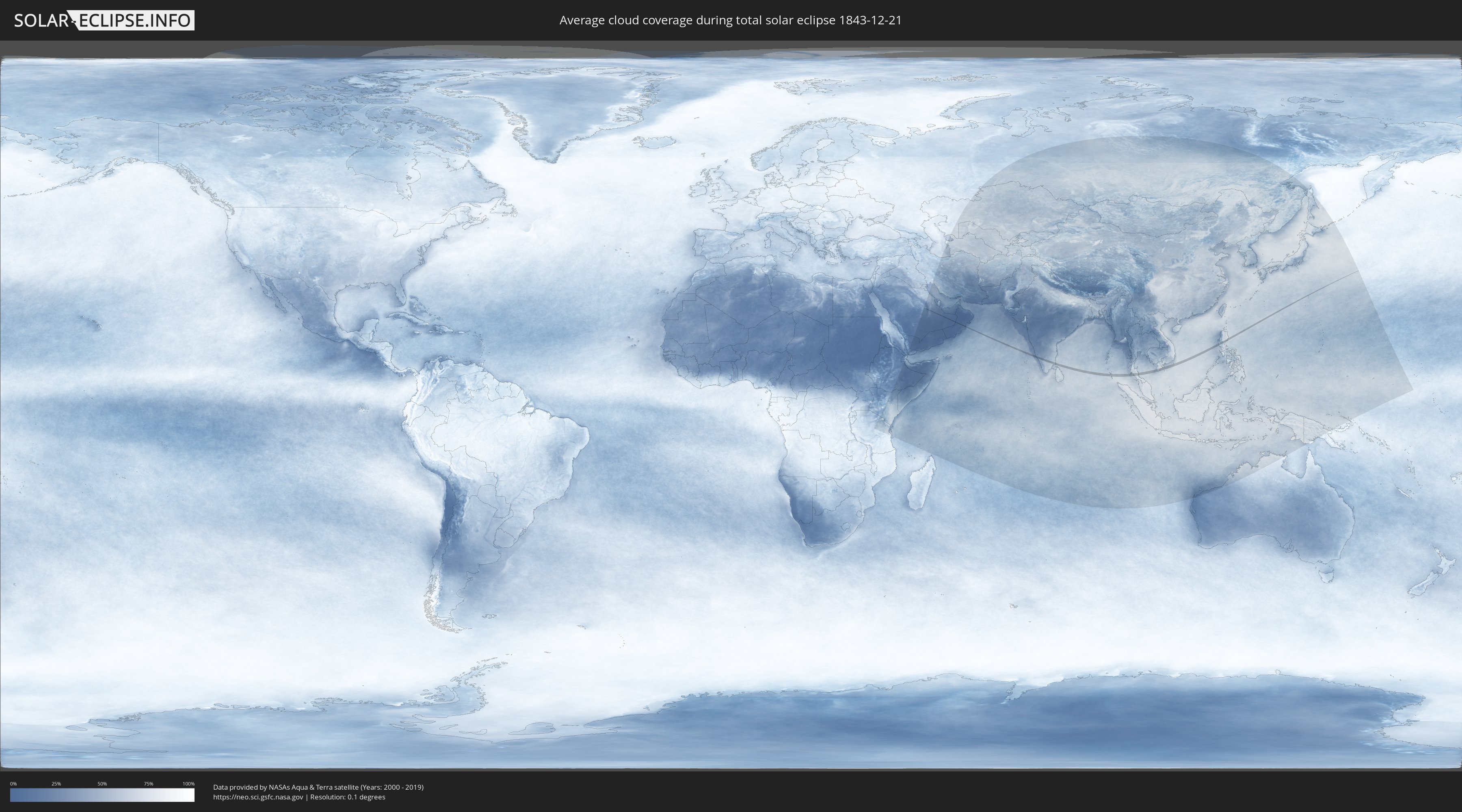
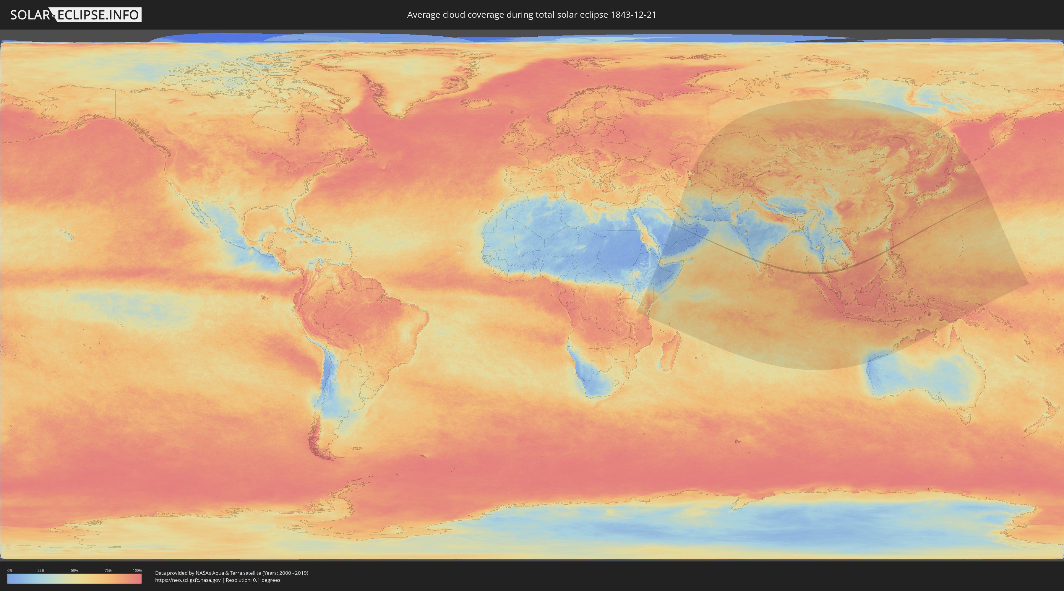
How will be the weather during the total solar eclipse on 12/21/1843?
Where is the best place to see the total solar eclipse of 12/21/1843?
The following maps show the average cloud coverage for the day of the total solar eclipse.
With the help of these maps, it is possible to find the place along the eclipse path, which has the best
chance of a cloudless sky.
Nevertheless, you should consider local circumstances and inform about the weather of your chosen
observation site.
The data is provided by NASAs satellites
AQUA and TERRA.
The cloud maps are averaged over a period of 19 years (2000 - 2019).
Detailed country maps
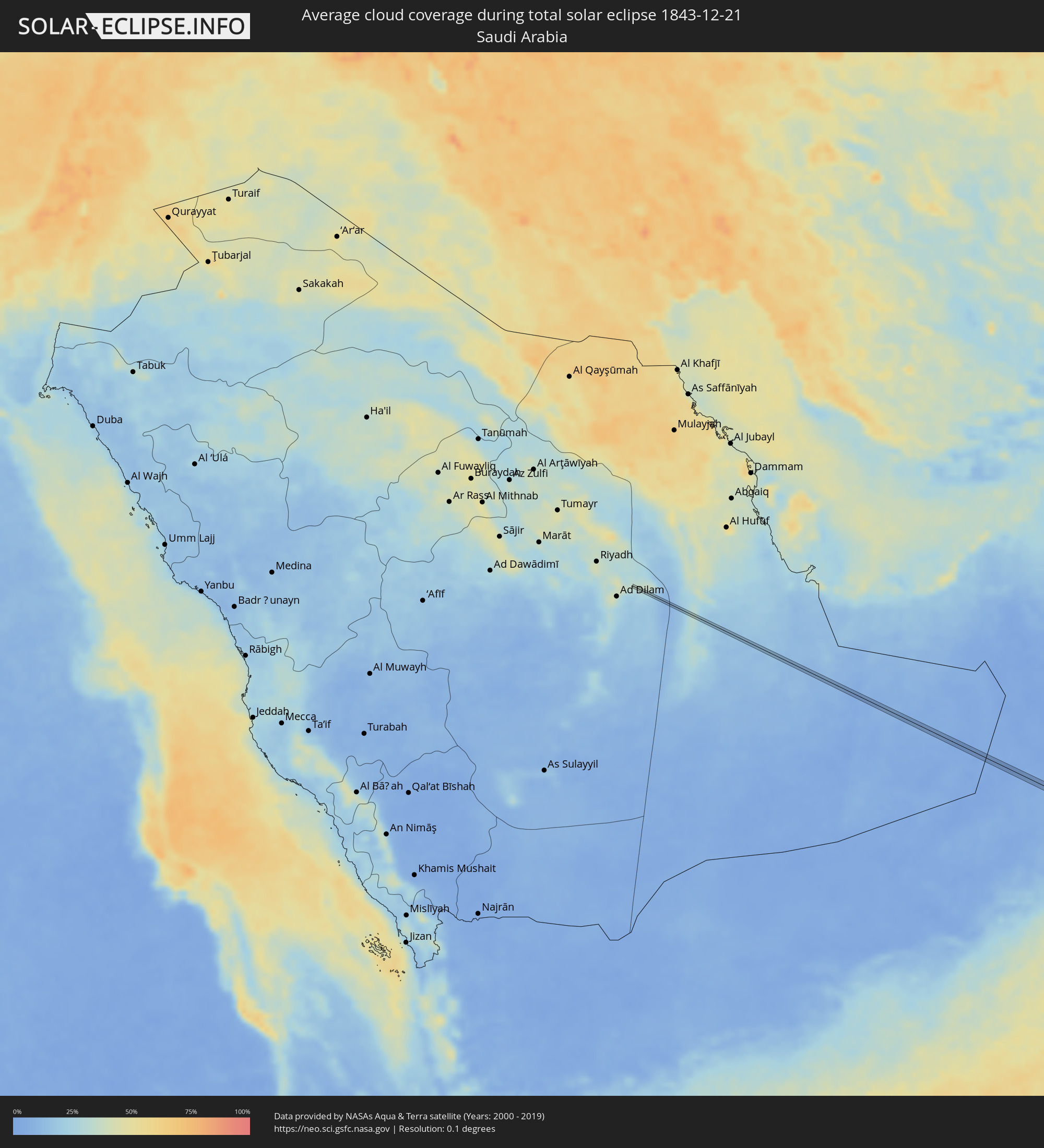 Saudi Arabia
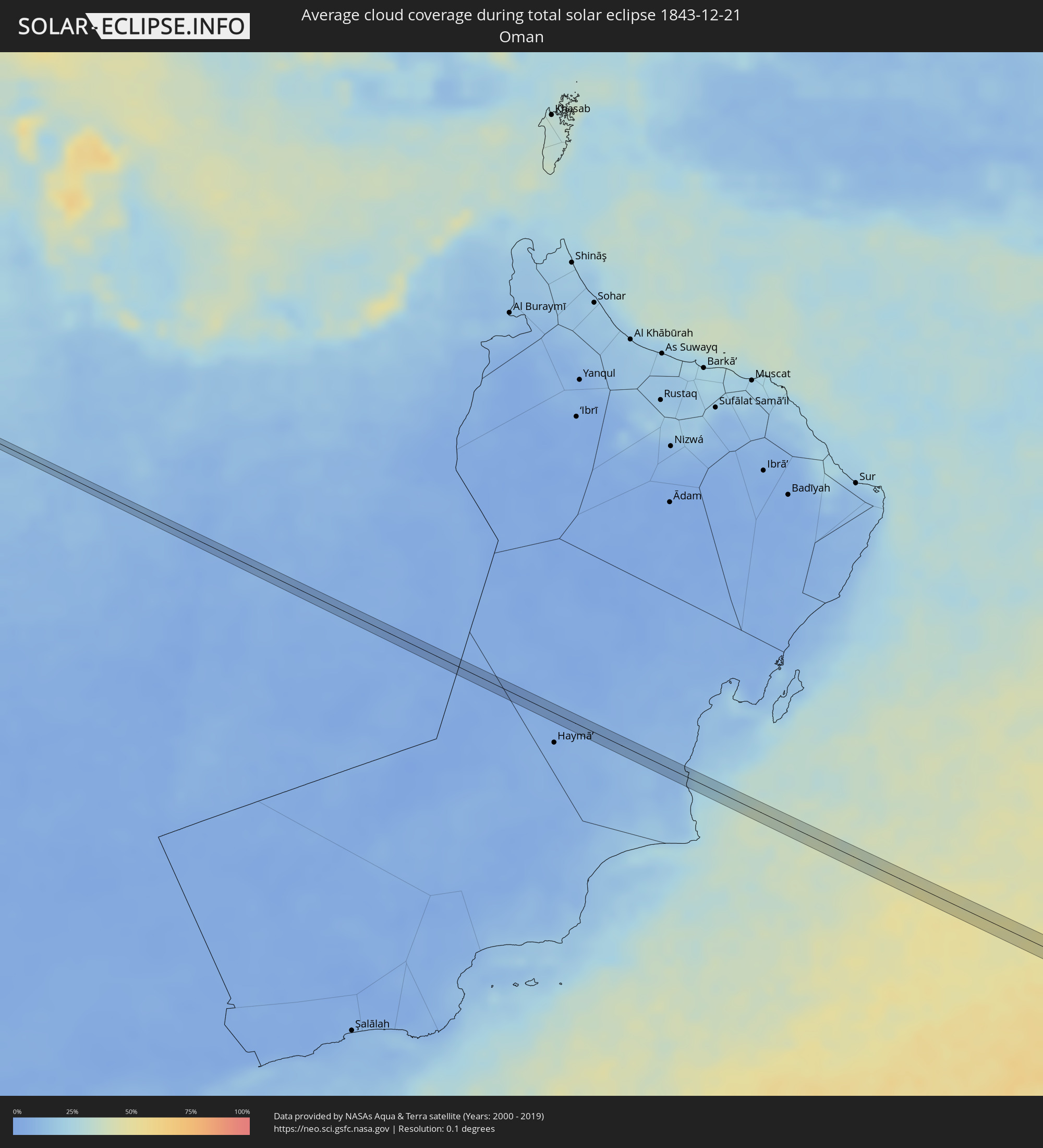 Oman
Oman
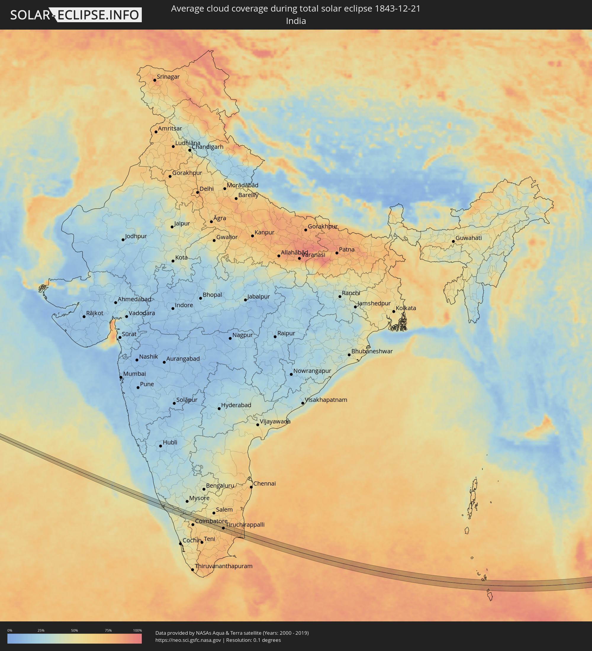 India
India
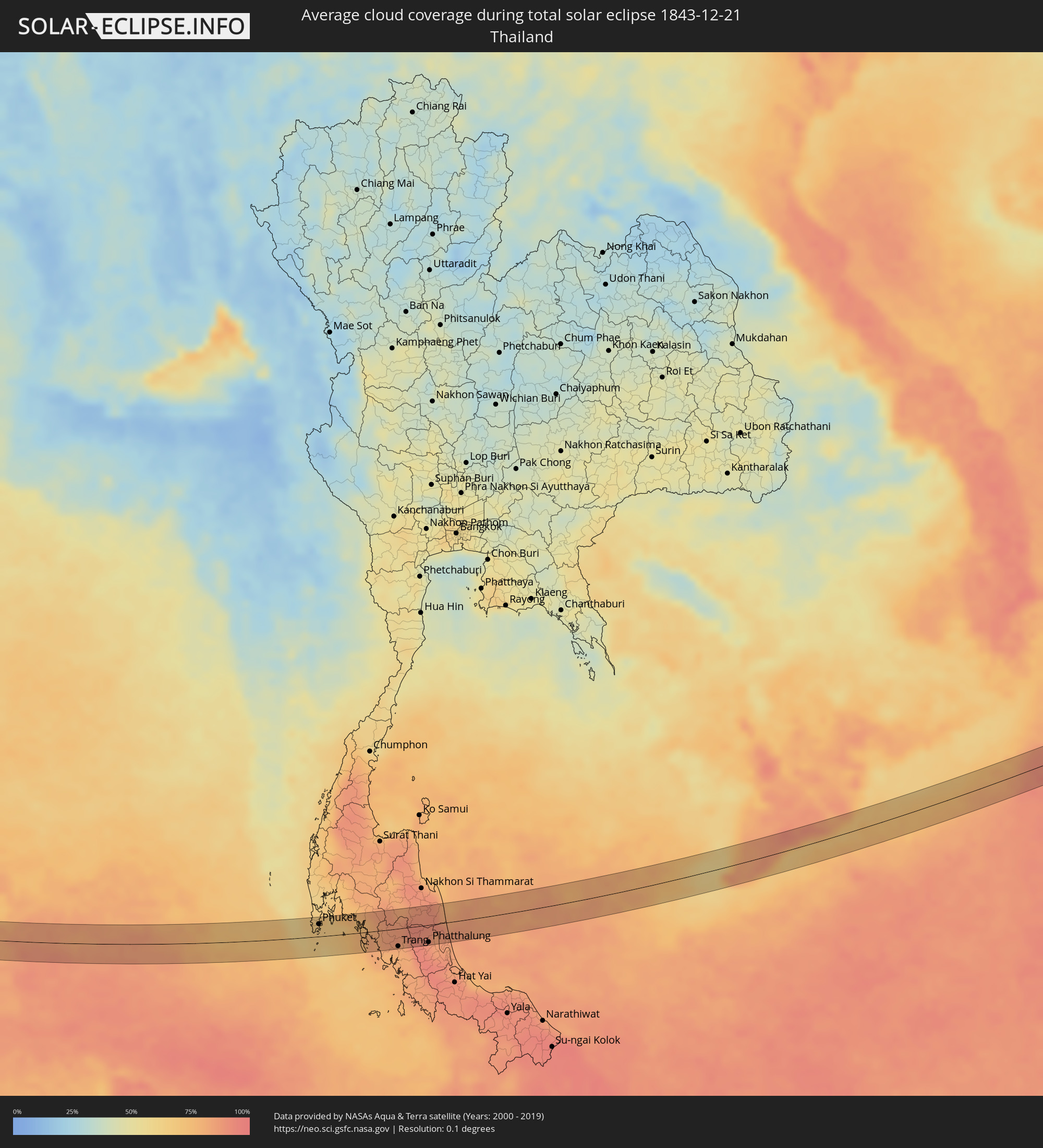 Thailand
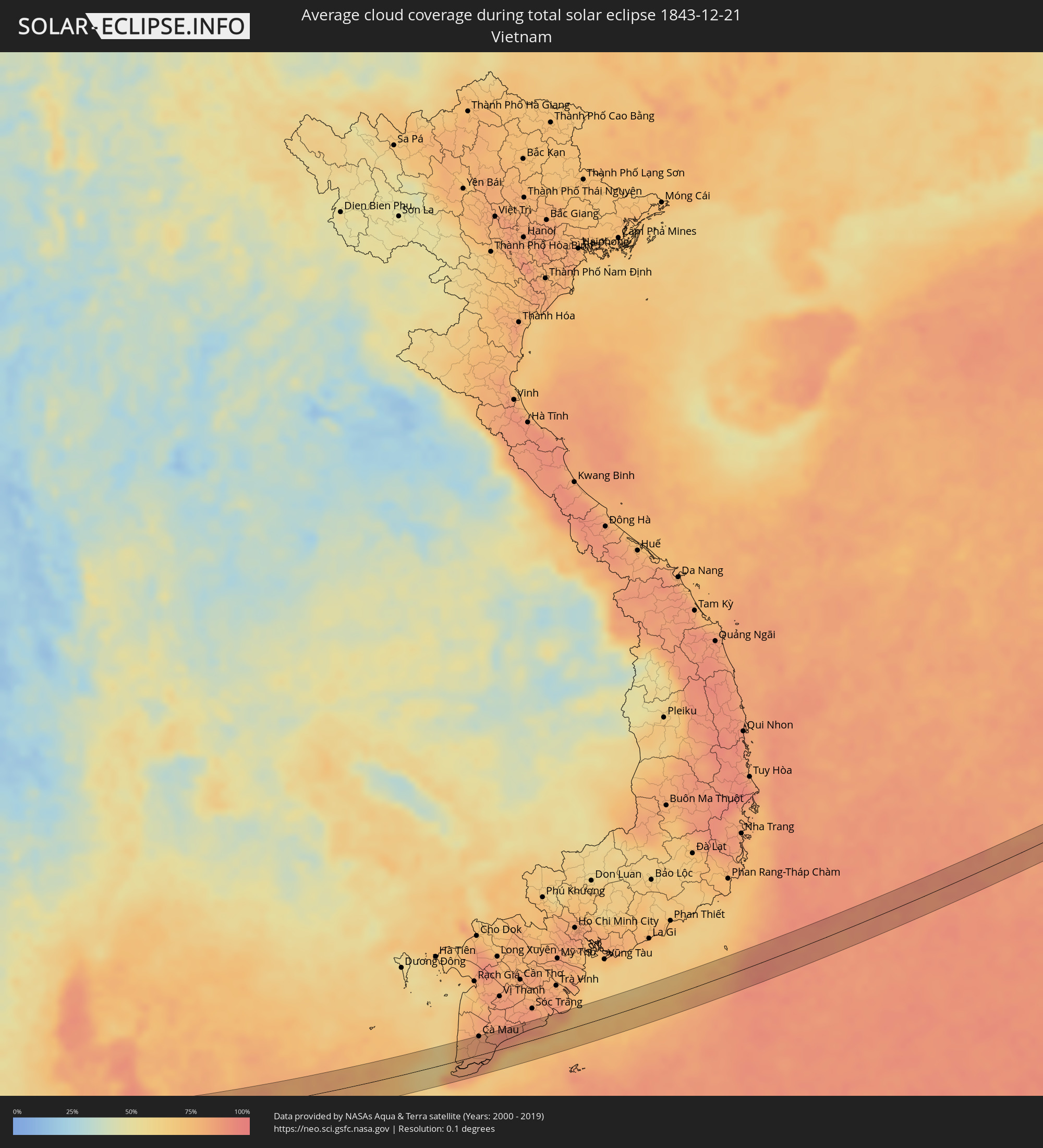 Vietnam
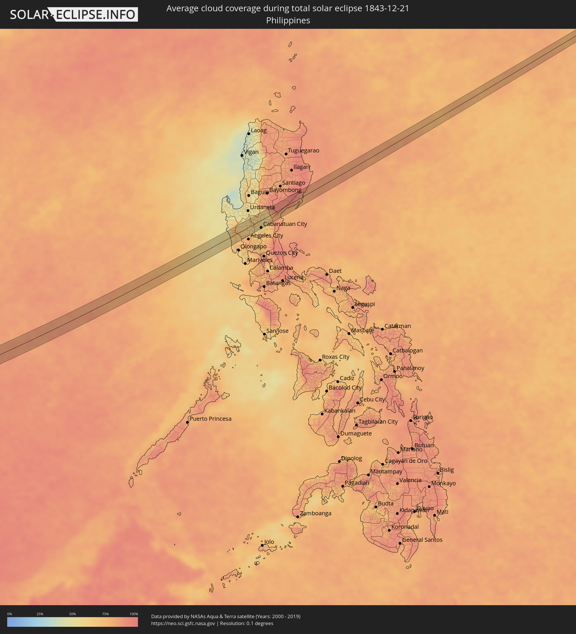 Philippines
Cities inside the path of the eclipse
The following table shows all locations with a population of more than 5,000 inside the eclipse path. Cities which have more than 100,000 inhabitants are marked bold. A click at the locations opens a detailed map.
| City | Type | Eclipse duration | Local time of max. eclipse | Distance to central line | Ø Cloud coverage |
|
Kānnangād, Kerala
|
total | - | 09:14:34 UTC+05:21 | 17 km | 33% |
|
Nīlēshwar, Kerala
|
total | - | 09:14:36 UTC+05:21 | 13 km | 33% |
|
Payyannūr, Kerala
|
total | - | 09:14:40 UTC+05:21 | 1 km | 34% |
|
Pāppinisshēri, Kerala
|
total | - | 09:14:53 UTC+05:21 | 10 km | 33% |
|
Cannanore, Kerala
|
total | - | 09:14:54 UTC+05:21 | 19 km | 33% |
|
Talipparamba, Kerala
|
total | - | 09:14:57 UTC+05:21 | 1 km | 34% |
|
Mattanūr, Kerala
|
total | - | 09:15:18 UTC+05:21 | 4 km | 38% |
|
Perya, Kerala
|
total | - | 09:15:47 UTC+05:21 | 3 km | 42% |
|
Kalpetta, Kerala
|
total | - | 09:16:09 UTC+05:21 | 17 km | 49% |
|
Panamaram, Kerala
|
total | - | 09:16:13 UTC+05:21 | 4 km | 46% |
|
Naduvattam, Tamil Nadu
|
total | - | 09:17:00 UTC+05:21 | 13 km | 44% |
|
Ooty, Tamil Nadu
|
total | - | 09:17:16 UTC+05:21 | 14 km | 51% |
|
Wellington, Tamil Nadu
|
total | - | 09:17:25 UTC+05:21 | 16 km | 59% |
|
Kotagiri, Tamil Nadu
|
total | - | 09:17:35 UTC+05:21 | 7 km | 61% |
|
Mettupalayam, Tamil Nadu
|
total | - | 09:17:42 UTC+05:21 | 17 km | 56% |
|
Kāramadai, Tamil Nadu
|
total | - | 09:17:44 UTC+05:21 | 22 km | 59% |
|
Sirumugai, Tamil Nadu
|
total | - | 09:17:50 UTC+05:21 | 12 km | 57% |
|
Annur, Tamil Nadu
|
total | - | 09:18:01 UTC+05:21 | 17 km | 59% |
|
Punjai Puliyampatti, Tamil Nadu
|
total | - | 09:18:10 UTC+05:21 | 3 km | 56% |
|
Sathyamangalam, Tamil Nadu
|
total | - | 09:18:20 UTC+05:21 | 16 km | 53% |
|
Avinashi, Tamil Nadu
|
total | - | 09:18:19 UTC+05:21 | 16 km | 61% |
|
Nambiyūr, Tamil Nadu
|
total | - | 09:18:28 UTC+05:21 | 4 km | 55% |
|
Tiruppur, Tamil Nadu
|
total | - | 09:18:28 UTC+05:21 | 21 km | 61% |
|
Gobichettipalayam, Tamil Nadu
|
total | - | 09:18:44 UTC+05:21 | 18 km | 54% |
|
Perundurai, Tamil Nadu
|
total | - | 09:18:58 UTC+05:21 | 5 km | 58% |
|
Chennimalai, Tamil Nadu
|
total | - | 09:18:58 UTC+05:21 | 6 km | 57% |
|
Erode, Tamil Nadu
|
total | - | 09:19:16 UTC+05:21 | 17 km | 60% |
|
Sivagiri, Tamil Nadu
|
total | - | 09:19:20 UTC+05:21 | 4 km | 58% |
|
Kodumudi, Tamil Nadu
|
total | - | 09:19:31 UTC+05:21 | 5 km | 60% |
|
Velur, Tamil Nadu
|
total | - | 09:19:45 UTC+05:21 | 3 km | 61% |
|
Karur, Tamil Nadu
|
total | - | 09:19:53 UTC+05:21 | 10 km | 60% |
|
Mohanūr, Tamil Nadu
|
total | - | 09:20:01 UTC+05:21 | 3 km | 60% |
|
Nāmakkal, Tamil Nadu
|
total | - | 09:20:07 UTC+05:21 | 21 km | 60% |
|
Kulittalai, Tamil Nadu
|
total | - | 09:20:33 UTC+05:21 | 1 km | 63% |
|
Musiri, Tamil Nadu
|
total | - | 09:20:37 UTC+05:21 | 3 km | 62% |
|
Tāttayyangārpettai, Tamil Nadu
|
total | - | 09:20:40 UTC+05:21 | 21 km | 63% |
|
Tiruchirappalli, Tamil Nadu
|
total | - | 09:21:06 UTC+05:21 | 3 km | 70% |
|
Lalgudi, Tamil Nadu
|
total | - | 09:21:23 UTC+05:21 | 8 km | 70% |
|
Thirukattupalli, Tamil Nadu
|
total | - | 09:21:39 UTC+05:21 | 10 km | 70% |
|
Vallam, Tamil Nadu
|
total | - | 09:21:50 UTC+05:21 | 0 km | 75% |
|
Thiruvaiyaru, Tamil Nadu
|
total | - | 09:21:58 UTC+05:21 | 19 km | 70% |
|
Thanjāvūr, Tamil Nadu
|
total | - | 09:22:01 UTC+05:21 | 10 km | 72% |
|
Ayyampettāi, Tamil Nadu
|
total | - | 09:22:08 UTC+05:21 | 24 km | 69% |
|
Ammāpettai, Tamil Nadu
|
total | - | 09:22:24 UTC+05:21 | 17 km | 75% |
|
Pattukkottai, Tamil Nadu
|
total | - | 09:22:19 UTC+05:21 | 22 km | 77% |
|
Madukkūr, Tamil Nadu
|
total | - | 09:22:30 UTC+05:21 | 13 km | 76% |
|
Mannargudi, Tamil Nadu
|
total | - | 09:22:39 UTC+05:21 | 8 km | 77% |
|
Muttupet, Tamil Nadu
|
total | - | 09:22:41 UTC+05:21 | 19 km | 77% |
|
Koothanallur, Tamil Nadu
|
total | - | 09:22:49 UTC+05:21 | 16 km | 77% |
|
Vedaraniyam, Tamil Nadu
|
total | - | 09:23:27 UTC+05:21 | 9 km | 68% |
|
Patong, Phuket
|
total | - | 11:36:27 UTC+06:42 | 22 km | 66% |
|
Ban Karon, Phuket
|
total | - | 11:36:26 UTC+06:42 | 17 km | 67% |
|
Rawai, Phuket
|
total | - | 11:36:30 UTC+06:42 | 9 km | 67% |
|
Kathu, Phuket
|
total | - | 11:36:35 UTC+06:42 | 24 km | 66% |
|
Ban Chalong, Phuket
|
total | - | 11:36:34 UTC+06:42 | 16 km | 67% |
|
Wichit, Phuket
|
total | - | 11:36:44 UTC+06:42 | 21 km | 66% |
|
Ban Talat Nua, Phuket
|
total | - | 11:36:44 UTC+06:42 | 20 km | 66% |
|
Ban Ko Kaeo, Phuket
|
total | - | 11:36:48 UTC+06:42 | 26 km | 66% |
|
Phuket, Phuket
|
total | - | 11:36:47 UTC+06:42 | 21 km | 66% |
|
Ban Talat Yai, Phuket
|
total | - | 11:36:47 UTC+06:42 | 20 km | 66% |
|
Ban Ratsada, Phuket
|
total | - | 11:36:48 UTC+06:42 | 23 km | 66% |
|
Ban Phru Nai, Phangnga
|
total | - | 11:37:27 UTC+06:42 | 26 km | 64% |
|
Saladan, Krabi
|
total | - | 11:38:48 UTC+06:42 | 16 km | 77% |
|
Ko Lanta, Krabi
|
total | - | 11:38:56 UTC+06:42 | 26 km | 76% |
|
Trang, Trang
|
total | - | 11:40:42 UTC+06:42 | 29 km | 83% |
|
Huai Yot, Trang
|
total | - | 11:40:52 UTC+06:42 | 4 km | 86% |
|
Phatthalung, Phatthalung
|
total | - | 11:42:17 UTC+06:42 | 29 km | 88% |
|
Ranot, Songkhla
|
total | - | 11:43:09 UTC+06:42 | 15 km | 87% |
|
Cà Mau, Cà Mau
|
total | - | 12:24:21 UTC+07:06 | 30 km | 85% |
|
Thành phố Bạc Liêu, Bạc Liêu
|
total | - | 12:26:16 UTC+07:06 | 26 km | 88% |
|
Amuñgan, Central Luzon
|
total | - | 14:00:44 UTC+08:00 | 19 km | 59% |
|
Iba, Central Luzon
|
total | - | 14:00:46 UTC+08:00 | 15 km | 58% |
|
Botolan, Central Luzon
|
total | - | 14:00:51 UTC+08:00 | 9 km | 58% |
|
Poblacion, San Felipe, Central Luzon
|
total | - | 14:00:53 UTC+08:00 | 16 km | 65% |
|
San Narciso, Central Luzon
|
total | - | 14:00:54 UTC+08:00 | 21 km | 66% |
|
Mayantoc, Central Luzon
|
total | - | 14:01:42 UTC+08:00 | 22 km | 61% |
|
Santa Ignacia, Central Luzon
|
total | - | 14:01:49 UTC+08:00 | 19 km | 61% |
|
Santa Ines West, Central Luzon
|
total | - | 14:01:52 UTC+08:00 | 12 km | 63% |
|
Santa Lucia, Central Luzon
|
total | - | 14:01:51 UTC+08:00 | 8 km | 69% |
|
Sapang, Central Luzon
|
total | - | 14:02:02 UTC+08:00 | 23 km | 61% |
|
Burgos, Central Luzon
|
total | - | 14:02:08 UTC+08:00 | 23 km | 64% |
|
Paniqui, Central Luzon
|
total | - | 14:02:08 UTC+08:00 | 17 km | 64% |
|
Cut-cut Primero, Central Luzon
|
total | - | 14:02:06 UTC+08:00 | 2 km | 67% |
|
Capas, Central Luzon
|
total | - | 14:02:04 UTC+08:00 | 17 km | 75% |
|
Tarlac City, Central Luzon
|
total | - | 14:02:07 UTC+08:00 | 3 km | 67% |
|
San Miguel, Central Luzon
|
total | - | 14:02:07 UTC+08:00 | 6 km | 70% |
|
Nampicuan, Central Luzon
|
total | - | 14:02:15 UTC+08:00 | 20 km | 64% |
|
Ramos, Central Luzon
|
total | - | 14:02:16 UTC+08:00 | 13 km | 64% |
|
Pura, Central Luzon
|
total | - | 14:02:16 UTC+08:00 | 9 km | 63% |
|
Mapalacsiao, Central Luzon
|
total | - | 14:02:13 UTC+08:00 | 11 km | 70% |
|
Cuyapo, Central Luzon
|
total | - | 14:02:20 UTC+08:00 | 23 km | 63% |
|
San Manuel, Central Luzon
|
total | - | 14:02:16 UTC+08:00 | 5 km | 64% |
|
San Nicolas, Central Luzon
|
total | - | 14:02:19 UTC+08:00 | 3 km | 62% |
|
Balingcanaway, Central Luzon
|
total | - | 14:02:18 UTC+08:00 | 7 km | 64% |
|
Santa Monica, Central Luzon
|
total | - | 14:02:21 UTC+08:00 | 21 km | 70% |
|
La Paz, Central Luzon
|
total | - | 14:02:23 UTC+08:00 | 13 km | 70% |
|
Licab, Central Luzon
|
total | - | 14:02:29 UTC+08:00 | 5 km | 61% |
|
Guimba, Central Luzon
|
total | - | 14:02:32 UTC+08:00 | 6 km | 64% |
|
Santa Barbara, Central Luzon
|
total | - | 14:02:31 UTC+08:00 | 22 km | 69% |
|
Talugtug, Central Luzon
|
total | - | 14:02:39 UTC+08:00 | 15 km | 63% |
|
Quezon, Central Luzon
|
total | - | 14:02:36 UTC+08:00 | 7 km | 61% |
|
Aliaga, Central Luzon
|
total | - | 14:02:38 UTC+08:00 | 14 km | 61% |
|
Santo Rosario, Central Luzon
|
total | - | 14:02:43 UTC+08:00 | 0 km | 61% |
|
Bibiclat, Central Luzon
|
total | - | 14:02:41 UTC+08:00 | 12 km | 65% |
|
Rajal Norte, Central Luzon
|
total | - | 14:02:40 UTC+08:00 | 20 km | 70% |
|
Baloc, Central Luzon
|
total | - | 14:02:46 UTC+08:00 | 2 km | 61% |
|
Santo Rosario, Central Luzon
|
total | - | 14:02:43 UTC+08:00 | 22 km | 70% |
|
Lupao, Central Luzon
|
total | - | 14:02:51 UTC+08:00 | 20 km | 64% |
|
Muñoz, Central Luzon
|
total | - | 14:02:49 UTC+08:00 | 4 km | 61% |
|
Cabanatuan City, Central Luzon
|
total | - | 14:02:54 UTC+08:00 | 21 km | 72% |
|
Mabini, Central Luzon
|
total | - | 14:02:57 UTC+08:00 | 11 km | 63% |
|
General Mamerto Natividad, Central Luzon
|
total | - | 14:03:06 UTC+08:00 | 15 km | 66% |
|
Carranglan, Central Luzon
|
total | - | 14:03:13 UTC+08:00 | 20 km | 66% |
|
Palayan City, Central Luzon
|
total | - | 14:03:09 UTC+08:00 | 22 km | 73% |
|
Rizal, Central Luzon
|
total | - | 14:03:14 UTC+08:00 | 7 km | 60% |
|
Pantabangan, Central Luzon
|
total | - | 14:03:21 UTC+08:00 | 1 km | 59% |
|
Bongabon, Central Luzon
|
total | - | 14:03:18 UTC+08:00 | 17 km | 66% |
|
Laur, Central Luzon
|
total | - | 14:03:22 UTC+08:00 | 23 km | 71% |
|
Maria Aurora, Central Luzon
|
total | - | 14:04:01 UTC+08:00 | 18 km | 79% |
|
Nagtipunan, Cagayan Valley
|
total | - | 14:04:22 UTC+08:00 | 16 km | 91% |