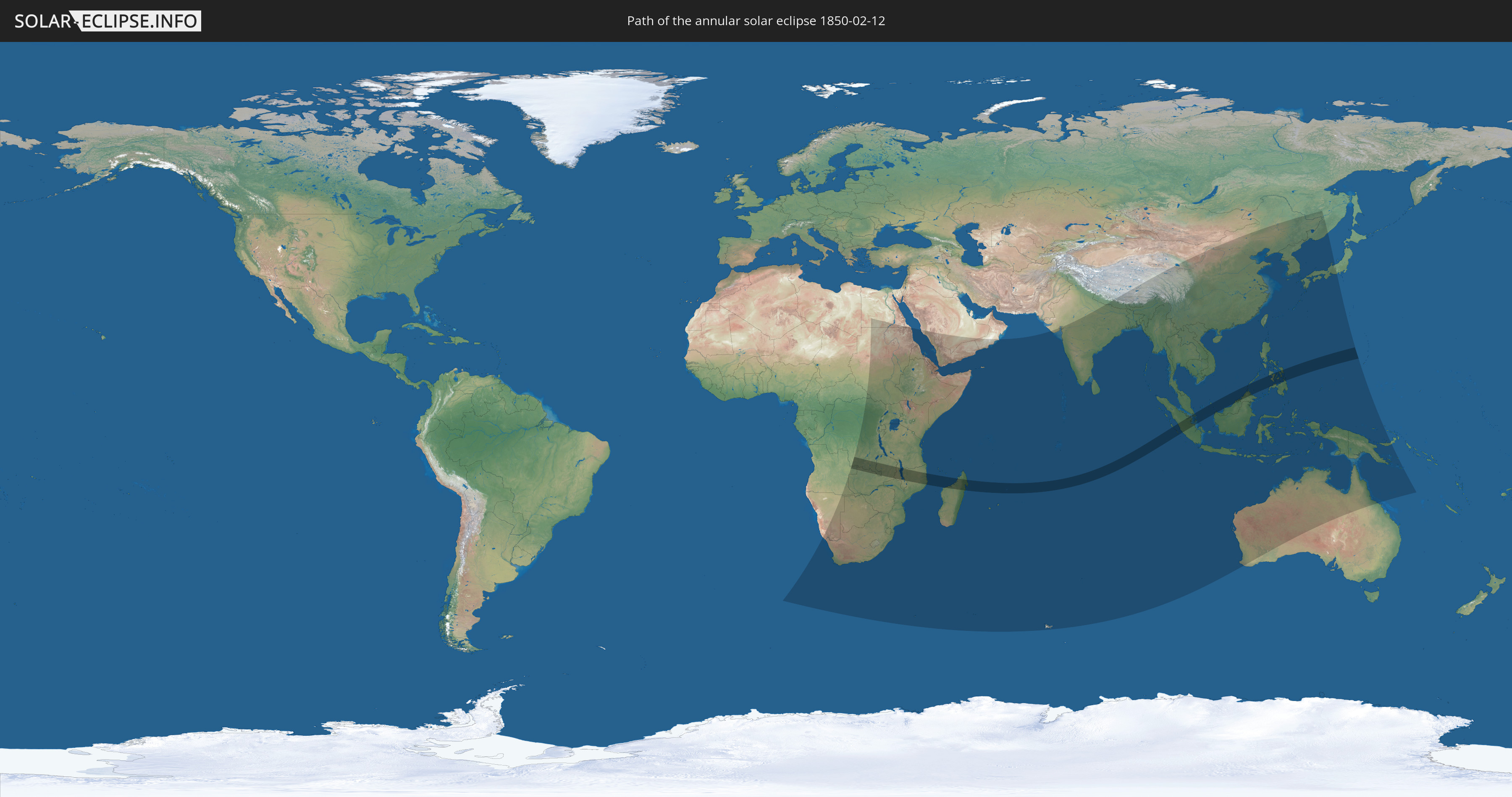
Annular solar eclipse of 02/12/1850
| Day of week: | Tuesday |
| Maximum duration of eclipse: | 08m35s |
| Maximum width of eclipse path: | 245 km |
| Saros cycle: | 128 |
| Coverage: | 93.5% |
| Magnitude: | 0.9345 |
| Gamma: | 0.0503 |
Wo kann man die Sonnenfinsternis vom 02/12/1850 sehen?
Die Sonnenfinsternis am 02/12/1850 kann man in 65 Ländern als partielle Sonnenfinsternis beobachten.
Der Finsternispfad verläuft durch 12 Länder. Nur in diesen Ländern ist sie als annular Sonnenfinsternis zu sehen.
In den folgenden Ländern ist die Sonnenfinsternis annular zu sehen
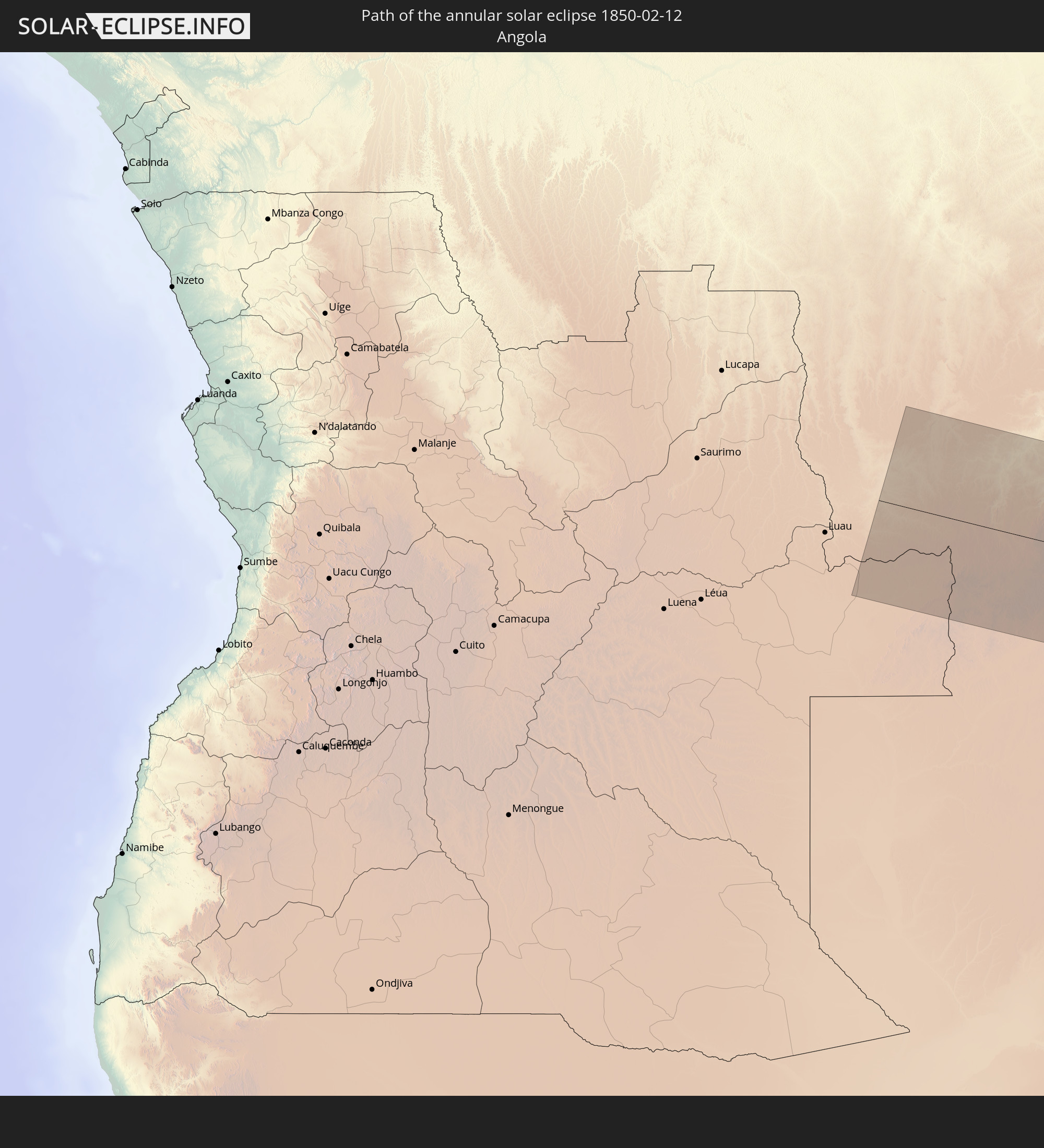 Angola
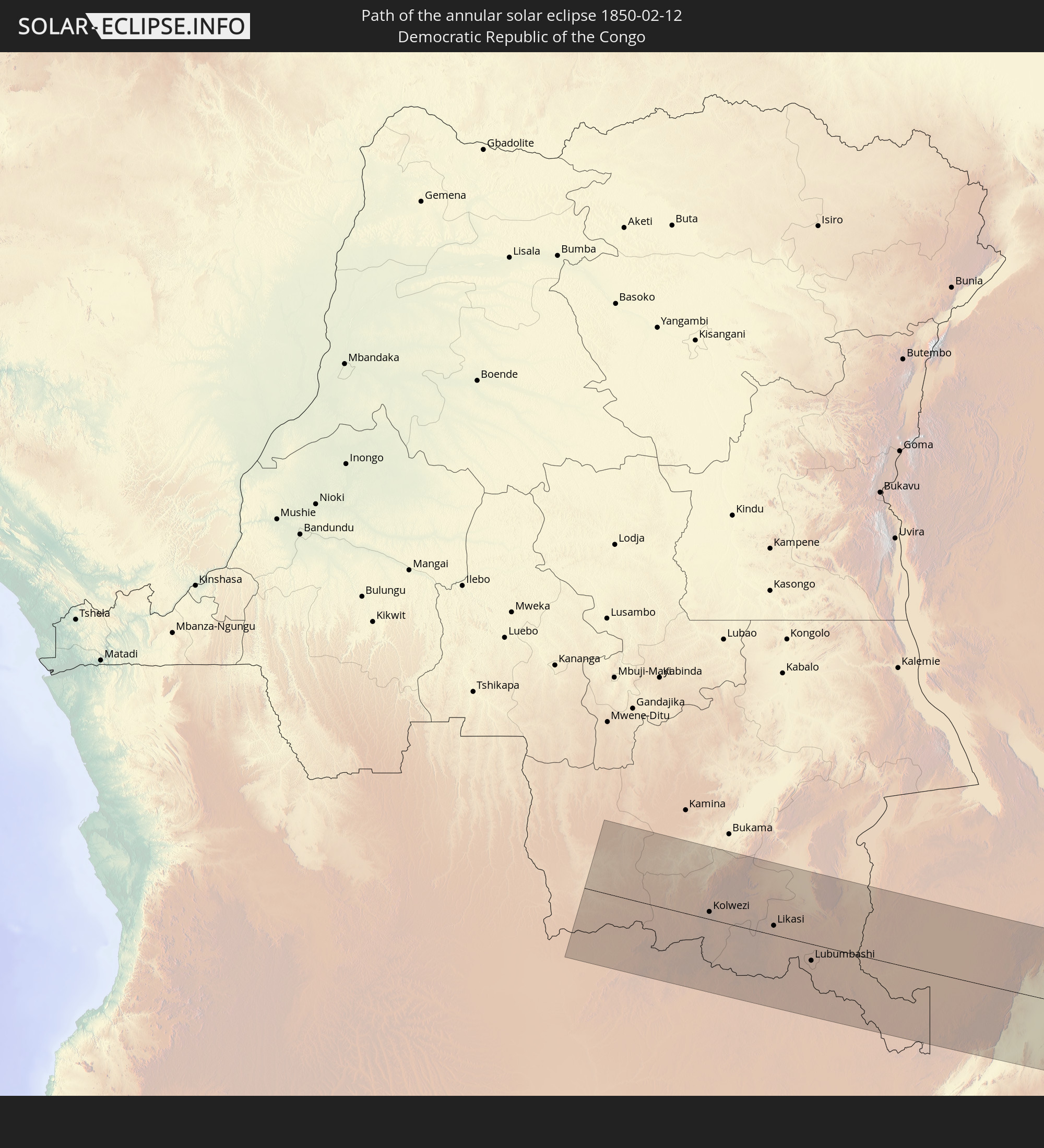 Democratic Republic of the Congo
 Zambia
 Mozambique
 Malawi
 French Southern and Antarctic Lands
 Madagascar
 Mauritius
 Indonesia
 Malaysia
 Brunei
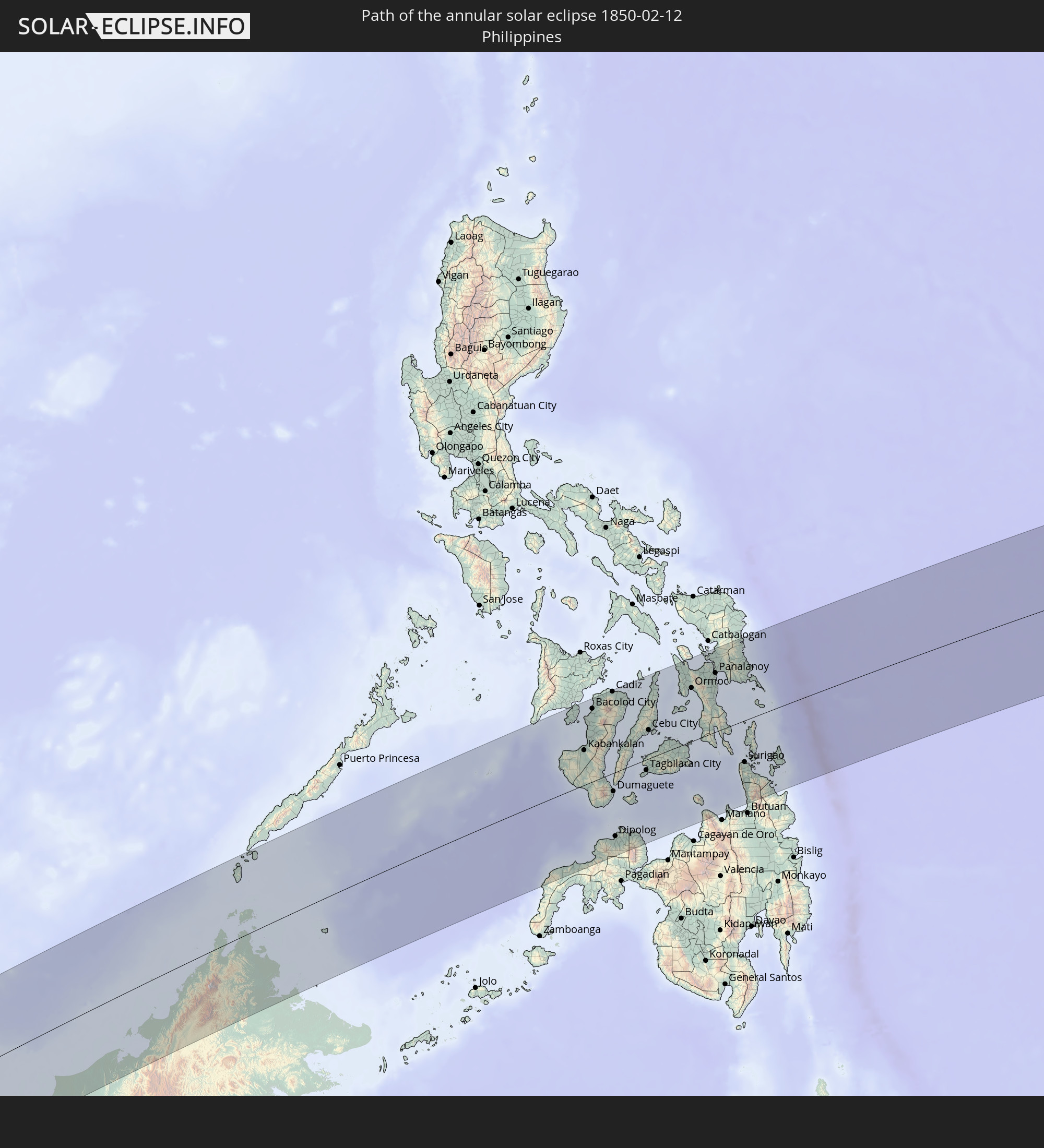 Philippines
In den folgenden Ländern ist die Sonnenfinsternis partiell zu sehen
 Russia
 Angola
 Namibia
 Democratic Republic of the Congo
 Central African Republic
 South Africa
 Botswana
 Sudan
Sudan
 Zambia
 Egypt
Egypt
 Zimbabwe
 Lesotho
 Rwanda
 Burundi
 Tanzania
 Uganda
 Mozambique
 Swaziland
 Malawi
 Ethiopia
 Kenya
Kenya
 Saudi Arabia
 Eritrea
 French Southern and Antarctic Lands
 Somalia
 Djibouti
 Yemen
Yemen
 Madagascar
 Comoros
 Mayotte
 Seychelles
 Oman
Oman
 Réunion
 Mauritius
 India
India
 British Indian Ocean Territory
 Maldives
 China
China
 Sri Lanka
 Nepal
Nepal
 Bangladesh
 Bhutan
 Myanmar
 Indonesia
 Cocos Islands
 Thailand
 Malaysia
 Laos
Laos
 Vietnam
 Cambodia
 Singapore
 Christmas Island
 Australia
 Macau
Macau
 Hong Kong
 Brunei
 Taiwan
 Philippines
 Japan
Japan
 East Timor
 North Korea
 South Korea
 Palau
Palau
 Federated States of Micronesia
 Papua New Guinea
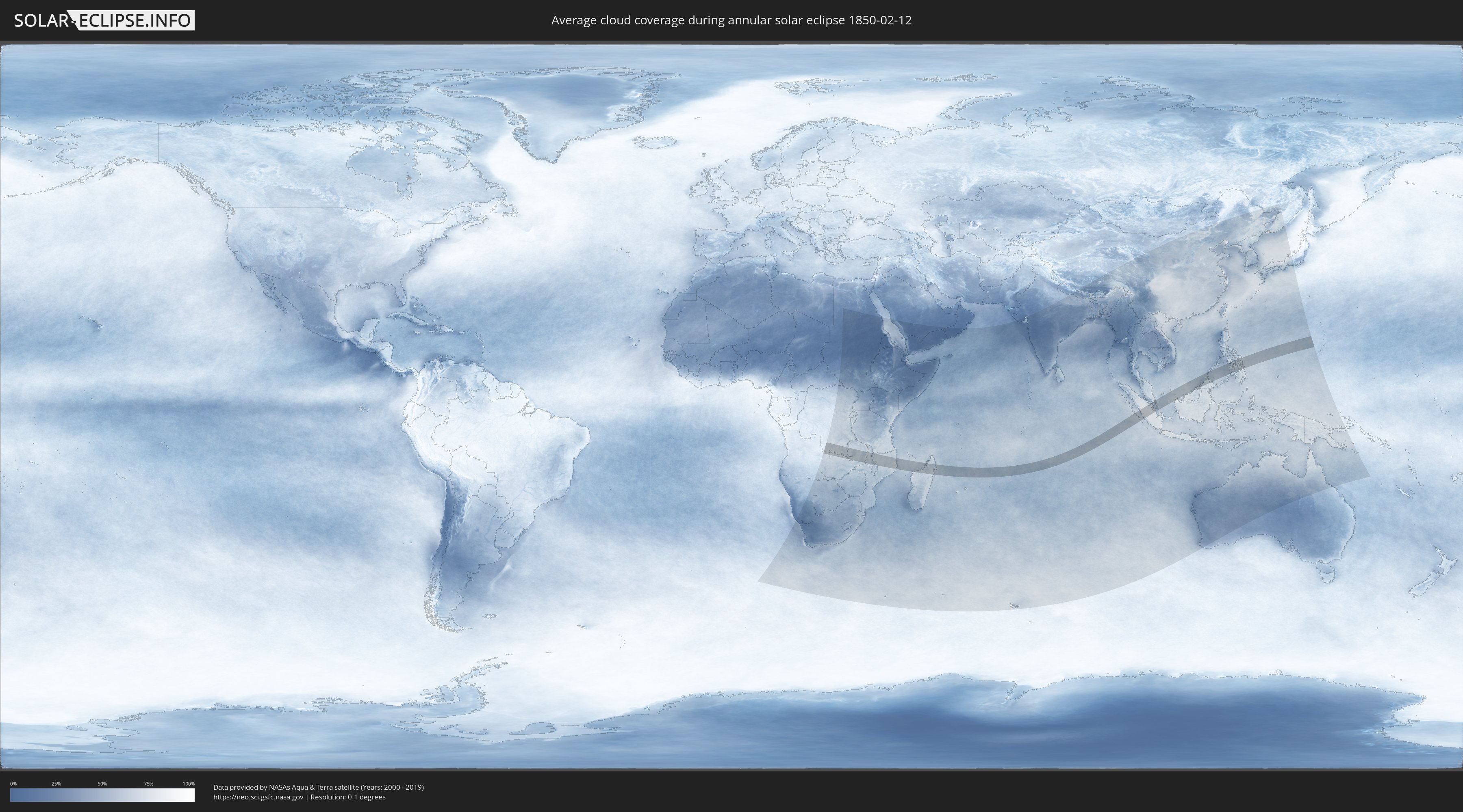
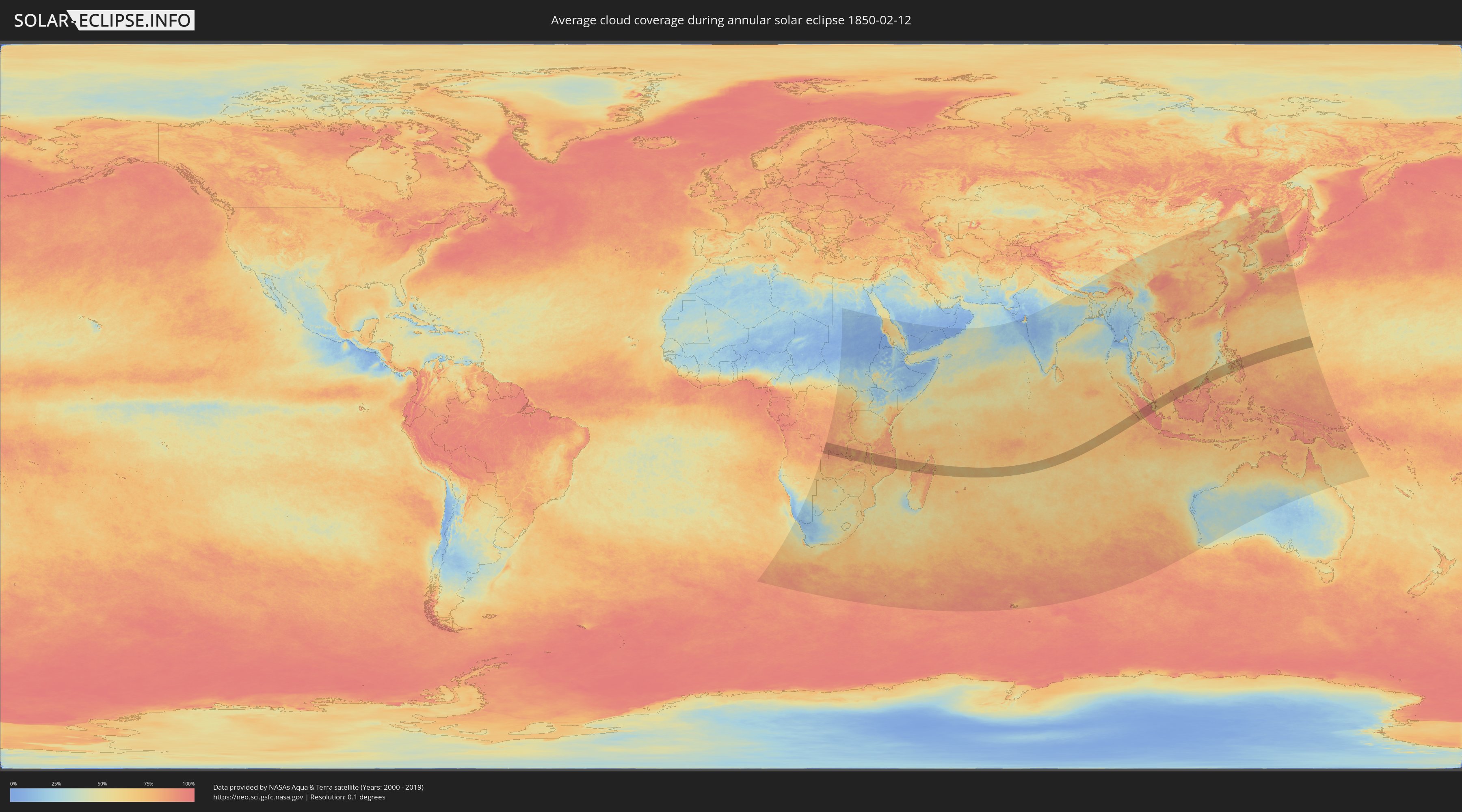
How will be the weather during the annular solar eclipse on 02/12/1850?
Where is the best place to see the annular solar eclipse of 02/12/1850?
The following maps show the average cloud coverage for the day of the annular solar eclipse.
With the help of these maps, it is possible to find the place along the eclipse path, which has the best
chance of a cloudless sky.
Nevertheless, you should consider local circumstances and inform about the weather of your chosen
observation site.
The data is provided by NASAs satellites
AQUA and TERRA.
The cloud maps are averaged over a period of 19 years (2000 - 2019).
Detailed country maps
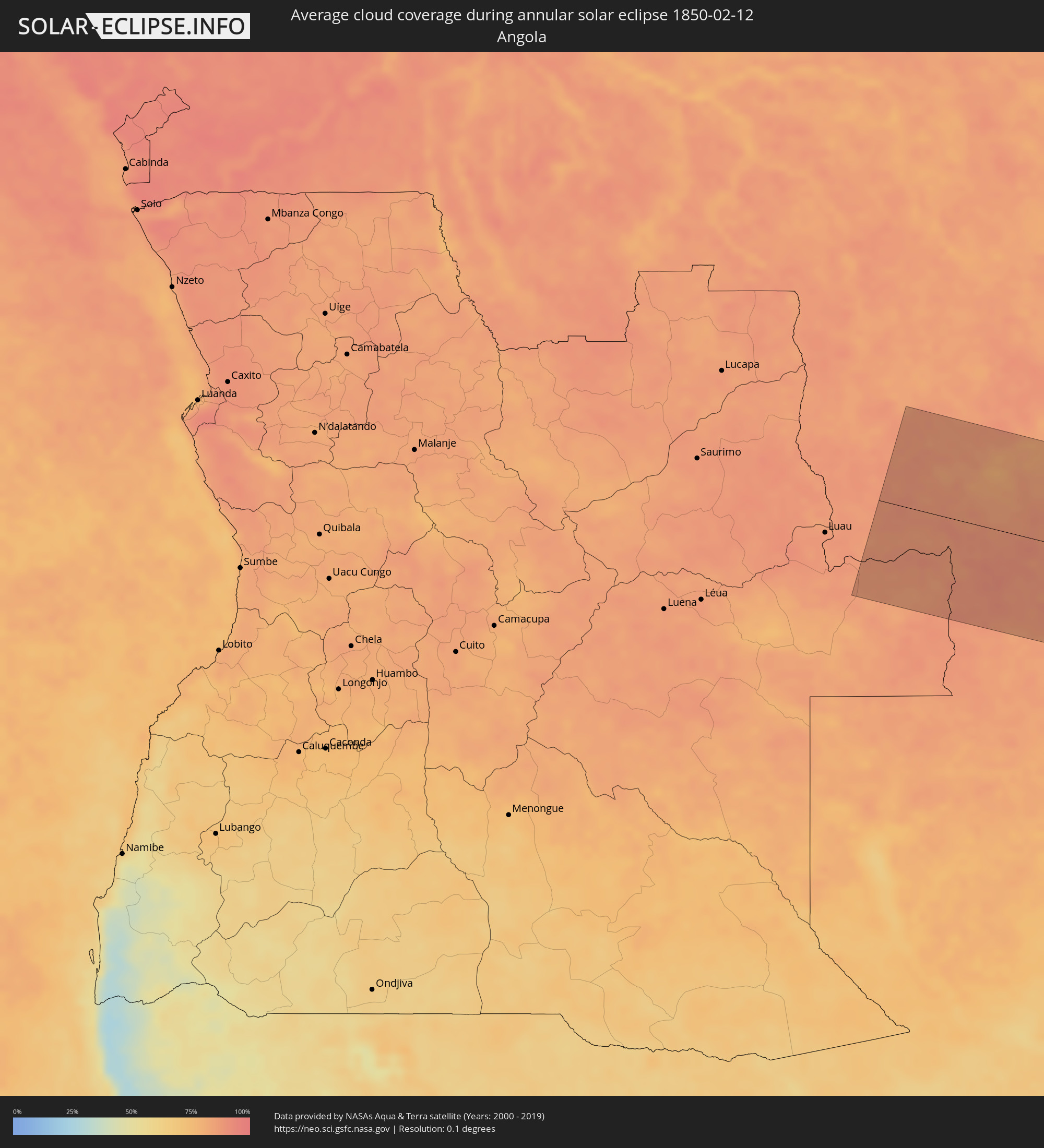 Angola
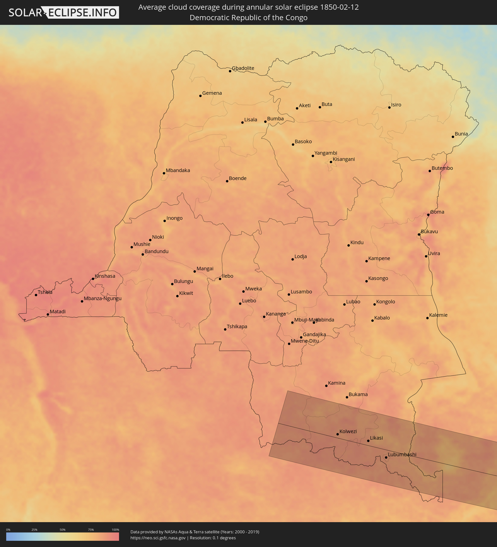 Democratic Republic of the Congo
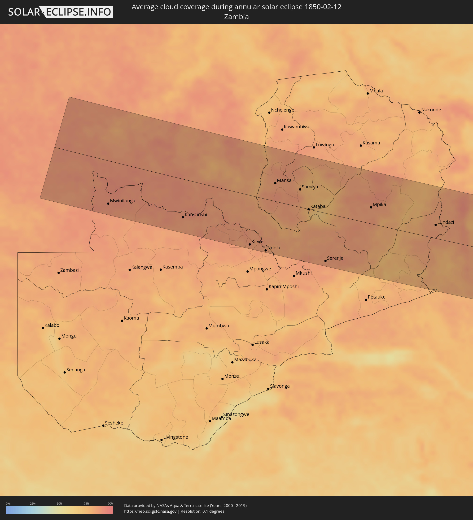 Zambia
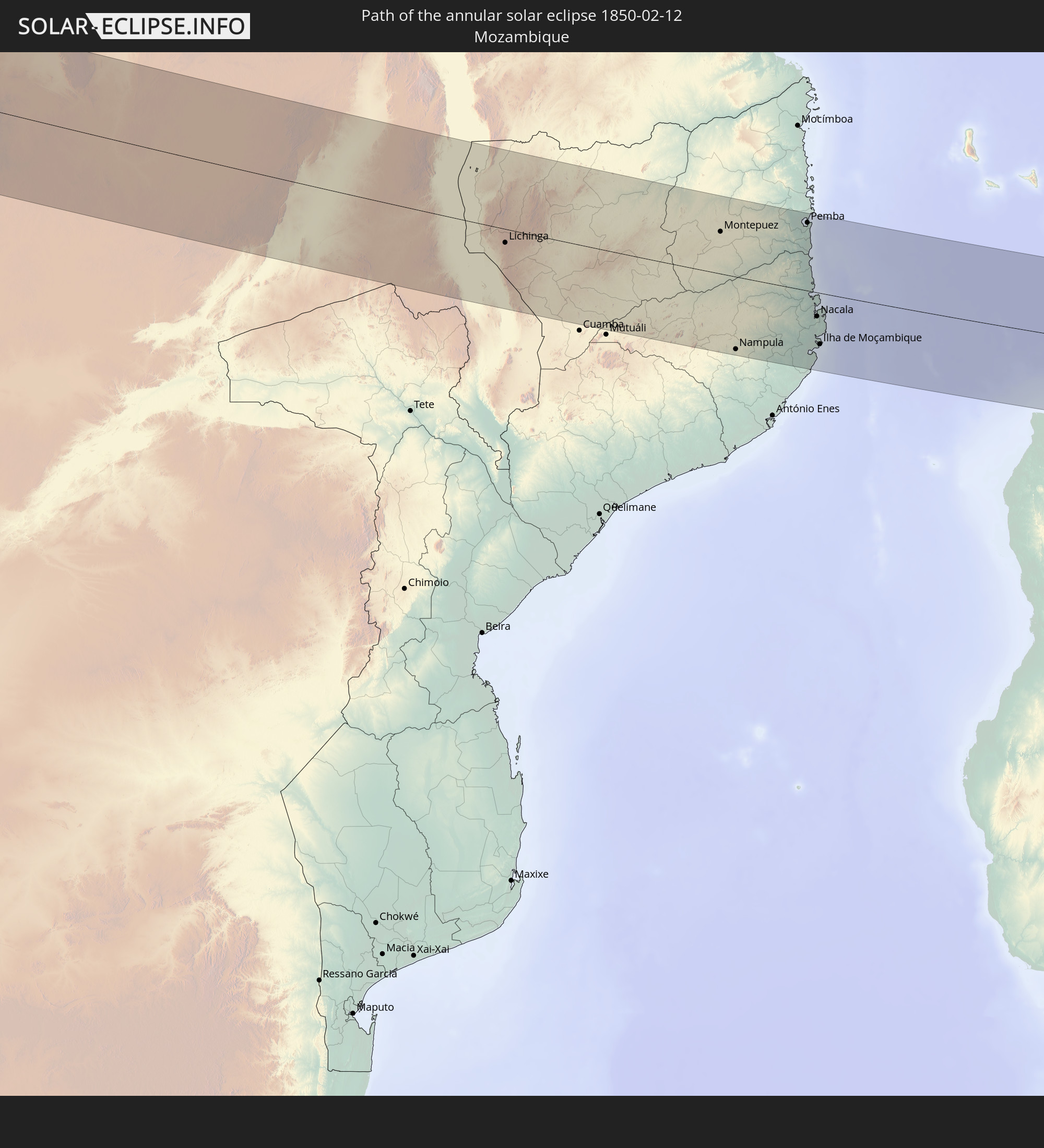
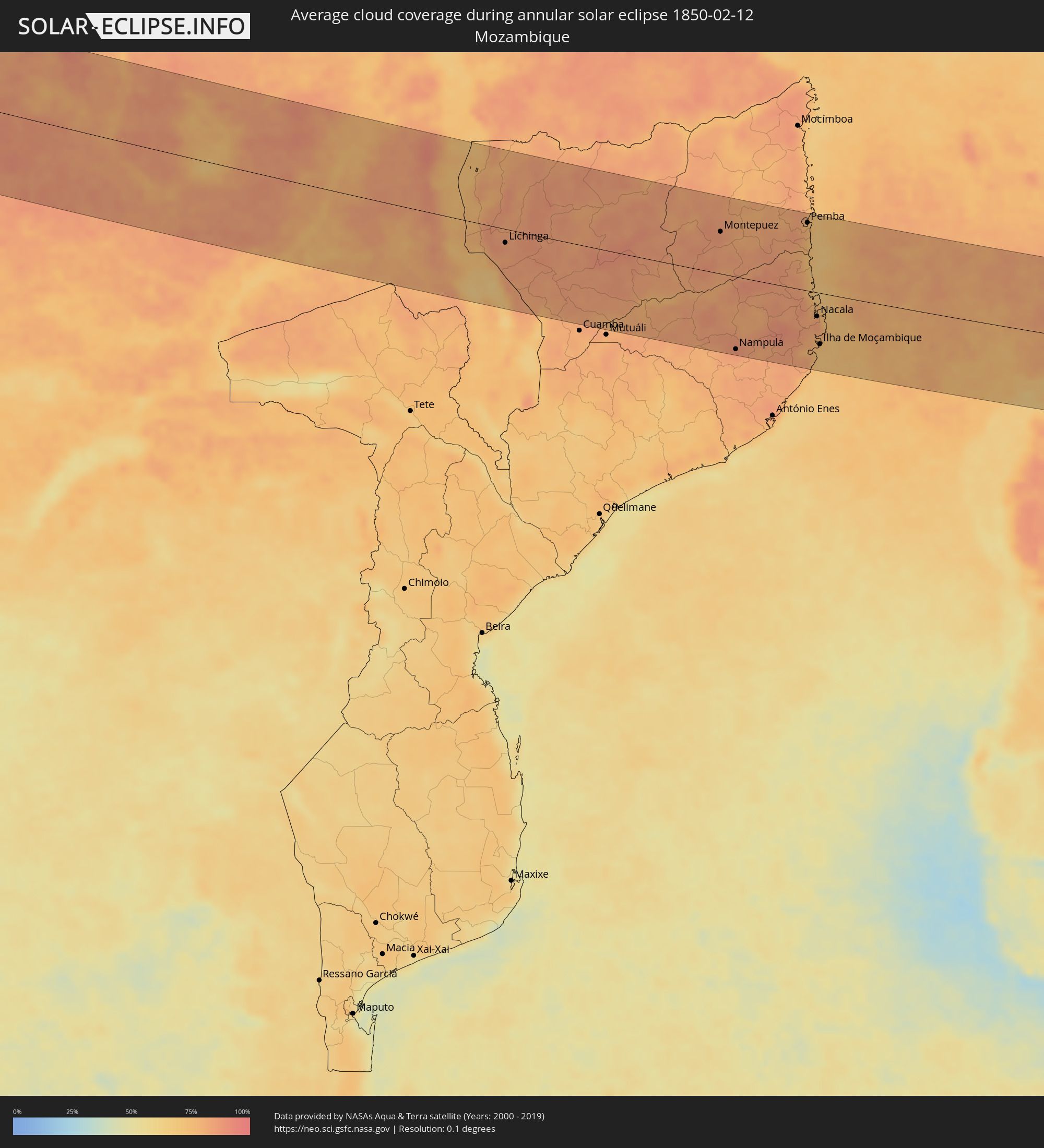 Mozambique
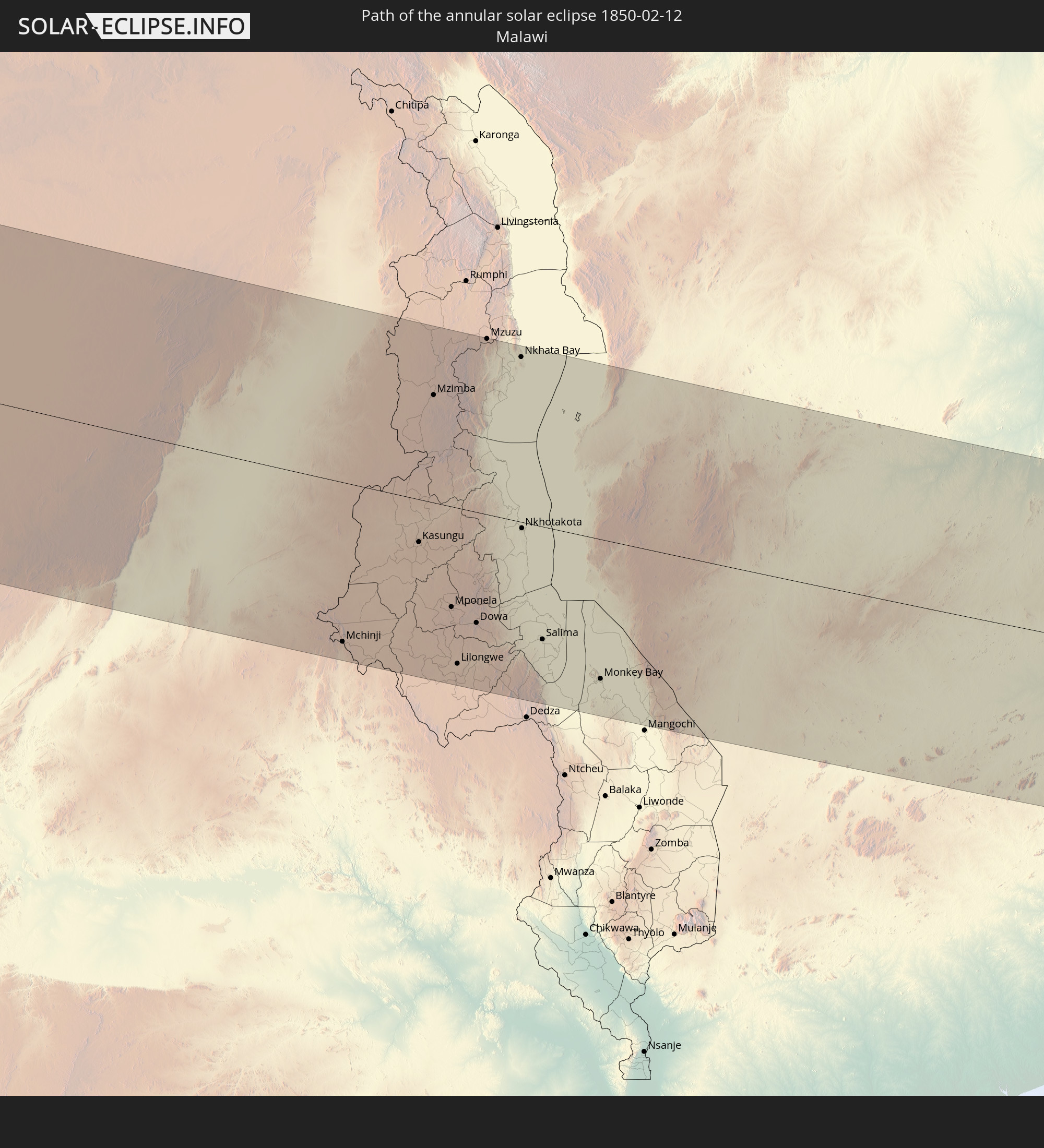
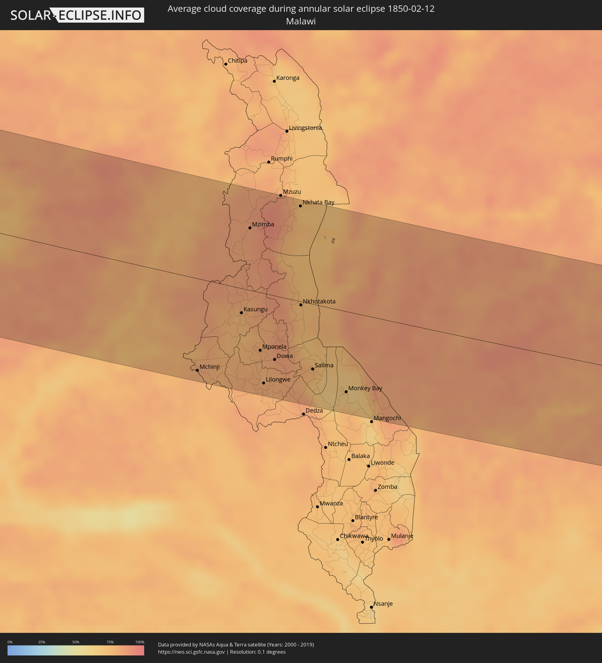 Malawi
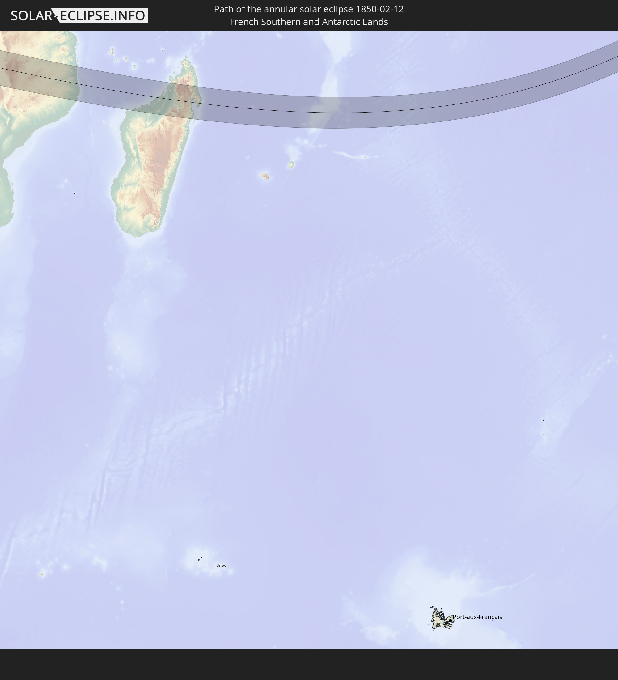
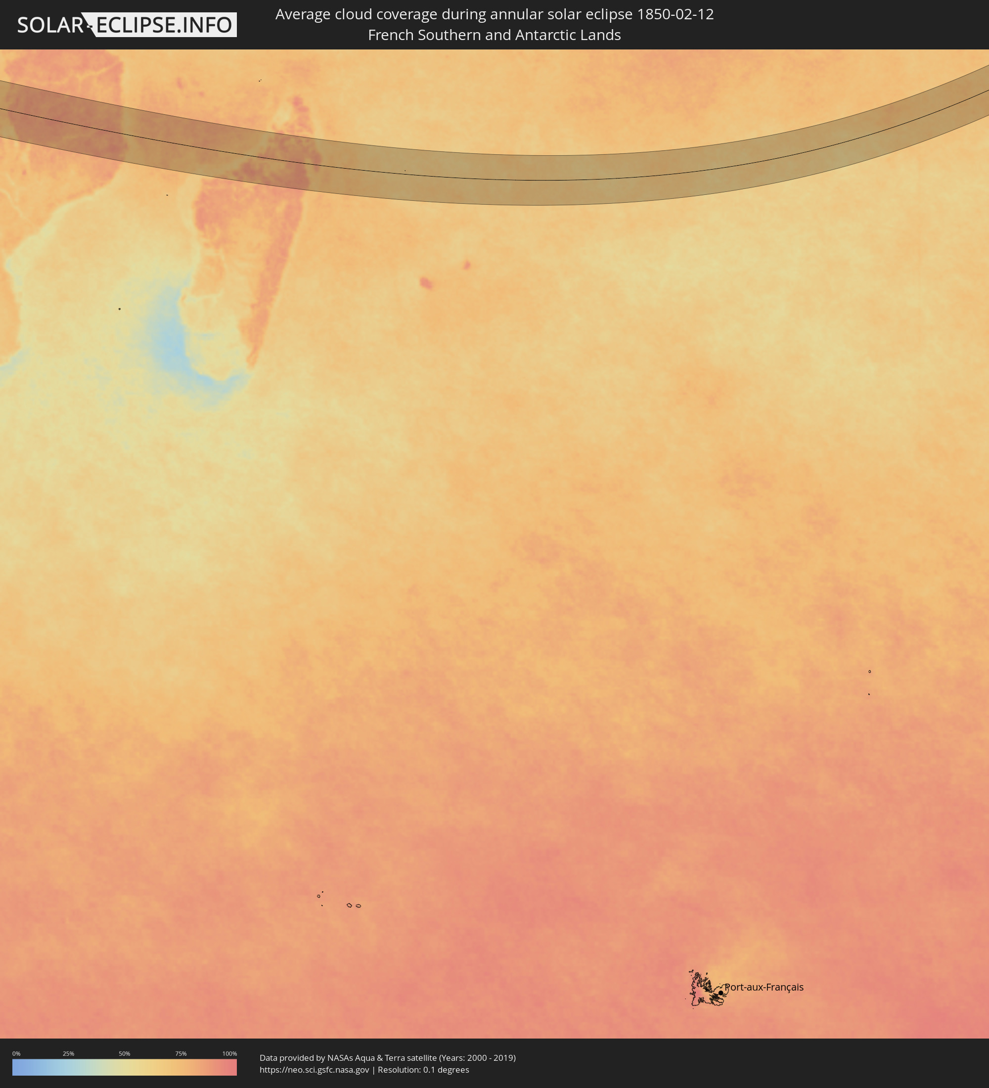 French Southern and Antarctic Lands
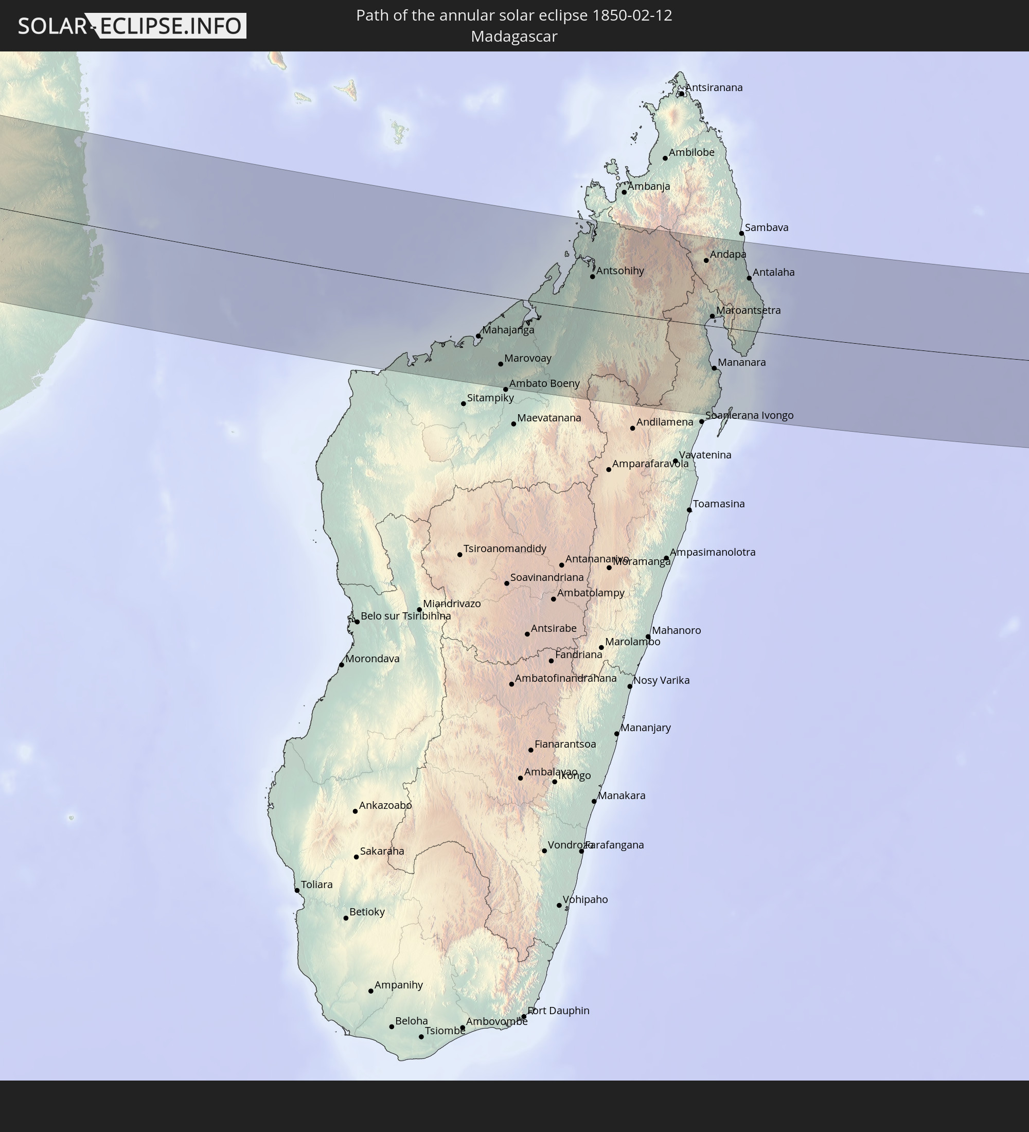
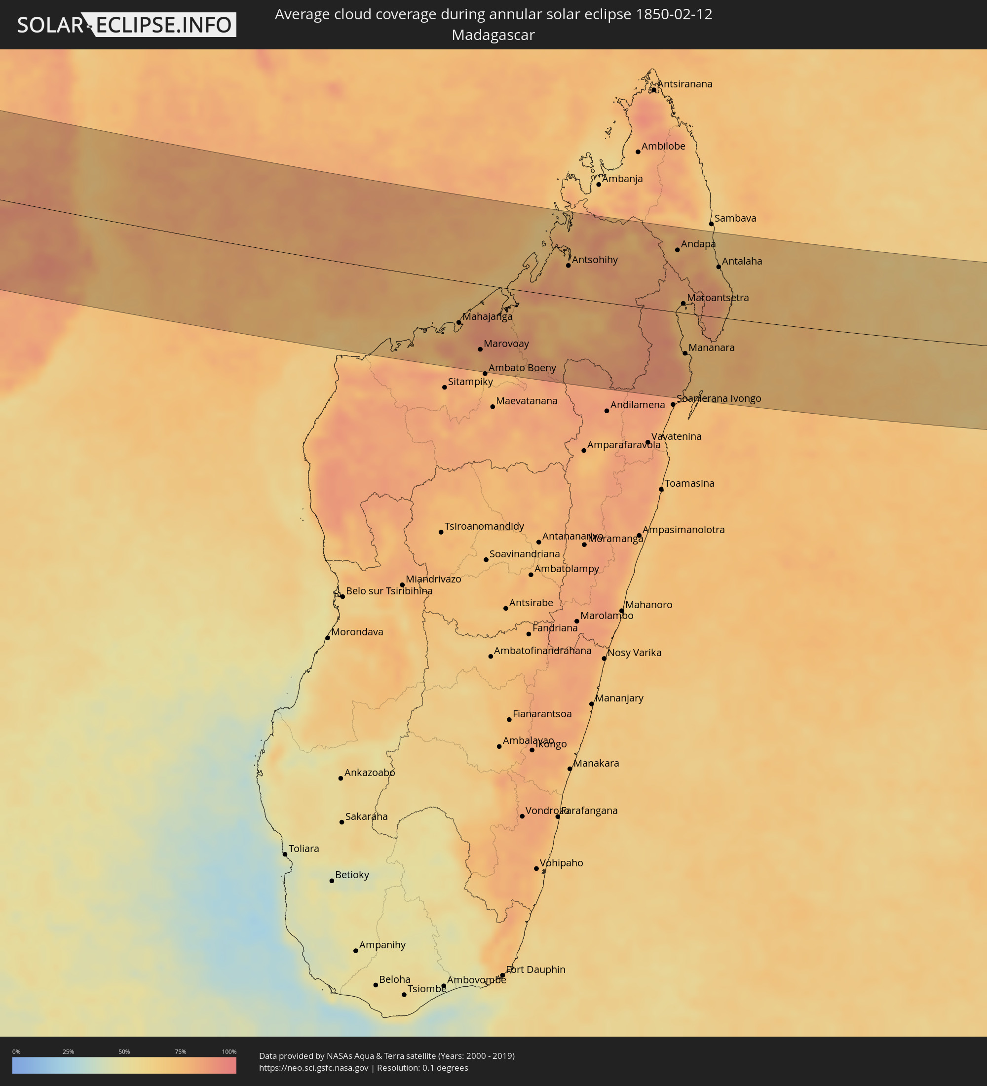 Madagascar
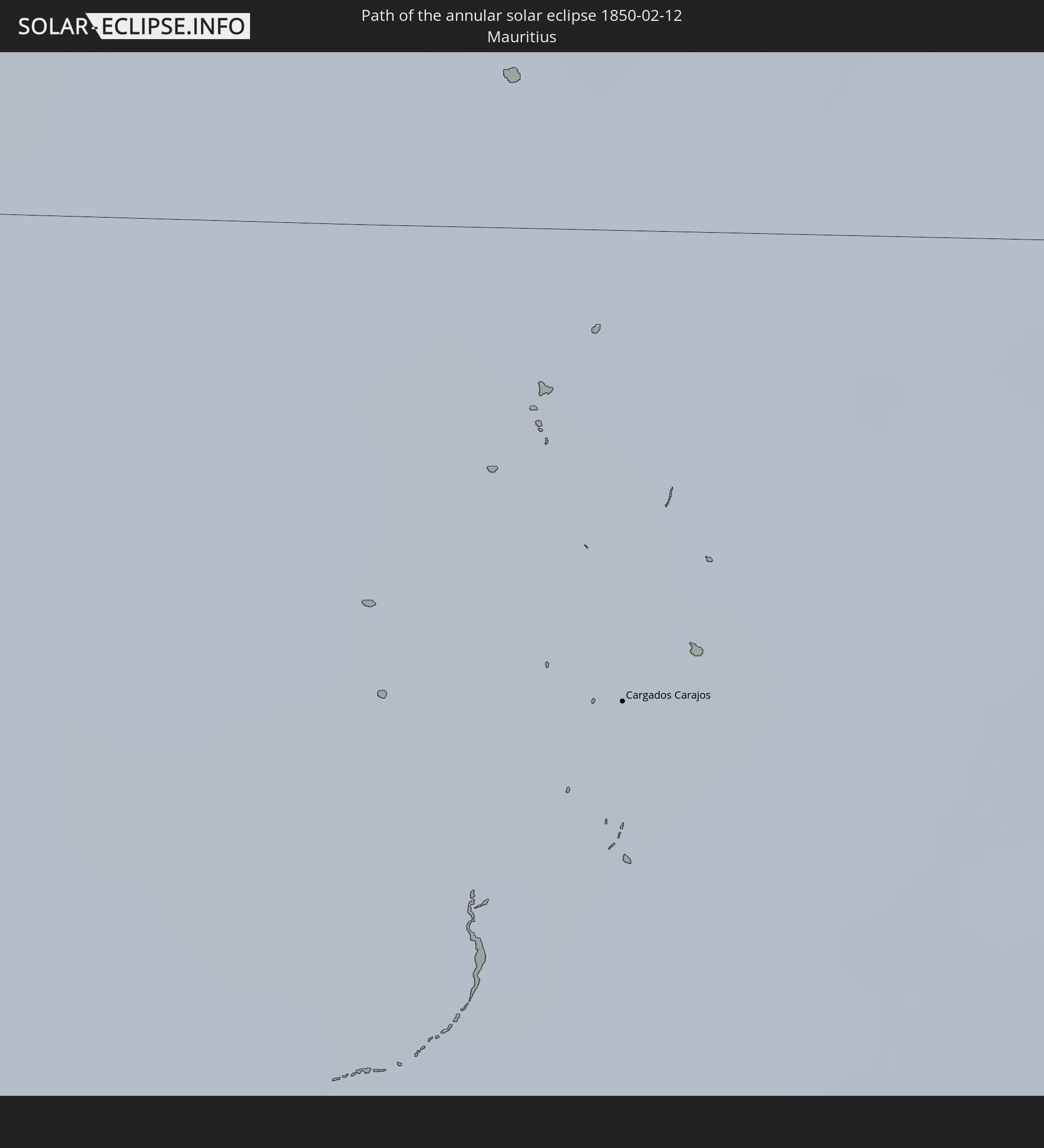
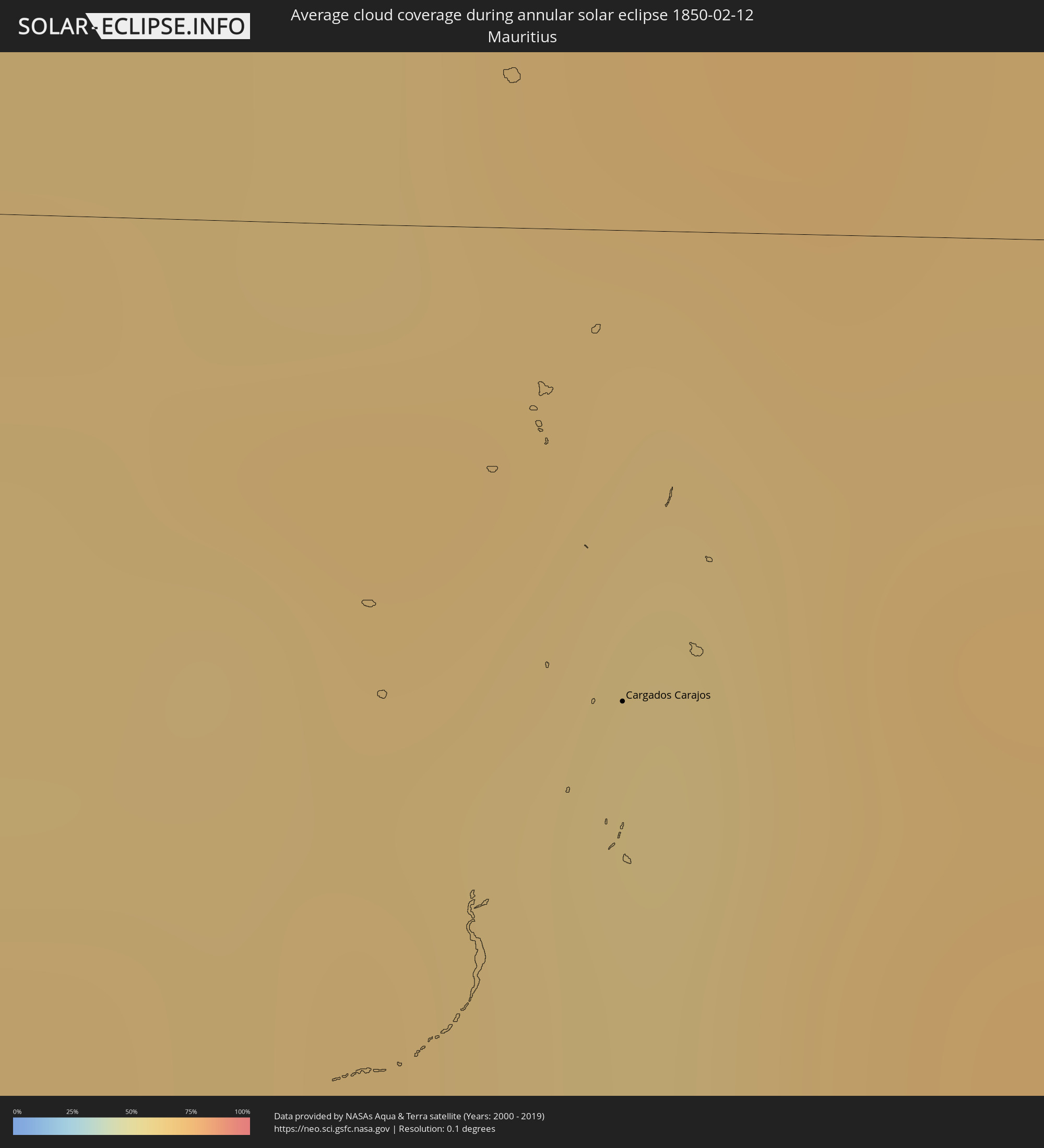 Mauritius
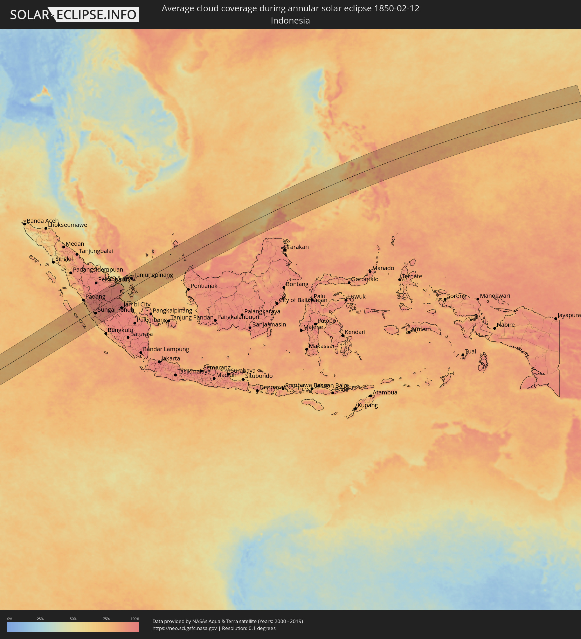 Indonesia
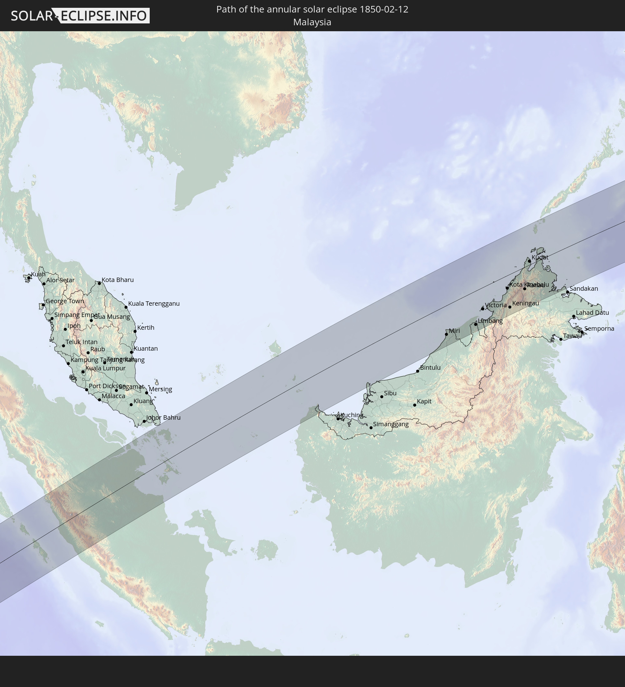
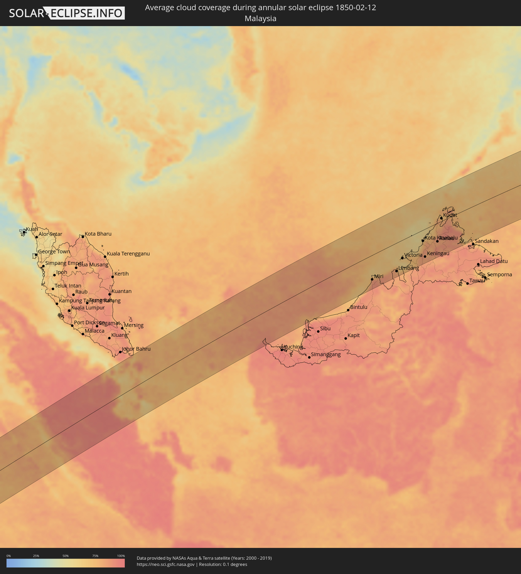 Malaysia
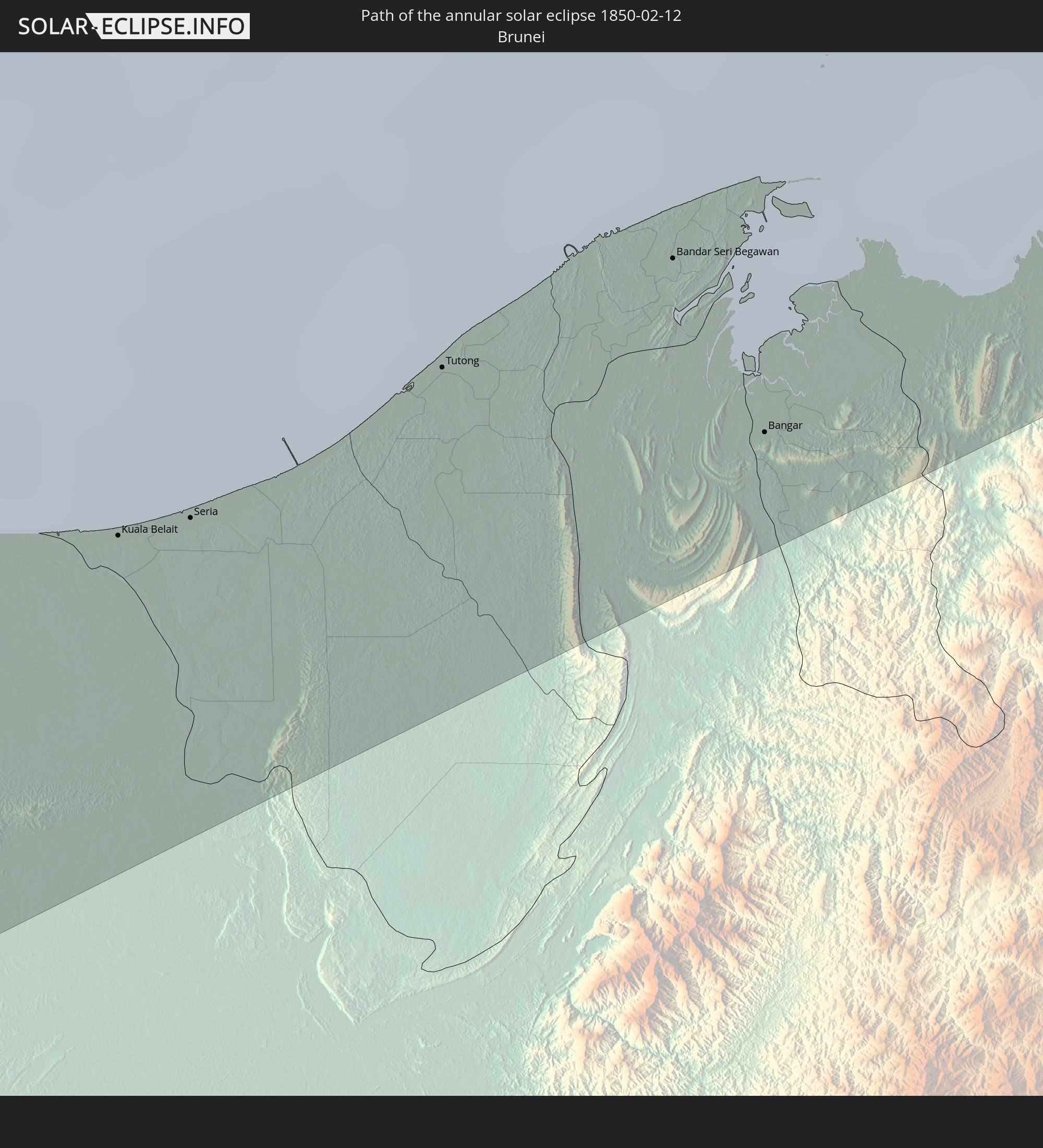
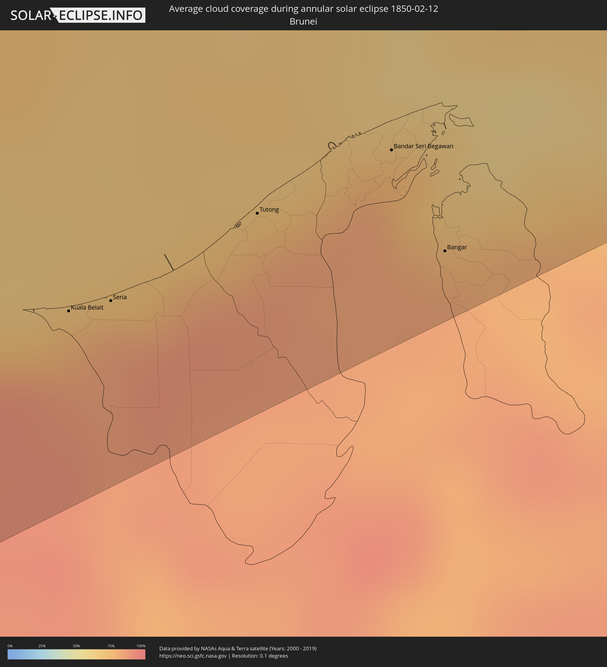 Brunei
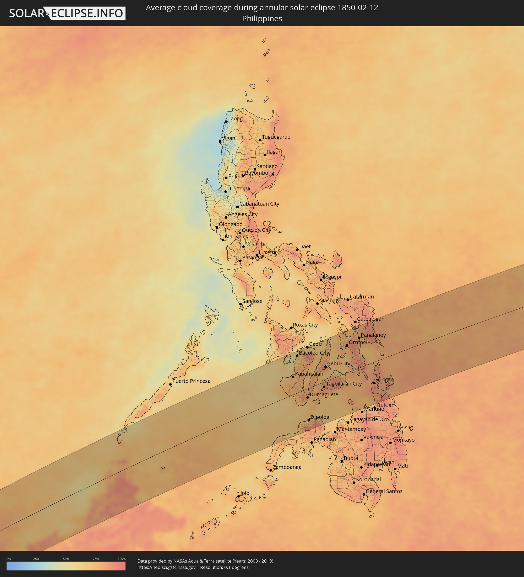 Philippines
Cities inside the path of the eclipse
The following table shows all locations with a population of more than 5,000 inside the eclipse path. Cities which have more than 100,000 inhabitants are marked bold. A click at the locations opens a detailed map.
| City | Type | Eclipse duration | Local time of max. eclipse | Distance to central line | Ø Cloud coverage |
|
Mwinilunga, North-Western
|
annular | - | 06:42:56 UTC+02:10 | 122 km | 89% |
|
Kolwezi, Katanga
|
annular | - | 06:42:47 UTC+02:10 | 15 km | 86% |
|
Solwezi, North-Western
|
annular | - | 06:43:07 UTC+02:10 | 118 km | 85% |
|
Kansanshi, North-Western
|
annular | - | 06:43:07 UTC+02:10 | 109 km | 86% |
|
Kambove, Katanga
|
annular | - | 06:42:54 UTC+02:10 | 28 km | 86% |
|
Likasi, Katanga
|
annular | - | 06:42:56 UTC+02:10 | 19 km | 84% |
|
Kipushi, Katanga
|
annular | - | 06:43:08 UTC+02:10 | 52 km | 84% |
|
Lubumbashi, Katanga
|
annular | - | 06:43:08 UTC+02:10 | 35 km | 85% |
|
Kalulushi, Copperbelt
|
annular | - | 06:43:29 UTC+02:10 | 147 km | 83% |
|
Kitwe, Copperbelt
|
annular | - | 06:43:29 UTC+02:10 | 140 km | 84% |
|
Mufulira, Copperbelt
|
annular | - | 06:43:26 UTC+02:10 | 112 km | 86% |
|
Ndola, Copperbelt
|
annular | - | 06:43:36 UTC+02:10 | 146 km | 82% |
|
Mansa, Luapula
|
annular | - | 06:43:17 UTC+02:10 | 51 km | 84% |
|
Samfya, Luapula
|
annular | - | 06:43:27 UTC+02:10 | 50 km | 79% |
|
Kataba, Copperbelt
|
annular | - | 06:43:35 UTC+02:10 | 1 km | 74% |
|
Serenje, Central
|
annular | - | 06:43:59 UTC+02:10 | 136 km | 85% |
|
Mpika, Muchinga Province
|
annular | - | 06:44:01 UTC+02:10 | 46 km | 85% |
|
Mchinji, Central Region
|
annular | - | 06:44:55 UTC+02:10 | 133 km | 78% |
|
Lundazi, Eastern
|
annular | - | 06:44:41 UTC+02:10 | 38 km | 84% |
|
Kasungu, Central Region
|
annular | - | 06:44:58 UTC+02:10 | 36 km | 77% |
|
Mzimba, Northern Region
|
annular | - | 06:44:46 UTC+02:10 | 90 km | 84% |
|
Mponela, Central Region
|
annular | - | 06:45:11 UTC+02:10 | 84 km | 79% |
|
Lilongwe, Central Region
|
annular | - | 06:45:19 UTC+02:10 | 130 km | 79% |
|
Ntchisi, Central Region
|
annular | - | 06:45:15 UTC+02:10 | 79 km | 83% |
|
Dowa, Central Region
|
annular | - | 06:45:17 UTC+02:10 | 92 km | 79% |
|
Mzuzu, Northern Region
|
annular | - | 06:44:52 UTC+02:10 | 147 km | 88% |
|
Nkhata Bay, Northern Region
|
annular | - | 06:45:00 UTC+02:10 | 138 km | 71% |
|
Nkhotakota, Central Region
|
annular | - | 06:45:16 UTC+02:10 | 5 km | 75% |
|
Salima, Central Region
|
annular | - | 06:45:32 UTC+02:10 | 94 km | 73% |
|
Monkey Bay, Southern Region
|
annular | - | 06:45:49 UTC+02:10 | 116 km | 69% |
|
Lichinga, Niassa
|
annular | - | 06:45:47 UTC+02:10 | 25 km | 86% |
|
Montepuez, Cabo Delgado
|
annular | - | 06:47:52 UTC+02:10 | 78 km | 86% |
|
Nampula, Nampula
|
annular | - | 06:48:32 UTC+02:10 | 134 km | 87% |
|
Pemba, Cabo Delgado
|
annular | - | 06:48:55 UTC+02:10 | 126 km | 79% |
|
Nacala, Nampula
|
annular | - | 06:49:23 UTC+02:10 | 44 km | 85% |
|
Ilha de Moçambique, Nampula
|
annular | - | 06:49:33 UTC+02:10 | 95 km | 74% |
|
Mahajanga, Boeny
|
annular | - | 07:11:45 UTC+02:27 | 68 km | 77% |
|
Marovoay, Boeny
|
annular | - | 07:12:13 UTC+02:27 | 106 km | 76% |
|
Antsohihy, Sofia
|
annular | - | 07:13:29 UTC+02:27 | 51 km | 80% |
|
Bealanana, Sofia
|
annular | - | 07:14:22 UTC+02:27 | 99 km | 74% |
|
Antsirabe Afovoany, Sofia
|
annular | - | 07:14:55 UTC+02:27 | 53 km | 85% |
|
Andapa, Sava
|
annular | - | 07:15:34 UTC+02:27 | 100 km | 83% |
|
Maroantsetra, Analanjirofo
|
annular | - | 07:15:48 UTC+02:27 | 15 km | 71% |
|
Mananara, Analanjirofo
|
annular | - | 07:15:59 UTC+02:27 | 66 km | 76% |
|
Antakotako, Analanjirofo
|
annular | - | 07:15:52 UTC+02:27 | 29 km | 74% |
|
Ampahana, Sava
|
annular | - | 07:16:20 UTC+02:27 | 97 km | 70% |
|
Antalaha, Sava
|
annular | - | 07:16:27 UTC+02:27 | 81 km | 69% |
|
Cargados Carajos, Cargados Carajos
|
annular | - | 08:55:24 UTC+03:50 | 30 km | 61% |
|
Sijunjung, West Sumatra
|
annular | - | 14:40:54 UTC+07:07 | 123 km | 91% |
|
Sungai Penuh, Jambi
|
annular | - | 14:39:40 UTC+07:07 | 29 km | 88% |
|
Bejubang Dua, Jambi
|
annular | - | 14:44:26 UTC+07:07 | 117 km | 94% |
|
Kuala Tungkal, Jambi
|
annular | - | 14:46:15 UTC+07:07 | 32 km | 85% |
|
Mendaha, Jambi
|
annular | - | 14:46:14 UTC+07:07 | 59 km | 92% |
|
Jambi City, Jambi
|
annular | - | 14:45:23 UTC+07:07 | 116 km | 95% |
|
Simpang, Jambi
|
annular | - | 14:46:55 UTC+07:07 | 112 km | 92% |
|
Tanjungpinang, Riau Islands
|
annular | - | 14:50:55 UTC+07:07 | 76 km | 90% |
|
Kijang, Riau Islands
|
annular | - | 14:51:15 UTC+07:07 | 64 km | 87% |
|
Miri, Sarawak
|
annular | - | 15:25:20 UTC+07:21 | 98 km | 86% |
|
Kuala Belait, Belait
|
annular | - | 15:44:08 UTC+07:39 | 93 km | 78% |
|
Seria, Belait
|
annular | - | 15:44:17 UTC+07:39 | 95 km | 83% |
|
Tutong, Tutong
|
annular | - | 15:44:54 UTC+07:39 | 92 km | 82% |
|
Bandar Seri Begawan, Brunei and Muara
|
annular | - | 15:45:26 UTC+07:39 | 93 km | 82% |
|
Limbang, Sarawak
|
annular | - | 15:26:58 UTC+07:21 | 114 km | 80% |
|
Bangar, Temburong
|
annular | - | 15:45:21 UTC+07:39 | 121 km | 82% |
|
Victoria, Labuan
|
annular | - | 15:27:48 UTC+07:21 | 74 km | 67% |
|
Bandar Labuan, Sabah
|
annular | - | 15:27:50 UTC+07:21 | 74 km | 67% |
|
Beaufort, Sabah
|
annular | - | 15:28:29 UTC+07:21 | 91 km | 75% |
|
Papar, Sabah
|
annular | - | 15:29:05 UTC+07:21 | 62 km | 66% |
|
Kinarut, Sabah
|
annular | - | 15:29:18 UTC+07:21 | 58 km | 70% |
|
Putatan, Sabah
|
annular | - | 15:29:24 UTC+07:21 | 49 km | 78% |
|
Kota Kinabalu, Sabah
|
annular | - | 15:29:28 UTC+07:21 | 44 km | 77% |
|
Donggongon, Sabah
|
annular | - | 15:29:26 UTC+07:21 | 52 km | 78% |
|
Keningau, Sabah
|
annular | - | 15:28:58 UTC+07:21 | 112 km | 81% |
|
Kota Belud, Sabah
|
annular | - | 15:30:14 UTC+07:21 | 24 km | 67% |
|
Ranau, Sabah
|
annular | - | 15:30:08 UTC+07:21 | 75 km | 83% |
|
Kudat, Sabah
|
annular | - | 15:31:09 UTC+07:21 | 11 km | 79% |
|
Kabankalan, Western Visayas
|
annular | - | 16:17:44 UTC+08:00 | 59 km | 76% |
|
Bago City, Western Visayas
|
annular | - | 16:18:05 UTC+08:00 | 115 km | 60% |
|
Hinigaran, Western Visayas
|
annular | - | 16:17:56 UTC+08:00 | 87 km | 74% |
|
La Carlota, Western Visayas
|
annular | - | 16:18:05 UTC+08:00 | 100 km | 73% |
|
Bacolod City, Western Visayas
|
annular | - | 16:18:15 UTC+08:00 | 124 km | 72% |
|
Bais, Central Visayas
|
annular | - | 16:17:44 UTC+08:00 | 6 km | 74% |
|
Canlaon, Central Visayas
|
annular | - | 16:18:17 UTC+08:00 | 83 km | 78% |
|
Cadiz, Western Visayas
|
annular | - | 16:18:39 UTC+08:00 | 138 km | 87% |
|
Dumaguete, Central Visayas
|
annular | - | 16:17:42 UTC+08:00 | 31 km | 73% |
|
Dipolog, Zamboanga Peninsula
|
annular | - | 16:17:14 UTC+08:00 | 109 km | 73% |
|
Ualog, Western Visayas
|
annular | - | 16:18:31 UTC+08:00 | 96 km | 80% |
|
Toledo, Central Visayas
|
annular | - | 16:18:35 UTC+08:00 | 65 km | 74% |
|
Carcar, Central Visayas
|
annular | - | 16:18:26 UTC+08:00 | 37 km | 75% |
|
Oroquieta, Northern Mindanao
|
annular | - | 16:17:33 UTC+08:00 | 137 km | 77% |
|
Tagbilaran City, Central Visayas
|
annular | - | 16:18:19 UTC+08:00 | 18 km | 85% |
|
Cebu City, Central Visayas
|
annular | - | 16:18:44 UTC+08:00 | 49 km | 80% |
|
Danao, Central Visayas
|
annular | - | 16:18:57 UTC+08:00 | 64 km | 72% |
|
Ormoc, Eastern Visayas
|
annular | - | 16:19:37 UTC+08:00 | 91 km | 78% |
|
Panalanoy, Eastern Visayas
|
annular | - | 16:20:01 UTC+08:00 | 100 km | 79% |
|
Surigao, Caraga
|
annular | - | 16:19:32 UTC+08:00 | 71 km | 85% |