Total solar eclipse of 08/07/1869
| Day of week: | Saturday |
| Maximum duration of eclipse: | 03m48s |
| Maximum width of eclipse path: | 254 km |
| Saros cycle: | 143 |
| Coverage: | 100% |
| Magnitude: | 1.0551 |
| Gamma: | 0.696 |
Wo kann man die Sonnenfinsternis vom 08/07/1869 sehen?
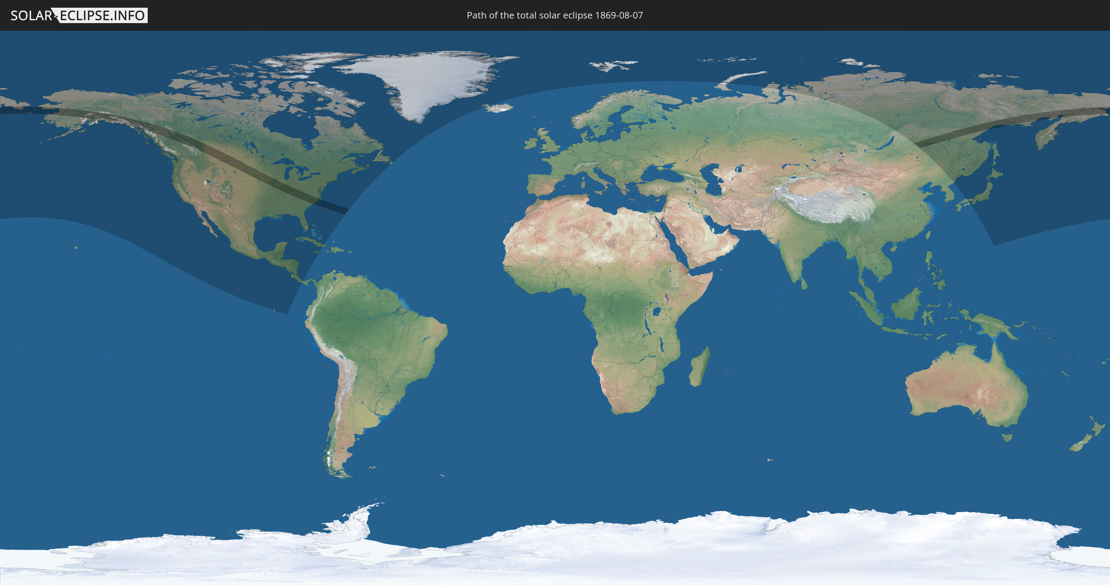
Die Sonnenfinsternis am 08/07/1869 kann man in 24 Ländern als partielle Sonnenfinsternis beobachten.
Der Finsternispfad verläuft durch 4 Länder. Nur in diesen Ländern ist sie als total Sonnenfinsternis zu sehen.
In den folgenden Ländern ist die Sonnenfinsternis total zu sehen
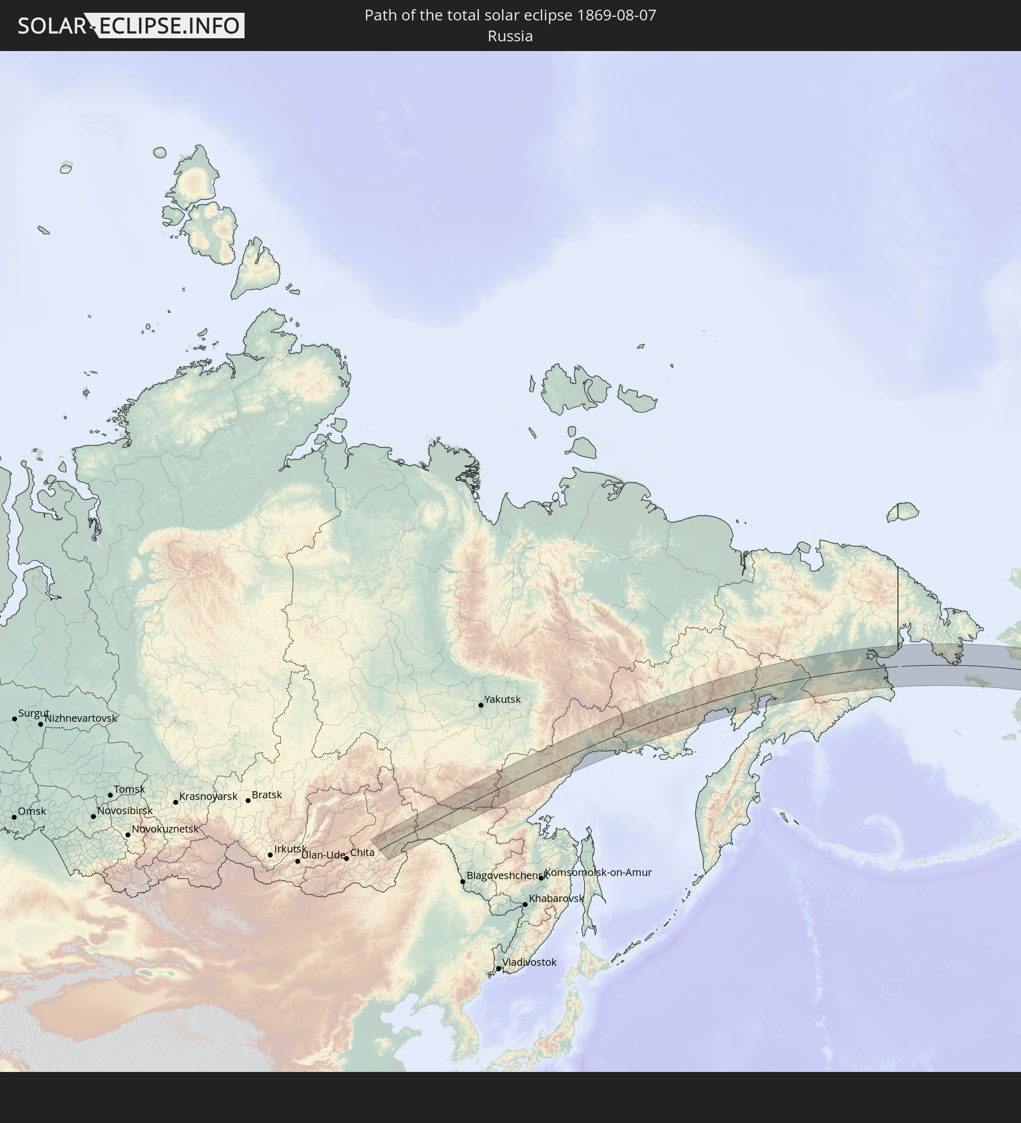 Russia
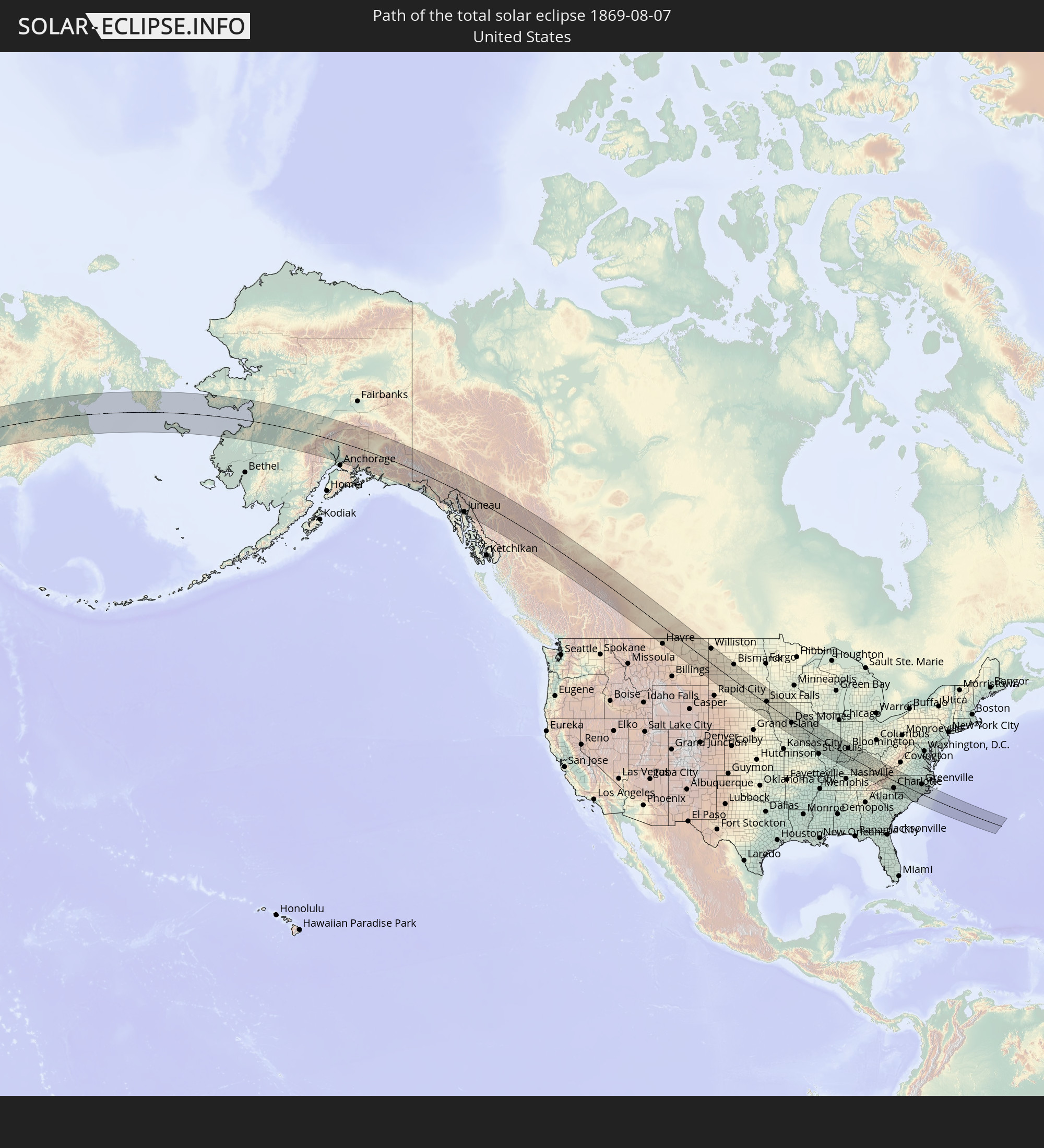 United States
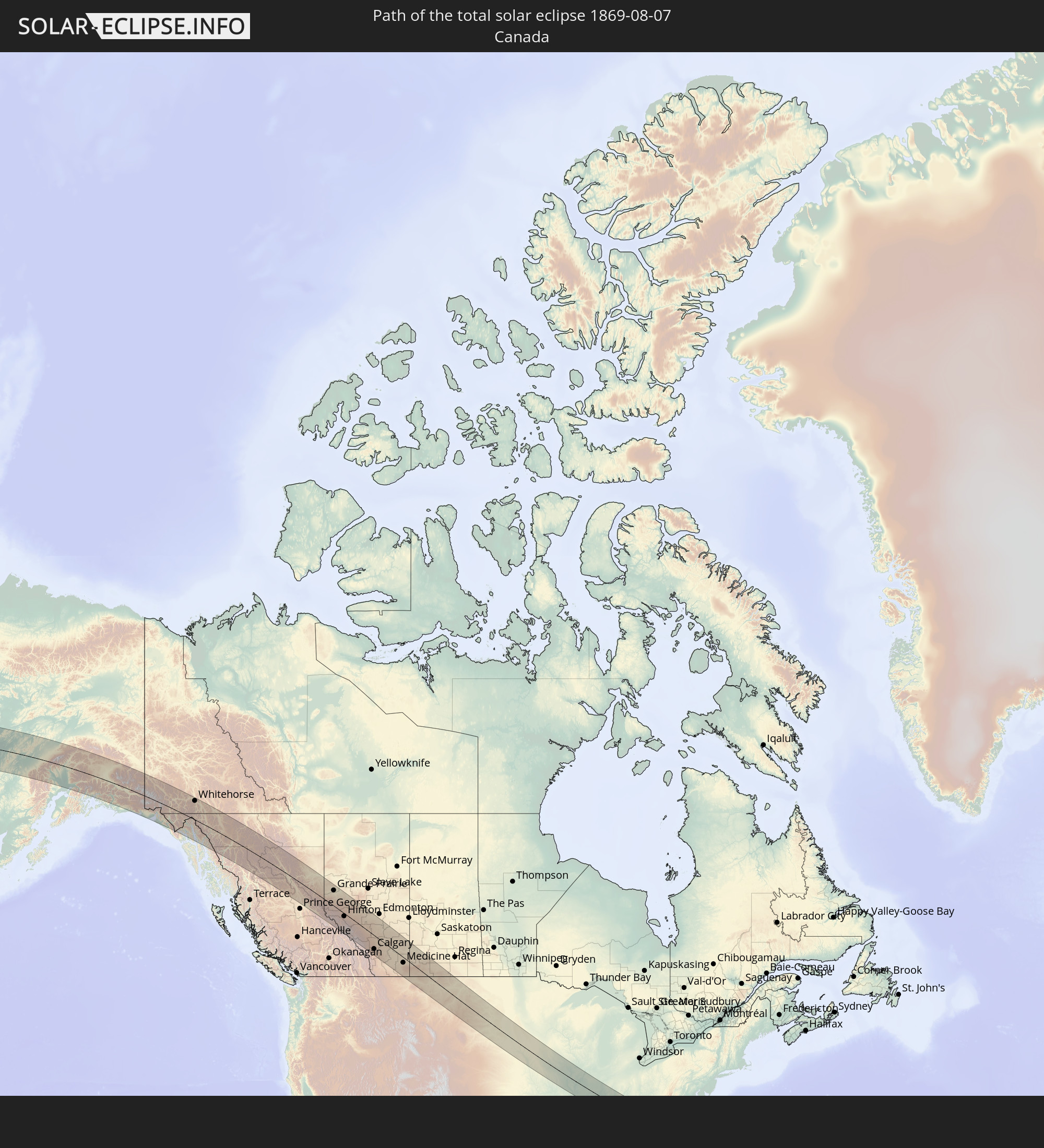 Canada
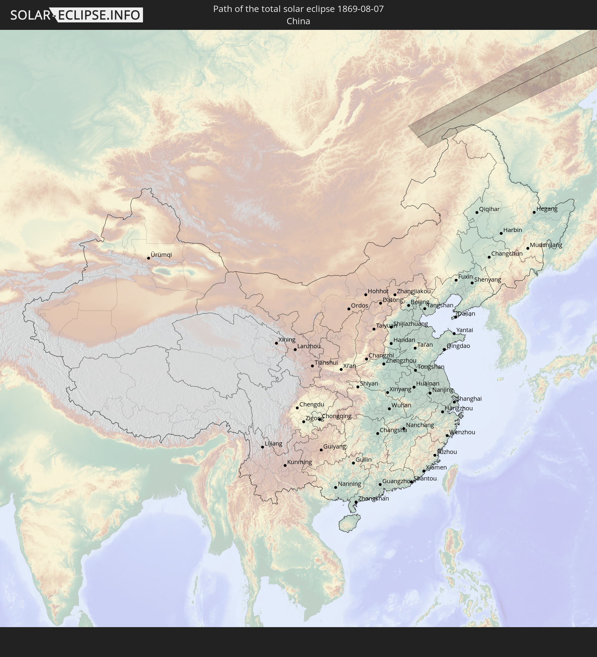 China
China
In den folgenden Ländern ist die Sonnenfinsternis partiell zu sehen


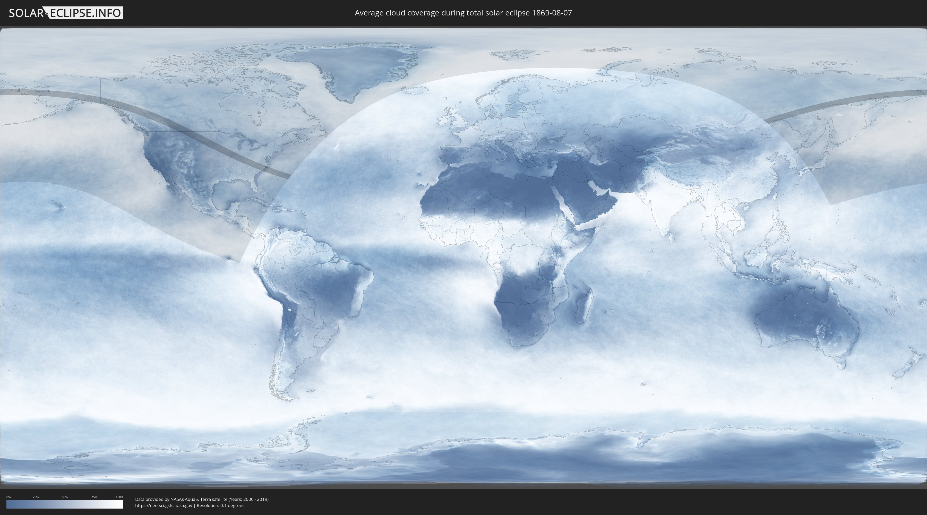
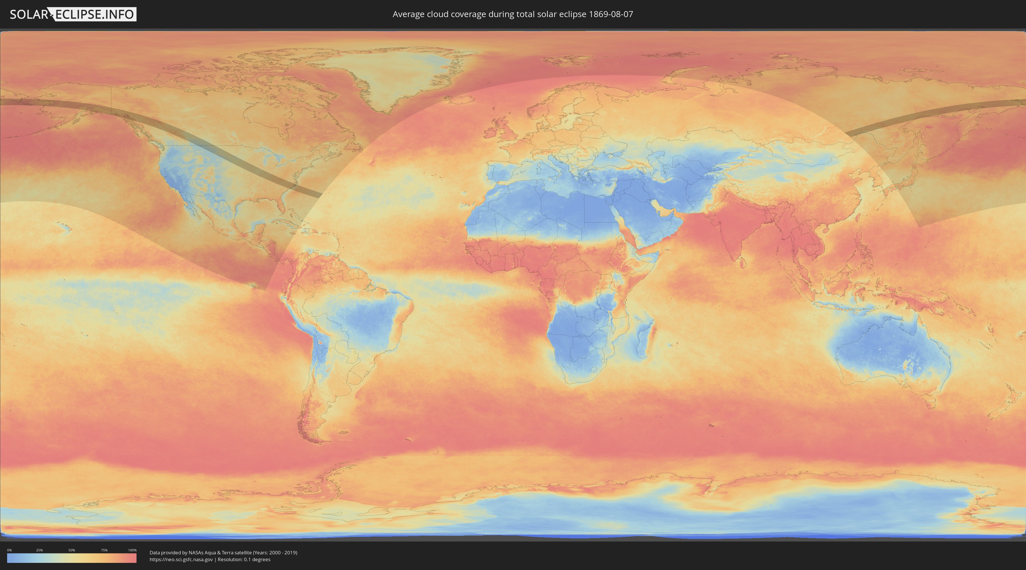
How will be the weather during the total solar eclipse on 08/07/1869?
Where is the best place to see the total solar eclipse of 08/07/1869?
The following maps show the average cloud coverage for the day of the total solar eclipse.
With the help of these maps, it is possible to find the place along the eclipse path, which has the best
chance of a cloudless sky.
Nevertheless, you should consider local circumstances and inform about the weather of your chosen
observation site.
The data is provided by NASAs satellites
AQUA and TERRA.
The cloud maps are averaged over a period of 19 years (2000 - 2019).
Detailed country maps
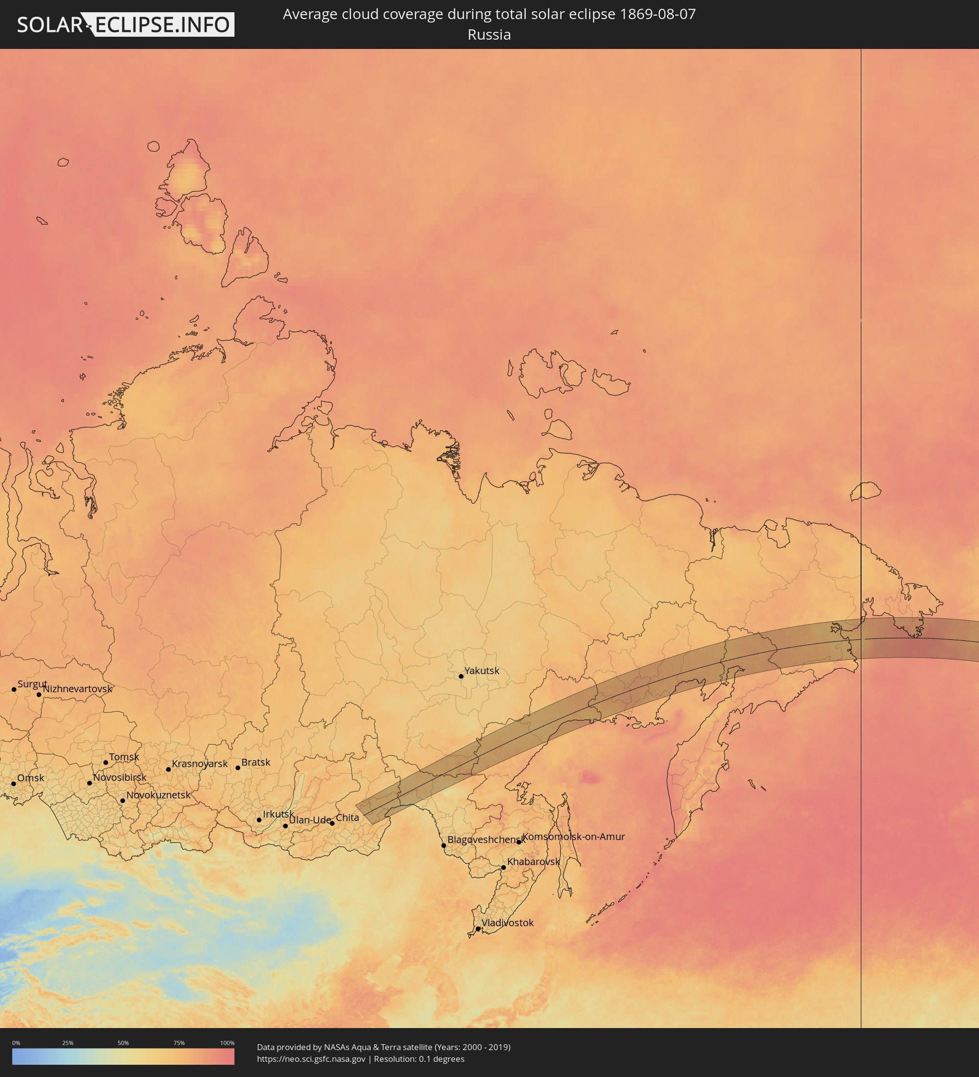 Russia
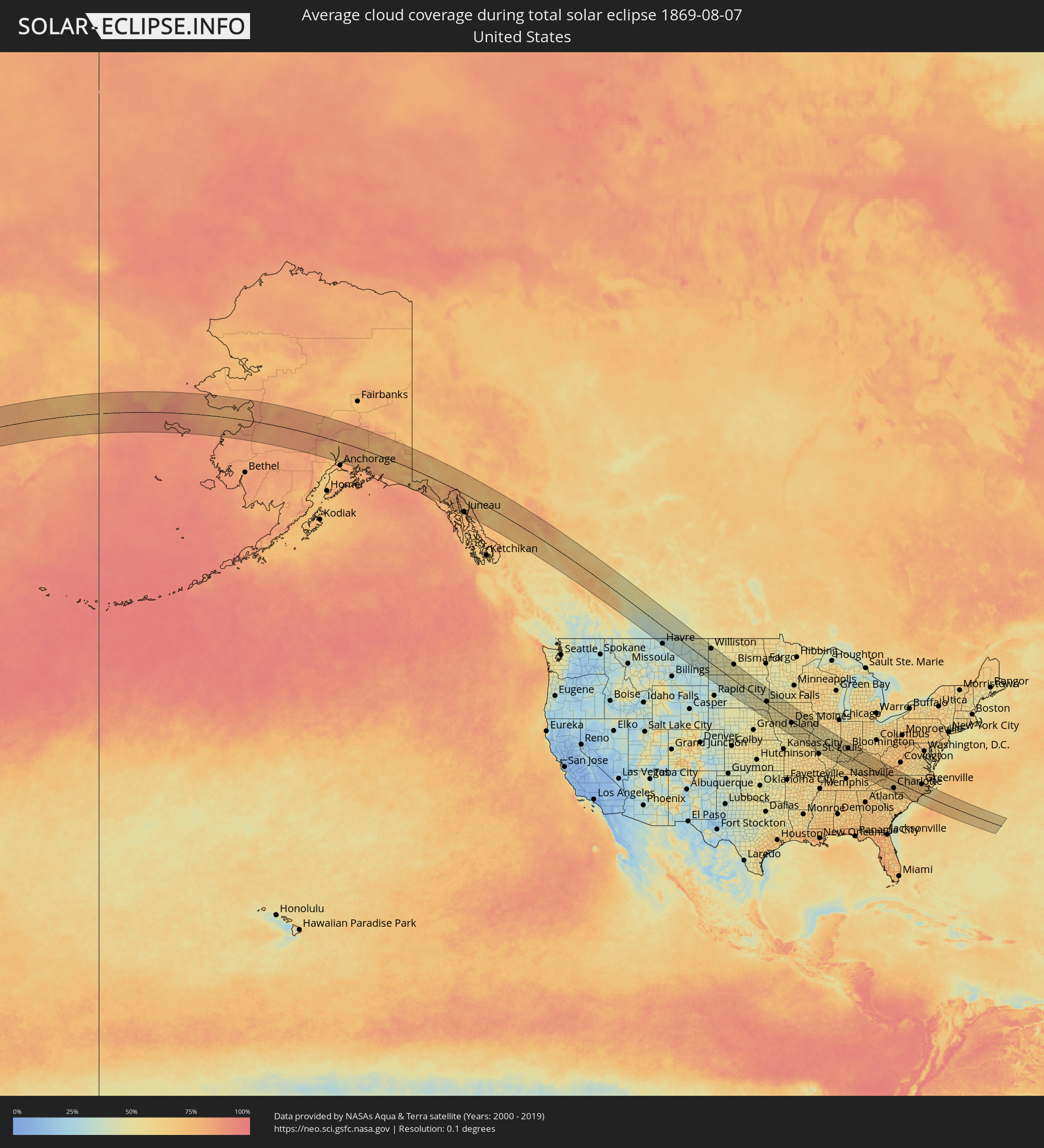 United States
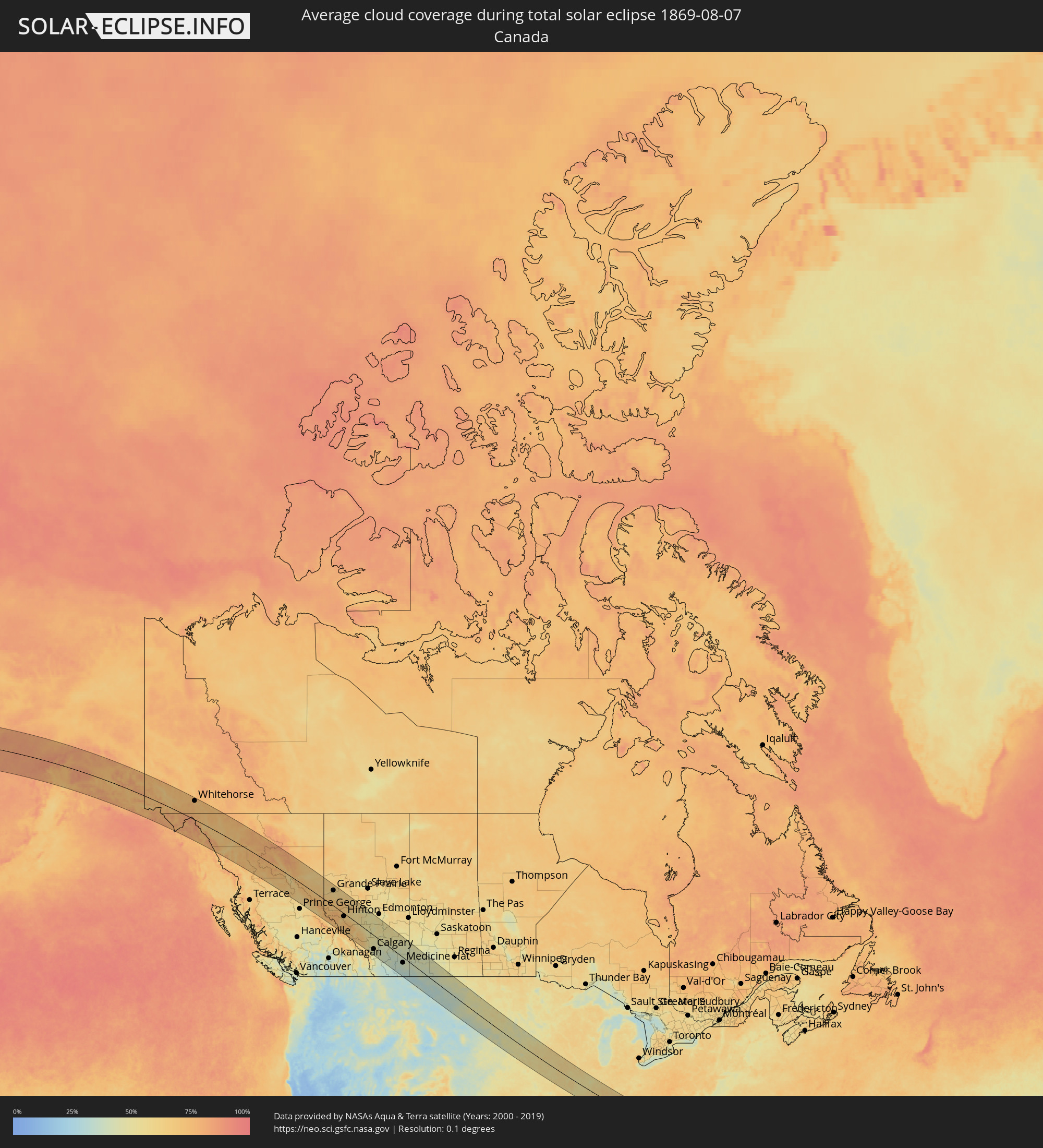 Canada
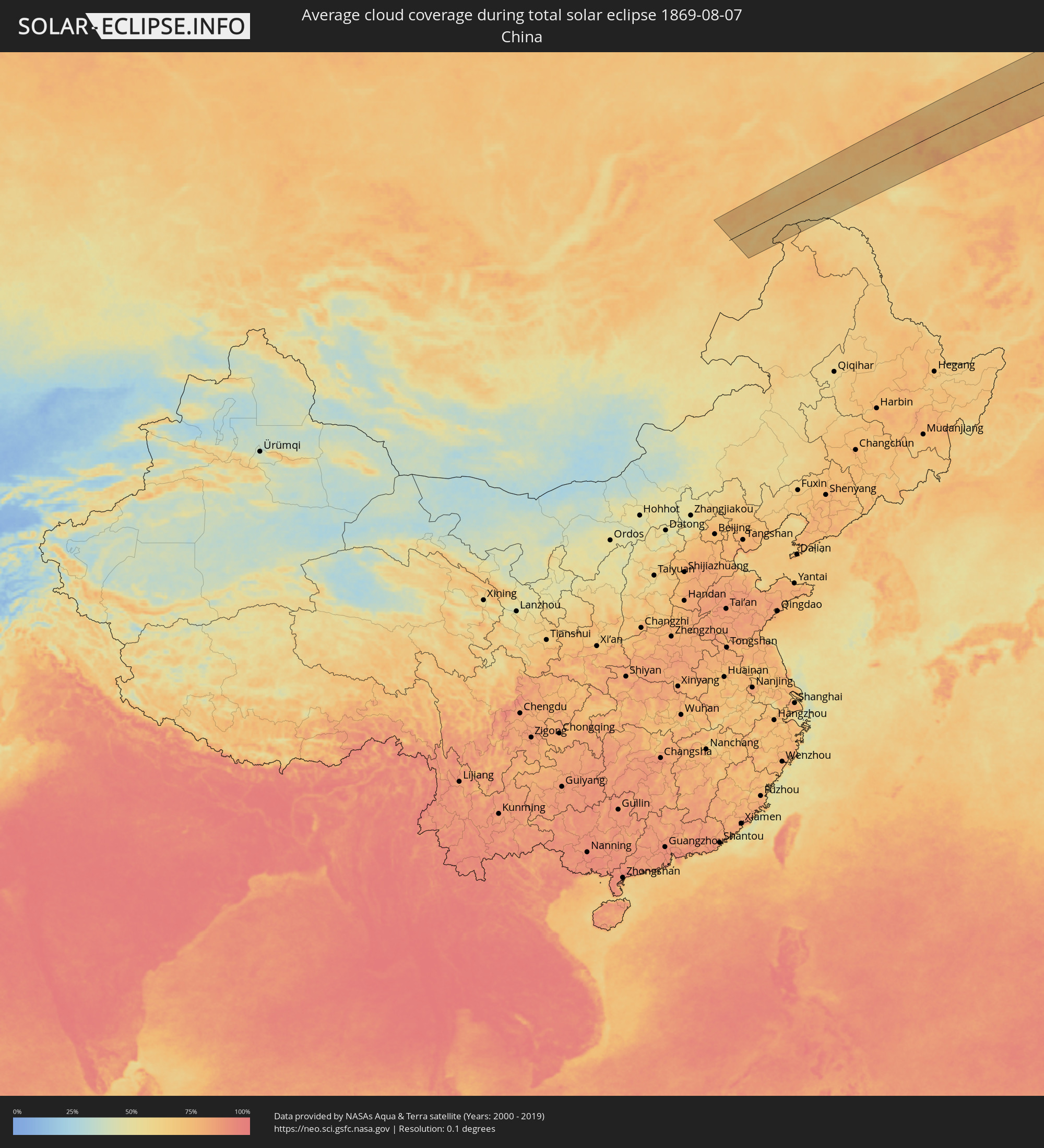 China
China
Cities inside the path of the eclipse
The following table shows all locations with a population of more than 5,000 inside the eclipse path. Cities which have more than 100,000 inhabitants are marked bold. A click at the locations opens a detailed map.
| City | Type | Eclipse duration | Local time of max. eclipse | Distance to central line | Ø Cloud coverage |
 Whitehorse, Yukon
|
total | - | 13:57:33 UTC-08:00 | 109 km | 73% |
 Juneau, Alaska
|
total | - | 12:00:27 UTC-10:00 | 113 km | 73% |
|
Fort St. John, British Columbia
|
total | - | 14:17:20 UTC-08:00 | 119 km | 62% |
|
Dawson Creek, British Columbia
|
total | - | 14:18:38 UTC-08:00 | 96 km | 63% |
|
Grande Prairie, Alberta
|
total | - | 14:47:02 UTC-07:33 | 96 km | 60% |
|
Hinton, Alberta
|
total | - | 14:50:57 UTC-07:33 | 19 km | 61% |
|
Edson, Alberta
|
total | - | 14:51:44 UTC-07:33 | 46 km | 57% |
|
Whitecourt, Alberta
|
total | - | 14:51:31 UTC-07:33 | 124 km | 57% |
|
Drayton Valley, Alberta
|
total | - | 14:53:39 UTC-07:33 | 68 km | 51% |
|
Rocky Mountain House, Alberta
|
total | - | 14:55:06 UTC-07:33 | 12 km | 49% |
|
Cochrane, Alberta
|
total | - | 14:57:28 UTC-07:33 | 94 km | 44% |
|
Olds, Alberta
|
total | - | 14:56:48 UTC-07:33 | 26 km | 49% |
|
Sylvan Lake, Alberta
|
total | - | 14:55:56 UTC-07:33 | 30 km | 50% |
|
Calgary, Alberta
|
total | - | 14:58:02 UTC-07:33 | 90 km | 46% |
|
Airdrie, Alberta
|
total | - | 14:57:40 UTC-07:33 | 65 km | 48% |
|
Okotoks, Alberta
|
total | - | 14:58:40 UTC-07:33 | 114 km | 43% |
|
High River, Alberta
|
total | - | 14:59:01 UTC-07:33 | 123 km | 46% |
|
Red Deer, Alberta
|
total | - | 14:56:16 UTC-07:33 | 32 km | 54% |
|
Lacombe, Alberta
|
total | - | 14:56:00 UTC-07:33 | 54 km | 50% |
|
Ponoka, Alberta
|
total | - | 14:55:47 UTC-07:33 | 79 km | 55% |
|
Leduc, Alberta
|
total | - | 14:54:50 UTC-07:33 | 131 km | 53% |
|
Strathmore, Alberta
|
total | - | 14:58:40 UTC-07:33 | 61 km | 42% |
|
Wetaskiwin, Alberta
|
total | - | 14:55:29 UTC-07:33 | 112 km | 55% |
|
Stettler, Alberta
|
total | - | 14:57:08 UTC-07:33 | 81 km | 51% |
|
Taber, Alberta
|
total | - | 15:01:54 UTC-07:33 | 121 km | 36% |
|
Brooks, Alberta
|
total | - | 15:00:46 UTC-07:33 | 39 km | 34% |
|
Medicine Hat, Alberta
|
total | - | 15:02:43 UTC-07:33 | 37 km | 37% |
|
Swift Current, Saskatchewan
|
total | - | 15:39:50 UTC-06:58 | 113 km | 42% |
|
Bismarck, North Dakota
|
total | - | 16:49:10 UTC-06:00 | 124 km | 48% |
|
Sioux Falls, South Dakota
|
total | - | 16:56:56 UTC-06:00 | 25 km | 50% |
|
Sioux City, Iowa
|
total | - | 16:58:52 UTC-06:00 | 64 km | 54% |
|
Ames, Iowa
|
total | - | 17:00:45 UTC-06:00 | 32 km | 56% |
|
Des Moines, Iowa
|
total | - | 17:01:29 UTC-06:00 | 18 km | 56% |
|
Marshalltown, Iowa
|
total | - | 17:00:58 UTC-06:00 | 60 km | 56% |
|
Waterloo, Iowa
|
total | - | 17:00:24 UTC-06:00 | 123 km | 60% |
|
Cedar Rapids, Iowa
|
total | - | 17:01:26 UTC-06:00 | 111 km | 60% |
|
Iowa City, Iowa
|
total | - | 17:02:03 UTC-06:00 | 83 km | 63% |
|
Quincy, Illinois
|
total | - | 17:04:56 UTC-06:00 | 73 km | 54% |
|
Davenport, Iowa
|
total | - | 17:02:33 UTC-06:00 | 115 km | 59% |
|
Galesburg, Illinois
|
total | - | 17:03:33 UTC-06:00 | 72 km | 56% |
|
Upper Alton, Illinois
|
total | - | 17:06:55 UTC-06:00 | 113 km | 53% |
|
Springfield, Illinois
|
total | - | 17:05:36 UTC-06:00 | 6 km | 53% |
|
Peoria, Illinois
|
total | - | 17:04:10 UTC-06:00 | 81 km | 56% |
|
Bloomington, Illinois
|
total | - | 17:04:38 UTC-06:00 | 88 km | 54% |
|
Decatur, Illinois
|
total | - | 17:05:41 UTC-06:00 | 31 km | 54% |
|
Champaign, Illinois
|
total | - | 17:05:23 UTC-06:00 | 89 km | 58% |
|
Danville, Illinois
|
total | - | 17:05:29 UTC-06:00 | 116 km | 58% |
|
Henderson, Kentucky
|
total | - | 17:09:07 UTC-06:00 | 103 km | 58% |
|
Evansville, Indiana
|
total | - | 17:08:54 UTC-06:00 | 88 km | 57% |
|
Terre Haute, Indiana
|
total | - | 18:06:35 UTC-05:00 | 61 km | 63% |
|
Owensboro, Kentucky
|
total | - | 17:09:17 UTC-06:00 | 89 km | 61% |
|
Bloomington, Indiana
|
total | - | 18:07:12 UTC-05:00 | 71 km | 63% |
|
Columbus, Indiana
|
total | - | 18:07:13 UTC-05:00 | 101 km | 60% |
|
Elizabethtown, Kentucky
|
total | - | 18:09:34 UTC-05:00 | 41 km | 65% |
|
Louisville, Kentucky
|
total | - | 18:08:43 UTC-05:00 | 17 km | 66% |
|
Jeffersontown, Kentucky
|
total | - | 18:08:50 UTC-05:00 | 20 km | 70% |
|
Nicholasville, Kentucky
|
total | - | 18:09:25 UTC-05:00 | 41 km | 68% |
|
Georgetown, Kentucky
|
total | - | 18:08:55 UTC-05:00 | 65 km | 63% |
|
Lexington-Fayette, Kentucky
|
total | - | 18:09:10 UTC-05:00 | 59 km | 69% |
|
Richmond, Kentucky
|
total | - | 18:09:38 UTC-05:00 | 31 km | 70% |
|
Morristown, Tennessee
|
total | - | 18:12:00 UTC-05:00 | 78 km | 68% |
|
Kingsport, Tennessee
|
total | - | 18:11:32 UTC-05:00 | 14 km | 67% |
|
Asheville, North Carolina
|
total | - | 18:12:55 UTC-05:00 | 107 km | 62% |
|
Johnson City, Tennessee
|
total | - | 18:11:53 UTC-05:00 | 28 km | 69% |
|
Bristol, Tennessee
|
total | - | 18:11:28 UTC-05:00 | 6 km | 68% |
|
Hickory, North Carolina
|
total | - | 18:12:44 UTC-05:00 | 44 km | 65% |
|
Gastonia, North Carolina
|
total | - | 18:13:24 UTC-05:00 | 85 km | 67% |
|
Rock Hill, South Carolina
|
total | - | 18:13:53 UTC-05:00 | 112 km | 64% |
|
Charlotte, North Carolina
|
total | - | 18:13:27 UTC-05:00 | 75 km | 75% |
|
Huntersville, North Carolina
|
total | - | 18:13:11 UTC-05:00 | 57 km | 71% |
|
Mooresville, North Carolina
|
total | - | 18:12:56 UTC-05:00 | 40 km | 63% |
|
Indian Trail, North Carolina
|
total | - | 18:13:39 UTC-05:00 | 86 km | 73% |
|
Concord, North Carolina
|
total | - | 18:13:10 UTC-05:00 | 48 km | 69% |
|
Salisbury, North Carolina
|
total | - | 18:12:48 UTC-05:00 | 19 km | 67% |
|
Winston-Salem, North Carolina
|
total | - | 18:12:10 UTC-05:00 | 37 km | 71% |
|
High Point, North Carolina
|
total | - | 18:12:22 UTC-05:00 | 32 km | 70% |
|
Greensboro, North Carolina
|
total | - | 18:12:11 UTC-05:00 | 52 km | 71% |
|
Burlington, North Carolina
|
total | - | 18:12:08 UTC-05:00 | 68 km | 69% |
|
Danville, Virginia
|
total | - | 18:11:26 UTC-05:00 | 119 km | 66% |
|
Sanford, North Carolina
|
total | - | 18:13:00 UTC-05:00 | 29 km | 69% |
|
Chapel Hill, North Carolina
|
total | - | 18:12:22 UTC-05:00 | 67 km | 65% |
|
Fort Bragg, North Carolina
|
total | - | 18:13:28 UTC-05:00 | 11 km | 74% |
|
Durham, North Carolina
|
total | - | 18:12:15 UTC-05:00 | 83 km | 74% |
|
Fayetteville, North Carolina
|
total | - | 18:13:35 UTC-05:00 | 24 km | 74% |
|
Apex, North Carolina
|
total | - | 18:12:37 UTC-05:00 | 57 km | 66% |
|
Raleigh, North Carolina
|
total | - | 18:12:33 UTC-05:00 | 68 km | 72% |
|
Wake Forest, North Carolina
|
total | - | 18:12:14 UTC-05:00 | 94 km | 64% |
|
Goldsboro, North Carolina
|
total | - | 18:13:02 UTC-05:00 | 59 km | 69% |
|
Wilmington, North Carolina
|
total | - | 18:14:39 UTC-05:00 | 63 km | 68% |
|
Wilson, North Carolina
|
total | - | 18:12:33 UTC-05:00 | 91 km | 70% |
|
Rocky Mount, North Carolina
|
total | - | 18:12:14 UTC-05:00 | 117 km | 67% |
|
Jacksonville, North Carolina
|
total | - | 18:13:51 UTC-05:00 | 12 km | 69% |
|
Greenville, North Carolina
|
total | - | 18:12:39 UTC-05:00 | 102 km | 71% |
|
New Bern, North Carolina
|
total | - | 18:13:19 UTC-05:00 | 65 km | 64% |
 Mogocha, Transbaikal Territory
|
total | - | 05:25:38 UTC+08:38 | 27 km | 71% |
|
Yerofey Pavlovich, Amur
|
total | - | 05:25:16 UTC+08:38 | 21 km | 67% |
|
Skovorodino, Amur
|
total | - | 05:24:47 UTC+08:38 | 75 km | 63% |
|
Tynda, Amur
|
total | - | 05:26:03 UTC+08:38 | 21 km | 68% |
|
Okhotsk, Khabarovsk Krai
|
total | - | 05:39:26 UTC+08:47 | 37 km | 75% |
|
Anadyr, Chukotskiy Avtonomnyy Okrug
|
total | - | 09:03:22 UTC+11:49 | 71 km | 74% |