Annular solar eclipse of 02/01/2223
| Day of week: | Saturday |
| Maximum duration of eclipse: | 09m26s |
| Maximum width of eclipse path: | 279 km |
| Saros cycle: | 144 |
| Coverage: | 92.6% |
| Magnitude: | 0.9263 |
| Gamma: | -0.118 |
Wo kann man die Sonnenfinsternis vom 02/01/2223 sehen?
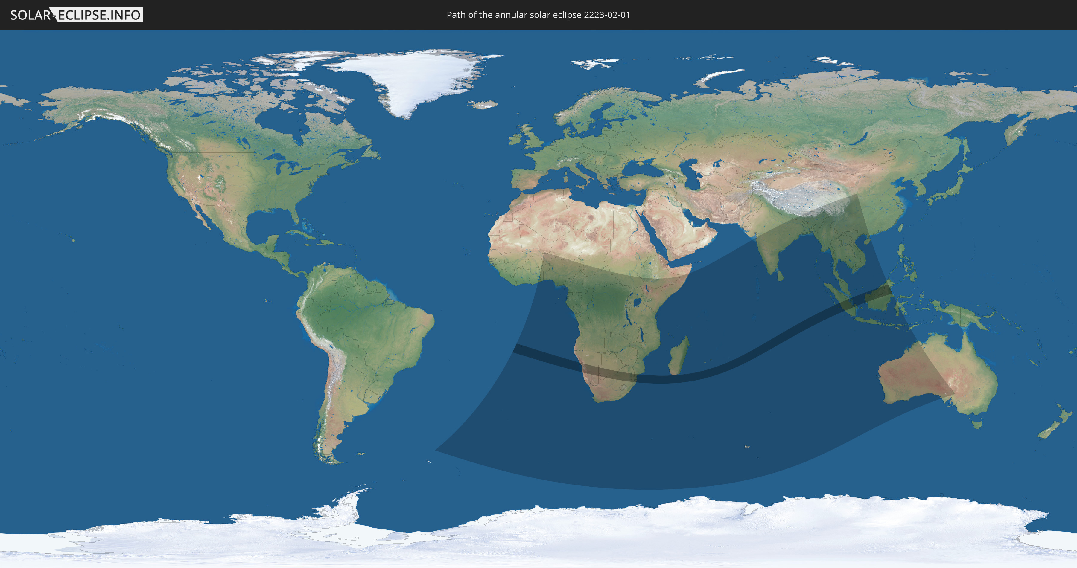
Die Sonnenfinsternis am 02/01/2223 kann man in 63 Ländern als partielle Sonnenfinsternis beobachten.
Der Finsternispfad verläuft durch 10 Länder. Nur in diesen Ländern ist sie als annular Sonnenfinsternis zu sehen.
In den folgenden Ländern ist die Sonnenfinsternis annular zu sehen
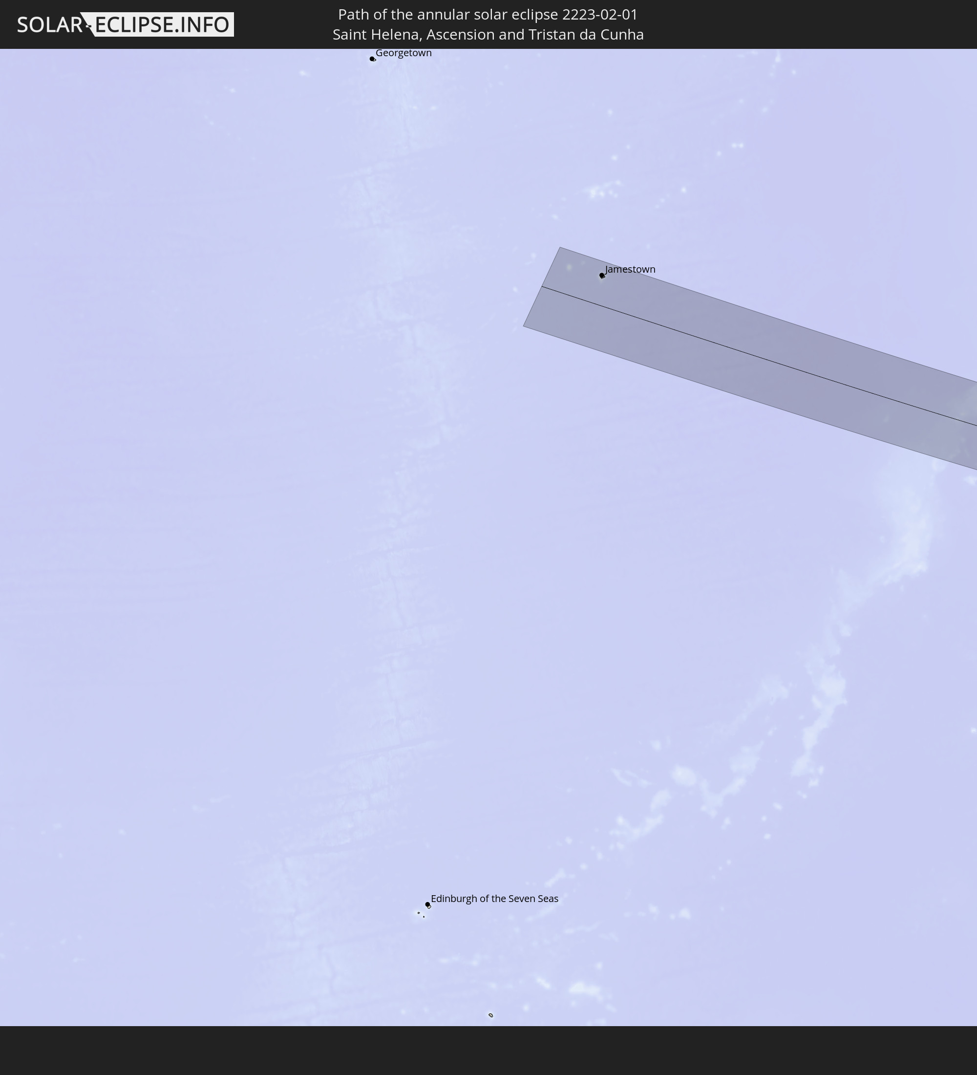 Saint Helena, Ascension and Tristan da Cunha
 Namibia
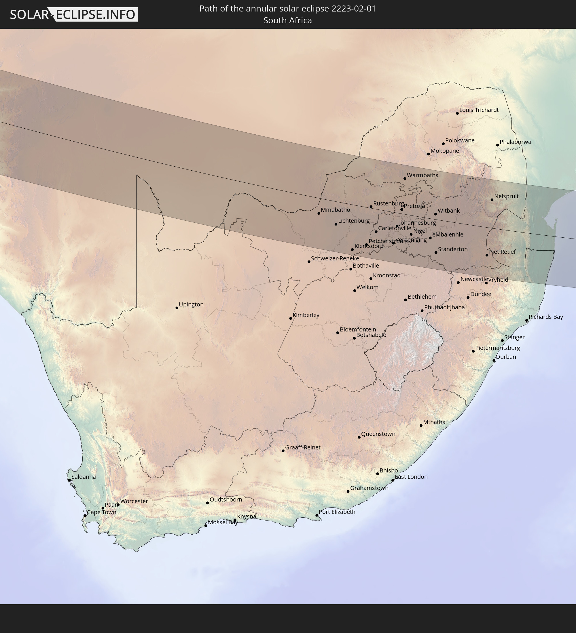 South Africa
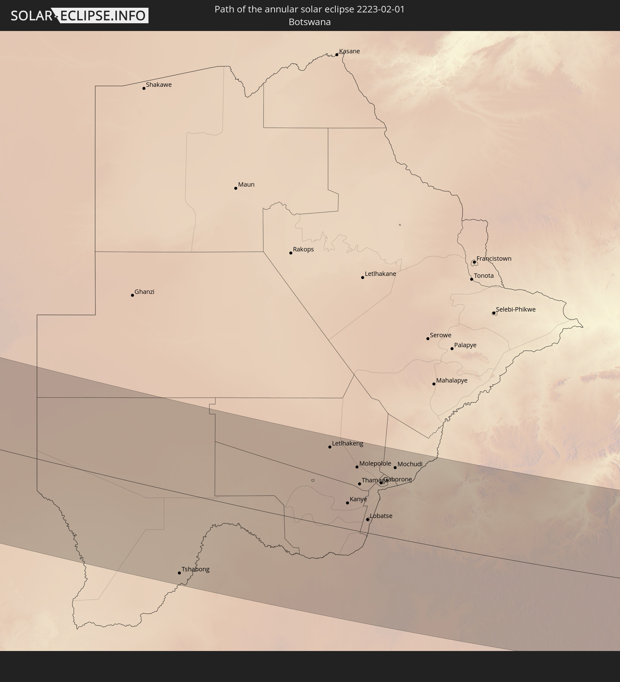 Botswana
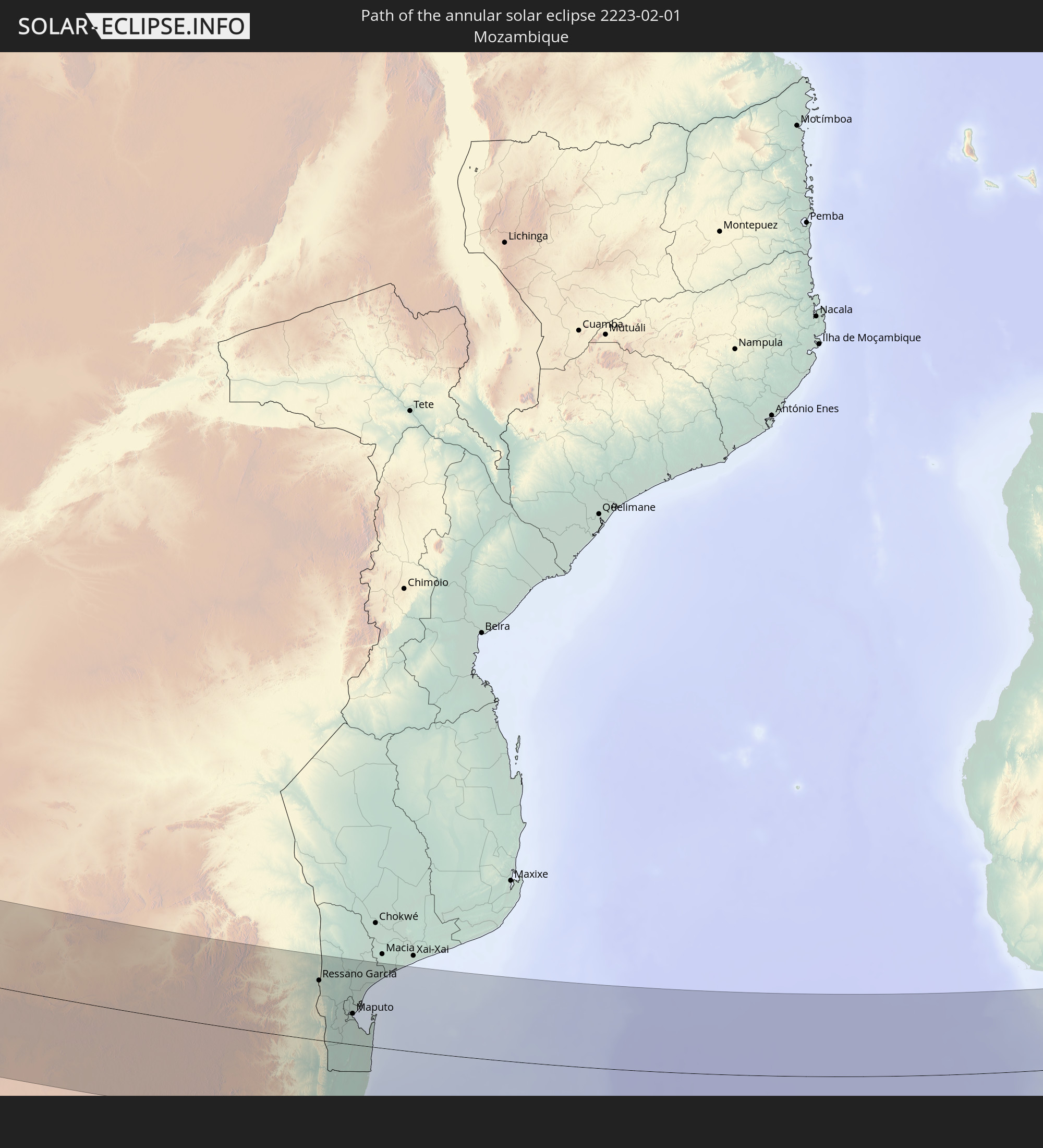 Mozambique
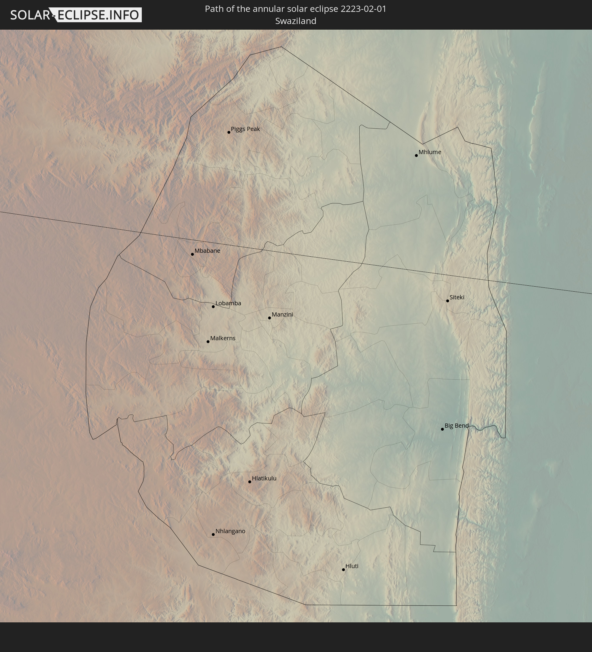 Swaziland
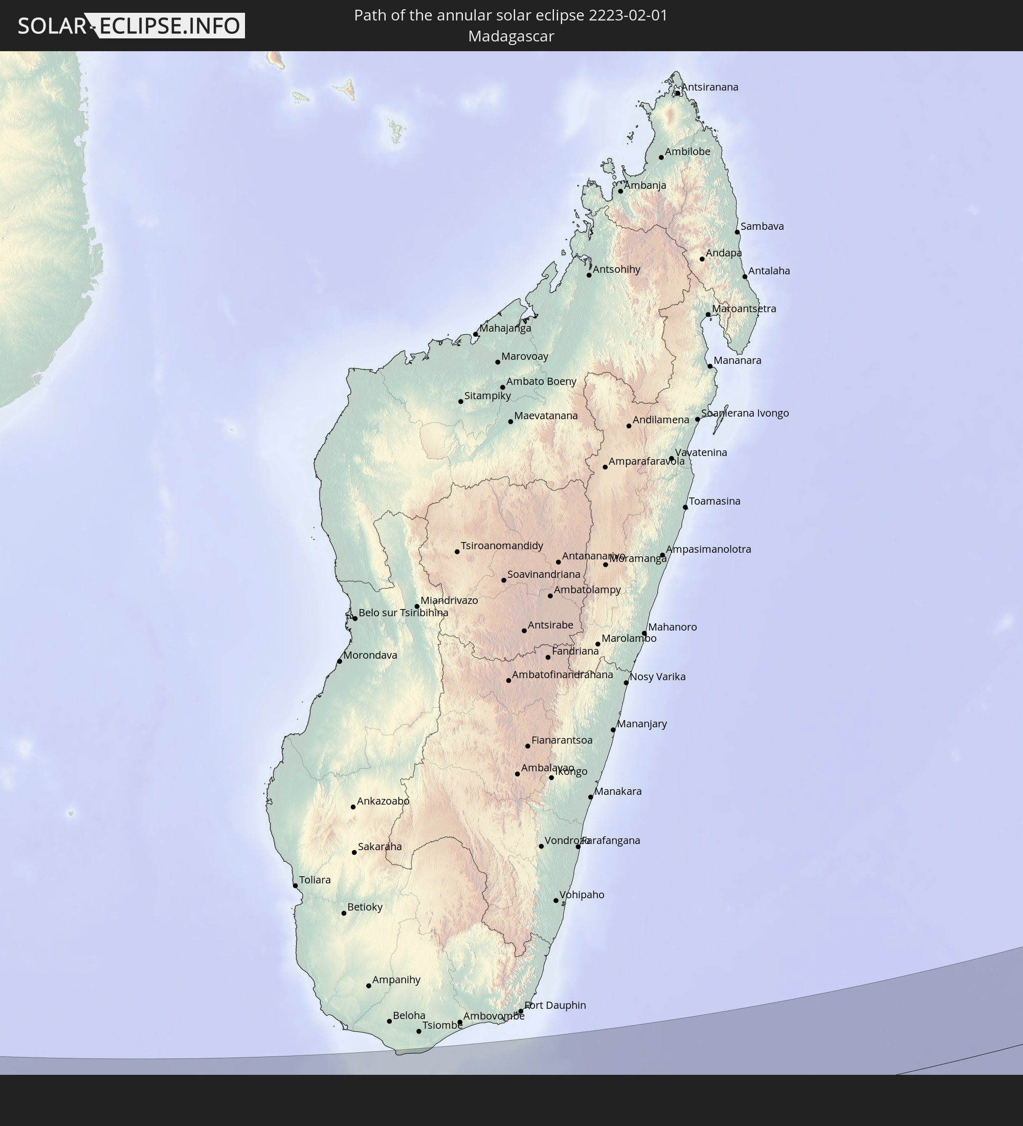 Madagascar
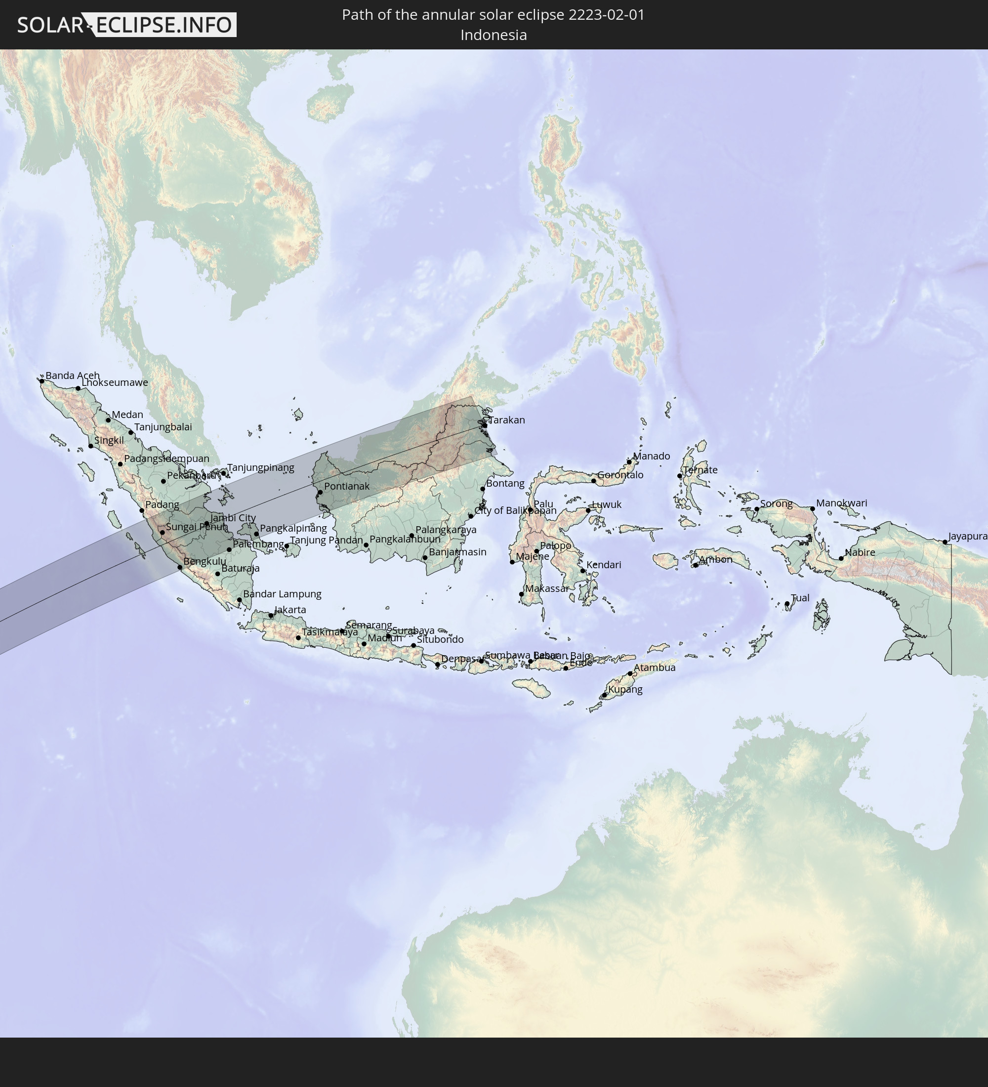 Indonesia
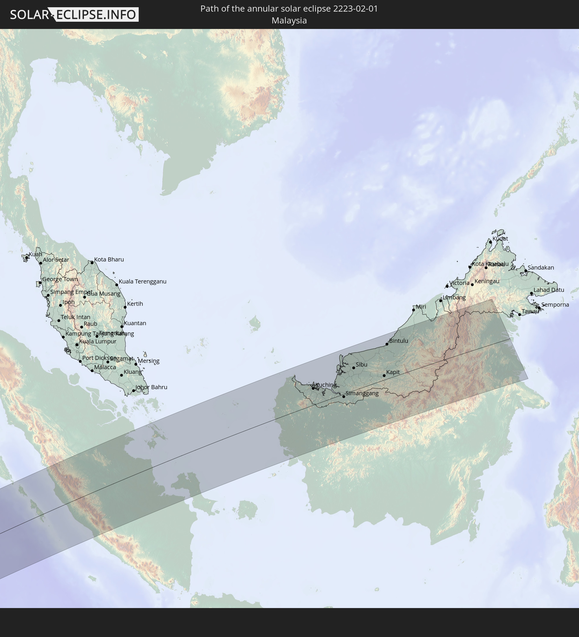 Malaysia
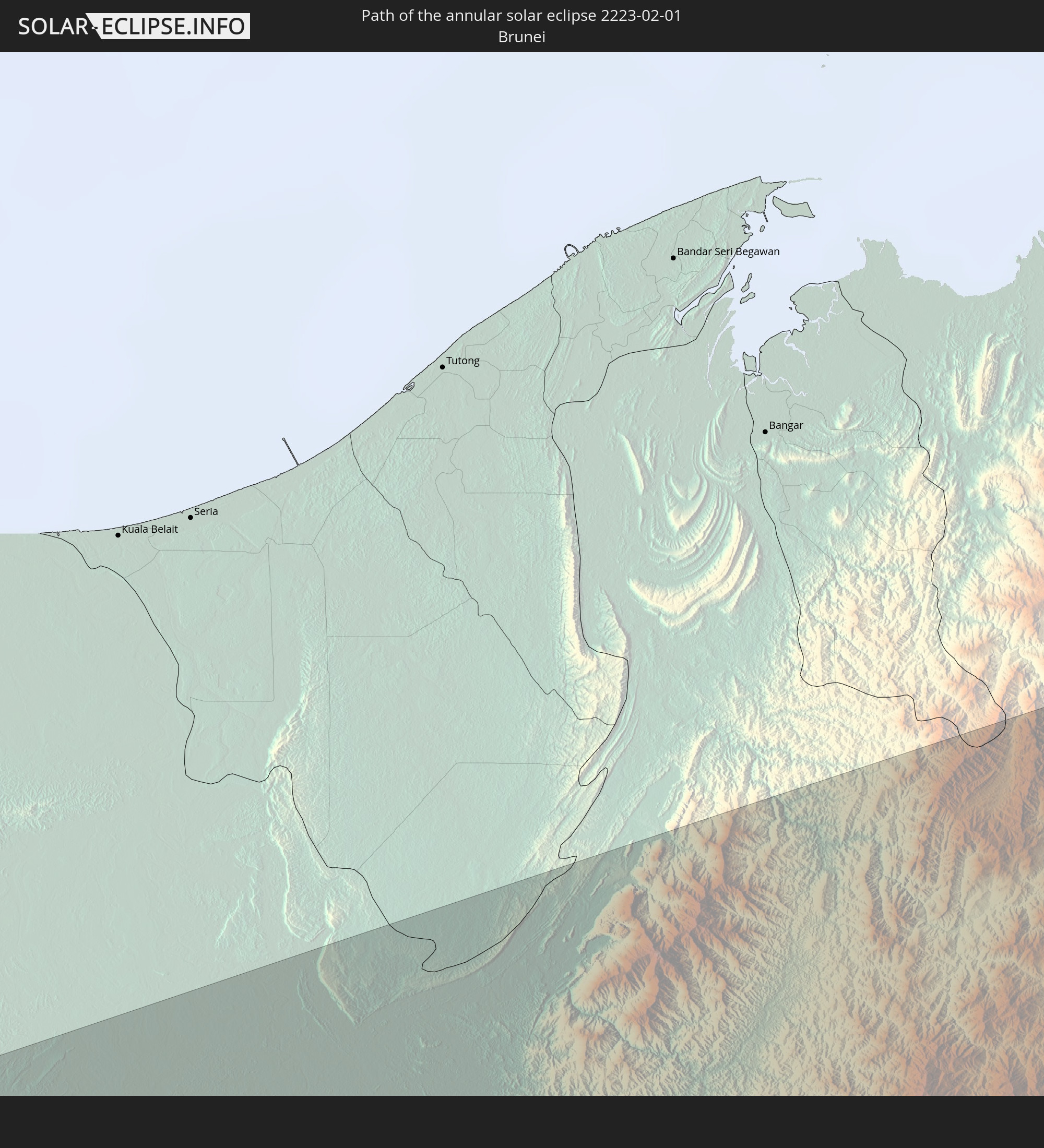 Brunei
In den folgenden Ländern ist die Sonnenfinsternis partiell zu sehen
 Saint Helena, Ascension and Tristan da Cunha
 Mali
Mali
 Burkina Faso
 Ghana
Ghana
 Togo
Togo
 Niger
Niger
 Benin
Benin
 Nigeria
 Bouvet Island
 Equatorial Guinea
 São Tomé and Príncipe
 Cameroon
 Gabon
Gabon
 Republic of the Congo
 Angola
 Namibia
 Democratic Republic of the Congo
 Chad
Chad
 Central African Republic
 South Africa
 Botswana
 Sudan
Sudan
 Zambia
 Zimbabwe
 Lesotho
 Rwanda
 Burundi
 Tanzania
 Uganda
 Mozambique
 Swaziland
 Malawi
 Ethiopia
 Kenya
Kenya
 French Southern and Antarctic Lands
 Somalia
 Madagascar
 Comoros
 Mayotte
 Seychelles
 Réunion
 Mauritius
 India
India
 British Indian Ocean Territory
 Heard Island and McDonald Islands
 Maldives
 China
China
 Sri Lanka
 Nepal
Nepal
 Bangladesh
 Bhutan
 Myanmar
 Indonesia
 Cocos Islands
 Thailand
 Malaysia
 Laos
Laos
 Vietnam
 Cambodia
 Singapore
 Christmas Island
 Australia
 Brunei
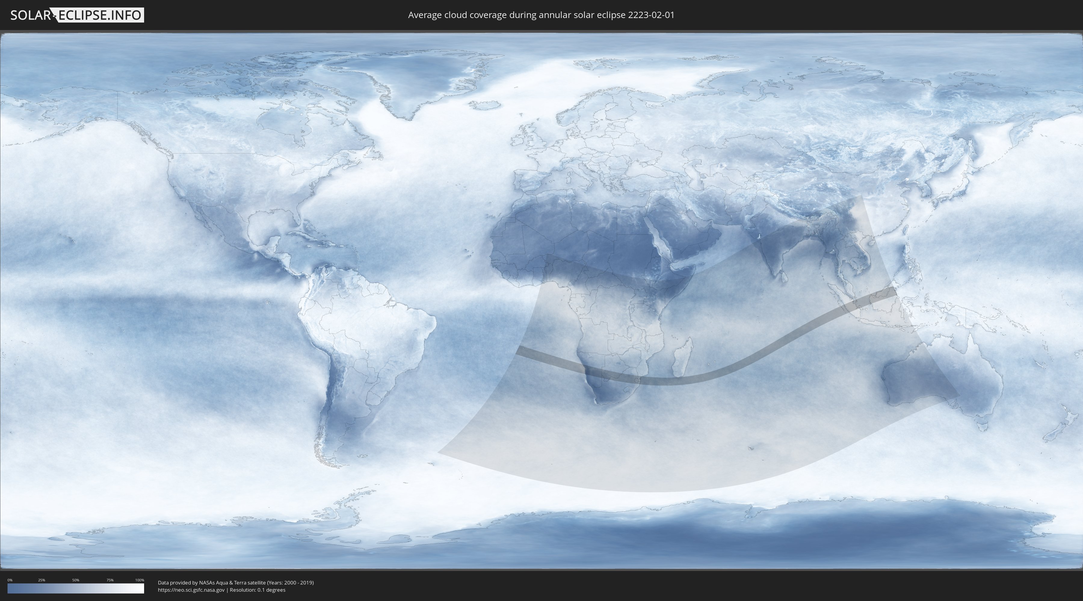
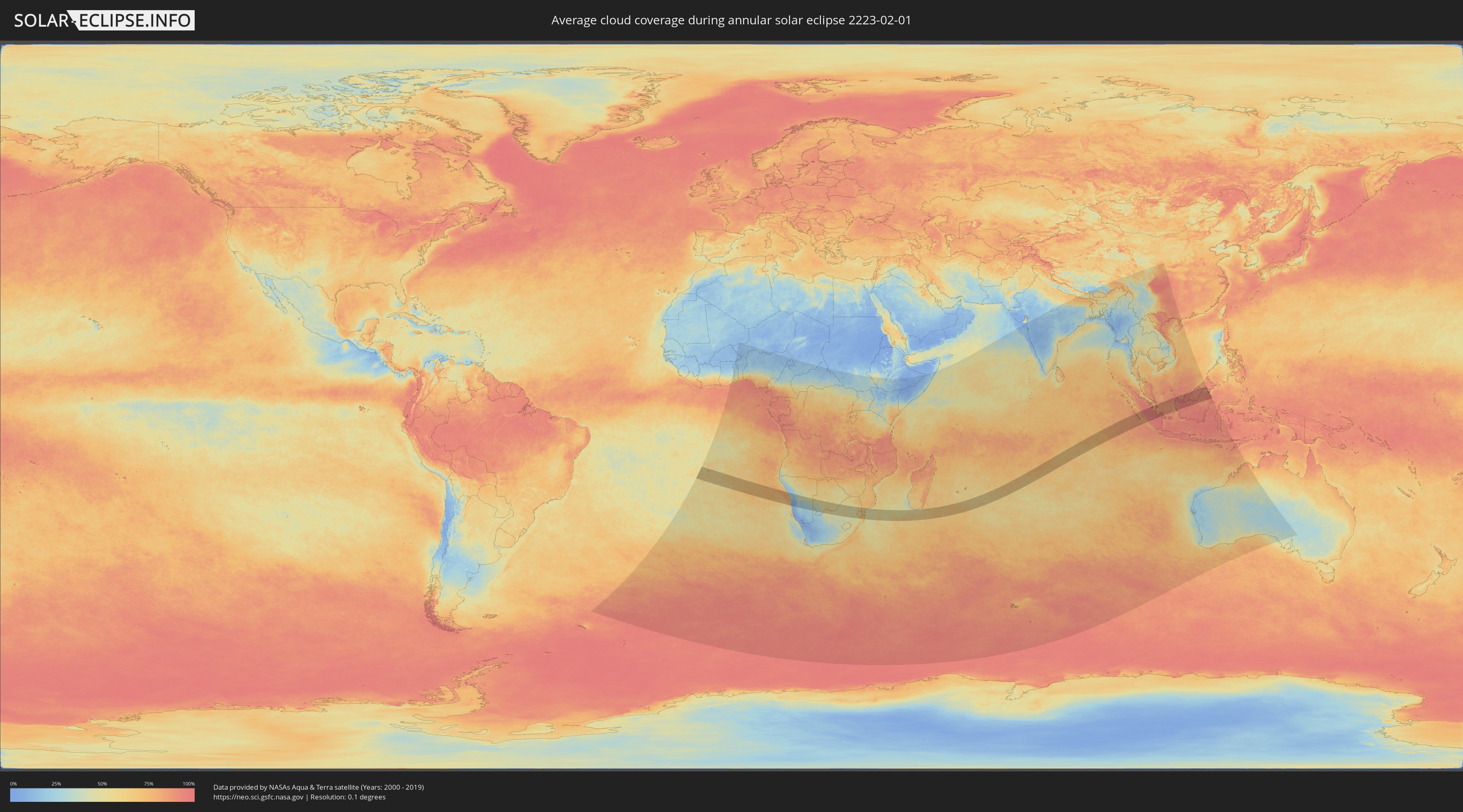
How will be the weather during the annular solar eclipse on 02/01/2223?
Where is the best place to see the annular solar eclipse of 02/01/2223?
The following maps show the average cloud coverage for the day of the annular solar eclipse.
With the help of these maps, it is possible to find the place along the eclipse path, which has the best
chance of a cloudless sky.
Nevertheless, you should consider local circumstances and inform about the weather of your chosen
observation site.
The data is provided by NASAs satellites
AQUA and TERRA.
The cloud maps are averaged over a period of 19 years (2000 - 2019).
Detailed country maps
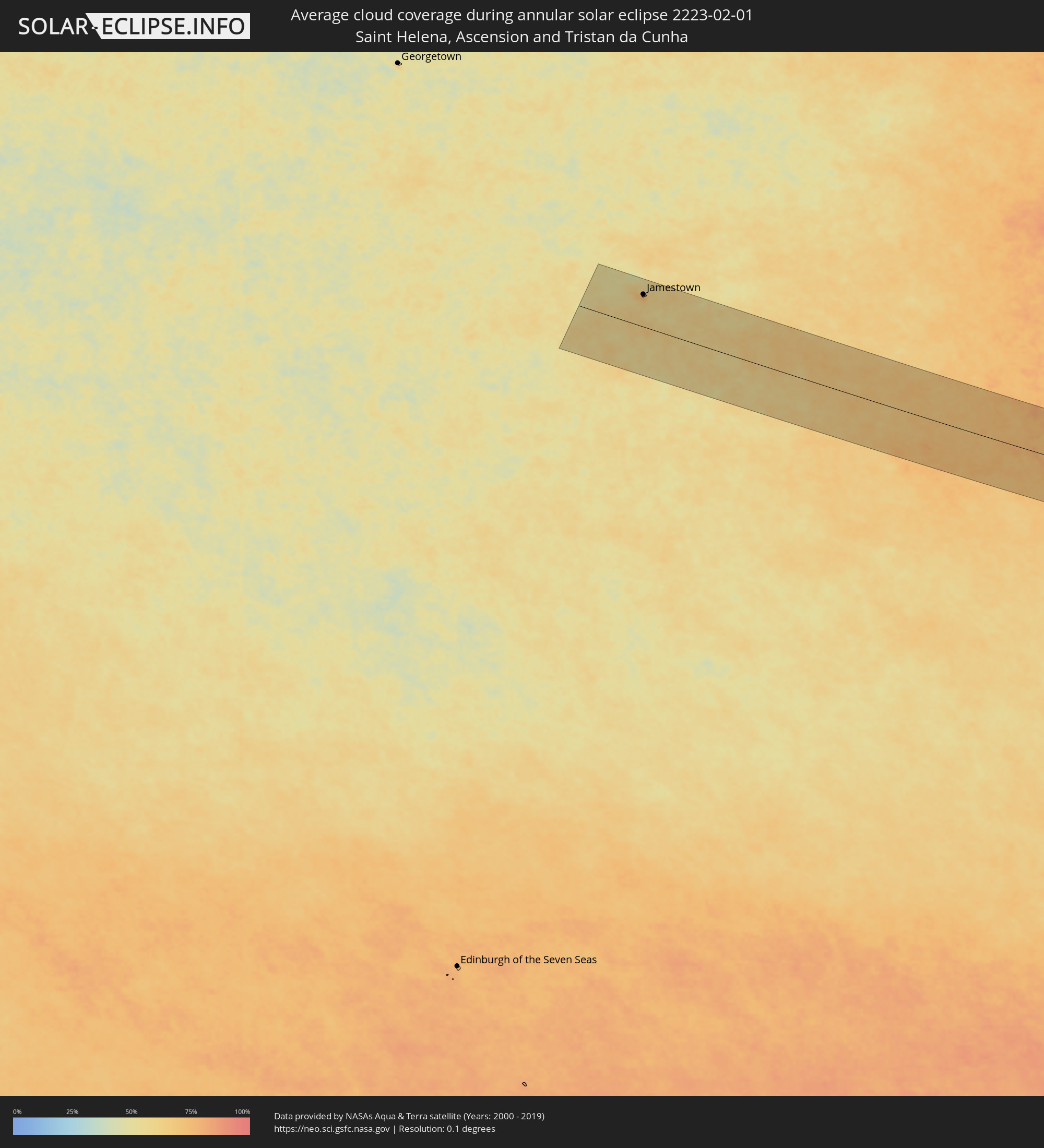 Saint Helena, Ascension and Tristan da Cunha
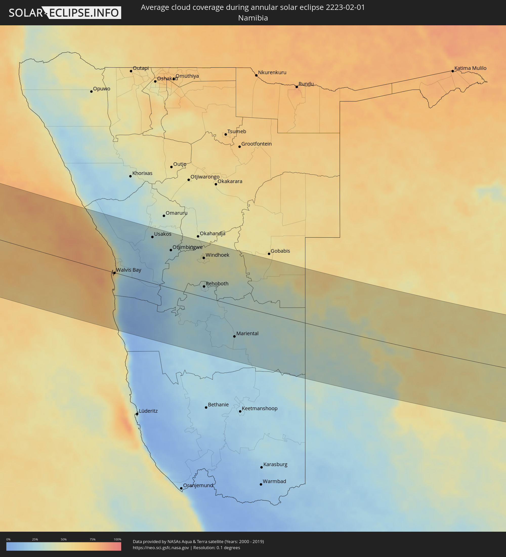 Namibia
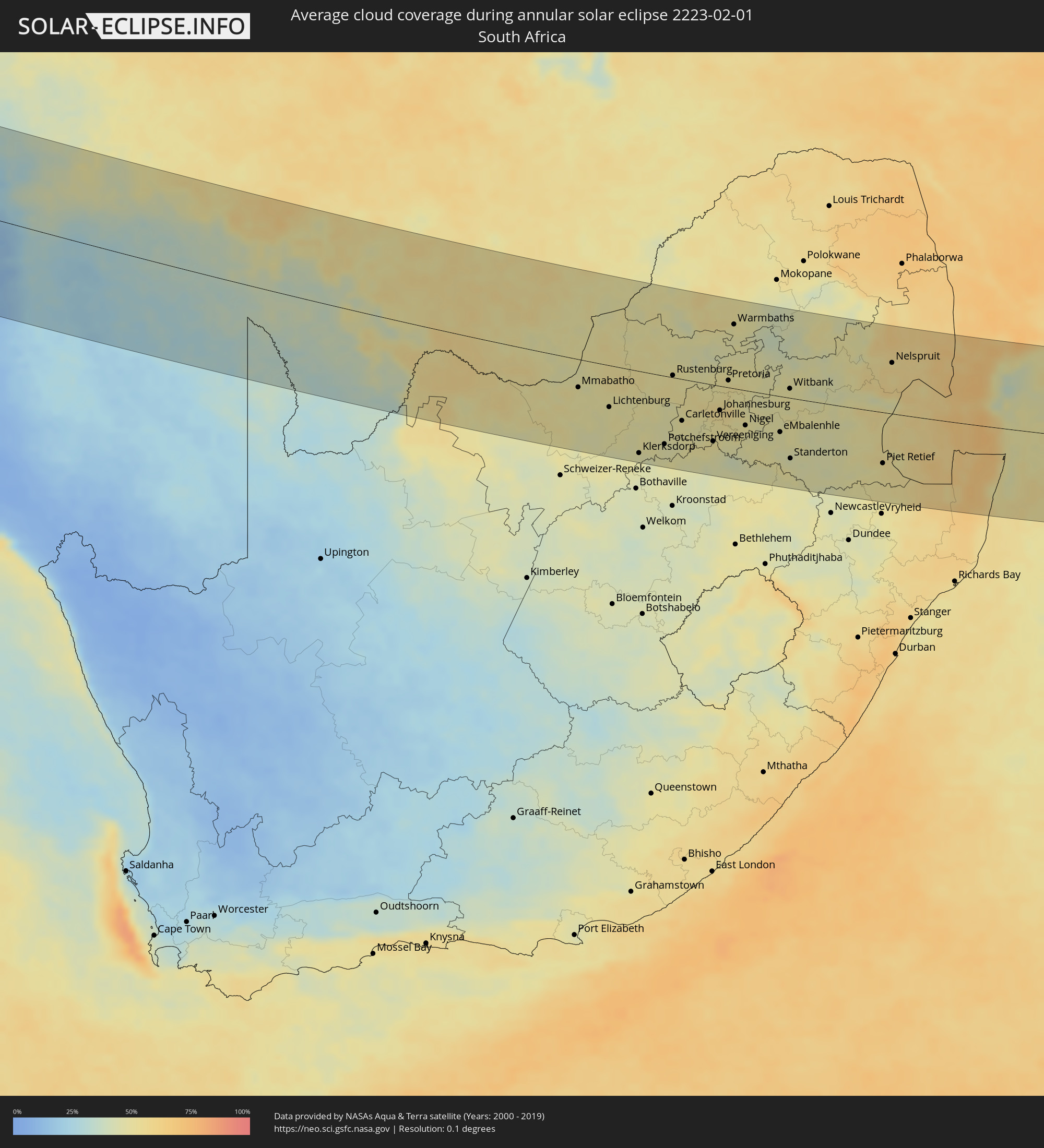 South Africa
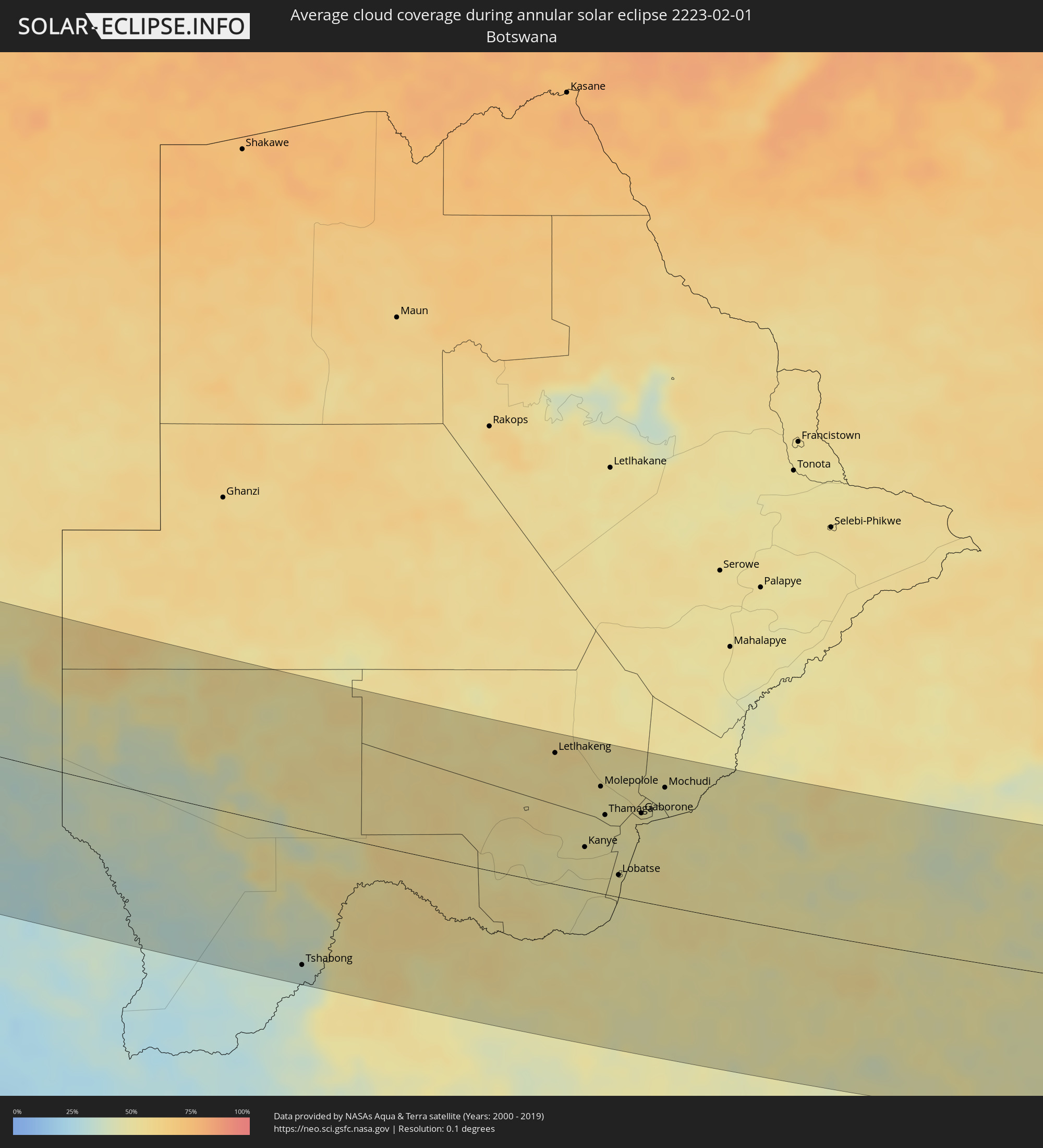 Botswana
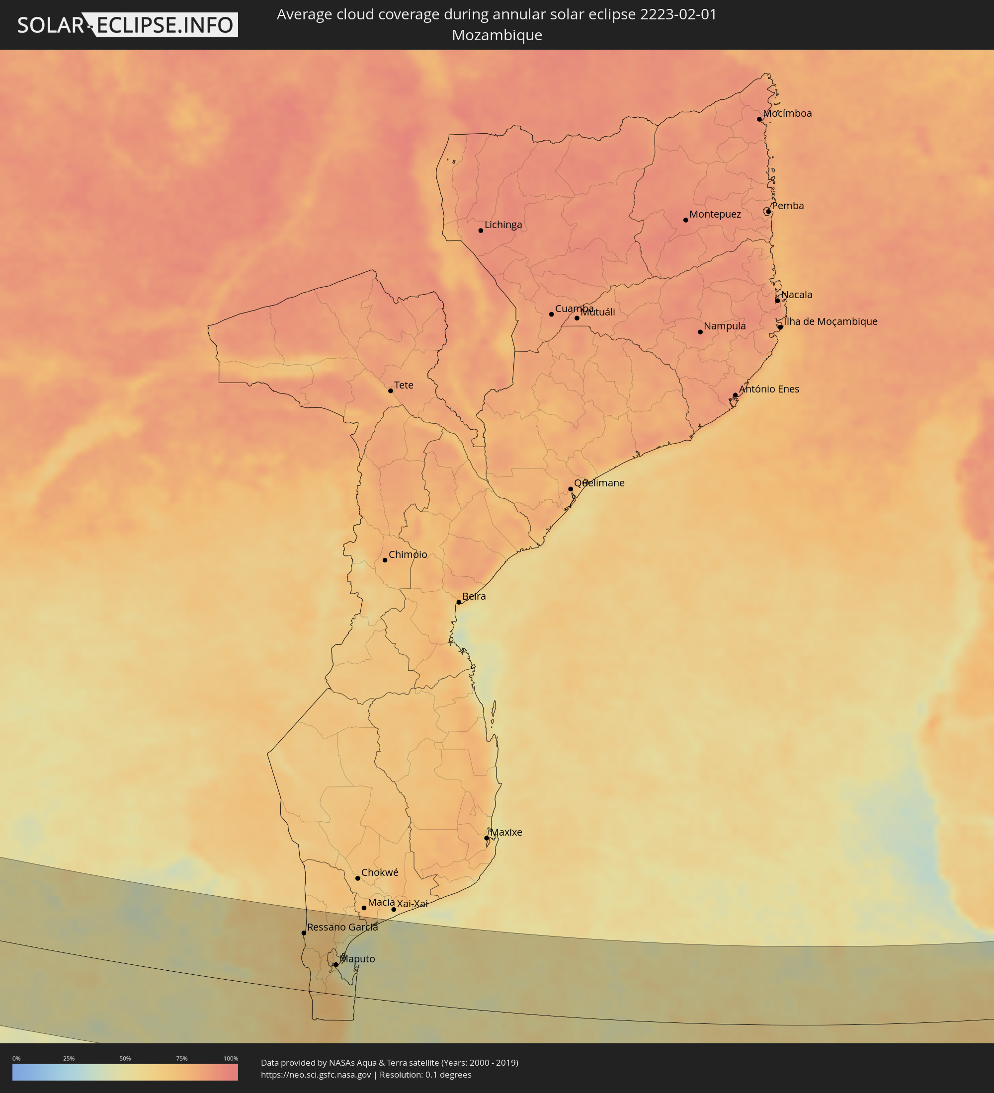 Mozambique
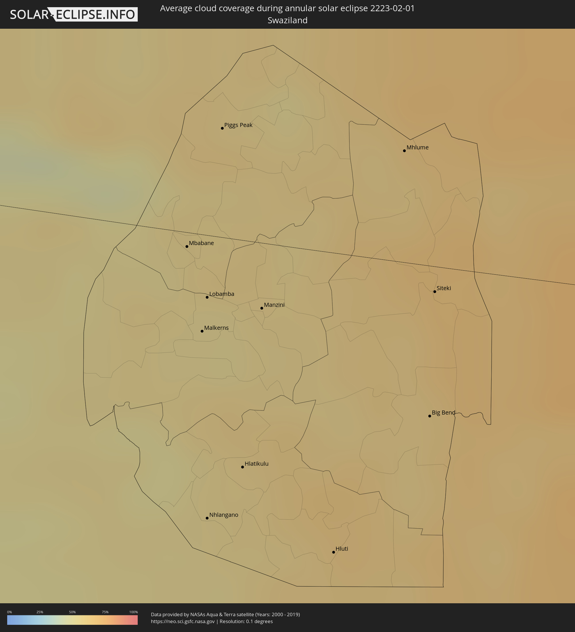 Swaziland
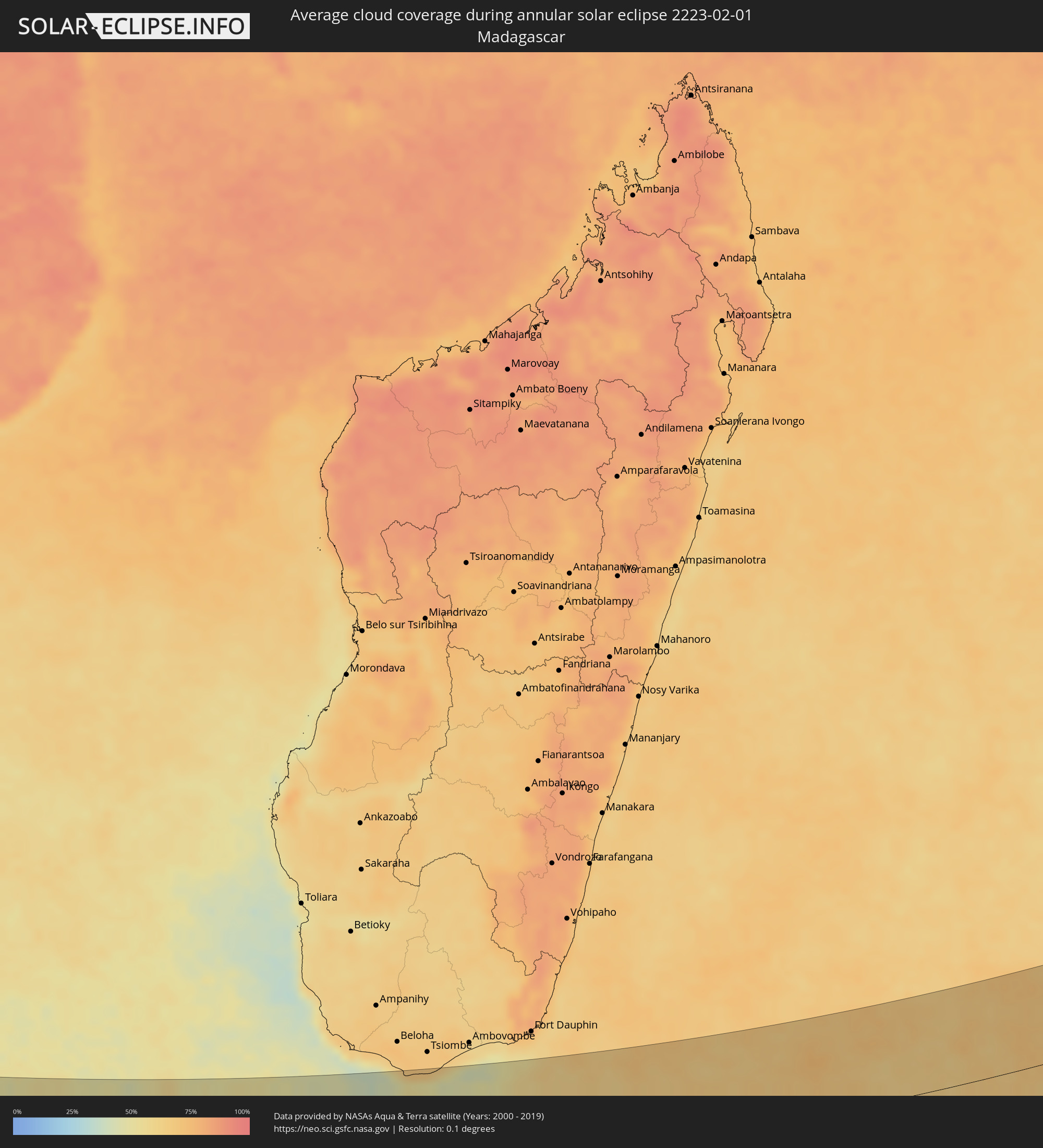 Madagascar
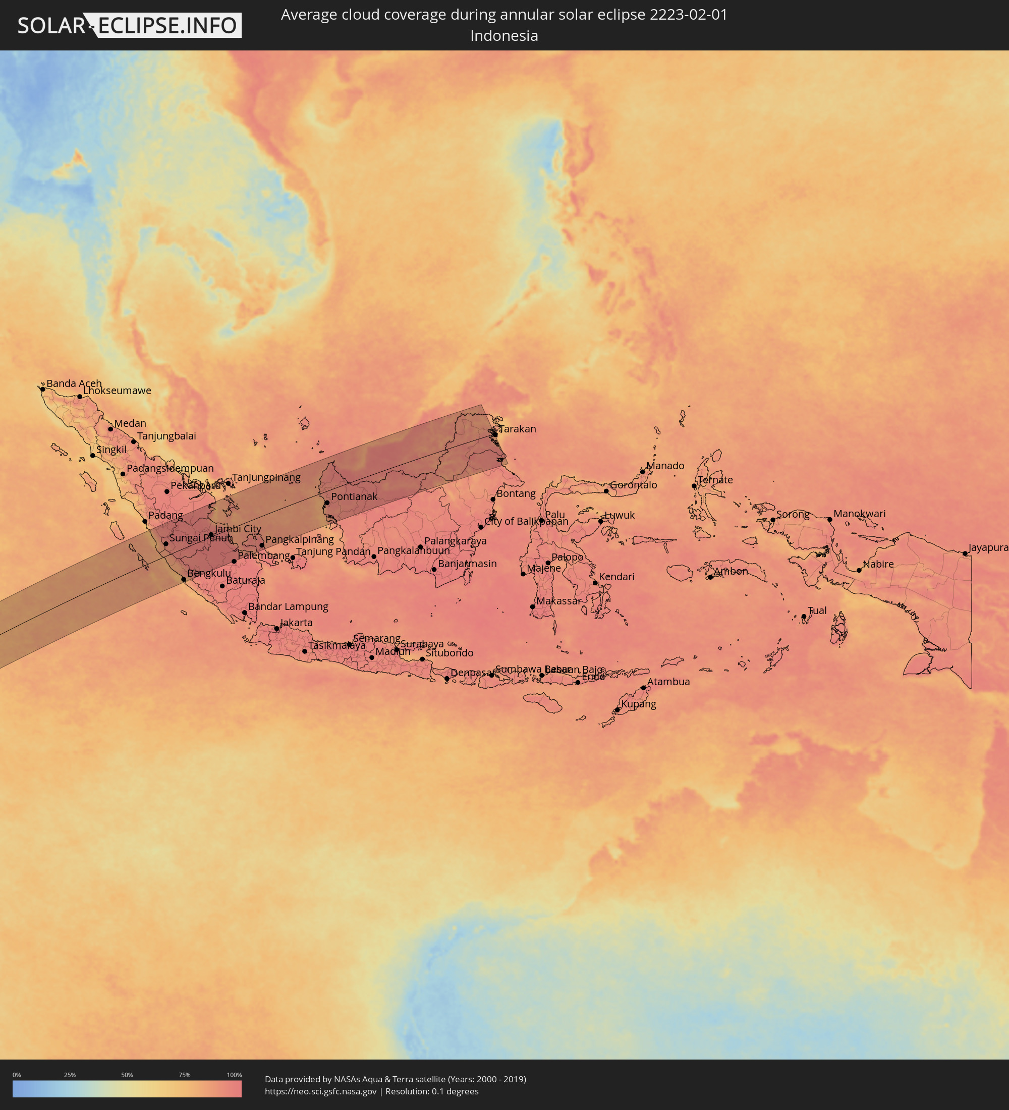 Indonesia
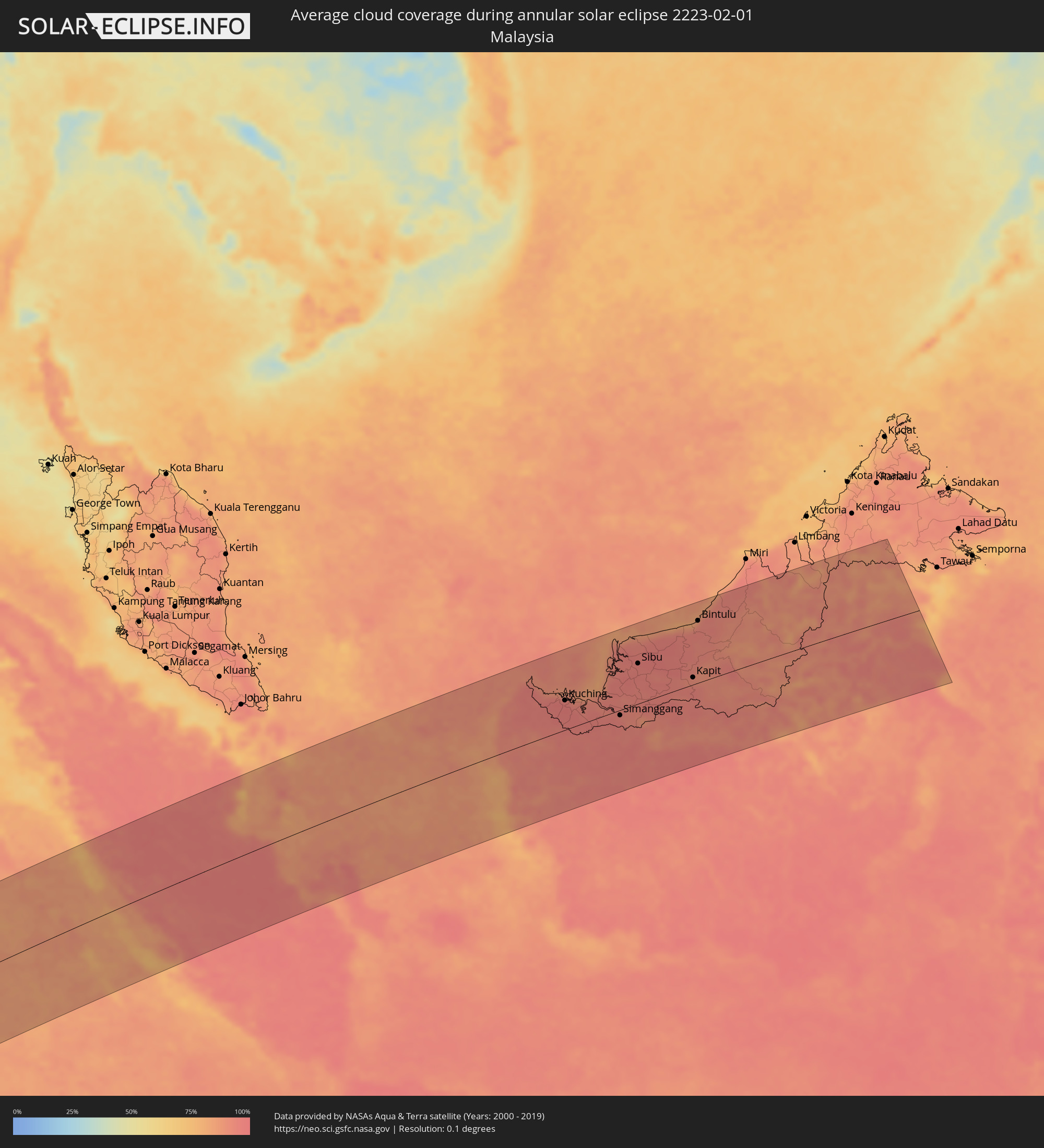 Malaysia
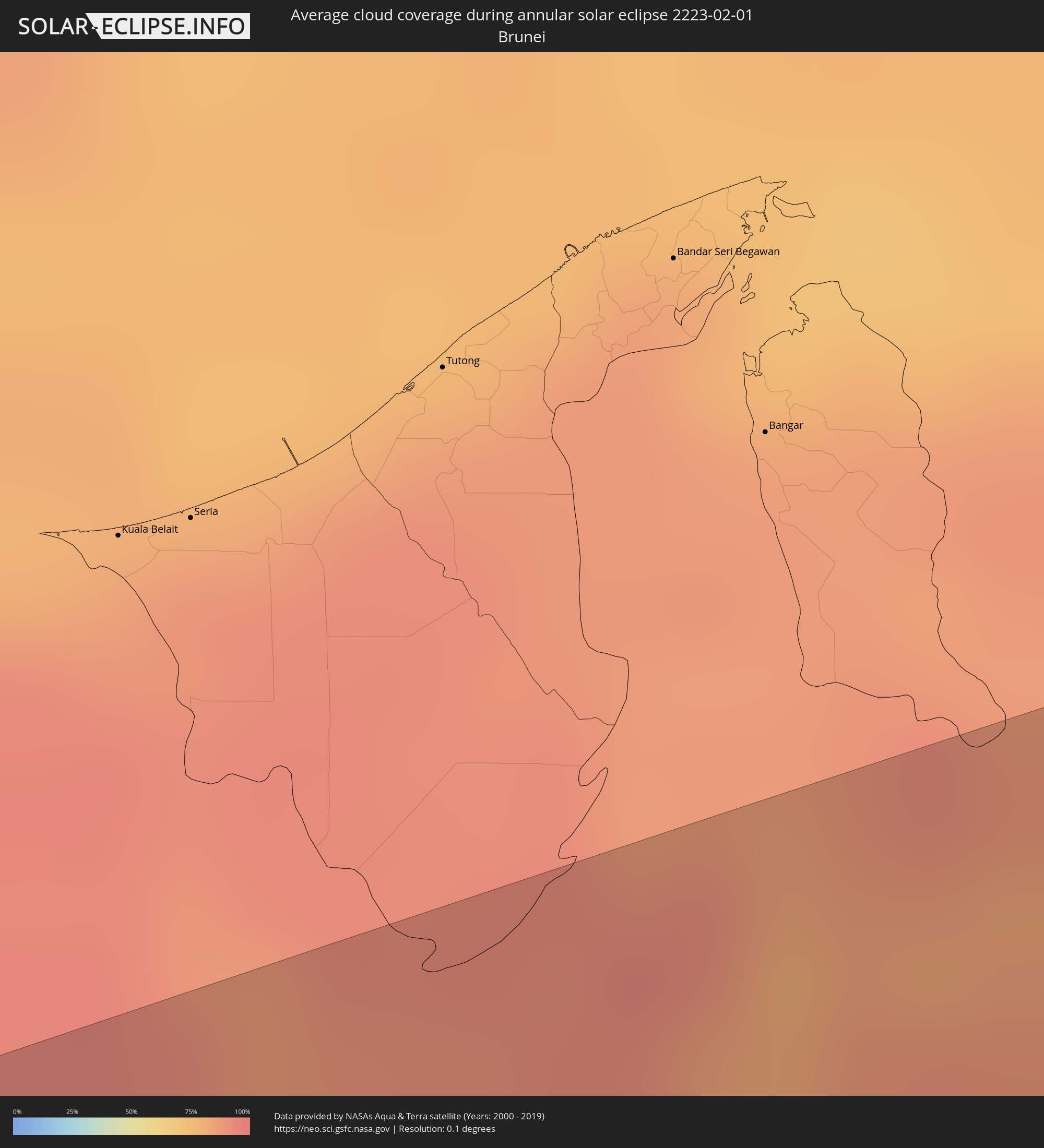 Brunei
Cities inside the path of the eclipse
The following table shows all locations with a population of more than 5,000 inside the eclipse path. Cities which have more than 100,000 inhabitants are marked bold. A click at the locations opens a detailed map.
| City | Type | Eclipse duration | Local time of max. eclipse | Distance to central line | Ø Cloud coverage |
|
Jamestown, Saint Helena
|
annular | - | 06:23:38 UTC+00:00 | 116 km | 76% |
|
Walvis Bay, Erongo
|
annular | - | 08:34:57 UTC+02:00 | 1 km | 40% |
|
Swakopmund, Erongo
|
annular | - | 08:34:45 UTC+02:00 | 29 km | 61% |
|
Usakos, Erongo
|
annular | - | 08:35:09 UTC+02:00 | 131 km | 30% |
|
Karibib, Erongo
|
annular | - | 08:35:18 UTC+02:00 | 145 km | 31% |
|
Otjimbingwe, Erongo
|
annular | - | 08:35:54 UTC+02:00 | 108 km | 28% |
|
Windhoek, Khomas
|
annular | - | 08:36:57 UTC+02:00 | 111 km | 46% |
|
Rehoboth, Hardap
|
annular | - | 08:37:33 UTC+02:00 | 30 km | 30% |
|
Mariental, Hardap
|
annular | - | 08:39:29 UTC+02:00 | 90 km | 28% |
|
Tshabong, Kgalagadi
|
annular | - | 08:45:51 UTC+02:00 | 136 km | 33% |
|
Letlhakeng, Kweneng
|
annular | - | 08:47:56 UTC+02:00 | 132 km | 56% |
|
Kanye, Ngwaketsi
|
annular | - | 08:49:02 UTC+02:00 | 43 km | 50% |
|
Mosopa, Ngwaketsi
|
annular | - | 08:49:01 UTC+02:00 | 66 km | 51% |
|
Molepolole, Kweneng
|
annular | - | 08:48:52 UTC+02:00 | 108 km | 51% |
|
Thamaga, Kweneng
|
annular | - | 08:49:08 UTC+02:00 | 80 km | 49% |
|
Janeng, South-East
|
annular | - | 08:49:42 UTC+02:00 | 1 km | 48% |
|
Lobatse, South-East
|
annular | - | 08:49:45 UTC+02:00 | 22 km | 50% |
|
Otse, South-East
|
annular | - | 08:49:41 UTC+02:00 | 46 km | 49% |
|
Gabane, Kweneng
|
annular | - | 08:49:30 UTC+02:00 | 85 km | 49% |
|
Metsemotlhaba, Kweneng
|
annular | - | 08:49:27 UTC+02:00 | 98 km | 51% |
|
Mogoditshane, Kweneng
|
annular | - | 08:49:36 UTC+02:00 | 91 km | 49% |
|
Ramotswa, South-East
|
annular | - | 08:49:47 UTC+02:00 | 64 km | 50% |
|
Kopong, South-East
|
annular | - | 08:49:31 UTC+02:00 | 107 km | 50% |
|
Gaborone, South-East
|
annular | - | 08:49:41 UTC+02:00 | 89 km | 48% |
|
Mochudi, Kgatleng
|
annular | - | 08:49:54 UTC+02:00 | 120 km | 48% |
|
Klerksdorp, North-West
|
annular | - | 08:52:33 UTC+02:00 | 137 km | 46% |
|
Potchefstroom, North-West
|
annular | - | 08:53:08 UTC+02:00 | 114 km | 46% |
|
Rustenburg, North-West
|
annular | - | 08:52:34 UTC+02:00 | 4 km | 52% |
|
Carletonville, Gauteng
|
annular | - | 08:53:21 UTC+02:00 | 70 km | 48% |
|
Westonaria, Gauteng
|
annular | - | 08:53:43 UTC+02:00 | 61 km | 50% |
|
Krugersdorp, Gauteng
|
annular | - | 08:53:46 UTC+02:00 | 33 km | 52% |
|
Brits, North-West
|
annular | - | 08:53:26 UTC+02:00 | 17 km | 48% |
|
Sasolburg, Orange Free State
|
annular | - | 08:54:22 UTC+02:00 | 112 km | 48% |
|
Soweto, Gauteng
|
annular | - | 08:54:02 UTC+02:00 | 51 km | 49% |
|
Vereeniging, Gauteng
|
annular | - | 08:54:27 UTC+02:00 | 94 km | 48% |
|
Diepsloot, Gauteng
|
annular | - | 08:54:03 UTC+02:00 | 12 km | 51% |
|
Johannesburg, Gauteng
|
annular | - | 08:54:18 UTC+02:00 | 41 km | 53% |
|
Mabopane, Gauteng
|
annular | - | 08:53:53 UTC+02:00 | 37 km | 48% |
|
Pretoria, Gauteng
|
annular | - | 08:54:13 UTC+02:00 | 12 km | 52% |
|
Tembisa, Gauteng
|
annular | - | 08:54:28 UTC+02:00 | 15 km | 54% |
|
Warmbaths, Limpopo
|
annular | - | 08:53:46 UTC+02:00 | 108 km | 48% |
|
Benoni, Gauteng
|
annular | - | 08:54:46 UTC+02:00 | 35 km | 51% |
|
Nigel, Gauteng
|
annular | - | 08:55:12 UTC+02:00 | 59 km | 49% |
|
Delmas, Mpumalanga
|
annular | - | 08:55:21 UTC+02:00 | 24 km | 48% |
|
eMbalenhle, Mpumalanga
|
annular | - | 08:56:18 UTC+02:00 | 60 km | 47% |
|
Witbank, Mpumalanga
|
annular | - | 08:56:08 UTC+02:00 | 15 km | 50% |
|
Middelburg, Mpumalanga
|
annular | - | 08:56:29 UTC+02:00 | 30 km | 46% |
|
Bethal, Mpumalanga
|
annular | - | 08:56:57 UTC+02:00 | 45 km | 45% |
|
Piet Retief, Mpumalanga
|
annular | - | 08:59:48 UTC+02:00 | 85 km | 51% |
|
Nelspruit, Mpumalanga
|
annular | - | 08:59:06 UTC+02:00 | 86 km | 58% |
|
Mbabane, Hhohho
|
annular | - | 08:59:57 UTC+02:00 | 5 km | 53% |
|
Malkerns, Manzini
|
annular | - | 09:00:13 UTC+02:00 | 32 km | 57% |
|
Lobamba, Hhohho
|
annular | - | 09:00:11 UTC+02:00 | 20 km | 54% |
|
Nhlangano, Shiselweni
|
annular | - | 09:00:37 UTC+02:00 | 92 km | 53% |
|
Piggs Peak, Hhohho
|
annular | - | 08:59:57 UTC+02:00 | 36 km | 55% |
|
Hlatikulu, Shiselweni
|
annular | - | 09:00:44 UTC+02:00 | 74 km | 55% |
|
Manzini, Manzini
|
annular | - | 09:00:33 UTC+02:00 | 21 km | 55% |
|
Hluti, Shiselweni
|
annular | - | 09:01:29 UTC+02:00 | 97 km | 60% |
|
Mhlume, Lubombo
|
annular | - | 09:01:11 UTC+02:00 | 36 km | 60% |
|
Big Bend, Lubombo
|
annular | - | 09:01:50 UTC+02:00 | 49 km | 58% |
|
Siteki, Lubombo
|
annular | - | 09:01:38 UTC+02:00 | 8 km | 65% |
|
Ressano Garcia, Maputo
|
annular | - | 09:01:06 UTC+02:00 | 103 km | 62% |
|
Matola, Maputo
|
annular | - | 09:02:22 UTC+02:00 | 52 km | 61% |
|
Maputo, Maputo City
|
annular | - | 09:02:37 UTC+02:00 | 53 km | 52% |
|
Sungai Penuh, Jambi
|
annular | - | 17:12:58 UTC+07:00 | 57 km | 91% |
|
Bengkulu, Bengkulu
|
annular | - | 17:11:45 UTC+07:00 | 159 km | 83% |
|
Curup, Bengkulu
|
annular | - | 17:12:10 UTC+07:00 | 137 km | 86% |
|
Lubuklinggau, South Sumatra
|
annular | - | 17:12:28 UTC+07:00 | 134 km | 94% |
|
Bejubang Dua, Jambi
|
annular | - | 17:13:59 UTC+07:00 | 0 km | 96% |
|
Kuala Tungkal, Jambi
|
annular | - | 17:14:50 UTC+07:00 | 94 km | 88% |
|
Mendaha, Jambi
|
annular | - | 17:14:43 UTC+07:00 | 68 km | 93% |
|
Jambi City, Jambi
|
annular | - | 17:14:15 UTC+07:00 | 7 km | 97% |
|
Simpang, Jambi
|
annular | - | 17:14:41 UTC+07:00 | 21 km | 96% |
|
Muntok, Bangka–Belitung Islands
|
annular | - | 17:14:22 UTC+07:00 | 107 km | 93% |
|
Pangkalpinang, Bangka–Belitung Islands
|
annular | - | 17:14:35 UTC+07:00 | 153 km | 96% |
|
Sungailiat, Bangka–Belitung Islands
|
annular | - | 17:14:48 UTC+07:00 | 125 km | 95% |
|
Sungai Raya, West Kalimantan
|
annular | - | 17:17:16 UTC+07:00 | 29 km | 86% |
|
Pemangkat, West Kalimantan
|
annular | - | 17:17:36 UTC+07:00 | 75 km | 92% |
|
Singkawang, West Kalimantan
|
annular | - | 17:17:26 UTC+07:00 | 48 km | 92% |
|
Pontianak, West Kalimantan
|
annular | - | 17:16:49 UTC+07:00 | 64 km | 95% |
|
Kuching, Sarawak
|
annular | - | 18:17:59 UTC+08:00 | 63 km | 97% |
|
Simanggang, Sarawak
|
annular | - | 18:17:52 UTC+08:00 | 11 km | 95% |
|
Sarikei, Sarawak
|
annular | - | 18:18:24 UTC+08:00 | 78 km | 97% |
|
Sibu, Sarawak
|
annular | - | 18:18:31 UTC+08:00 | 86 km | 96% |
|
Kapit, Sarawak
|
annular | - | 18:18:21 UTC+08:00 | 15 km | 92% |
|
Bintulu, Sarawak
|
annular | - | 18:19:01 UTC+08:00 | 133 km | 88% |
|
Sembakung, East Kalimantan
|
annular | - | 18:18:58 UTC+08:00 | 57 km | 87% |
|
Tanjung Selor, North Kalimantan
|
annular | - | 18:18:27 UTC+08:00 | 52 km | 94% |