Annular solar eclipse of 11/10/2273
| Day of week: | Monday |
| Maximum duration of eclipse: | 09m34s |
| Maximum width of eclipse path: | 272 km |
| Saros cycle: | 147 |
| Coverage: | 92.8% |
| Magnitude: | 0.9278 |
| Gamma: | -0.0398 |
Wo kann man die Sonnenfinsternis vom 11/10/2273 sehen?
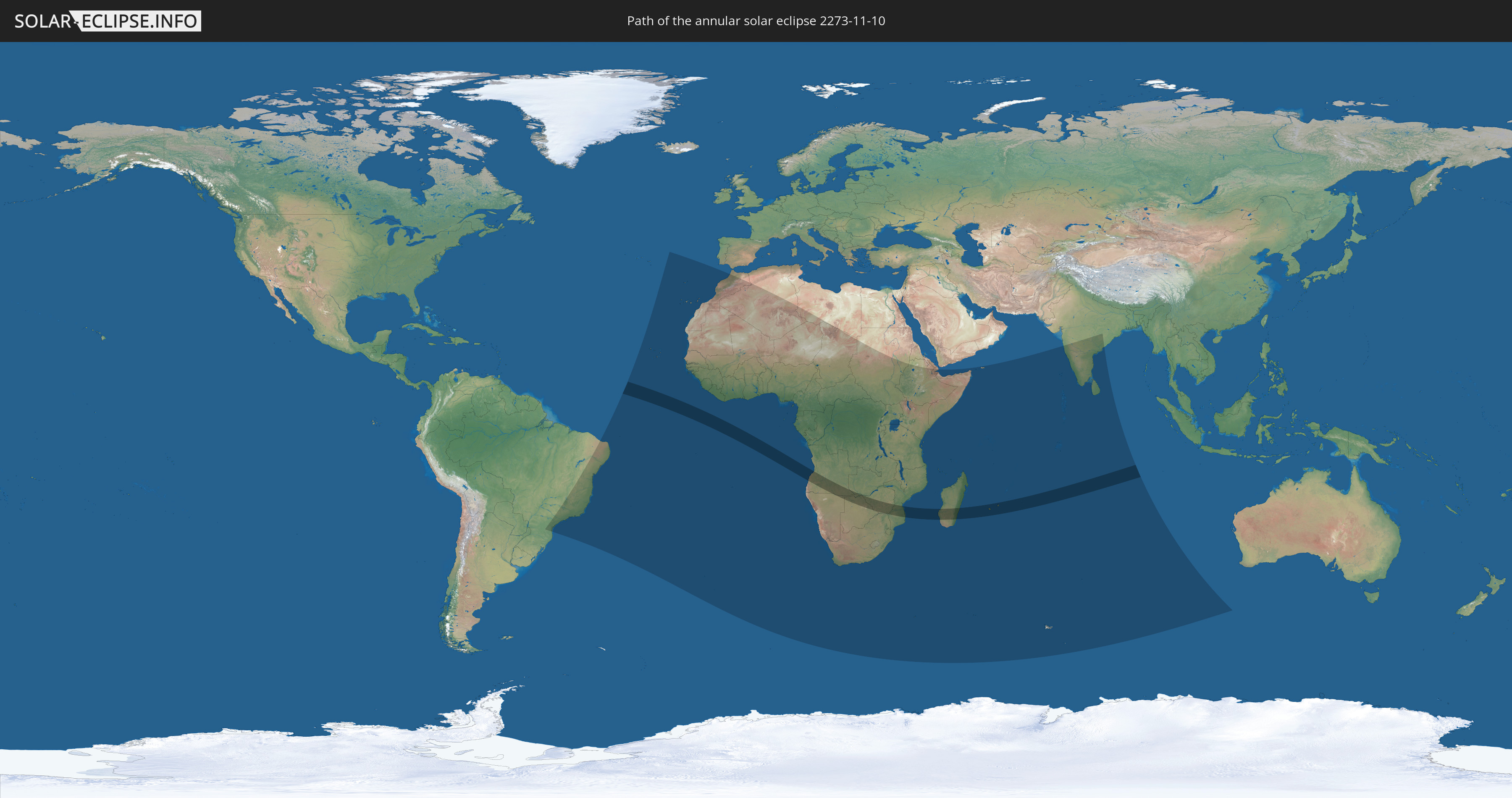
Die Sonnenfinsternis am 11/10/2273 kann man in 63 Ländern als partielle Sonnenfinsternis beobachten.
Der Finsternispfad verläuft durch 10 Länder. Nur in diesen Ländern ist sie als annular Sonnenfinsternis zu sehen.
In den folgenden Ländern ist die Sonnenfinsternis annular zu sehen
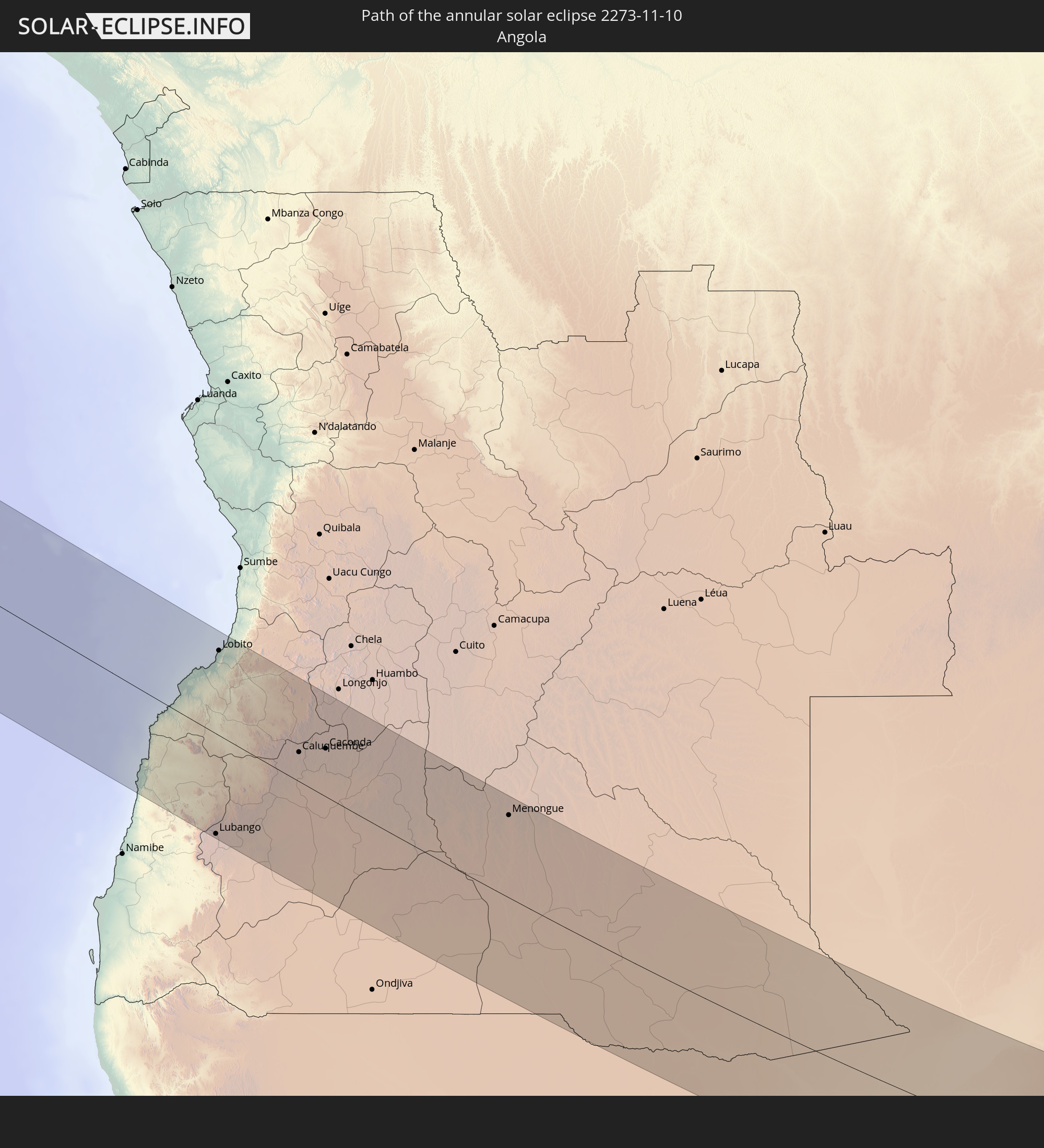 Angola
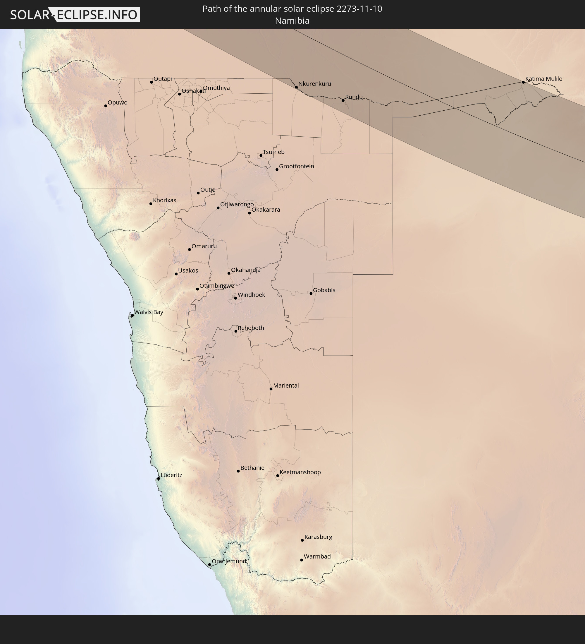 Namibia
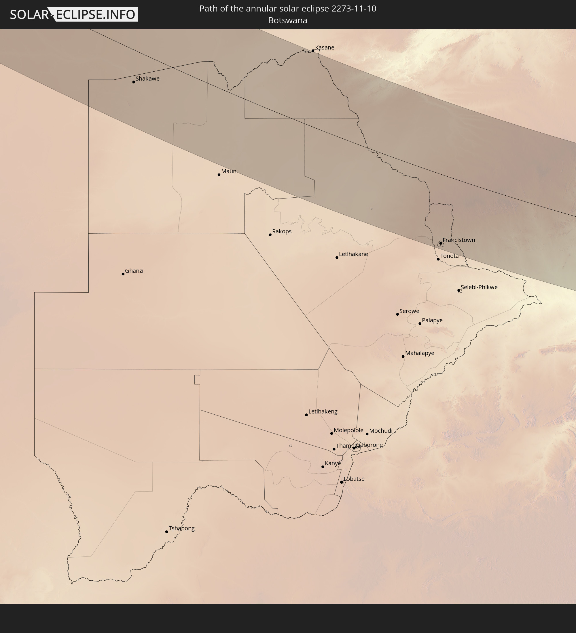 Botswana
 Zambia
 Zimbabwe
 Mozambique
 French Southern and Antarctic Lands
 Madagascar
 Réunion
 Mauritius
In den folgenden Ländern ist die Sonnenfinsternis partiell zu sehen
 Brazil
 Portugal
 Cabo Verde
 Spain
Spain
 Senegal
 Mauritania
 The Gambia
 Guinea-Bissau
 Guinea
 Saint Helena, Ascension and Tristan da Cunha
 Sierra Leone
 Morocco
 Mali
Mali
 Liberia
 Algeria
 Ivory Coast
 Burkina Faso
 Ghana
Ghana
 Togo
Togo
 Niger
Niger
 Benin
Benin
 Nigeria
 Equatorial Guinea
 São Tomé and Príncipe
 Cameroon
 Gabon
Gabon
 Libya
Libya
 Republic of the Congo
 Angola
 Namibia
 Democratic Republic of the Congo
 Chad
Chad
 Central African Republic
 South Africa
 Botswana
 Sudan
Sudan
 Zambia
 Zimbabwe
 Lesotho
 Rwanda
 Burundi
 Tanzania
 Uganda
 Mozambique
 Swaziland
 Malawi
 Ethiopia
 Kenya
Kenya
 French Southern and Antarctic Lands
 Somalia
 Djibouti
 Yemen
Yemen
 Madagascar
 Comoros
 Mayotte
 Seychelles
 Réunion
 Mauritius
 India
India
 British Indian Ocean Territory
 Heard Island and McDonald Islands
 Maldives
 Sri Lanka
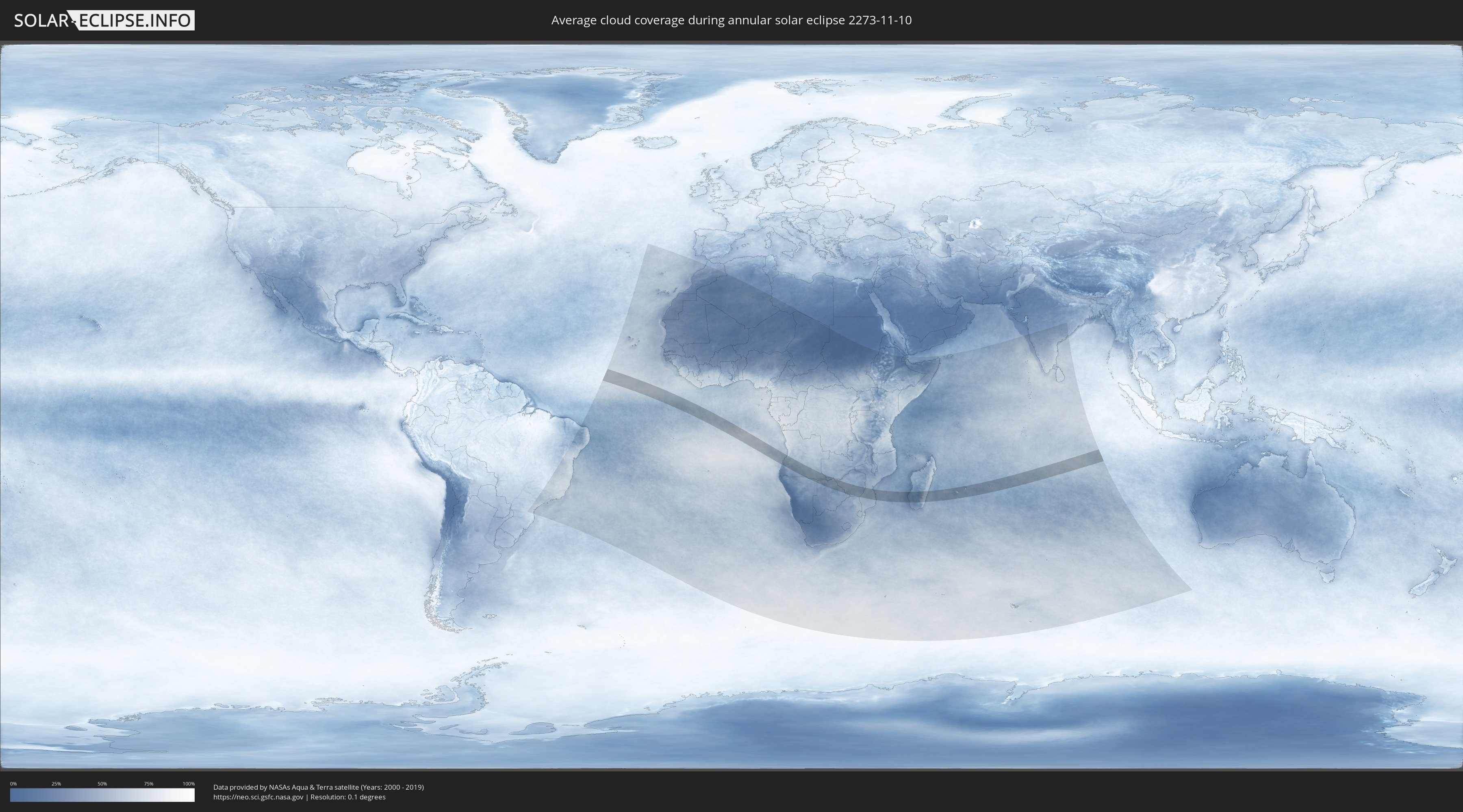
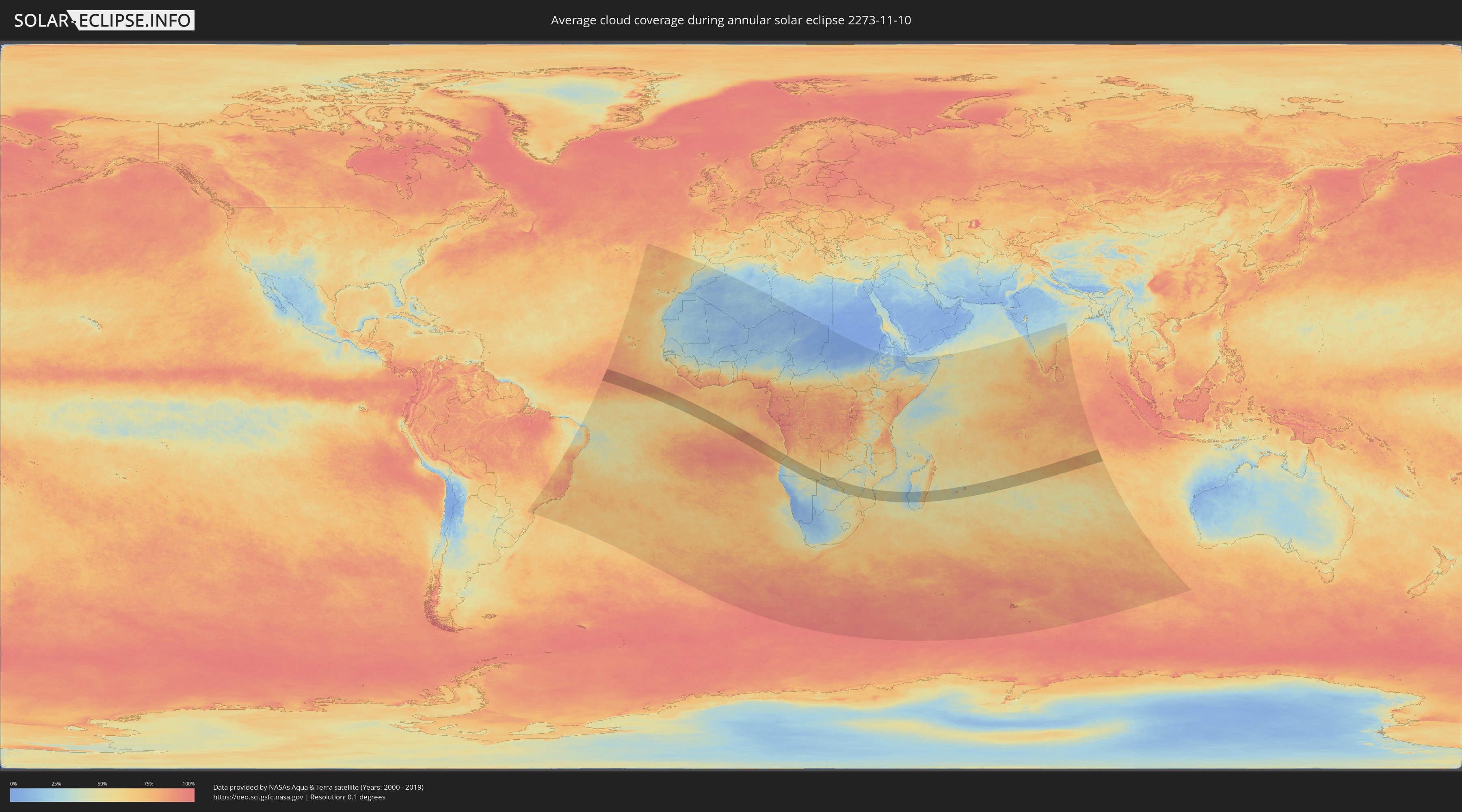
How will be the weather during the annular solar eclipse on 11/10/2273?
Where is the best place to see the annular solar eclipse of 11/10/2273?
The following maps show the average cloud coverage for the day of the annular solar eclipse.
With the help of these maps, it is possible to find the place along the eclipse path, which has the best
chance of a cloudless sky.
Nevertheless, you should consider local circumstances and inform about the weather of your chosen
observation site.
The data is provided by NASAs satellites
AQUA and TERRA.
The cloud maps are averaged over a period of 19 years (2000 - 2019).
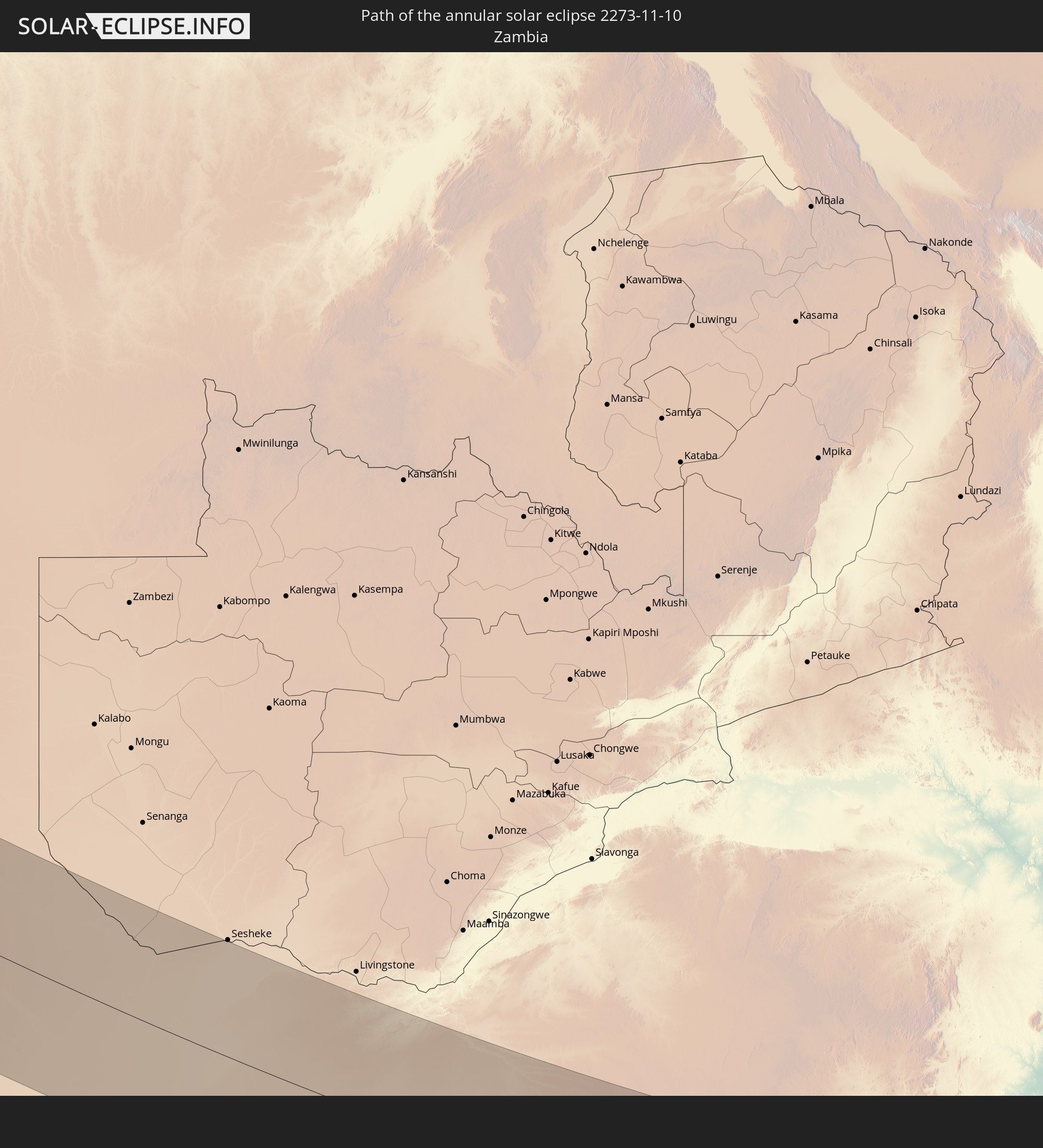
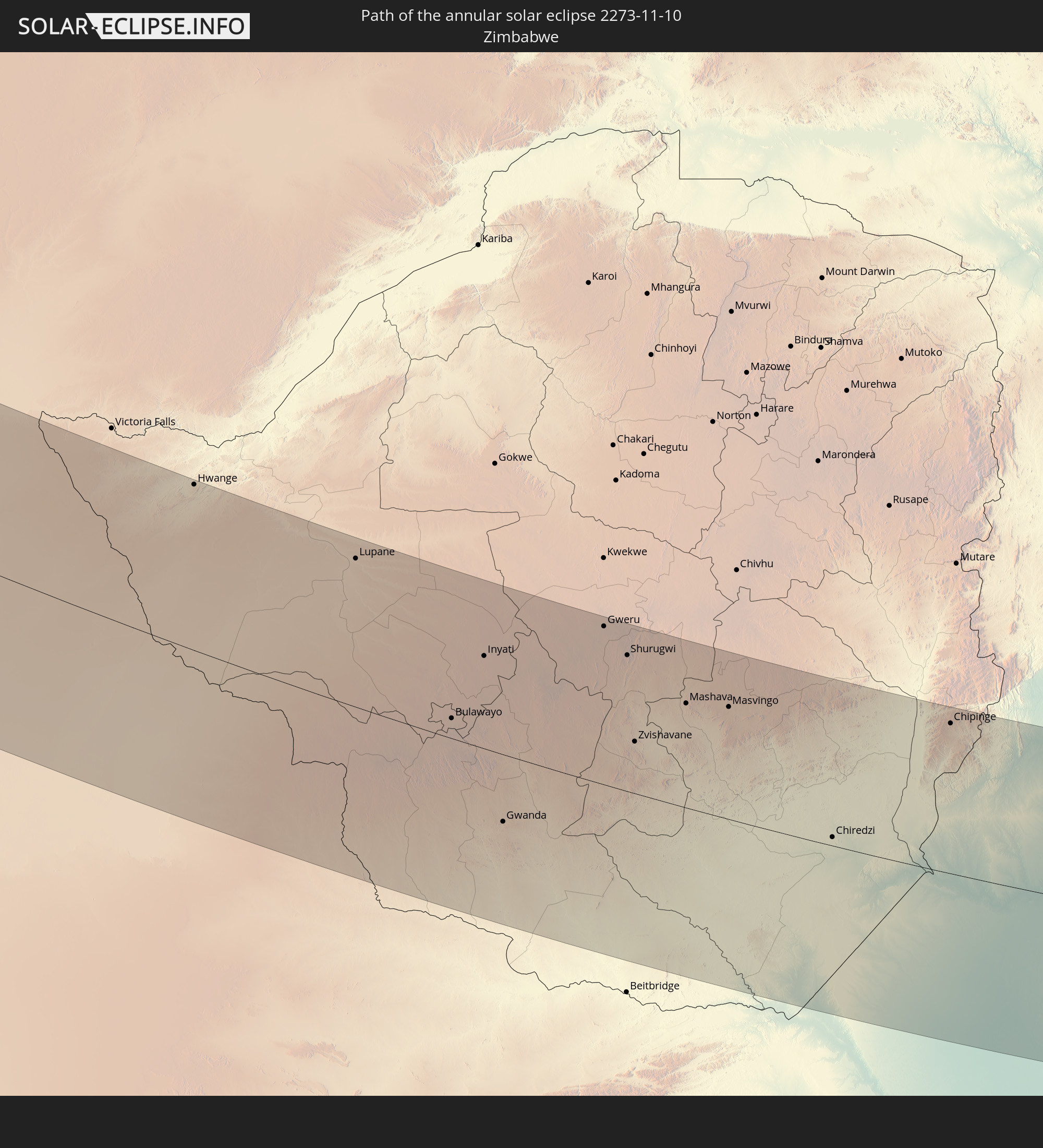
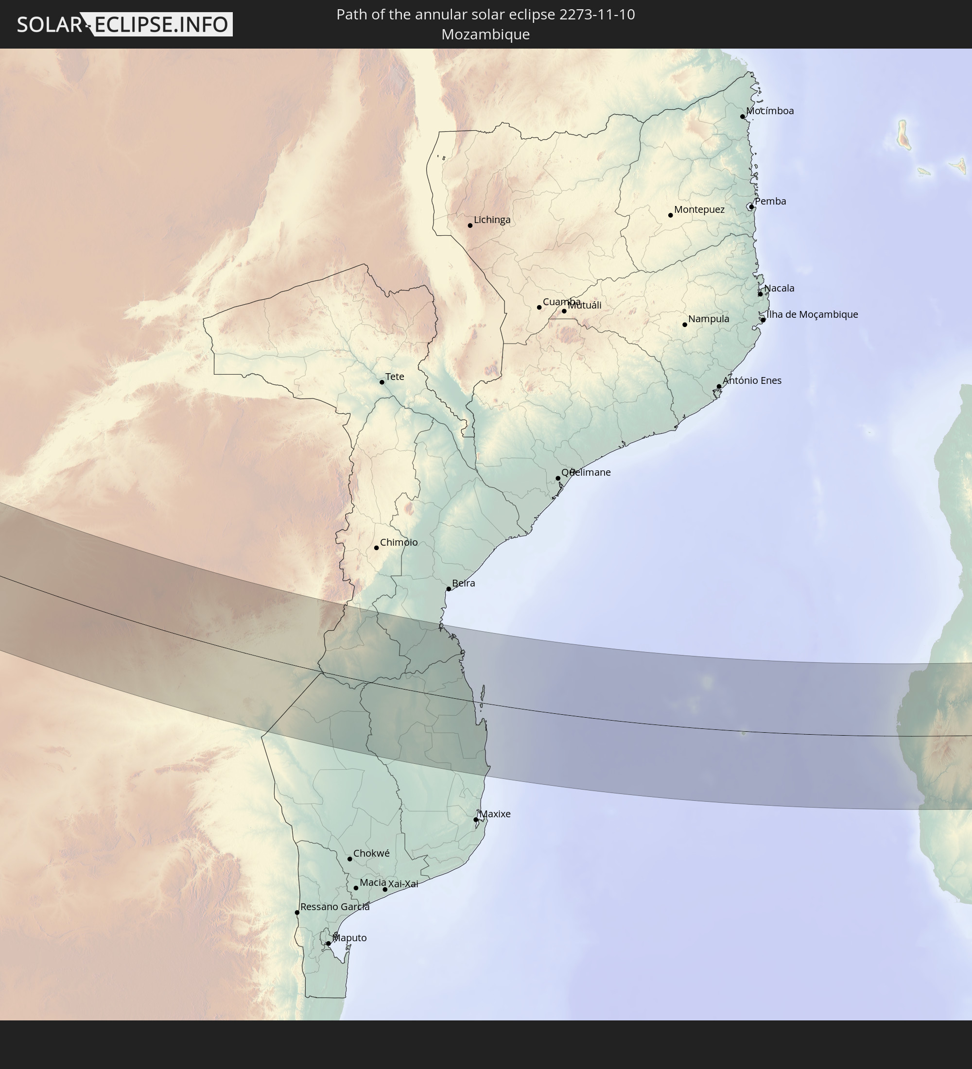
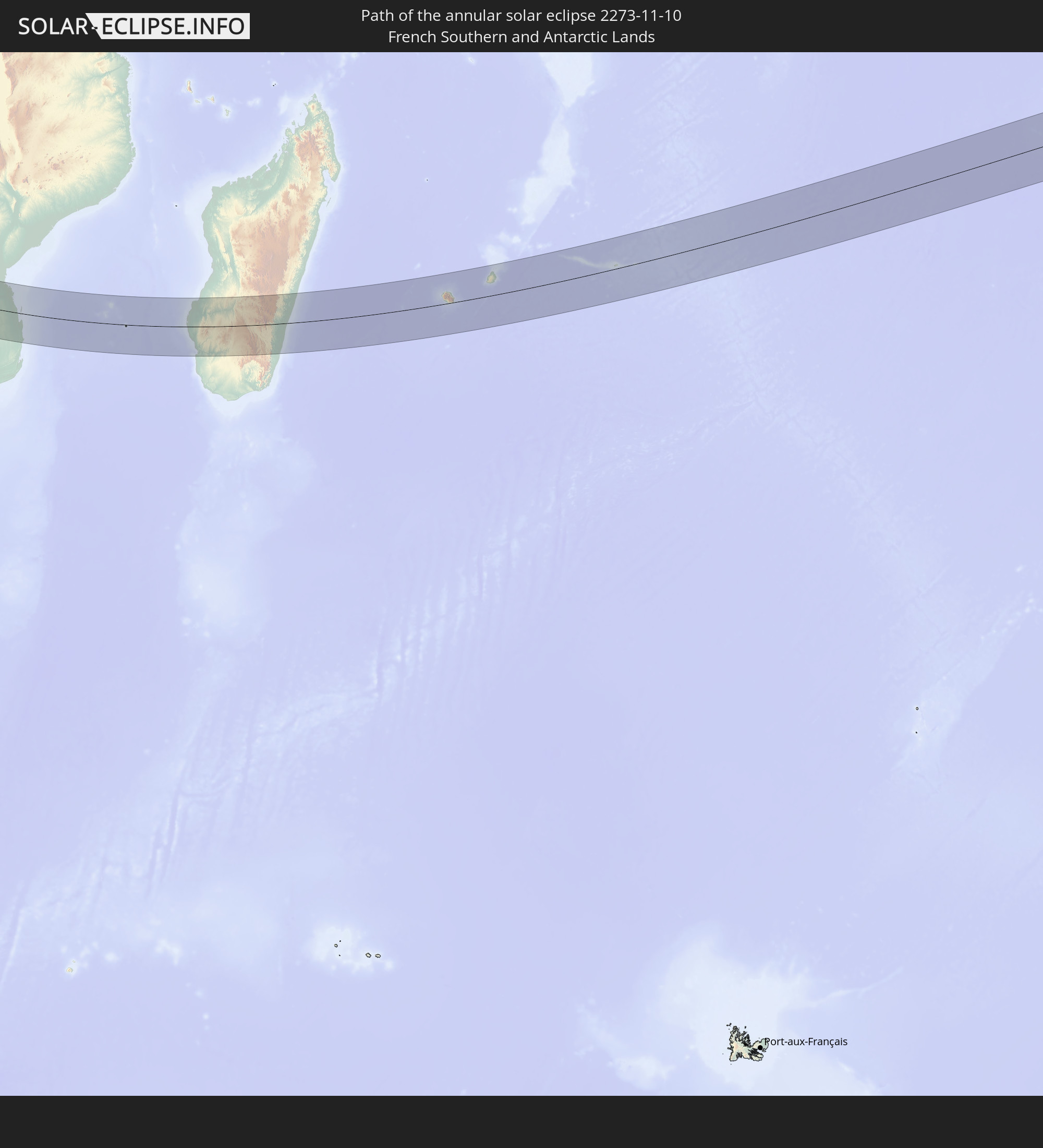
Detailed country maps
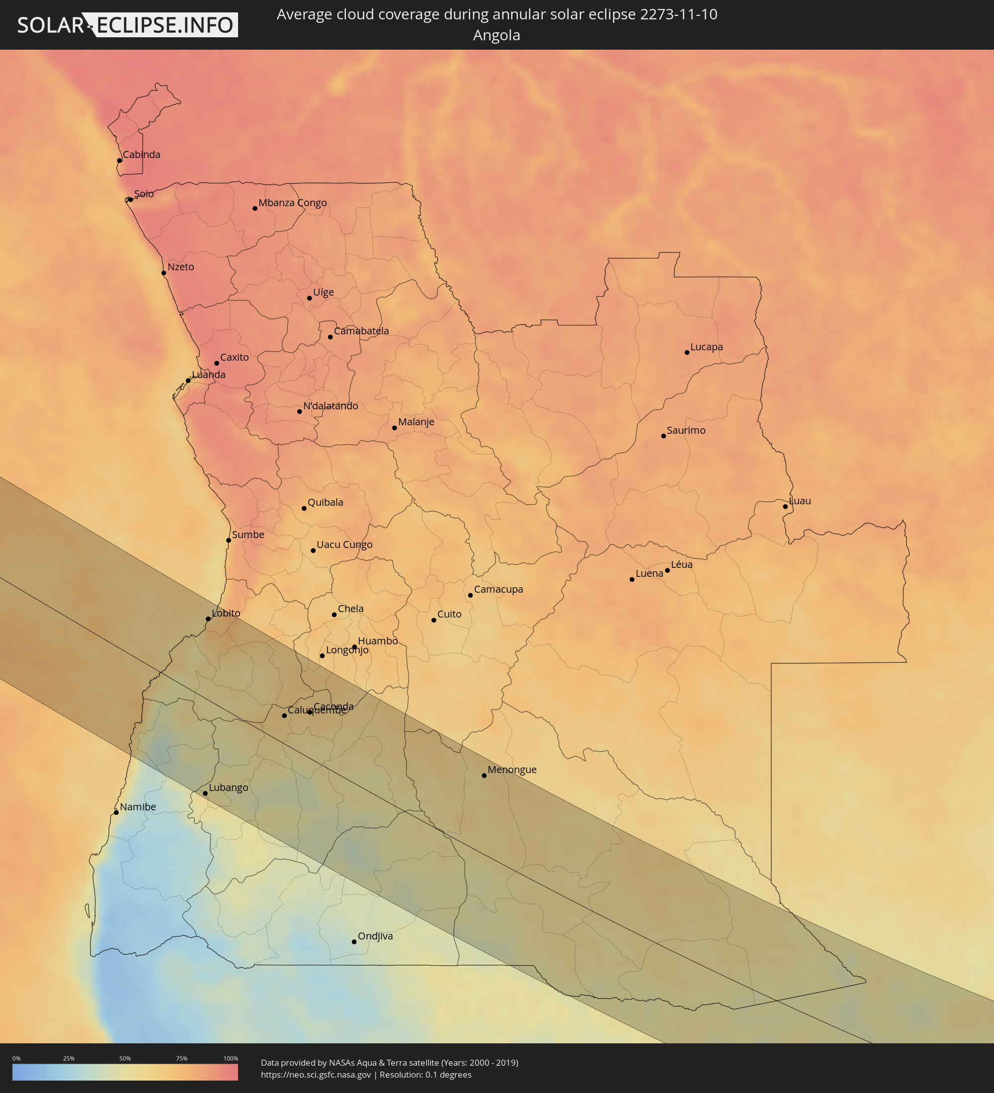 Angola
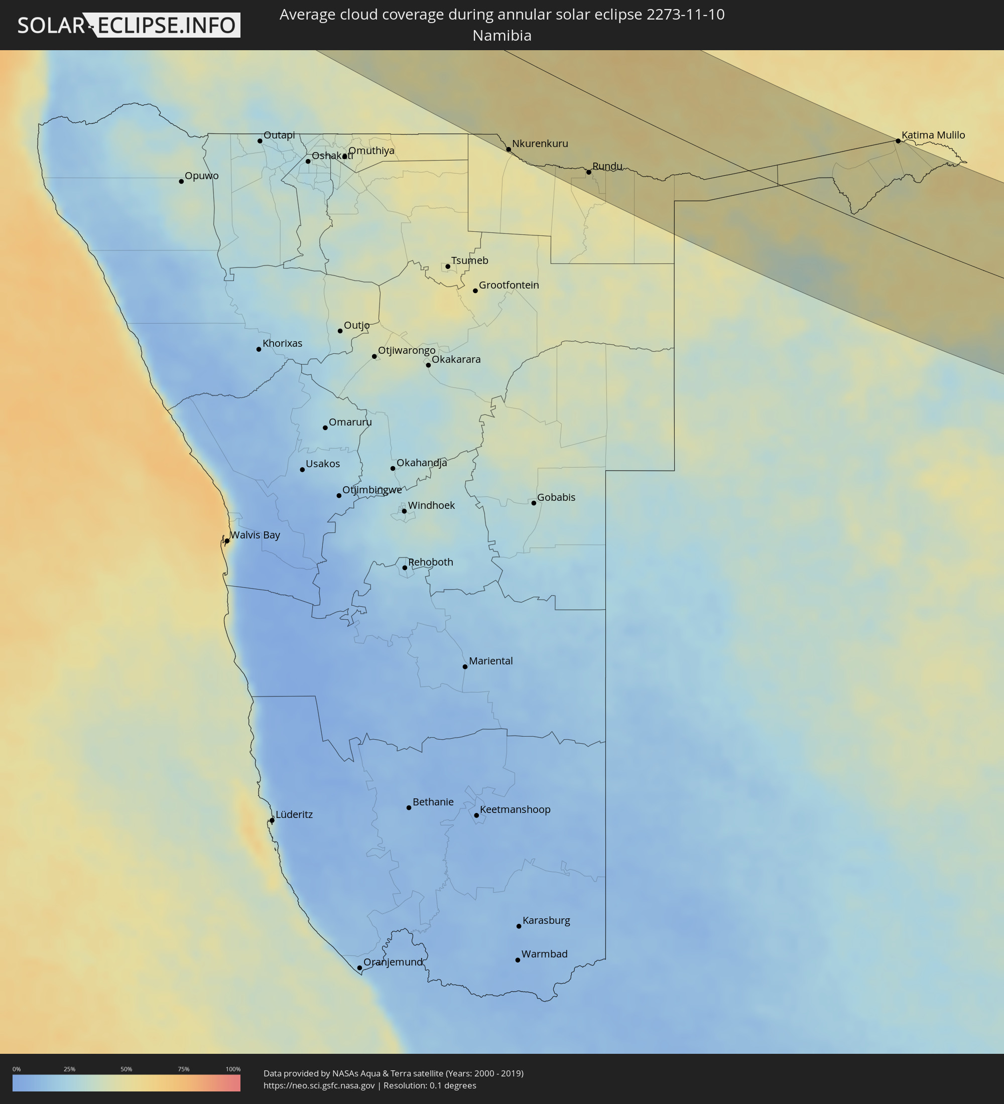 Namibia
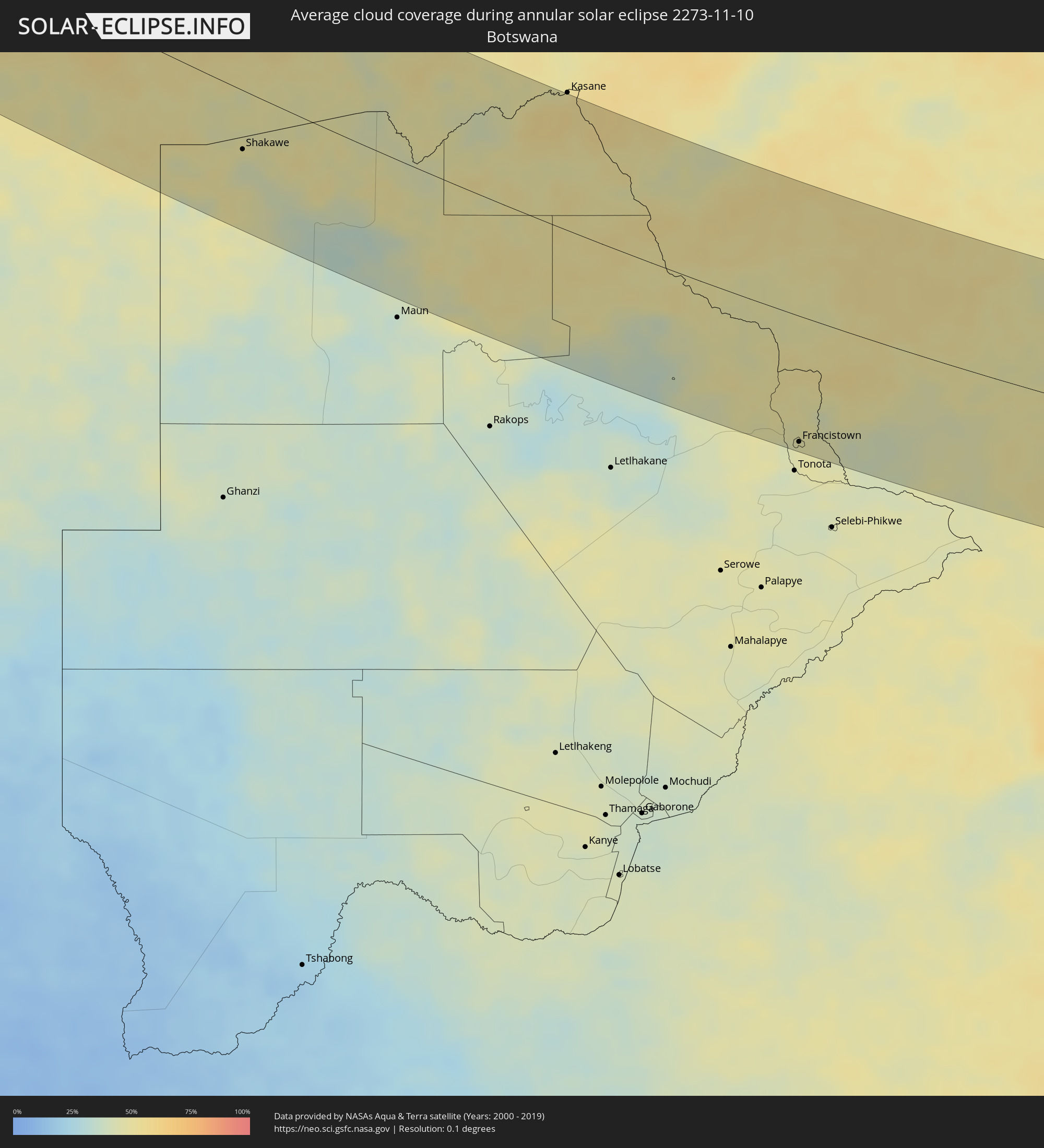 Botswana
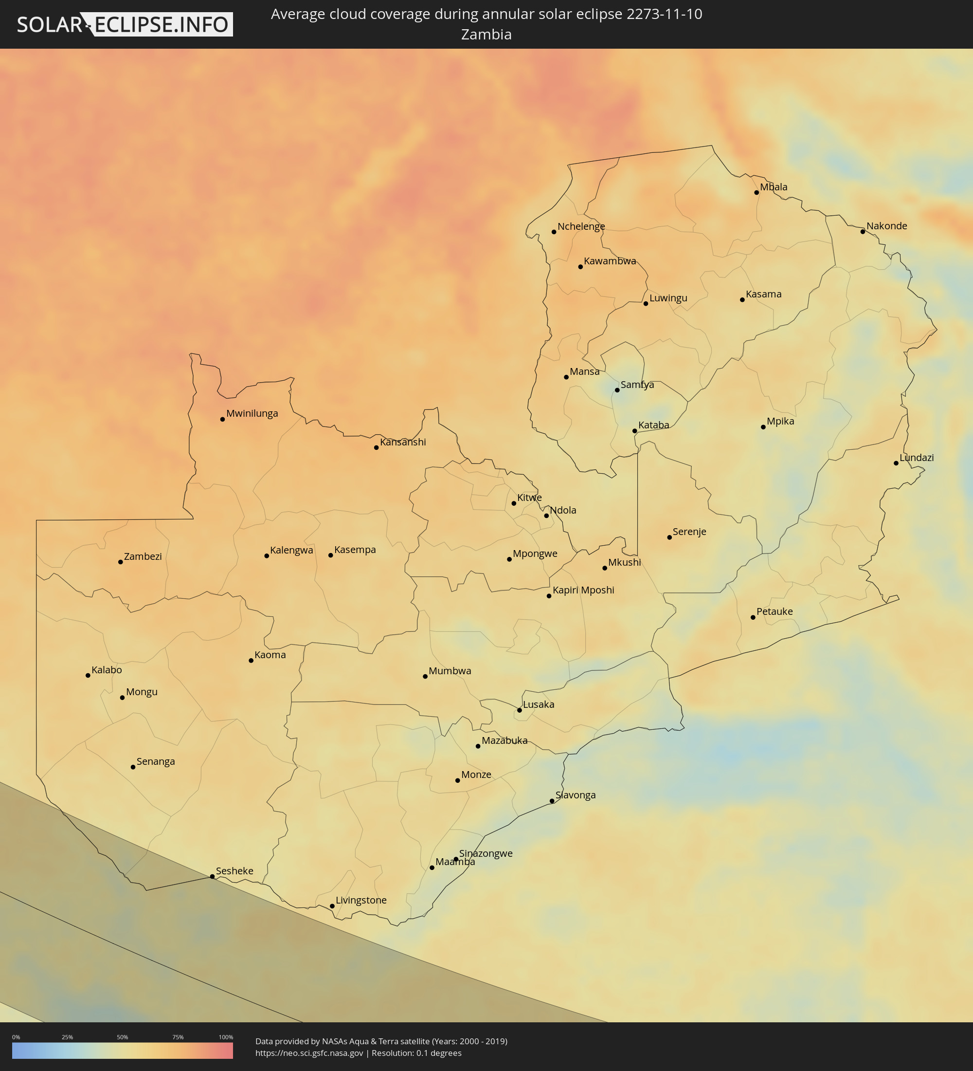 Zambia
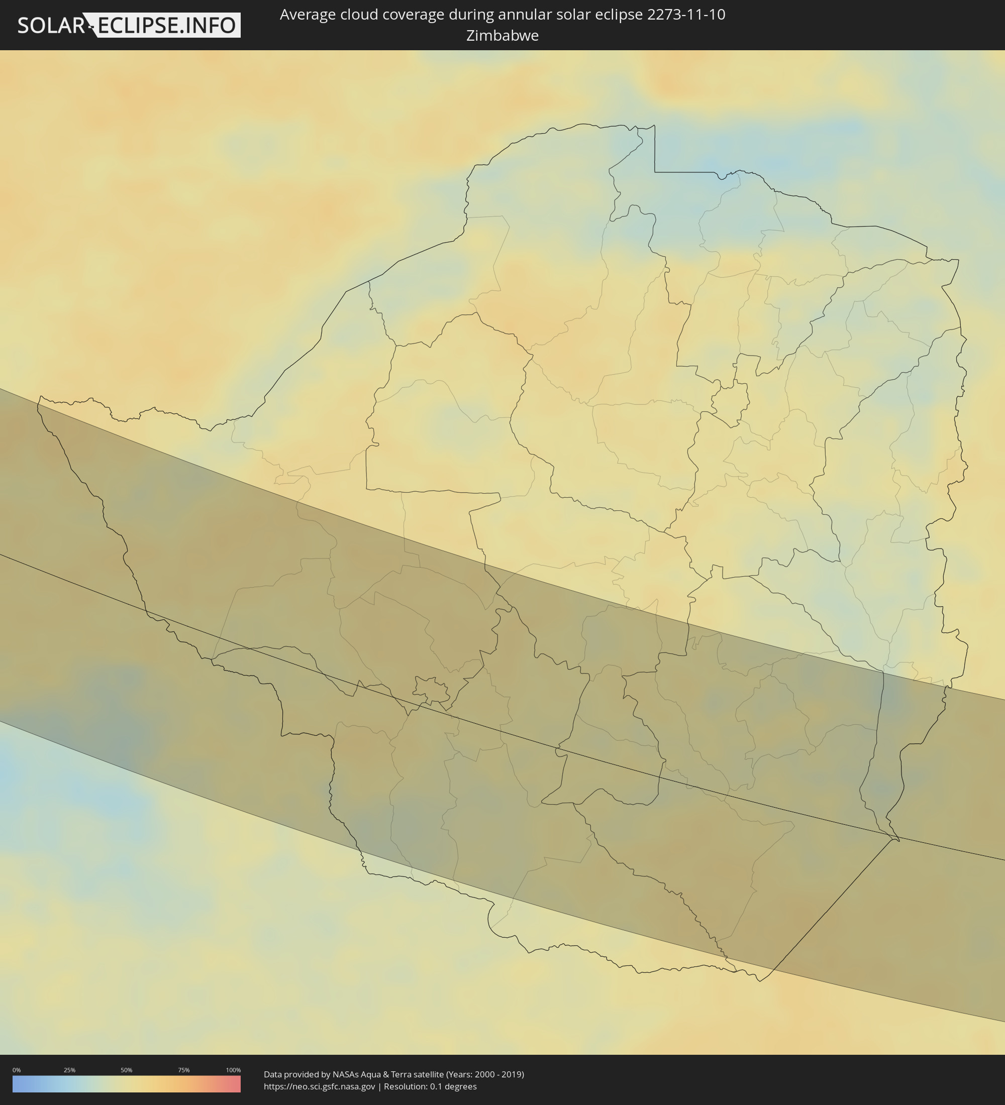 Zimbabwe
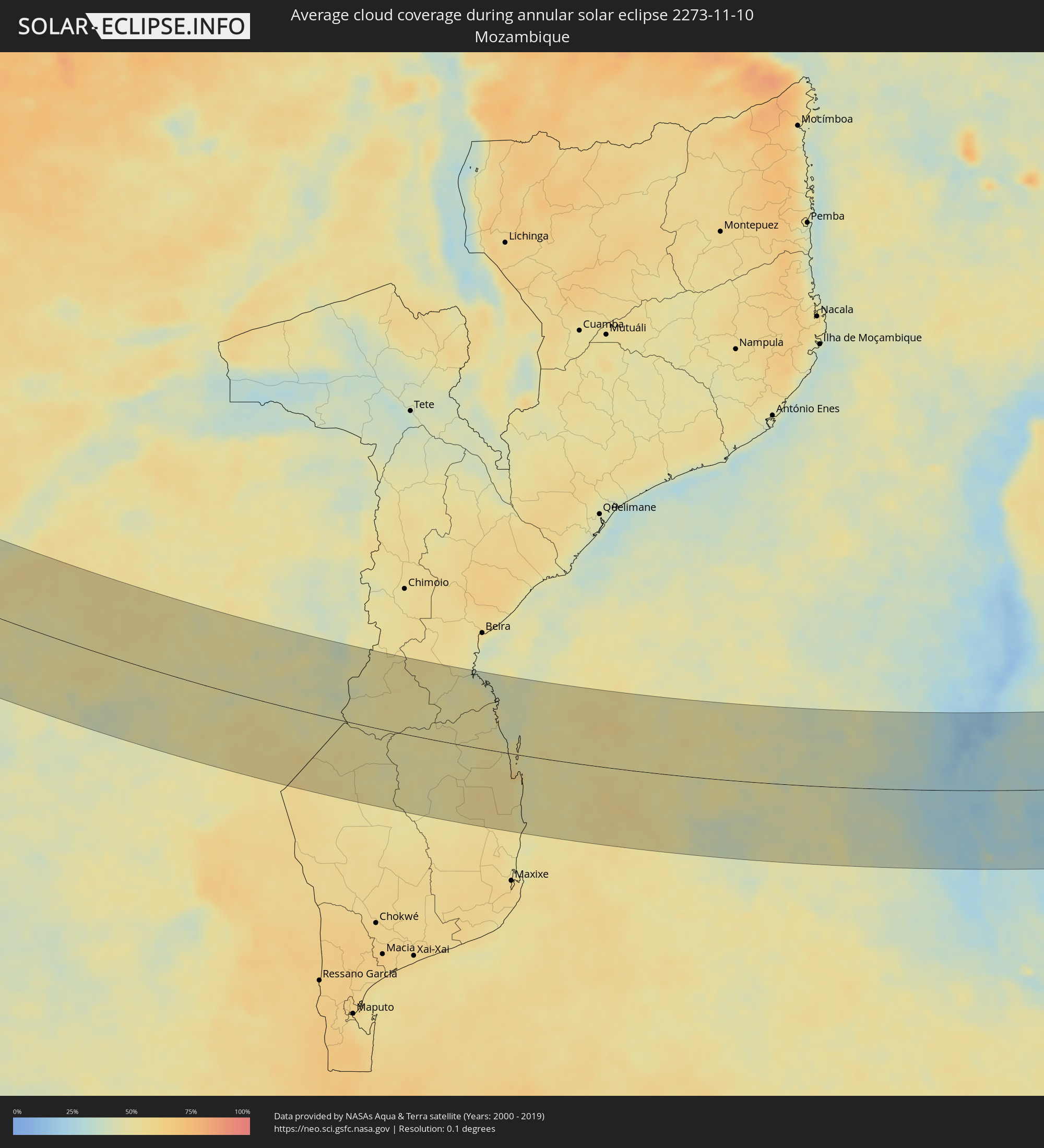 Mozambique
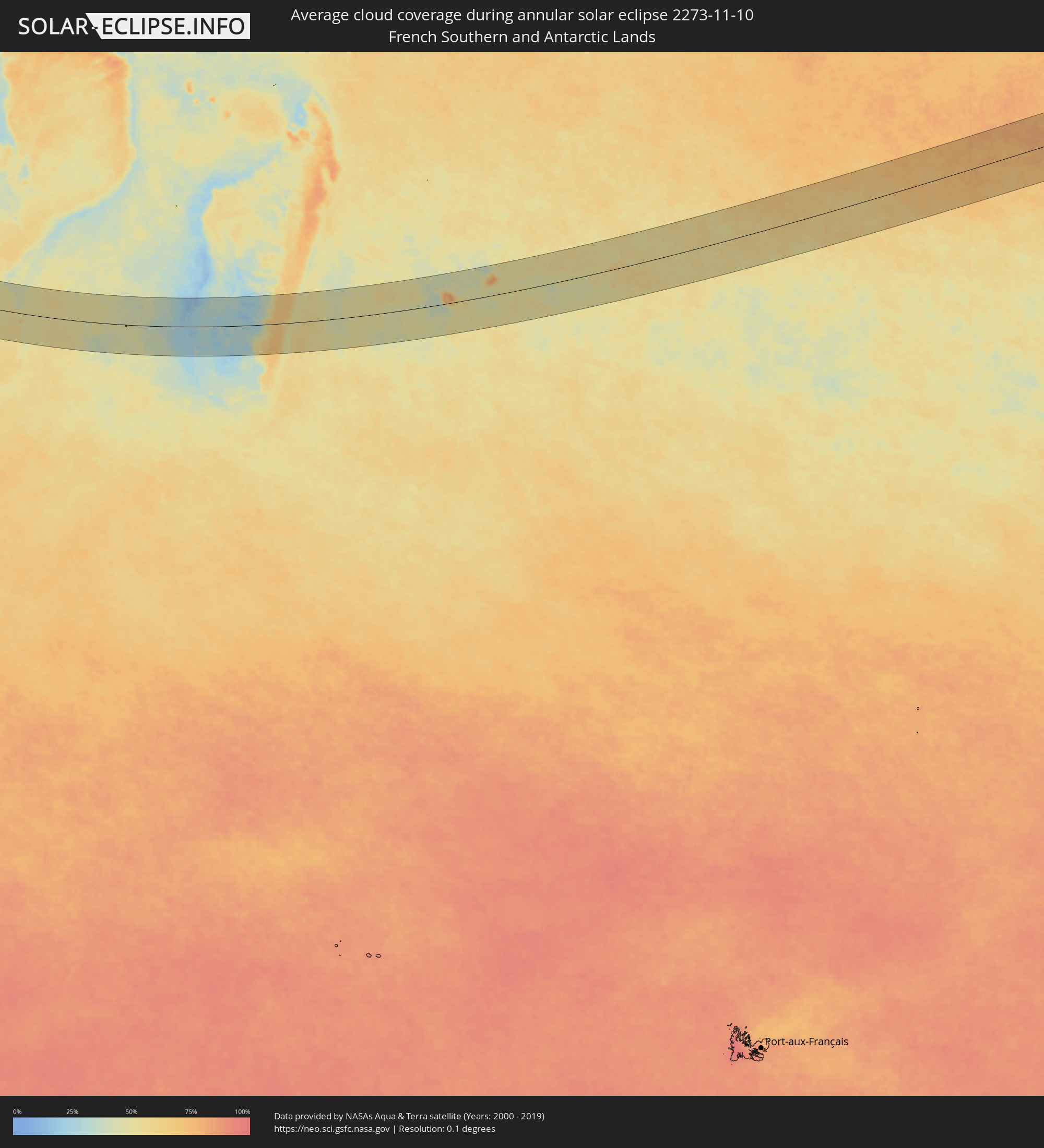 French Southern and Antarctic Lands
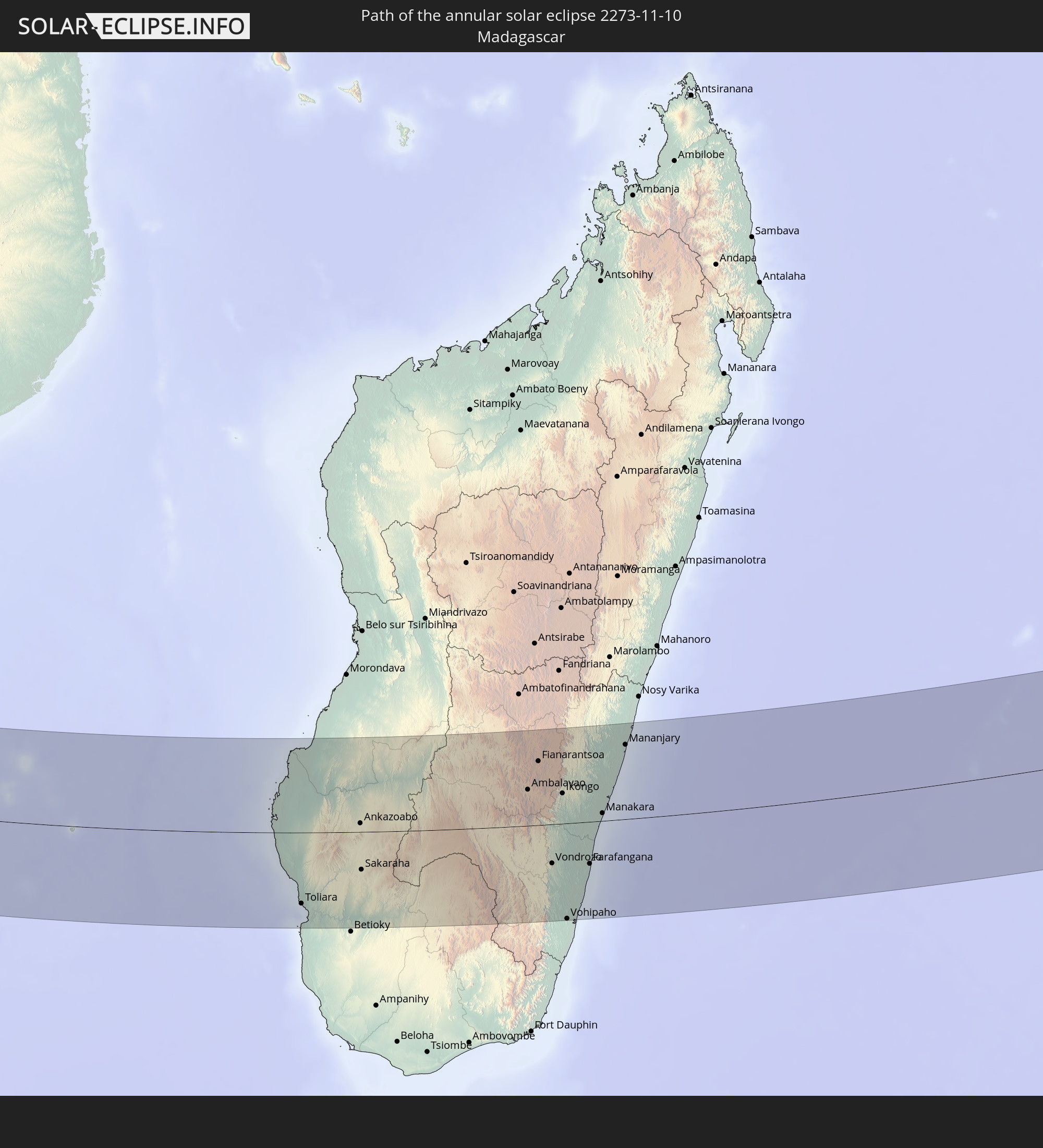
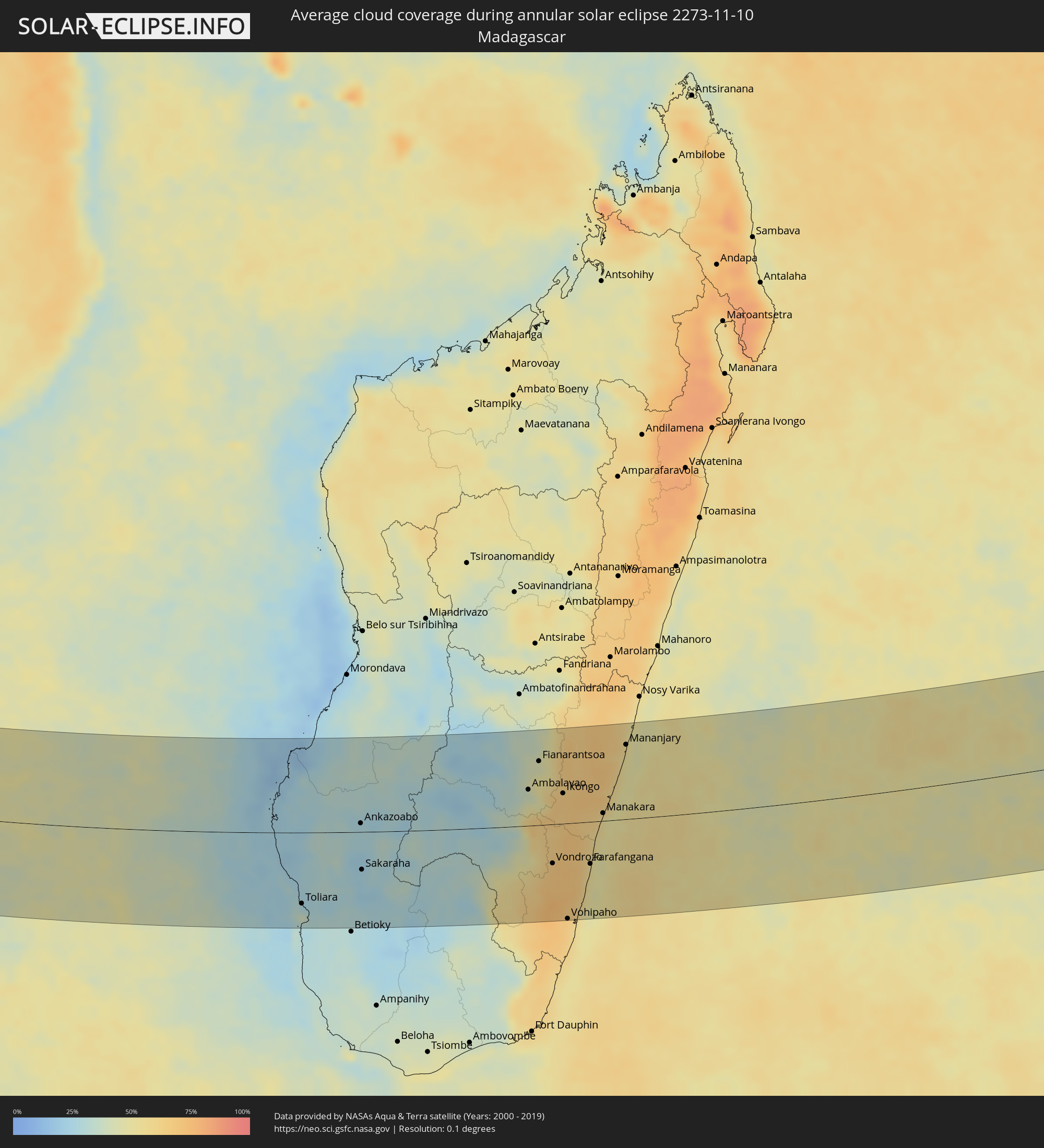 Madagascar
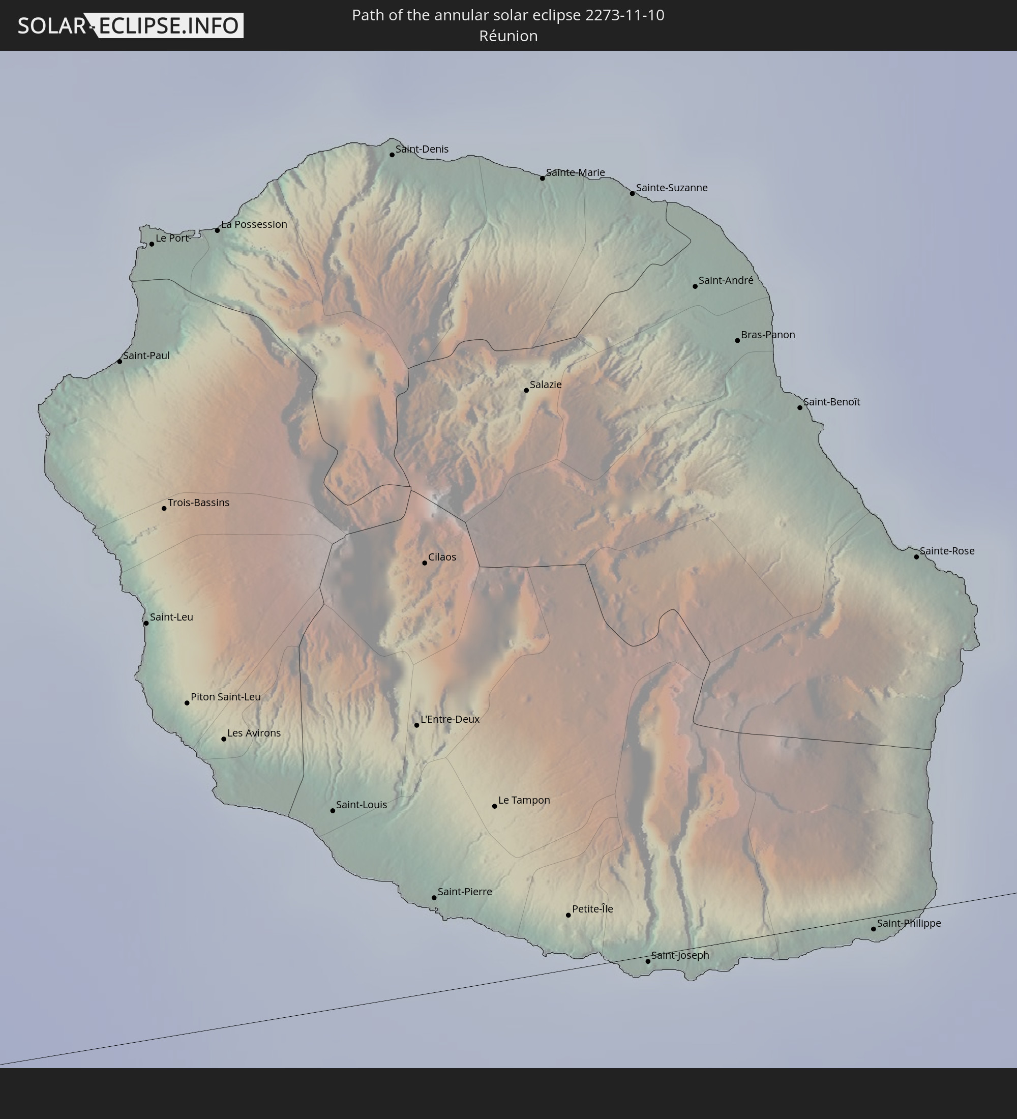
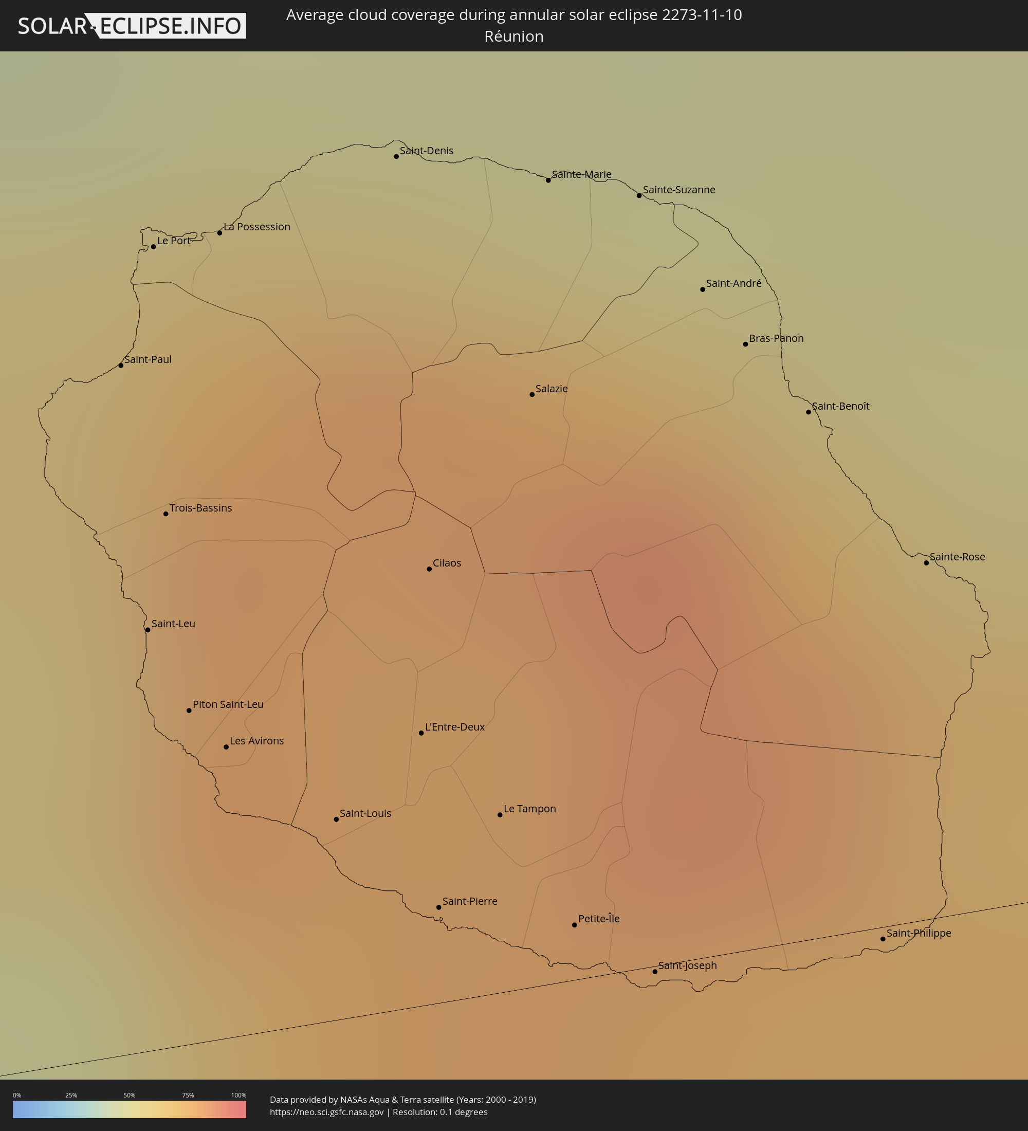 Réunion
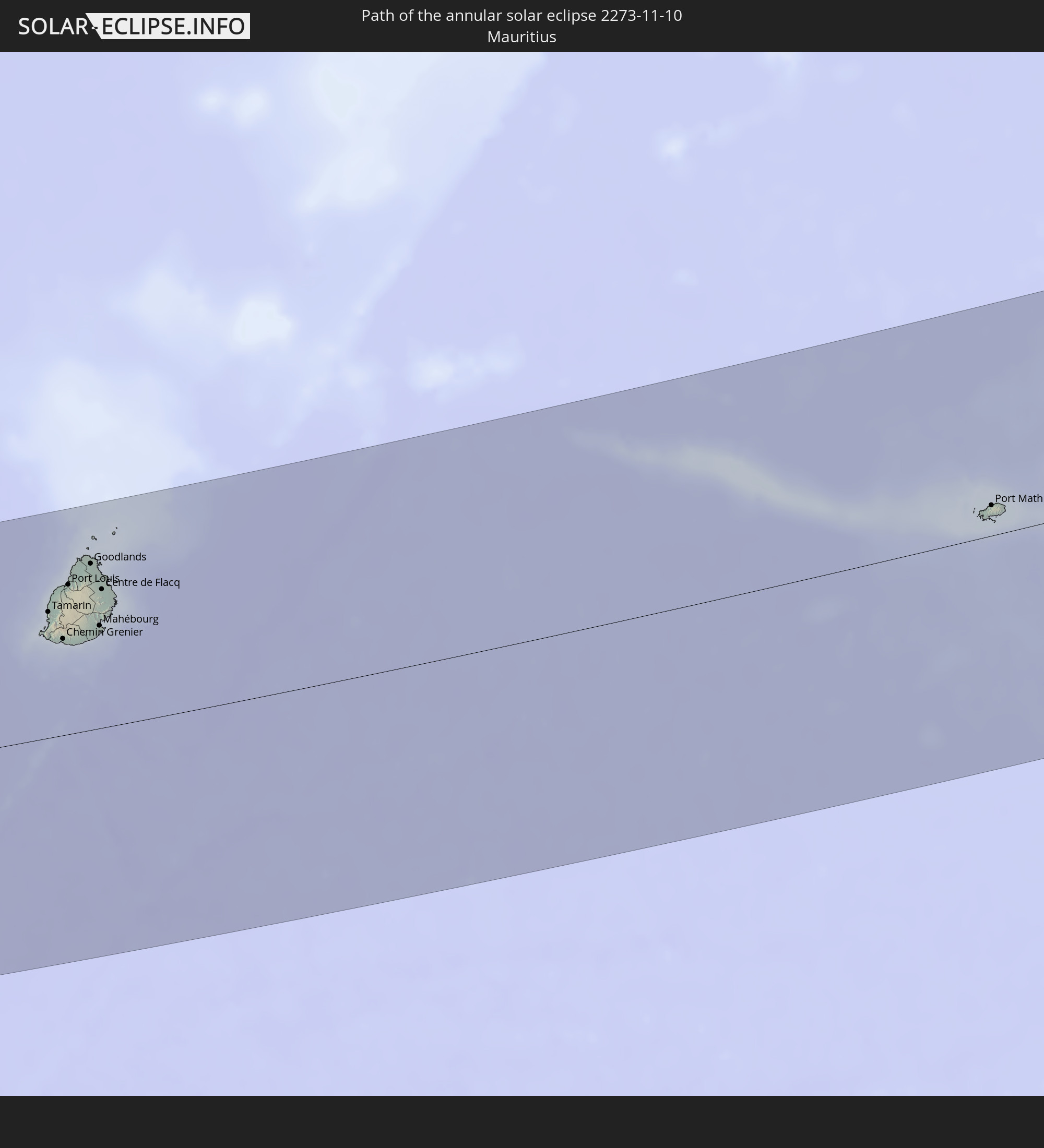
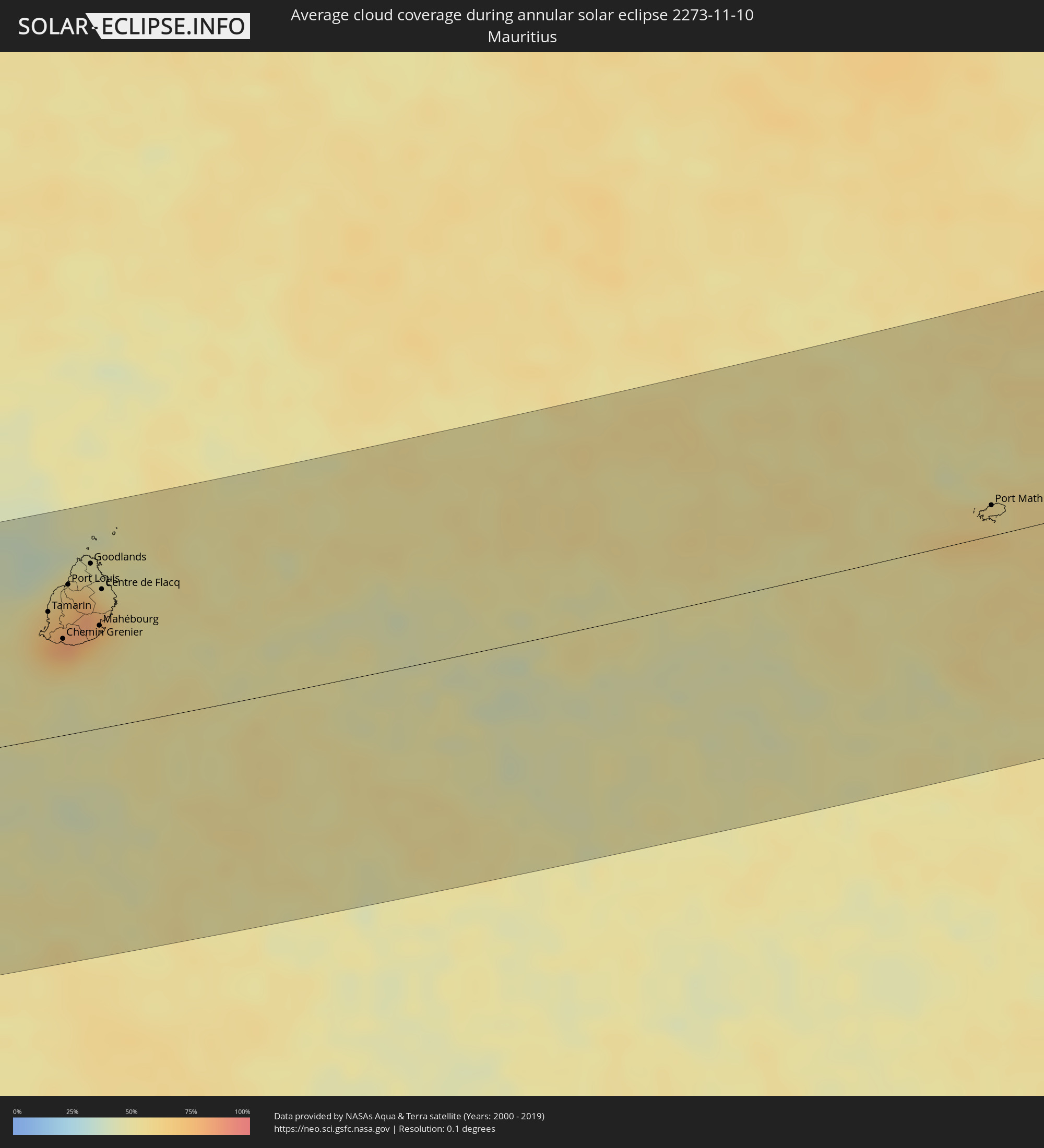 Mauritius
Cities inside the path of the eclipse
The following table shows all locations with a population of more than 5,000 inside the eclipse path. Cities which have more than 100,000 inhabitants are marked bold. A click at the locations opens a detailed map.
| City | Type | Eclipse duration | Local time of max. eclipse | Distance to central line | Ø Cloud coverage |
|
Benguela, Benguela Province
|
annular | - | 10:04:27 UTC+01:00 | 87 km | 57% |
|
Lubango, Huíla
|
annular | - | 10:08:53 UTC+01:00 | 134 km | 55% |
|
Lobito, Benguela Province
|
annular | - | 10:04:25 UTC+01:00 | 114 km | 70% |
|
Catumbela, Benguela Province
|
annular | - | 10:04:34 UTC+01:00 | 108 km | 70% |
|
Caluquembe, Huíla
|
annular | - | 10:10:02 UTC+01:00 | 39 km | 60% |
|
Caconda, Huíla
|
annular | - | 10:11:00 UTC+01:00 | 65 km | 63% |
|
Menongue, Cuando Cobango
|
annular | - | 10:20:15 UTC+01:00 | 112 km | 57% |
|
Nkurenkuru, Kavango West
|
annular | - | 11:28:12 UTC+02:00 | 134 km | 49% |
|
Rundu, Kavango East
|
annular | - | 11:32:21 UTC+02:00 | 109 km | 47% |
|
Shakawe, North-West
|
annular | - | 11:39:42 UTC+02:00 | 58 km | 42% |
|
Katima Mulilo, Zambezi
|
annular | - | 11:46:30 UTC+02:00 | 134 km | 46% |
|
Francistown, North-East
|
annular | - | 12:02:46 UTC+02:00 | 127 km | 47% |
|
Toliara, Atsimo-Andrefana
|
annular | - | 13:56:19 UTC+03:00 | 105 km | 39% |
|
Behompy, Atsimo-Andrefana
|
annular | - | 13:56:50 UTC+03:00 | 94 km | 28% |
|
Ankazoabo, Atsimo-Andrefana
|
annular | - | 13:58:48 UTC+03:00 | 13 km | 27% |
|
Sakaraha, Atsimo-Andrefana
|
annular | - | 13:58:45 UTC+03:00 | 56 km | 23% |
|
Beroroha, Atsimo-Andrefana
|
annular | - | 14:00:40 UTC+03:00 | 80 km | 28% |
|
Ranohira, Ihorombe
|
annular | - | 14:01:10 UTC+03:00 | 12 km | 33% |
|
Ihosy, Ihorombe
|
annular | - | 14:03:06 UTC+03:00 | 6 km | 29% |
|
Ikalamavony, Upper Matsiatra
|
annular | - | 14:04:35 UTC+03:00 | 132 km | 30% |
|
Ambalavao, Upper Matsiatra
|
annular | - | 14:05:21 UTC+03:00 | 54 km | 39% |
|
Fianarantsoa, Upper Matsiatra
|
annular | - | 14:05:50 UTC+03:00 | 95 km | 49% |
|
Fandrandava, Upper Matsiatra
|
annular | - | 14:06:14 UTC+03:00 | 87 km | 53% |
|
Vondrozo, Atsimo-Atsinanana
|
annular | - | 14:05:58 UTC+03:00 | 58 km | 68% |
|
Ikongo, Vatovavy Fitovinany
|
annular | - | 14:06:37 UTC+03:00 | 45 km | 66% |
|
Manato, Atsimo-Atsinanana
|
annular | - | 14:06:35 UTC+03:00 | 13 km | 69% |
|
Vohipaho, Atsimo-Atsinanana
|
annular | - | 14:06:16 UTC+03:00 | 141 km | 65% |
|
Vangaindrano, Atsimo-Atsinanana
|
annular | - | 14:06:35 UTC+03:00 | 119 km | 63% |
|
Ifanadiana, Vatovavy Fitovinany
|
annular | - | 14:07:17 UTC+03:00 | 108 km | 64% |
|
Vohimanitra, Vatovavy Fitovinany
|
annular | - | 14:07:20 UTC+03:00 | 63 km | 67% |
|
Ifatsy, Vatovavy Fitovinany
|
annular | - | 14:07:15 UTC+03:00 | 15 km | 61% |
|
Farafangana, Atsimo-Atsinanana
|
annular | - | 14:07:18 UTC+03:00 | 62 km | 55% |
|
Amboanjo, Vatovavy Fitovinany
|
annular | - | 14:07:37 UTC+03:00 | 29 km | 64% |
|
Manakara, Vatovavy Fitovinany
|
annular | - | 14:07:59 UTC+03:00 | 11 km | 55% |
|
Mananjary, Vatovavy Fitovinany
|
annular | - | 14:09:05 UTC+03:00 | 111 km | 55% |
|
Saint-Paul, Réunion
|
annular | - | 15:24:17 UTC+04:00 | 46 km | 79% |
|
Saint-Leu, Réunion
|
annular | - | 15:24:14 UTC+04:00 | 28 km | 66% |
|
Le Port, Réunion
|
annular | - | 15:24:22 UTC+04:00 | 54 km | 73% |
|
Trois-Bassins, Réunion
|
annular | - | 15:24:17 UTC+04:00 | 36 km | 78% |
|
Piton Saint-Leu, Réunion
|
annular | - | 15:24:15 UTC+04:00 | 22 km | 66% |
|
La Possession, Réunion
|
annular | - | 15:24:27 UTC+04:00 | 54 km | 73% |
|
Les Avirons, Réunion
|
annular | - | 15:24:17 UTC+04:00 | 19 km | 66% |
|
Saint-Louis, Réunion
|
annular | - | 15:24:24 UTC+04:00 | 13 km | 58% |
|
Saint-Denis, Réunion
|
annular | - | 15:24:41 UTC+04:00 | 57 km | 76% |
|
L'Entre-Deux, Réunion
|
annular | - | 15:24:32 UTC+04:00 | 18 km | 77% |
|
Cilaos, Réunion
|
annular | - | 15:24:35 UTC+04:00 | 29 km | 77% |
|
Saint-Pierre, Réunion
|
annular | - | 15:24:29 UTC+04:00 | 6 km | 65% |
|
Le Tampon, Réunion
|
annular | - | 15:24:36 UTC+04:00 | 12 km | 65% |
|
Salazie, Réunion
|
annular | - | 15:24:46 UTC+04:00 | 40 km | 81% |
|
Sainte-Marie, Réunion
|
annular | - | 15:24:52 UTC+04:00 | 54 km | 76% |
|
Petite-Île, Réunion
|
annular | - | 15:24:39 UTC+04:00 | 4 km | 54% |
|
Sainte-Suzanne, Réunion
|
annular | - | 15:24:58 UTC+04:00 | 52 km | 69% |
|
Saint-Joseph, Réunion
|
annular | - | 15:24:44 UTC+04:00 | 0 km | 54% |
|
Saint-André, Réunion
|
annular | - | 15:25:01 UTC+04:00 | 45 km | 71% |
|
Bras-Panon, Réunion
|
annular | - | 15:25:03 UTC+04:00 | 40 km | 71% |
|
Saint-Benoît, Réunion
|
annular | - | 15:25:06 UTC+04:00 | 35 km | 71% |
|
Saint-Philippe, Réunion
|
annular | - | 15:25:01 UTC+04:00 | 1 km | 54% |
|
Sainte-Rose, Réunion
|
annular | - | 15:25:11 UTC+04:00 | 24 km | 68% |
|
Chemin Grenier, Savanne
|
annular | - | 15:28:30 UTC+04:00 | 63 km | 65% |
|
Vacoas, Plaines Wilhems
|
annular | - | 15:28:38 UTC+04:00 | 84 km | 81% |
|
Moka, Moka
|
annular | - | 15:28:43 UTC+04:00 | 92 km | 75% |
|
Port Louis, Port Louis
|
annular | - | 15:28:45 UTC+04:00 | 98 km | 75% |
|
Grande Pointe aux Piments, Pamplemousses
|
annular | - | 15:28:50 UTC+04:00 | 109 km | 70% |
|
Terre Rouge, Pamplemousses
|
annular | - | 15:28:49 UTC+04:00 | 102 km | 70% |
|
Grand Bois, Savanne
|
annular | - | 15:28:41 UTC+04:00 | 69 km | 81% |
|
Rivière des Anguilles, Savanne
|
annular | - | 15:28:39 UTC+04:00 | 62 km | 58% |
|
Morcellemont Saint André, Pamplemousses
|
annular | - | 15:28:54 UTC+04:00 | 107 km | 75% |
|
Nouvelle France, Grand Port
|
annular | - | 15:28:44 UTC+04:00 | 74 km | 72% |
|
Dagotière, Moka
|
annular | - | 15:28:49 UTC+04:00 | 88 km | 82% |
|
Long Mountain, Pamplemousses
|
annular | - | 15:28:52 UTC+04:00 | 99 km | 75% |
|
Pamplemousses, Pamplemousses
|
annular | - | 15:28:54 UTC+04:00 | 103 km | 75% |
|
Plaine des Papayes, Pamplemousses
|
annular | - | 15:28:56 UTC+04:00 | 107 km | 75% |
|
Fond du Sac, Pamplemousses
|
annular | - | 15:28:57 UTC+04:00 | 110 km | 62% |
|
Quartier Militaire, Moka
|
annular | - | 15:28:52 UTC+04:00 | 87 km | 82% |
|
Petit Raffray, Rivière du Rempart
|
annular | - | 15:29:02 UTC+04:00 | 112 km | 62% |
|
New Grove, Grand Port
|
annular | - | 15:28:48 UTC+04:00 | 69 km | 72% |
|
Piton, Rivière du Rempart
|
annular | - | 15:29:01 UTC+04:00 | 103 km | 75% |
|
Goodlands, Rivière du Rempart
|
annular | - | 15:29:04 UTC+04:00 | 109 km | 62% |
|
Brisée Verdière, Flacq
|
annular | - | 15:29:00 UTC+04:00 | 95 km | 82% |
|
Bon Accueil, Flacq
|
annular | - | 15:29:01 UTC+04:00 | 94 km | 77% |
|
Montagne Blanche
|
annular | - | 15:28:57 UTC+04:00 | 82 km | 72% |
|
Grand Gaube, Rivière du Rempart
|
annular | - | 15:29:07 UTC+04:00 | 112 km | 53% |
|
Lalmatie, Flacq
|
annular | - | 15:29:01 UTC+04:00 | 92 km | 77% |
|
Laventure, Flacq
|
annular | - | 15:29:04 UTC+04:00 | 96 km | 64% |
|
Sebastopol, Flacq
|
annular | - | 15:29:00 UTC+04:00 | 80 km | 72% |
|
Beau Vallon, Grand Port
|
annular | - | 15:28:56 UTC+04:00 | 66 km | 61% |
|
Mahébourg, Grand Port
|
annular | - | 15:28:57 UTC+04:00 | 67 km | 61% |
|
Roches Noire, Rivière du Rempart
|
annular | - | 15:29:09 UTC+04:00 | 100 km | 64% |
|
Centre de Flacq, Flacq
|
annular | - | 15:29:06 UTC+04:00 | 91 km | 77% |
|
Poste de Flacq, Flacq
|
annular | - | 15:29:09 UTC+04:00 | 94 km | 77% |
|
Ecroignard, Flacq
|
annular | - | 15:29:07 UTC+04:00 | 87 km | 77% |
|
Port Mathurin, Rodrigues
|
annular | - | 15:37:47 UTC+04:00 | 20 km | 62% |