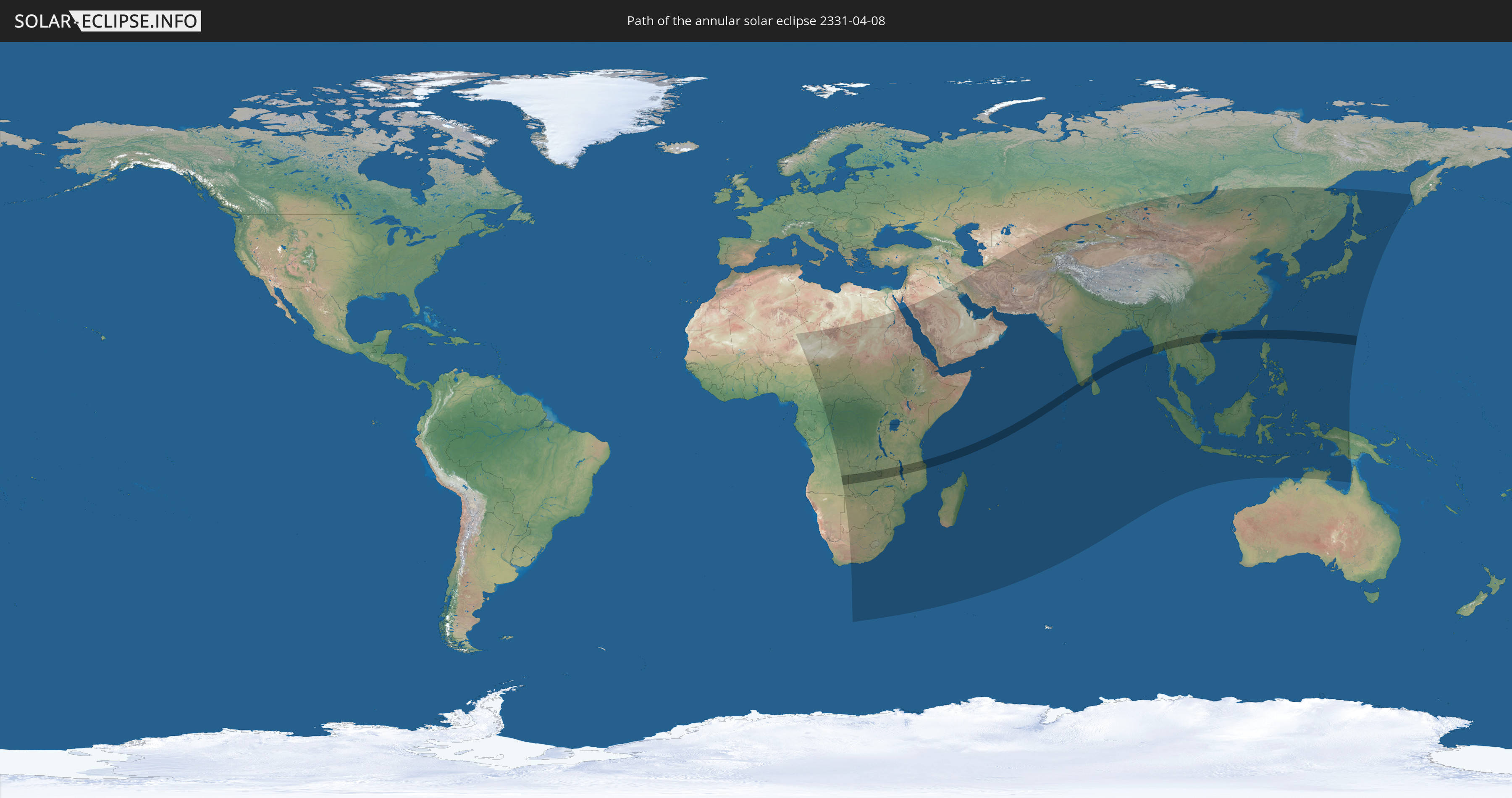
Annular solar eclipse of 04/08/2331
| Day of week: | Wednesday |
| Maximum duration of eclipse: | 06m07s |
| Maximum width of eclipse path: | 181 km |
| Saros cycle: | 144 |
| Coverage: | 95.1% |
| Magnitude: | 0.9506 |
| Gamma: | 0.0408 |
Wo kann man die Sonnenfinsternis vom 04/08/2331 sehen?
Die Sonnenfinsternis am 04/08/2331 kann man in 85 Ländern als partielle Sonnenfinsternis beobachten.
Der Finsternispfad verläuft durch 17 Länder. Nur in diesen Ländern ist sie als annular Sonnenfinsternis zu sehen.
In den folgenden Ländern ist die Sonnenfinsternis annular zu sehen
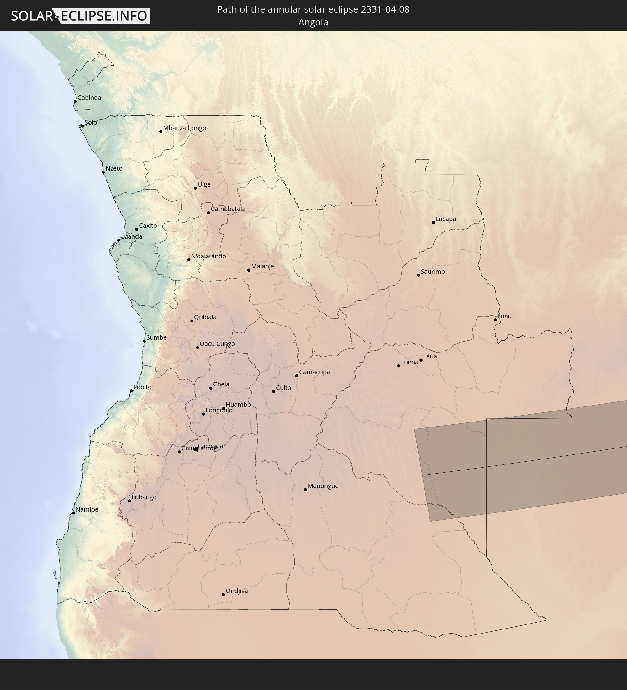 Angola
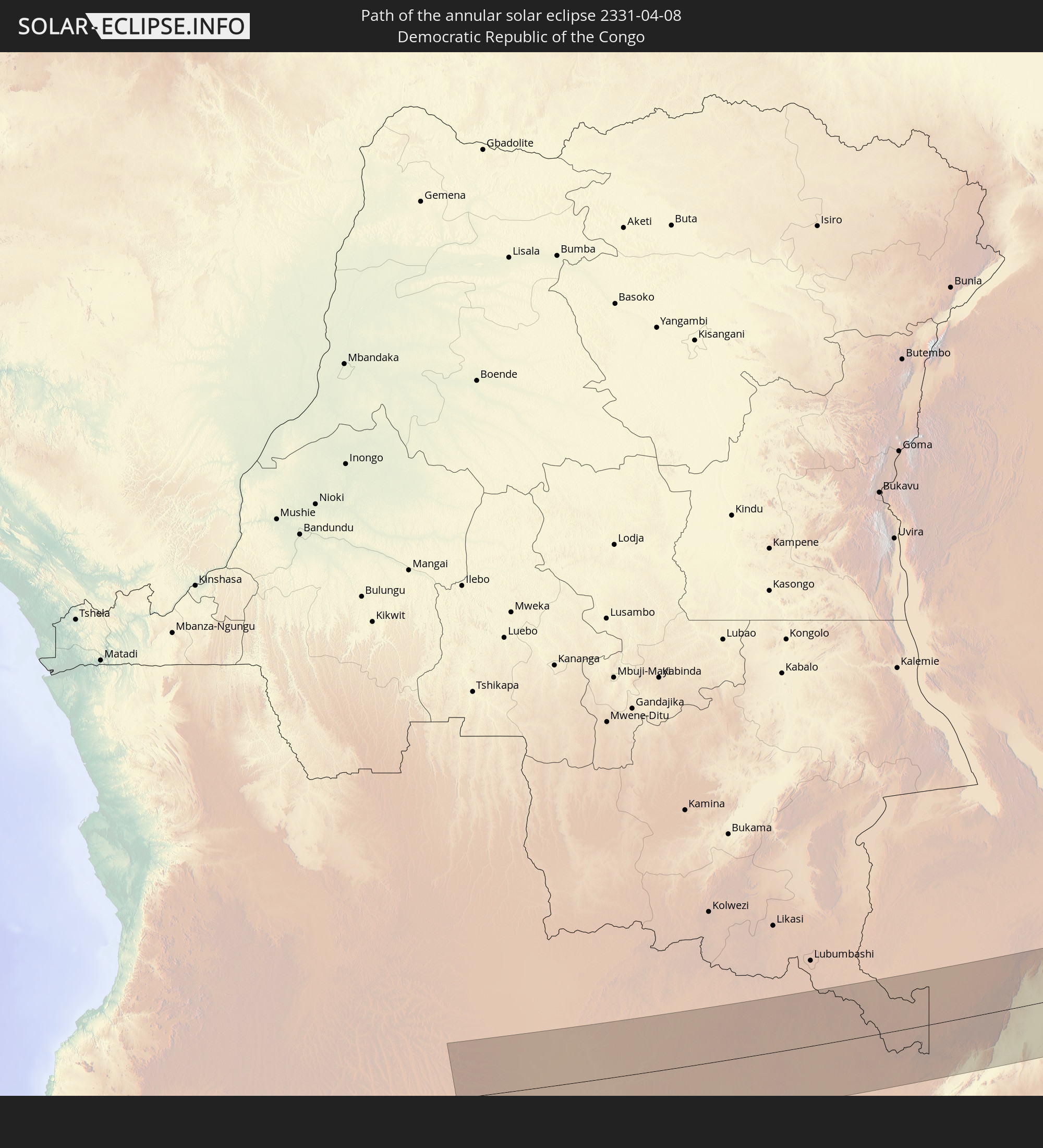 Democratic Republic of the Congo
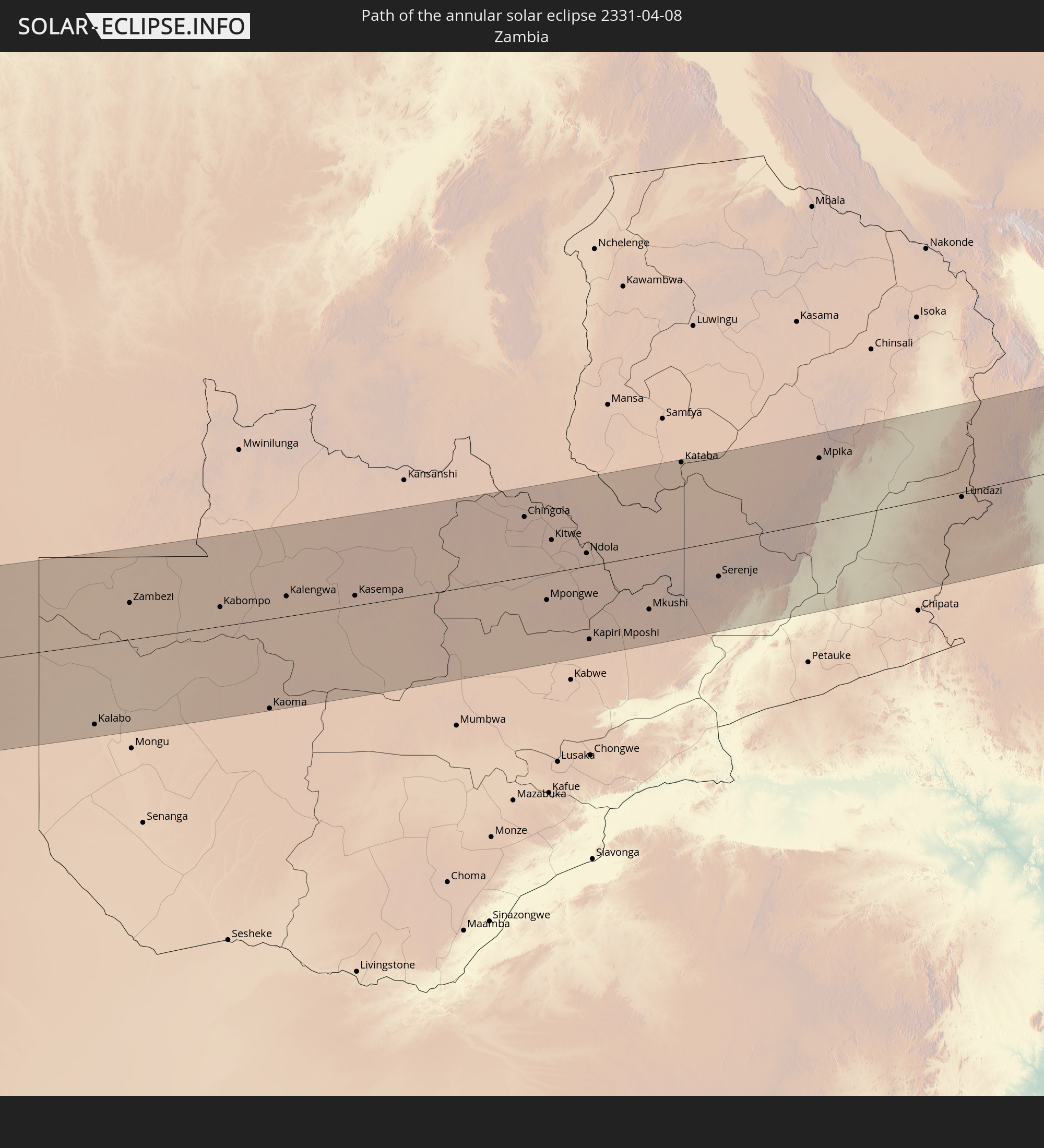 Zambia
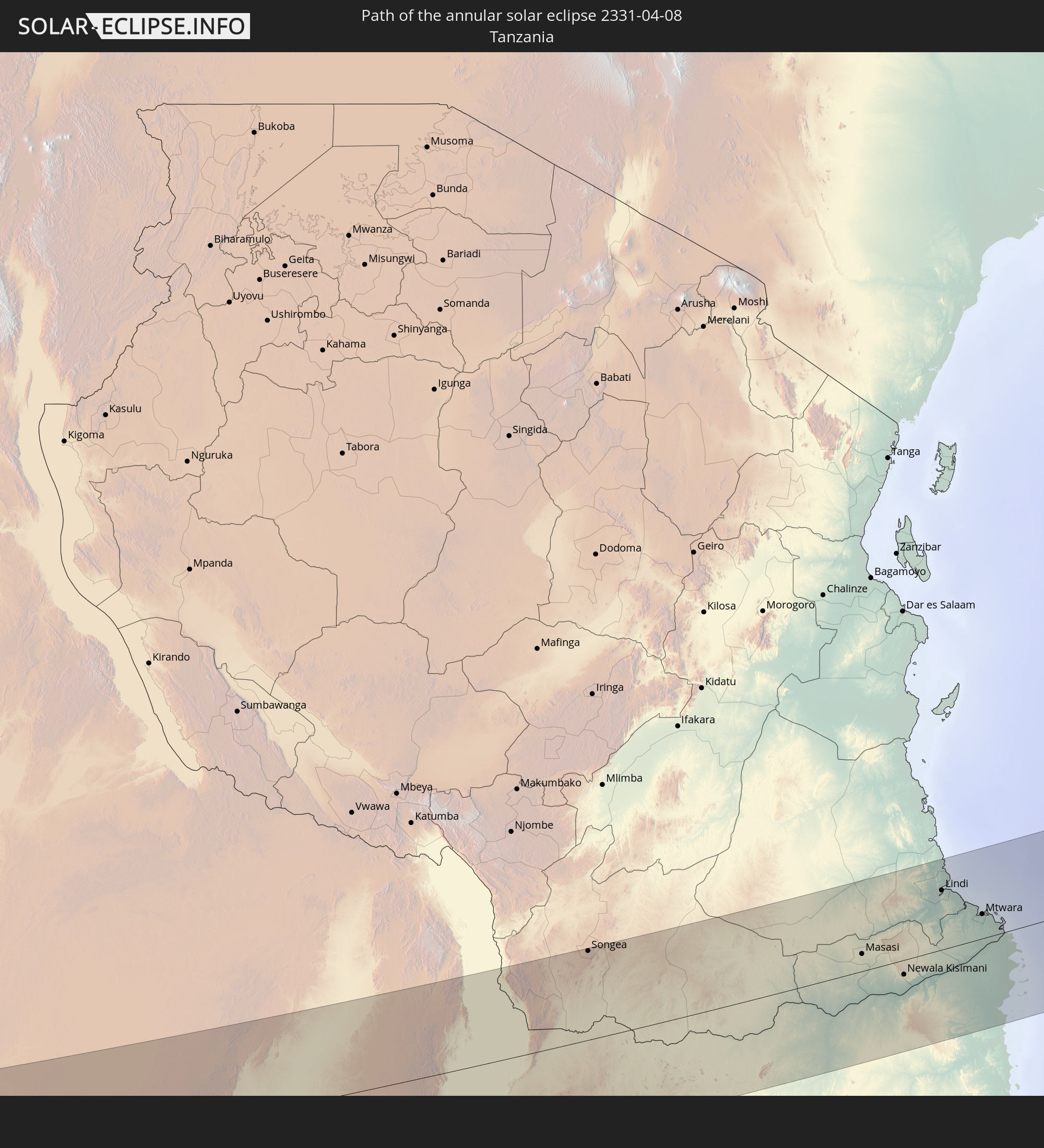 Tanzania
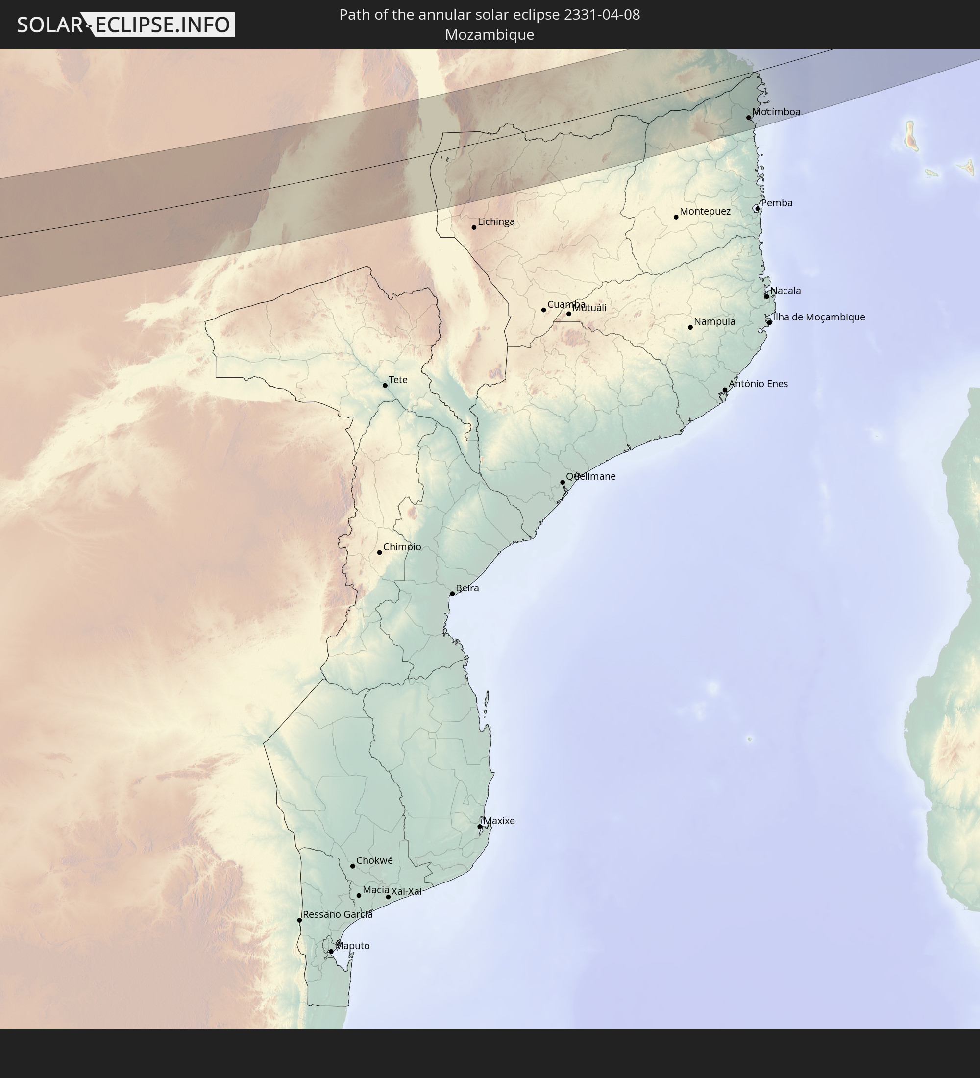 Mozambique
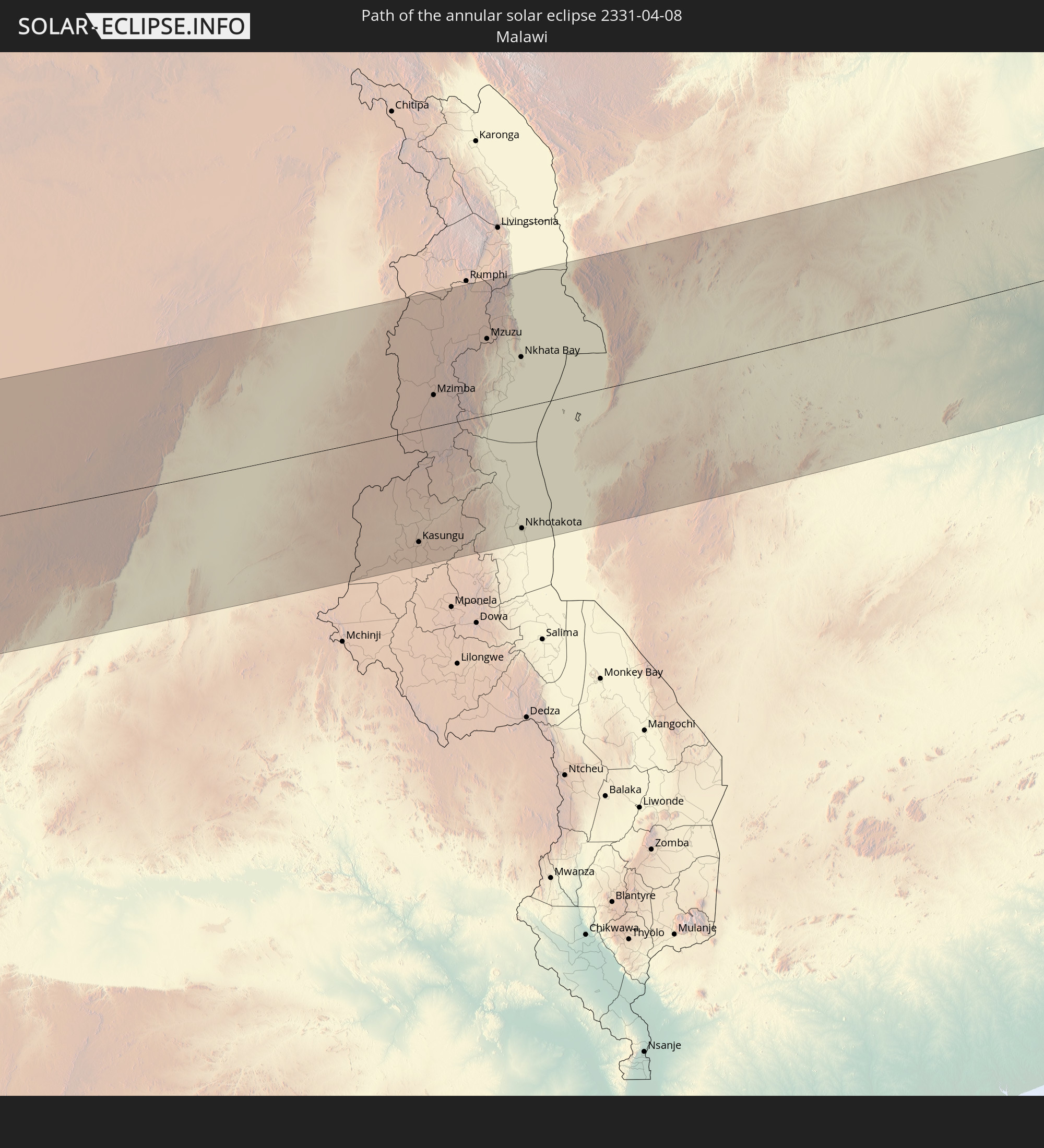 Malawi
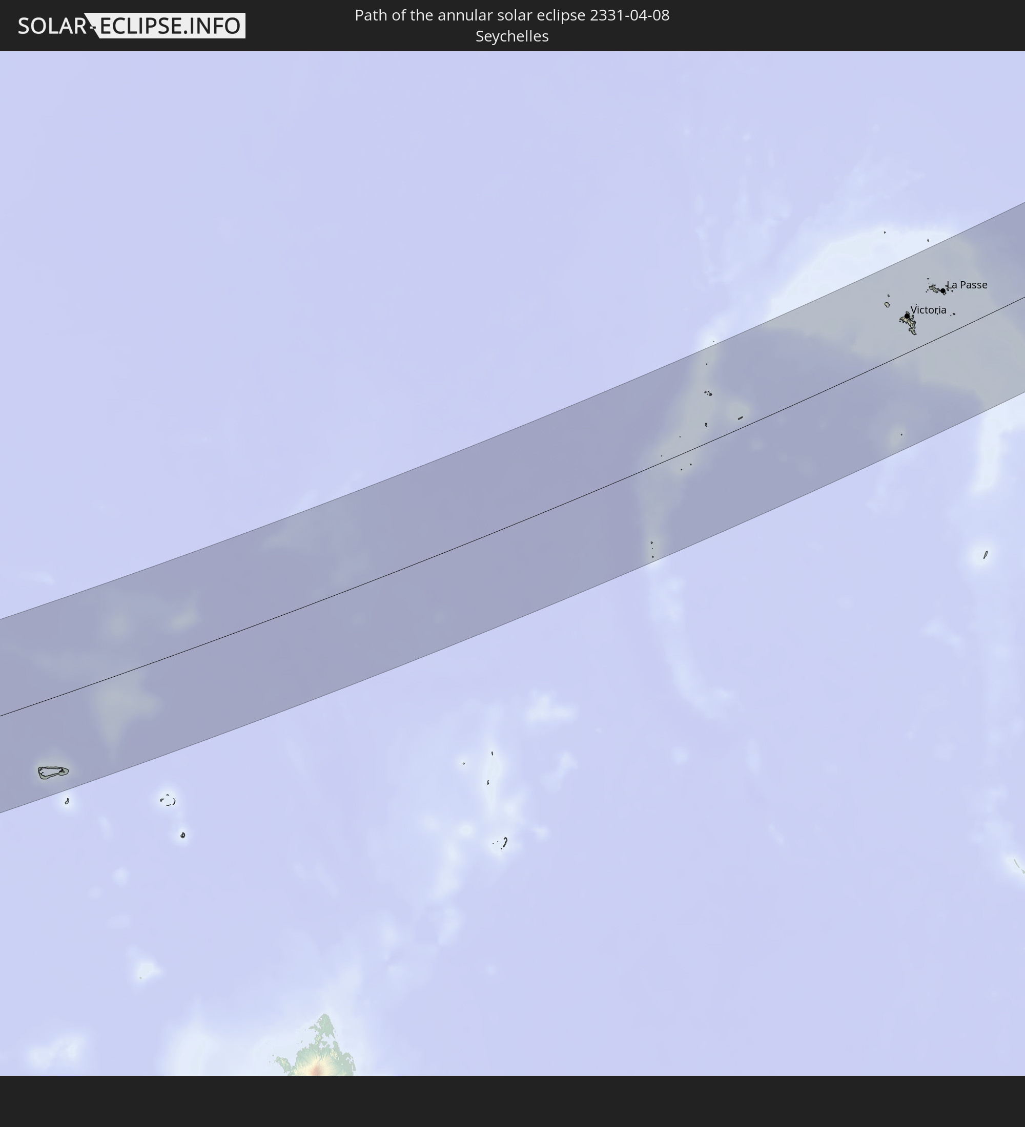 Seychelles
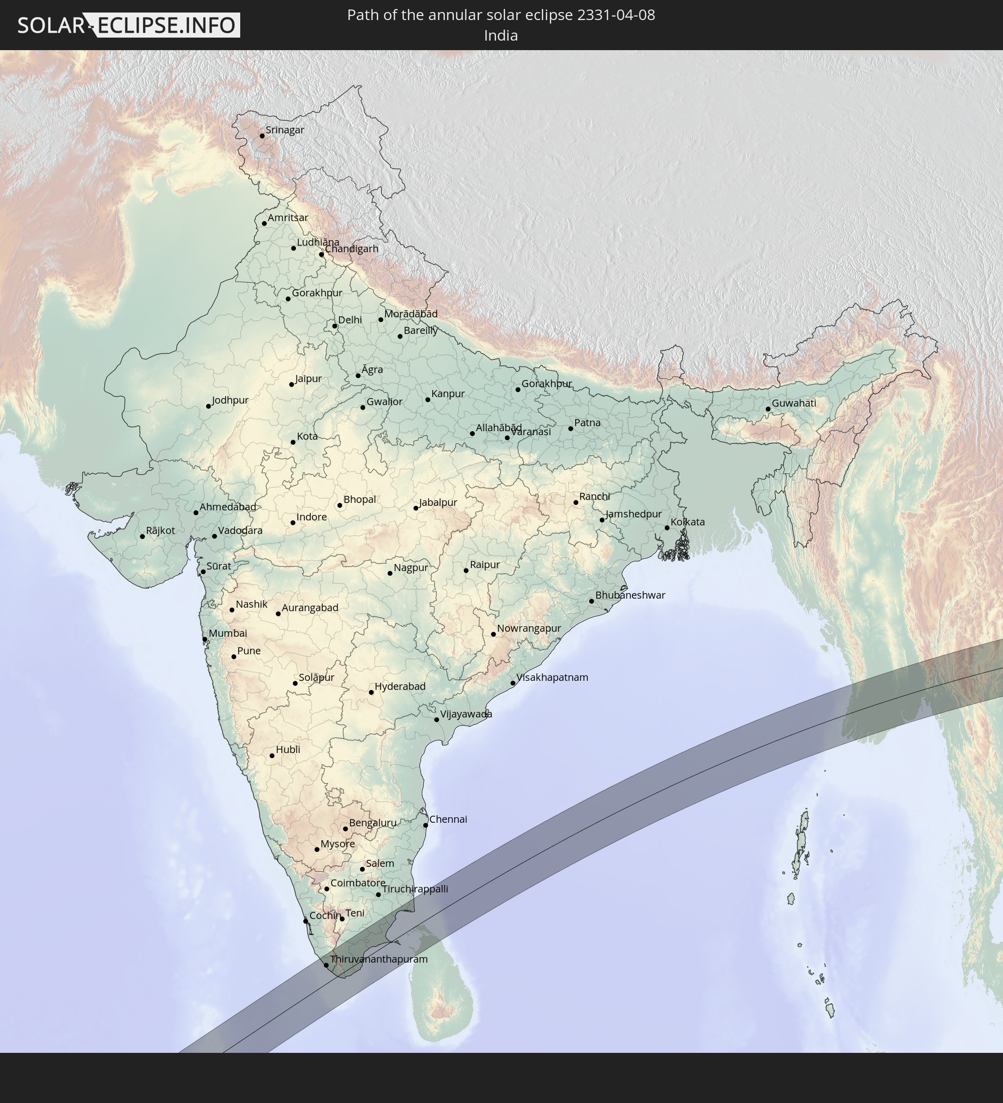 India
India
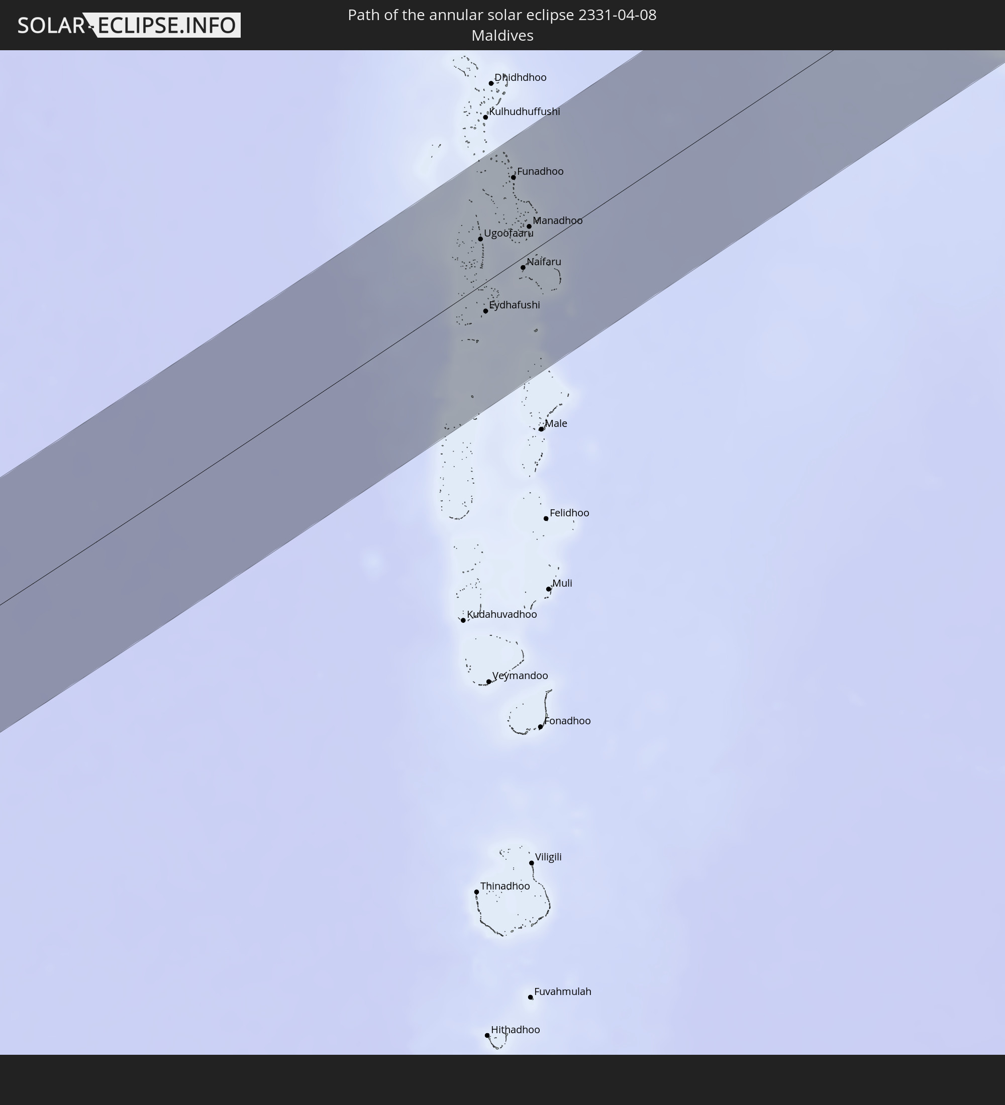 Maldives
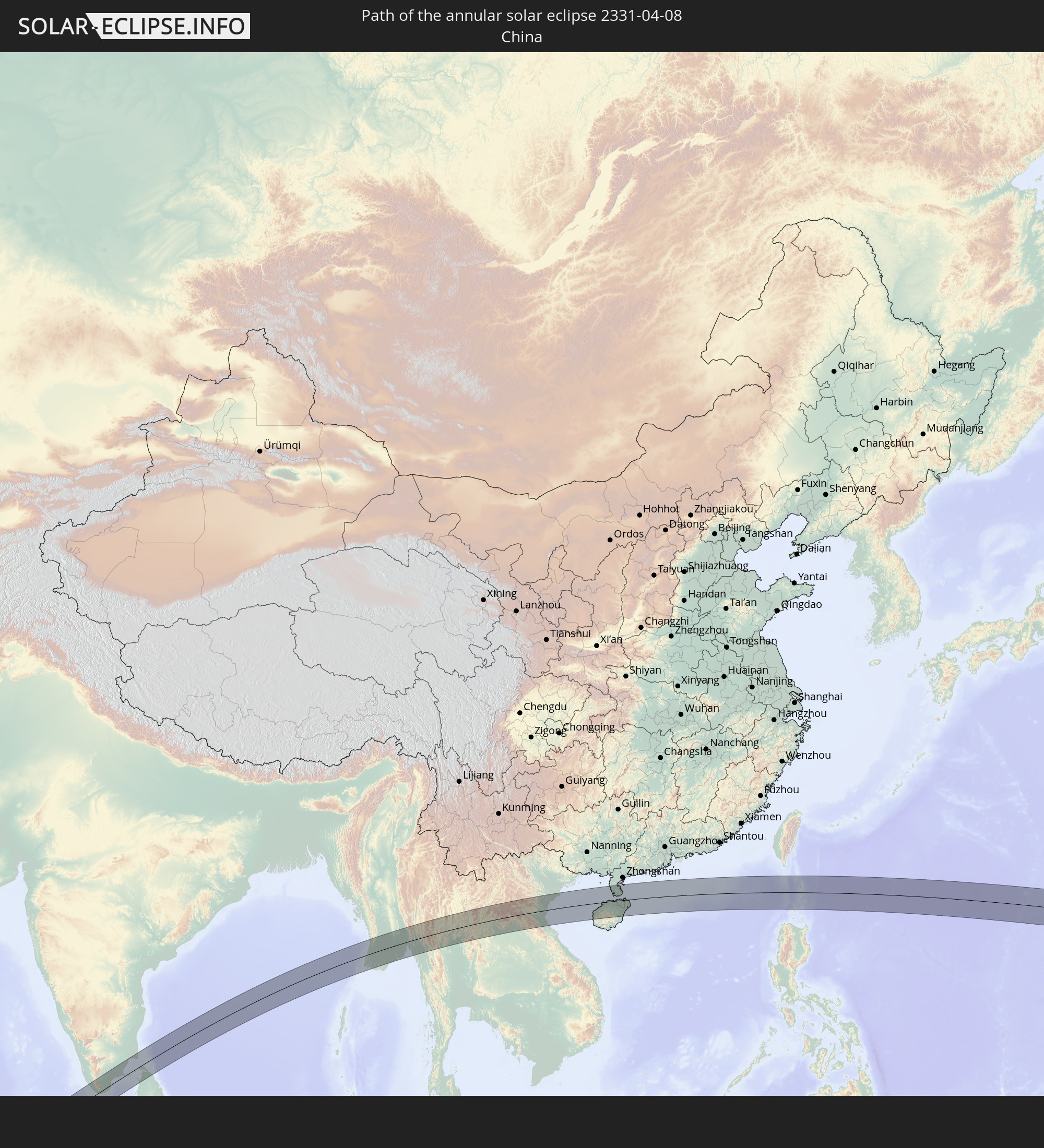 China
China
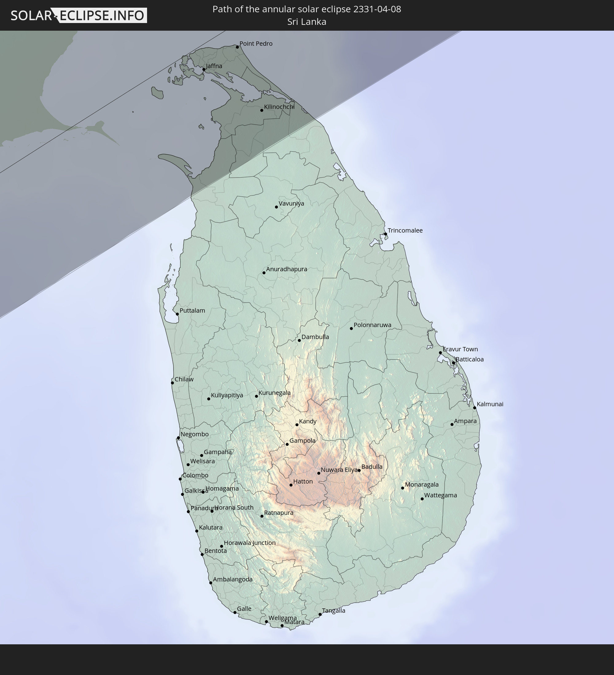 Sri Lanka
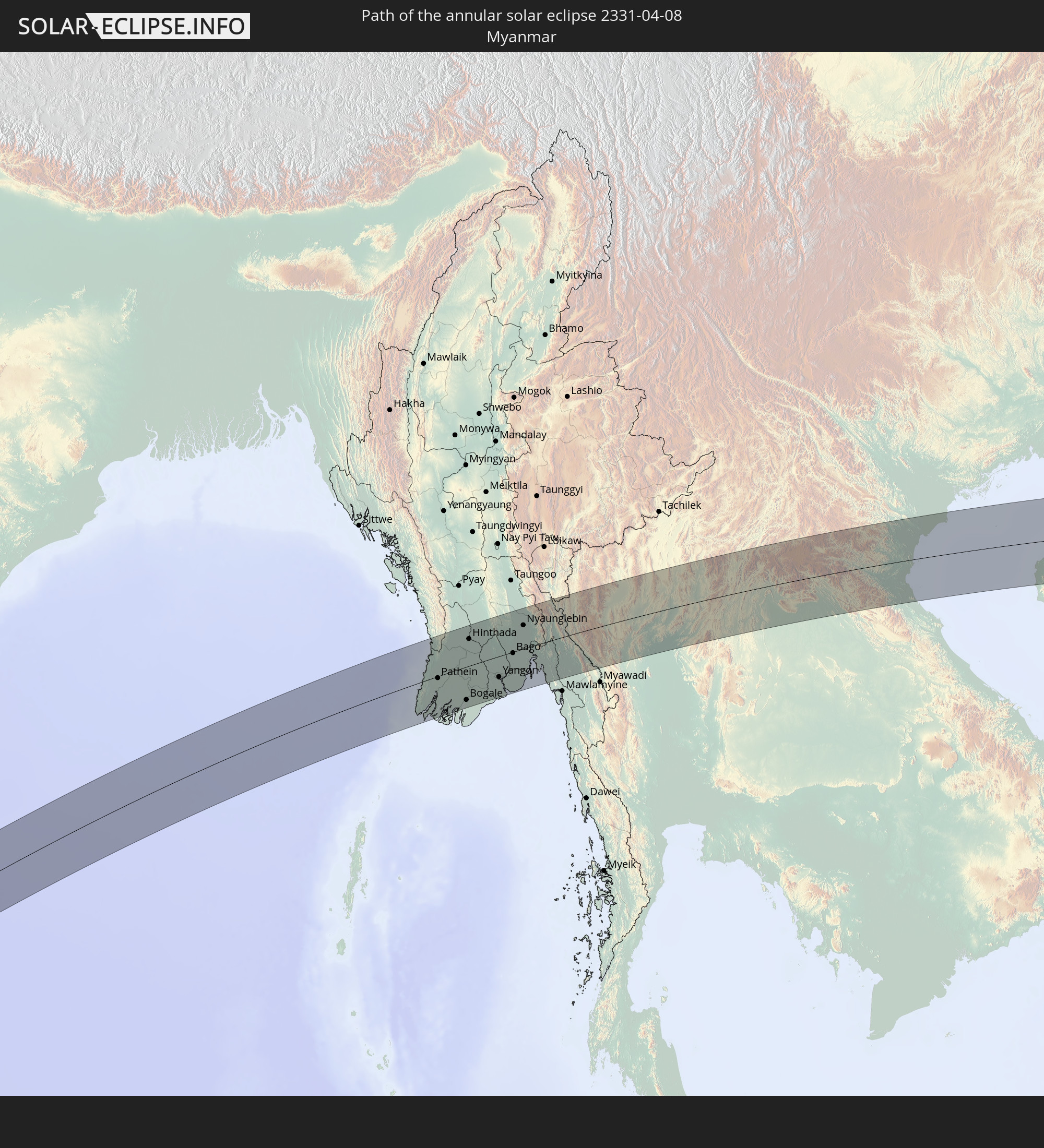 Myanmar
 Thailand
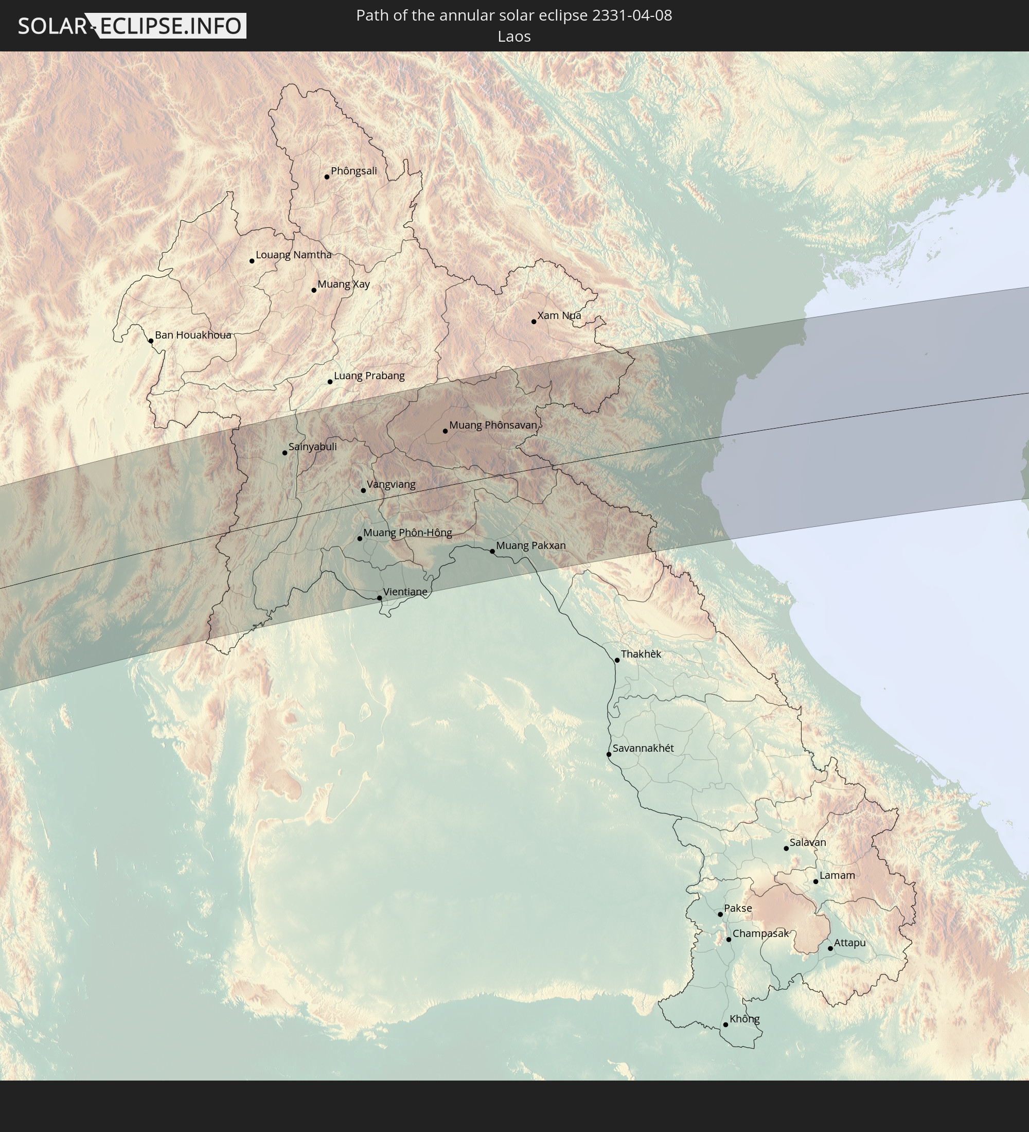 Laos
Laos
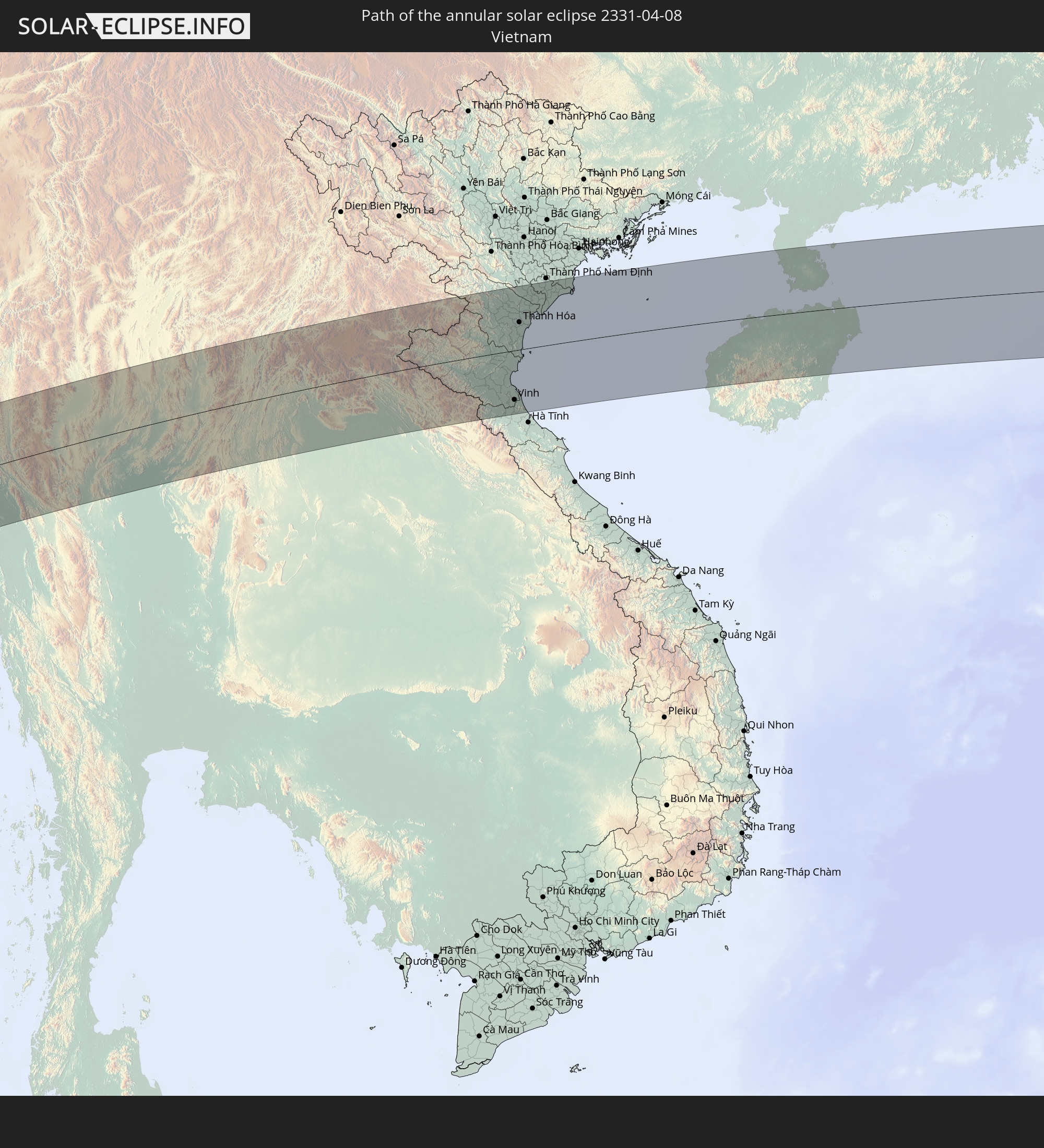 Vietnam
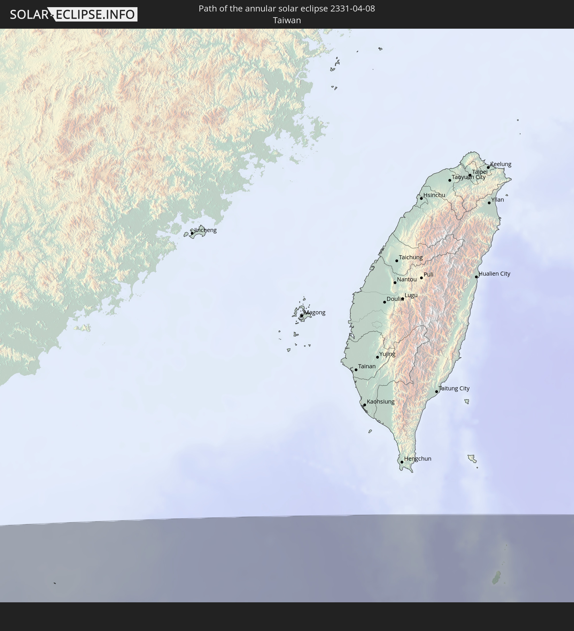 Taiwan
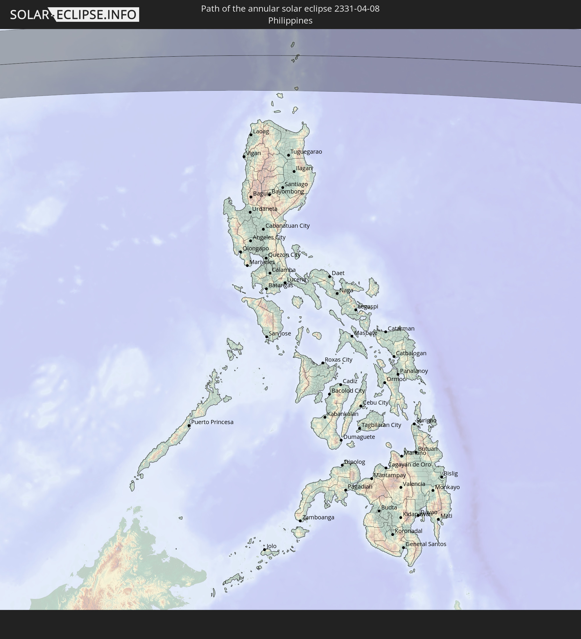 Philippines
In den folgenden Ländern ist die Sonnenfinsternis partiell zu sehen
 Russia
 Niger
Niger
 Nigeria
 Cameroon
 Libya
Libya
 Republic of the Congo
 Angola
 Namibia
 Democratic Republic of the Congo
 Chad
Chad
 Central African Republic
 South Africa
 Botswana
 Sudan
Sudan
 Zambia
 Egypt
Egypt
 Zimbabwe
 Lesotho
 Rwanda
 Burundi
 Tanzania
 Uganda
 Mozambique
 Swaziland
 Malawi
 Ethiopia
 Kenya
Kenya
 Saudi Arabia
 Eritrea
 Iraq
Iraq
 French Southern and Antarctic Lands
 Somalia
 Djibouti
 Yemen
Yemen
 Madagascar
 Comoros
 Iran
Iran
 Mayotte
 Seychelles
 Kazakhstan
 Kuwait
 Bahrain
 Qatar
Qatar
 United Arab Emirates
 Oman
Oman
 Turkmenistan
 Réunion
 Uzbekistan
 Mauritius
 Afghanistan
 Pakistan
 Tajikistan
 India
India
 Kyrgyzstan
 British Indian Ocean Territory
 Maldives
 China
China
 Sri Lanka
 Nepal
Nepal
 Mongolia
 Bangladesh
 Bhutan
 Myanmar
 Indonesia
 Cocos Islands
 Thailand
 Malaysia
 Laos
Laos
 Vietnam
 Cambodia
 Singapore
 Christmas Island
 Australia
 Macau
Macau
 Hong Kong
 Brunei
 Taiwan
 Philippines
 Japan
Japan
 East Timor
 North Korea
 South Korea
 Palau
Palau
 Federated States of Micronesia
 Papua New Guinea
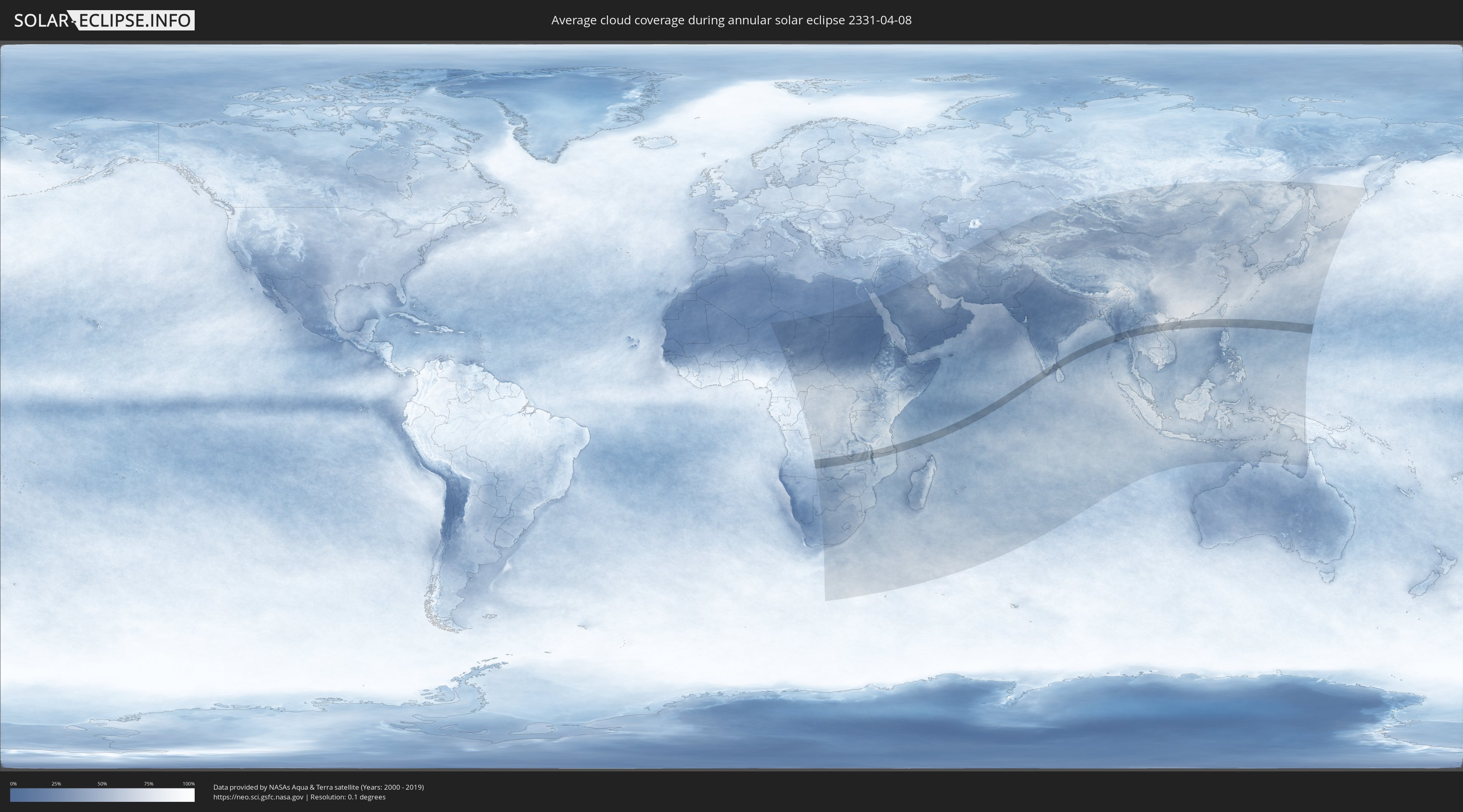
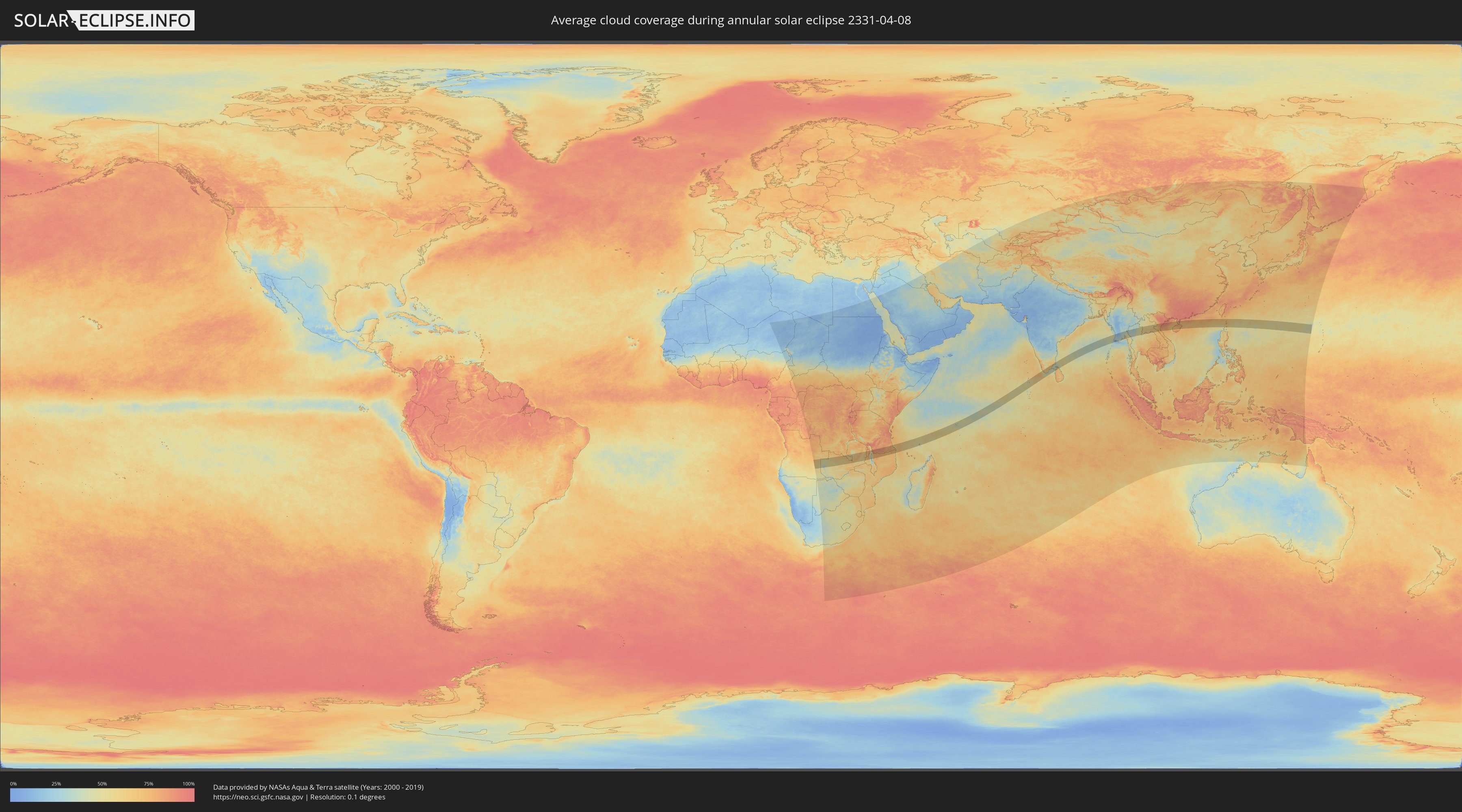
How will be the weather during the annular solar eclipse on 04/08/2331?
Where is the best place to see the annular solar eclipse of 04/08/2331?
The following maps show the average cloud coverage for the day of the annular solar eclipse.
With the help of these maps, it is possible to find the place along the eclipse path, which has the best
chance of a cloudless sky.
Nevertheless, you should consider local circumstances and inform about the weather of your chosen
observation site.
The data is provided by NASAs satellites
AQUA and TERRA.
The cloud maps are averaged over a period of 19 years (2000 - 2019).
Detailed country maps
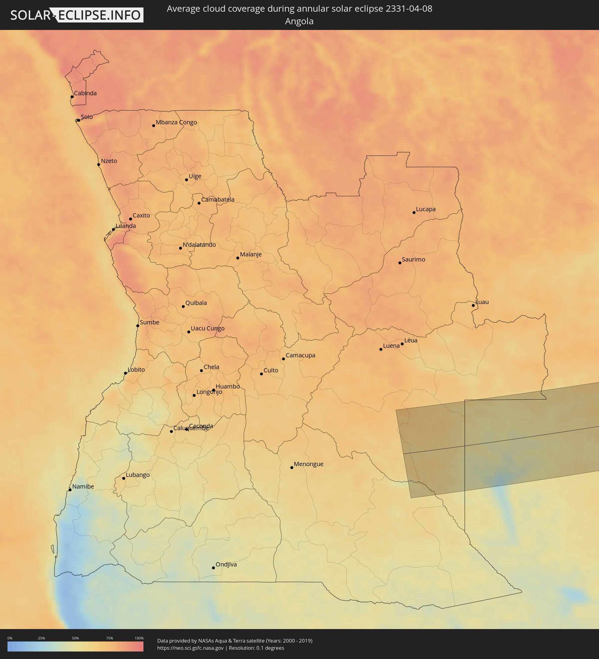 Angola
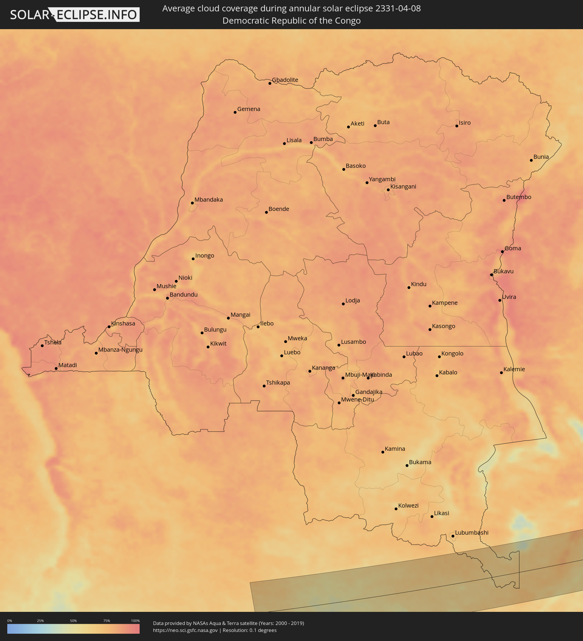 Democratic Republic of the Congo
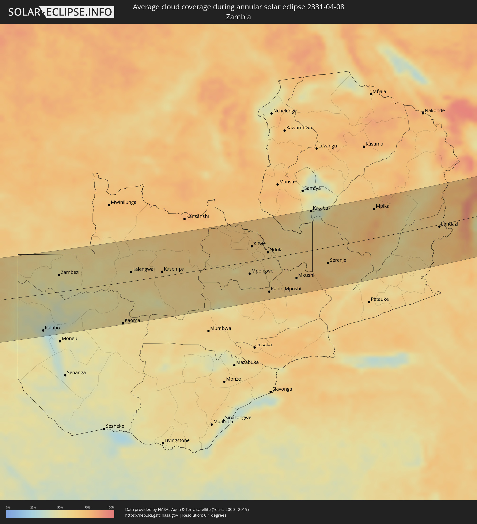 Zambia
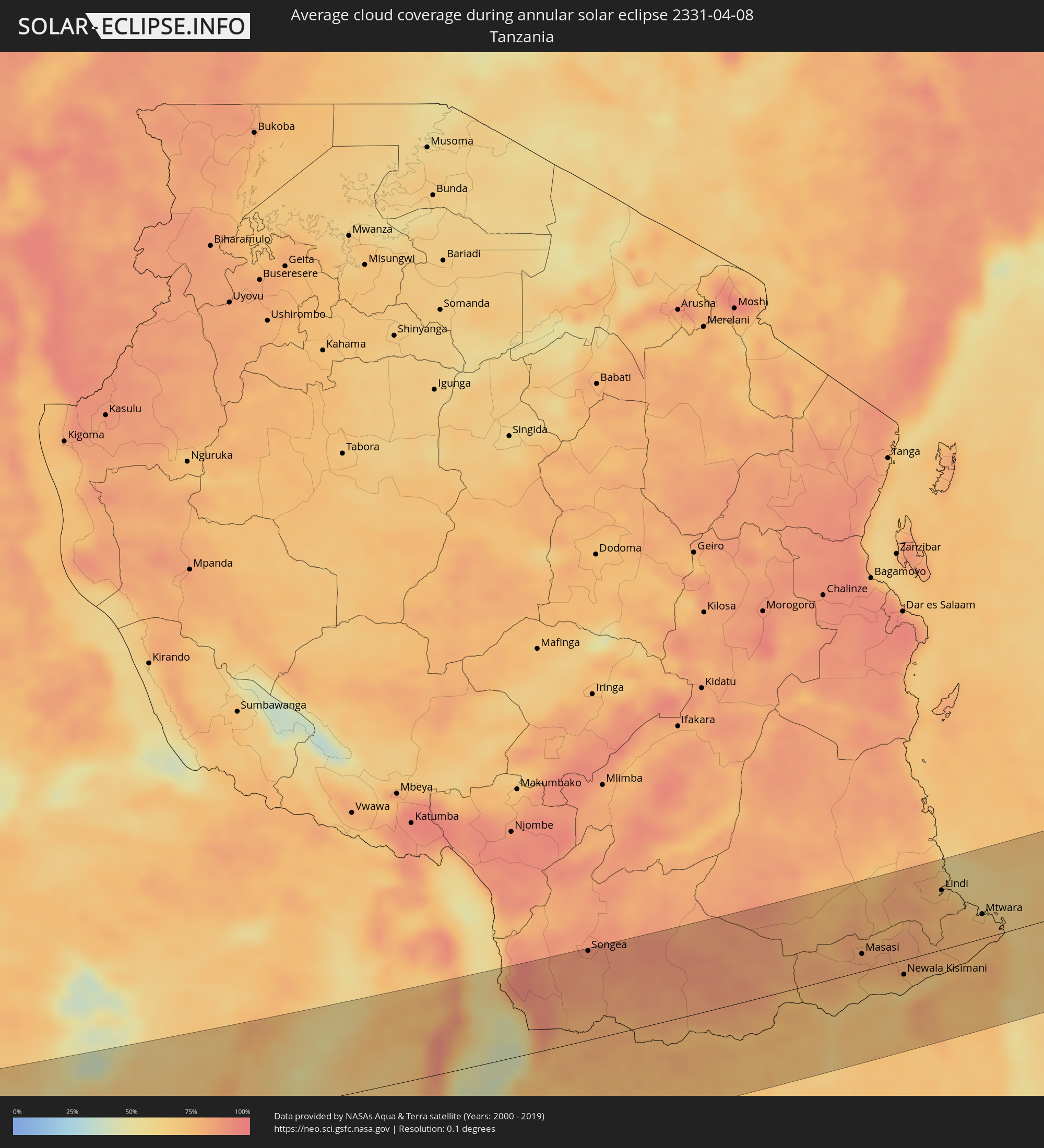 Tanzania
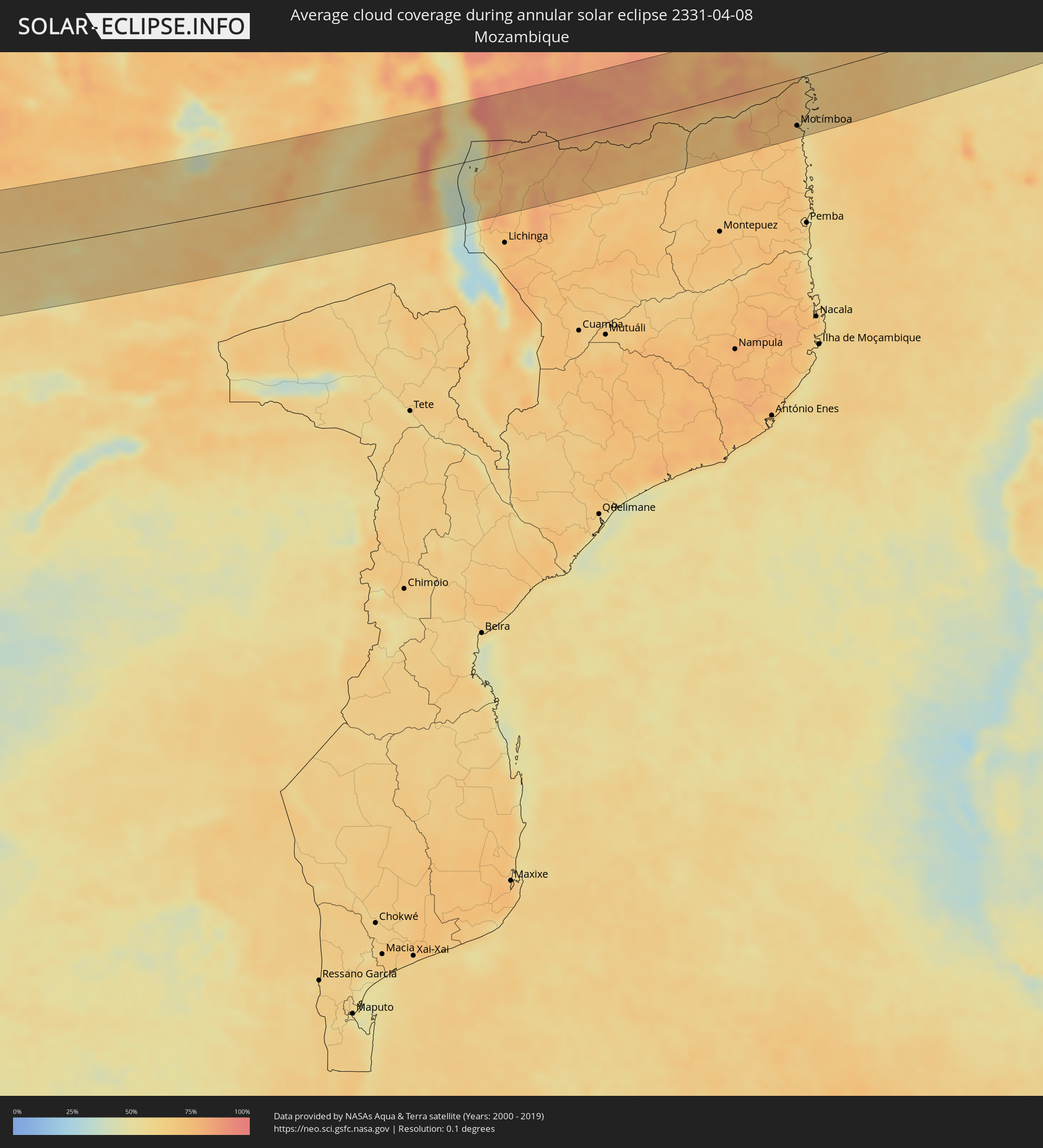 Mozambique
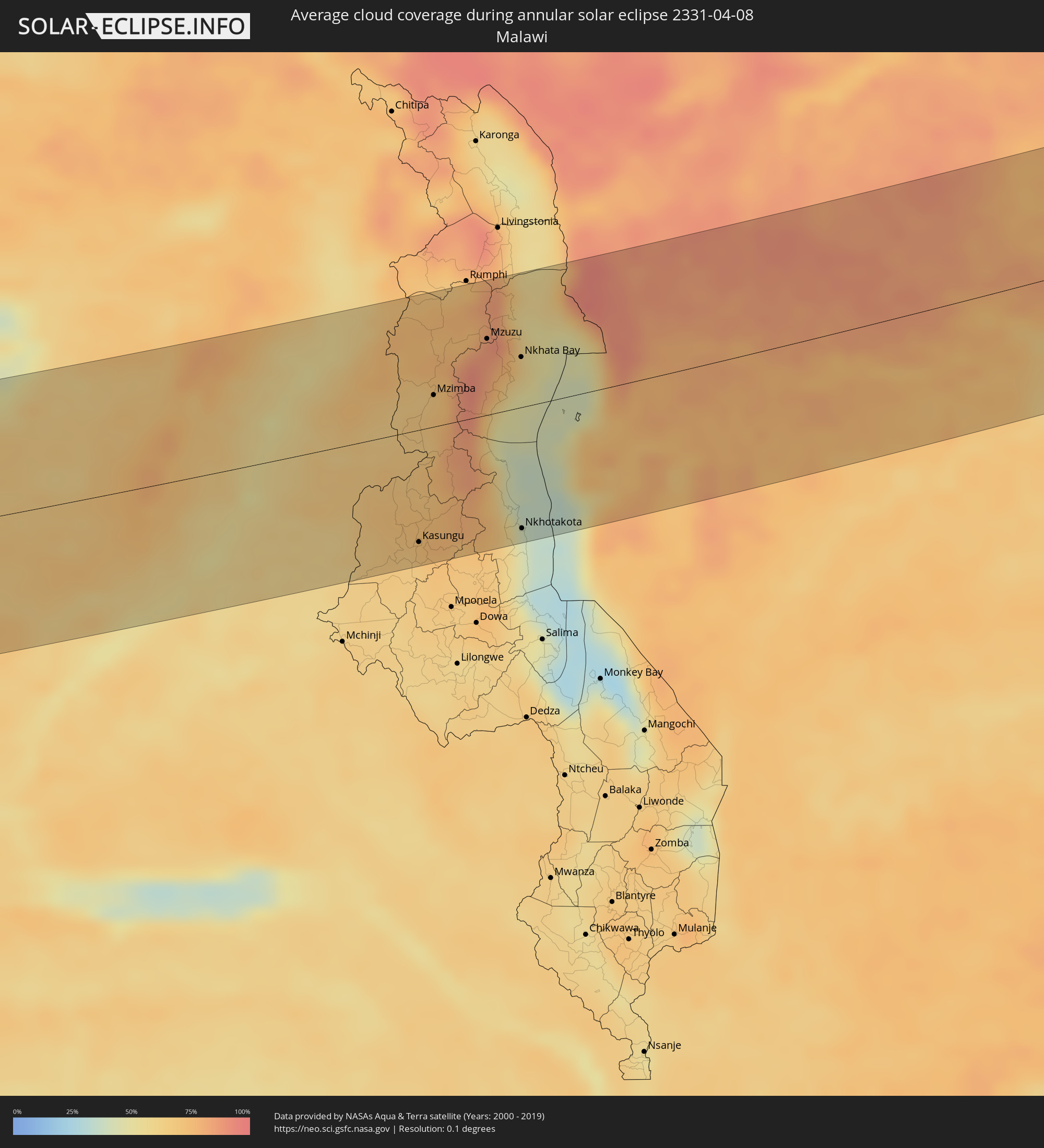 Malawi
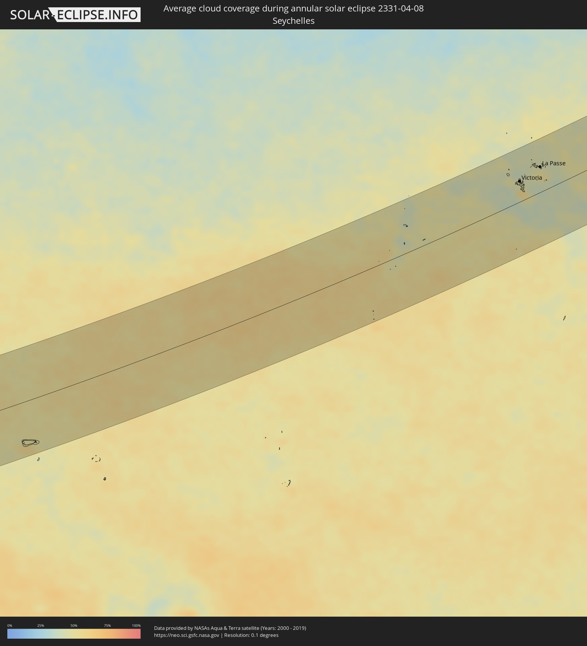 Seychelles
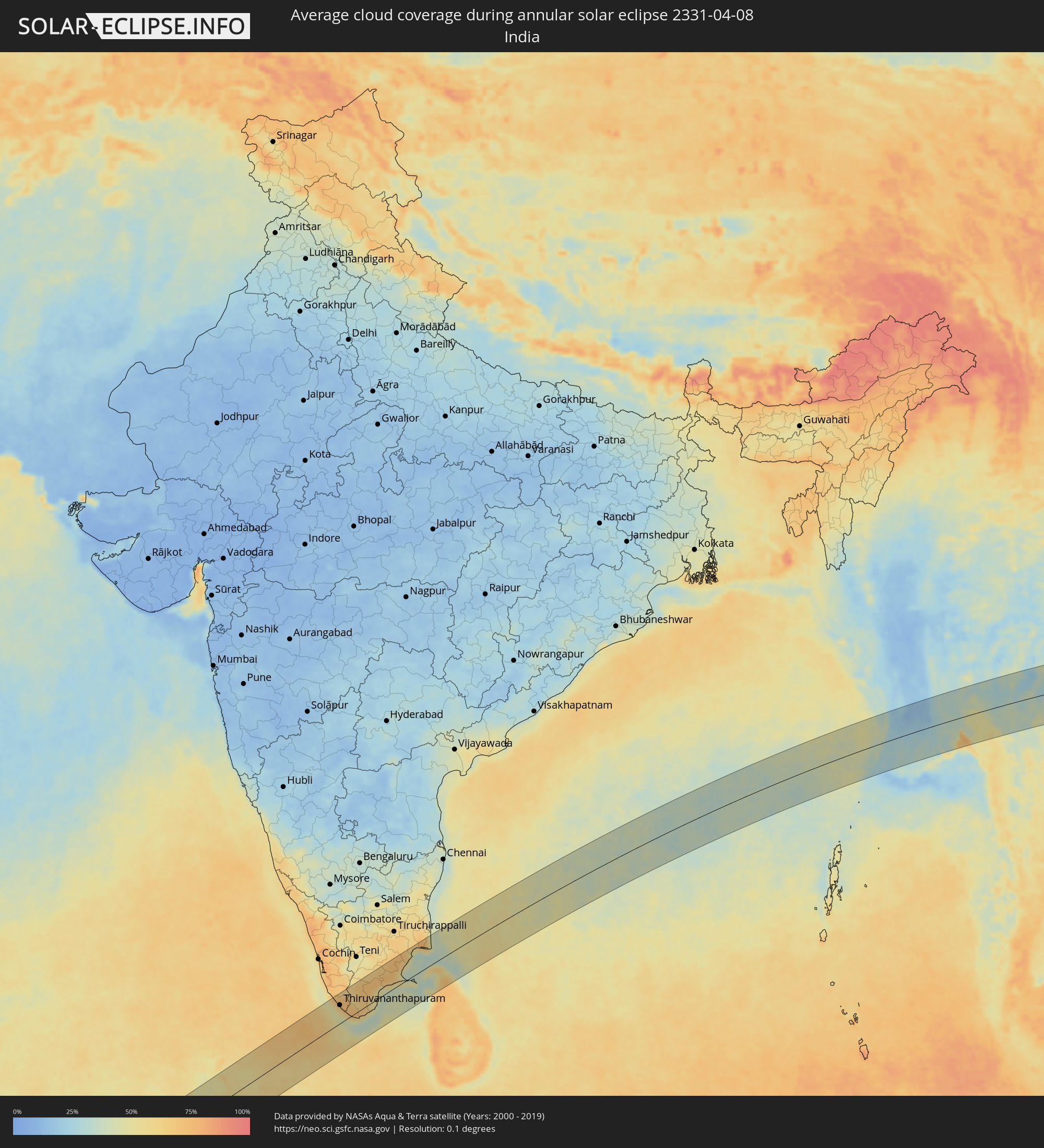 India
India
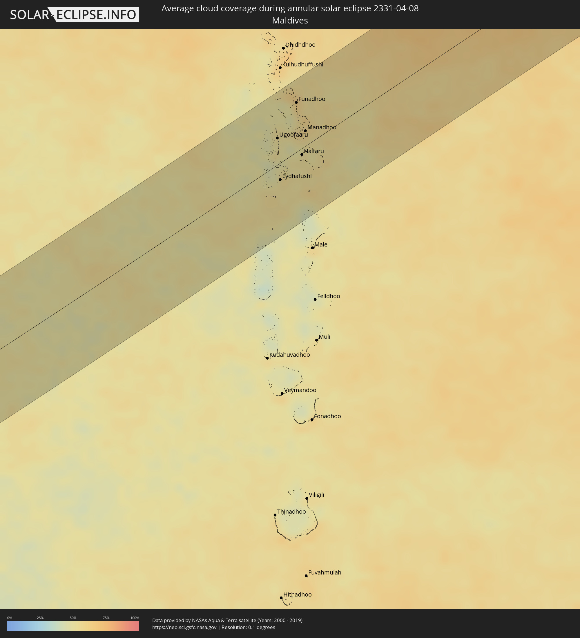 Maldives
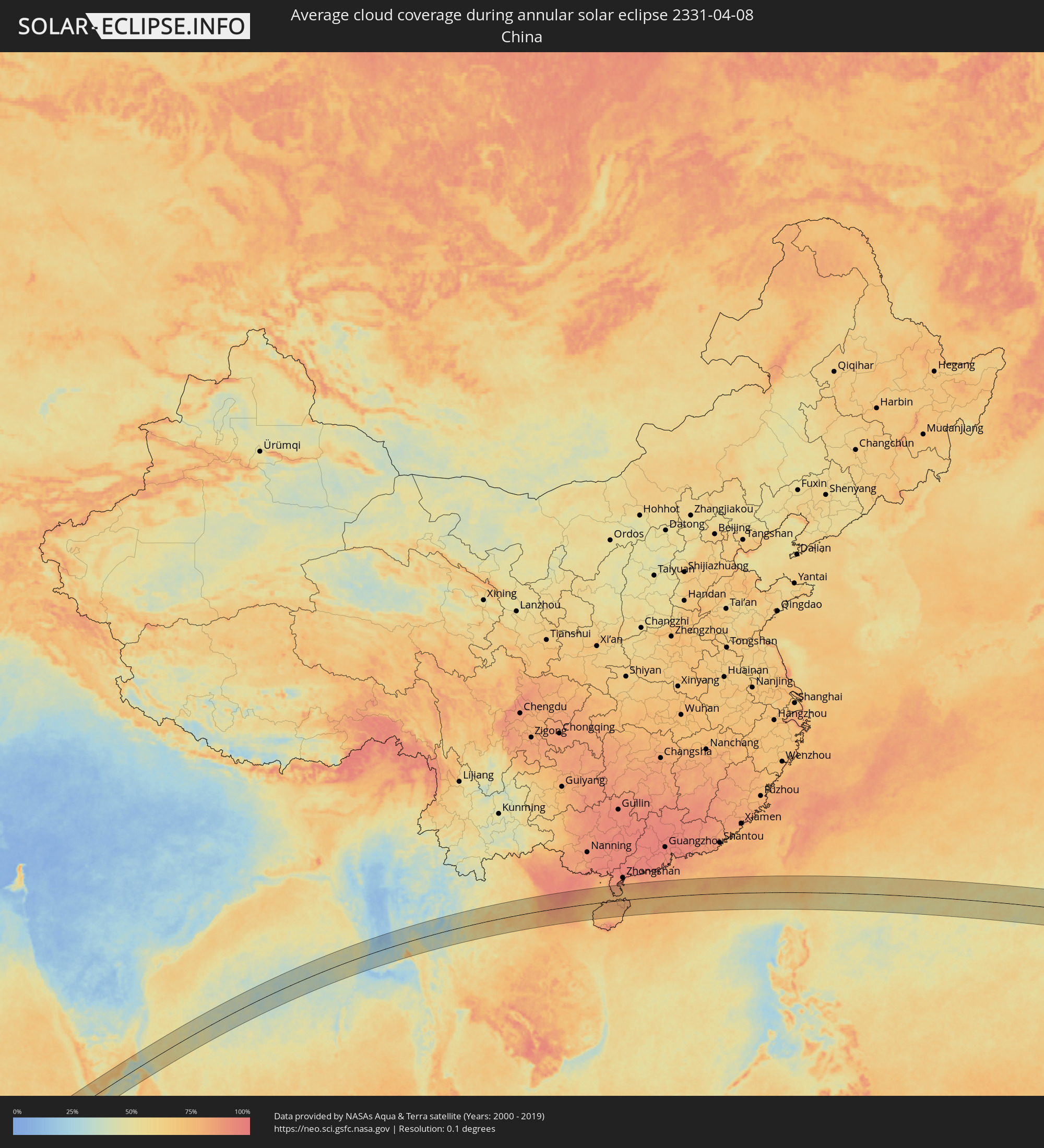 China
China
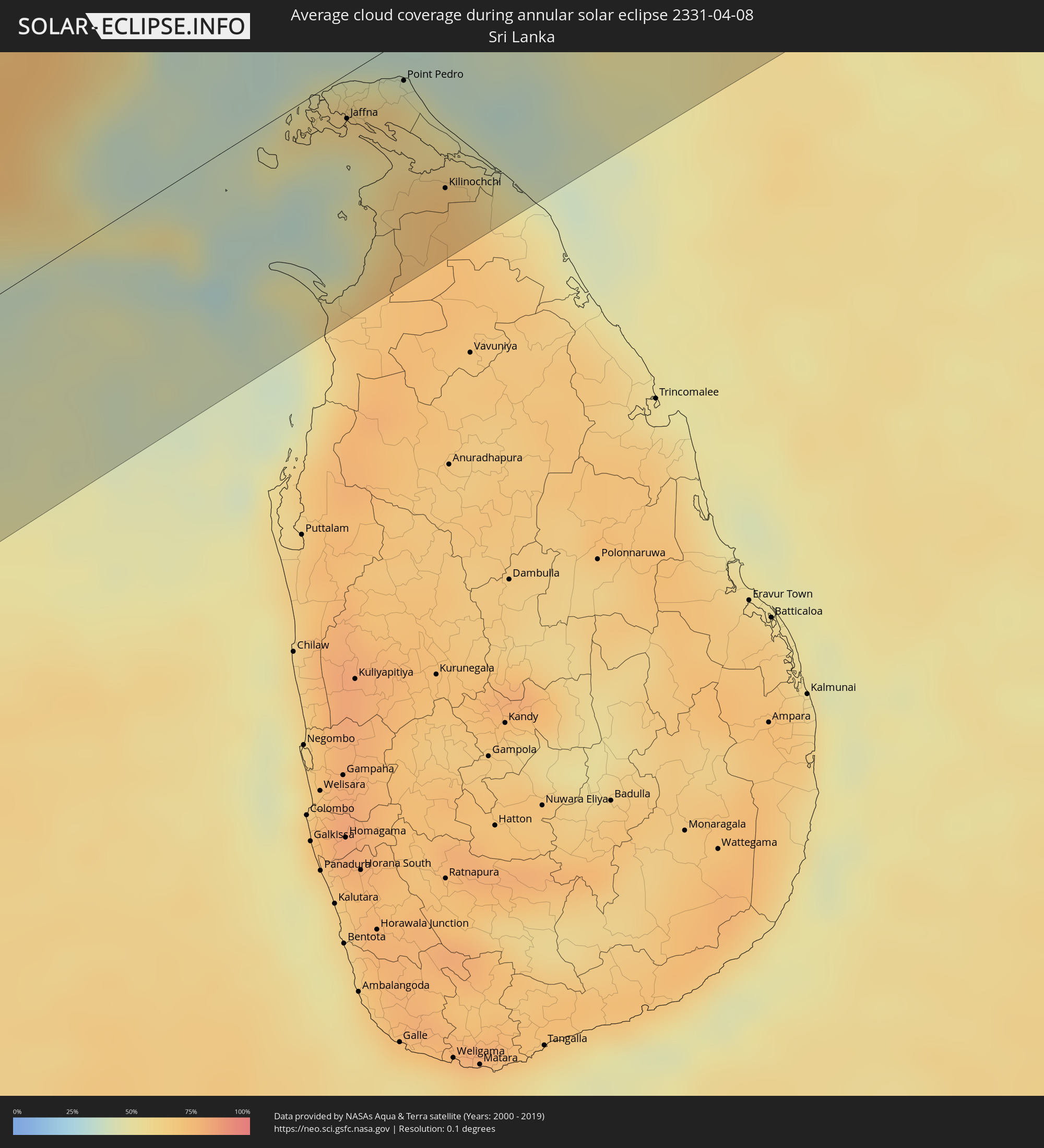 Sri Lanka
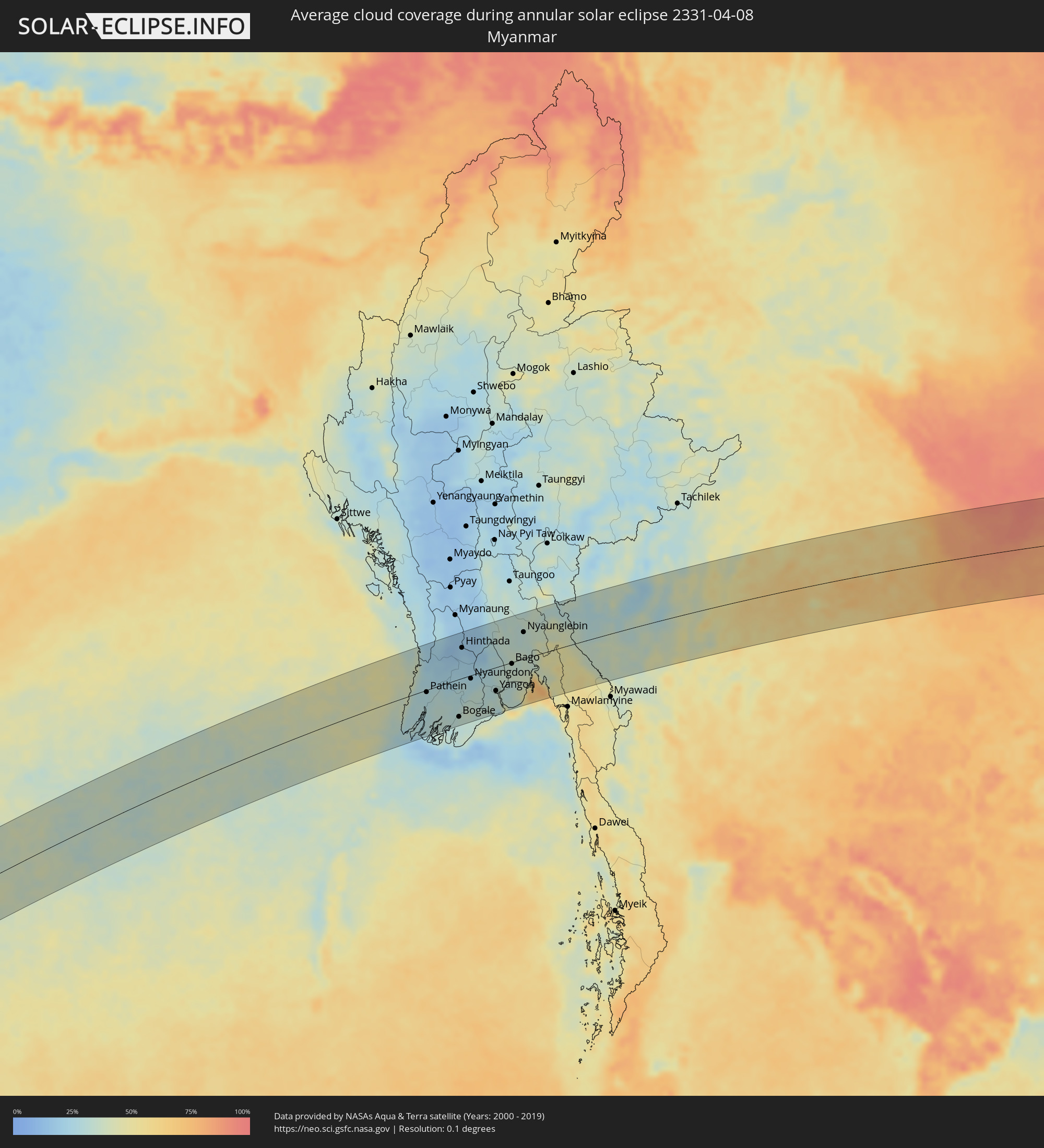 Myanmar
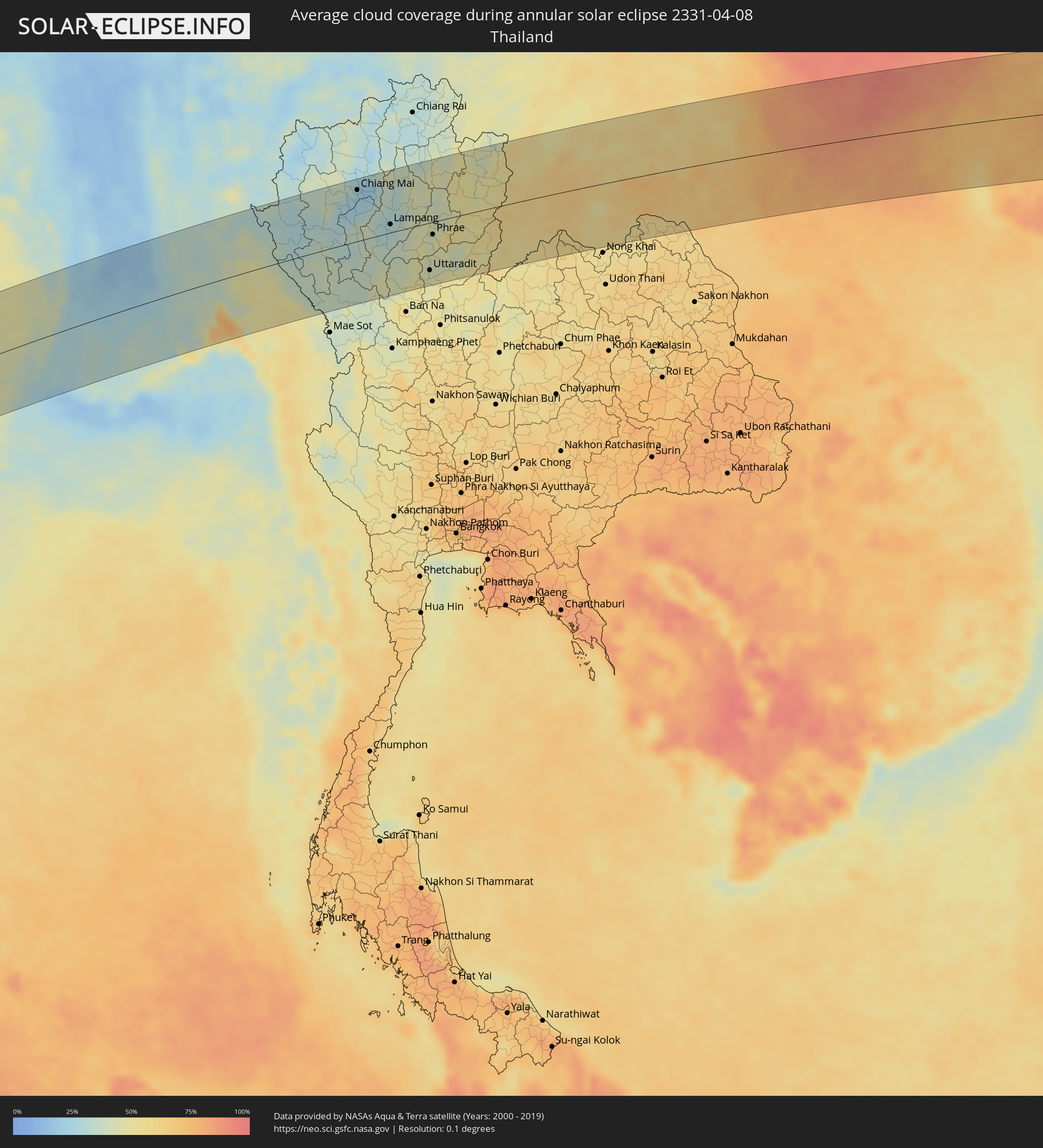 Thailand
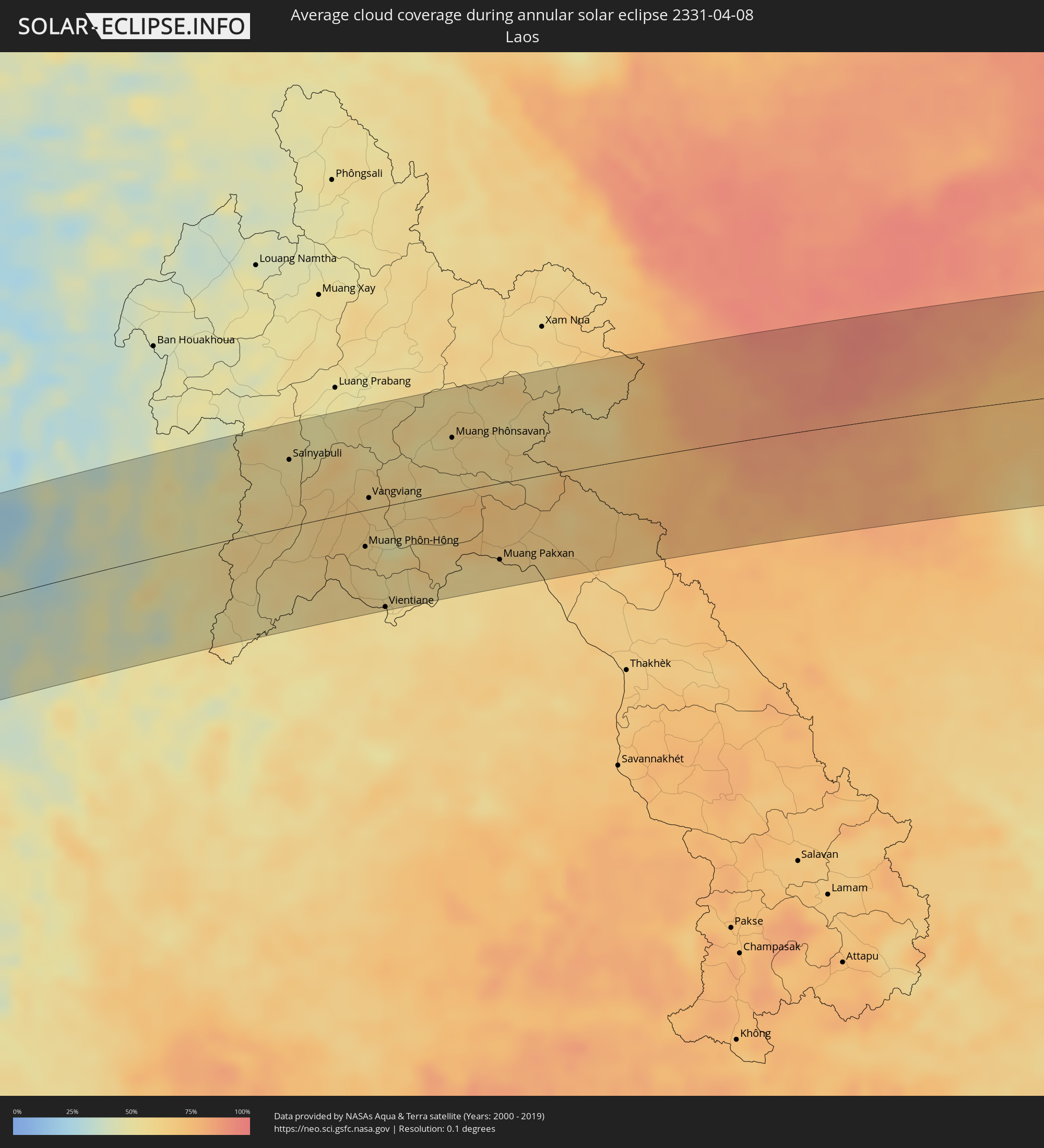 Laos
Laos
 Vietnam
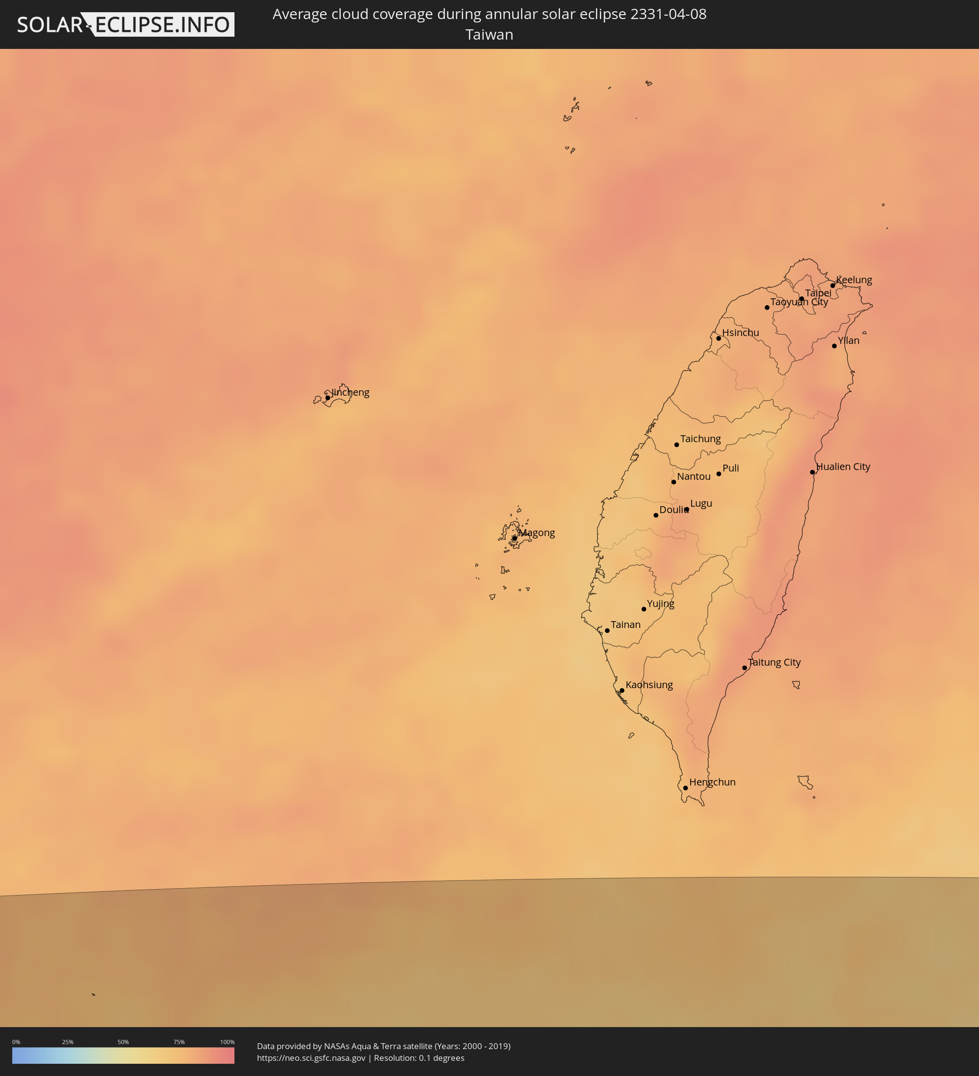 Taiwan
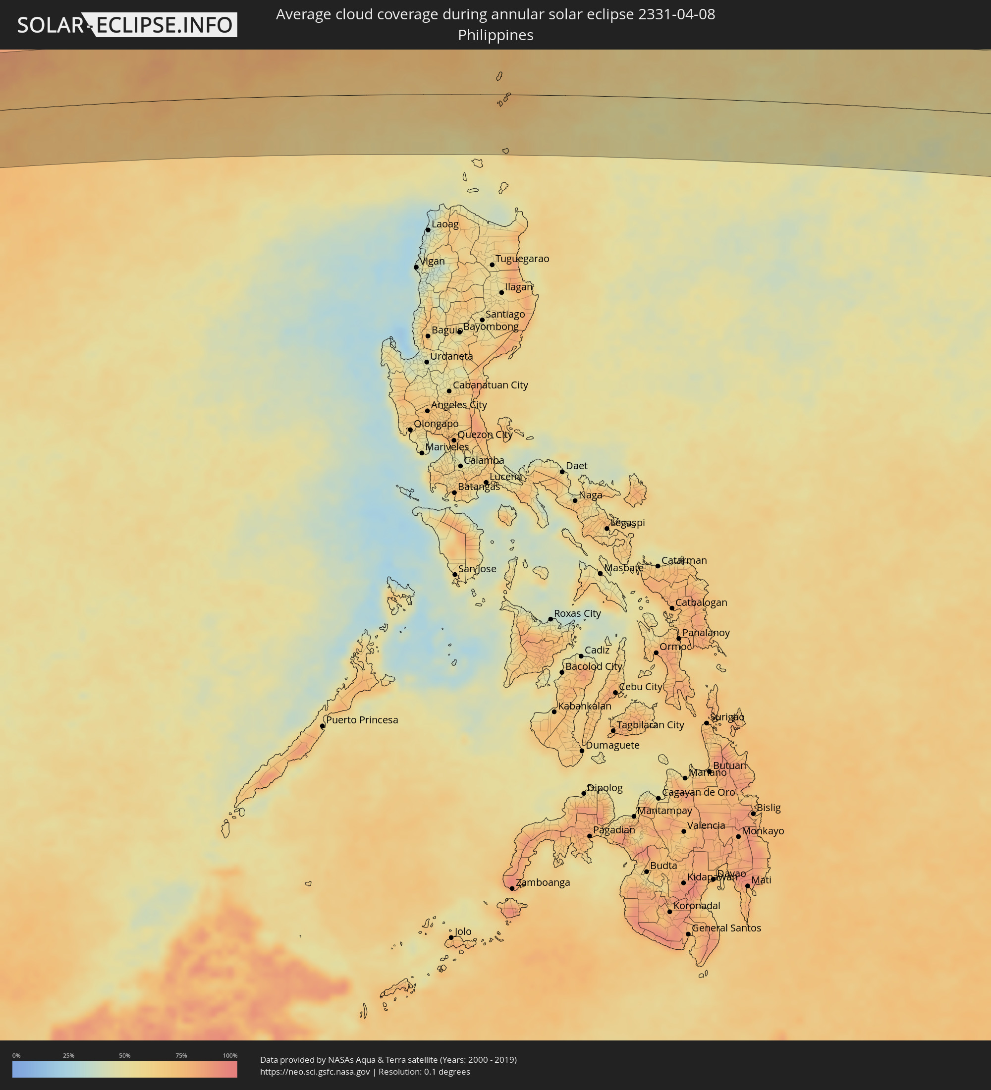 Philippines
Cities inside the path of the eclipse
The following table shows all locations with a population of more than 5,000 inside the eclipse path. Cities which have more than 100,000 inhabitants are marked bold. A click at the locations opens a detailed map.
| City | Type | Eclipse duration | Local time of max. eclipse | Distance to central line | Ø Cloud coverage |
|
Kalabo, Western
|
annular | - | 06:47:13 UTC+02:00 | 103 km | 34% |
|
Kaoma, Western
|
annular | - | 06:47:25 UTC+02:00 | 116 km | 53% |
|
Kalengwa, North-Western
|
annular | - | 06:47:45 UTC+02:00 | 26 km | 55% |
|
Kalulushi, Copperbelt
|
annular | - | 06:48:30 UTC+02:00 | 40 km | 65% |
|
Mpongwe, Copperbelt
|
annular | - | 06:48:19 UTC+02:00 | 35 km | 60% |
|
Kitwe, Copperbelt
|
annular | - | 06:48:33 UTC+02:00 | 42 km | 64% |
|
Mufulira, Copperbelt
|
annular | - | 06:48:38 UTC+02:00 | 69 km | 68% |
|
Luanshya, Copperbelt
|
annular | - | 06:48:29 UTC+02:00 | 1 km | 62% |
|
Ndola, Copperbelt
|
annular | - | 06:48:36 UTC+02:00 | 17 km | 61% |
|
Kapiri Mposhi, Central
|
annular | - | 06:48:18 UTC+02:00 | 95 km | 64% |
|
Mkushi, Central
|
annular | - | 06:48:36 UTC+02:00 | 71 km | 63% |
|
Kataba, Copperbelt
|
annular | - | 06:49:19 UTC+02:00 | 112 km | 41% |
|
Serenje, Central
|
annular | - | 06:48:58 UTC+02:00 | 45 km | 65% |
|
Mpika, Muchinga Province
|
annular | - | 06:49:54 UTC+02:00 | 82 km | 70% |
|
Lundazi, Eastern
|
annular | - | 06:50:25 UTC+02:00 | 6 km | 65% |
|
Kasungu, Central Region
|
annular | - | 06:50:16 UTC+02:00 | 94 km | 71% |
|
Mzimba, Northern Region
|
annular | - | 06:50:47 UTC+02:00 | 27 km | 68% |
|
Mzuzu, Northern Region
|
annular | - | 06:51:10 UTC+02:00 | 64 km | 87% |
|
Nkhata Bay, Northern Region
|
annular | - | 06:51:14 UTC+02:00 | 42 km | 61% |
|
Nkhotakota, Central Region
|
annular | - | 06:50:41 UTC+02:00 | 101 km | 43% |
|
Mbinga, Ruvuma
|
annular | - | 07:51:55 UTC+03:00 | 98 km | 90% |
|
Tingi, Ruvuma
|
annular | - | 07:51:45 UTC+03:00 | 57 km | 89% |
|
Kigonsera, Ruvuma
|
annular | - | 07:52:00 UTC+03:00 | 111 km | 87% |
|
Songea, Ruvuma
|
annular | - | 07:52:24 UTC+03:00 | 109 km | 89% |
|
Nangomba, Mtwara
|
annular | - | 07:54:03 UTC+03:00 | 10 km | 80% |
|
Nachingwea, Lindi
|
annular | - | 07:54:32 UTC+03:00 | 59 km | 78% |
|
Masasi, Mtwara
|
annular | - | 07:54:22 UTC+03:00 | 21 km | 82% |
|
Lukuledi, Mtwara
|
annular | - | 07:54:27 UTC+03:00 | 37 km | 80% |
|
Nanganga, Mtwara
|
annular | - | 07:54:48 UTC+03:00 | 47 km | 81% |
|
Nyangao, Lindi
|
annular | - | 07:54:56 UTC+03:00 | 48 km | 79% |
|
Newala Kisimani, Mtwara
|
annular | - | 07:54:35 UTC+03:00 | 18 km | 69% |
|
Tandahimba, Mtwara
|
annular | - | 07:54:57 UTC+03:00 | 6 km | 76% |
|
Lindi, Lindi
|
annular | - | 07:55:27 UTC+03:00 | 72 km | 73% |
|
Nanyamba, Mtwara
|
annular | - | 07:55:08 UTC+03:00 | 5 km | 77% |
|
Mtwara, Mtwara
|
annular | - | 07:55:39 UTC+03:00 | 29 km | 74% |
|
Mocímboa, Cabo Delgado
|
annular | - | 06:55:09 UTC+02:00 | 88 km | 63% |
|
Port Glaud, Port Glaud
|
annular | - | 09:19:13 UTC+04:00 | 35 km | 44% |
|
Bel Ombre, Bel Ombre
|
annular | - | 09:19:17 UTC+04:00 | 40 km | 57% |
|
Beau Vallon, Beau Vallon
|
annular | - | 09:19:18 UTC+04:00 | 39 km | 57% |
|
Victoria, English River
|
annular | - | 09:19:21 UTC+04:00 | 38 km | 55% |
|
Anse Boileau, Anse Boileau
|
annular | - | 09:19:16 UTC+04:00 | 27 km | 53% |
|
Takamaka, Takamaka
|
annular | - | 09:19:14 UTC+04:00 | 21 km | 44% |
|
Cascade, Cascade
|
annular | - | 09:19:22 UTC+04:00 | 31 km | 53% |
|
Anse Royale, Anse Royale
|
annular | - | 09:19:19 UTC+04:00 | 23 km | 53% |
|
La Passe, Inner Islands
|
annular | - | 09:20:20 UTC+04:00 | 47 km | 53% |
|
Ugoofaaru, Raa Atoll
|
annular | - | 11:18:16 UTC+05:00 | 33 km | 51% |
|
Eydhafushi, Baa Atholhu
|
annular | - | 11:17:14 UTC+05:00 | 21 km | 54% |
|
Funadhoo, Shaviyani Atholhu
|
annular | - | 11:20:01 UTC+05:00 | 62 km | 62% |
|
Naifaru, Lhaviyani Atholhu
|
annular | - | 11:18:47 UTC+05:00 | 8 km | 53% |
|
Manadhoo, Noonu Atoll
|
annular | - | 11:19:35 UTC+05:00 | 19 km | 59% |
|
Vettūr, Kerala
|
annular | - | 12:05:38 UTC+05:30 | 87 km | 57% |
|
Thiruvananthapuram, Kerala
|
annular | - | 12:05:51 UTC+05:30 | 54 km | 60% |
|
Neyyāttinkara, Kerala
|
annular | - | 12:06:06 UTC+05:30 | 38 km | 67% |
|
Kadayanallur, Tamil Nadu
|
annular | - | 12:08:16 UTC+05:30 | 85 km | 58% |
|
Nāgercoil, Tamil Nadu
|
annular | - | 12:06:44 UTC+05:30 | 4 km | 62% |
|
Tirunelveli, Tamil Nadu
|
annular | - | 12:08:37 UTC+05:30 | 32 km | 66% |
|
Kovilpatti, Tamil Nadu
|
annular | - | 12:10:06 UTC+05:30 | 63 km | 72% |
|
Aruppukkottai, Tamil Nadu
|
annular | - | 12:11:28 UTC+05:30 | 81 km | 67% |
|
Kayalpattinam, Tamil Nadu
|
annular | - | 12:09:40 UTC+05:30 | 8 km | 47% |
|
Sivaganga, Tamil Nadu
|
annular | - | 12:13:22 UTC+05:30 | 90 km | 67% |
|
Paramagudi, Tamil Nadu
|
annular | - | 12:13:06 UTC+05:30 | 55 km | 73% |
|
Devakottai, Tamil Nadu
|
annular | - | 12:14:37 UTC+05:30 | 79 km | 72% |
|
Ramanathapuram, Tamil Nadu
|
annular | - | 12:13:30 UTC+05:30 | 25 km | 60% |
|
Arantāngi, Tamil Nadu
|
annular | - | 12:15:35 UTC+05:30 | 90 km | 72% |
|
Rameswaram, Tamil Nadu
|
annular | - | 12:14:51 UTC+05:30 | 12 km | 54% |
|
Jaffna, Northern Province
|
annular | - | 12:17:47 UTC+05:30 | 16 km | 57% |
|
Valvedditturai, Northern Province
|
annular | - | 12:18:35 UTC+05:30 | 12 km | 61% |
|
Point Pedro, Northern Province
|
annular | - | 12:18:47 UTC+05:30 | 16 km | 61% |
|
Kilinochchi, Northern Province
|
annular | - | 12:18:29 UTC+05:30 | 65 km | 71% |
|
Pathein, Ayeyarwady
|
annular | - | 14:13:02 UTC+06:30 | 4 km | 27% |
|
Bogale, Ayeyarwady
|
annular | - | 14:14:19 UTC+06:30 | 78 km | 33% |
|
Hinthada, Ayeyarwady
|
annular | - | 14:15:45 UTC+06:30 | 63 km | 21% |
|
Maubin, Ayeyarwady
|
annular | - | 14:15:24 UTC+06:30 | 41 km | 32% |
|
Pyapon, Ayeyarwady
|
annular | - | 14:15:02 UTC+06:30 | 89 km | 33% |
|
Kyaiklat, Ayeyarwady
|
annular | - | 14:15:19 UTC+06:30 | 73 km | 32% |
|
Tharyarwady, Bago
|
annular | - | 14:16:36 UTC+06:30 | 53 km | 19% |
|
Kanbe, Yangon
|
annular | - | 14:16:17 UTC+06:30 | 54 km | 33% |
|
Yangon, Yangon
|
annular | - | 14:16:46 UTC+06:30 | 49 km | 34% |
|
Bago, Bago
|
annular | - | 14:18:04 UTC+06:30 | 3 km | 36% |
|
Thongwa, Yangon
|
annular | - | 14:17:40 UTC+06:30 | 66 km | 36% |
|
Nyaunglebin, Bago
|
annular | - | 14:19:12 UTC+06:30 | 55 km | 32% |
|
Kyaikto, Mon
|
annular | - | 14:19:23 UTC+06:30 | 22 km | 39% |
|
Thaton, Mon
|
annular | - | 14:19:56 UTC+06:30 | 75 km | 49% |
|
Hpa-an, Kayin
|
annular | - | 14:20:34 UTC+06:30 | 86 km | 51% |
|
San Pa Tong, Chiang Mai
|
annular | - | 14:54:56 UTC+07:00 | 65 km | 25% |
|
Hang Dong, Chiang Mai
|
annular | - | 14:55:01 UTC+07:00 | 71 km | 25% |
|
Pa Sang, Lamphun
|
annular | - | 14:54:57 UTC+07:00 | 53 km | 25% |
|
Chiang Mai, Chiang Mai
|
annular | - | 14:55:14 UTC+07:00 | 80 km | 26% |
|
Lamphun, Lamphun
|
annular | - | 14:55:09 UTC+07:00 | 57 km | 25% |
|
San Kamphaeng, Chiang Mai
|
annular | - | 14:55:31 UTC+07:00 | 72 km | 24% |
|
Thoen, Lampang
|
annular | - | 14:54:58 UTC+07:00 | 53 km | 41% |
|
Lampang, Lampang
|
annular | - | 14:56:05 UTC+07:00 | 13 km | 27% |
|
Si Satchanalai, Sukhothai
|
annular | - | 14:56:10 UTC+07:00 | 78 km | 49% |
|
Dok Kham Tai, Phayao
|
annular | - | 14:57:46 UTC+07:00 | 94 km | 38% |
|
Den Chai, Phrae
|
annular | - | 14:57:09 UTC+07:00 | 35 km | 42% |
|
Uttaradit, Uttaradit
|
annular | - | 14:57:01 UTC+07:00 | 75 km | 44% |
|
Phrae, Phrae
|
annular | - | 14:57:28 UTC+07:00 | 20 km | 42% |
|
Pong, Phayao
|
annular | - | 14:58:23 UTC+07:00 | 86 km | 43% |
|
Nan, Nan
|
annular | - | 14:59:17 UTC+07:00 | 34 km | 46% |
|
Sainyabuli, Xiagnabouli
|
annular | - | 15:01:33 UTC+07:00 | 64 km | 54% |
|
Muang Phôn-Hông, Vientiane Province
|
annular | - | 15:02:39 UTC+07:00 | 35 km | 60% |
|
Vangviang, Vientiane Province
|
annular | - | 15:02:56 UTC+07:00 | 11 km | 64% |
|
Vientiane, Vientiane
|
annular | - | 15:02:45 UTC+07:00 | 97 km | 54% |
|
Muang Phônsavan, Xiangkhoang
|
annular | - | 15:04:46 UTC+07:00 | 52 km | 57% |
|
Muang Pakxan, Bolikhamsai Province
|
annular | - | 15:05:10 UTC+07:00 | 73 km | 57% |
|
Yên Vinh, Nghệ An
|
annular | - | 15:09:15 UTC+07:00 | 79 km | 76% |
|
Vinh, Nghệ An
|
annular | - | 15:09:18 UTC+07:00 | 79 km | 76% |
|
Thanh Hóa, Thanh Hóa
|
annular | - | 15:09:50 UTC+07:00 | 44 km | 83% |
|
Bỉm Sơn, Thanh Hóa
|
annular | - | 15:10:06 UTC+07:00 | 73 km | 84% |
|
Thành Phố Ninh Bình, Ninh Bình
|
annular | - | 15:10:22 UTC+07:00 | 91 km | 89% |
|
Lincheng, Hainan
|
annular | - | 16:16:36 UTC+08:00 | 1 km | 80% |
|
Jinjiang, Hainan
|
annular | - | 16:17:04 UTC+08:00 | 23 km | 79% |
|
Xucheng, Guangdong
|
annular | - | 16:17:25 UTC+08:00 | 42 km | 77% |
|
Xiuying, Hainan
|
annular | - | 16:17:34 UTC+08:00 | 4 km | 80% |
|
Haikou, Hainan
|
annular | - | 16:17:39 UTC+08:00 | 8 km | 80% |
|
Qiongshan, Hainan
|
annular | - | 16:17:40 UTC+08:00 | 4 km | 79% |
|
Basco, Cagayan Valley
|
annular | - | 16:31:30 UTC+08:00 | 1 km | 73% |